monitoring and managing our terrestrial ecosystems - nisar · monitoring and managing our...
TRANSCRIPT
National Aeronautics and Space Administration
Monitoring and Managing Our Terrestrial Ecosystems
NASA–ISRO SAR Mission
NISAR will determine the contribution of Earth’s biomass to the global carbon budget and characterize ecosystem disturbance and impacts on biodiversity.
that generate food, fiber, energy, and living spaces for a growing global population. It is imperative to understand the connections between natural resource management and ecosystem responses to create a sustainable future.
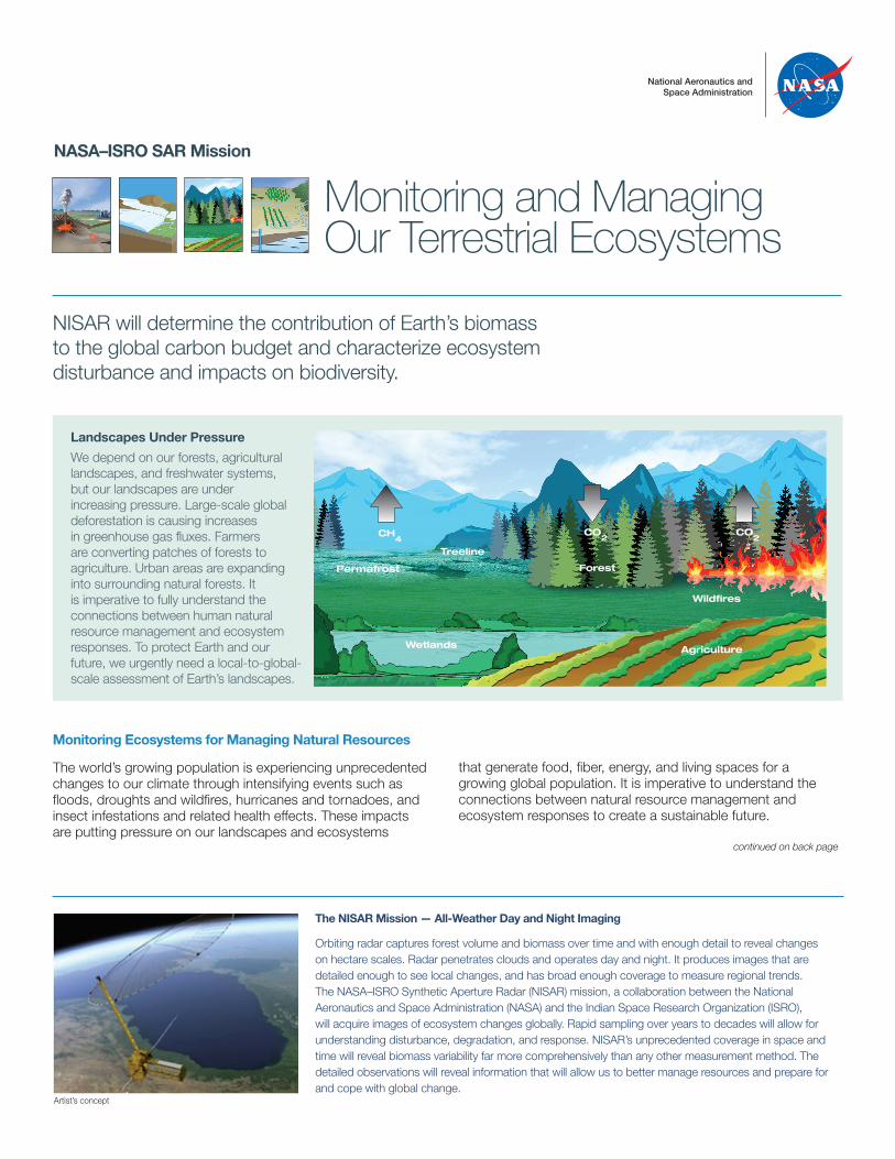
Landscapes Under Pressure
We depend on our forests, agricultural landscapes, and freshwater systems, but our landscapes are under increasing pressure. Large-scale global deforestation is causing increases in greenhouse gas fluxes. Farmers are converting patches of forests to agriculture. Urban areas are expanding into surrounding natural forests. It is imperative to fully understand the connections between human natural resource management and ecosystem responses. To protect Earth and our future, we urgently need a local-to-global-scale assessment of Earth’s landscapes.
Treeline
Permafrost
Wildfires
Wetlands
Forest
Agriculture
CH4
CO2
CO2
Monitoring Ecosystems for Managing Natural Resources
The world’s growing population is experiencing unprecedented changes to our climate through intensifying events such as floods, droughts and wildfires, hurricanes and tornadoes, and insect infestations and related health effects. These impacts are putting pressure on our landscapes and ecosystems
The NISAR Mission — All-Weather Day and Night Imaging
Orbiting radar captures forest volume and biomass over time and with enough detail to reveal changes on hectare scales. Radar penetrates clouds and operates day and night. It produces images that are detailed enough to see local changes, and has broad enough coverage to measure regional trends. The NASA–ISRO Synthetic Aperture Radar (NISAR) mission, a collaboration between the National Aeronautics and Space Administration (NASA) and the Indian Space Research Organization (ISRO), will acquire images of ecosystem changes globally. Rapid sampling over years to decades will allow for understanding disturbance, degradation, and response. NISAR’s unprecedented coverage in space and time will reveal biomass variability far more comprehensively than any other measurement method. The detailed observations will reveal information that will allow us to better manage resources and prepare for and cope with global change.
continued on back page
Artist’s concept
For more information, visit: http://nisar.jpl.nasa.gov
JPL 400-1564 Rev. 1 12/16
National Aeronautics and Space Administration
Jet Propulsion LaboratoryCalifornia Institute of TechnologyPasadena, California
www.nasa.gov
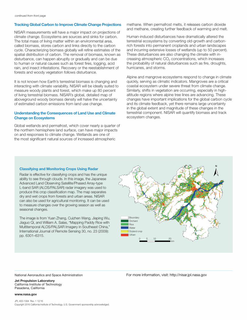
Classifying and Monitoring Crops Using Radar
Radar is effective for classifying crops and has the unique ability to see through clouds. In this image, the Japanese Advanced Land Observing Satellite/Phased Array-type L-band SAR (ALOS/PALSAR) radar imagery was used to produce this crop classification map. The map separates dry and wet crops from forests and urban areas. NISAR can also be used for agricultural monitoring. It can be used to measure changes over the growing season as well as seasonal changes.
The image is from Yuan Zhang, Cuizhen Wang, Jiaping Wu, Jiaguo Qi, and William A. Salas, “Mapping Paddy Rice with Multitemporal ALOS/PALSAR Imagery in Southeast China,” International Journal of Remote Sensing 30, no. 23 (2009): pp. 6301–6315.
BoundaryOrchardRiceWaterDryland cropUrban
0 5 10 20km
N
continued from front page
Tracking Global Carbon to Improve Climate Change Projections
NISAR measurements will have a major impact on projections of climate change. Ecosystems are sources and sinks for carbon. The total mass of living matter within an environmental area, called biomass, stores carbon and links directly to the carbon cycle. Characterizing biomass globally will refine estimates of the spatial distribution of carbon. The removal of biomass, known as disturbance, can happen abruptly or gradually and can be due to human or natural causes such as forest fires, logging, acid rain, and insect infestations. Recovery or the reestablishment of forests and woody vegetation follows disturbance.
It is not known how Earth’s terrestrial biomass is changing and interacting with climate variability. NISAR will be ideally suited to measure woody plants and forest, which make up 80 percent of living terrestrial biomass. NISAR’s global, detailed map of aboveground woody biomass density will halve the uncertainty of estimated carbon emissions from land use change.
Understanding the Consequences of Land Use and Climate Change on Ecosystems
Global wetlands and permafrost, which cover nearly a quarter of the northern hemisphere land surface, can have major impacts on and responses to climate change. Wetlands are one of the most significant natural sources of increased atmospheric
methane. When permafrost melts, it releases carbon dioxide and methane, creating further feedback of warming and melt.
Human-induced disturbances have dramatically altered the terrestrial ecosystems by converting old-growth and carbon-rich forests into permanent croplands and urban landscapes and incurring extensive losses of wetlands (up to 50 percent). These disturbances are also changing the climate with in-creasing atmospheric CO2 concentrations, which increases the probability of natural disturbances such as fire, droughts, hurricanes, and storms.
Alpine and mangrove ecosystems respond to change in climate quickly, serving as climatic indicators. Mangroves are a critical coastal ecosystem under severe threat from climate change. Similarly, shifts in vegetation are occurring, especially in high-altitude regions where alpine tree lines are advancing. These changes have important implications for the global carbon cycle and its climate feedback, yet there remains large uncertainty in the global extent and magnitude of these changes in the terrestrial component. NISAR will quantify biomass and track ecosystem changes.
Copyright 2016 California Institute of Technology. U.S. Government sponsorship acknowledged.