modeling a snowmelt-dominated watershed in northern … · model of a snowmelt-dominated watershed...
TRANSCRIPT

Modeling a Snowmelt-Dominated Watershed
in Northern Utah Using GSSHA
Benjamin G. Thompson
A project submitted to the faculty of
Brigham Young University
in partial fulfillment of the requirements for the degree of
Master of Science
E. James Nelson, Chair
Norman L. Jones
A. Woodruff Miller
Department of Civil and Environmental Engineering
Brigham Young University
August 2014


ABSTRACT
Modeling a Snowmelt-Dominated Watershed
in Northern Utah Using GSSHA
Benjamin G. Thompson
Department of Civil & Environmental Engineering, BYU
Master of Science
The scarcity of water in the Intermountain West makes it important for all who live in the
region to understand its importance and manage this valuable resource. The CI-WATER research
group is developing cyber-infrastructure to help aid those in charge of managing water as well as
the rising generation of water scientists to accomplish this. One aspect of CI-WATER is to
develop open-source web-based computing applications that provide greater access to students,
scientists, and decision makers. The purpose of this project is to provide a calibrated hydrologic
model of a snowmelt-dominated watershed in northern Utah by using the newly created and
updated snowmelt parameters within Gridded Surface Subsurface Hydrologic Analysis
(GSSHA) for testing the CI-WATER web-based applications. The model could also be
implemented in the use of a modeling system being developed at the University of Utah used for
municipal water supply and demand forecasting.
A long-term hydrologic model simulation was developed for a one-water year time
period using GSSHA. This physically-based model was developed by the U.S. Army Corps of
Engineers Engineer Research and Development Center (USACE ERDC). Pre- and post-
processing of the model was done with the aid of Watershed Modeling System (WMS) software
designed by Aquaveo, LLC. Both GSSHA and WMS have seen many improvements to the long-
term and snowmelt modeling capabilities and continue to be improved upon. This study details
the capabilities and limitations of the ability of GSSHA to simulate snowmelt runoff as of this
writing.
Keywords: snowmelt modeling, long-term, GSSHA, WMS, cyber-infrastructure, CI-WATER,
USACE ERDC


ACKNOWLEDGEMENTS
I would like to thank Dr. E. James Nelson for including me in the CI-WATER team and
allowing me to research something I am passionate about. His help and guidance has not only
helped me achieve my academic goals, but has also helped shape my career path. I would also
like to acknowledge the guidance of Dr. Norman L. Jones and Dr. A. Woodruff Miller for their
input and advice. The entire CI-WATER team was an immense help in completing this project,
especially the help from Scott Christensen, Nathan Swain, Herman Dolder, and Fidel Perez.
I’d like to thank former graduate student Jeff McCarty for doing much of the work in
setting up the initial GSSHA model, searching for relevant data, and allowing me access to all of
his research for this project. I want to express my gratitude to Chuck Downer and Mike Follum
at ERDC for their hard work on improving the GSSHA snowmelt parameters, as well as their
patience in answering all of my questions.
Lastly, and most importantly, I want to thank my beautiful wife Jennica for her love and
support. Her positive attitude and encouragement as I finish my education is the only reason I
have been able to accomplish so much.
This material is based upon work supported by the National Science Foundation under
Grant No. 1135482.


TABLE OF CONTENTS
LIST OF FIGURES ..................................................................................................................... ix
1 INTRODUCTION ................................................................................................................. 1
1.1 CI-WATER Background ................................................................................................ 2
1.2 Literature Review ........................................................................................................... 3
1.3 GSSHA and WMS Background ..................................................................................... 5
1.4 GSSHA Snowmelt Modeling Overview ......................................................................... 6
2 LONG-TERM MODEL DEVELOPMENT ....................................................................... 9
2.1 Basic Model Setup .......................................................................................................... 9
2.2 Long-Term Simulation ................................................................................................. 15
2.2.1 Precipitation Data ...................................................................................................... 16
2.2.2 Hydrometeorological Data ........................................................................................ 16
3 SNOWMELT MODELING IN GSSHA ........................................................................... 19
3.1 Snowmelt Analysis Options .......................................................................................... 19
3.1.1 Temperature Index .................................................................................................... 19
3.1.2 Energy Balance ......................................................................................................... 20
3.1.3 Hybrid Energy Balance ............................................................................................. 20
3.2 Continuous Frozen Ground Index ................................................................................. 20
3.3 Lateral Melt-Water Transport ....................................................................................... 21
3.4 Orographic Effects ........................................................................................................ 22
3.5 Little Dell Snowmelt Parameters .................................................................................. 24
4 CONCEPTUAL GROUNDWATER MODEL ................................................................. 25
5 RESULTS AND DISCUSSION ......................................................................................... 31
5.1 Matching the Runoff Timing ........................................................................................ 32

vi
5.2 Lowering the Discharge Peaks ..................................................................................... 34
5.3 Increasing the Volume .................................................................................................. 35
6 CONSLUSIONS .................................................................................................................. 37
REFERENCES ............................................................................................................................ 41

vii
LIST OF TABLES
Table 1: Stream arc attributes assigned to Little Dell basin ..................................................12
Table 2: Roughness Values of Little Dell Watershed ............................................................14
Table 3: Evapotranspiration Values of Little Dell Watershed ...............................................14
Table 4: Infiltration Values of Little Dell Watershed ............................................................14
Table 5: Temperature inconsistencies from the HMET data used for the Little Dell
GSSHA model ...........................................................................................................23
Table 6: Snowmelt parameter cards used in Little Dell model ..............................................24
Table 7: Conceptual groundwater parameter values ..............................................................26
Table 8: GSSHA snow cards with recommended starting values and sensitivity levels .......38

viii

ix
LIST OF FIGURES
Figure 1: CI-WATER Data & Modeling Services .................................................................3
Figure 2: Project location tool within WMS ..........................................................................10
Figure 3: Delineated watershed produced by WMS ..............................................................11
Figure 4: Little Dell watershed with GSSHA grid applied ....................................................12
Figure 5: Soil Type Index Map ..............................................................................................13
Figure 6: Long-Term Simulation parameters window in WMS ............................................15
Figure 7: Portion of HMET file used for Little Dell model ...................................................18
Figure 8: Example of Params.con file in project folder .........................................................26
Figure 9: Gw boundary index map after regeneration ...........................................................27
Figure 10: Groundwater boundary file ..................................................................................28
Figure 11: Example of Map.lik file ........................................................................................28
Figure 12: Conceptual groundwater project file cards ...........................................................29
Figure 13: Observed discharge at outlet of Little Dell watershed .........................................32
Figure 14: Comparison of Vegetation Radiation Coefficient values .....................................33
Figure 15: Comparison of airport and SNOTEL temperatures in HMET file .......................35
Figure 16: Comparison of Little Dell model with and without conceptual groundwater
model..........................................................................................................................36


1
1 INTRODUCTION
The complexity of snowmelt processes makes it difficult to simulate runoff for a
watershed that is snowmelt-dominated. Most lumped models are limited in this aspect and do not
consider snowmelt. Currently, most snowmelt runoff is predicted using historical data.
Unfortunately, historical data cannot predict the impacts of runoff after changes such as
population growth, climate change, and land use change due to development or wildfires. These
predictions could prove difficult for water managers and others throughout the Intermountain
West where snowmelt accounts for a significant portion of the drinking water supply. Efforts
have been made in recent years to model snowmelt with models such as SNOW17 and SWAT
with mixed results (Debele, Srinivasan, & Gosain, 2010; Raleigh & Lundquist, 2012).
This purpose of this project is to test the newly created and updated snowmelt parameters
using GSSHA and create a calibrated hydrologic model of a snowmelt-dominated watershed in
northern Utah to be used for testing open-source hydrologic web-based applications created
through the CI-WATER project. These applications could then be used by other researchers,
water managers, planners, and the general public. The model could also provide useful input for
CI-WATER researchers at the University of Utah who are creating a municipal water supply and
demand model.
The current release version of GSSHA (v6.1) is supported by the graphical user interface
software WMS that helps with pre-and post-processing of the model data in order to create
properly formatted GSSHA input files. However, all of the research for this project was done

2
using the GSSHA Beta version 6.2, which has several new and improved features for modeling
snowmelt. This project tested the snowmelt modeling capabilities of the latest version of GSSHA
and makes recommendations for using different options associated with snowmelt. It also
incorporates a conceptual groundwater model to account for infiltrated melt water.
1.1 CI-WATER Background
The CI-WATER project grant from the NSF is a collaboration between researchers from
the University of Utah, Brigham Young University, Utah State University, and the University of
Wyoming. The purpose of the project is to better understand the water resources systems and
problems facing the Intermountain West. This has been and continues to be done through high-
performance computer modeling and a cyberinfrastructure of computational resources.
Components of the project include enhanced cyberinfrastructure facilities, including a
supercomputer at the University of Wyoming and a large and accessible database at Utah State
University. Other components include open-source web-based applications for water resource
modeling and management purposes as well as an education and outreach program for future
water managers and scientists, as seen illustrated in Figure 1(CI-WATER, 2012).

3
Figure 1: CI-WATER Data & Modeling Services
The web-based application development is being done by several researchers at BYU.
Some of the various applications include early flood-warning systems, land-use changes, urban
drainage, and stochastic modeling. With all of the applications being open-source, they can then
be used and modified to fit the specific needs of water managers, planners, students, or any other
interested party. The GSSHA model created for this project has and will be used to test
components of these applications, especially those that incorporate snowmelt modeling.
1.2 Literature Review
Ellis, Pomeroy, and Link (2013) illustrate the need for modeling snowmelt rather than
only using historical data to predict snowmelt runoff in an area undergoing a change in land use.
They used a physically-based model to investigate the effects of forest gap-thinning treatments in
the Canadian Rocky Mountains. Their field observations and model results confirmed a change
in snow accumulation in small clear-cut gaps in the forest. The small clear-cut gaps accumulated

4
roughly twice the amount of snow than those under intact forest cover due to sublimation losses
from the canopy. This resulted in a significant increase in runoff.
Leavesley (1989) addresses problems associated with trying to model snowmelt runoff.
Among the problems listed is the measurement or estimation of snow accumulation, snowmelt,
and runoff process parameters for a range of applications and scales. He details the difficulties
associated with developing accurate short-term and long-term snowmelt runoff forecasts. One of
the hopes of this project is to improve the ability and the accuracy of snowmelt runoff with a
calibrated GSSHA snowmelt model.
Debele et al. (2010) have compared the differences between a temperature-index and
process-based model using SWAT. They achieved better results with the temperature-index
model, which has also been the case with the temperature-index snowmelt analysis option in
GSSHA. However, it has proven to be more difficult to calibrate in GSSHA than with an energy
balance analysis because it ignores the complex snowpack behavior, along with many more
sensitive parameters (Follum, 2012d).
Biggs (2012) discusses the fact that elevation correlates with snowmelt in mountainous
ranges. He mentions that most models are applied at small spatial scales and are generally used
to reconstruct total seasonal snow water equivalent, rather than investigate short-term melt
events that produce floods. While the Little Dell model is relatively small, GSSHA has the
ability to produce snow water equivalent maps and seasonal volumes for the entire watershed as
well as detail discharge rates, including floods.
Lowry, Deems, Loheide Ii, and Lundquist (2010) discuss the link between snowmelt-
derived fluxes and groundwater flow. They highlight the fact that it is difficult to simulate
groundwater dynamics within a high elevation riparian ecosystem. For this reason a simplified

5
conceptual groundwater model was incorporated into the GSSHA model for the Little Dell
watershed.
Chen, Menges, and Leblanc (2005) used remote sensing techniques from satellite data to
create a foliage clumping index. This index outlines Vegetation Radiation Coefficients for
various vegetation land use types. These values were applied and used to help calibrate snowmelt
runoff timing.
Molnau (1983) studied the effects of frozen soil with respect to snowmelt runoff. When
the snow is melting, there is a significant difference in surface runoff depending on whether the
ground is frozen or not. He created an index and equation to calculate the frozen soil based on
temperature and the depth of the snow. The GSSHA model has recently incorporated a
Continuous Frozen Ground Index (CFGI) based on these parameters and equation.
1.3 GSSHA and WMS Background
The US Army Corps of Engineers enhanced and reformulated the physically based model
CASC2D to create the next generation model named Gridded Surface Subsurface Hydrologic
Analysis (GSSHA). It “simulates stream flow generated by both infiltration-excess and
saturation-excess mechanisms, as well as exfiltration, and groundwater discharge to streams”
(Downer & Ogden, 2004). This 2D grid-based hydrologic model was developed and is
maintained by the ERDC Hydrologic Modeling Branch, in the Coastal and Hydraulics
Laboratory in Vicksburg, MS. Its features include “2D overland flow, 1D stream flow, 1D
infiltration, 2D groundwater, and full coupling between the groundwater, vadoze zones, streams,
and overland flow” (USACE, 2014). Newer versions also have long-term simulations, detention
basins, wetlands, sediment transport, and snowmelt options.

6
The Civil & Environmental Engineering department at BYU has been working closely
with researchers at ERDC and Aquaveo to develop a Graphical User Interface (GUI) software
that supports GSSHA and several other hydraulic and hydrologic models called Watershed
Modeling Systems (WMS). WMS offers state of the art tools to perform automated basin
delineation and to compute important basin parameters such as area, slope and runoff distances.
It is capable of displaying and overlaying data in real world coordinates and provides tools for
viewing terrain surfaces and exporting images or videos for reports and presentations (Shaw,
2008).
1.4 GSSHA Snowmelt Modeling Overview
Snowmelt modeling options become available when the long-term simulation mode is
activated in GSSHA. This is typically done by using WMS but the GSSHA input files can also
be manipulated directly when newer versions of GSSHA not currently supported by WMS are
used. Researchers at both ERDC and BYU are actively researching and testing the effectiveness
of different snowmelt parameters. Some of these parameters include the snowmelt analysis
option, the negative melt factor, orographic effects, snow cover thermal gradient, the base
temperature to begin melt, and groundwater effects. The initial snowmelt parameter sensitivity
analysis for the Little Dell watershed was performed by McCarty (2013). However, because of
the ongoing development of the routines in GSSHA for snowmelt, he was unable to satisfactorily
calibrate the model to the observed discharge data. In particular there were severe problems
matching the timing of snowmelt runoff where a lag of up to two months late was seen. This
project addresses the snowmelt runoff timing issues with those initial model runs. It also
addresses other difficulties associated with this long-term snowmelt GSSHA model as a means

7
of providing feedback to the GSSHA developers, the WMS developers, and the inclusion of
snowmelt dominated runoff simulation models in CI-WATER applications.


9
2 LONG-TERM MODEL DEVELOPMENT
The long-term model is best done by first setting up a basic GSSHA model and to reduce
the amount of errors and more easily find any potential problems with the model setup. Once the
basic model was checked for errors and successfully run, the long-term simulation parameters
with and necessary files were then added one by one.
2.1 Basic Model Setup
The basic model of the Little Dell watershed was first set up using WMS with the
Hydrologic Modeling Wizard tool, which will be referred to simply as the Wizard. The order of
the basic model setup follows the steps for creating a GSSHA model using the Wizard. While
this project focuses primarily on the long-term and snowmelt parameters, a more detailed step-
by-step explanation of the basic model setup for the Little Dell model using the Wizard has been
provided by McCarty (2013). Most of the basic model data and parameters chosen are also the
same as those explained by Jeff McCarty.
The project area was defined as the region shown in Figure 2 in the Wasatch Mountains
east of the Salt Lake Valley. For this model, the UTM Zone 12 and the NAD83 datum were used
along with a local vertical projection. The horizontal units were meters.

10
Figure 2: Project location tool within WMS
Once the desired land use, soil, and map data were downloaded, the watershed was
delineated. The outlet point for the watershed was chosen to be at the inlet of Little Dell
Reservoir because of a streamflow gaging station at that location which was later used to
calibrate the GSSHA model. The delineated watershed is shown in Figure 3. The stream arc
vertices were redistributed to 55 meters. The watershed is shown with the 50 meter by 50 meter
grid applied in Figure 4.

11
Figure 3: Delineated watershed produced by WMS

12
Figure 4: Little Dell watershed with GSSHA grid applied
More information on the grid size selection is explained by McCarty (2013). The stream
chosen stream arc values are shown in Table 1.
Table 1: Stream arc attributes assigned to Little Dell basin
Land use and soil type coverages were created using the shapefiles downloaded using
WMS. Index maps were then created from these coverages for land use and soil type,
respectively. The soil type index map is shown in Figure 5 as an example. A uniform index map
was also created to assign the initial moisture content to the entire watershed. A value of 0.12
Type Manning's n Depth (m) Bottom Width (m) Side Slope (H:V)
Trapezoidal Channel 0.027 3.0 3.0 1.0

13
was assigned as the initial soil moisture for this project. For a year-long model run, the initial soil
moisture is of little consequence, but is part of the GSSHA infiltration computations.
Figure 5: Soil Type Index Map
The three index maps were then used to assign values for various mapping tables. The
land use index map was used to assign overland roughness and evapotranspiration parameters, as
seen in Table 2 and Table 3. The soil type index map was used to assign infiltration parameters,
as shown in Table 4. McCarty (2013) outlines why these specific values were chosen for Little
Dell and the GSSHA wiki provides a general resources for assigning these values (Downer,
2011). The model was then ready for the long-term simulation setup.

14
Table 2: Roughness Values of Little Dell Watershed
Table 3: Evapotranspiration Values of Little Dell Watershed
Table 4: Infiltration Values of Little Dell Watershed
ID 32 33 42
Description Shrub & Brush Rangeland Mixed Rangeland Evergreen Forest Land
Surface Roughness 0.040 0.045 0.120
ID 32 33 42
Description Shrub & Brush Rangeland Mixed Rangeland Evergreen Forest Land
Land-Surface Albedo 0.15 0.25 0.12
Vegetation Height (m) 1.35 0.80 15.00
Vegetation Radiation Coefficient 0.95 0.95 0.95
Canopy Stomatal Resistance 80 80 120
ID 1 2 5 8 10 11 12
Description
Extremely Cobbly
Fine Sandy Loam
Extremely Cobbly
Sandy Clay Loam
Very Gravelly
Silt Loam
Extremely Cobbly
Fine Sandy Loam
Extremely Cobbly
Silty Clay
Extremely Gravelly
Clay Loam
Gravelly
Clay Loam
Hydraulic Conductivity
(cm/hr) 0.3048 0.8636 1.3462 0.4572 0.3048 0.3048 1.1938
Capillary Head (cm) 15.310 24.900 22.900 13.210 17.900 23.900 15.310
Porosity (m 3 /m 3 ) 0.399 0.391 0.385 0.393 0.399 0.399 0.385
Pore Distribution Index
(cm/cm) 0.61 0.56 0.40 0.50 0.29 0.48 0.61
Residential Saturation
(m 3 /m 3 ) 0.070 0.047 0.061 0.055 0.160 0.054 0.070
Field Capacity (m 3 /m 3 ) 0.268 0.241 0.219 0.248 0.268 0.268 0.219
Wilting Point (m 3 /m 3 ) 0.139 0.115 0.092 0.121 0.139 0.139 0.092

15
2.2 Long-Term Simulation
It is important to have a functioning basic GSSHA model before using the long-term
simulation or snowmelt options, as it will be much easier to find and correct errors if needed.
The long-term simulation parameters are controlled in WMS in the Job Control Parameters from
the GSSHA menu. Figure 6 shows the completed long-term simulation parameters window for
this project. A step-by-step tutorial in PDF format is provided in the WMS Learning Tutorials on
the Aquaveo, LLC website for setting up a long-term simulation (Aquaveo, 2012). The
precipitation and hydrometeorological (HMET) data associated with a long-term simulation will
be further discussed here.
Figure 6: Long-Term Simulation parameters window in WMS

16
2.2.1 Precipitation Data
It is less complicated to wait until after a basic model has been run to incorporate the
actual precipitation data for a long-term snowmelt model. One reason is that the gage file in
GSSHA has the dates associated with each storm event over the space of several weeks to years
and a basic model is usually only run for a few days to check for errors. The other reason is that
the precipitation data needs to be edited from whichever source it is found to be read by GSSHA
and is more complicated to prepare.
The precipitation data for this project was found using an open source GIS software
application called HydroDesktop developed as part of the Consortium of Universities for the
Advancement of Hydrologic Science, Inc. Hydrologic Information System (CUAHSI-HIS)
project (Ames, 2012). HydroDesktop was able to locate daily precipitation data near the
watershed for the water year of 2011. The particular dataset came from a National Oceanic and
Atmospheric Administration (NOAA) station at the Mt. Dell Dam a few hundred feet from the
Little Dell watershed outlet. This station is part of the Global Historical Climate Network
(GHCN) and is maintained by researchers at Idaho State University (Peterson, 1997).
The data was prepared for GSSHA using the WMS tool Time Series Editor. The gage file
divided the precipitation into 25 separate storm events throughout the water year. The detailed
steps taken to prepare the data for this project are provided by McCarty (2013).
2.2.2 Hydrometeorological Data
One of the most important factors in modeling snowmelt is hourly HMET data associated
with the long-term simulation. The benefit is that GSSHA can spatially vary different weather
parameters over the entire model domain. This data more accurately models the reality of how
weather affects different parts of the watershed (Follum, 2012a). Finding data to use for the
17
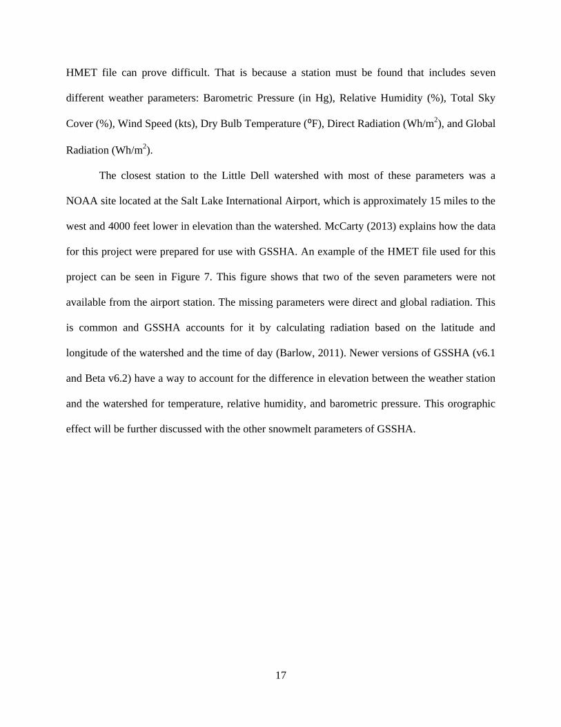
HMET file can prove difficult. That is because a station must be found that includes seven
different weather parameters: Barometric Pressure (in Hg), Relative Humidity (%), Total Sky
Cover (%), Wind Speed (kts), Dry Bulb Temperature (⁰F), Direct Radiation (Wh/m2), and Global
Radiation (Wh/m2).
The closest station to the Little Dell watershed with most of these parameters was a
NOAA site located at the Salt Lake International Airport, which is approximately 15 miles to the
west and 4000 feet lower in elevation than the watershed. McCarty (2013) explains how the data
for this project were prepared for use with GSSHA. An example of the HMET file used for this
project can be seen in Figure 7. This figure shows that two of the seven parameters were not
available from the airport station. The missing parameters were direct and global radiation. This
is common and GSSHA accounts for it by calculating radiation based on the latitude and
longitude of the watershed and the time of day (Barlow, 2011). Newer versions of GSSHA (v6.1
and Beta v6.2) have a way to account for the difference in elevation between the weather station
and the watershed for temperature, relative humidity, and barometric pressure. This orographic
effect will be further discussed with the other snowmelt parameters of GSSHA.

18
Figure 7: Portion of HMET file used for Little Dell model

19
3 SNOWMELT MODELING IN GSSHA
Snowmelt modeling is actively being researched and GSSHA model improvements are
continually updated and improved by ERDC. Part of that research was done for this project at
BYU by utilizing different snowmelt parameters and options and performing sensitivity analyses
to provide feedback to the GSSHA developers. The Little Dell watershed is one of several basins
where GSSHA snowmelt parameters are being tested and calibrated to observed outlet discharge
data. These models are also comparing the spatial and temporal distribution of snow
accumulation within a basin through orographic effects.
3.1 Snowmelt Analysis Options
As of this writing there are three different snowmelt simulation options: Temperature
Index, Energy Balance, and Hybrid Energy Balance. Each of these options requires their own set
of parameters, with the hybrid combining parameters from each of the other two. The Hybrid
Energy Balance option was selected for the Little Dell model for its relative accuracy and ease of
use.
3.1.1 Temperature Index
This analysis option uses an empirical method for calculating snowmelt. The method uses
a series of equations based on the fact that when the air temperature drops below 0 ⁰C the snow

20
pack will also drop in temperature which creates a temperature index that is a portion of the heat
deficit (Anderson, 1973). This method has long been tested and has produced results more
accurate when compared to the energy balance method (Debele et al., 2010). However, there are
more parameters associated with this option in GSSHA that are calibrated to a specific scenario
and can be difficult and time-consuming to calibrate to a different model.
3.1.2 Energy Balance
This option by itself is much simpler to set up by the user than the temperature index. It
uses the HMET data to distribute an energy budget to the entire model. In short, the amount of
heat available is applied to the snowpack and the amount of meltwater is calculated. While not as
accurate as the temperature index method, the energy balance can still provide good results with
much less time-intensive calibration efforts (Debele et al., 2010).
3.1.3 Hybrid Energy Balance
This method takes the energy balance method and includes the effects of heat deficits,
making it more accurate. The hybrid method is run on an hourly time step with the melt
generated distributed to other GSSHA model processes at the global variable time step (Follum,
2012b). This option was chosen for the Little Dell model because it has some calibration
parameters but is not nearly as difficult to calibrate as the temperature index method.
3.2 Continuous Frozen Ground Index
The effect of frozen soil is another area that ERDC has been seeking to improve on with
the latest versions of GSSHA (v6.1 and Beta v6.2). When the soil is frozen the runoff can be
dramatically increased due to little or no infiltration. For this reason researchers at ERDC

21
incorporated the Continuous Frozen Ground Index (CFGI) model that will run during a long-
term simulation of GSSHA (Molnau, 1983). The current release version of GSSHA (v6.1)
automatically runs the CFGI model, while the Beta version (v6.2) requires the CFGI card
included in the project file.
Version 6.2 allows the user to change the values of two CFGI parameters. The threshold
value for the calculated frozen soil index is set at 83.0 (⁰C-days), which are the sum of
temperatures for days below freezing and is reset to zero on any day when the temperature is
above freezing. Molnau (1983) found that when the index was over 83⁰C-days and a rainfall
event occurred, the runoff was almost always higher than would be expected if the ground were
not frozen. To change that value in GSSHA, the CFGI_INDEX ##.# card is added to the project
file along with the CFGI card with a value other than 83.0 next to it. Values higher than 83.0
will slow the thawing of the soil and values lower than 83.0 make the soil thaw faster and
produce less runoff. The other parameter is the thermal factor, K. To change the default value of
0.5, the CFGI_K #.# card is added to the project file. Molnau (1983) used three different values
for the thermal factor, K: 0.5 cm-1
for above freezing periods, 0.08 cm-1
for below freezing
periods, and 0.2 cm-1
as value in between that could be tested in all situations. All three were
tested in Little Dell model, with 0.5 achieving the best results. In general, K values higher than
0.5 increase the effect of snow and lower values decrease the effect (Smemoe, 2013).
3.3 Lateral Melt-Water Transport
One of the latest improvements to GSSHA has been the ability to route snowmelt through
the snow itself. McCarty (2013) utilized this new feature in an attempt to improve calibration
results to the Little Dell model. GSSHA previously ignored overland flow in the presence of

22
snow. The newly developed ROUTE_LAT_SNOW card for the project file allows melt-water
to move across the ground through the snow using methods developed by Colbeck (1974)
(Follum, 2012c).
3.4 Orographic Effects
The difference in elevation between the NOAA station where the HMET data for the
Little Dell model was retrieved and the watershed itself created a vast difference in temperature,
pressure, and relative humidity values. To account for this difference, Beta version 6.2 of
GSSHA has two methods to calculate the adiabatic lapse rate. The default in GSSHA calculates
the moist lapse rate using a derivation developed by Dr. David Tarboton from the University of
Utah (Follum, 2012e).
This is done by entering the card HMET_ELEV_GAGE ####.## in the project file,
along with the elevation of the gage where the HMET data was retrieved. The user can also
define a constant dry adiabatic lapse rate, for which the card YES_DALR_FLAG #.##### will
also be used. It should be noted that the units in v6.2 are ⁰C m-1
and are entered as a positive
value, unlike v6.1 which where the units are ⁰C km-1
and are entered as a negative value (Follum,
2012e).
As was mentioned, it can be difficult to find suitable HMET data for a long-term
simulation. As will be discussed further with the sensitivity analysis, temperature is a driving
factor to how GSSHA calculates the lapse rate. In the case of the Little Dell model, the
temperature differences between the watershed and the airport in the valley were inconsistent.
This could easily be the case for others who are forced to use HMET data far from the watershed
being modeled. For example, the Salt Lake Valley experiences extreme temperature inversions in

23
the winter due to pollution, the geography of the valley and direction of the wind currents. This
inversion actually makes the temperatures colder in the valley than several thousand feet higher
in the mountains, causing problems for a model used to predict snowmelt runoff where a lapse
rate is involved. An example of the temperatures used for the Little Dell model during one day of
such an inversion is found in Table 5. This example illustrates the danger of trusting the
collected HMET data, even with the use of an adiabatic lapse rate.
Table 5: Temperature inconsistencies from the HMET data used for the Little Dell GSSHA model
Salt Lake
International Airport
Little Dell
Watershed
Elevation 4230 ft. Elevation 8200 ft.
Date Time Temperature (⁰F) Temperature (⁰F)
1/29/2011 0:00 31 37
1/29/2011 1:00 32 36
1/29/2011 2:00 32 33
1/29/2011 3:00 32 36
1/29/2011 4:00 32 34
1/29/2011 5:00 31 35
1/29/2011 6:00 32 35
1/29/2011 7:00 32 34
1/29/2011 8:00 31 37
1/29/2011 9:00 31 38
1/29/2011 10:00 31 40
1/29/2011 11:00 31 40
1/29/2011 12:00 30 40
1/29/2011 13:00 30 40
1/29/2011 14:00 31 37
1/29/2011 15:00 31 36
1/29/2011 16:00 32 35
1/29/2011 17:00 32 35
1/29/2011 18:00 34 35
1/29/2011 19:00 37 36
1/29/2011 20:00 38 37
1/29/2011 21:00 36 36
1/29/2011 22:00 37 37
1/29/2011 23:00 34 36

24
3.5 Little Dell Snowmelt Parameters
As was previously mentioned, the Hybrid Energy Balance option was chosen for the
Little Dell model. Two parameters that are associated with all three melt methods and were
incorporated into the Little Dell model were the Snow Cover Factor and Base Temperature. The
two cards associated with both the Hybrid Energy Balance and Temperature Index methods used
were Snow Cover Thermal Gradient and Negative Melt Factor. The Lateral Melt-Water
Transport card and a combination of the Orographic Effects cards were also used to aid in
snowmelt modeling. A combination of all three of the Frozen Soil cards was also used. Many of
these cards were manually input into the project file, as GSSHA v6.2 is not yet supported by
WMS. A summary of all snow card inputs based on units and descriptions provided by Follum
(2012f) can be found in Table 6.
Table 6: Snowmelt parameter cards used in Little Dell model
Description Units Range Card
Hybrid Energy Balance - - default (no card required)
NWSRFS_SCF fraction 0.5-2.0 Snow Cover Factor (adjusts for mis-readings in the gage data)
SNOW_TEMP_BASE ⁰C 0-5 Base temperature at which melt begins in snow
SNOW_SWE_FILE m -
Outputs time-series snow water equivalent maps (similar to
DEP file)
NWSRFS_TIPM unitless 0.1-1.00 Snow Cover Thermal Gradient
NWSRFS_NMF mm/⁰C/6hr 0.00-1.00 Negative Melt Factor
ROUTE_LAT_SNOW - -
Simulates the lateral transport of melt-water through the
snow pack
HMET_ELEV_GAGE m -
Elevation of the gage site where temperature is measured.
Default value is the lowest elevation cell in your domain
YES_DALR_FLAG ⁰C/m-1 0.0045-0.00981
Dry adiabatic lapse rate of the area modeled. Best when
HMET_ELEV_GAGE card is present in Project File
CFGI - - Initiates CFGI model
CFGI_INDEX unitless 0-125
Allows user to set a numeric value for the threshold. Must
be used with CFGI card
CFGI_K cm-10.08,0.2,0.5
Allows user to specify snow thermal factor, K. Must be used
with CFGI card

25
4 CONCEPTUAL GROUNDWATER MODEL
Groundwater is an essential part of any hydrologic system but because of time scale,
ability to properly characterize, and integration with surface models is often difficult to model
and is therefore not included in many simulations focused on surface runoff. Within WMS there
is a way to set up a two-dimensional lateral groundwater flow simulation that solves the free
surface groundwater flow equations. However, for this project a newly developed conceptual
groundwater model (Pradhan, 2014) was used that is based on the Sacramento Soil Moisture
Accounting (SAC-SMA) model. It can simulate groundwater discharge to the stream without the
need to solve the full two-dimensional free surface groundwater flow equations, which helped
the model run much more quickly.
This model is comprised of two cards in the project file: the CONCEPTUAL_GW card
and the LINKS card. The CONCEPTUAL_GW card points GSSHA to a Params.con file that
contains all of the conceptual groundwater parameter values, which are shown in Error!
eference source not found.. The LINKS card points GSSHA to a Map.lik file containing an
index map that shows where the streams are to receive base flow. According to the GSSHA wiki,
the groundwater contributing area to a cell is assume to be the same as the contributing surface
water area of the cell (Pradhan, 2014).

26
Table 7: Conceptual groundwater parameter values
To set up a conceptual groundwater file, it is easiest to begin by creating the parameters
file with a text editor because as the writing this option is not supported in the WMS interface.
First, using the format shown in Figure 8, the user enters the desired parameter values and saves
them as a Params.con file and gives the file a distinct name, such as
“LittleDell_GW_Params.con”. The file is then saved within the project folder.
Figure 8: Example of Params.con file in project folder
The second step is to set up the Map.lik file. To do this, a Groundwater Boundary mask
(*.bnd file) needs to be created. This is preferably done using a copied “test” project folder that
can be discarded if needed. The GSSHA project file is opened in WMS and the Groundwater box
Parameter Minimun Initial Maximum Description
SLOW_MAX 1.0 75 150
maximum storage in slow aquifer
(mm)
FAST_MAX 1.0 500 1000
maximum storage in fast aquifer
(mm)
SLOW_RATE 0.0 0.01255 0.025 rate constant between 0-1
FAST_RATE 0.0 0.3 0.5 rate constant between 0-1
SLOW_CONTENT 0.0 0.5 1.0
initial content of the slow
reservoir, 0-1
FAST_CONTENT 0.0 0.5 1.0
initial content of the fast reservoir,
0-1
UNDERFLOW_PERCENT 0.0 0 1.0
percent of groundwater flow not
contributing to the stream

27
is checked in the Job Control Parameters. This will create a “Gw boundary” index map in the
project explorer. The groundwater “Edit parameters” button can be ignored. Next, all stream arcs
need to be selected. This can quickly be done using the Wizard in the “Define and Smooth
Streams” section. The “Select a stream branch” button is pressed and the stream arc closest to the
outlet is selected. This will select all stream arcs within the watershed. The “Set Selected Arc
Attributes” button is then pressed and all streams are set to “Flux river” in the “Groundwater
BC” column. Once these stream arcs are changed, the newly created index map needs to be
regenerated to reflect the changes. Once the index map is regenerated it should look similar to
Figure 9. The project file then needs to be saved.
Figure 9: Gw boundary index map after regeneration
Once the file is saved, the project folder is opened, where a newly created *.bnd file has
been created. The *.bnd file is opened in a text editor and will show the mask of “1” values

28
where the watershed boundary is and “4” values where the streams are located within the
watershed, as shown in Figure 10.
Figure 10: Groundwater boundary file
Taking great care not to alter the heading at the top of the file, the text editor is then used
to find and replace all “1” values in the project boundary with “0” values. All of “4” values are
replaced with values of “1”. This was done using Find and Replace tool within Notepad++, as
seen in Figure 11. The file is then saved as a Map.lik file and given a distinguishable name, such
as “LittleDell_GW_Map.lik”.
Figure 11: Example of Map.lik file

29
The two newly created files are then copied from the “test” folder into the project folder
being used for the actual model run. It is important that the project file contains the correct cards
and point to the two newly created folders. Figure 12 shows an example of what the cards would
look like in the project file using the example file names given in this paper. The conceptual
groundwater parameters can then be manually adjusted or calibrated stochastically.
Figure 12: Conceptual groundwater project file cards
The lengthy process described to set up the conceptual groundwater model could be
much simpler if it were added to the WMS interface. One option for this could be to add a
Conceptual Groundwater option in the Groundwater parameters within the Job Control
Parameters. That way the user would have the option to use the current two-dimensional
groundwater flow simulation or the simplified conceptual SAC-SMA groundwater model.


31
5 RESULTS AND DISCUSSION
As outlined in the previous sections, GSSHA has several different options to model
snowmelt. Not all of those methods were utilized for this project; in fact some are becoming
obsolete with the new developments to GSSHA. The focus here was on the Hybrid Energy
Balance along with its associated parameters that were then used to perform a sensitivity
analysis. This was done to help the GSSHA developers and then the WMS developers create
something that would allow other users to be successful in simulating snowmelt. McCarty (2013)
began testing the latest snowmelt tools in v6.2 of GSSHA in the Little Dell watershed.
Further sensitivity analyses of the snowmelt parameters for Little Dell are outlined here,
including the addition of a conceptual groundwater model. Progress was also made to calibrate
the model to observed streamflow data from a gaging station near the inlet to Little Dell
Reservoir, which is shown in Figure 13.

32
Figure 13: Observed discharge at outlet of Little Dell watershed
5.1 Matching the Runoff Timing
Figure 13 illustrates how in a snowmelt-dominated watershed, the vast majority of the
yearly discharge occurs during the space of only three to four months during the spring.
Matching the timing of the spring runoff in a model can be difficult. With the tools available at
the time, McCarty (2013) was able to match the basic size and shape of the observed hydrograph
but was unable to model the correct timing of the spring runoff. The model was starting to melt
the snow in August instead of April.
After many sensitivity analyses were performed for the different parameters and without
much success, I discovered that one parameter finally made a significant difference to the timing
of the runoff. By changing the Vegetation Radiation Coefficient, sometimes referred to as the
Vegetation Transmission Coefficient, the snowmelt runoff started and ended on roughly the

33
same dates as the observed data. This is one of the Evapotranspiration parameters found in the
*.cmt file and represents the amount of direct solar radiation that penetrates the vegetation
canopy and reaches the ground. The value is represented as a fraction and the range is 0.0 – 1.0
for each land use type.
In the initial model setup, the value for each land use had been set to 0.05, with the
assumption that this meant a 5% blockage of sun when in reality the actual meaning is that only
5% of the direct solar radiation was penetrating the vegetation canopy. This resulted in the major
delay in snowmelt timing. The values for all land uses were changed to 0.75, or 75% penetration,
which is more realistic for this type of vegetation (Chen et al., 2005). The result was that the
snow melted months earlier than in previous model runs. The results comparing the two
parameter values along with the observed discharge are shown in Figure 14.
Figure 14: Comparison of Vegetation Radiation Coefficient values

34
5.2 Lowering the Discharge Peaks
Once the snowmelt timing was within a reasonable range, more sensitivity analysis was
performed to lower the peaks of the runoff discharge. The modeled peaks were almost three
times as large as the observed data. Little progress in lowering the discharge peaks resulted after
adjusting snow, evapotranspiration, infiltration, and roughness parameters to realistic values.
This was when the inconsistency with the temperature from the HMET data was
observed that was discussed in Section 3.4. Temperatures from the Salt Lake International
Airport HMET data were compared to SNOTEL temperature data from a station located on the
edge of the watershed boundary at Lookout Peak. An average dry adiabatic lapse was calculated
for the recorded temperatures at the airport and at the SNOTEL site at the watershed during the
2011 water year. The average calculated value was a 2.0 ˚C decrease in air temperature per 1000-
foot rise in elevation, or 6.5 ˚C/km, which falls within the normal range. However, upon closer
inspection there were many periods of inconsistency between the temperatures at the two sites.
Considering those inconsistencies and the fact that the HMET data used was from a station 15
miles away and roughly 4000 feet lower in elevation, the decision was made to replace the
temperature column of the HMET file with the temperature values from the SNOTEL site. This
made a significant difference in the discharge peaks, as well as the overall shape of the
hydrograph, as the results show in Figure 15.

35
Figure 15: Comparison of airport and SNOTEL temperatures in HMET file
5.3 Increasing the Volume
With the snowmelt runoff timing and discharge peaks more comparable to the observed
discharge, the next step was to increase the volume of water. Up to this point the entire volume
of water infiltrated into the soil went unaccounted for in the GSSHA simulation model. The
addition of a groundwater model allowed for much of the infiltrated melt water to re-enter the
stream system. Initially, the runoff volume from model runs was much too high and presented
high discharge peaks. Through calibration, the discharge volume and peak heights of the
modeled hydrograph were brought down to levels reasonably close to that of the observed
hydrograph, as seen in Figure 16.

36
Figure 16: Comparison of Little Dell model with and without conceptual groundwater model
37
6 CONSLUSIONS
As the calibration process shows, it was difficult to match the timing, discharge peak
heights, and volume of the observed hydrograph at the Little Dell watershed. However, this
project has detailed how to overcome some of the major obstacles related to snowmelt modeling
in GSSHA. Most of the calibration and sensitivity analysis performed for this project was done
by running individual GSSHA models that ranged from 45-minute to 56-hour run times. Users
may wish to utilize the calibration tool within WMS or an outside stochastic run. For example,
Scott Christensen developed a Python script for the HT Condor software that utilized
approximately 130 computers to run 3215 GSSHA runs from this project. The runs included a
Latin Hypercube stochastic run using 5 different snowmelt parameters. While such an extensive
stochastic run is not necessarily recommended, it illustrates the possibilities of calibrating a
GSSHA model.
Much of this paper was written to provide feedback for the GSSHA developers and
guidance for the development of snowmelt simulations with GSSHA, including a good starting
place as to which project file cards to use as well as recommended starting values for the long-
term simulation and snowmelt parameters. The project file cards associated with snowmelt are
shown in Table 8 with a recommended starting value along with the sensitivity level of each
card.

38
Table 8: GSSHA snow cards with recommended starting values and sensitivity levels
A recommendation to the GSSHA developers would be to continue to research the CFGI
threshold and snow thermal factor values before recommending use of anything but the default
values. The GSSHA wiki provides little insight as to how the cards change how the model
freezes the ground. A sensitivity analysis performed on the two values did not significantly
change the results of the model until the parameters were adjusted to values that did not clearly
represent reality.
While the three snowmelt analysis options are available, it would be useful for users to
receive a recommendation on the GSSHA wiki as to which analysis works best under certain
scenarios or which analysis option is best for a beginning time user of the snowmelt options.
This recommendation could also be stated in the WMS interface as well as in the WMS tutorial
for snowmelt. The tutorial could mention which parameters are associated with each analysis
option and their respective ease of use and calibration.
Project File Card Sensitivity Impact Recommendation
Hybrid Energy Balance - Use
NWSRFS_SCF Medium 1
SNOW_TEMP_BASE High 0.25
SNOW_SWE_FILE - Use
NWSRFS_TIPM High 0.25
NWSRFS_NMF High 0.3
ROUTE_LAT_SNOW - Use
HMET_ELEV_GAGE High Use
YES_DALR_FLAG High Do Not Use
CFGI - Use
CFGI_INDEX Low Default Value
CFGI_K Low Default Value

39
The lateral routing card ROUTE_LAT_SNOW showed significantly better results and is
highly recommended for all future versions of GSSHA. The vertical flow option and the
SNOW_ DARCY and SNOW_REYNOLDS are still default in WMS, while users are directed
to use neither at this point by the GSSHA wiki. It is recommended that they either be updated or
removed from WMS.
The biggest struggle for modeling snowmelt for this project came with the HMET data
issue. It is recommended that the GSSHA wiki be updated to explain the scarcity of stations that
collect the required data for the HMET file. It is also recommended that the difference in these
data from a station far from the watershed may not be very effective in the model. I found that
replacing the temperature column with data from a station on the edge of the watershed and
adjusting the elevation of the HMET gage to that of the station of the new temperature data
produced much better results.
After performing a sensitivity analysis on the dry adiabatic lapse rate, it is recommended
that this option not be used. The default moist lapse rate performed much better. The WMS
interface does not make it clear that the moist rate is used when the “dry adiabatic lapse rate” box
is unchecked. Adding a dropdown box for “Moist” or “Dry” options would be helpful to clear up
any confusion, along with the word “recommended” in parentheses next to “Moist”. Before
WMS updates to a newer version of GSSHA, it would also be helpful to change the lapse rate
units of ⁰C/m back to ⁰C/km. A clarification is needed as to whether the value is entered as a
positive or a negative on both the GSSHA wiki as well as the WMS interface.
The conceptual groundwater model was extremely useful for increasing the volume of the
observed discharge and accounting for infiltrated meltwater. It was much easier to use and adjust
the parameters once it was set up as compared to the two-dimensional groundwater simulation,

40
especially with limited information about the watershed aquifer. It would be very helpful for the
WMS developers to incorporate this option into the groundwater parameters. It would involve
creating an index map similar to the *.bnd file and options to adjust the seven different
parameters.
The ultimate goal of providing the BYU researchers with a snowmelt model to use for
testing web applications has been met. However, considering the complexity of adjusting the
snowmelt parameters for v6.2 and the rate at which the GSSHA snowmelt processes are being
developed, it would be hard to recommend this process to less experienced GSSHA users. At the
current rate, researchers at ERDC, with help from projects like this, will soon have v6.2 ready for
use in WMS. At that point, the process of creating a simulation including snowmelt in GSSHA
will be simpler and be more easily achieved in CI-WATER applications.

41
REFERENCES
Ames, D. P., Horsburgh, J.S., Cao, Y., Kadlec, J., Whiteaker, T., and Valentine, D. (2012).
HydroDesktop: Web Services-Based Software for Hydrologic Data Discovery,
Download, Visualization, and Analysis. Environmental Modelling & Software, 37, 146-
156.
Anderson, E. A. (1973). National Weather Service river Forecast System - Snow Accumulation
and Ablation ModelNWS_HYDRO-17 (Vol. Tech. Memo). Silver Springs, MD: National
Oceanographic and Atmospheric Administration.
Aquaveo, L. (2012). GSSHA - Applications - Long Term Simulations in GSSHA Retrieved 16
July 2014, from http://wmstutorials-9.1.aquaveo.com/52%20Gssha-Applications-
LongTerm.pdf
Barlow, C. (2011, 31 January 2011). Long-term Simulations: Hydrometeorological data
Retrieved 17 July 2014, from http://www.gsshawiki.com/Long-
term_Simulations:Hydrometeorological_data
Biggs, T. W., Whitaker, T. M. (2012). Critical elevation zones of snowmelt during peak
discharges in a mountain river basin. Journal of Hydrology, 438, 52-65.
Chen, J. M., Menges, C. H., & Leblanc, S. G. (2005). Global mapping of foliage clumping index
using multi-angular satellite data. Remote Sensing of Environment, 97(4), 447-457. doi:
http://dx.doi.org/10.1016/j.rse.2005.05.003
CI-WATER. (2012). CI-WATER A Utah-Wyoming Cyberinfrastructure Water Modeling
Collaboration Retrieved June 15, 2014, from ci-water.org
Colbeck, S. C. (1974). Water flow through snow overlying an impermeable boundary : Figs,
14R. Water resources research, V10, Feb. 1974, P119–123. International Journal of Rock
Mechanics and Mining Sciences & Geomechanics Abstracts, 11(10), 202. doi:
http://dx.doi.org/10.1016/0148-9062(74)91175-9
Debele, B., Srinivasan, R., & Gosain, A. K. (2010). Comparison of Process-Based and
Temperature-Index Snowmelt Modeling in SWAT. Water Resources Management, 24(6),
1065-1088. doi: 10.1007/s11269-009-9486-2
Downer, C. W. (2011, 10 April 2014). Information for "Gridded Surface Subsurface
Hydrological Analysis" Retrieved 16 July 2014, 2014, from
http://gsshawiki.com/Main_Page

42
Downer, C. W., & Ogden, F. L. (2004). GSSHA: Model To Simulate Diverse Stream Flow
Producing Processes. [Article]. Journal of Hydrologic Engineering, 9(3), 161-174. doi:
10.1061/(asce)1084-0699(2004)9:3(161)
Ellis, C. R., Pomeroy, J. W., & Link, T. E. (2013). Modeling increases in snowmelt yield and
desynchronization resulting from forest gap-thinning treatments in a northern mountain
headwater basin. Water Resources Research, 49(2), 936-949. doi: 10.1002/wrcr.20089
Follum, M. (2012a, 21 December 2012). Distributed HMET Data Retrieved 17 July 2014, from
http://www.gsshawiki.com/Distributed_HMET_Data
Follum, M. (2012b). Hybrid Energy Balance Retrieved 17 July 2014, from
http://gsshawiki.com/Hybrid_Energy_Balance
Follum, M. (2012c). Lateral MWT Retrieved 17 July 2014, from
http://gsshawiki.com/Lateral_MWT
Follum, M. (2012d). Old Snow Page Retrieved 28 July 2014, from
http://gsshawiki.com/Old_Snow_Page
Follum, M. (2012e). Orographic Effects Retrieved 17 July 2014, from
http://gsshawiki.com/Orographic_Effects
Follum, M. (2012f, 28 December 2013). Snow Card Inputs - Optional Retrieved 17 July 2014,
from http://gsshawiki.com/Snow_Card_Inputs_-_Optional
Leavesley, G. H. (1989). Problems of snowmelt runoff modelling for a variety of physiographic
and climatic conditions. Hydrological Sciences Journal, 34(6), 617-634. doi:
10.1080/02626668909491371
Lowry, C. S., Deems, J. S., Loheide Ii, S. P., & Lundquist, J. D. (2010). Linking snowmelt-
derived fluxes and groundwater flow in a high elevation meadow system, Sierra Nevada
Mountains, California. Hydrological Processes, 24(20), 2821-2833. doi:
10.1002/hyp.7714
McCarty, J. A. (2013). Long-term Simulation in Parley's Canyon Using GSSHA. Master of
Science, Brigham Young University, Provo, UT.
Molnau, M., Bissell, V. C. (1983). A Continuous Frozen Ground Index for Flood Forecasting. In
N. University of Idaho (Ed.), (Vol. 734-83, pp. 109-119). Vancouver, WA: Western
Snow Conference.
Peterson, T. C., and Vose, R. S. (1997). An overview of the Global Historical Climatology
Network temperature data base. Bulletin of the American Meteorological Society, 78(12),
2837-2849.
Pradhan, N. W. (2014). Conceptual Groundwater: Conceptual Groundwater Retrieved 18 July
2014, from http://gsshawiki.com/Conceptual_Groundwater:Conceptual_Groundwater
Raleigh, M. S., & Lundquist, J. D. (2012). Comparing and combining SWE estimates from the
SNOW-17 model using PRISM and SWE reconstruction. Water Resources Research,
48(1), W01506. doi: 10.1029/2011wr010542

43
Shaw, E. (2008, 17 February 2014). WMS: Introduction to WMS Retrieved 15 July 2014, from
http://www.xmswiki.com/xms/index.php?title=WMS:Introduction_to_WMS&action=edi
t
Smemoe, C. (2013, 7 February 2014). Frozen Soil: Frozen Soil Retrieved 17 July 2014, from
http://www.gsshawiki.com/Frozen_Soil:Frozen_Soil
USACE. (2014). Coastal & Hydraulics Laboratory Retrieved July 14, 2014, from
http://chl.erdc.usace.army.mil/gssha