mitigation site report madison cave isopod · madison cave isopod site mitigation report december...
TRANSCRIPT
Madison Cave Isopod Site Mitigation Report
December 2010
1
Determining Mitigation Needs for NiSource Natural Gas Transmission Facilities ‐ Implementation of the Multi‐Species
Habitat Conservation Plan (MSHCP)
Section 6 Cooperative Endangered Species Conservation Fund Grant (IDFW Subtask 2.2)
Prepared by The Conservation Fund DECEMBER 2010
Mitigation Site Report Madison Cave Isopod

Madison Cave Isopod Site Mitigation Report
December 2010
2
MADISON CAVE ISOPOD MITIGATION SITE REPORT TABLE OF CONTENTS Mitigation Site Report Summary ..................................................... Error! Bookmark not defined. Potential Madison Cave Isopod Mitigation Opportunity Summary Table ..................................... 5 Madison Cave Isopod Decision Tree ............................................................................................... 9 Madison Cave Isopod Tree Logic & Criteria Weights .................................................................... 10 Madison Cave Isopod Criteria Descriptions & Values .................................................................. 13 GeoConcepts Assessment of Karst Terrain Report ....................................................................... 24 State Wildlife Actions Plan ............................................................................................................ 25 Virginia ....................................................................................................................................... 25 West Virginia ............................................................................................................................. 25

Madison Cave Isopod Site Mitigation Report
December 2010
3
NiSource MSHCP Take Species Requiring Mitigation
Bog Turtle Clubshell Fanshell
Indiana Bat James Spinymussel Madison Cave Isopod Nashville Crayfish Northern Riffleshell
Sheepnose
Mitigation Site Report Summary The key task of the NiSource Multi‐Species Habitat Conservation Plan (MSHCP) Section 6 grant is to identify potential mitigation opportunities for take species outlined in the MSHCP. The Conservation Fund (the Fund), in consultation with the US Fish and Wildlife Service (USFWS), NiSource, and state natural resource agencies, has prepared customized mitigation site reports, organized by species that provide selection criteria and an initial list of potential mitigation project opportunities that are likely to meet the requirements outlined in the MSHCP. Additional information on individual projects will be required at the time of mitigation need as outlined in the Mitigation Proposal Requirements section of the MSHCP. Whether a mitigation proposal can be funded will depend on a number of factors, including but not limited to the species affected, the location of the mitigation activities compared to the location of the species impacts, the cost of the mitigation proposal, whether the proposal satisfies the mitigation proposal criteria, and the scientific justification for the mitigation proposal. This species report is a helpful resource in preparing the future applications for mitigation funding and should be used in conjunction with the Decision Support Framework for Evaluating and Ranking Mitigation Sites report. Mitigation Project Criteria Each take species has a set of project selection criteria that will be used to help evaluate and rank potential mitigation projects. The MSHCP currently includes nine take species where potential mitigation projects meeting specific requirements will need to be identified over the 50‐year timeframe of the MSHCP (see table). The Fund generated an initial set of mitigation project selection criteria for each species based upon an analysis of the draft MSHCP. These criteria were reviewed and refined in detail during a series of webinars held by the Fund, NiSource, and USFWS in spring 2010. These criteria were then presented to the states during focus group meetings in summer 2010 where additional enhancements were made. The Fund synthesized the comments from the states in September 2010 and organized the criteria for each species into a hierarchical structure known as a ‘decision tree’. Each decision tree evaluates to what extent a potential mitigation project meets the particular take species mitigation needs and desires (including habitat quality, location, likely protection in perpetuity, and protection of other listed species) as well as how it supports the green infrastructure network design, advances state and regional planning goals, and leverages other financial and partnership resources. The Fund has included a copy of the decision tree as a reference in this report. Each criterion spans a range of characteristics from most to least suitable in terms of meeting species mitigation requirements. Where each project falls within this range is represented numerically on a standard scale from 0‐100 that describes how well it satisfies that particular criteria (100 being the highest). In addition to the score for each criterion, weights are assigned relative to other criteria within its ‘branch of the tree’ since some factors are more important than others in evaluating a potential project. In addition, criteria have a ‘logic structure’ that designates them as mandatory, sufficient, or desired based on their contribution to species protection. The Fund has included descriptions of the criteria and their values as reference in this report. The project selection criteria provide an applicant

Madison Cave Isopod Site Mitigation Report
December 2010
4
with insight into project characteristics that make them more attractive for mitigation funding and hopefully will lead to well prepared applications that are responsive to the articulated goals of the mitigation effort. The design of the decision trees is based on a state‐of‐the‐art method known as ‘logic scoring of preference’ (LSP) to ensure that all criteria and weightings are designed to reflect fundamental properties of human reasoning and ensure that the benefits calculated accurately reflect the desired intent of decision makers (Dujmović, 2007). Dr. Jozo Dujmović, one of the world’s pioneers in the use of LSP for decision making, has designed a customized desktop software package (ISEE) and a web‐based application (LSPWeb) to support the ongoing refinement of the species decision trees as the MSHCP begins to be implemented in 2011. Instructions on the use of LSP software are found within the ISEE Users Manual‐ Integrated System Evaluation Environment V1.1. For web applications, refer to the LSP Methods for Evaluation over the Internet V1. Although the details of the application review process are not firm at this time, it is likely that the application reviewer(s) would enter the criteria values into the LSP software for each potential mitigation project. Next, the LSP software generates a numerical score on a 100‐point scale that represents the percent satisfaction that the project meets the decision tree criteria. The ISEE desktop application is the tool that ensures the criterion scores, weights, and logic structure are structured properly and follow the scientifically rigorous techniques of the LSP method. A project’s percent satisfaction, when combined with the costs of implementing the project, can be used to help evaluate and rank potential mitigation projects. When trying to select a single project to meet mitigation requirements, the LSPWeb application streamlines the selection process and helps clarify the tradeoffs involving benefits and costs for potential projects. In situations where a large number of projects need to be selected concurrently within a relatively fixed budget constraint, tools using the concept of optimization are most suitable for helping to select multiple projects at a time. The Fund has collaborated with Dr. Kent Messer from the University of Delaware to develop the Optimization Decision Support Tool (ODST). The ODST is an Excel™ based application that allows users to evaluate mitigation opportunities based on a variety of evaluation techniques: (1) identifying an optimal set of mitigation projects within a fixed budget constraint, (2) exploring the relative cost effectiveness of mitigation projects and selecting the portfolio with the highest benefit: cost ratio, and/or (3) identifying the minimum cost required to achieve a defined benefit level. The details of the use of the software application are covered in the user manual “Optimization Decision Support Tool Reference Guide –Lite Version. All mitigation project selection will be governed by the decision making process outlined in the MSHCP. A final MSHCP will not be available before the end of the Section 6 grant project. The weights and logic structure outlined in the enclosed decision trees are likely to be adjusted in the future by USFWS and NiSource, in consultation with the states. With the above caveats in mind, this species mitigation site report summarizes each state’s Wildlife Action Plan recommendations, Maxent models and mitigation opportunities; and provides a true landscape scale snap shot of the alternatives. This document hopefully will serve as a desk reference for mitigation needs and opportunities for the Madison cave isopod within Virginia.

Madison Cave Isopod Site Mitigation Report
December 2010
5
Potential Madison Cave Isopod Mitigation Opportunity Summary Table The following table summarizes potential mitigation site opportunities for the Madison Cave Isopod. The bulk of sites were contributed by state agency staff at two outreach meetings held in 2008 and 2010. Each site represents a general location for a potential mitigation opportunity, but the features in the associated GIS layer are not accurate to the parcel scale.
ID Opportunity Location
VAMI2 Protect known population Cave Hill, but other opportunities available
VAMI3 Protect known population Front Royal Area, Brother Dave's (Fishnet)
VAMI1 Protect known population Limekiln Cave
VAMI4 Protect known population Massanutten Caves
VAMI5 Protect known population 3‐D Maze (Mad Devil)

Madison Cave Isopod Site Mitigation Report
December 2010
6
Map 1 – Madison Cave Isopod Opportunities and Geologic Units

Madison Cave Isopod Site Mitigation Report
December 2010
7
Map 1 – Madison Cave Isopod Opportunities and the Green Infrastructure Network

Madison Cave Isopod Site Mitigation Report
December 2010
8
Map 3 – Madison Cave Isopod Opportunities and Protected Lands

Madison Cave Isopod Site Mitigation Report
December 2010
9
Madison Cave Isopod Decision Tree
1 Madison Cave Isopod Mitigation Projects 11 Habitat Mitigation Needs 111 Mandatory Requirements 1111 Mitigation Units 1112 Site Assessment 11121 Parcel Size 11122 Scope of Protection 1113 Physical Conditions 11131 Hydrologic Linkages 11132 Karst Surface Drainage 11133 Karst Feature Density 11134 Vegetative Cover 1114 Species Occurrence 11141 Isopod Density 11142 Population EO Rank 1115 Project Location
112 Desired Characteristics 1121 Protection in Perpetuity 11211 Point & Nonpoint Pollution Risk 11212 Sedimentation Risk 11213 Human Disturbance Risk 11214 Water Withdrawal Risk 11215 Project Monitoring 1122 Listed Species Protection 11221 NiSource MSHCP Take Species 11222 Federal & State Listed Species
12 Strategic Conservation Goals 121 Green Infrastructure Network 122 Adopted Plans & Leverage 1221 State Wildlife Action Plans 1222 Conservation Planning 1223 Collaboration KEY Bold ‐ Criteria where values are directly input into Decision Tree Software Italic ‐ Categories with logic structure (i.e. mandatory/desired, simultaneity, replaceability)

Madison Cave Isopod Site Mitigation Report
December 2010
10
Madison Cave Isopod Tree Logic & Criteria Weights 1 Madison Cave Isopod Mitigation Projects [CPA ‐20+15] 11 MANDATORY Take Species Habitat Mitigation Requirements 12 DESIRED Other Conservation Goals The DESIRED input cannot compensate the absence of MANDATORY input, but the MANDATORY input can significantly compensate the absence or low value of the DESIRED input. There is a 20% penalty for a low DESIRED value and a 15% reward for a high DESIRED value. This is known as conjunctive partial absorption (CPA). 11 Habitat Mitigation Needs [CPA ‐25+20] 111 MANDATORY Requirements 112 DESIRED Characteristics The DESIRED input cannot compensate the absence of MANDATORY input, but the MANDATORY input can significantly compensate the absence or low value of the DESIRED input. There is a 25% penalty for a low DESIRED value and a 20% reward for a high DESIRED value. This is known as conjunctive partial absorption (CPA). 111 Mandatory Requirements [C+‐ Medium‐strong simultaneity] 1111 Mitigation Units – 30% 1112 Site Assessment – 20% 1113 Physical Conditions – 20% 1114 Species Occurrence – 15% 1115 Project Location – 15% In medium‐strong simultaneity, all inputs must be to some extent simultaneously satisfied. Any zero input yields a zero output. This is known as hard partial conjunction (HPC), which is used to model mandatory requirements. Percentages correspond to the relative weights of each criterion within this branch of the tree. 1112 Site Assessment [C‐+ Medium‐weak simultaneity] 11121 Parcel Size – 40% 11122 Scope of Protection – 60% In medium‐weak simultaneity, all inputs should be to some extent simultaneously satisfied. Any zero input yields a zero output. This is known as hard partial conjunction (HPC), which is used to model mandatory requirements. Percentages correspond to the relative weights of each criterion within this branch of the tree.

Madison Cave Isopod Site Mitigation Report
December 2010
11
1113 Physical Conditions [C‐+ Medium‐weak simultaneity] 11131 Hydrologic Linkages – 20% 11132 Karst Surface Drainage – 25% 11133 Karst Feature Density – 40% 11134 Vegetative Cover – 15% In medium‐weak simultaneity, all inputs should be to some extent simultaneously satisfied. A zero input does not necessarily yield a zero output. This is known as soft partial conjunction (SPC), which is used to model non‐mandatory requirements. Percentages correspond to the relative weights of each criterion within this branch of the tree. 1114 Species Occurrence [C‐+ Medium‐weak simultaneity] 11141 Isopod Density – 50% 11142 Population EO Rank – 50% In medium‐weak simultaneity, all inputs should be to some extent simultaneously satisfied. Any zero input yields a zero output. This is known as hard partial conjunction (HPC), which is used to model mandatory requirements. Percentages correspond to the relative weights of each criterion within this branch of the tree. 112 Desired Characteristics [C‐‐ Very‐weak simultaneity] 1121 Protection in Perpetuity – 60% 1122 Listed Species Protection – 40% In very weak simultaneity, all inputs should be to some extent simultaneously satisfied. A zero input does not necessarily yield a zero output. This is known as soft partial conjunction (SPC), which is used to model non‐mandatory requirements. Percentages correspond to the relative weights of each criterion within this branch of the tree. 1121 Likely Protection in Perpetuity [C‐+ Medium‐weak simultaneity] 11211 Point & Nonpoint Pollution Risk – 20% 11212 Sedimentation Risk – 20% 11213 Human Disturbance Risk – 25% 11214 Water Withdrawal Risk – 20% 11215 Project Monitoring – 15% In medium‐weak simultaneity, all inputs should be to some extent simultaneously satisfied. Any zero input yields a zero output. This is known as hard partial conjunction (HPC), which is used to model mandatory requirements. Percentages correspond to the relative weights of each criterion within this branch of the tree. 1122 Protection of Other Listed Species [DA Strong replaceability] 11221 NiSource MSHCP Take Species – 75%

Madison Cave Isopod Site Mitigation Report
December 2010
12
11222 Other Federal and State Listed Species – 25% In strong replaceability, each input can be used to completely compensate the lack of remaining inputs. This is known as hard partial disjunction (HPD), which is used to model sufficient conditions. Percentages correspond to the relative weights of each criterion within this branch of the tree. 12 Other Conservation Goals [C‐ Weak simultaneity 65/35] 121 Support for Green Infrastructure Goals – 65% 122 Planning Goals and Leverage Opportunities ‐35% In weak simultaneity, all inputs should be to some extent simultaneously satisfied. A zero input does not necessarily yield a zero output. This is known as soft partial conjunction (SPC), which is used to model non‐mandatory requirements. Percentages correspond to the relative weights of each criterion within this branch of the tree. 122 Planning Goals and Leverage Opportunities [DA Strong replaceability 30/20/50] 1221 State Wildlife Action Plans – 30% 1222 Other State and Regional Plans – 20% 1223 In‐Kind Support – 50% In strong replaceability, each input can be used to completely compensate the lack of remaining inputs. This is known as hard partial disjunction (HPD), which is used to model sufficient conditions. Percentages correspond to the relative weights of each criterion within this branch of the tree.

Madison Cave Isopod Site Mitigation Report
December 2010
13
Madison Cave Isopod Criteria Descriptions & Values 1 Madison Cave Isopod Mitigation Projects 11 Habitat Mitigation Needs 111 Mandatory Requirements 1111 Mitigation Units – (30%)
1111 Mitigation Units [0,1]
Value % Mitigation required for the Madison Cave Isopod is based on the number of viable populations protected. There will likely be one per project. This criterion represents a mandatory requirement.
0 1
0 100
1 Madison Cave Isopod Mitigation Projects 11 Habitat Mitigation Needs 111 Mandatory Requirements
1112 Site Assessment (20%) 11121 Parcel Size – 40% 11122 Scope of Protection – 60%
11121 Parcel Size [0,75]
Value % FWS, NiSource, and States have determined that the size of parcel (in acres) is an important factor for evaluating potential mitigation projects. This criterion represents a mandatory requirement.
0 75
0 100
11122 Scope of Protection [0,100]
Value % FWS, NiSource, and the States have determined suitability based upon proportion of conservation site protected (in percent). This criterion represents a mandatory requirement.
0 100
0 100

Madison Cave Isopod Site Mitigation Report
December 2010
14
1 Madison Cave Isopod Mitigation Projects 11 Habitat Mitigation Needs 111 Mandatory Requirements
1113 Physical Conditions (20%) 11131 Hydrologic Linkages – 20% 11132 Karst Surface Drainage – 25% 11133 Karst Feature Density – 40% 11134 Vegetative Cover – 15%
11131 Hydrologic Linkages [0,1]
Value % FWS, NiSource, and the states have determined that hydrologic linkage is important for a potential mitigation project. Is the site linked hydrologically to occurrences of the Madison Cave Isopod? 1 = Yes 0 = No This criterion represents a mandatory requirement.
0 1
0 100
11132 Karst Surface Drainage [0,100]
Value % FWS, NiSource, and the States have determined the area of site that drains to karst (in percent) is an important factor for a potential mitigation project. This criterion represents a mandatory requirement.
0 100
0 100
11133 Karst Feature Density [0,10]
Value % FWS, NiSource, and the States have determined suitability based upon density of karst features (number per square mile) at the mitigation project location. This criterion represents a mandatory requirement.
0 2 5 10
0 50 75 100
11134 Vegetative Cover [0,100]
Value % FWS, NiSource, and the States have determined suitability based upon area of site covered by forest 0 0

Madison Cave Isopod Site Mitigation Report
December 2010
15
100
100
(in percent) is an important consideration for a potential mitigation project. This criterion represents a mandatory requirement.
1 Madison Cave Isopod Mitigation Projects 11 Habitat Mitigation Needs 111 Mandatory Requirements
1114 Species Occurrence (15%) 11141 Isopod Density – 50% 11142 Population EO Rank – 50%
11141 Isopod Density [0,2]
Value % FWS, NiSource, and the States have determined suitability based upon isopod density is an important factors for a mitigation project location. Protocols to be developed or adopted to make assessment. 2 = High 1 = Medium 0 = Low This criterion represents a mandatory requirement.
0 1 2
0 50 100
11142 Population EO Rank [0,2]
Value % FWS, NiSource, and the States have determined suitability based upon the Element occurrence rank for the isopod population at the site. 2 = Rank of "A" 1 = Rank of "B" 0 = Rank of "C" or lower This criterion represents a mandatory requirement.
0 2
0 100

Madison Cave Isopod Site Mitigation Report
December 2010
16
1 Madison Cave Isopod Mitigation Projects 11 Habitat Mitigation Needs 111 Mandatory Requirements 1115 Project Location – 15%
1115 Project Location [0,4]
Value % Suitable project locations will be evaluating by Wil Orndorff at VA Game & Inland Fisheries. 4 = Highly Suitable 3 = Suitable 2 = Somewhat Suitable 1 = Likely Unsuitable 0 = Not suitable This criterion represents a mandatory requirement.
0 4
0 100
1 Madison Cave Isopod Mitigation Projects 11 Habitat Mitigation Needs 112 Desired Characteristics 1121 Protection in Perpetuity (60%) 11211 Point & Nonpoint Pollution Risk – 20% 11212 Sedimentation Risk – 20% 11213 Human Disturbance Risk – 25% 11214 Water Withdrawal Risk – 20% 11215 Project Monitoring – 15%
11211 Point & Nonpoint Pollution Risk [0,4]
Value % FWS, NiSource, and the States have determined suitability based upon the risk of upstream point and nonpoint source runoff from activities near a mitigation project location. Potential magnitude of nearby, upstream point and nonpoint source runoff, which may include, but is not limited to sewage treatment, forestry and agricultural operations, acid mine drainage, energy development (e.g. coal), toxic chemical spills and contamination or other pollution sources within the site:
0 4
0 100
Madison Cave Isopod Site Mitigation Report
December 2010
17
4 = None 3 = Low 2 = Medium 1 = High 0 = Very High This criterion is not a mandatory requirement.
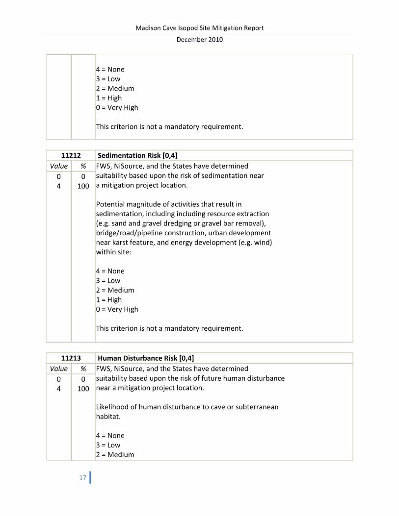
11212 Sedimentation Risk [0,4]
Value % FWS, NiSource, and the States have determined suitability based upon the risk of sedimentation near a mitigation project location. Potential magnitude of activities that result in sedimentation, including including resource extraction (e.g. sand and gravel dredging or gravel bar removal), bridge/road/pipeline construction, urban development near karst feature, and energy development (e.g. wind) within site: 4 = None 3 = Low 2 = Medium 1 = High 0 = Very High This criterion is not a mandatory requirement.
0 4
0 100
11213 Human Disturbance Risk [0,4]
Value % FWS, NiSource, and the States have determined suitability based upon the risk of future human disturbance near a mitigation project location. Likelihood of human disturbance to cave or subterranean habitat. 4 = None 3 = Low 2 = Medium
0 4
0 100

Madison Cave Isopod Site Mitigation Report
December 2010
18
1 = High 0 = Very High This criterion is not a mandatory requirement.
11214 Water Withdrawal Risk [0,4]
Value % FWS, NiSource, and the States have determined suitability based upon the risk of groundwater withdrawl near a mitigation project location. Likelihood of significant groundwater withdrawal: 4 = None 3 = Low 2 = Medium 1 = High 0 = Very High This criterion is not a mandatory requirement.
0 4
0 100
11215 Project Monitoring [0,4]
Value % FWS, NiSource, and the States have determined suitability based upon the quality and efficacy of the monitoring program for a mitigation project. An excellent monitoring program would be multi‐year, require dual phase qualitative and quantitative sampling, and have an experienced monitoring team. 4 = Excellent 3 = Very Good 2 = Good 1 = Fair 0 = Poor This criterion is not a mandatory requirement.
0 4
0 100

Madison Cave Isopod Site Mitigation Report
December 2010
19
1 Madison Cave Isopod Mitigation Projects 11 Habitat Mitigation Needs 112 Desired Characteristics 1122 Listed Species Protection (40%) 11221 NiSource MSHCP Take Species – 75% 11222 Federal & State Listed Species – 25%
11221 NiSource MSHCP Take Species [0,3]
Value % FWS, NiSource, and the States have determined suitability based upon where the potential mitigation project supports protection of other NiSource MSHCP take species. Evaluated as the number of supported species. This criterion is not a mandatory requirement.
0 1 3
0 80 100
11222 Federal & State Listed Species [0,3]
Value % FWS, NiSource, and the States have determined suitability based upon where the potential mitigation project supports protection of federally listed threatened or endangered species, G1‐G3 species, GCN species, or state listed rare habitats or communities not included as take species within the MSHCP: Evaluated as the number of species (0‐3). This criterion is not a mandatory requirement.
0 1 3
0 80 100
1 Madison Cave Isopod Mitigation Projects 12 Strategic Conservation Goals 121 Green Infrastructure Network (65%)
121 Green Infrastructure Network [0,5]
Value % Characterized green infrastructure network. The value is generated by combining the following GIS layers: GI hubs (2 points), GI core forest (1), GI aquatic areas (1), GI wetlands (1) and GI corridors (1). The maximum number of points is 6, and 5 points is
0 1 2 3 4
0 50 70 80 90

Madison Cave Isopod Site Mitigation Report
December 2010
20
5
100
sufficient for complete satisfaction of this criterion. The value is a proxy for the contribution of the mitigation project to the protection of an interconnected network of natural resource lands. This criterion is not a mandatory requirement.
1 Madison Cave Isopod Mitigation Projects 12 Strategic Conservation Goals 122 Adopted Plans & Leverage (35%) 1221 State Wildlife Action Plans – 30% 1222 Conservation Planning – 20% 1223 Collaboration – 50%
1221 State Wildlife Action Plans [0,4]
Value % How well does the potential mitigation project support the adopted State Wildlife Action Plan. Evaluated as the number of supported actions/plans. The weights and logic structure may be adjusted by FWS and NiSource in the future. This criterion is not a mandatory requirement.
0 1 3 4
0 50 90 100
1222 Conservation Planning [0,4]
Value % Does the potential mitigation project support other state and regional planning efforts? Plans may include, but are not limited to: Coastal and Estuarine Land Conservation Plan State Wetlands Plan State Greenways and Trails Plan State Forestry Plan Climate Action Plans Statewide Comprehensive Recreation Plan State GAP Analysis, Forest Legacy Needs Assessment, Natural Areas Statewide Plan Nature Conservancy Eco‐regional Plans/Assessments
0 1 3 4
0 50 90 100

Madison Cave Isopod Site Mitigation Report
December 2010
21
Eastern Brook Trout Joint Venture Report Ohio River Valley Ecosystem Mollusk Conservation Plan Ohio River Islands National Wildlife Refuge CCR Partners in Flight North American Conservation Plan Chesapeake Bay Health and Restoration Assessment Evaluated as the number of supported actions/plans. This criterion is not a mandatory requirement.
1223 Collaboration [0,100]
Value % How well does the potential mitigation project leverage in‐kind resources for restoration, monitoring, stewardship, management, and education/interpretation? Projects that bring additional resources will receive additional consideration when compared with projects that rely solely on funding from the project application. Value range is 0‐100% based on the level of collaboration included in the mitigation project proposal. This criterion is not a mandatory requirement.
0 100
0 100

Madison Cave Isopod Site Mitigation Report
December 2010
22
Evaluated Mitigation Opportunities (Wil Orndorff)

Madison Cave Isopod Site Mitigation Report
December 2010
23

Madison Cave Isopod Site Mitigation Report
December 2010
24
GeoConcepts Assessment of Karst Terrain Report
ASSESMENT OF KARST TERRAIN IN SUPPORT OF MADISON CAVE ISOPOD (ANTROLANA LIRA) POPULATION ESTIMATES
The cirolanid isopod, Antrolana lira, commonly known as the Madison Cave Isopod, is endemic to the phreatic karst aquifer of the Shenandoah Valley of Virginia. Originally thought to be restricted to the type locality, Madison Cave in Augusta County, Virginia, the isopod has now been found at numerous localities located in the phreatic karst aquifers of Lower Paleozoic carbonate rocks dating from Cambrian through Middle Ordovician in age. Designated a threatened species by the Department of the Interior, Fish and Wildlife Service on November 3, 1982, A. lira has been included in the Multi‐Species Habitat Conservation Plan for the NiSource Gas Transmission and Storage Pipeline. The habitat of A. lira is connected to the surface through the epikarst network of solution‐enlarged conduits, in particular caves and “open‐throat” sinkholes, which allow the unfiltered incursion of surface water into the phreatic aquifer. The connectivity and extent of the epikarst and phreatic zones is poorly understood within the range of A. lira, and effective survey methods have not been developed for the taxon or its habitat. Thus, the Fish and Wildlife Service assumes the presence of the isopod if any project is within suitable habitat, and requires the delineation of karst terrain to develop population estimates, and minimize impact to the threatened species. GeoConcepts Engineering has conducted a survey of karst features within the inferred range of A. lira, including an “impact area” that encompasses the NiSource Pipeline right of way, and a more extensive “covered lands” area which extends approximately 1/2‐mile from either side of the right of way and includes the impact area. In all, 227 karst‐related closed depressions, and 33 caves, have been identified within the covered lands. Of these, 114 closed depressions and 22 caves fall within the known range of the isopod, with the remainder occurring within potential geological habitat where the taxon has yet to be collected. Five (5) sites have been identified as presenting the most imminent threat to the isopod’s habitat, these being:
1. A large closed depression with exposed bedrock pinnacles in southern Warren County that is crossed by the pipeline right of way;
2. A large closed depression in Page County that receives drainage from the pipeline right of way, which
contains a bedrock exposure at its base with an open throat (solution enlarged conduit) that blows cold air;
3. A closed depression with a newly discovered cave, southwest of Lexington, Rockbridge County, that
receives drainage from the right of way;
4. A large closed depression located southwest of Lexington, Rockbridge County, that is crossed by the right of way and contains subsidiary sinks with open throats that received drainage from the right of way;
5. A complex of three, conical sinkholes, located southwest of Lexington, Rockbridge County, that contain
bare soil and/or open throats, and receive drainage from the right of way. A report, available upon request, summarizes the methods and procedures used to conduct the karst survey, detailed descriptions of the regional and local geology, a summary and description of the identified karst features, and discussion of the potential impact of the pipeline development and maintenance activities to the threatened species.

Madison Cave Isopod Site Mitigation Report
December 2010
25
State Wildlife Actions Plan Madison Cave Isopod Conservation Actions
Virginia
Madison Cave Isopod (Antrolana Lira) Taxa: Crustacean Madison Cave Isopod Status: (Chapter 7) State list: Threatened State Rank: Tier 1 Madison Cave Isopod Location and Habitat Defined: Chapter 7 — The Northern Ridge and Valley Description of Essential Habitat: This species is only known from Augusta County, in the South Fork Shenandoah (02070005) watershed (Fitzpatrick 1983). It has been found in lakes within two caves (J. R. Holsinger, ODU, pers. comm.; S. M. Roble, DCR‐NH, pers. comm.). Conservation Process – Issues and Actions for the Madison Cave Isopod: Chapter 7 — The Northern Ridge and Valley
No conservation actions were reported by Invertebrate TAC. The boundaries of the watersheds that feed these lakes should be determined to allow for surface protection (Holsinger 1991a). In addition, the second cave (Stegers Fissure) needs to be incorporated into the existing management plan (Holsinger 1991a).
Research and Monitoring Needs:
No specific research or monitoring needs were reported by Invertebrate TAC. Since nothing is known of the life history of this species, such studies would be beneficial. In addition, population monitoring in both lakes, along with water quality monitoring, are critical (Holsinger 1991a).
West Virginia
Madison Cave Isopod (Antrolana Lira) Taxa: Cave Invertebrates (CWCS 5E-Cave Invertebrates 1-8) Madison Cave Isopod Status: The ranks and information in the chart below indicate the rarity of the Madison Cave Isopod in West Virginia. This species is listed as threatened by the U.S. Fish and Wildlife Service.

Madison Cave Isopod Site Mitigation Report
December 2010
26
Madison Cave Isopod Location, Record Status and Habitat Defined: The following table places known occurrences of the Madison Cave Isopod into watersheds, gives the ages of the records (recent is within 20 years) and indicates whether the sites are in public or private ownership. The number of records is not indicated in this table. Each watershed listed may have more than one record for the species. Habitat: The Madison Cave Isopod inhabits underground lakes and deep karst aquifers where it lives in the groundwater. In West Virginia it has been documented from one cave that descends to the groundwater table and from a well.
Decision Making Process – Needs and Actions for the Madison Cave Isopod: Each category discussed in this section is important to the conservation of the Madison Cave Isopod. Because there is inadequate information on the status of the Madison Cave Isopod, the first step in its conservation is to gain a better understanding of its current status, habitat use and genetic background. Needs and actions for each category are outlined below. Bolded text indicates primary actions required to identify conservation needs of the Madison Cave Isopod.

Madison Cave Isopod Site Mitigation Report
December 2010
27
Madison Cave Isopod Conservation Process – Issues and Actions: There several conservation issues associated with the Madison Cave Isopod and its habitat. This section outlines the issues and the appropriate actions required to address the issues. Bolded actions are actions for initial implementation. Habitat loss includes effects from housing and commercial development, dam construction, road construction, mining and quarry activities, acid precipitation, utility corridors and sites, and oil and gas drilling. Water quantity and quality issues include stream channel modification, dam construction, wetland draining and filling activities, water use, acid precipitation, acid mine drainage, erosion and sedimentation, chemical pollution, nutrient loads and solid waste.

Madison Cave Isopod Site Mitigation Report
December 2010
28