mitigation baseline report site e wiswell road site ... · mitigation baseline report site e –...
TRANSCRIPT
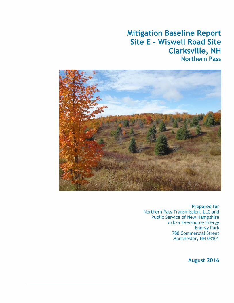
Mitigation Baseline Report Site E – Wiswell Road Site
Clarksville, NH Northern Pass
Prepared for Northern Pass Transmission, LLC and
Public Service of New Hampshire d/b/a Eversource Energy
Energy Park 780 Commercial Street Manchester, NH 03101
August 2016
Page 1 of 2
Conservation Easement Baseline Documentation Report (To satisfy Treasury Regulation 1.170A-14(g)(5))
Donor Information:
Name(s): Renewable Properties, Inc.
Address: 780 Commercial St, Manchester, NH 03101
Property Location:
Road: Wiswell Rd and Route 145
Town/County: Town of Clarksville, Coos County
Donee Name/Address: Eversource Energy Land Trust, Inc.
107 Selden Street Berlin, Connecticut 06037
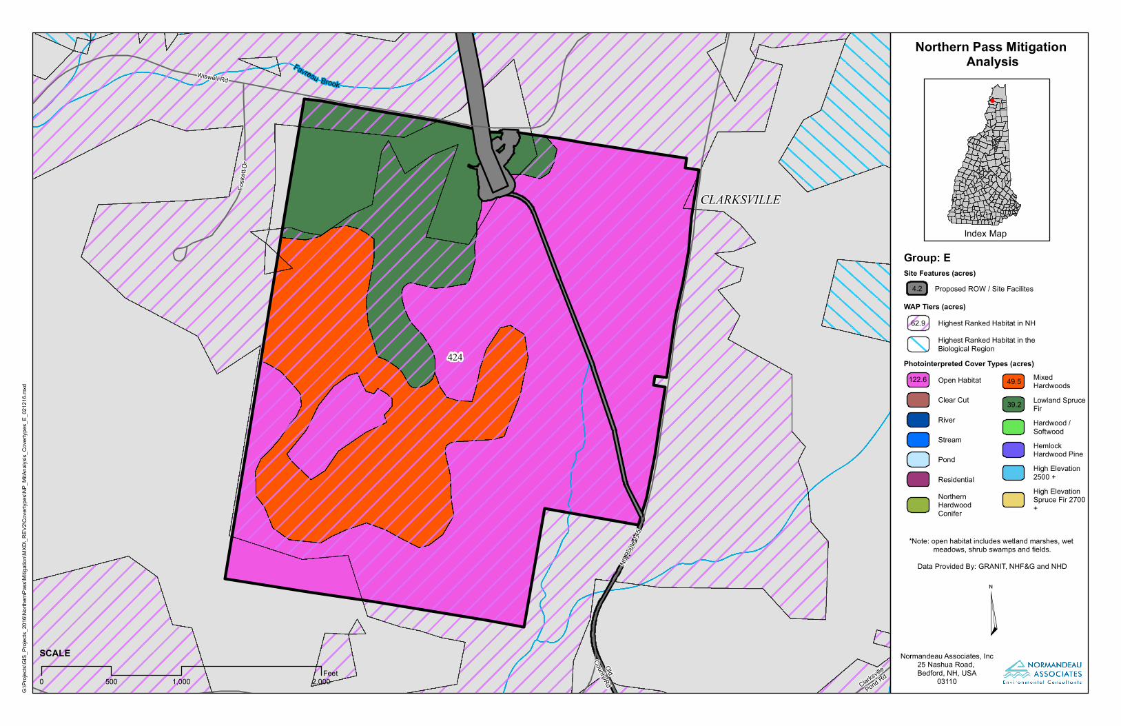
Land Types: Total acreage: 215.5 ac. 56.8 % Open Habitat 22 % Mixed Hardwood
18% Lowland Spruce Fir
Buildings, Structures, & Improvements on Property: Describe size, type, and condition of buildings, structures and improvements, including houses, sheds, towers, docks, barns, man-made ponds, roads, utilities, etc. Include historical, cultural and archeological features. Show locations on attached
map. Site E – the Wiswell Road Site in Clarksville NH is bordered by NH Route 145 along the eastern
property boundary of the site, while Wiswell Road is located along the northwestern property boundary.
A couple of gravel roadways also lead to wooded areas and open fields located on the southwest portion
of the site. A 2-3 acre transition station (#3) is planned for the northern edge of the parcel, and
underground electrical cable with a narrow maintained corridor will extend southeast to Route 145.
There are no structures on the property currently. A Phase I Site assessment was conducted and no
hazardous materials were observed.
Condition of Land: Describe condition and management status of forest or farmland, condition of wetlands or waterways, unusual features, listed species or natural communities; note erosion, gravel pits, dumping or pollution.
Site E is 215.5 acres. Site E’s cover types currently consist of old field, herbaceous meadow, and early
successional (regenerating) lowland spruce-fir and northern hardwood-coniferous forest. The site has
approximately 3,400 feet of frontage along the west side of NH Route 145 (the eastern property
boundary) and approximately 1,600 feet of frontage on the south side of Wiswell Road (the northwestern
property boundary). The ground surface at the site is hilly with a ridge that is oriented in a southwest to
northeast direction on the western portion of the site. The ridge generally slopes downhill to the
northwest and the southeast. The northeast portion of the site is also elevated and slopes downhill to the
southwest. Two swales flow south from the site, one that includes Pond Brook and a narrow swale of
wet meadow/shrub wetland present along an intermittent stream that flows southwest along the bottom
of the ridge. The site has approximately 63 acres of Highest Ranked Habitat in the State.
The surrounding landscape is a mixture of woodlands, open fields, agricultural fields, and residential
properties. Site E has excellent road frontage, lovely views, and much open upland terrain that could
easily be developed into multiple house lots.
Page 2 of 2
Natural Resource Inventory Summary (quantities are +/-):
Feature Measurement/Classification
Total Site Area 215.5 acres
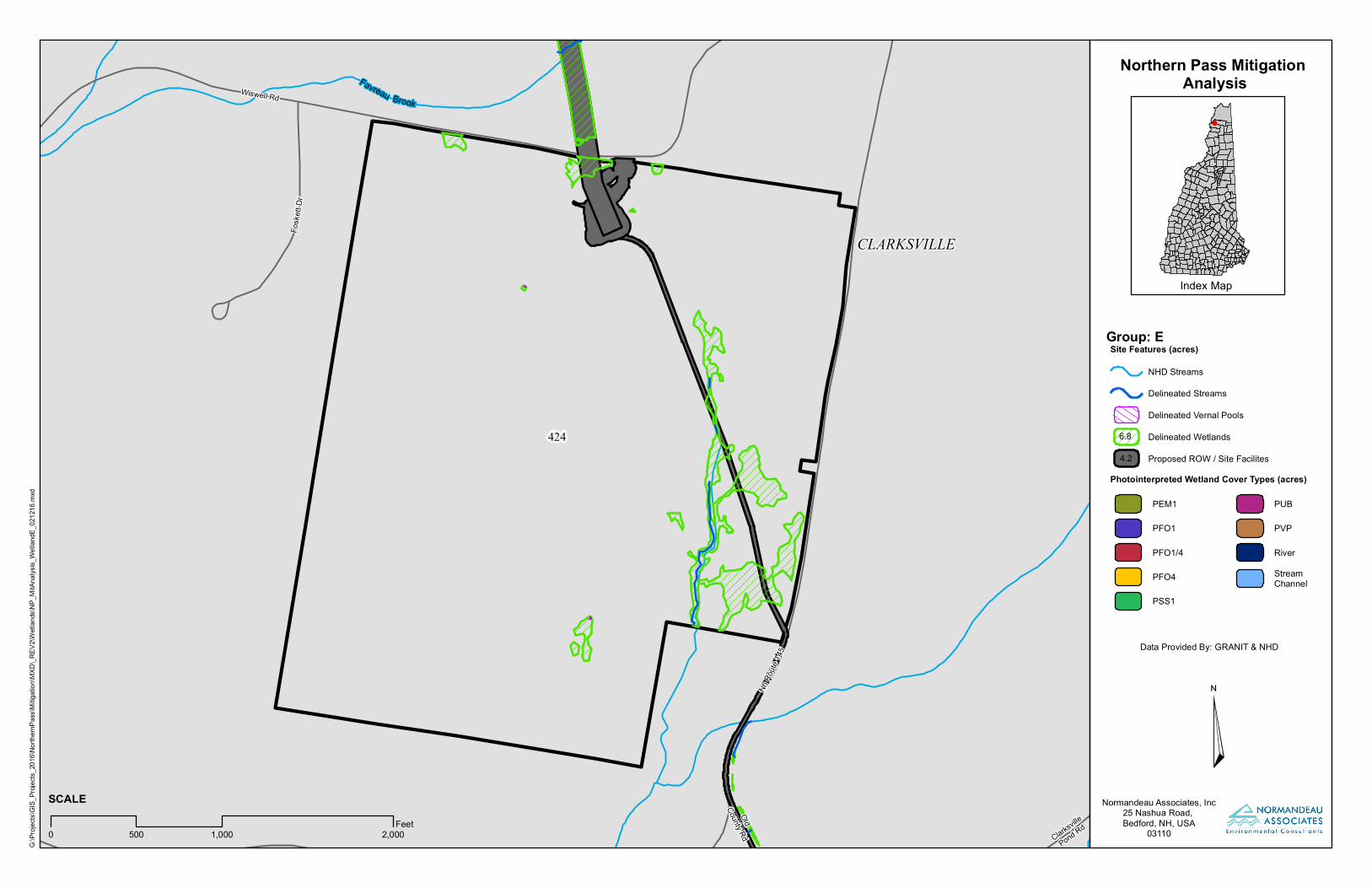
Waterbody Small intermittent stream, un-named
Shoreline Length N/A
Stream Length 1055.96 lf
Wetlands 7 acres (1 ac PSS; 6 ac PEM1) low estimate
In compliance with Treas. Reg. 1.170A-14(g)(5), this natural resources inventory is an accurate representation of the property at the time of the conservation donation.
for Eversource Energy Land Trust, Inc.
__________________________________________ Baseline Document Preparer Date Date
Attachments: (not all conservation parcels have all attachments)
USGS Location Map Ground Photos Aerial Property Map Natural Resource Maps (Soils, Cover Types, Wildlife Action Plan, etc.) Site Reconnaissance Notes Property Deeds and Survey Plans Conservation Easement Deed
USGS Location Map
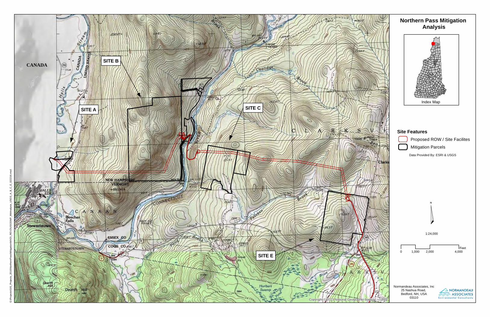
Copyright:© 2013 National Geographic Society, i-cubed
Northern Pass Mitigation Analysis
Data Provided By: ESRI & USGS
Index Map
Normandeau Associates, Inc25 Nashua Road, Bedford, NH, USA
03110
¤0 2,000 4,0001,000
Feet
CANADA
G:\Pr
ojects
\GIS_
Proje
cts_2
016\N
orthe
rnPas
s\Mitig
ation
\MXD
\_REV
2\USG
S\NP_
MitAn
alysis
_USG
S_A_
B_C_
E_02
2216
.mxd
Site FeaturesProposed ROW / Site FacilitesMitigation Parcels
1:24,000
SITE A
SITE B
SITE C
SITE E

Ground Photos
Site E – Wiswell Road Site
Ground Photographs
Photo 1. View of gravel roadway on the interior of
parcel LL 424.
Photo 2. View of the interior cover type on parcel
LL 424.
Photo 3. View of the interior cover type on parcel
LL 424.
Photo 4. View facing north from the northwest
corner of parcel LL 424.
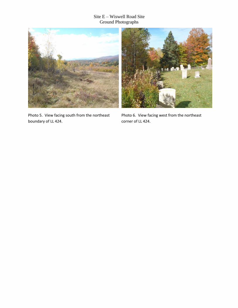
Site E – Wiswell Road Site
Ground Photographs
Photo 5. View facing south from the northeast
boundary of LL 424.
Photo 6. View facing west from the northeast
corner of LL 424.

Aerial Photo Property Map
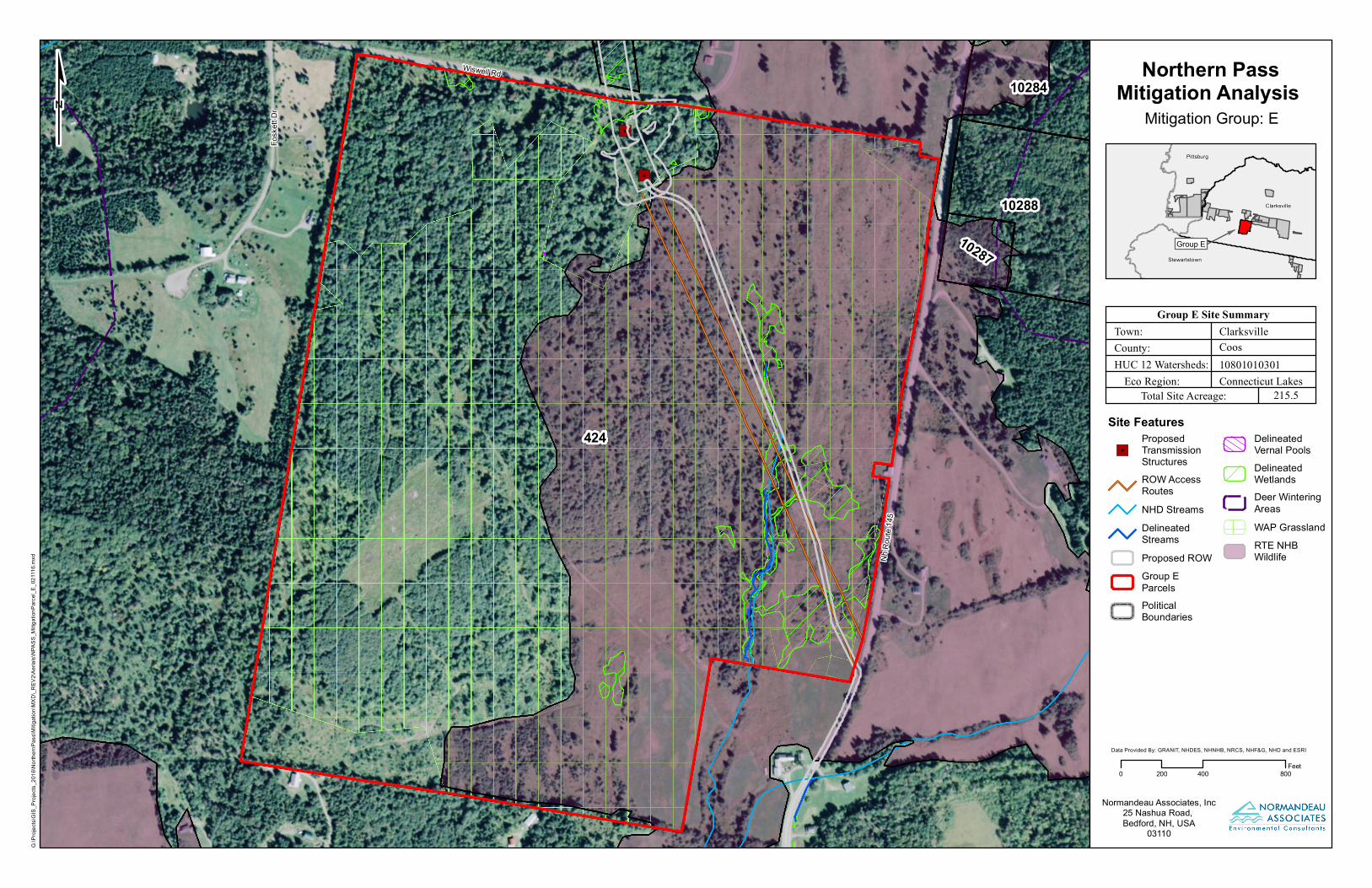
"6"6
"6
"6
"6
"6
"6
"6
"6
"6
424
10288
10284
10287
Nh R
oute
145
Wiswell Rd
Fosk
ett D
r
Northern PassMitigation Analysis
Mitigation Group: E
0 400 800200Feet
Site Features
"6ProposedTransmissionStructuresROW AccessRoutesNHD StreamsDelineatedStreamsProposed ROWGroup EParcelsPoliticalBoundaries
DelineatedVernal PoolsDelineatedWetlandsDeer WinteringAreasWAP GrasslandRTE NHBWildlife
¢
Group E Site SummaryTown:
Eco Region:
County:HUC 12 Watersheds:
Total Site Acreage:
ClarksvilleCoos10801010301Connecticut Lakes
215.5
Group EStewartstown
Clarksville
Pittsburg
G:\P
rojec
ts\GI
S_Pr
ojects
_201
6\Nort
hernP
ass\M
itigati
on\M
XD\_R
EV2\A
erials
\NPA
SS_M
itigati
onPa
rcel_E
_021
116.m
xd
Normandeau Associates, Inc25 Nashua Road, Bedford, NH, USA
03110
Data Provided By: GRANIT, NHDES, NHNHB, NRCS, NHF&G, NHD and ESRI
Natural Resource Maps
Clarksville
Pond Rd
Nh Ro
ute 14
5
OldCounty Rd
Wiswell Rd
Fosk
ett D
r
Favreau Brook
424
CLARKSVILLE
Northern Pass Mitigation Analysis
Group: E
Photointerpreted Cover Types (acres)Open Habitat
Clear Cut
River
Stream
Pond
ResidentialNorthernHardwoodConifer
MixedHardwoodsLowland SpruceFirHardwood /SoftwoodHemlockHardwood PineHigh Elevation2500 +High ElevationSpruce Fir 2700+
*Note: open habitat includes wetland marshes, wet meadows, shrub swamps and fields.
Data Provided By: GRANIT, NHF&G and NHD
Index Map
Normandeau Associates, Inc25 Nashua Road, Bedford, NH, USA
03110
¤0 1,000 2,000500
Feet
WAP Tiers (acres)Highest Ranked Habitat in NHHighest Ranked Habitat in theBiological Region
SCALE
G:\Pr
ojects
\GIS_
Proje
cts_2
016\N
orthe
rnPas
s\Mitig
ation
\MXD
\_REV
2\Cov
ertyp
es\N
P_Mi
tAnaly
sis_C
overt
ypes
_E_0
2121
6.mxd
Site Features (acres)Proposed ROW / Site Facilites
122.6
62.9
4.2
49.5
39.2
Favreau Brook
Clarksville
Pond Rd
Nh Ro
ute 14
5
OldCounty Rd
Wiswell Rd
Fosk
ett D
r
424
CLARKSVILLE
Northern Pass Mitigation Analysis
Group: E
Photointerpreted Wetland Cover Types (acres)
PEM1
PFO1
PFO1/4
PFO4
PSS1
PUB
PVP
RiverStreamChannel
Data Provided By: GRANIT & NHD
Index Map
Normandeau Associates, Inc25 Nashua Road, Bedford, NH, USA
03110
¤0 1,000 2,000500
Feet
SCALE
Site Features (acres)
NHD Streams
Delineated Streams
Delineated Vernal Pools
Delineated Wetlands
Proposed ROW / Site Facilites
G:\Pr
ojects
\GIS_
Proje
cts_2
016\N
orthe
rnPas
s\Mitig
ation
\MXD
\_REV
2\Wetl
ands
\NP_
MitAn
alysis
_Wetl
andE
_021
216.m
xd
4.2
6.8
Wiswell Rd
Foske
tt Dr
NH R
oute
145
418.04
424
10284
10287
10288
Lombard-Tunbridgecomplex,
8 to 15 percent slopes
Cabot siltloam, 8 to 15
percent slopes
Tunbridge-Plaisted-Lymancomplex, 15 to 25
percent slopes
Tunbridge-Plaisted-Lymancomplex, 8 to
15 percent slopes
Tunbridge-Lyman-Rockoutcrop complex, 25to 60 percent slopes
Howland gravellyloam, 3 to 8
percent slopes
Tunbridge-Lyman-Rockoutcrop complex,
25 to 60 percent slopes
Cabot silt loam, 3to 8 percent slopes
Tunbridge-Plaisted-Lymancomplex, 15 to 25
percent slopes
Tunbridge-Plaisted-Lymancomplex, 8 to 15percent slopes
Tunbridge-Plaisted-Lymancomplex, 25 to 35
percent slopes
Cabot silt loam, 8to 15 percent slopes,
very stony
Cabot silt loam, 8 to15 percent
slopes, very stony
Tunbridge-Plaisted-Lymancomplex, 25 to 35
percent slopes
Howland siltloam, 15 to 30 percent
slopes, very stony
Plaisted gravellyloam, 8 to
15 percent slopes
Howland silt loam,15 to 30 percent
slopes, very stony
Tunbridge-Lyman-Rockoutcrop complex, 15to 25 percent slopes
Cabot silt loam,8 to 15 percent
slopes, very stony
Lombard-Tunbridgecomplex, 15 to 25
percent slopesTunbridge-Plaisted-Lymancomplex, 8 to 15 percent
slopes
Tunbridge-Plaisted-Lymancomplex, 8 to 15percent slopes
Tunbridge-Lyman-Rockoutcrop complex, 15 to
25 percent slopes
Howland silt loam,8 to 15 percent
slopes, very stony
Wonsqueak muck,0 to 2 percent
slopes
Cabot silt loam,0 to 8 percent
slopes, very stony
Tunbridge-Lyman-Rockoutcrop complex, 15 to
25 percent slopes
Tunbridge-Plaisted-Lymancomplex,
15 to 25 percent slopes
Tunbridge-Plaisted-Lymancomplex, 15 to 25
percent slopes
Howland silt loam,8 to 15 percent
slopes, very stony
Tunbridge-Plaisted-Lymancomplex, 8
to 15 percent slopes
Tunbridge-Plaisted-Lymancomplex, 15 to 25
percent slopes
Wonsqueak muck, 0to 2 percent slopes
Tunbridge-Lyman-Rockoutcrop complex, 25 to
60 percent slopes
Tunbridge-Plaisted-Lymancomplex, 8 to 15percent slopes
Tunbridge-Plaisted-Lymancomplex, 3 to 8 percent
slopes
Tunbridge-Plaisted-Lymancomplex, 8 to 15 percent
slopes, very stony
Tunbridge-Plaisted-Lymancomplex, 8 to 15percent slopes
Tunbridge-Plaisted-Lymancomplex, 25 to 35
percent slopes
Cabot silt loam, 0to 8 percent slopes,
very stony
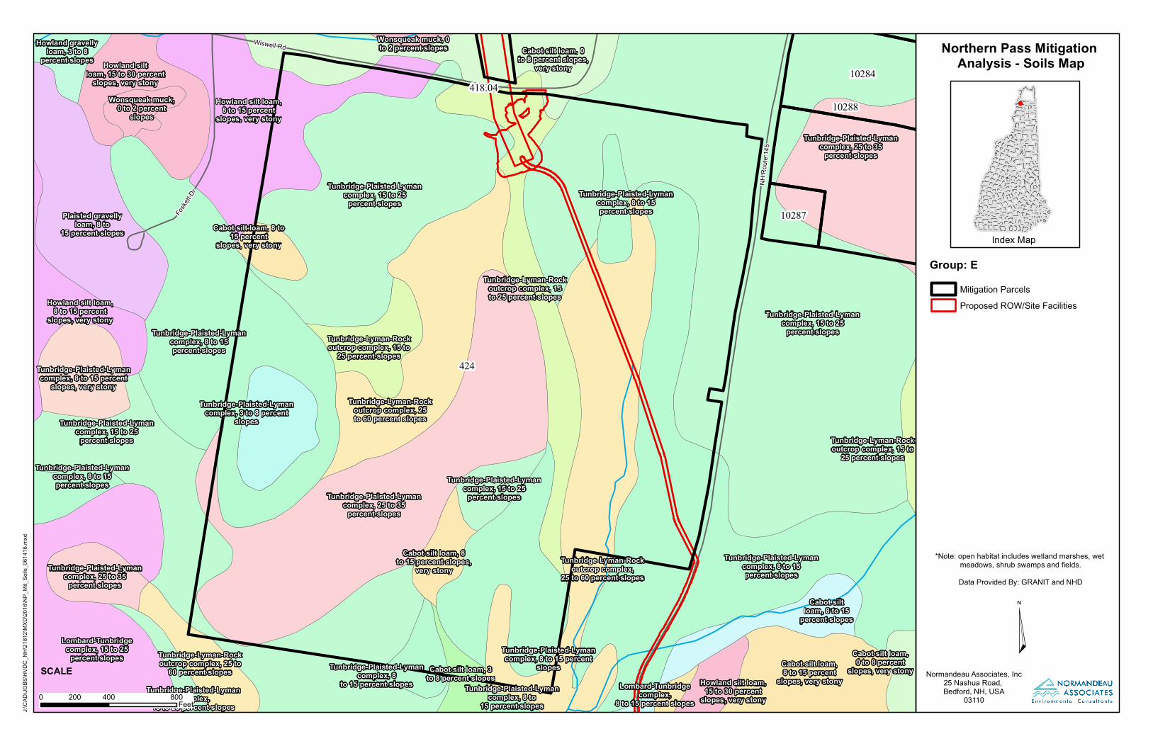
Northern Pass Mitigation Analysis - Soils Map
Group: E
*Note: open habitat includes wetland marshes, wet meadows, shrub swamps and fields.Data Provided By: GRANIT and NHD
Index Map
Normandeau Associates, Inc25 Nashua Road, Bedford, NH, USA
03110
¤0 400 800200
Feet
SCALE
J:\CA
D\JO
BS\H
VDC_
NH\21
812\M
XD\20
16\N
P_Mi
t_Soil
s_06
1416
.mxd
Mitigation ParcelsProposed ROW/Site Facilities
Wiswell Rd
Fosket
t Dr
NH R
oute
145
418.04
424
10283
10284
10287
10288
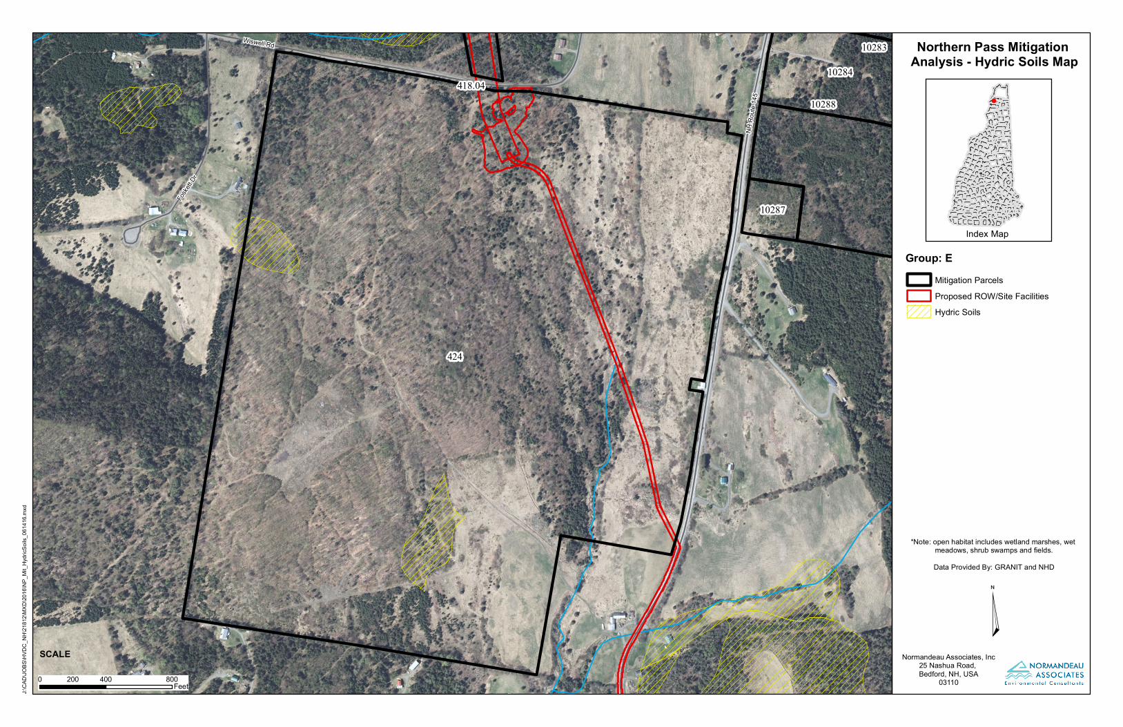
Northern Pass Mitigation Analysis - Hydric Soils Map
Group: E
*Note: open habitat includes wetland marshes, wet meadows, shrub swamps and fields.Data Provided By: GRANIT and NHD
Index Map
Normandeau Associates, Inc25 Nashua Road, Bedford, NH, USA
03110
¤0 400 800200
Feet
SCALE
J:\CA
D\JO
BS\H
VDC_
NH\21
812\M
XD\20
16\N
P_Mi
t_Hyd
ricSo
ils_06
1416
.mxd
Mitigation ParcelsProposed ROW/Site FacilitiesHydric Soils
Wiswell Rd
Fosket
t Dr
NH R
oute
145
418.04
424
10283
10284
10287
10288
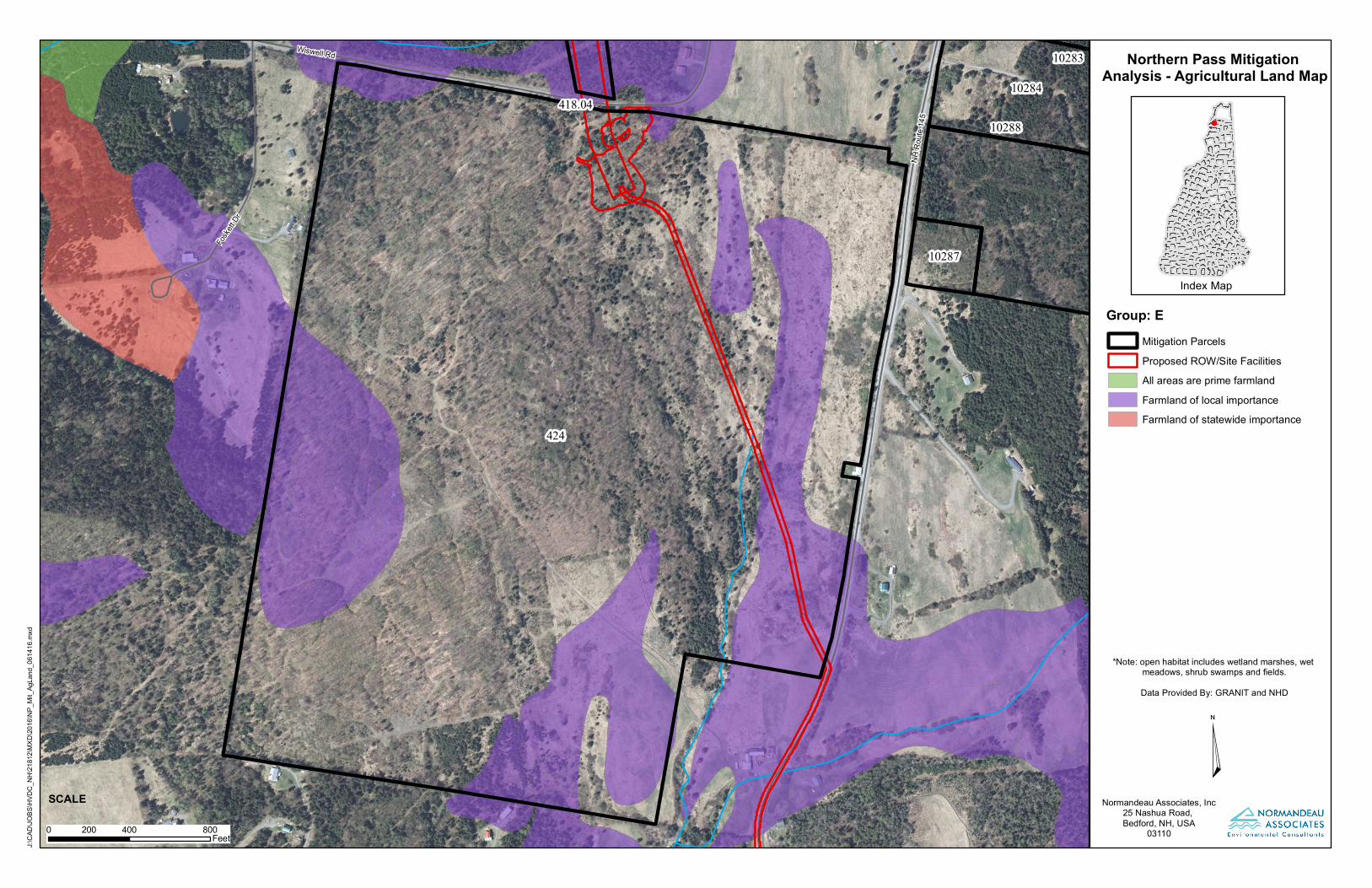
Northern Pass Mitigation Analysis - Agricultural Land Map
Group: E
*Note: open habitat includes wetland marshes, wet meadows, shrub swamps and fields.Data Provided By: GRANIT and NHD
Index Map
Normandeau Associates, Inc25 Nashua Road, Bedford, NH, USA
03110
¤0 400 800200
Feet
SCALE
J:\CA
D\JO
BS\H
VDC_
NH\21
812\M
XD\20
16\N
P_Mi
t_AgL
and_
0614
16.m
xd
Mitigation ParcelsProposed ROW/Site FacilitiesAll areas are prime farmlandFarmland of local importanceFarmland of statewide importance
Site Reconnaissance Notes
Wiswell Road and NH Route 145 Mitigation Parcel Field Reconnaissance
Notes
LL 424
A brief walkover of the parcel located southwest of the intersection of Wiswell Road and NH
Route 145 in the Town of Clarksville, New Hampshire was performed on June 28, 2016. The
purpose of the site visit was to obtain general information regarding the presence of access
roads, walking paths, streams, wetlands and other notable natural resources such as vernal
pools and rare species. The walkover was not intended as a comprehensive review of the
physical attributes of the site, but rather as a general review to identify features that may
provide additional mitigation potential in terms of unique natural resources, restoration
opportunity, and/or recreation potential (trail access).
An account of the major individual community types observed within the parcel was
performed during the walkover. The community types are identified according to The Natural
Communities of New Hampshire1. This classification does not provide descriptions for
communities that have been altered, such as harvested forest land or cleared agricultural areas.
In such cases these communities are described by their site conditions and vegetation present at
the time of the site visit (e.g. regenerating field/grassland community). The community types
discussed below represent those which were observed during the surveys and may not
represent a complete account of the communities present.
General Site Comments
Portions of this parcel were previously surveyed for the presence of rare plants, natural
communities, wetlands, streams, and vernal pools. A transition station, a facility where the
overhead transmission lines are converted to subterranean lines, is proposed to be located on
the north side of the site, with the underground lines running from the north-central portion of
the site to the southeast corner. Most of the west side of the parcel is forested and occupies
several hills that are generally drier than the old field communities on the east side of the parcel.
A stream originates in a wetland (potential spring) in the east and flows south until exiting the
parcel. The majority of the site is classified as grassland according to the New Hampshire
Wildlife Action Plan, although much of the western half is relatively mature second growth
forest. Old logging roads, some of which appear occasionally used by off-road vehicle (ORV)
traffic, cross throughout the site, providing access to the interior.
Northern Hardwood – Spruce – Fir Forest (S4)
1 Sperduto, D.D. and W.F. Nichols. 2011. The Natural Communities of New Hampshire.2
nd Ed. NH Natural Heritage
Bureau, Concord, NH. Pub. UNH Cooperative Extension, Durham, NH
This is the dominant forest type throughout the western portion of the site. It is located on
upland areas that show signs of past logging, but are still under a generally closed canopy of
yellow birch (Betula alleghaniensis), balsam fir (Abies balsamea), red spruce (Picea rubens), red
maple (Acer rubrum), and sugar maple (Acer saccharum). Inclusions of isolated pockets of Rich
Mesic Forest (S3) and Hardwood Seepage Forest (S3) are scattered throughout the extreme
western edge of the parcel, as indicated by the presence of blue cohosh (Caulophyllum
thalictroides), white baneberry (Actaea pachypoda), and tall meadow-rue (Thalictrum pubescens) in
the understory. One small patch of wild leek (Allium tricoccum var. tricoccum), a state watchlist
species, was found in one of these inclusions.
Regenerating Old Field – Logged Clearing (unranked)
This parcel has a greater amount of old field communities than any other parcel surveyed. The
eastern portion of this parcel and an upland clearing on the west side, have been maintained as
fields until recently. These fields are regenerating but still retain an open character that
supports an array of herbaceous and shrub species. The site visit in this community type
focused primarily on wildlife habitat. Rare plant surveys were performed throughout this
community during the 2014-2015 field effort.
Other Community Types
Herbaceous and scrub-shrub wetlands are present around the stream on the eastern portion of
the parcel, as seeps on the slopes above the stream, and in depressions that have formerly been
used as logging roads. Vegetation in these wetlands ranges from broad-leaved cattail (Typha
latifolia) in the seeps along the fields, various willow (Salix spp.) species, meadowsweet (Spiraea
alba var. latifolia), and steeplebush (Spiraea tomentosa) throughout the fields, and herbs common
in disturbed systems, such as nodding sedge (Carex gynandra), sallow sedge (Carex lurida),
woolly bulrush (Scirpus cyperinus), and sensitive fern (Onoclea sensibilis) in the logging roads.
Wildlife and Wildlife Habitat Value
Wildlife observations for LL424 were focused on the old field habitats located on the eastern
half of the parcel, and included a walk through the northern portion of the old field area on
June 28 and an informal roadside bird survey on June 30. Data from the NH Natural Heritage
Bureau include this portion of the parcel is part of a large complex of grasslands mapped as
providing habitat for the Northern Harrier, a New Hampshire State endangered species.
Grassland habitats suitable for Northern Harriers are also likely to be suitable for other
grassland dependent avian species.
The NHB harrier record is from 1998 and although harriers use a variety of open habitats,
including old fields, the habitat currently present on the parcel does not appear to be suitable
for harriers, due to the abundance and distribution of woody vegetation, including scattered
trees at least twenty feet high. Historic aerial photography of this parcel suggests that it was a
mix of forest cover and open pasture and that the eastern half of the parcel was grazed regularly
until about 2008-2011. The June 28 survey was conducted between 13:00- 14:00, late in the
breeding season, and 15 species of passerine were heard singing or calling. While ten of these
were species are typically associated with open or brushy habitats, only one, the savannah
sparrow, is classified as grassland dependent, and the overall abundance of and variety of birds
seemed low, given the extensive nature of the habitat present.
The roadside survey was conducted between 6:00 and 7:00, and consisted of three stops along
Rt 145, two adjacent to LL 424, and one to the south at Old Barn Road. The third stop was at
fields that are current mowed or grazed, to determine what type of grassland species might
currently be present in the area. All species detected during this roadside survey were
associated with open or brushy habitats. A total of seven species were detected on LL 424, while
five species were detected at the Old Barn Road stop, including savannah sparrow and an
American kestrel, a species also typically associated with open habitats. Also of note, bobolinks
may have been singing in the distance from a mowed parcel across Rt 145 to the east of LL 424.
The open habitat areas on LL 424 have great potential to be reclaimed and be subsequently
managed as habitat for grassland associated bird species, including northern harrier. To achieve
this goal, trees and brush should be cut and regular mowing and/or grazing should be
reintroduced to the parcel.
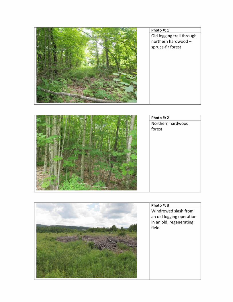
Photo #: 1
Old logging trail through northern hardwood – spruce-fir forest
Photo #: 2
Northern hardwood forest
Photo #: 3
Windrowed slash from an old logging operation in an old, regenerating field
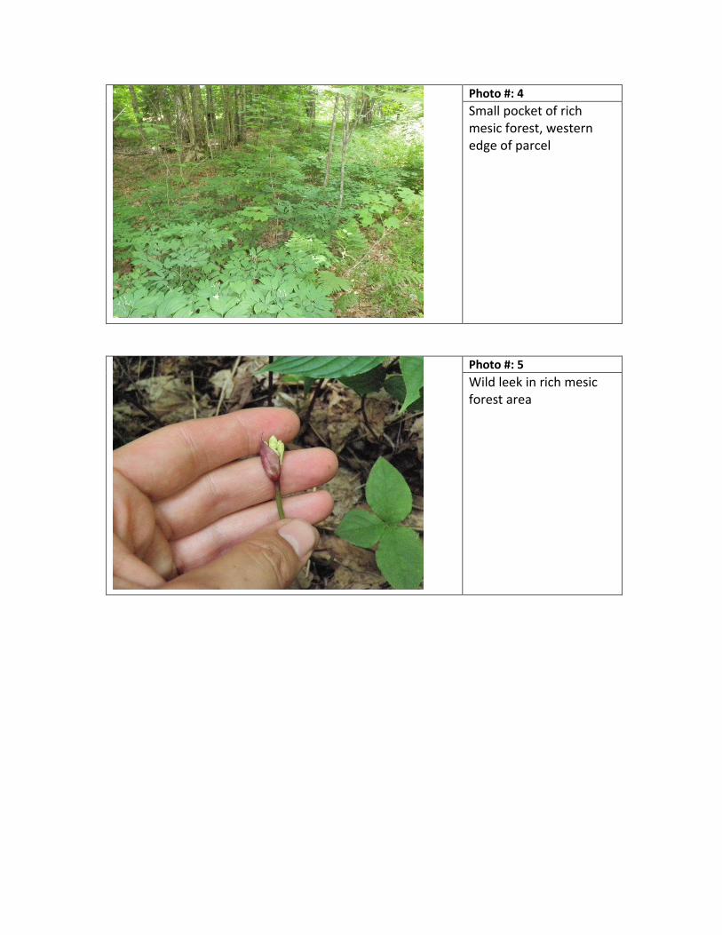
Photo #: 4
Small pocket of rich mesic forest, western edge of parcel
Photo #: 5
Wild leek in rich mesic forest area

Property Deeds and Survey Plans
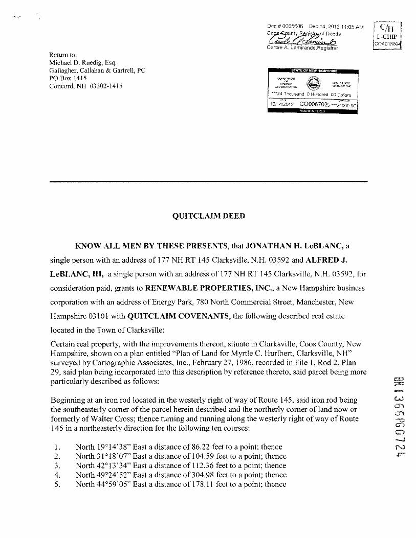
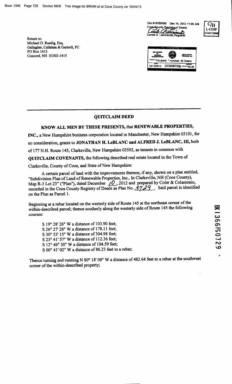
Book 1366 Page 729 Docket 5608 This image for BRIAN at at Coos County on 16/04/13
Return to:Michael D. Ruedig, Esq.Gallagher, Callahan &Gartrell, PCPO Box 1415Concord, NH 03302-1415
Doc#0005608 Dec14,201211:05AMC~r~dS
Carole A. Lamlrande,Regis1rar
..~.~~- Thouaanct • Hundred 40 Dollars12114f.2012 C0006703$ -~oo
QUITCLAIM DEED
KNOW ALL MEN BY THESE PRESENTS, that RENEWABLE PROPERTIES,
INC., a New Hampshire business corporation located in Manchester, New Hampshire 03101, for
no consideration, grants to JONATHAN H. LeBLANC and ALFRED J. LeBLANC, III, both
of 177 N.H. Route 145, Clarksville, New Hampshire 03592, as tenants in common with
QUITCLAIM COVENANTS, the following described real estate located in the Town of
Clarksville, County of Coos, and State of New Hampshire:
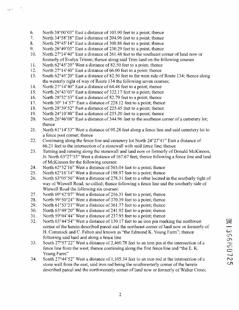
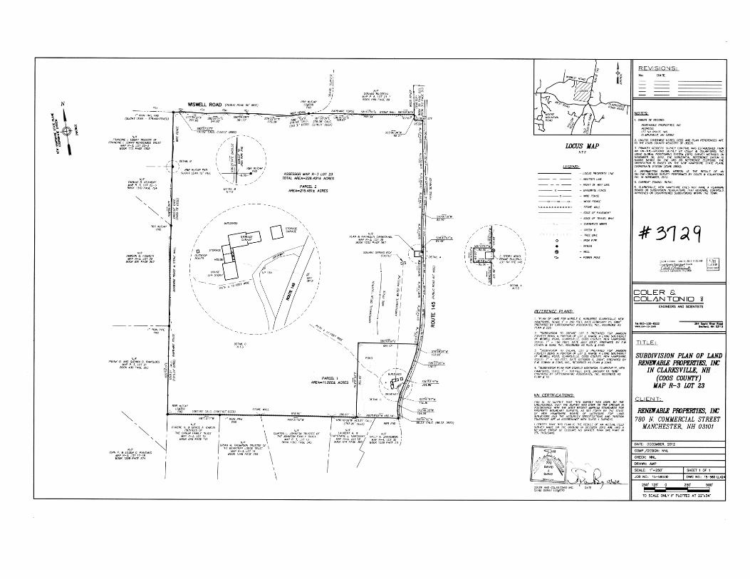
A certain parcel ofland with the improvements thereon, if any, shown on a plan entitled,"Subdivision Plan of Land of Renewable Properties, Inc., In Clarksville, NH (Coos County),Map R-3 Lot 23" ("Plan"), dated December jQ_, 2012 and prepared by Coler & Colantonio,recorded in the Coos County Registry of Deeds as Plan No. AU9 . Said parcel is identifiedon the Plan as Parcel 1.
Beginning at a rebar located on the westerly side of Route 145 at the northeast corner of thewithin-described parcel; thence southerly along the westerly side of Route 145 the followingcourses:
S 19° 28' 26" W a distance of 103.90 feet;S 26° 27' 28" W a distance of 178.11 feet;S 30° 53' 15" W a distance of 304.98 feet;S 23° 41' 57" W a distance of 112.36 feet;S 12° 46" 30" W a distance of 104.59 feet;S 00" 41' 02 IIW a distance of 86.23 feet to a rebar;
Thence turning and running N 80° 18' 08" W a distance of 482.64 feet to a rebar at the southwestcomer of the within-described property;
C/HL-CHIP
COA01
,
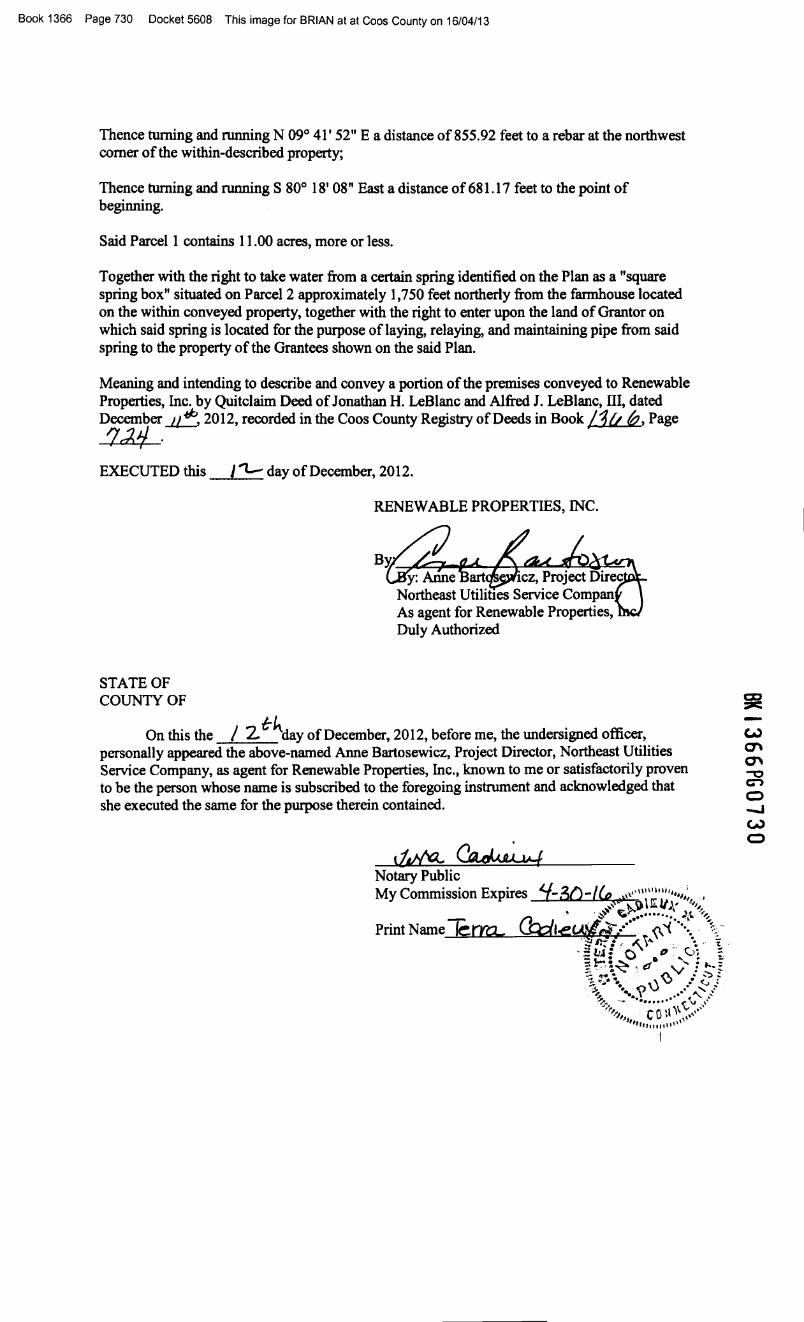
Book 1366 Page 730 Docket 5608 This image for BRIAN at at Coos County on 16/04/13
Thence turning and running N 09° 41' 52" E a distance of 855.92 feet to a rebar at the northwestcorner of the within-described property;
Thence turning and running S 80° 18' 08" East a distance of 681.17 feet to the point ofbeginning.
Said Parcel 1 contains 11.00 acres, more or less.
Together with the right to take water from a certain spring identified on the Plan as a "squarespring box" situated on Parcel 2 approximately 1,750 feet northerly from the farmhouse locatedon the within conveyed property, together with the right to enter upon the land of Grantor onwhich said spring is located for the purpose of laying, relaying, and maintaining pipe from saidspring to the property of the Grantees shown on the said Plan.
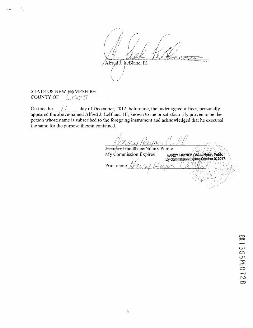
Meaning and intending to describe and convey a portion of the premises conveyed to RenewableProperties, Inc. by Quitclaim Deed of Jonathan H. LeBlanc and Alfred J. Lelslanc, III, datedDecember ~ 2012, recorded in the Coos County Registry of Deeds in Book IJu 6, Page7':)'1 . .EXECUTED this I"'l.- day of December, 2012.
RENEWABLE PROPERTIES, INC.
STATE OFCOUNTY OF
On this the I 2-C-~ay of December, 2012, before me, the undersigned officer,personally appeared the above-named Anne Bartosewicz, Project Director, Northeast UtilitiesService Company, as agent for Renewable Properties, Inc., known to me or satisfactorily provento be the person whose name is subscribed to the foregoing instrument and acknowledged thatshe executed the same for the purpose therein contained.
Conservation Easement Deed
PROPOSED DRAFT CONSERVATION EASEMENT DEED –
FOR DISCUSSION PURPOSES ONLY
THIS IS A NONCONTRACTUAL TRANSFER
PURSUANT TO NEW HAMPSHIRE RSA 78-B
AND IS THEREFORE EXEMPT FROM THE NEW
HAMPSHIRE REAL ESTATE TRANSFER TAX.
CONSERVATION EASEMENT DEED
With Grant of Access
RENEWABLE PROPERTIES, INC., a New Hampshire corporation with a principal place of business
at 780 North Commercial Street, Manchester, New Hampshire 03101, (hereinafter referred to as the
"Grantor," which shall, unless the context clearly indicates otherwise, include the Grantor's successors and
assigns),
for consideration paid, with WARRANTY covenants, grants in perpetuity to:
EVERSOURCE ENERGY LAND TRUST, INC., a Connecticut nonprofit corporation, with a principal
place of business at 107 Selden Street, Berlin, Connecticut 06037, having been determined by the Internal
Revenue Service to be an income tax exempt corporation, contributions to which are deductible for federal
income tax purposes pursuant to the United States Internal Revenue Code (hereinafter referred to as the
"Grantee" which shall, unless the context clearly indicates otherwise, include the Grantee's successors and
assigns),
with Third Party Right of Enforcement therein granted to the STATE OF NEW HAMPSHIRE acting
through its DEPARTMENT OF ENVIRONMENTAL SERVICES, an administrative agency duly
organized and existing under the laws of the State of New Hampshire, with a principal place of business at
29 Hazen Drive, City of Concord, County of Merrimack, State of New Hampshire, 03302, (the “Third
Party Holder”),
the Conservation Easement (herein referred to as the "Easement") hereinafter described with respect to that
certain parcel or parcels of land (herein referred to as the "Property") with any and all buildings, structures,
and improvements thereon/being unimproved land situated on Route 145 and Wiswell Road, in the Town
of Clarkesville, County Coos, State of New Hampshire, with said Property and Easement more particularly
bounded and described in Appendix "A" attached hereto and made a part hereof, and on a plan set dated
prepared by, ______________ titled “ ”, and recorded at the ______________________
County Registry of Deeds as Plan # __________________ (hereinafter referred to as the “Plan”).
The Easement has been granted as a part of a compensatory wetlands mitigation package for NHDES File
#__________.
1. CONSERVATION PURPOSES
The Easement hereby granted is pursuant to NH RSA 477:45-47, exclusively for the following
conservation purposes (herein referred to as the “Purposes”) for the public benefit:
Page 2 of 24
A. To promote the conservation of forests, wetlands, natural watercourses, and wildlife thereon as
documented in the baseline documentation report dated April 2016 entitled “Northern Pass Transmission
Project Natural Resource Compensatory Mitigation Plan – Preservation Area E – Clarkesville, NH –
Mitigation Baseline Report” (the “Report”), which Report is on file at the office of the Department of
Environmental Services and is incorporated herein in full;
B. To preserve and protect in perpetuity the natural vegetation, soils, hydrology, natural habitat and the
scenic and aesthetic character of the Property so that the Property retains its natural qualities and functions;
C. To promote the North Country Council’s goals of forest block protection and wetlands and wetland
buffer protection;
D. To prevent any future development, construction, or use that will significantly impair or interfere with
the conservation values of the Property, while allowing the reserved rights of Grantor as allowed under
Section 3 hereof;
E. To maintain or enhance the water quality and aquatic and wildlife habitat of the Pond Brook and other
ground and surface water resources including wetlands, wet meadow/shrub wetland, streams, riparian areas
and aquifers on the Property;
F. To protect and enhance the value of abutting and neighboring natural resources, open spaces, and
conservation areas;
G. To permit recreational, scientific, and educational activities on the Property including, but not limited
to, hiking, hunting, fishing, camping, cross country skiing, snowshoeing, horseback riding, snowmobiling,
motorized bikes and small all-terrain vehicles (“ATVs”) consistent with the terms and conditions herein;
H. To promote the conservation of open spaces, particularly the conservation of the productive forest land
of which the Property consists and of the wildlife habitat thereon including threatened and endangered
species, such as the northern harrier / kestrel, and the long-term protection of the Property’s capacity to
produce economically valuable forestry products, including timber, pulpwood, and other forest products;
and
I. To encourage the continued use of rural farmland for agriculture in the portions of the Property
deemed to be suitable in the Report.
The above Purposes are consistent with New Hampshire RSA Chapter 79-A which states: "It is hereby
declared to be in the public interest to encourage the preservation of open space, thus providing a healthful
and attractive outdoor environment for work and recreation of the state's citizens, maintaining the character
of the state's landscape, and conserving the land, water, forest, agricultural and wildlife resources.”
All of these Purposes are consistent and in accordance with the U.S. Internal Revenue Code of 1986, as
amended (the “Code”), Section 170(h). The Grantee is an organization described in Section 501(c)(3) and
Section 509(a)(1) of the Code, and meets the requirements of Section 509(a)(1) of the Code. Grantee is a
"qualified organization," as such term is defined in Section 170(h)(3) of the Code.
Page 3 of 24
2. USE LIMITATIONS
Subject to the reserved rights specified in Section 3 hereof, the Grantor covenants for itself and its
legal representatives, successors and assigns that the Property will at all times be held, used, and conveyed
subject to, and not used in violation of, the following covenants that shall run with the Property in
perpetuity:
A. The Property shall be maintained in perpetuity in an undeveloped and natural condition consistent with
the Purposes of this easement, without there being conducted thereon any industrial or commercial
activities, except Forestry or Agriculture performed by the Grantee, as described below, and provided that
such uses shall not degrade the conservation purposes of this Easement.
i. Definitions:
a. Forestry: For the purposes hereof, “Forestry” shall include the growing, stocking, cutting,
and sale of forest trees of any size capable of producing timber or other forest products, all
as not detrimental to the Purposes of this Easement. Forestry shall also include all forestry
and forest management activities performed for commercial or industrial purposes,
including barter transactions, and non-commercial timber stand improvement activities,
wildlife habitat improvement, or thinning the forest stand to maintain a view.
b. Agriculture: For the purposes hereof, “Agriculture” shall include animal husbandry,
floriculture, and horticulture activities, the production of plant and animal products for
domestic or commercial purposes, haying or the growing of food crops, all as not
detrimental to the Purposes of this Easement. Agriculture shall also include all
agricultural activities performed for commercial or industrial purposes, including barter
transactions and sale of products produced on the Property.
ii. Requirements for Forestry:
a. Forestry shall be carried out in accordance with all applicable local, state, and federal laws
and regulations, and, to the extent reasonably practicable, in accordance with then-current,
generally accepted best management practices for the sites, soils, and terrain of the
Property and shall not be detrimental to the Purposes of the Easement. For references on
best management practices see:
“Best Management Practices for Erosion Control on Timber Harvesting Operations in
New Hampshire” (J.B. Cullen, 2004); and
“Good Forestry in the Granite State: Recommended Voluntary Forest Management
Practices for New Hampshire” (New Hampshire Forest Sustainability Standards Work
Team, 2010), or similar successor publications.
b. The following Forestry riparian buffer zones shall apply for Forestry activities and other
tree cutting and removal operations within and adjacent to wetlands, perennial streams and
rivers, hereinafter referred to collectively as “water body or water bodies.” Streams and
rivers shall be identified as those shown on 7.5 minute United States Geologic Survey
Quadrangle maps. Wetlands shall include any wetlands shown on National Wetland
Page 4 of 24
Inventory maps, Town wetland inventory maps, NH GRANIT land cover maps, or other
sources mutually agreed to by the Grantor and Grantee. The maps included in the Report
designate the approximate locations of the water bodies and riparian buffer zones.
i. Forestry riparian buffers zones shall include one hundred (100) feet from each
side of a water body and shall be expanded as necessary to encompass all
vegetative communities with slopes greater than 35%, or soils classified as highly
erodible that are adjacent to the water body.
ii. The distance of the riparian buffer shall be measured from the edge of the normal
high water mark of the water body. In areas where there are wetlands contiguous
to a stream or river the riparian buffer shall be measured from the upland edge of
the wetland.
iii. There shall be no Forestry activities, soil disturbance, tree cutting and removal, or
application of herbicides or pesticides within the water body and the first twenty-
five (25) feet from the normal high water mark or water body edge as defined
above. The Grantee may request permission from the Grantor to conduct any of
the before stated activities for wildlife habitat improvement purposes, construction
of wildlife viewing platforms and maintaining the view from said platforms, or to
meet other specific natural resource or ecological goals (e.g., invasive species
removal). For wildlife habitat improvements or improvements for natural
resource or ecological goals, the Grantee must submit the request to the Grantor as
part of the Management Plan or an amendment thereto. For the construction of
wildlife viewing platforms, the Grantee shall submit the request to the Grantor as
a written plan with scaled drawings indicating the location, size, materials,
vegetation to be impacted by the platform and viewing zone, and access to the
viewing platform. The Grantor shall first consult with the Third Party Holder and
either approve, deny, or approve with conditions the request at their sole
discretion.
iv. Within the remainder of the riparian buffer zone tree harvest methods shall be
limited to single tree or small group selection cuts, leaving a well-distributed,
uneven-aged stand of trees.
v. No new roads or log landings shall be constructed within riparian buffer zones,
except in circumstances where complying with this provision may result in a
greater overall negative environmental impact or would preclude reasonable
access to areas suitable to Forestry. Existing roads, as identified by the Baseline
Documentation Report, may be retained and maintained. Skid trails and log
landings shall be kept to the minimum reasonably necessary for tree removal.
Any roads, skid trails, and log landings within a riparian buffer zone shall be
designed and maintained to minimize degradation of water quality and aquatic
habitat.
c. Forestry shall be performed using silvicultural practices that enhance or maintain the value
of timber while recognizing that the ecological, aesthetic, wildlife, or other non-timber
values are important components of the forest. To the extent reasonably practicable,
Forestry shall meet the following goals.
maintenance of soil productivity;
protection of water quality, wetlands, and riparian zones;
maintenance or improvement of the overall quality of forest products;
Page 5 of 24
conservation of scenic quality and recreational access and trails;
protection of significant or fragile natural areas, exemplary natural communities,
and rare, threatened and endangered species, including their habitats;
protection of significant historic and cultural features; and
conservation of native plant and animal species.
d. Any Forestry shall be performed in accordance with a written Forest Management Plan
consistent with this Easement, prepared by a licensed professional forester, or by other
qualified person approved in advance and in writing by the Grantor, at the sole expense of
Grantee (the “Management Plan”). The Management Plan shall be subject to the approval
of the Grantor and the Third Party Holder, and the NH Fish & Game Department shall be
permitted to provide the Third Party Holder with advisory comments and suggestions.
The Management Plan shall not permit the Grantee to interfere with the Grantor’s reserved
rights set forth in Section 3.G., Section 3.H. and Section 3.J. hereof.
e. Said Management Plan shall have been prepared not more than ten (10) years prior to the
date any harvesting is expected to commence. Or, if more than ten (10) years old, the plan
shall have been reviewed and updated as required by such a licensed forester or other
qualified person at least thirty (30) days prior to the date of harvest.
f. Said Management Plan shall include a statement of the objectives, and shall specifically
address:
the accomplishment of those Purposes for which this Easement is granted, and
water bodies as defined herein, riparian buffer zones and their delineation on a map(s)
in the plan and how water bodies and vernal pools will be protected in association
with forest management activities including but not limited to road construction and
maintenance and implementation of stand prescriptions.
g. At least thirty (30) days prior to any Forestry activities, the Grantor shall have received
from the Grantee a written certification, signed by a licensed professional forester, or by
other qualified person approved in advance and in writing by the Grantee, that the
Management Plan, as described in 2.A.ii, a-d, above, has been prepared in compliance
with the terms of this Easement. The Grantor may request the Grantee to submit the
Management Plan itself to the Grantor within ten (10) days of such request, but
acknowledges that the Management Plan’s purpose is to guide forest management
activities in compliance with this Easement, and that the actual activities will determine
compliance therewith.
h. Forestry activities shall be conducted in accordance with said Management Plan and be
supervised by a licensed professional forester, or by other qualified person approved in
advance and in writing by the Grantor.
i. Prior to conducting Forestry activities, in those areas proposed for the forest activities the
riparian buffers shall be clearly marked by a licensed professional forester, or other
qualified person approved in advance and in writing by the Grantor.
j. In areas used by, or visible to the general public, such Forestry shall be carried out, to the
extent reasonably practicable, in accordance with the recommendations contained in “A
Guide to Logging Aesthetics: Practical Tips for Loggers, Foresters, and Landowners”
(Jones 1993), or similar successor publications.
k. Notwithstanding any other provision of this Easement, with respect to that portion of the
Property located east of the Transmission Line ROW (as hereinafter defined), maintaining
the currently existing open habitat shall be permitted and encouraged.
Page 6 of 24
l. All costs related to the performance of any and all Forestry activities by the Grantee
pursuant to the Management Plan shall be paid solely by the Grantee, and all profits from
the Grantee’s Forestry activities shall be deposited into the Grantee’s stewardship fund
and dedicated towards the perpetual stewardship of the Property.
iii. Requirements for Agriculture: Agriculture for industrial or commercial purposes shall be
performed, to the extent reasonably practicable, in accordance with a coordinated
management plan for the sties and soils of the Property. The management plan shall be
subject to the approval of the Grantor and the Third Party Holder. The management plan
shall not permit the Grantee to interfere with the Grantor’s reserved rights set forth in
Section 3.G., Section 3.H. and Section 3.J. hereof. Said Agriculture shall not be
detrimental to the Purposes of this Easement, nor materially impair the scenic quality of
the Property as viewed from public roads, or public trails. Said Agricultural management
activities shall be in accordance with the then-current scientifically based practices
recommended by the University of New Hampshire’s Cooperative Extension Service, by
the U.S. Department of Agriculture’s Natural Resources Conservation Service, by the
New Hampshire Department of Agriculture, Markets, and Food, including but not limited
to recommended practices in said NH Department’s “Manual of Best Management
Practices (BMP’s) for Agriculture in New Hampshire” as may be revised, updated, or
superseded from time to time, or by other successor governmental natural resource
conservation and management agencies then active. Agriculture shall only be performed
in those locations noted on the Report as suitable for Agriculture, which are primarily
located in the southeastern quadrant of the Property. All costs related to the performance
of any and all Agricultural activities by the Grantee pursuant to the management plan shall
be paid solely by the Grantee, and all profits from the Grantee’s Agricultural activities
shall be deposited into the Grantee’s stewardship fund and dedicated towards the
perpetual stewardship of the Property.
B. The Property shall not be subdivided and, if the property is comprised of more than one individual
parcel, none of the individual parcels that together comprise the Property shall be conveyed separately
from one another, except that the lease of any portion of the Property for any use permitted by this
Easement shall not violate this provision.
C. No structure or improvement shall be constructed, placed, or introduced onto the Property, except for
structures and improvements which are: i) necessary in the accomplishment of the Forestry, Agriculture,
Reserved Transmission Line Rights (as hereinafter defined in Section 3.H.), conservation, habitat
management, or noncommercial outdoor recreational uses of the Property and which may include but not
be limited to a road, dam, fence, local utility distribution line, bridge, culvert, barn, shed, wildlife viewing
platform, maple sugar house, welcome center, nature center, portable bathrooms or a small unpaved
parking lot as shown on the Plan or in the Report to facilitate public access to the Property; and ii) not
detrimental to the Purposes of this Easement. Notwithstanding the above, there shall not be constructed,
placed, or introduced onto the Property any of the following structures or improvements: dwelling, mobile
home, cabin, residential driveway, any portion of a septic system, tennis court, swimming pool, athletic
field, golf course, or aircraft landing area.
D. No removal, filling, or other disturbances of soil surface, nor any changes in topography, surface or
Page 7 of 24
subsurface water systems, wetlands, or natural habitat shall be allowed unless such activities:
i. are commonly necessary in the accomplishment of the Forestry, Agriculture, Reserved
Transmission Line Rights, conservation, habitat management, or noncommercial outdoor
recreational uses of the Property; and
ii. do not harm state or federally recognized rare, threatened, or endangered species, or exemplary
natural communities, such determination of harm to be based upon information from the New
Hampshire Natural Heritage Bureau or the agency then recognized by the State of New Hampshire
as having responsibility for identification and/or conservation of such species and/or natural
communities; and
iii. are not detrimental to the Purposes of this Easement.
Prior to commencement of any such activities, all necessary federal, state, local, and other governmental
permits and approvals shall be secured.
E. No outdoor signs shall be displayed on the Property except as desirable or necessary in the
accomplishment of the Forestry, Agriculture, Reserved Transmission Line Rights, conservation or
pedestrian outdoor recreational uses of the Property, and provided such signs are not detrimental to the
purposes of this Easement. No sign on the Property shall exceed sixteen (16) square feet in size, and no
sign shall be artificially illuminated.
F. There shall be no mining, quarrying, excavation, or removal of rocks, minerals, gravel, sand, topsoil,
or other similar materials on the Property, except in connection with any improvements made pursuant to
the provisions of sections 2.A., C., D., or E., above. No such rocks, minerals, gravel, sand, topsoil, or
other similar materials shall be removed from the Property.
G. There shall be no dumping, injection, burning, or burial of refuse, trash, rubbish, debris, junk, waste,
man-made materials or materials then known to be environmentally hazardous, including vehicle bodies or
parts, or other similar substances.
H. The Grantor shall not operate or grant permission to operate motorized vehicles on the Property,
except as allowed in Section 3.A., Section 3.G. and Section 3.H. below.
I. The Property shall not be posted against, and the Grantor shall keep access to and use of the Property
open to the public for, pedestrian and bicycle, non-motorized, non-commercial, outdoor recreational and
outdoor educational purposes as will have minimal impact on the Property, such as but not limited to
hiking, mountain biking, wildlife observation and cross-country skiing, but the landowner shall retain the
right whether to allow hunting, fishing and camping. However, the Grantee shall be under no duty to
supervise said access, use, or purpose. The Grantee reserves the right to post the Property against public
access to forestland during harvesting or other Forestry or Agricultural activities.
Nothing contained in this Easement shall be construed to entitle the Grantee to bring any actions
against the Grantor for any injury to or change in the Property resulting from causes beyond the Grantor’s
control, including but not limited to fire, flood, storm and earth movement, or from any prudent action
Page 8 of 24
taken by the Grantor under emergency conditions to prevent, abate, or mitigate significant injury to the
Property resulting from such causes. The parties to this Easement agree that in the event of damage to the
Property from acts beyond the Grantor’s control, that if it is desirable that the Property be restored, the
parties will cooperate in attempting to restore the Property if practicable.
3. RESERVED RIGHTS
The Grantor hereby reserves to and for Grantor and its legal representatives, successors and
assigns: (i) all customary rights and privileges of property ownership associated with the Property that are
not specifically restricted by the terms of Section 2 of this Easement or that do not materially interfere with
the Purposes of this Easement, and (ii) notwithstanding the terms of Section 2 hereof, the following rights
and privileges set forth under the subparagraphs of this Section 3 shall be specifically permitted on the
Property as rights and privileges of Grantor, its employees, agents, contractors, licensees, permittees,
invitees, successors, assigns and other third parties, and in the event of a conflict between the Use
Limitations set forth in Section 2 hereof and the Reserved Rights set forth in this Section 3, the provisions
of this Section 3 shall control. Except as specifically set forth in this Easement as the responsibility of the
Grantee, the costs of exercising any and all of the Reserved Rights set forth in this Section 3 shall be solely
the responsibility of the Grantor.
A. The right to operate motorized vehicles, and permit others to operate said vehicles, for the
purposes of maintaining and managing the Property, the Transmission Line ROW (as hereinafter defined),
the Transmission Lines (as hereinafter defined), the Transition Station (as hereinafter defined) or as
expressly permitted pursuant to this Section 3, including but not limited to emergency rescue operations,
Forestry, Agriculture, habitat management, the Reserved Transmission Line Rights and to control or
remove non-native or invasive species. This provision is an exception to Section 2.H., above.
B. The right to construct, relocate, maintain, or use trails, fences, bridges, gates, stone walls, woods
roads, gravel roads, and rights-of-way on the Property, as reasonably necessary for the exercise of
Grantor’s rights and privileges on the Property (including but not limited to rights associated with passive
recreational activities), or necessary and desirable in controlling unauthorized use or facilitating authorized
use of the Property. This provision includes the right to construct and maintain, or allow to be constructed
and maintained, on the Property a small unpaved parking lot as shown on the Plan or in the Report to
facilitate public access to the Property.
C. The right to construct, relocate, erect, and maintain signs setting forth and describing permitted
and prohibited uses of the Property (including the prohibition of hunting if Grantor so chooses to prohibit
hunting on the Property by the general public), identifying trails, locations, property boundaries, natural
features, or similar items, or identifying the owner of the Property and the holder of this Easement.
D. The right to restrict or permit hunting, fishing and camping on the Property.
E. The right to conduct, or allow to be conducted, "passive noncommercial outdoor recreational
activities" on the Property. Passive outdoor recreational activities shall include but not be limited to hiking,
running, snowshoeing, hunting, fishing, camping, target shooting, trapping, bicycling, skiing, nature
studies, horseback-riding, and other similar forms of recreation and activities that expand human
knowledge and appreciation of wildlife, forest management, and the natural world.
Page 9 of 24
F. The right to require the Grantee to enter into the Required Assignment, as hereinafter defined in
Section 6.E. Notwithstanding any other provision of this Easement, if the Grantee is found to be in breach of
Section 6.E by a court of competent jurisdiction and venue, the Grantee shall be required to reimburse the
Grantor for all reasonable costs incurred by the Grantor in enforcing the terms of Section 6.E, including, but
not limited to, reasonable attorneys’ fees and costs and expenses of suit.
G. The right to operate on the Property, and to allow others and the general public to operate on the
Property, small motorized vehicles (including small boats, snowmobiles, ATVs, “4-wheelers”, OHRVs,
motorized bikes and other similar off-highway recreational motorized vehicles) for the purposes of maintaining
and managing the Property and for other recreational purposes including, but not limited to, snowmobiling,
hunting, fishing, and traveling the trails on the Property. Grantor reserves the right, and to allow others the
right, to develop, construct, relocate, maintain, groom, or use the trails, fences, bridges, gates, stone walls,
woods roads and rights-of-way on the Property in furtherance of the recreational purposes set forth herein.
Grantor further reserves the right to seasonally designate certain trails for snowmobile use only. Such use of
the Property shall be exclusively located on the trails depicted on the Plan or in the Report, or as agreed to by
Grantor and Third Party Holder. This provision is an exception to Section 2.H. and 2.I.
H. Grantor’s Reserved Transmission Line Rights.
i. Notwithstanding the restrictions set forth in Section 2 hereof, the Grantor hereby excepts and reserves
to itself, its successors and assigns forever, the following exclusive and perpetual rights and easements
(the “Reserved Transmission Line Rights”) over, under, in and on a 120-foot wide right of way, or
such lesser amount as shown on the Plan, relative to the Transmission Lines and no more than two and
a half acres in size relative to the Transition Station (collectively, the “Transmission Line ROW”), as
shown on the Plan or as relocated pursuant to a survey, as required by any governmental permit
approval, or at the sole discretion of Grantor if unforeseen natural conditions or events require the
relocation of the Transmission Lines, to be exercised in compliance with all applicable federal, state
and local laws, rules, regulations and permits:
a. The right to erect, install, construct, repair, maintain, rebuild, upgrade, uprate, replace,
expand, relocate, inspect, operate and remove aboveground and/or underground
transmission lines for electricity, including, without limitation, one or more poles, towers,
wires, cables, conductors, ducts, transition stations, manholes and other equipment,
structures, fixtures and appurtenances useful in conducting electricity and/or for
providing and maintaining electric service (the “Transmission Lines”) and a transition
station with perimeter fencing, driveway and detention pond (the “Transition Station”) in
the Transmission Line ROW currently existing or to be created as set forth herein. In the
event a Transmission Line ROW does not currently exist on the Property, prior to any use
of the Property for the Transmission Lines, the parties shall create a Transmission Line
ROW, no more than one hundred twenty (120) feet in width relative to the Transmission
Lines, and no more than four (4) acres in size relative to the Transition Station, and in a
location to be determined at the sole discretion of Grantor and consistent with all
applicable federal and state permits and approvals governing the siting and permitting of
the Transmission Lines and the Transition Station and to be documented as to location by
a survey;
Page 10 of 24
b. The right to provide electric services to customers by means of the Transmission Lines,
the Transition Station and any other facilities installed by the Grantor, over, under, in and
on the Transmission Line ROW from time to time;
c. The right to install, maintain, repair, upgrade and replace (i) any type of fencing, gates,
equipment enclosures and any type of security system in any locations in any areas of the
Transmission Line ROW utilized pursuant to the Reserved Transmission Line Rights,
among other things, to protect and secure the Transmission Lines, the Transition Station
and any and all of the Grantor’s systems and facilities; and (ii) monuments and signs
appropriate to locate the boundaries of the Easement and the Transmission Line ROW;
d. The right to trim and keep trimmed, cut, clear and remove by mechanical means or
otherwise, trees, limbs, branches, underbrush and other growth from any areas of the
Transmission Line ROW utilized pursuant to or affected by the Reserved Transmission
Line Rights and which in the sole opinion of the Grantor may interfere with the exercise
of the rights herein reserved or create a hazard to the systems and facilities now or in the
future constructed by the Grantor within said areas;
e. The right to control the growth of trees, limbs, branches, underbrush and other growth in
the Transmission Line ROW by the use of chemicals or other means; the right to burn or
otherwise dispose of all wood or brush cut in the performance of this right; and the right
to remove “danger trees” pursuant to NH RSA 231:145.
f. The right to remove any structures on, at, above or below grade within or projecting into
any areas of the Transmission Line ROW utilized pursuant to the Reserved Transmission
Line Rights;
g. The right to enter upon, travel and transport personnel, materials and equipment, including
by motorized vehicles, over and across the Property to the extent reasonably necessary for
access to the areas of the Transmission Line ROW, and for such purposes, to construct,
maintain, repair and/or replace necessary roads or access ways or related rights-of-way;
h. The right to grade, excavate, fill or otherwise improve any areas of the Transmission Line
ROW utilized pursuant to the Reserved Transmission Line Rights;
i. The right to restore, remediate, monitor and maintain the Property as authorized and/or
required pursuant to any federal, state or local permits issued to the Grantor;
j. The right to erect, install, construct, repair, maintain, rebuild, upgrade, uprate, replace,
expand, relocate, inspect, operate and remove aboveground and/or underground utilities,
communication lines, water lines, and drain lines, necessary or appropriate for the
construction, operation, repair, replacement, upgrade or maintenance of the Transmission
Lines or Transition Station;
k. The right to exclude the general public from the Transmission Line ROW; and
l. The right to enforce the covenants of the Grantee, as set forth below.
ii. By acceptance of this conveyance, the Grantee, for itself and its successors and assigns, hereby further
agrees, as a covenant running with the land, that except upon the prior written consent from the
Grantor and the Third Party Holder:
a. No buildings or structures shall be constructed or materials or vehicles permanently or
temporarily stored within the Transmission Line ROW;
b. No grading, excavating, filling or flooding shall be performed within the Transmission
Line ROW utilized pursuant or subject to the Reserved Transmission Line Rights;
Page 11 of 24
c. No trees or other plantings which might adversely affect the Grantor’s Transmission
Lines, Transition Station, facilities or systems shall be placed within or near any areas of
the Transmission Line ROW utilized pursuant or subject to the Reserved Transmission
Line Rights; and
d. No use shall be made of any areas of the Transmission Line ROW utilized pursuant or
subject to the Reserved Transmission Line Rights which, in the opinion of the Grantor,
may interfere with the rights herein reserved or may create a hazard to the Transmission
Lines, Transition Station and/or the facilities now or in the future installed by the Grantor
within the Transmission Line ROW.
iii. Both Grantor, by its granting of the Easement subject to the Reserved Transmission Line Rights, and
Grantee, by its acceptance of same, hereby acknowledge and further agree for themselves and their
respective successors and assigns as follows:
a. That the Reserved Transmission Line Rights are intended to be permanent commercial
easements in gross for the benefit of Grantor, its successors and assigns, and are to be
fully apportionable and fully assignable and/or transferable, all or in part;
b. That the Grantee further agrees that nothing shall be attached to the property of the
Grantor installed by virtue of the Reserved Transmission Line Rights except such things
as are placed thereon by the Grantor, or are required by law;
c. In connection therewith, that Grantee hereby agrees that, upon request by Grantor, it shall
assist Grantor, at Grantor’s cost, under Grantor’s reasonable direction, in obtaining (and
shall not oppose, directly or indirectly, Grantor from obtaining) all permits, licenses,
exemptions, waivers and other forms of approvals necessary and appropriate for
Grantor’s exercise of the Reserved Transmission Line Rights;
d. That the Grantee also agrees that no cessation of use or operation for any period of time of
all or any portion of the Reserved Transmission Line Rights or any areas of the
Transmission Line ROW utilized by Grantor pursuant to said rights shall be deemed an
abandonment thereof resulting in the termination of any aspect of the Reserved
Transmission Line Rights or of the easements or uses relating thereto, unless the holder of
same at the time of such cessation of use or operation releases to Grantee, in a written
instrument in recordable form, its particular right in the Reserved Transmission Line
Rights, easements or uses;
e. That the Reserved Transmission Line Rights include any and all uses and activities
reasonably necessary, in Grantor’s judgment, to allow full exercise by the Grantor of the
Reserved Transmission Line Rights, whether or not such uses and activities are
specifically enumerated herein; and
f. That the Reserved Transmission Line Rights include any and all existing interests,
easements, rights, other encumbrances and/or uses affecting the Property as of the date
hereof.
iv. In construing the language of this instrument, any references to “Grantor” and “Grantee” shall also
include their respective successors and assigns, it being the intent of the parties that the rights,
interests, easements and obligations of the parties herein shall run with the land and be permanent in
nature; in addition, the Reserved Transmission Rights are the products of negotiations between the
Grantor and Grantee, with advice of counsel, and, as a result, any ambiguities shall not be construed
Page 12 of 24
against the draftsman.
v. In the event of any conflict or ambiguity between the Use Limitations and the Reserved Rights or the
Reserved Transmission Line Rights, the Reserved Rights and the Reserved Transmission Rights shall
control.
I. The right granted to Jonathan H. LeBlanc and Alfred J. LeBlanc, III, their successors and assigns,
under instrument dated December 12, 2012, recorded at Book 1366, Page 729 to take water from a certain
spring identified on a plan entitled, "Subdivision Plan of Land of Renewable Properties, Inc., In Clarksville,
NH (Coos County), Map R-3 Lot 23” ("Plan"), dated December 10, 2012 and prepared by Coler &
Colantonio, recorded in the Coos County Registry of Deeds as Plan No. 3729, as shown on the Plan as a
"square spring box" situated on Parcel 2, as identified on the Plan, approximately 1,750 feet northerly from the
farmhouse located on Parcel 1, as identified on the Plan, together with the right to enter upon Parcel 2 on
which said spring is located for the purpose of laying, relaying, and maintaining pipe from said spring to Parcel
2, as shown on the said Plan.
J. The rights reserved to any and all holders, and their successors and assigns, of utility easements on the
Property, as described on Appendix “A” hereto.
4. NOTIFICATION OF TRANSFER, TAXES, MAINTENANCE
A. The Grantor agrees to notify the Grantee in writing ten (10) days before the transfer of title to the
Property.
B. Except in connection with Grantee’s Forestry or Agricultural activities on the Property, the Grantee
shall be under no obligation to maintain the Property or pay any taxes or assessments thereon.
5. BENEFITS AND BURDENS
The burden of the Easement conveyed hereby shall run with the Property and shall be enforceable against
all future owners and tenants in perpetuity; the benefits of this Easement shall not be appurtenant to any
particular parcel of land but shall be in gross and assignable or transferable only to the State of New
Hampshire, the U.S. Government, or any subdivision of either of them, consistent with Section 170(c)(1)
of the U.S. Internal Revenue Code of 1986, as amended, or to any qualified organization within the
meaning of Sections 501(c)(3) and 170(h)(3) of said Code, which organization has among its purposes the
conservation and preservation of land and water areas and agrees to and is capable of enforcing the
conservation Purposes of this Easement. Any such assignee or transferee shall have like power of
assignment or transfer. If Grantee ever ceases to exist or no longer qualifies under Section 170(h) of the
Code, or applicable state law, a court of competent jurisdiction and venue shall transfer this Easement to
another qualified organization having similar purposes that agrees to assume the responsibilities imposed
by this Easement.
6. AFFIRMATIVE RIGHTS AND OBLIGATIONS OF GRANTEE
A. The Grantee and the Third Party Holder shall have access to the Property and all of its parts for such
inspection as is necessary to determine compliance with and to enforce this Easement and exercise the
Page 13 of 24
rights conveyed hereby and fulfill the responsibilities and carry out the duties assumed by the acceptance
of this Easement.
B. The Grantee shall further have access to the Property in the event it determines to engage in
commercial or noncommercial Forestry or Agriculture on the Property, subject to the terms and conditions
of this Easement. For these purposes, the Grantor hereby also conveys and grants to the Grantee an
appurtenant right of access for pedestrian access over the Property, subject to the Grantor’s reserved rights
set forth in Section 3 hereof. The burden and benefit of this right of access, as established herein, shall run
with the land.
C. To facilitate such inspection and to identify the Property as conservation land protected by the Grantee,
the Grantee shall have the right to place signs, each of which shall not exceed thirty (30) square inches in
size, along the Property’s boundaries.
D. Contemporaneously with the recording of this Easement, the Grantor shall pay to the Grantee a one-
time fee of ____________________ Dollars ($____________.00), to be deposited into the Grantee’s
stewardship fund and dedicated towards the perpetual stewardship of the Property (the “Stewardship Fee”).
The Grantee shall have a fiduciary duty to hold and manage the Stewardship Fee consistent with its then
existing stewardship fund policies and practices and in furtherance of the Purposes of this Easement in
New Hampshire and in accordance with the wetlands mitigation project.
E. Notwithstanding any other provision of this Easement, and as required by the Clean Water Act Section
404 permit issued to the Grantor by the United States Army Corps of Engineers Permit No.
__________and NHDES Wetlands Permit No. _________, the Grantor shall attempt to identify a
Replacement Grantee with more experience holding conservation easements in the State of New
Hampshire. In the event that the Grantor within five (5) years from the date of this Easement finds another
qualified organization within the meaning of Sections 501(c)(3) and 170(h)(3) of said Code, which
organization has among its purposes the conservation and preservation of land and water areas and agrees
to and is capable of enforcing the conservation Purposes of this Easement (the “Replacement Grantee”),
and the Third Party Holder consents in writing to such Replacement Grantee, the Grantee shall assign and
transfer all of its rights, title and interest in and to this Easement and the then remaining balance of the
Stewardship Fee (as hereinafter defined) to the Replacement Grantee within forty-five (45) days of receipt
of notice from the Grantor requiring said assignment (the “Required Assignment”). The Grantor’s right to
require the Grantee to enter into the Required Assignment shall only be exercised once by the Grantor.
From and after five (5) years from the date of this Easement, the Grantee’s obligation to enter into the
Required Assignment shall terminate if prior written notice of such Required Assignment has not been
received by the Grantee as required by this paragraph. The failure by the Grantee to timely enter into the
Required Assignment with the Replacement Grantee shall be deemed to be a breach of this Easement by
Grantee.
7. RESOLUTION OF DISAGREEMENTS
A. The Grantor and the Grantee desire that issues arising from time to time concerning uses or activities
in light of the provisions of the Easement will first be addressed through candid and open communication
between the parties rather than unnecessarily formal or adversarial action. Therefore, the Grantor and the
Grantee agree that if either party becomes concerned whether any use or activity (which together for the
Page 14 of 24
purposes of this Section, “Resolution of Disagreements,” shall be referred to as the “Activity”) complies
with the provisions of this Easement, wherever reasonably possible the concerned party shall notify the
other party of the perceived or potential problem, and the parties shall explore the possibility of reaching
an agreeable resolution by informal dialogue.
B. If informal dialogue does not resolve a disagreement regarding the Activity, and the Grantor agrees not
to proceed or to continue with the Activity pending resolution of the disagreement concerning the Activity,
either party may refer the disagreement to mediation by written notice to the other. Within ten (10) days of
the delivery of such a notice, the parties shall agree on a single impartial mediator. Mediation shall be
conducted in Manchester, New Hampshire, or such other location as the parties shall agree. Each party
shall pay its own attorneys’ fees and the costs of mediation shall be split equally between the parties.
C. If the parties agree to bypass mediation, if the disagreement concerning the Activity has not been
resolved by mediation within sixty (60) days after delivery of the notice of mediation, or if the parties are
unable to agree on a mediator within ten (10) days after delivery of the notice of mediation, the
disagreement may be submitted to binding arbitration in accordance with New Hampshire RSA 542. The
parties shall have ten (10) days to accept or refuse binding arbitration. The Grantor and the Grantee shall
each choose an arbitrator within twenty (20) days of the delivery of written notice from either party
referring the matter to arbitration. The arbitrators so chosen shall in turn choose a third arbitrator within
twenty (20) days of the selection of the second arbitrator. The arbitrators so chosen shall forthwith set as
early a hearing date as is practicable, which they may postpone only for good cause shown. The arbitration
hearing shall be conducted in Manchester, New Hampshire, or such other location as the parties shall
agree. A decision by two of the three arbitrators, made as soon as practicable after submission of the
matter, shall be binding upon the parties and shall be enforceable as part of this Easement.
D. If the parties do not agree to resolve the dispute by arbitration, or if the parties are unable to agree on
the selection of an arbitrator, then either party may bring an action at law or in equity in any court of
competent jurisdiction to enforce the terms of this Easement, to enjoin the violation by permanent
injunction, to require the restoration of the Property to its condition prior to the breach, and to recover such
damages as appropriate.
E. Notwithstanding the availability of mediation and arbitration to address disagreements concerning the
compliance of any Activity with the provisions of this Easement, if the Grantee believes that some action
or inaction of the Grantor or a third party is causing irreparable harm or damage to the Property, the
Grantee may seek a temporary restraining order, preliminary injunction or other form of equitable relief
from any court of competent jurisdiction to cause the cessation of any such damage or harm, to enforce the
terms of this Easement, to enjoin any violation by permanent injunction, and to require the restoration of
the Property to its condition prior to any breach.
8. BREACH OF EASEMENT – GRANTEE’S REMEDIES
A. If the Grantee determines that a breach of this Easement has occurred or is threatened, the Grantee
shall notify the Grantor in writing of such breach and demand corrective action to cure the breach and,
where the breach involves injury to the Property, to restore the portion of the Property so injured to its
prior condition.
Page 15 of 24
B. The Grantor shall, within thirty (30) days after receipt of such notice or after otherwise learning of
such breach, undertake those actions, including restoration, which are reasonably calculated to cure swiftly
said breach and to repair any damage. The Grantor shall promptly notify the Grantee of its actions taken
hereunder.
C. If the Grantor fails to perform its obligations under the immediately preceding paragraph B. above, or
fails to continue diligently to cure any breach until finally cured, the Grantee may undertake any actions
that are reasonably necessary to repair any damage in the Grantor’s name or to cure such breach, including
an action at law or in equity in a court of competent jurisdiction to enforce the terms of this Easement, to
enjoin the violation, ex parte as necessary, by temporary or permanent injunction, and to require the
restoration of the Property to the condition that existed prior to any such injury.
D. If the Grantee, in its sole discretion, determines that circumstances require immediate action to prevent
or mitigate significant damage to the conservation features of the Property, the Grantee may pursue its
remedies under this Section, “Breach of Easement…,” without prior notice to the Grantor or without
waiting for the period provided for cure to expire.
E. The Grantee shall be entitled to recover damages from the party found by a court of competent
jurisdiction and venue to be directly or primarily responsible for violation of the provisions of this
Easement or injury to any conservation features protected hereby, including, but not limited to, damages
for the loss of scenic, aesthetic, or environmental attributes of the Property. Without limiting the Grantor’s
liability therefore, the Grantee, in its sole discretion, may apply any damages recovered to the cost of
undertaking any corrective action on the Property.
F. The Grantee’s rights under this Section, “Breach of Easement…,” apply equally in the event of either
actual or threatened breach of this Easement, and are in addition to the provisions of the preceding Section,
“Resolution of Disagreements,” which section shall also apply to any disagreement that may arise with
respect to activities undertaken in response to a notice of breach and the exercise of the Grantee’s rights
hereunder.
G. The Grantor and the Grantee acknowledge and agree that should the Grantee determine, in its sole
discretion, that the conservation features protected by this Easement are in immediate danger of irreparable
harm, the Grantee may seek the injunctive relief described in the third paragraph of this Section, “Breach
of Easement…,” both prohibitive and mandatory, in addition to such other relief to which the Grantee may
be entitled, including specific performance of the terms of this Easement, without the necessity of proving
either actual damages or the inadequacy of otherwise available legal remedies. The Grantee’s remedies
described in this Section, “Breach of Easement…,” shall be cumulative and shall be in addition to all
remedies now or hereafter existing at law or in equity.
H. Provided that the Grantor is found by a court of competent jurisdiction and venue to be directly or
primarily responsible for the breach, all reasonable costs incurred by the Grantee in enforcing the terms of
this Easement against the Grantor, including, without limitation, staff and consultant costs, reasonable
attorneys’ fees and costs and expenses of suit, and any costs of restoration necessitated by the Grantor’s
breach of this Easement shall be borne by the Grantor; and provided further, however, that if the Grantor
ultimately prevails in a judicial enforcement action each party shall bear its own costs. Notwithstanding
the foregoing, if the Grantee initiates litigation against the Grantor to enforce this Conservation Easement,
Page 16 of 24
and if the court determines that the litigation was initiated without reasonable cause or in bad faith, then
the court may require the Grantee to reimburse the Grantor’s reasonable costs and reasonable attorney’s
fees in defending the action.
I. Forbearance by the Grantee to exercise its rights under this Easement in the event of any breach of any
term thereof by the Grantor shall not be deemed or construed to be a waiver by the Grantee of such term or
of any subsequent breach of the same or any other term of this Easement or of any of the Grantee’s rights
hereunder. No delay or omission by the Grantee in the exercise of any right or remedy upon any breach by
the Grantor shall impair such right or remedy or be construed as a waiver. The Grantor hereby waives any
defense of laches or estoppel.
J. Nothing contained in this Easement shall be construed to entitle the Grantee to bring any action against
the Grantor for any injury to or change in the Property resulting from causes beyond the Grantor’s control,
including, but not limited to, unauthorized actions by third parties, natural disasters such as fire, flood,
storm, disease, infestation and earth movement, or from any prudent action taken by the Grantor under
emergency conditions to prevent, abate, or mitigate significant injury to the Property resulting from such
causes. The Grantee and the Grantor reserve the right, separately or collectively, to pursue all legal and/or
equitable remedies, as set forth in this Section, ”Breach of Easement…,” against any third party
responsible for any actions inconsistent with the provisions of this Easement.
9. THIRD PARTY RIGHT OF ENFORCEMENT
A. If the Easement Holder ceases to enforce the Easement conveyed hereby or fails to enforce it within
thirty (30) days after receipt of written notice from the Third Party Holder requesting such, then the
notifying Third Party Holder shall have all the rights heretofore granted to the Easement Holder to enforce
this Easement. All reasonable costs of such enforcement shall be paid by the Easement Holder.
B. The interests held by the Third Party Holder are assignable or transferable to any party qualified to
become the Grantee or Third Party Holder’s assignee or transferee as specified in Section 7 above. Any
such assignee or transferee shall have like power of assignment or transfer. Any holder of an interest in this
Easement desiring to transfer or assign its interest shall send written notice describing said intention to all
other holders of any interest in this Easement at least thirty (30) days prior to such transfer or assignment
taking effect.
10. AMENDMENT
If, owing to unforeseen or changed circumstances, Grantor and Grantee agree that an amendment to, or
modification of, this Easement would be appropriate and desirable, Grantor and Grantee may jointly
amend this Easement pursuant to: the provisions and limitations of this section; the then-current
amendment policies of the Grantee; notification is given to the New Hampshire Attorney General’s Office
at least thirty (30) days prior to the adoption of the amendment; consent of the Third Party Holder; and
applicable state and federal law. Any amendment shall be consistent with the Purposes of this Easement,
and shall not impair the conservation attributes of the Property protected by this Easement. No amendment
shall affect the qualification of this Easement or the status of the Grantee under any applicable laws,
including Sections 170(h) and 501(c)(3) of the Internal Revenue Code of 1986, as amended, and NH RSA
477:45-47 as may be amended from time to time, nor shall any amendment affect the perpetual duration of
Page 17 of 24
this Easement. Any amendment shall be executed by the Grantor and the Grantee and shall be recorded in
the Coos County Registry of Deeds. Nothing in this paragraph shall require Grantor or Grantee to agree to
any amendment or to consult or negotiate regarding any amendment.
11. NOTICES
All notices, requests and other communications, required or permitted to be given under this Easement
shall be in writing, except as otherwise provided herein, and shall be delivered in hand or sent by certified
mail, postage prepaid, return receipt requested to the appropriate address set forth above or at such other
address as the Grantor or the Grantee may hereafter designate by notice given in accordance herewith.
Notice shall be deemed to have been given when so delivered or so mailed.
12. SEVERABILITY
If any provision of this Easement, or the application thereof to any person or circumstance, is found to be
invalid by a court of competent jurisdiction, by confirmation of an arbitration award or otherwise, the
remainder of the provisions of this Easement or the application of such provision to persons or
circumstances other than those to which it is found to be invalid, as the case may be, shall not be affected
thereby.
13. EXTINGUISHMENT & CONDEMNATION
A. Extinguishment. If circumstances arise in the future such as render the Purposes of this Easement
impossible or impracticable to accomplish, this Easement can only be terminated or extinguished, whether
in whole or in part, by judicial proceedings in a court of competent jurisdiction and venue. The amount of
the proceeds to which Grantee shall be entitled, after the satisfaction of prior claims, from any sale,
exchange, or involuntary conversion of all or any portion of the Property subsequent to such judicial
termination or extinguishment, shall be determined in accordance with Section 13.C. below. In making
this grant of Easement, Grantor has considered and acknowledges the possibility that uses prohibited by
the terms of this Easement may become more economically viable than the uses specifically reserved by
Grantor pursuant to this Easement. It is the intent of both Grantor and Grantee that any such change in
economic conditions shall not be deemed to be circumstances justifying the termination or extinguishment
of this Easement pursuant to this Section.
B. Condemnation. If all or any part of the Property is taken, in whole or in part, by exercise of the power
of eminent domain or is acquired by purchase in lieu of condemnation, whether by public, corporate or
other authority, so as to terminate this Easement, in whole or in part, Grantor and Grantee shall act jointly
to recover the full value of their interests in the Property subject to the taking or in lieu purchase and to
recover all direct or incidental damages resulting therefrom. All expenses reasonably incurred by Grantor
and Grantee in connection with the taking or in lieu purchase shall be paid out of the amount recovered.
The amount of the proceeds to which the Grantee shall be entitled, after payment of any expenses, shall be
determined in accordance with Section 13.C. below.
C. Valuation. This Easement constitutes a real property interest immediately vested in Grantee, which,
for the purposes of Sections 13.A and 13.B above, shall have a fair market value which shall be
determined by an appraisal prepared by a qualified appraiser as of the time of said extinguishment or
Page 18 of 24
condemnation. The balance of the amount recovered, after payment of any expenses, shall be divided
between the Grantor and the Grantee in proportion to the fair market value, as determined by the appraisal,
of their respective interests in that part of the Property extinguished or condemned. The Grantee shall use
its share of the proceeds for conservation purposes consistent with the Purposes of this Easement in New
Hampshire and in accordance with the compensatory wetlands mitigation package.
14. ADDITIONAL EASEMENT
Should the Grantor determine that the expressed purposes of this Easement could better be effectuated by
the conveyance of an additional easement, the Grantor may execute an additional instrument to that effect,
provided that the conservation purposes of this Easement are not diminished thereby and that a public
agency or qualified organization, described in Section 5 above, accepts and records the additional
easement.
15. MERGER
The Grantor and Grantee explicitly agree that it is their express intent, forming a part of the consideration
hereunder, that the provisions of the Easement set forth herein are to last in perpetuity, and that to that end
no purchase or transfer of the underlying fee interest in the Property by or to the Grantee or any successor
or assign shall be deemed to eliminate the Easement, or any portion thereof, granted hereunder under the
doctrine of merger or any other legal doctrine.
The Grantee, by accepting and recording this Easement, agrees to be bound by and to observe and enforce
the provisions hereof and assumes the rights and responsibilities herein granted to and incumbent upon the
Grantee, all in the furtherance of the conservation purposes for which this Easement is delivered.
[Signature Pages Follow]
Page 19 of 24
IN WITNESS WHEREOF, we have hereunto set our hands this day of _____________, 20 .
GRANTOR:
RENEWABLE PROPERTIES, INC.
_______________________________
By: ___________________________
Title:___________________________
STATE OF NEW HAMPSHIRE
COUNTY OF _________________, ss.
On this _____ day of ____________________, 20__, before me personally appeared
________________, _____________, of Renewable Properties, Inc., a New Hampshire corporation,
known to me, or satisfactorily proven, to be the person whose name is subscribed to the foregoing
instrument, and acknowledged that he/she executed the same as his/her free act and deed for the purposes
therein contained on behalf of said corporation.
__________________________________
Notary Public/Justice of the Peace
My commission expires:
Page 20 of 24
ACCEPTED BY GRANTEE:
EVERSOURCE ENERGY LAND TRUST, INC.
_______________________________
By: ___________________________
Title:___________________________
STATE OF ________________________
COUNTY OF _________________, ss.
On this _____ day of ____________________, 20__, before me personally appeared
________________, _____________, of Eversource Energy Land Trust, Inc., a Connecticut nonprofit
corporation, known to me, or satisfactorily proven, to be the person whose name is subscribed to the
foregoing instrument, and acknowledged that he/she executed the same as his/her free act and deed for the
purposes therein contained on behalf of said nonprofit corporation.
__________________________________
Notary Public/Justice of the Peace
My commission expires:
Page 21 of 24
Third Party Holder Accepted by the State of New Hampshire on this ___ day of ___________, 20__:
_____________________________________
Thomas Burack, Commissioner
New Hampshire Department of Environmental Services
STATE OF NEW HAMPSHIRE
COUNTY OF _________________, ss.
On this _____ day of ____________________, 20__, before me personally appeared Thomas
Burack, the Commissioner of the New Hampshire Department of Environmental Services, known to me, or
satisfactorily proven, to be the person whose name is subscribed to the foregoing instrument, and
acknowledged that he/she executed the same as his free act and deed for the purposes therein contained, on
behalf of the State of New Hampshire acting through its Department of Environmental Services.
__________________________________
Notary Public/Justice of the Peace
My commission expires:
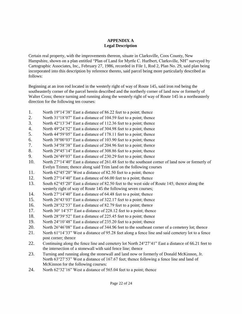
Page 22 of 24
APPENDIX A
Legal Description
Certain real property, with the improvements thereon, situate in Clarksville, Coos County, New
Hampshire, shown on a plan entitled “Plan of Land for Myrtle C. Hurlbert, Clarksville, NH” surveyed by
Cartographic Associates, Inc., February 27, 1986, recorded in File 1, Rod 2, Plan No. 29, said plan being
incorporated into this description by reference thereto, said parcel being more particularly described as
follows:
Beginning at an iron rod located in the westerly right of way of Route 145, said iron rod being the
southeasterly corner of the parcel herein described and the northerly corner of land now or formerly of
Walter Cross; thence turning and running along the westerly right of way of Route 145 in a northeasterly
direction for the following ten courses:
1. North 19°14’38” East a distance of 86.22 feet to a point; thence
2. North 31°18’07” East a distance of 104.59 feet to a point; thence
3. North 42°13’34” East a distance of 112.36 feet to a point; thence
4. North 49°24’52” East a distance of 304.98 feet to a point; thence
5. North 44°59’05” East a distance of 178.11 feet to a point; thence
6. North 38°00’03” East a distance of 103.90 feet to a point; thence
7. North 34°58’38” East a distance of 204.96 feet to a point; thence
8. North 29°45’14” East a distance of 308.86 feet to a point; thence
9. North 26°49’03” East a distance of 230.29 feet to a point; thence
10. North 27°14’40” East a distance of 261.48 feet to the southeast corner of land now or formerly of
Evelyn Trimm; thence along said Trim land on the following courses
11. North 62°45’20” West a distance of 82.50 feet to a point; thence
12. North 27°14’40” East a distance of 66.00 feet to a point; thence
13. South 62°45’20” East a distance of 82.50 feet to the west side of Route 145; thence along the
westerly right of way of Route 145 the following seven courses;
14. North 27°14’40” East a distance of 64.48 feet to a point; thence
15. North 26°43’03” East a distance of 322.17 feet to a point; thence
16. North 28°32’53” East a distance of 82.79 feet to a point; thence
17. North 30° 14’57” East a distance of 228.12 feet to a point; thence
18. North 28°39’52” East a distance of 225.45 feet to a point; thence
19. North 24°10’48” East a distance of 235.20 feet to a point; thence
20. North 26°46’08” East a distance of 344.96 feet to the southeast corner of a cemetery lot; thence
21. North 61°14’33” West a distance of 95.28 feet along a fence line and said cemetery lot to a fence
post corner; thence
22. Continuing along the fence line and cemetery lot North 24°27’41” East a distance of 66.21 feet to
the intersection of a stonewall with said fence line; thence
23. Turning and running along the stonewall and land now or formerly of Donald McKinnon, Jr.
North 63°27’53” West a distance of 167.67 feet; thence following a fence line and land of
McKinnon for the following courses:
24. North 62°32’16” West a distance of 565.04 feet to a point; thence
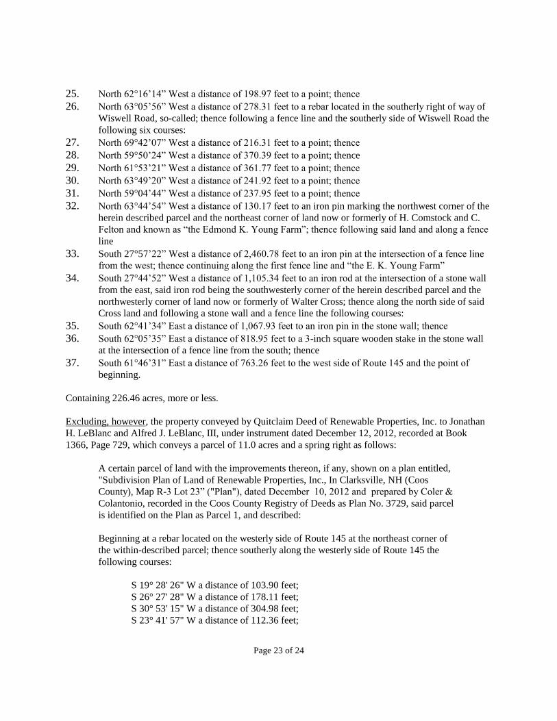
Page 23 of 24
25. North 62°16’14” West a distance of 198.97 feet to a point; thence
26. North 63°05’56” West a distance of 278.31 feet to a rebar located in the southerly right of way of
Wiswell Road, so-called; thence following a fence line and the southerly side of Wiswell Road the
following six courses:
27. North 69°42’07” West a distance of 216.31 feet to a point; thence
28. North 59°50’24” West a distance of 370.39 feet to a point; thence
29. North 61°53’21” West a distance of 361.77 feet to a point; thence
30. North 63°49’20” West a distance of 241.92 feet to a point; thence
31. North 59°04’44” West a distance of 237.95 feet to a point; thence
32. North 63°44’54” West a distance of 130.17 feet to an iron pin marking the northwest corner of the
herein described parcel and the northeast corner of land now or formerly of H. Comstock and C.
Felton and known as “the Edmond K. Young Farm”; thence following said land and along a fence
line
33. South 27°57’22” West a distance of 2,460.78 feet to an iron pin at the intersection of a fence line
from the west; thence continuing along the first fence line and “the E. K. Young Farm”
34. South 27°44’52” West a distance of 1,105.34 feet to an iron rod at the intersection of a stone wall
from the east, said iron rod being the southwesterly corner of the herein described parcel and the
northwesterly corner of land now or formerly of Walter Cross; thence along the north side of said
Cross land and following a stone wall and a fence line the following courses:
35. South 62°41’34” East a distance of 1,067.93 feet to an iron pin in the stone wall; thence
36. South 62°05’35” East a distance of 818.95 feet to a 3-inch square wooden stake in the stone wall
at the intersection of a fence line from the south; thence
37. South 61°46’31” East a distance of 763.26 feet to the west side of Route 145 and the point of
beginning.
Containing 226.46 acres, more or less.
Excluding, however, the property conveyed by Quitclaim Deed of Renewable Properties, Inc. to Jonathan
H. LeBlanc and Alfred J. LeBlanc, III, under instrument dated December 12, 2012, recorded at Book
1366, Page 729, which conveys a parcel of 11.0 acres and a spring right as follows:
A certain parcel of land with the improvements thereon, if any, shown on a plan entitled,
"Subdivision Plan of Land of Renewable Properties, Inc., In Clarksville, NH (Coos
County), Map R-3 Lot 23” ("Plan"), dated December 10, 2012 and prepared by Coler &
Colantonio, recorded in the Coos County Registry of Deeds as Plan No. 3729, said parcel
is identified on the Plan as Parcel 1, and described:
Beginning at a rebar located on the westerly side of Route 145 at the northeast corner of
the within-described parcel; thence southerly along the westerly side of Route 145 the
following courses:
S 19° 28' 26" W a distance of 103.90 feet;
S 26° 27' 28" W a distance of 178.11 feet;
S 30° 53' 15" W a distance of 304.98 feet;
S 23° 41' 57" W a distance of 112.36 feet;
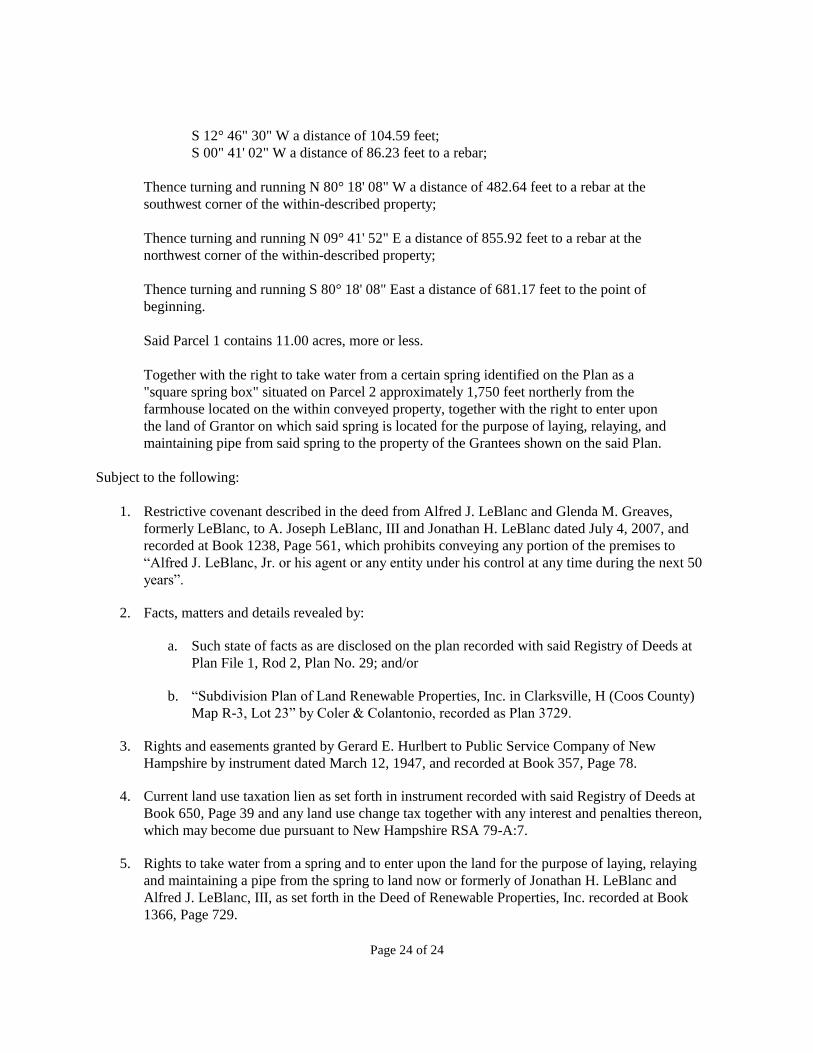
Page 24 of 24
S 12° 46" 30" W a distance of 104.59 feet;
S 00" 41' 02" W a distance of 86.23 feet to a rebar;
Thence turning and running N 80° 18' 08" W a distance of 482.64 feet to a rebar at the
southwest corner of the within-described property;
Thence turning and running N 09° 41' 52" E a distance of 855.92 feet to a rebar at the
northwest corner of the within-described property;
Thence turning and running S 80° 18' 08" East a distance of 681.17 feet to the point of
beginning.
Said Parcel 1 contains 11.00 acres, more or less.
Together with the right to take water from a certain spring identified on the Plan as a
"square spring box" situated on Parcel 2 approximately 1,750 feet northerly from the
farmhouse located on the within conveyed property, together with the right to enter upon
the land of Grantor on which said spring is located for the purpose of laying, relaying, and
maintaining pipe from said spring to the property of the Grantees shown on the said Plan.
Subject to the following:
1. Restrictive covenant described in the deed from Alfred J. LeBlanc and Glenda M. Greaves,
formerly LeBlanc, to A. Joseph LeBlanc, III and Jonathan H. LeBlanc dated July 4, 2007, and
recorded at Book 1238, Page 561, which prohibits conveying any portion of the premises to
“Alfred J. LeBlanc, Jr. or his agent or any entity under his control at any time during the next 50
years”.
2. Facts, matters and details revealed by:
a. Such state of facts as are disclosed on the plan recorded with said Registry of Deeds at
Plan File 1, Rod 2, Plan No. 29; and/or
b. “Subdivision Plan of Land Renewable Properties, Inc. in Clarksville, H (Coos County)
Map R-3, Lot 23” by Coler & Colantonio, recorded as Plan 3729.
3. Rights and easements granted by Gerard E. Hurlbert to Public Service Company of New
Hampshire by instrument dated March 12, 1947, and recorded at Book 357, Page 78.
4. Current land use taxation lien as set forth in instrument recorded with said Registry of Deeds at
Book 650, Page 39 and any land use change tax together with any interest and penalties thereon,
which may become due pursuant to New Hampshire RSA 79-A:7.
5. Rights to take water from a spring and to enter upon the land for the purpose of laying, relaying
and maintaining a pipe from the spring to land now or formerly of Jonathan H. LeBlanc and
Alfred J. LeBlanc, III, as set forth in the Deed of Renewable Properties, Inc. recorded at Book
1366, Page 729.