minerals and waste site monitoring report - … · darney sandstone quarry minerals and waste site...
TRANSCRIPT
Darney Sandstone Quarry Minerals and Waste Site Monitoring Report
Inspection Date: 16 December 2013 Report Reference: DARN -13/14 - 03
Tel: 01670 625553 E-mail: [email protected]
Strategic and Urban Development Management Team Local Services
Northumberland County Council County Hall, Morpeth
Northumberland NE61 2EF
- 1 - Minerals and Waste Site Monitoring
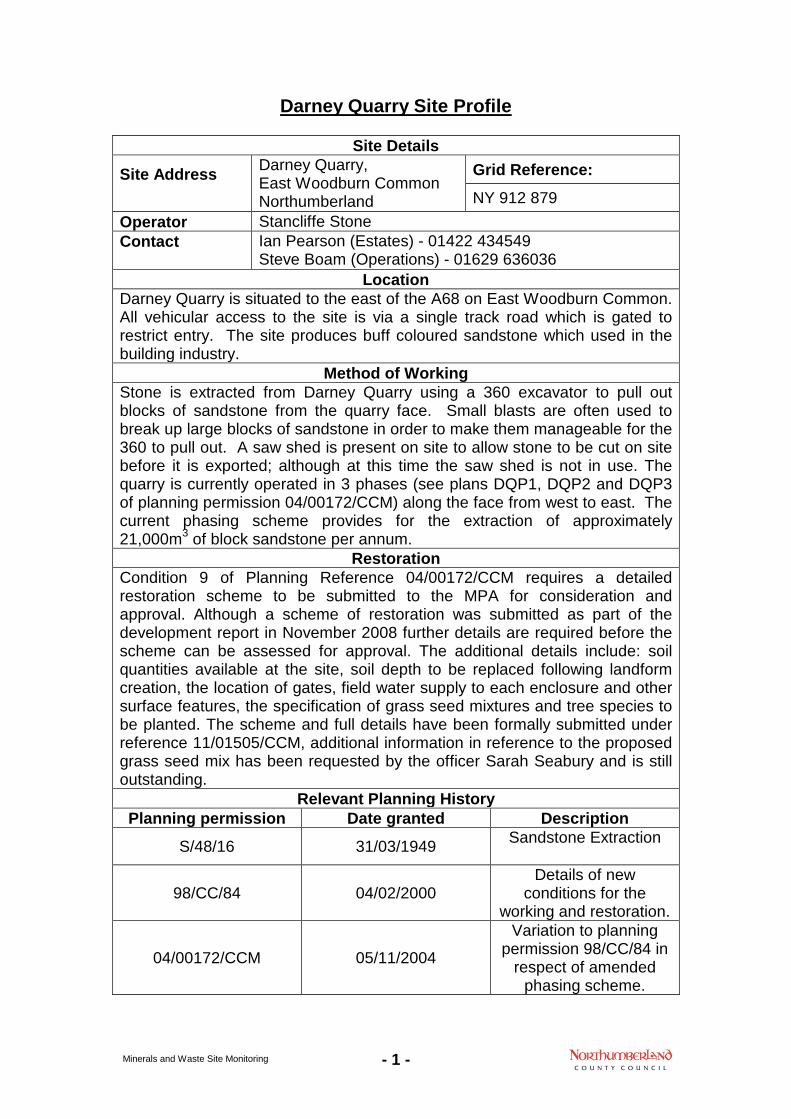
Darney Quarry Site Profile
Site Details
Site Address
Darney Quarry, East Woodburn Common Northumberland
Grid Reference:
NY 912 879 Operator Stancliffe Stone Contact
Ian Pearson (Estates) - 01422 434549 Steve Boam (Operations) - 01629 636036
Location Darney Quarry is situated to the east of the A68 on East Woodburn Common. All vehicular access to the site is via a single track road which is gated to restrict entry. The site produces buff coloured sandstone which used in the building industry.
Method of Working Stone is extracted from Darney Quarry using a 360 excavator to pull out blocks of sandstone from the quarry face. Small blasts are often used to break up large blocks of sandstone in order to make them manageable for the 360 to pull out. A saw shed is present on site to allow stone to be cut on site before it is exported; although at this time the saw shed is not in use. The quarry is currently operated in 3 phases (see plans DQP1, DQP2 and DQP3 of planning permission 04/00172/CCM) along the face from west to east. The current phasing scheme provides for the extraction of approximately 21,000m3 of block sandstone per annum.
Restoration Condition 9 of Planning Reference 04/00172/CCM requires a detailed restoration scheme to be submitted to the MPA for consideration and approval. Although a scheme of restoration was submitted as part of the development report in November 2008 further details are required before the scheme can be assessed for approval. The additional details include: soil quantities available at the site, soil depth to be replaced following landform creation, the location of gates, field water supply to each enclosure and other surface features, the specification of grass seed mixtures and tree species to be planted. The scheme and full details have been formally submitted under reference 11/01505/CCM, additional information in reference to the proposed grass seed mix has been requested by the officer Sarah Seabury and is still outstanding.
Relevant Planning History Planning permission Date granted Description
S/48/16 31/03/1949 Sandstone Extraction
98/CC/84 04/02/2000 Details of new
conditions for the working and restoration.
04/00172/CCM 05/11/2004
Variation to planning permission 98/CC/84 in
respect of amended phasing scheme.
- 2 - Minerals and Waste Site Monitoring
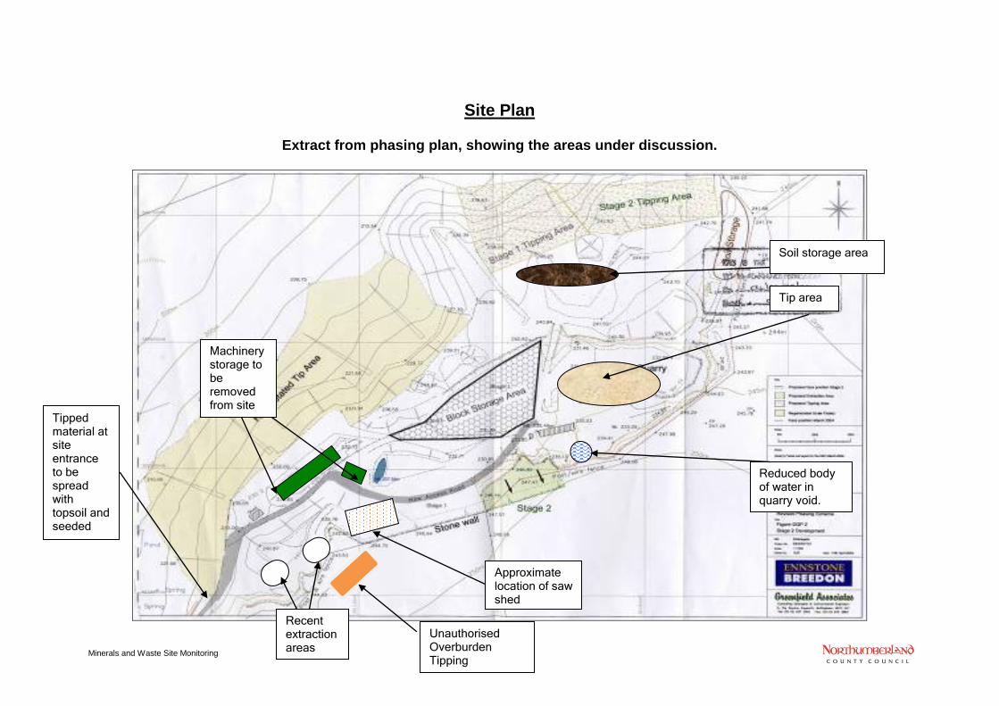
Site Plan
Extract from phasing plan, showing the areas under discussion.
Recent extraction areas
Machinery storage to be removed from site
Approximate location of saw shed
Reduced body of water in quarry void.
Tip area
Tipped material at site entrance to be spread with topsoil and seeded
Soil storage area
Unauthorised Overburden Tipping
- 3 - Minerals and Waste Site Monitoring
Site Report
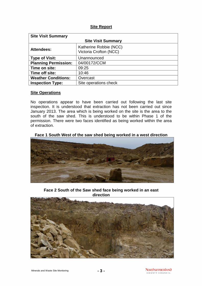
Site Operations No operations appear to have been carried out following the last site inspection. It is understood that extraction has not been carried out since January 2013. The area which is being worked on the site is the area to the south of the saw shed. This is understood to be within Phase 1 of the permission. There were two faces identified as being worked within the area of extraction.
Face 1 South West of the saw shed being worked in a west direction
Face 2 South of the Saw shed face being worked in an east direction
Site Visit Summary Site Visit Summary
Attendees: Katherine Robbie (NCC) Victoria Crofton (NCC)
Type of Visit: Unannounced Planning Permission: 04/00172/CCM Time on site: 09:25 Time off site: 10:46 Weather Conditions: Overcast Inspection Type: Site operations check
- 4 - Minerals and Waste Site Monitoring
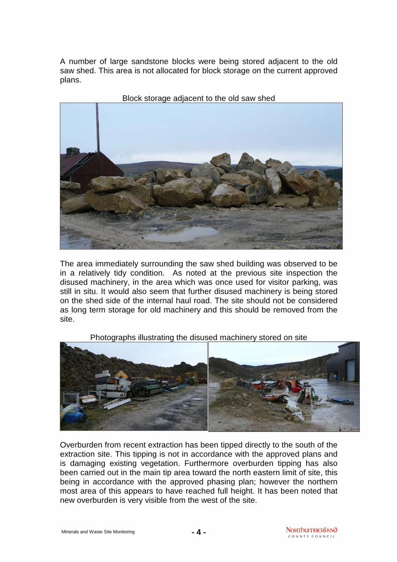
A number of large sandstone blocks were being stored adjacent to the old saw shed. This area is not allocated for block storage on the current approved plans.
Block storage adjacent to the old saw shed
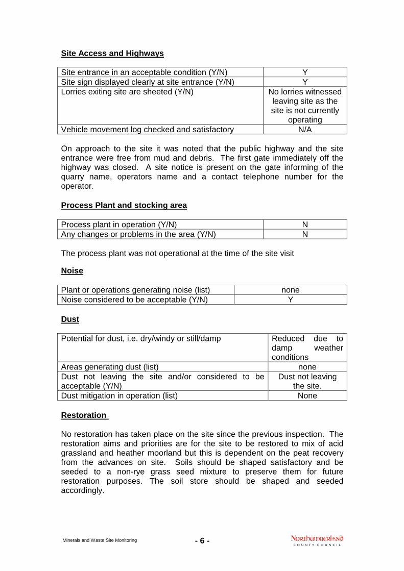
The area immediately surrounding the saw shed building was observed to be in a relatively tidy condition. As noted at the previous site inspection the disused machinery, in the area which was once used for visitor parking, was still in situ. It would also seem that further disused machinery is being stored on the shed side of the internal haul road. The site should not be considered as long term storage for old machinery and this should be removed from the site.
Photographs illustrating the disused machinery stored on site
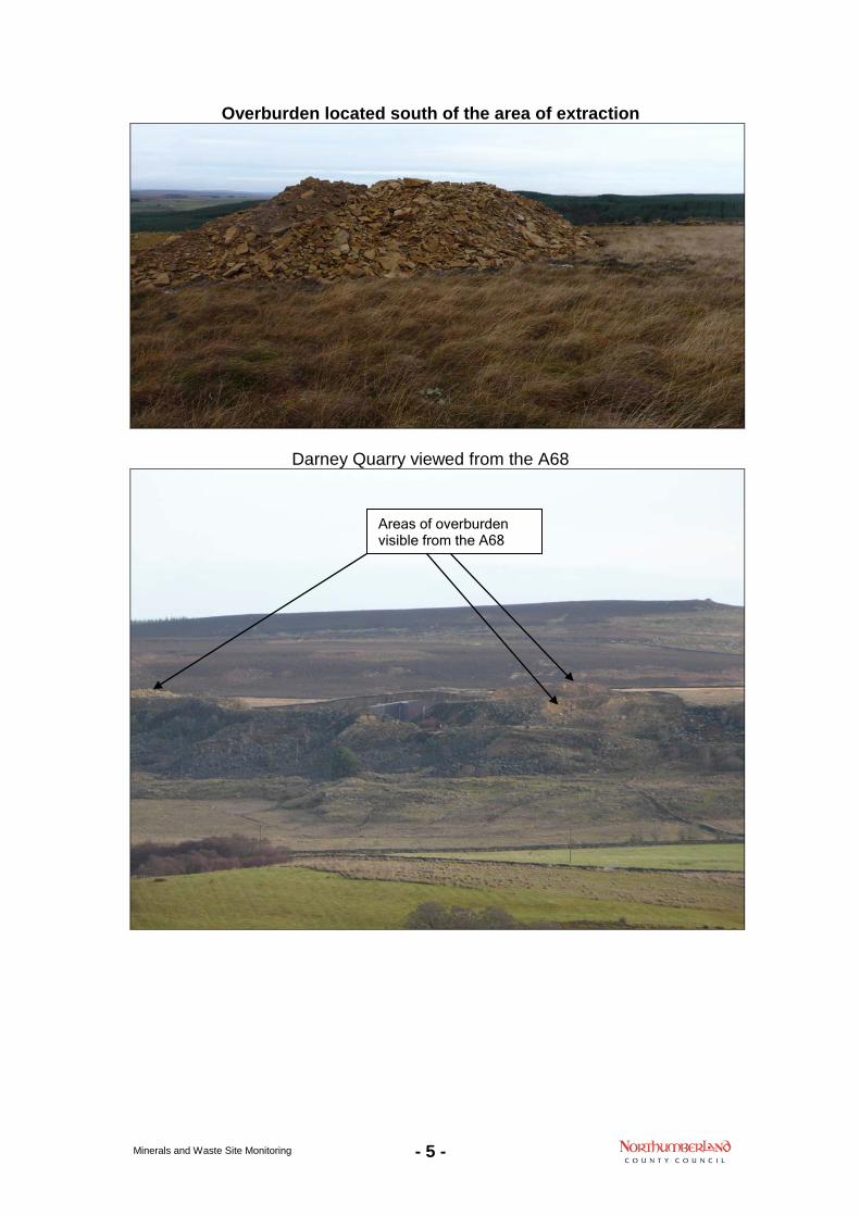
Overburden from recent extraction has been tipped directly to the south of the extraction site. This tipping is not in accordance with the approved plans and is damaging existing vegetation. Furthermore overburden tipping has also been carried out in the main tip area toward the north eastern limit of site, this being in accordance with the approved phasing plan; however the northern most area of this appears to have reached full height. It has been noted that new overburden is very visible from the west of the site.
- 5 - Minerals and Waste Site Monitoring
Overburden located south of the area of extraction
Darney Quarry viewed from the A68
Areas of overburden visible from the A68
- 6 - Minerals and Waste Site Monitoring
Site Access and Highways Site entrance in an acceptable condition (Y/N) Y Site sign displayed clearly at site entrance (Y/N) Y Lorries exiting site are sheeted (Y/N) No lorries witnessed
leaving site as the site is not currently
operating Vehicle movement log checked and satisfactory N/A On approach to the site it was noted that the public highway and the site entrance were free from mud and debris. The first gate immediately off the highway was closed. A site notice is present on the gate informing of the quarry name, operators name and a contact telephone number for the operator. Process Plant and stocking area Process plant in operation (Y/N) N Any changes or problems in the area (Y/N) N The process plant was not operational at the time of the site visit Noise Plant or operations generating noise (list) none Noise considered to be acceptable (Y/N) Y Dust Potential for dust, i.e. dry/windy or still/damp Reduced due to
damp weather conditions
Areas generating dust (list) none Dust not leaving the site and/or considered to be acceptable (Y/N)
Dust not leaving the site.
Dust mitigation in operation (list) None Restoration No restoration has taken place on the site since the previous inspection. The restoration aims and priorities are for the site to be restored to mix of acid grassland and heather moorland but this is dependent on the peat recovery from the advances on site. Soils should be shaped satisfactory and be seeded to a non-rye grass seed mixture to preserve them for future restoration purposes. The soil store should be shaped and seeded accordingly.
- 7 - Minerals and Waste Site Monitoring
Photograph showing the soil storage.
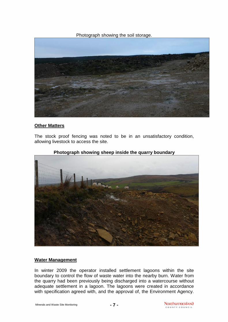
Other Matters The stock proof fencing was noted to be in an unsatisfactory condition, allowing livestock to access the site.
Photograph showing sheep inside the quarry boundary
Water Management In winter 2009 the operator installed settlement lagoons within the site boundary to control the flow of waste water into the nearby burn. Water from the quarry had been previously being discharged into a watercourse without adequate settlement in a lagoon. The lagoons were created in accordance with specification agreed with, and the approval of, the Environment Agency.
- 8 - Minerals and Waste Site Monitoring
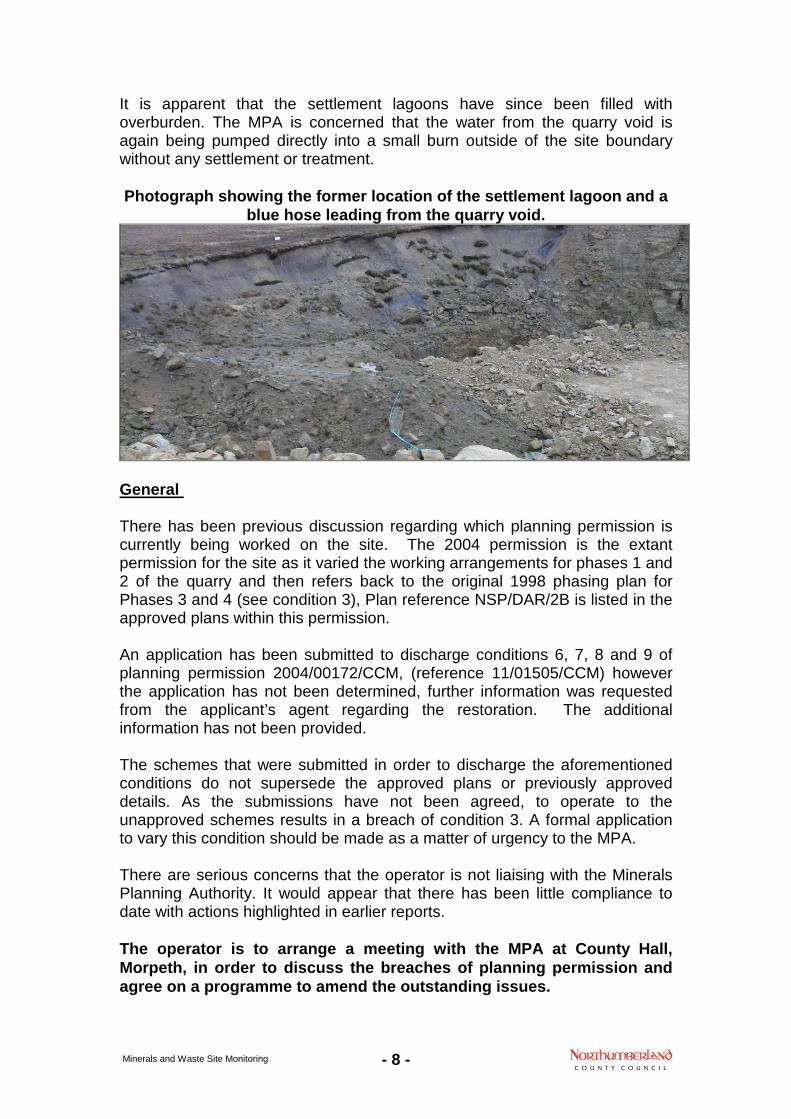
It is apparent that the settlement lagoons have since been filled with overburden. The MPA is concerned that the water from the quarry void is again being pumped directly into a small burn outside of the site boundary without any settlement or treatment. Photograph showing the former location of the settlement lagoon and a
blue hose leading from the quarry void.
General There has been previous discussion regarding which planning permission is currently being worked on the site. The 2004 permission is the extant permission for the site as it varied the working arrangements for phases 1 and 2 of the quarry and then refers back to the original 1998 phasing plan for Phases 3 and 4 (see condition 3), Plan reference NSP/DAR/2B is listed in the approved plans within this permission. An application has been submitted to discharge conditions 6, 7, 8 and 9 of planning permission 2004/00172/CCM, (reference 11/01505/CCM) however the application has not been determined, further information was requested from the applicant’s agent regarding the restoration. The additional information has not been provided. The schemes that were submitted in order to discharge the aforementioned conditions do not supersede the approved plans or previously approved details. As the submissions have not been agreed, to operate to the unapproved schemes results in a breach of condition 3. A formal application to vary this condition should be made as a matter of urgency to the MPA. There are serious concerns that the operator is not liaising with the Minerals Planning Authority. It would appear that there has been little compliance to date with actions highlighted in earlier reports. The operator is to arrange a meeting with the MPA at County Hall, Morpeth, in order to discuss the breaches of planning permission and agree on a programme to amend the outstanding issues.
- 9 - Minerals and Waste Site Monitoring
Failure to contact the MPA within 28 days of receipt of the monitoring report may result in the commencement of formal enforcement action. Condition Action Timescale Priority 3 The site is now not in accordance
with the approved plans since the construction of the saw shed. A variation of condition is required.
31 December 2013
6 The information submitted as part of application 11/01505/CCM is unacceptable and will need to be resubmitted in order to discharge this condition
Prior to commencement of Phases 3 and 4
The details submitted as part of application 11/01505/CCM does not reflect accurately how the quarry has been worked and does not cover the 3 year period from 2011 to 2104 as required by the report and is therefore unacceptable to discharge this condition.
31 December 2013
9 The details submitted as part of application 11/01505/CCM does not adequately address the requirements of this condition which should be a detailed rather than indicative restoration scheme for the site. This needs to be submitted for approval urgently in order to comply with this condition
31 December 2013
Removal of disused machinery from site or storage within the saw shed.
As soon as practically possible
Report sign off
Inspecting Officer: Name:
Victoria Crofton
Signed:
Date:
18 December 2013
- 10 - Minerals and Waste Site Monitoring
Planning Permission 2004/00172/CCM Conditions 1. Unless otherwise agreed in writing with the Mineral Planning Authority,
extraction of minerals shall cease by 31 December 2041 and restoration shall be completed by 31 December 2042, including the removal of all buildings, plant and machinery.
2. The area of the permission is defined by the area edged red on Plan
NSP/DAR/2B, Site Plan and Planning Permission Area Plan, as submitted with planning application 98/CC/84
3. The quarry shall be worked in accordance with the phasing proposed on the
following plans: • Figure DQP1, DQP2, and DQP3 submitted under planning reference
04/00172/CCM • NSP/DAR/2B in respect of Phase 3 and Phase 4
4. The lateral extent of the quarry void shall not exceed the limit defined on Plan
NSP/DAR/2B as submitted under planning reference 98/CC/84 unless it is in relation to Stage 1A on Figure DQP1 as submitted under planning reference 04/00172/CCM. The vertical extent of extraction shall not be lower than 220 metres AOD unless otherwise agreed in writing by the Mineral Planning Authority.
5. Upon completion of the landform agreed pursuant to condition 9, any further
waste arising from phases 3 and 4 shall be placed within the quarry void unless otherwise agreed in writing with the Mineral Planning Authority.
6. Prior to commencement of extraction in phases 3 and 4 identified on Plan
NSP/DAR/2B as submitted under planning reference 98/CC/84, a working programme shall be submitted for the written approval of the Mineral Planning Authority. Such a scheme shall be fully implemented unless otherwise agreed in writing by the Mineral Planning Authority. Such a scheme will provide for:
i) the removal and storage of overburden and/or tipped
material (if appropriate); ii) a programme of mineral extraction; iii) the deposition of mineral waste arisings; and iv) landscaping.
7. Unless otherwise agreed in writing by the Mineral Planning Authority, the
operator shall submit to the Mineral Planning Authority a formal report which shall detail all mineral working and ancillary operations:
i) undertaken at the site under the terms of this
permission during the immediately preceding 3 years; and
ii) proposed for the following 3 years.
- 11 - Minerals and Waste Site Monitoring
The formal report shall be first submitted on 1 October 2007 and each subsequent third anniversary thereafter.
8. Each formal report submitted in accordance with Condition 7 shall indicate by
reference to a plan the areas within which the following operations have taken place during the previous 3 years and are proposed during the forthcoming 3 years: i) mineral extraction; ii) deposition of mineral waste arising;
iii) removal and storage of overburden and waste material (if appropriate);
iv) surface water drainage works (if appropriate); v) restoration and aftercare; and vi) landscaping.
Restoration 9. By 1 October 2007 unless otherwise agreed by the Mineral Planning
Authority, a detailed design for the restoration of the site to amenity use and open moorland shall be submitted for the written approval of the Mineral Planning Authority. Such a scheme shall be fully implemented unless otherwise agreed by in writing the Mineral Planning Authority. This scheme shall provide for the final restoration of the site and shall include measures to rehabilitate the quarry void, access roads and land used for ancillary purposes. If in the reasonable opinion of the Mineral Planning Authority, the final restoration shall not be achieved by 31 December 2042, a revised final restoration scheme shall be submitted for approval of the Mineral Planning Authority on any 7th anniversary of 1 October 2007.
Aftercare 10. An aftercare scheme, requiring that such steps as may be necessary to bring
the land restored under Conditions 9 to the required standard, shall be submitted for the approval of the Mineral Planning Authority not later than one year before the cessation of working and upon approval shall be implemented in accordance with Condition 9, unless otherwise agreed in writing with the Mineral Planning Authority. Such a scheme shall provide for the following matters:
a) the maintenance of landscaped areas; and b) the maintenance of the nature conservation interest of the site.
Hours of Operation 11. No operations other than pumping and maintenance, testing and servicing of
plant and machinery, shall be carried out on Bank Holidays and public holidays or at any other time other time other than between the following times:
i) 0700 hours to 1900 hours Monday to Friday; and ii) 0700 hours to 1300 hours on Saturdays.
- 12 - Minerals and Waste Site Monitoring
Access and Traffic 12. All vehicles and other traffic entering or leaving the site shall do so only by
way of the existing access or such other access as may be approved in writing by the Mineral Planning Authority.
13. No commercial vehicles shall enter the public highway unless their wheels
and chassis are sufficiently clean to prevent material being deposited on the highway.
14. No more than 15 loaded vehicles shall leave the site on any working day
unless otherwise agreed in writing with the Mineral Planning Authority. A record shall be kept of the numbers of lorry loads leaving each day and such records produced to the Mineral Planning Authority at their request.
Surface Water Drainage and Groundwater Protection 15. Any facilities for the storage of oils, fuels or chemicals shall be sited on
impervious bases and surrounded by impervious bund walls. The volume of the bunded compound should be at least equivalent to the capacity of the tank plus 10%. If there is multiple tankage, the compound should be at least equivalent to the capacity of the largest tank, or the capacity of interconnected tanks, plus 10%. All filling points, vents, gauges and sight glasses must be located within the bund. The drainage system of the bund shall be sealed with no discharge to any watercourse, land or underground strata. Associated pipework should be located above ground and protected from accidental damage. All filling points and tank overflow pipe outlets should be detailed to discharge downwards into the bund.
16. There shall be no discharge of foul or contaminated drainage from the site
into either groundwater or any surface waters, whether direct or via soakaways.
Plant and Machinery 17. All vehicles, plant and machinery operated within the site shall be maintained
in accordance with the manufacturers’ specification at all times, and shall be fitted with the use of effective silencers.
Landscaping 18. No soils or turf shall be removed from the site. 19. All operations involving the removal and placement of soils shall be carried
out only when such material is deemed to be suitably dry and friable. Archaeology 20. No development shall take place within phase 3b and all of phase 4, until the
operator has secured the implementation of a phased programme of archaeological works, to include evaluation and preservation by record of threatened archaeological remains, as contained in outline in the report prepared by MAP Archaeological Consultants Limited dated November 1999. And, furthermore, that a programme of post-excavation analysis, according to

- 13 - Minerals and Waste Site Monitoring
the principles in Management of Archaeological Projects (English Heritage 1991) is completed and a report submitted for publication not less than 18 months after completion of fieldwork.