military topographic map ii b182036 … military...military topographic map ii b182036. student...
TRANSCRIPT
UNITED STATES MARINE CORPS THE BASIC SCHOOL
MARINE CORPS TRAINING COMMAND CAMP BARRETT, VIRGINIA 22134-5019
MILITARY TOPOGRAPHIC MAP II
B182036 STUDENT HANDOUT
Basic Officer Course
B182036 Military Topographic Map II
2 Basic Officer Course
Military Topographic Map II
Introduction In Military Topographic Map I, you were introduced to the
map, protractor, and lensatic compass—the tools required to be successful in land navigation. In addition, you were taught that the ability to interpret the map and “read the terrain” were additional tools you would need to be absolutely certain of your position at all times. This lesson will aid your ability to interpret the map and “read the terrain”. These abilities, combined with the tools of land navigation, will set you on the path to being a successful land navigator.
Importance Land navigation is a skill-set which takes time and practice
in order to become proficient and confident. Basic mastery of map interpretation and terrain analysis (“reading the terrain”) is essential.
In This Lesson This lesson is devoted to two of the most basic tools: map
interpretation and terrain analysis. The intent of this lesson is to ensure you are prepared for practical application.
This lesson covers the following topics:
Topic Page
Water Features 4 Vegetation Features 7 Manmade Features 8 Using Features as Aids to Navigation 10 Requirement 1 Review Questions 12 Requirement 2 Review Questions 13 Requirement 1 Answers 13 Requirement 2 Answers Error!
Bookmark not
defined. Terrain Analysis 13 Requirement 3 Review Questions 19 Requirement 4 Review Questions 21 Requirement 3 Answers 23 Requirement 4 Answers 24 Summary 25 References 25 Glossary of Terms and Acronyms 25 Notes 25

B182036 Military Topographic Map II
3 Basic Officer Course
Learning Objectives Terminal Learning Objectives
TBS-PAT-1002 Given a military topographic map, protractor, lensatic compass, and objective, navigate with a map and compass, to arrive within 100 meters of the objective.

B182036 Military Topographic Map II
4 Basic Officer Course
Military Topographic Map II (Continued)
Learning Objectives (Continued)
Enabling Learning Objectives TBS-PAT-1002a Given a military topographic map, identify marginal information, without error. TBS-PAT-1002b Given a military topographic map, identify contour lines, without error. TBS-PAT-1002c Given a military topographic map, identify terrain features, without error. TBS-PAT-1002j Given a military topographic map, lensatic compass, orient a map, without error.
B182036 Military Topographic Map II
5 Basic Officer Course
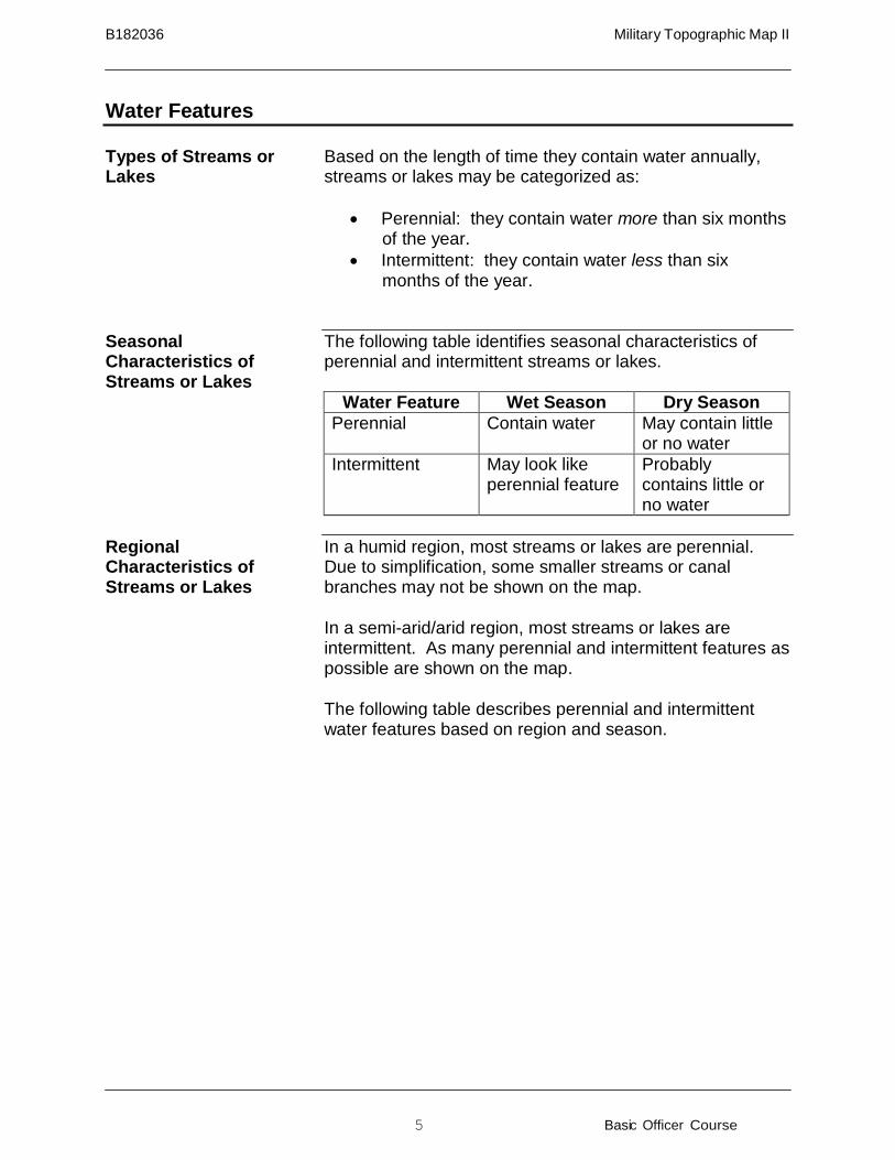
Water Features
Types of Streams or Lakes
Based on the length of time they contain water annually, streams or lakes may be categorized as:
• Perennial: they contain water more than six months of the year.
• Intermittent: they contain water less than six months of the year.
Seasonal Characteristics of Streams or Lakes
The following table identifies seasonal characteristics of perennial and intermittent streams or lakes.
Water Feature Wet Season Dry Season Perennial Contain water May contain little
or no water Intermittent May look like
perennial feature Probably contains little or no water
Regional Characteristics of Streams or Lakes
In a humid region, most streams or lakes are perennial. Due to simplification, some smaller streams or canal branches may not be shown on the map. In a semi-arid/arid region, most streams or lakes are intermittent. As many perennial and intermittent features as possible are shown on the map. The following table describes perennial and intermittent water features based on region and season.
B182036 Military Topographic Map II
6 Basic Officer Course
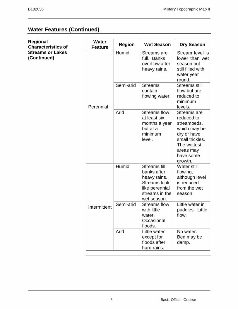
Water Feature
Region
Wet Season
Dry Season Perennial
Humid Streams are full. Banks overflow after heavy rains.
Stream level is lower than wet season but still filled with water year round.
Semi-arid Streams contain flowing water.
Streams still flow but are reduced to minimum levels.
Arid Streams flow at least six months a year but at a minimum level.
Streams are reduced to streambeds, which may be dry or have small trickles. The wettest areas may have some growth.
Intermittent
Humid Streams fill banks after heavy rains. Streams look like perennial streams in the wet season.
Water still flowing, although level is reduced from the wet season.
Semi-arid Streams flow with little water. Occasional floods.
Little water in puddles. Little flow.
Arid Little water except for floods after hard rains.
No water. Bed may be damp.
Water Features (Continued)
Regional Characteristics of Streams or Lakes (Continued)
B182036 Military Topographic Map II
7 Basic Officer Course
Water Features (Continued)
Using Season and Region as Aids to Terrain Analysis
Generally, if a feature contains water during the dry season (when you would least expect to find water), you can assume that it is a perennial water feature, especially in arid and semi-arid regions. If a feature contains no water during the wet season (when you would expect to find water), you can assume that the feature will be portrayed on the map as an intermittent water feature, especially in arid and semi-arid regions. In a humid region this feature may not be portrayed on the map at all.
Map Design Characteristics and Criteria
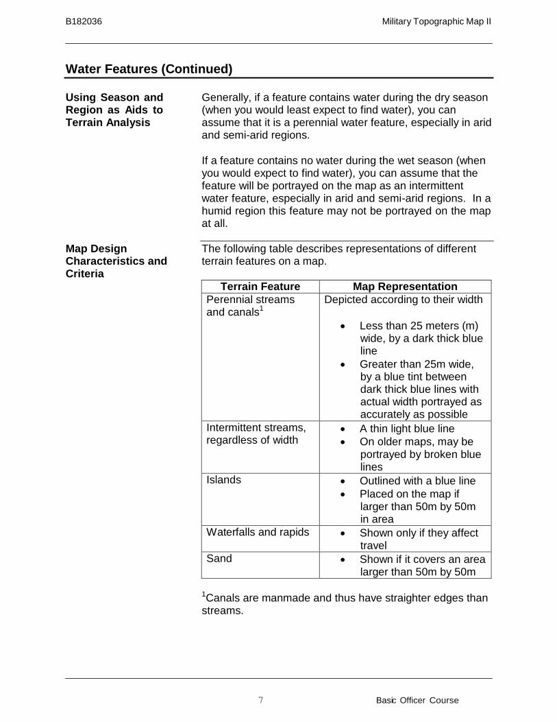
The following table describes representations of different terrain features on a map.
Terrain Feature Map Representation Perennial streams and canals1
Depicted according to their width
• Less than 25 meters (m) wide, by a dark thick blue line
• Greater than 25m wide, by a blue tint between dark thick blue lines with actual width portrayed as accurately as possible
Intermittent streams, regardless of width
• A thin light blue line • On older maps, may be
portrayed by broken blue lines
Islands • Outlined with a blue line • Placed on the map if
larger than 50m by 50m in area
Waterfalls and rapids • Shown only if they affect travel
Sand • Shown if it covers an area larger than 50m by 50m
1Canals are manmade and thus have straighter edges than streams.
B182036 Military Topographic Map II
8 Basic Officer Course
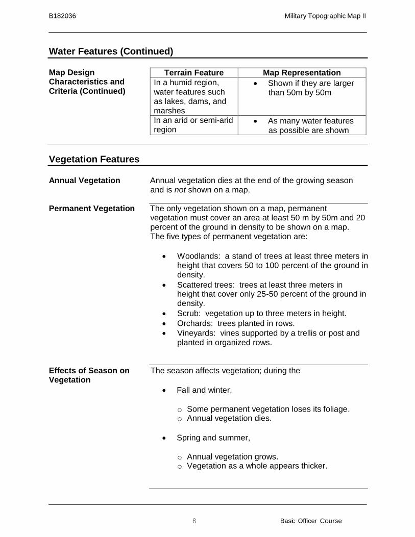
Terrain Feature Map Representation In a humid region, water features such as lakes, dams, and marshes
• Shown if they are larger than 50m by 50m
In an arid or semi-arid region
• As many water features as possible are shown
Water Features (Continued)
Map Design Characteristics and Criteria (Continued)
Vegetation Features
Annual Vegetation Annual vegetation dies at the end of the growing season
and is not shown on a map. Permanent Vegetation The only vegetation shown on a map, permanent
vegetation must cover an area at least 50 m by 50m and 20 percent of the ground in density to be shown on a map. The five types of permanent vegetation are:
• Woodlands: a stand of trees at least three meters in
height that covers 50 to 100 percent of the ground in density.
• Scattered trees: trees at least three meters in height that cover only 25-50 percent of the ground in density.
• Scrub: vegetation up to three meters in height. • Orchards: trees planted in rows. • Vineyards: vines supported by a trellis or post and
planted in organized rows. Effects of Season on Vegetation
The season affects vegetation; during the
• Fall and winter,
o Some permanent vegetation loses its foliage. o Annual vegetation dies.
• Spring and summer,
o Annual vegetation grows. o Vegetation as a whole appears thicker.
B182036 Military Topographic Map II
9 Basic Officer Course
Vegetation Features (Continued)
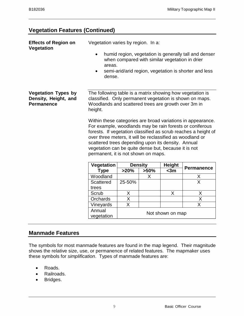
Effects of Region on Vegetation
Vegetation varies by region. In a:
• humid region, vegetation is generally tall and denser
when compared with similar vegetation in drier areas.
• semi-arid/arid region, vegetation is shorter and less dense.
Vegetation Types by Density, Height, and Permanence
The following table is a matrix showing how vegetation is classified. Only permanent vegetation is shown on maps. Woodlands and scattered trees are growth over 3m in height. Within these categories are broad variations in appearance. For example, woodlands may be rain forests or coniferous forests. If vegetation classified as scrub reaches a height of over three meters, it will be reclassified as woodland or scattered trees depending upon its density. Annual vegetation can be quite dense but, because it is not permanent, it is not shown on maps.
Vegetation
Type Density Height Permanence
>20% >50% <3m Woodland X X Scattered trees
25-50% X
Scrub X X X Orchards X X Vineyards X X Annual vegetation Not shown on map
Manmade Features
The symbols for most manmade features are found in the map legend. Their magnitude shows the relative size, use, or permanence of related features. The mapmaker uses these symbols for simplification. Types of manmade features are:
• Roads. • Railroads. • Bridges.

B182036 Military Topographic Map II
10 Basic Officer Course
Manmade Features (Continued)
• Power transmission lines. • Airfields. • Buildings.
Roads Roads are shown on a map with a variety of reddish-brown
or black lines. Their symbols vary with the type of surface. All paved roads in the real world are shown on the map. Dirt roads that are the only route to a mapped feature are shown on the map.
Railroads All railroads are shown on a map.
Bridges Bridges are shown on a map if they are longer than 50m.
Power Transmission Lines
Power transmission lines are shown if they do not clutter the map
Airfields All airfields are shown on a map. Airfields with a dirt or
grass surface are shown with dashed black lines; paved surfaces are shown with solid black lines.
Buildings If larger than 25m by 25m, buildings are shown to scale and
in exact size and shape. All buildings that are widely spaced are shown individually if they do not clutter the map. If buildings are close together, only some of the buildings are shown in order to simplify the amount of detail on a map.
B182036 Military Topographic Map II
11 Basic Officer Course
Using Water, Vegetation, and Manmade Features as Aids to Navigation
Be aware of the date of the map. The information the map provides is only as good as the date it was compiled.
Look for unique features such as power lines, lakes, prominent stands of vegetation, etc.
Confirm suspected location by matching the terrain seen in the real world with that depicted on the map. Actual landforms rarely change; however,
• Beavers can create ponds. • Man can:
o Cut down and plant new woodlands. o Build and destroy buildings. o Build, renovate, or remove roads, highways, power lines, etc.
• Trails and/or landing zones may:
o Be altered. o Become grown over. o Be created new.
Bottom line: Be certain of your position. Do not simply talk yourself into it!
B182036 Military Topographic Map II
12 Basic Officer Course
Requirement 1 Review Questions
Requirement 1 map: Margarita Peak, California, 1:50,000, Sheet 2550 IV, Series V795, Edition 9-NGA.
1. You are somewhere in the four grid square area defined by grids 6196, 6296,
6195, and 6295. You are on a piece of high ground at its highest point. An unimproved surface road is directly to the east. The ground to the west falls off to form a fairly large finger; smaller fingers are to the north and south. In addition, you can just make out, in the distance, a control tower in GS 6191 on a magnetic azimuth of 163°. What is the 8-digit grid coordinate of your position? Answer:
2. You are somewhere in the four grid square area defined by grids 6989, 7089,
6988, and 7088. It is springtime, and by the relative “greenness” of the vegetation, you note the area has received adequate rainfall. You are standing in a streambed that is 40m wide. To the north you see a road running at a slight angle (SE→NW) to your front. In the background, to the northeast, you see the top of a huge building that you estimate to be approximately 500m from your location. To the west you can see ground rising away from you some distance (approximately 300-500m) away. To the south you see a dirt road running from the southwest to the northeast (SW→NE) with a body of water behind it. What is the 6-digit grid coordinate of your position? Answer:
3. You are somewhere in the four grid square area defined by grids 6099, 6199,
6098, and 6198. It is mid-summer. A recent fire has blackened the area around you. You are standing in a dry streambed that runs from the southwest to the northeast (SW→NE) on a rough magnetic azimuth of 15°. To the west is a somewhat concave slope of considerable size. Due to the lack of vegetation, you can look north along the stream for a considerable distance, and you notice a fairly steep concave slope on the east side of the stream about 300m north of your position. The stream continues south at roughly a 190° azimuth. Considerable high ground is to the west and east. From the description given, what is the 6-digit grid coordinate of your position? Answer:
B182036 Military Topographic Map II
13 Basic Officer Course
Requirement 1 Answers
1.
61339570
2. 692886
3. 600984
Terrain Analysis
Map Design Guidelines When mapmakers design a map, they consider:
• Selection: Choosing features to be shown on the
map. Certain features will not be included in order to lessen the amount of detail included on the map.
• Classification: Grouping together of similar features. • Simplification: Reducing amount of detail on map.
For example, not every bend in a windy road or trail will be shown.
• Magnitude: Shows relative size, use, and permanence of related features.
Terrain Association Factors
Terrain Association Factors (Continued)
Each time you open a map to use it, you must consider the:
• Contour lines: They provide information on the
amount of detail shown on landforms. Contour lines are extremely important during the planning stage of any operation.
• Map date: The information the map provides is only as good as the date it was compiled. The older a map is, the more skeptical a planner needs to be about its accuracy.
• Map region: Knowing the region the map covers will provide a clearer idea of what you can expect to see in the real world and on the map.
• Season: The changing seasons will affect what you see in the real world and your ability to match what you see to the map.
B182036 Military Topographic Map II
14 Basic Officer Course
Describing Landforms When describing landforms, remember the acronym SOSES:
• Shape: the general form or outline of feature. • Orientation: the direction of the feature (N,S,E, or
W) with respect to your viewpoint. The orientation is either in line, across, or at an angle to your viewpoint (see following diagram).
• Size: the length or width of feature across its base. • Elevation: the height of landform above sea level or
a common datum. • Slope: steepness of landform’s sides.

B182036 Military Topographic Map II
15 Basic Officer Course
Terrain Analysis (Continued)
Describing Landforms, SOSES, Orientation (Continued)
Determining Elevation The following table lists one method for determining
elevation.
Step Action 1 Look at the contour interval. 2 From the designated point, find the nearest
index contour line. 3 Determine if the index contour line is up or
down slope from the designated point. 4 Count the number of contour lines from the
designated point to the index contour line. Multiply that number by the contour interval to calculate the change in elevation (up or down) from the designated point to the index contour line.
5 Add (or subtract) the change in elevation, as appropriate, to (or from) the index contour line.
6 If the designated point is between contour lines, add one-half of the contour interval to the lower contour line.
Other methods for determining elevation are:
• Bench marks. • Road intersections. • Other spot elevations.
B182036 Military Topographic Map II
16 Basic Officer Course
Terrain Analysis (Continued)
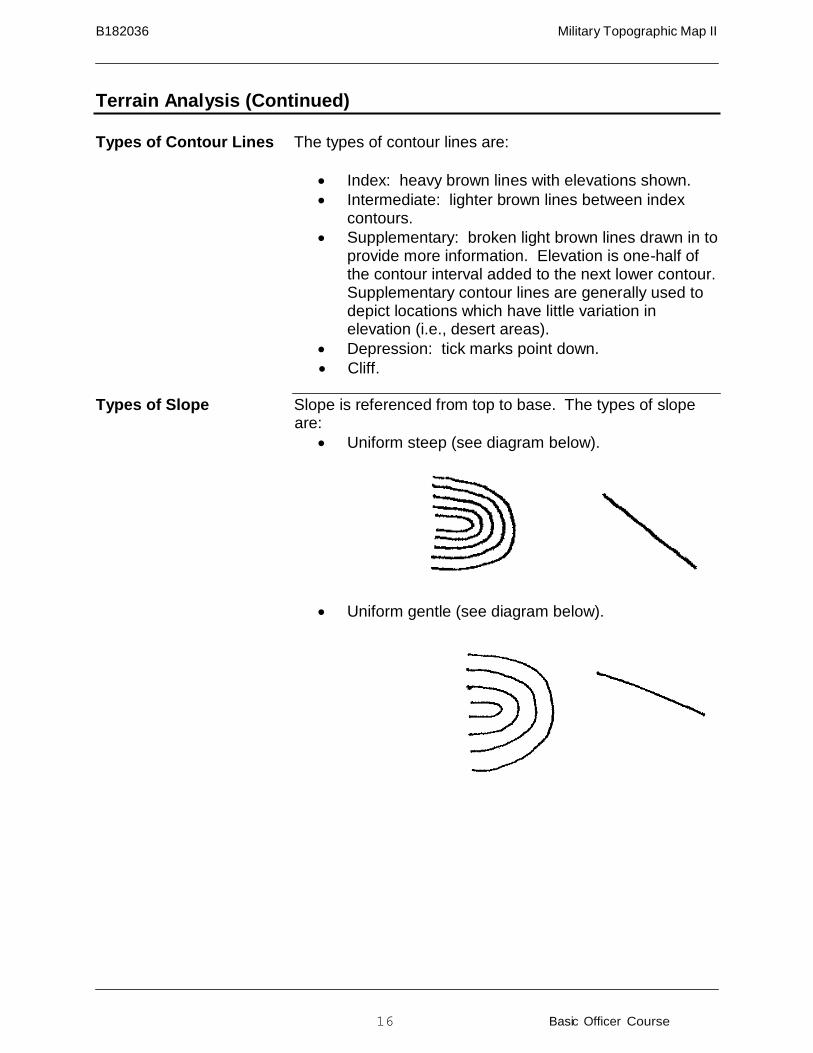
Types of Contour Lines The types of contour lines are:
• Index: heavy brown lines with elevations shown. • Intermediate: lighter brown lines between index
contours. • Supplementary: broken light brown lines drawn in to
provide more information. Elevation is one-half of the contour interval added to the next lower contour. Supplementary contour lines are generally used to depict locations which have little variation in elevation (i.e., desert areas).
• Depression: tick marks point down. • Cliff.
Types of Slope Slope is referenced from top to base. The types of slope
are: • Uniform steep (see diagram below).
• Uniform gentle (see diagram below).
B182036 Military Topographic Map II
17 Basic Officer Course
Terrain Analysis (Continued)
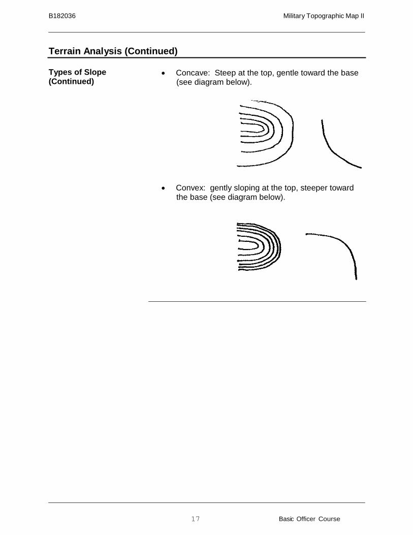
Types of Slope (Continued)
• Concave: Steep at the top, gentle toward the base (see diagram below).
• Convex: gently sloping at the top, steeper toward
the base (see diagram below).
18 Basic Officer Course
8182036 Military Topographic Map II
=
@)
-
-
Terrain Analysis (Continued)
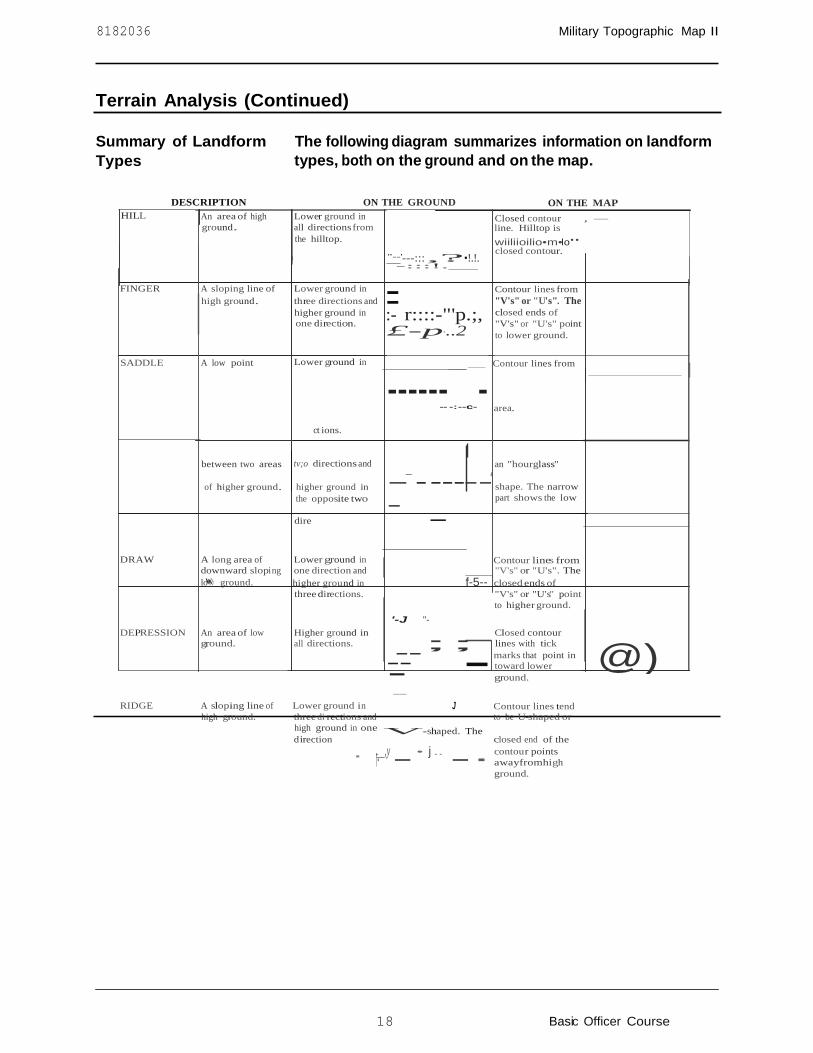
Summary of Landform Types
The following diagram summarizes information on landform types, both on the ground and on the map.
DESCRIPTION ON THE GROUND ON THE MAP HILL An area of high Lower ground in Closed contour , -
ground. all directions from line. Hilltop is the hilltop. wiiliioilio•m•lo"
closed contour. "--'---::: ,?•!.!. -:::!.
FINGER A sloping line of Lower ground in Contour lines from
high ground. three directions and "V's" or "U's". The higher ground in :- r::::-"'p.;,
one direction. £-p-..2
closed ends of "V's" or "U's" point to lower ground.
SADDLE A low point Lower ground in Contour lines from
ct ions.
-------- -: --c-- area.
between two areas tv;o directions and an "hourglass"
of higher ground. higher ground in the opposite two
-- - -----4
- shape. The narrow part shows the low
dire
DRAW A long area of Lower ground in Contour lines from downward slopi ng one direction and "V's" or "U's". The lowww ground. higher ground in f-5-- closed ends of
three directions. "V's" or "U's" point to higher ground.
DEPRESSION An area of low Higher ground in
ground. all directions.
'-J "-
--;;
Closed contour lines with tick
-- -marks that point in toward lower ground.
- RIDGE A sloping line of Lower ground i n J Contour lines tend
high ground. three di rections and to be U-shaped or high ground in one V-shaped. The d irection closed end of the
. r·. ,y - • j .. -· contour points awayfromhigh ground.

19 Basic Officer Course
B182036 Military Topographic Map II
Requirement 2 Review Questions
Requirement 2 map: Margarita Peak, California, 1:50,000, Sheet 2550 IV, Series V795, Edition 9-NGA.
1. Id entify the following landforms: a. 63818564 Answer: b. 63170165 Answer: c. 67430290-66720277 Answer: d. 72269420-72169457 Answer: e. 73010372 Answer: f. 72958753 Answer:
2. Determine the elevation of the following points: a. 69479485 Answer: b. 66379515 Answer: c. Road intersection in GS 6492 Answer: d. 67648890 Answer: e. 62469745 Answer:
For 3 and 4. Draw a straight line from coordinate (1) to coordinate (2) and provide the following information:
a. List all landforms starting with the landform at the first coordinate.
b. Give the ground distance, along the line, from each landform to the next to
the nearest 20m.
3. From (1) 73119587 to (2) 72599514. Item Landform Distance to Next Landform
a. b. c. d.
4. From (1) 67148260 to (2) 67998322.
Item Landform Distance to Next Landform a. b. c. d. e.
20 Basic Officer Course
B182036 Military Topographic Map II
Requirement 2 Review Questions (Continued)
5. Identify the following landforms:
a. 73419675 Answer: b. 68109579 to 68099600 Answer: c. 74890395 to 74650433 Answer: d. 69658010 Answer:
6. Determine the elevation of the following points:
a. 63408845 Answer: b. 59549830 Answer: c. 60400094 Answer: d. 65340195 Answer: e. 57578305 Answer:
7. Determine the kind of slope between the following points: a. 54448881 to 54298909 Answer: b. 56680423 to 56250435 Answer: c. 59500252 to 60160231 Answer: d. 60179304 to 60369355 Answer: e. 69029441 to 69349467 Answer: f. 62690160 to 63140185 Answer: g. 65849863 to 65999928 Answer: h. 72548282 to 73168322 Answer:
21 Basic Officer Course
B182036 Military Topographic Map II
Requirement 3 Review Questions
Requirement 4 map: Virginia, 1:50,000, Quantico MIM LND NAV SPECIAL, Edition 2- NIMA.
1. Identify the following landforms:
a. 92407430 Answer: b. 02107212 Answer: c. 03167434 Answer: d. 86346980 Answer: e. 90207262 to 90357295 Answer: f. 90457235 to 90607255 Answer: g. 92306820 to 92306850 Answer: h. 94206118 Answer: i. 79036322 Answer: j. 90596850 to 90656835 Answer:
2. Determine the elevation of the following points:
a. 94257245 Answer: b. 87407682 Answer: c. 91847630 Answer: d. 94306223 Answer: e. 95407065 Answer: f. 99387030 Answer:
For 3 and 4. Draw a straight line from coordinate (1) to coordinate (2) and identify the following along each line:
a. Name all features. Give a directional axis of all linear landforms.
b. Give the ground distance, along the line, from each landform to the next
landform to the nearest 20m. (Use the paper strip method) 3. From (1) 91507350 to (2) 91787320.
Item Landform Axis Distance to Next Landform a. b. c. d.
22 Basic Officer Course
B182036 Military Topographic Map II
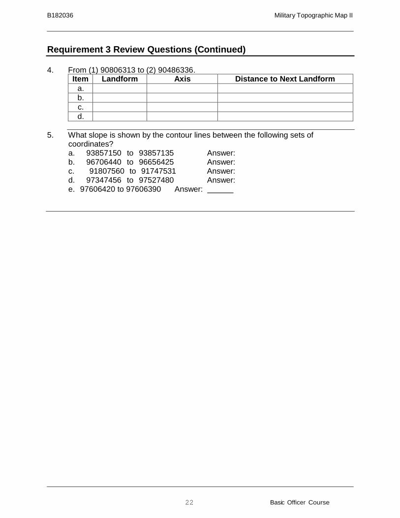
Requirement 3 Review Questions (Continued)
4. From (1) 90806313 to (2) 90486336.
Item Landform Axis Distance to Next Landform a. b. c. d.
5. What slope is shown by the contour lines between the following sets of
coordinates? a. 93857150 to 93857135 Answer: b. 96706440 to 96656425 Answer: c. 91807560 to 91747531 Answer: d. 97347456 to 97527480 Answer: e. 97606420 to 97606390 Answer:
23 Basic Officer Course
B182036 Military Topographic Map II
Item Landform Distance to Next Landform a. Finger 200m ± 20m b. Draw 350m ± 20m c. Finger 300m ± 20m
Item Landform Distance to Next Landform
a. Hill 250m ± 20m b. Finger 350m ± 20m c. Draw 450m ± 20m
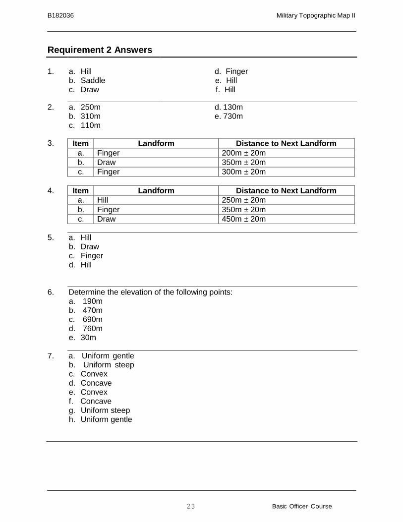
Requirement 2 Answers
1.
a. b. c.
Hill Saddle Draw
d. Finger e. Hill f. Hill
2. a. b. c.
250m 310m 110m
d. 130m e. 730m
3.
4.
5. a. Hill b. Draw c. Finger d. Hill
6. Determine the elevation of the following points: a. 190m b. 470m c. 690m d. 760m e. 30m
7. a. Uniform gentle
b. Uniform steep c. Convex d. Concave e. Convex f. Concave g. Uniform steep h. Uniform gentle
24 Basic Officer Course
B182036 Military Topographic Map II
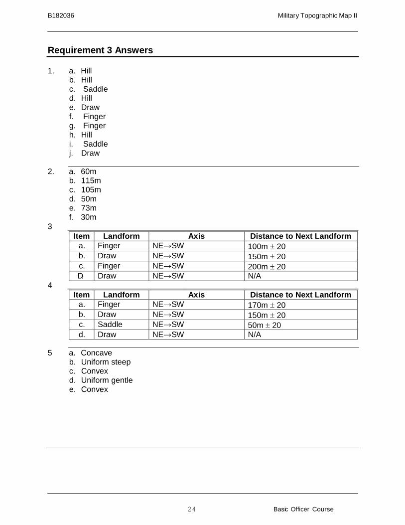
Requirement 3 Answers
1. a. Hill
b. Hill c. Saddle d. Hill e. Draw f. Finger g. Finger h. Hill i. Saddle j. Draw
2. a. 60m
b. 115m c. 105m d. 50m e. 73m f. 30m
3
Item Landform Axis Distance to Next Landform a. Finger NE→SW 100m ± 20 b. Draw NE→SW 150m ± 20 c. Finger NE→SW 200m ± 20 D. Draw NE→SW N/A
4
Item Landform Axis Distance to Next Landform a. Finger NE→SW 170m ± 20 b. Draw NE→SW 150m ± 20 c. Saddle NE→SW 50m ± 20 d. Draw NE→SW N/A
5 a. Concave
b. Uniform steep c. Convex d. Uniform gentle e. Convex
25 Basic Officer Course
B182036 Military Topographic Map II
Summary
In Military Topographic Map I, you were introduced to the map, protractor, and lensatic compass — the tools required for successful land navigation. This lesson has taught the ability to interpret many components of a map — water, terrain, and man-made features — and to “read the terrain.” The ability to correlate what one sees in the real world to what one sees on one’s map is crucial to becoming a successful navigator.
References
Reference Number or
Author Reference Title
FM 3-25.26 Map Reading and Land Navigation
Glossary of Terms and Acronyms
Term or Acronym Definition or Identification
Contour lines Lines on a map, set at a specified interval, which depict terrain elevation
m Meter(s) SOSES Shape, orientation, size, elevation, slope
Notes