meso-scale soil moisture validation sites on the eurasia continent
TRANSCRIPT
Meso-scale Soil Moisture Validation
Sites On the Eurasia Continent
Z. (Bob) Su ITC, University of Twente
The Netherlands
With contributions from J. Wen (CAREERICAS), Y. Ma (ITP/CAS), R. van der Velde, L. Dente, Z. Vekerdy, L. Wang, Y. Zeng, S. Lv, P.
Ferrazzoli (UR) [email protected]
www.itc.nl/wrs
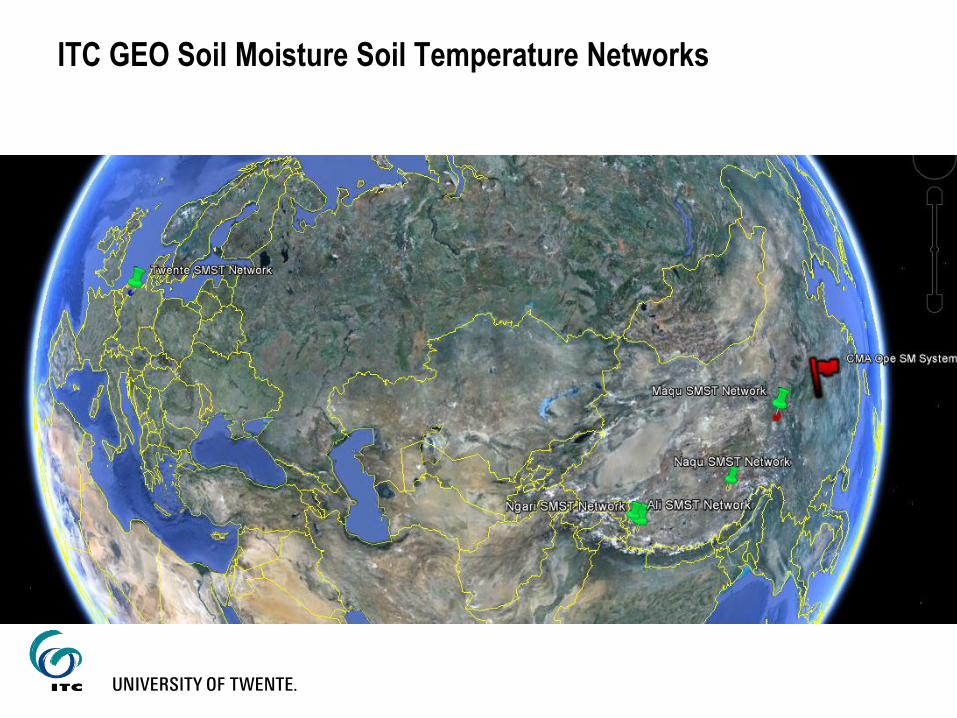
ITC GEO Soil Moisture Soil Temperature Networks
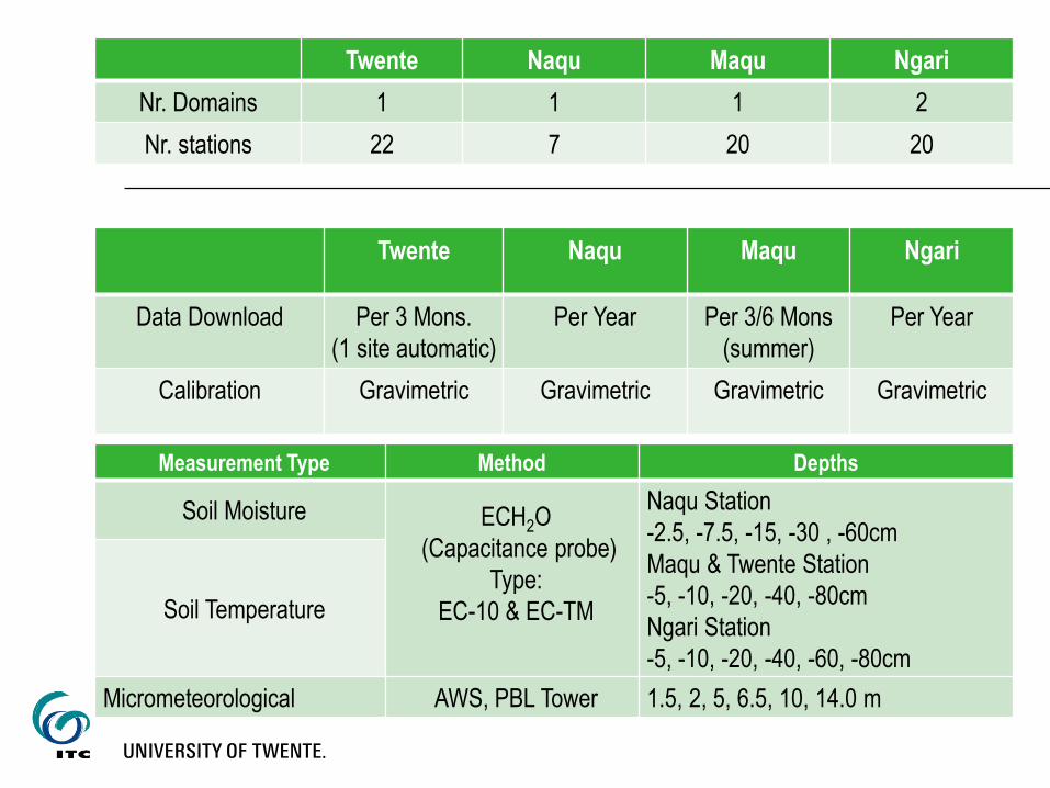
Twente Naqu Maqu Ngari
Nr. Domains 1 1 1 2
Nr. stations 22 7 20 20
Twente Naqu Maqu Ngari
Data Download Per 3 Mons.
(1 site automatic)
Per Year Per 3/6 Mons
(summer)
Per Year
Calibration Gravimetric Gravimetric Gravimetric Gravimetric
Measurement Type Method Depths
Soil Moisture ECH2O
(Capacitance probe)
Type:
EC-10 & EC-TM
Naqu Station
-2.5, -7.5, -15, -30 , -60cm
Maqu & Twente Station
-5, -10, -20, -40, -80cm
Ngari Station
-5, -10, -20, -40, -60, -80cm
Soil Temperature
Micrometeorological AWS, PBL Tower 1.5, 2, 5, 6.5, 10, 14.0 m
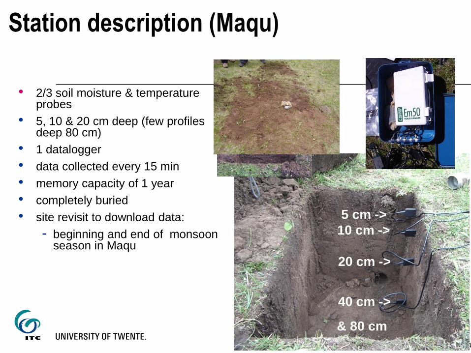
Station description (Maqu)
4
5 cm ->
10 cm ->
20 cm ->
40 cm ->
& 80 cm
• 2/3 soil moisture & temperature probes
• 5, 10 & 20 cm deep (few profiles deep 80 cm)
• 1 datalogger
• data collected every 15 min
• memory capacity of 1 year
• completely buried
• site revisit to download data:
- beginning and end of monsoon season in Maqu
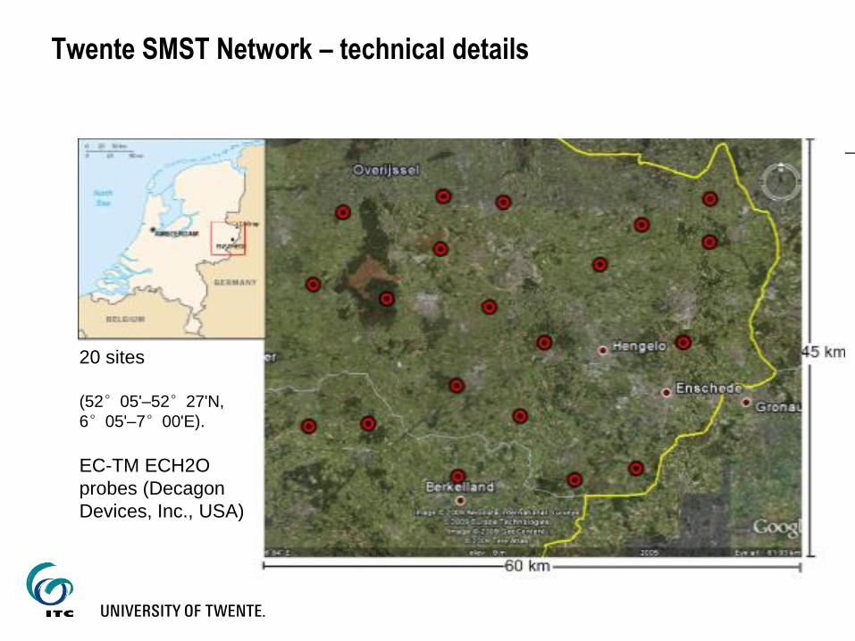
Twente SMST Network – technical details
Twente Site
20 sites
(52°05'–52°27'N,
6°05'–7°00'E).
EC-TM ECH2O
probes (Decagon
Devices, Inc., USA)
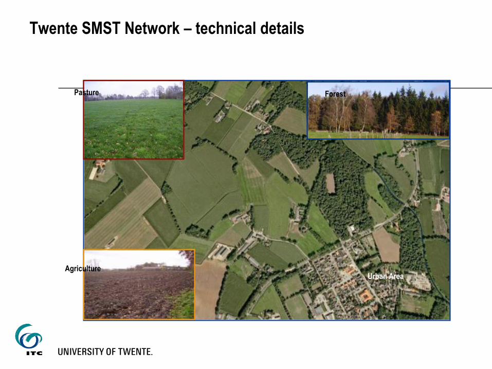
Agriculture
Pasture Forest
Urban Area
Twente SMST Network – technical details
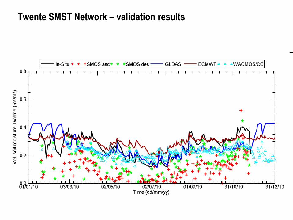
Twente SMST Network – validation results
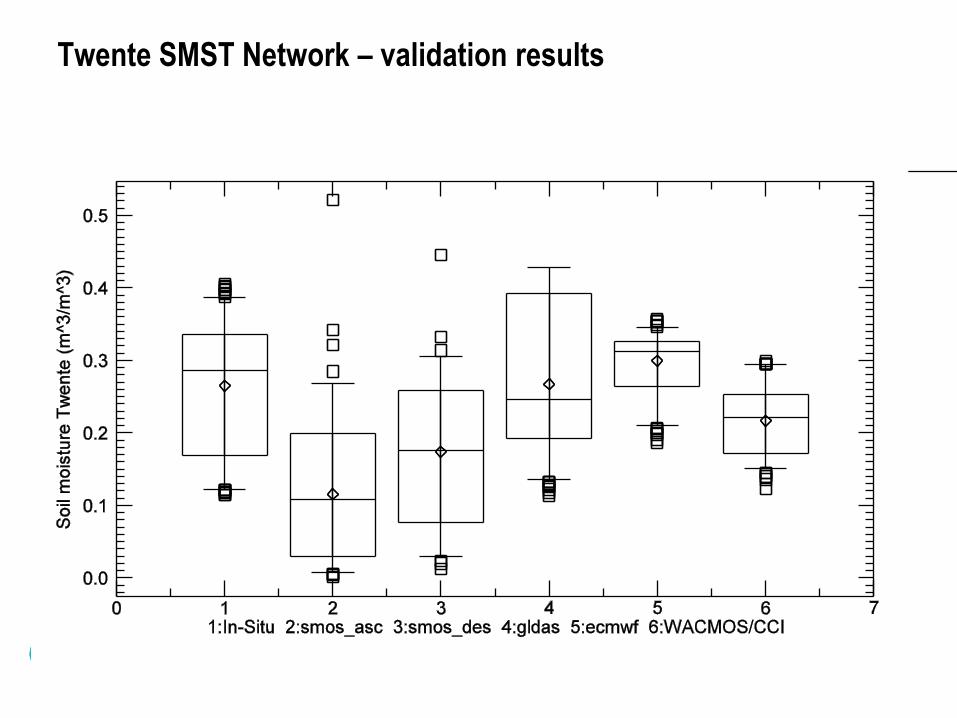
Twente SMST Network – validation results
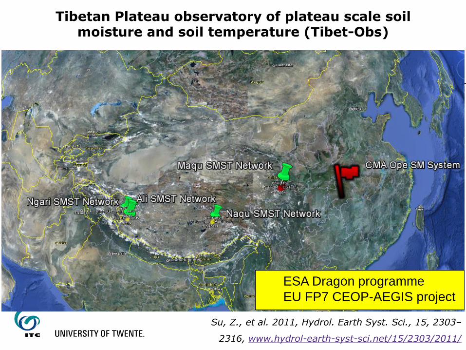
Tibetan Plateau observatory of plateau scale soil moisture and soil temperature (Tibet-Obs)
Su, Z., et al. 2011, Hydrol. Earth Syst. Sci., 15, 2303–
2316, www.hydrol-earth-syst-sci.net/15/2303/2011/
ESA Dragon programme
EU FP7 CEOP-AEGIS project
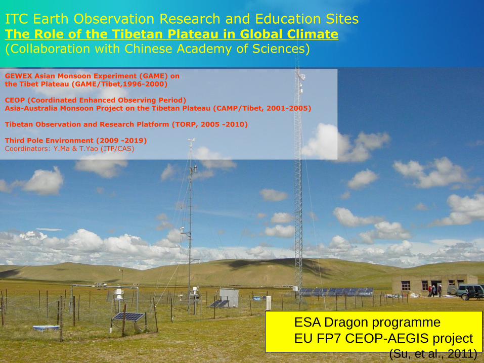
ITC Earth Observation Research and Education Sites
The Role of the Tibetan Plateau in Global Climate (Collaboration with Chinese Academy of Sciences)
GEWEX Asian Monsoon Experiment (GAME) on the Tibet Plateau (GAME/Tibet,1996-2000) CEOP (Coordinated Enhanced Observing Period) Asia-Australia Monsoon Project on the Tibetan Plateau (CAMP/Tibet, 2001-2005) Tibetan Observation and Research Platform (TORP, 2005 -2010) Third Pole Environment (2009 -2019) Coordinators: Y.Ma & T.Yao (ITP/CAS)
ESA Dragon programme
EU FP7 CEOP-AEGIS project (Su, et al., 2011)
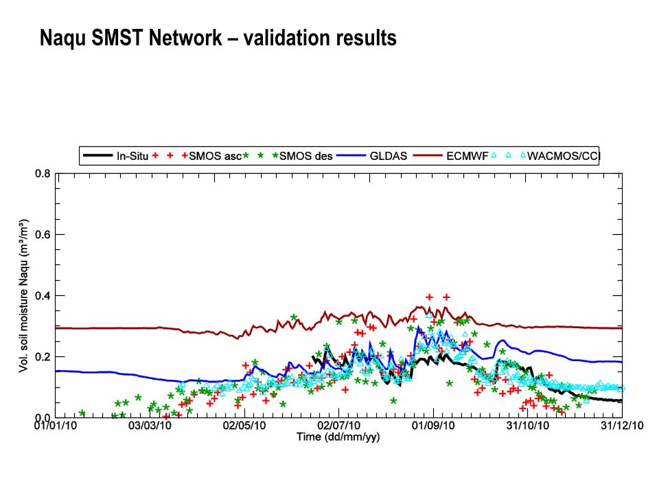
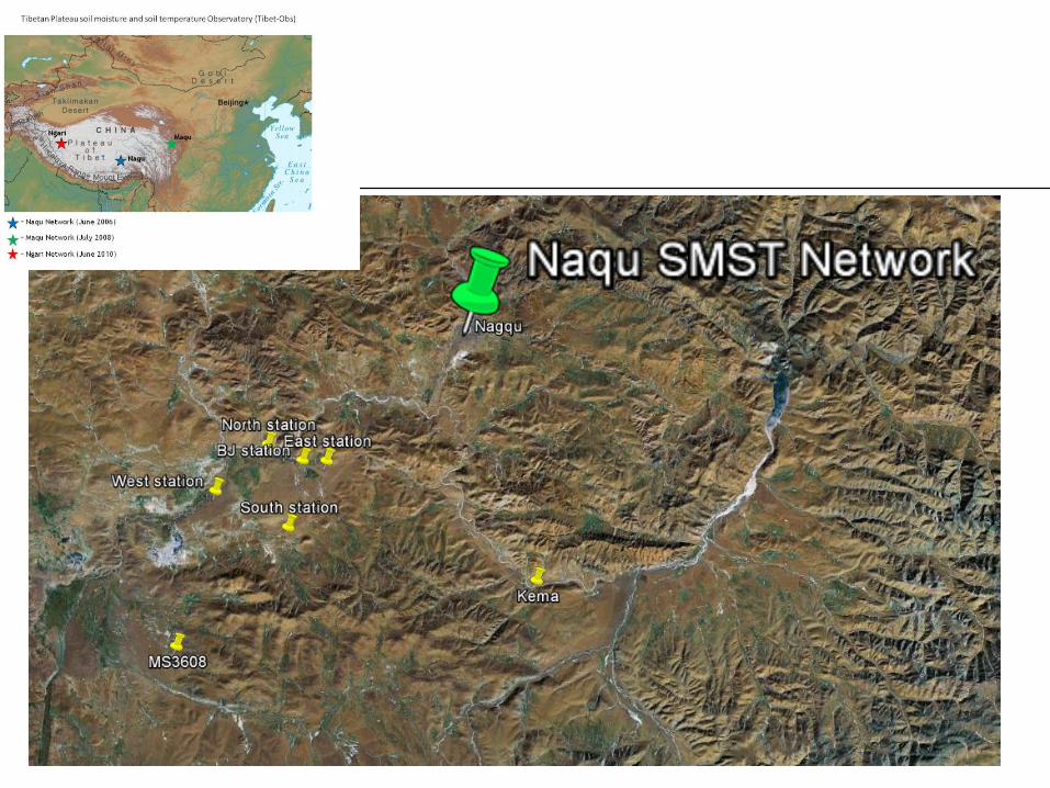
Naqu SMST Network – validation results
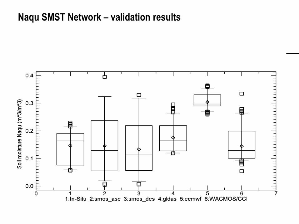
Naqu SMST Network – validation results
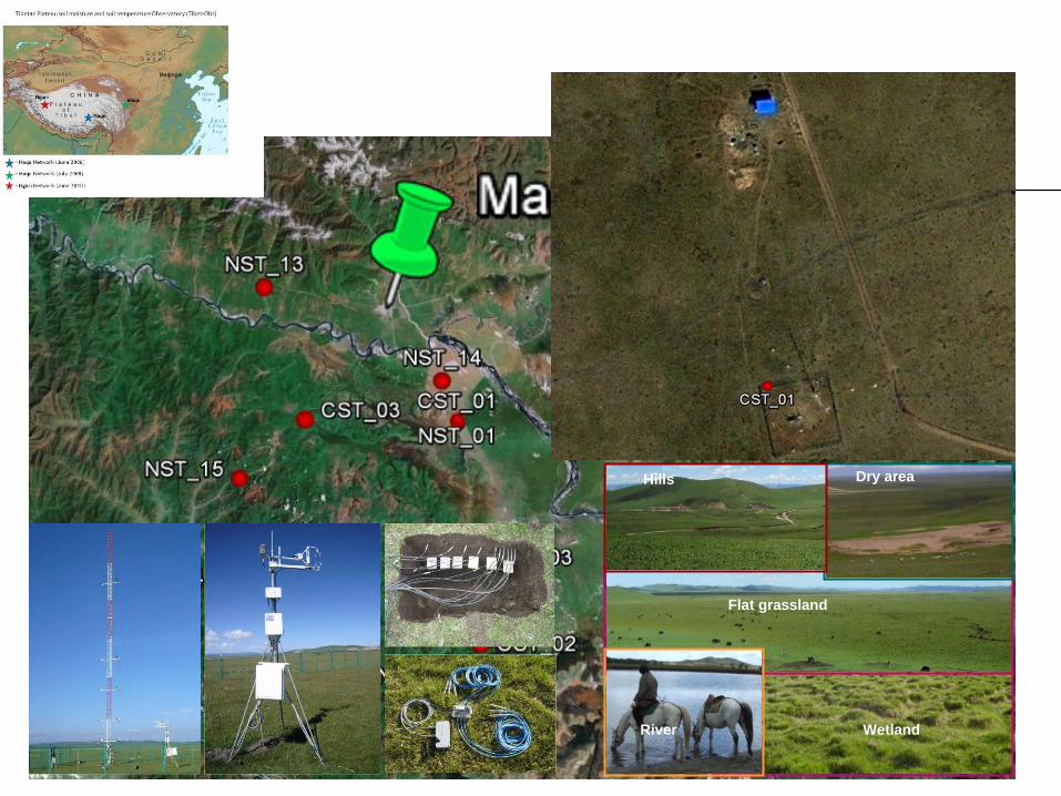
Hills
Flat grassland
River Wetland
Dry area
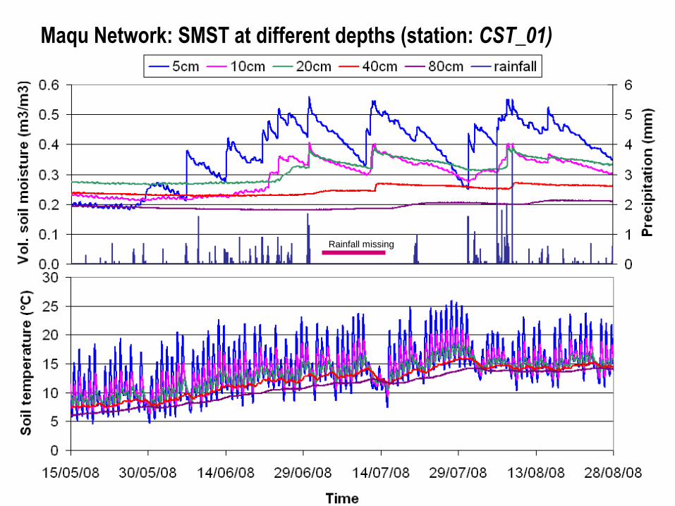
Maqu Network: SMST at different depths (station: CST_01)
Rainfall missing
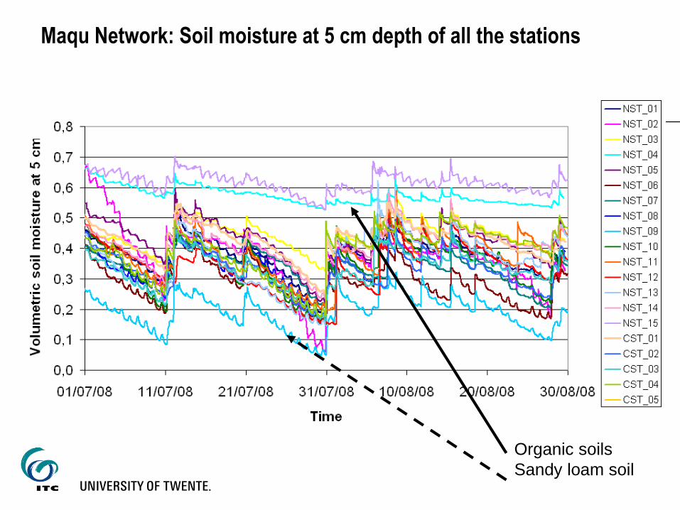
Maqu Network: Soil moisture at 5 cm depth of all the stations
Organic soils
Sandy loam soil
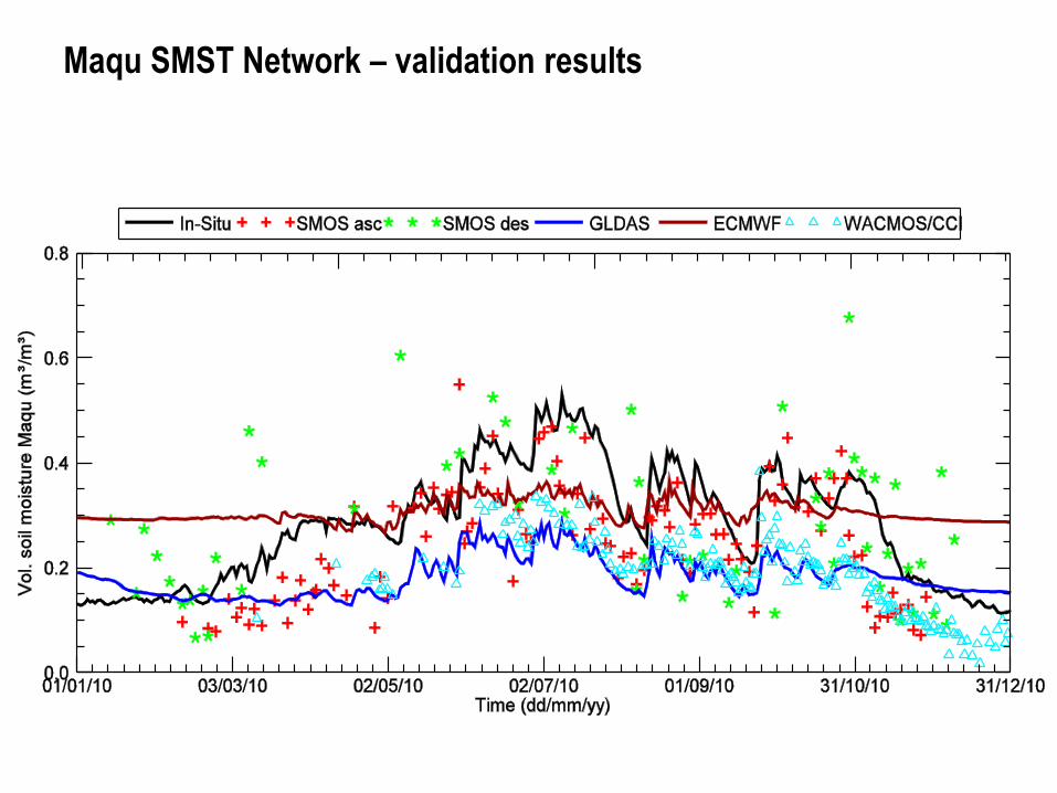
Maqu SMST Network – validation results
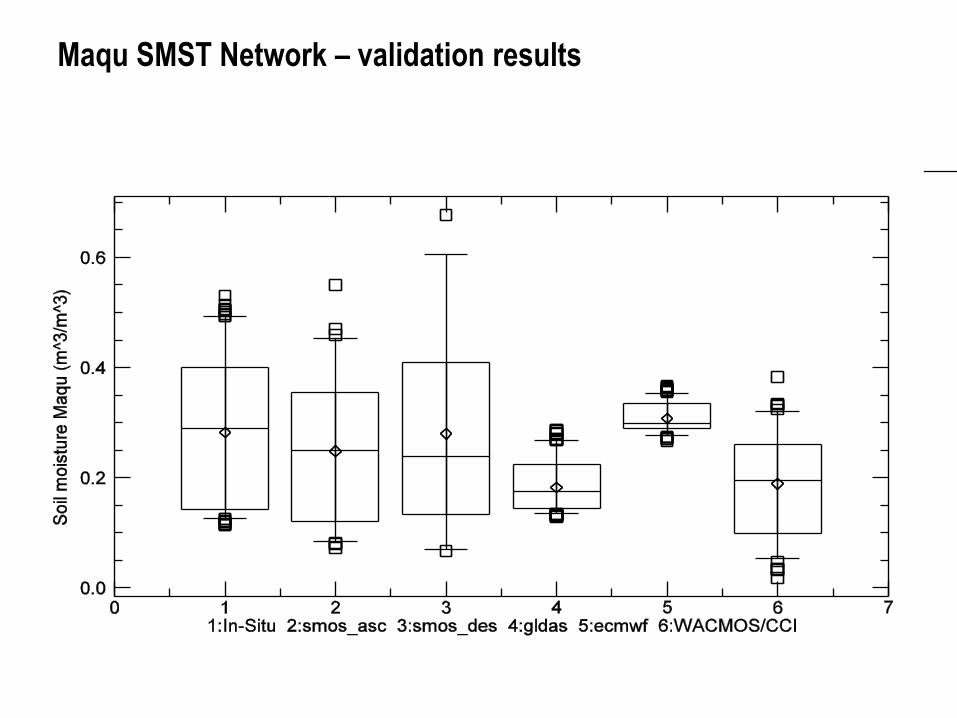
Maqu SMST Network – validation results
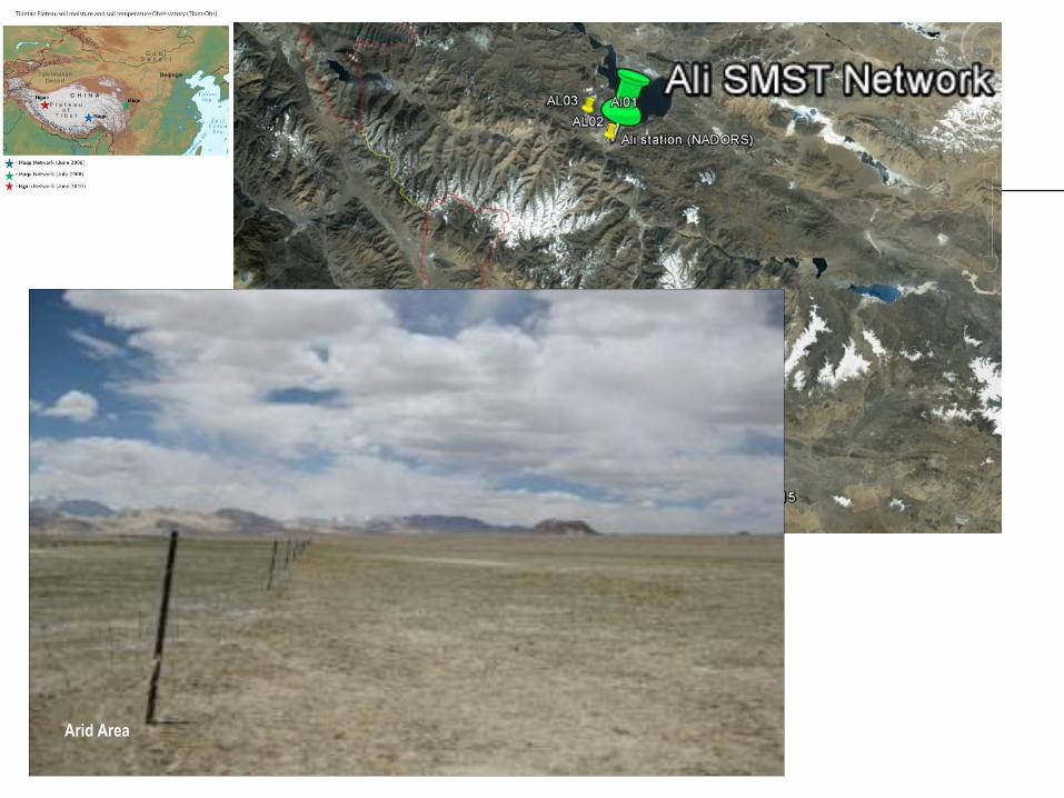
Arid Area
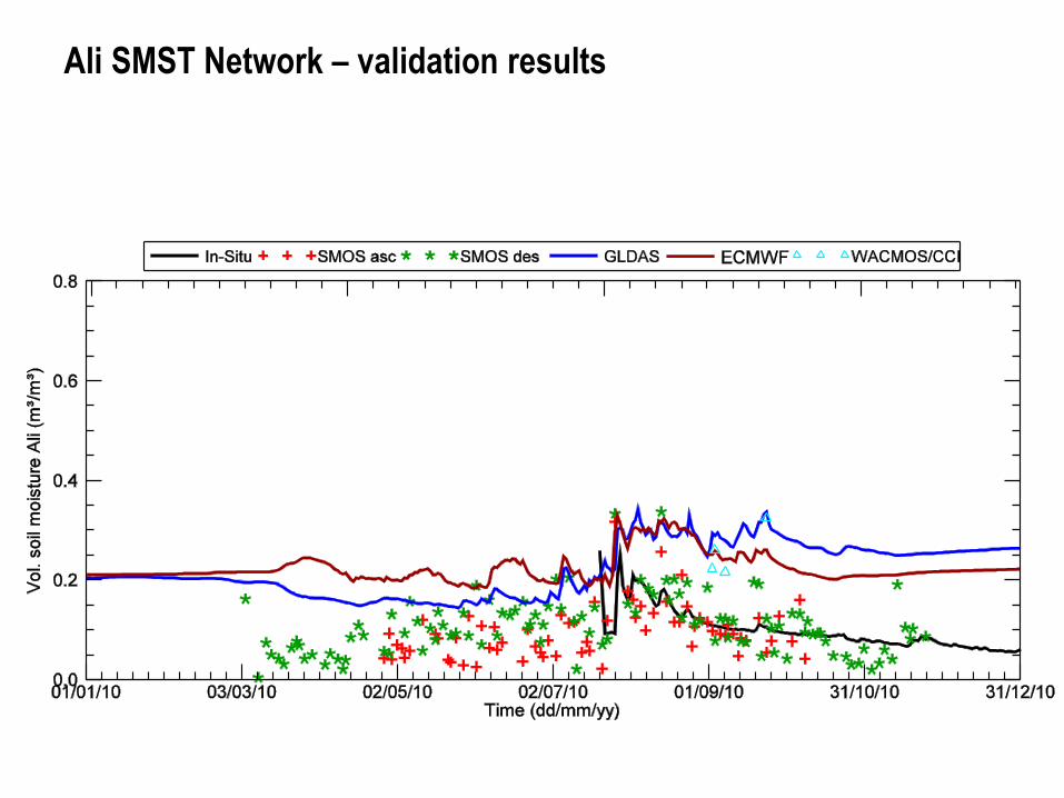
Ali SMST Network – validation results
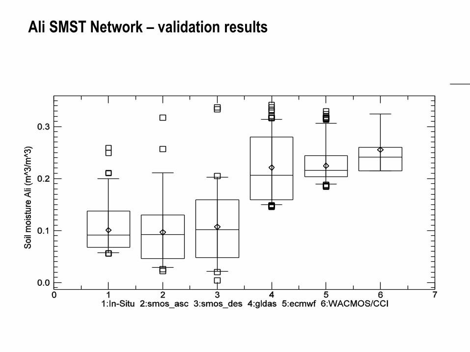
Ali SMST Network – validation results
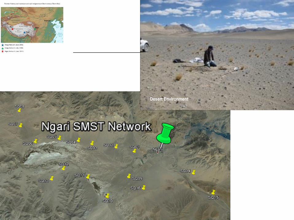
Desert Environment
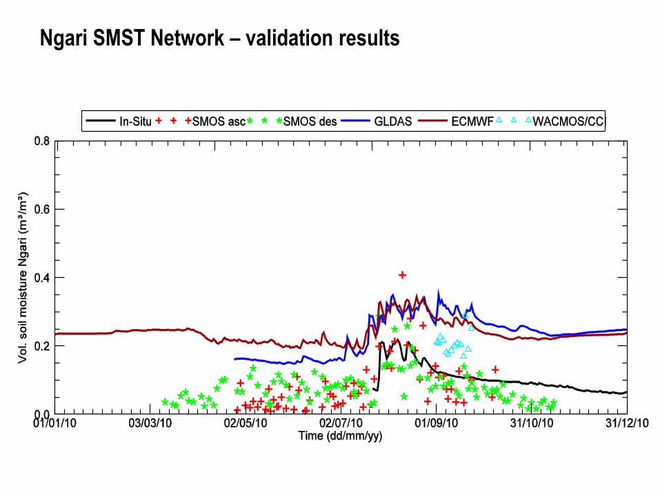
Ngari SMST Network – validation results
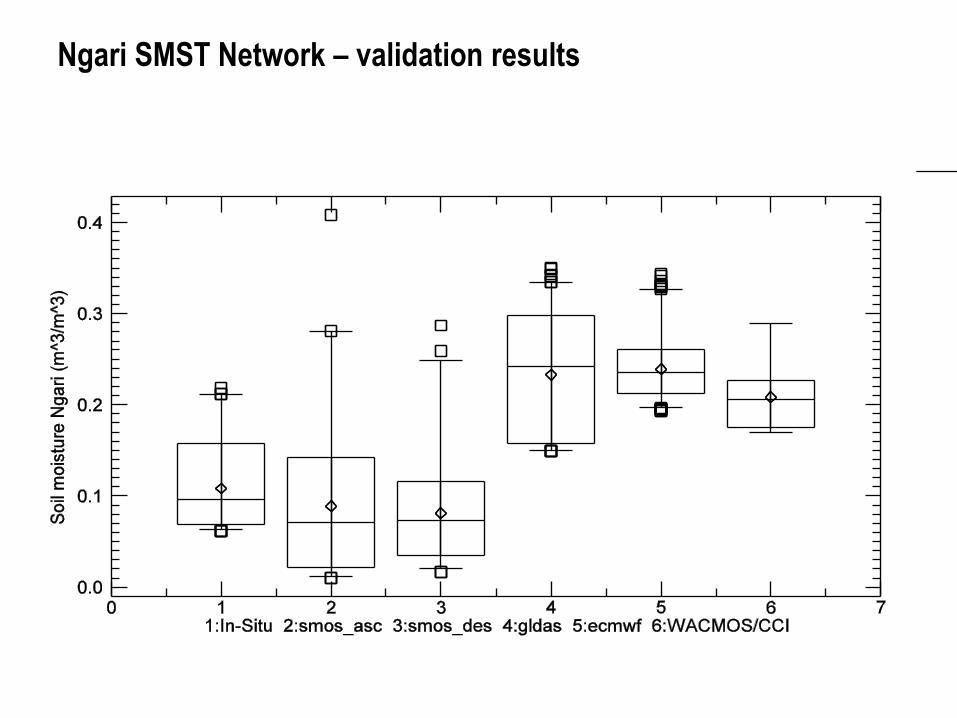
Ngari SMST Network – validation results

Some other research examples
Desert Environment
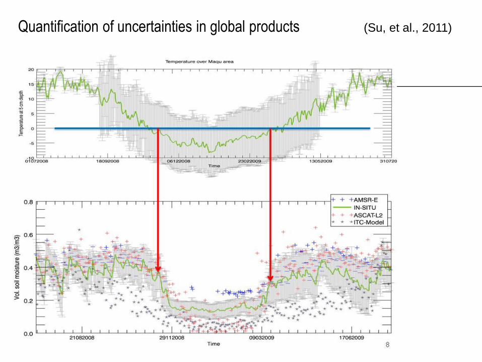
Quantification of uncertainties in global products
(Su, et al., 2011)
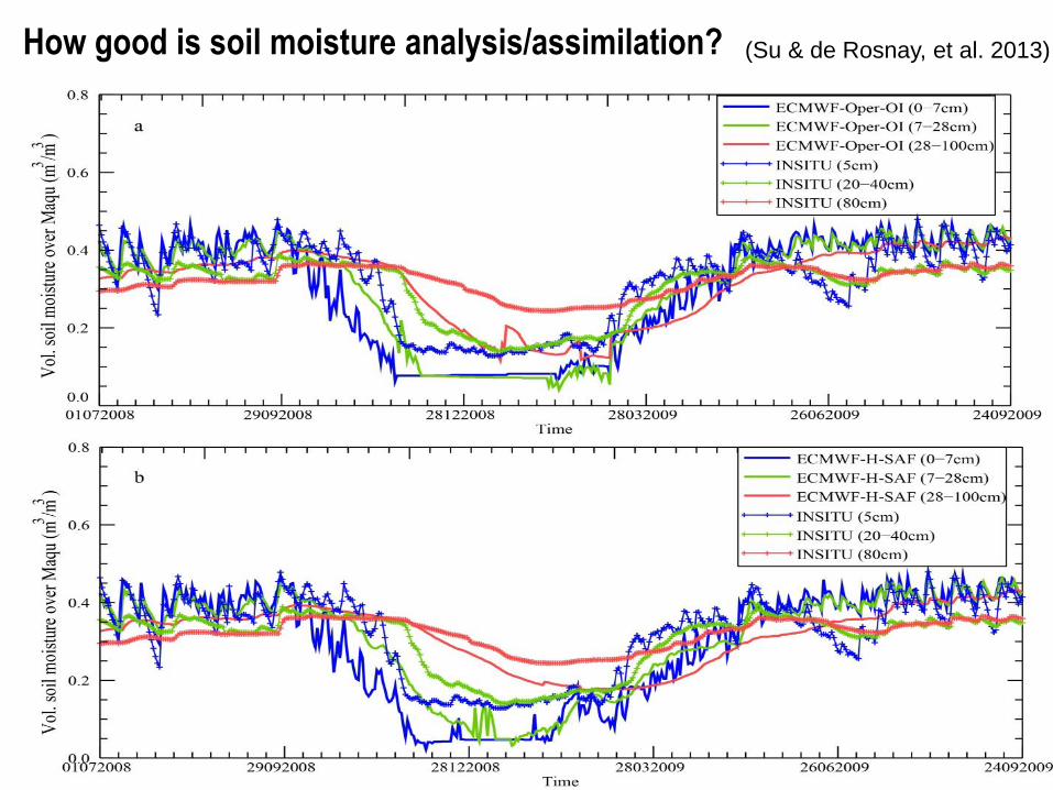
How good is soil moisture analysis/assimilation? (Su & de Rosnay, et al. 2013)
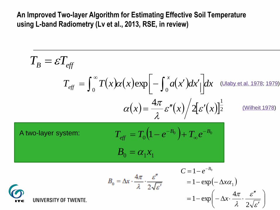
An Improved Two-layer Algorithm for Estimating Effective Soil Temperature
using L-band Radiometry (Lv et al., 2013, RSE, in review)
effB TT
dxxdxaxxTTx
eff
0 0exp
21
24
xxx
0010
BB
eff eTeTT
110 xB
A two-layer system:
2
4exp1
exp1
1
1
0
x
x
eCB
(Wilheit 1978)
(Ulaby et al. 1978; 1979)
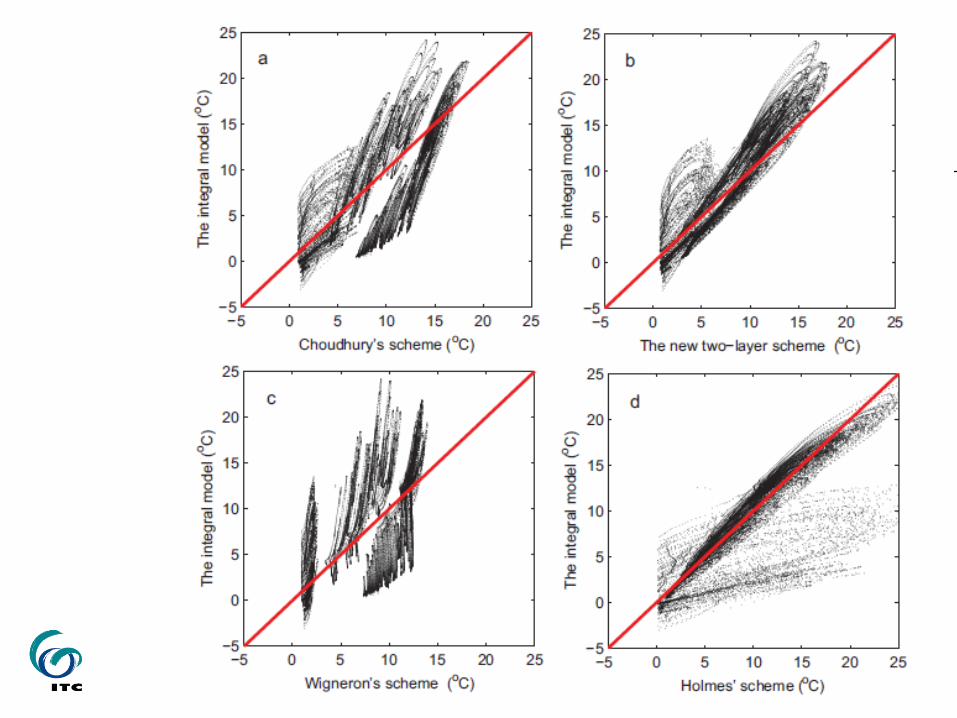
The weight function C is a parameter affected by wavelength (a), soil moisture
(b), sampling depth (c), and soil temperature (d)
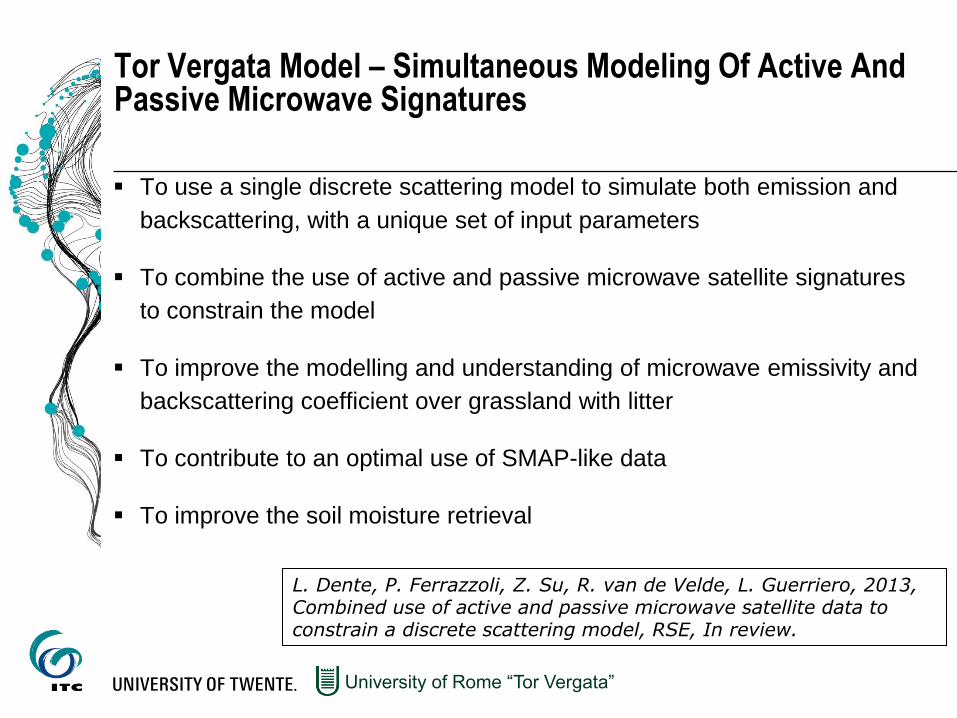
Tor Vergata Model – Simultaneous Modeling Of Active And Passive Microwave Signatures
To use a single discrete scattering model to simulate both emission and
backscattering, with a unique set of input parameters
To combine the use of active and passive microwave satellite signatures
to constrain the model
To improve the modelling and understanding of microwave emissivity and
backscattering coefficient over grassland with litter
To contribute to an optimal use of SMAP-like data
To improve the soil moisture retrieval
University of Rome “Tor Vergata”
L. Dente, P. Ferrazzoli, Z. Su, R. van de Velde, L. Guerriero, 2013, Combined use of active and passive microwave satellite data to constrain a discrete scattering model, RSE, In review.
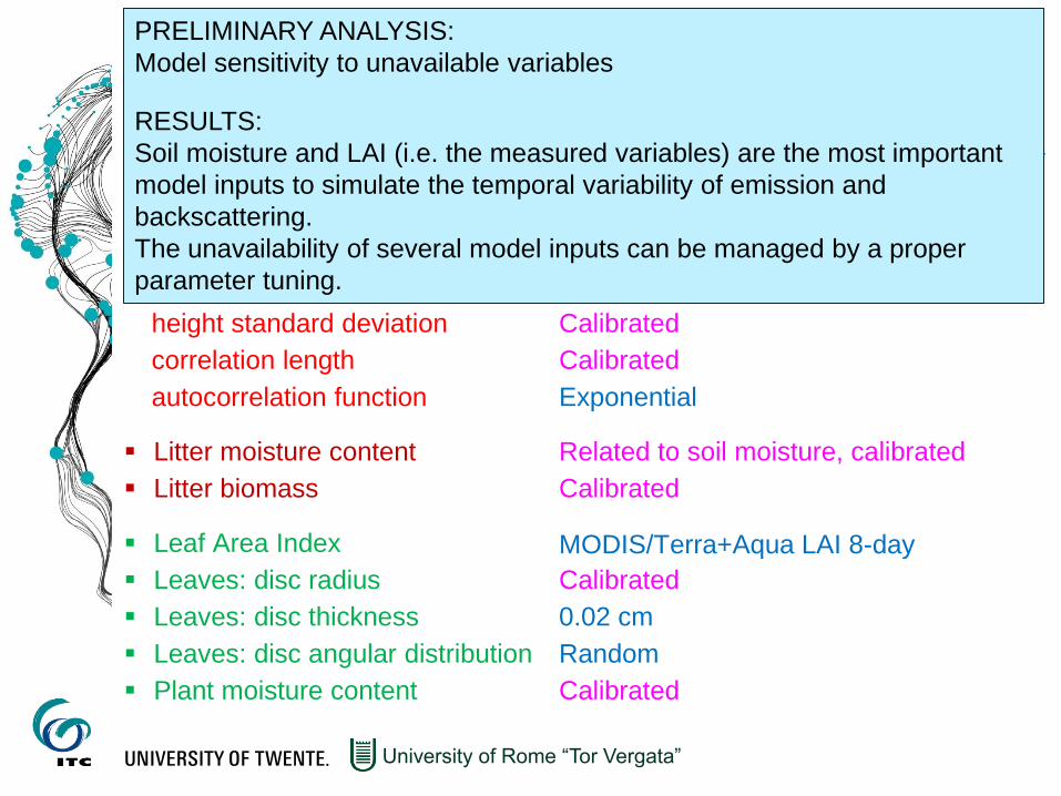
MODEL INPUTS
Incidence angle
Frequency
Volumetric soil moisture
Soil texture
Roughness:
height standard deviation
correlation length
autocorrelation function
Litter moisture content
Litter biomass
Leaf Area Index
Leaves: disc radius
Leaves: disc thickness
Leaves: disc angular distribution
Plant moisture content
University of Rome “Tor Vergata”
ASCAT and AMSR-E inc. angle
ASCAT and AMSR-E (C-band) frequency
Measured
Measured
MODIS/Terra+Aqua LAI 8-day
PRELIMINARY ANALYSIS:
Model sensitivity to unavailable variables
RESULTS:
Soil moisture and LAI (i.e. the measured variables) are the most important
model inputs to simulate the temporal variability of emission and
backscattering.
The unavailability of several model inputs can be managed by a proper
parameter tuning.
Calibrated
Calibrated
Exponential
Related to soil moisture, calibrated
Calibrated
Calibrated
0.02 cm
Random
Calibrated
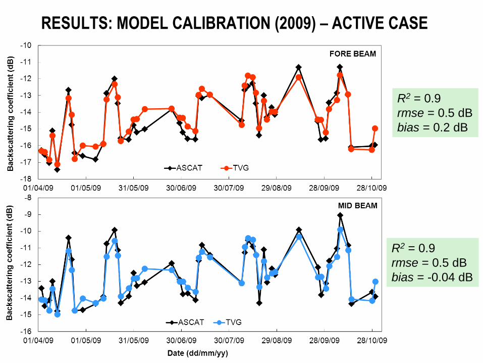
RESULTS: MODEL CALIBRATION (2009) – ACTIVE CASE
R2 = 0.9
rmse = 0.5 dB
bias = 0.2 dB
R2 = 0.9
rmse = 0.5 dB
bias = -0.04 dB
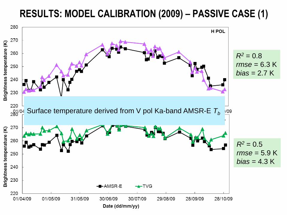
RESULTS: MODEL CALIBRATION (2009) – PASSIVE CASE (1)
R2 = 0.8
rmse = 6.3 K
bias = 2.7 K
R2 = 0.5
rmse = 5.9 K
bias = 4.3 K
Surface temperature derived from V pol Ka-band AMSR-E Tb
R2 = 0.8
rmse = 8.2 K
bias = 5.1 K
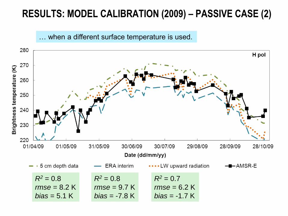
RESULTS: MODEL CALIBRATION (2009) – PASSIVE CASE (2)
R2 = 0.8
rmse = 9.7 K
bias = -7.8 K
R2 = 0.7
rmse = 6.2 K
bias = -1.7 K
… when a different surface temperature is used.
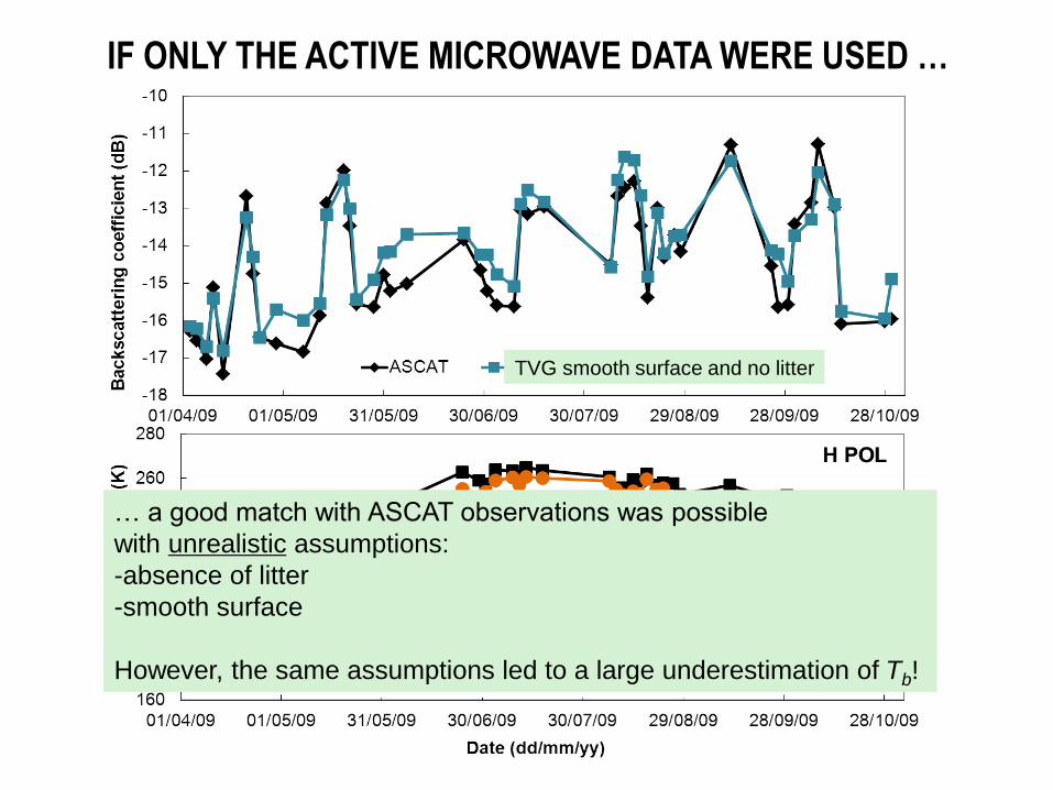
IF ONLY THE ACTIVE MICROWAVE DATA WERE USED …
TVG smooth surface and no litter
TVG smooth surface and no litter
… a good match with ASCAT observations was possible
with unrealistic assumptions:
-absence of litter
-smooth surface
However, the same assumptions led to a large underestimation of Tb!
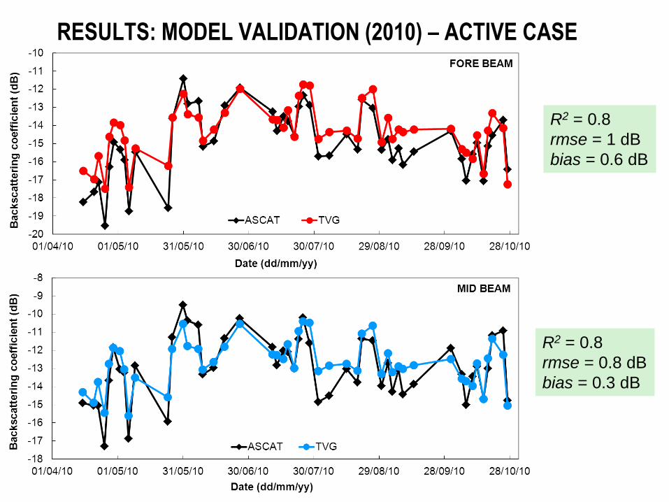
RESULTS: MODEL VALIDATION (2010) – ACTIVE CASE
R2 = 0.8
rmse = 1 dB
bias = 0.6 dB
R2 = 0.8
rmse = 0.8 dB
bias = 0.3 dB
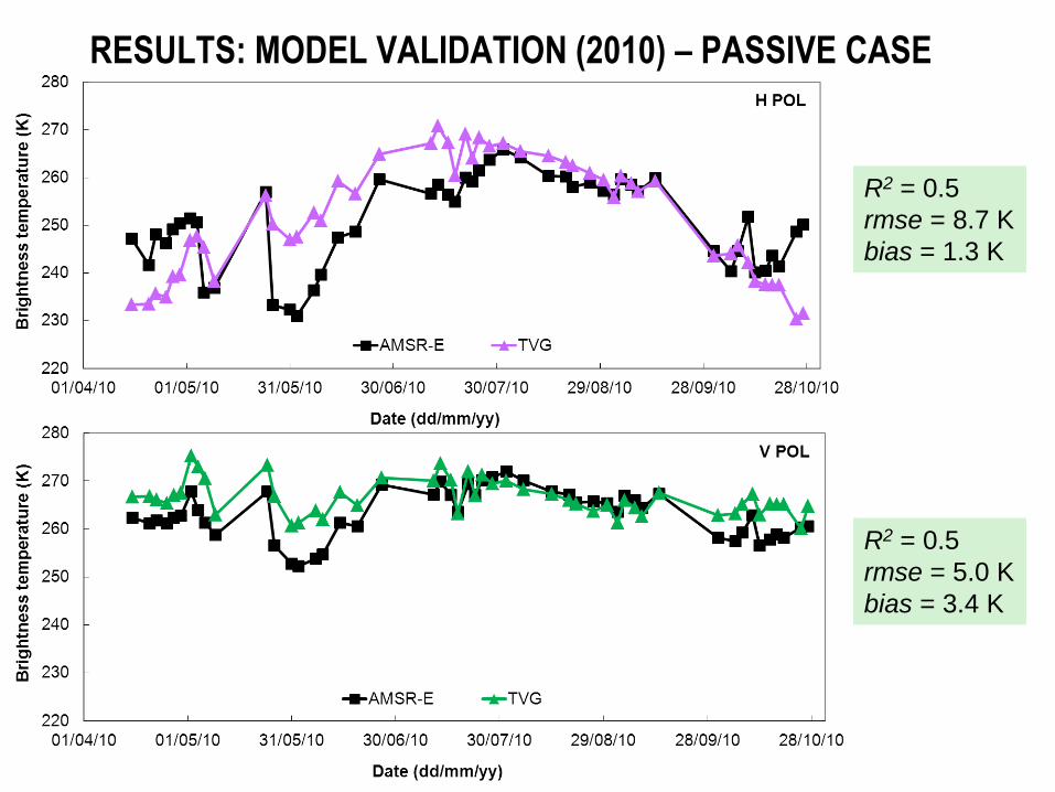
RESULTS: MODEL VALIDATION (2010) – PASSIVE CASE
R2 = 0.5
rmse = 8.7 K
bias = 1.3 K
R2 = 0.5
rmse = 5.0 K
bias = 3.4 K
Referances/Further Readings Su, Z., Wen, J., Dente, L., van der Velde, R., Wang, L., Ma, Y., Yang, K., and Hu, Z. 2011, The Tibetan Plateau
observatory of plateau scale soil moisture and soil temperature (Tibet-Obs) for quantifying uncertainties in coarse resolution satellite and model products, Hydrol. Earth Syst. Sci., 15, 2303–2316, 2011, www.hydrol-earth-syst-sci.net/15/2303/2011/, doi:10.5194/hess-15-2303-2011.
Dente, L., Vekerdy, Z., Wen, J. and Su, Z., 2012, Maqu network for validation of satellite - derived soil moisture products. Int. J. Applied Earth Observation and Geoinformation : JAG, 17 (2012) pp. 55-65.
Dente, L., Su, Z. and Wen, J., 2012, Validation of SMOS soil moisture products over the Maqu and Twente regions. Sensors, 12, 9965-9986.
Su, Z., P. de Rosnay, J. Wen, L. Wang, Y. Zeng, 2013, Ability of the ECMWF 1 model in simulating and analysis of root zone soil moisture on the Tibetan plateau , JGR (in revision)
van der Velde, R., Z. Su, and Y. Ma, 2008, Impact of soil moisture dynamics on ASAR signatures and its spatial variability observed over the Tibetan plateau. Sensors, 8(9),5479-5491.
van der Velde, R., Z. Su, 2009, Dynamics in land surface conditions on the Tibetan Plateau observed by ASAR, Hydrol. Sci. j., 54(6), 1079-1093.
van der Velde, R., Z. Su, M. Ek, M. Rodell, and Y. Ma, 2009, Influence of thermodynamic soil and vegetation parameterizations on the simulation of soil temperature states and surface fluxes by the Noah LSm over a Tibetan plateau site, Hydrology and Earth System Sciences, 13, 759-777.
van der Velde, R., Salama, M.S., van Helvoirt, M.D. and Su, Z. (2012) Decomposition of uncertainties between coarse MM5 - Noah - Simulated and fine ASAR - retrieved soil moisture over Central Tibet. J. hydrometeorol., 13 (6), 1925-1938.
van der Velde, R., Su, Z., van Oevelen, P., Wen, J., Ma, Y. and Salama, M.S. (2012) Soil moisture mapping over the central part of the Tibetan Plateau using a series of ASAR WS images. Remote sens. Environ., 120,175-187.
Dente, L., P. Ferrazzoli, Z. Su, R. van de Velde, L. Guerriero, 2013, Combined use of active and passive microwave satellite data to constrain a discrete scattering model, RSE, In review.
Lv, S., J. WEN, Y. Zeng, H.Tian, Z.Su, 2013, An Improved Two-layer Algorithm for Estimating Effective Soil Temperature in Microwave Radiometry using In Situ Temperature and Soil Moisture Measurements, RSE, in revision.