map of brooklin land use options - whitby€¦ · ca l rd. wes t montgomery avenue ... montgomery...
TRANSCRIPT


Winchester Road West
Winchester Road East
Bald
win
Stre
et
Ferguson Avenue
Ashburn Road
Hwy 407
Roybrook Avenue
SWP
Brooklin Major Central AreaLand Use Options - Option 1 August 19, 2015
VG
Heber D
own C
rescent
Vipond Road
Cassels Road East
Bagot Street
Pearl StreetPrincess Street
Durham
Street
George St.
Roebuck St.
Campbell St.
Way St.
Pric
e St
.
tseW .dR slessaC
Montgom
ery Avenue
Torian Avenue
Hebe
r Dow
n Cr
esce
nt
Mitchel Avenue
Garside Avenue
Church Street
Low Density Residential
Medium Density Residential
High Density Residential
Mixed Use - Mid Rise
Mixed Use - High Rise
Institutional
Major Commercial
Major Commercial Downtown Infill
Major Commercial DowntownRedevelopment
Prestige Industrial Business Park
Urban Square
Pedestrian Promenade
Village Green
Local Park
Storm Water Management Pond
Level 1 Natural Area
Level 2 Natural Area
Floodplain
Major Central Area Boundary
Proposed Street
VG
VG
VG
Chelm
sford Drive
PL
VG
SWP
LP
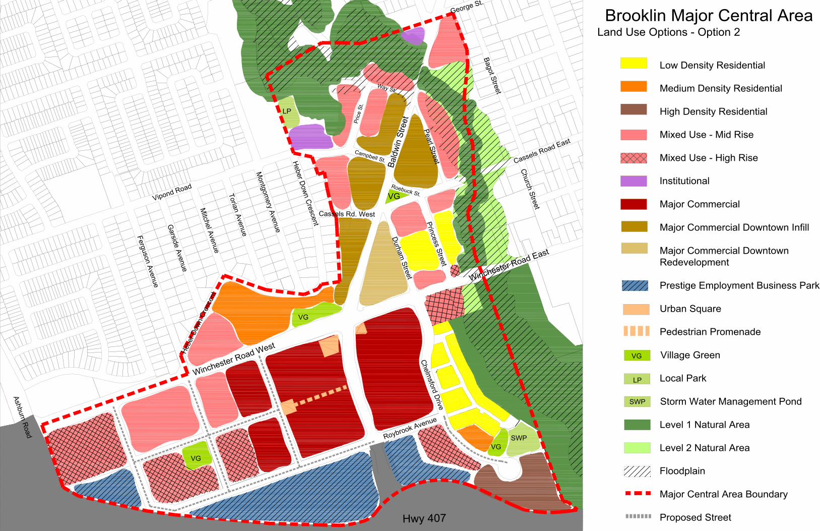
Brooklin Major Central AreaLand Use Options - Option 2 August 19, 2015
Low Density Residential
Medium Density Residential
High Density Residential
Mixed Use - Mid Rise
Mixed Use - High Rise
Institutional
Major Commercial
Major Commercial Downtown Infill
Major Commercial DowntownRedevelopment
Prestige Employment Business Park
Urban Square
Pedestrian Promenade
Village Green
Local Park
Storm Water Management Pond
Level 1 Natural Area
Level 2 Natural Area
Floodplain
Major Central Area Boundary
Proposed Street
Winchester Road West
Winchester Road East
Bald
win
Stre
et
Ferguson Avenue
Ashburn Road
Hwy 407
Roybrook Avenue
SWP
VG
Heber D
own C
rescent
Vipond Road
Cassels Road East
Bagot Street
Pearl StreetPrincess Street
Durham Street
George St.
Roebuck St.
Campbell St.
Way St.
Pric
e St
.
Cassels Rd. West
Montgom
ery Avenue
Torian Avenue
Hebe
r Dow
n Cr
esce
nt
Mitchel Avenue
Garside Avenue
Church Street
VG
VG
VG
Chelmsford Drive
VG
LP
LP
SWP
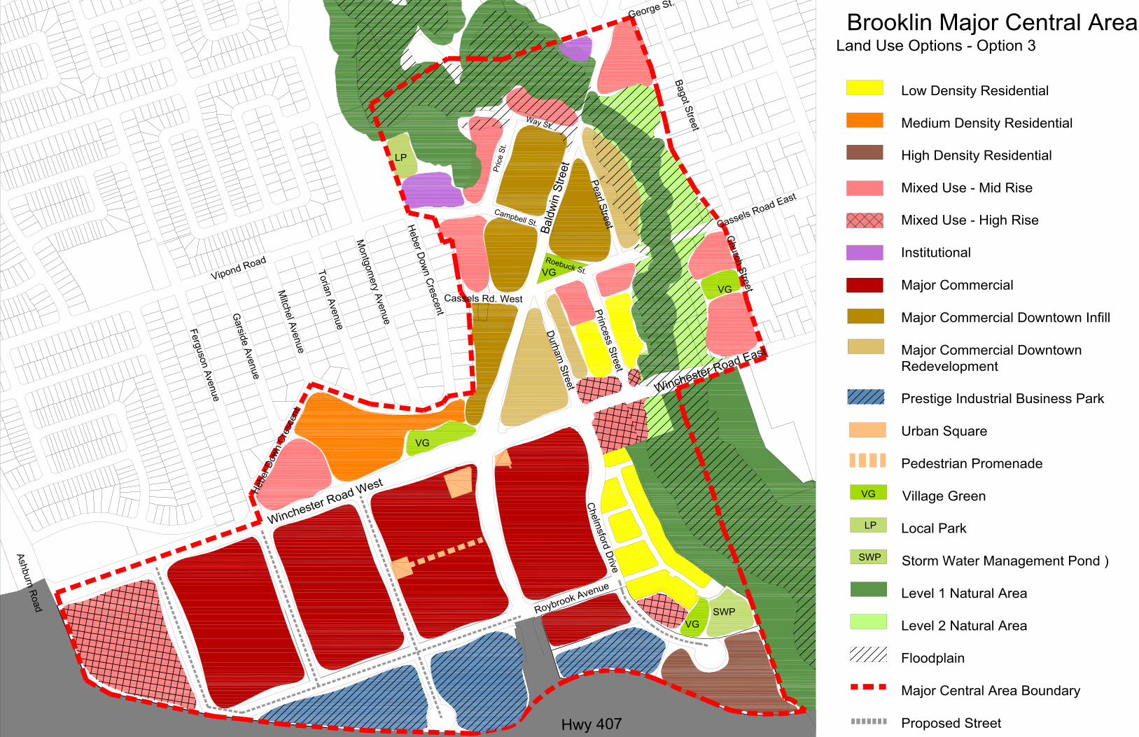
Brooklin Major Central AreaLand Use Options - Option 3 August 19, 2015
Low Density Residential
Medium Density Residential
High Density Residential
Mixed Use - Mid Rise
Mixed Use - High Rise
Institutional
Major Commercial
Major Commercial Downtown Infill
Major Commercial DowntownRedevelopment
Prestige Industrial Business Park
Urban Square
Pedestrian Promenade
Village Green
Local Park
Storm Water Management Pond )
Level 1 Natural Area
Level 2 Natural Area
Floodplain
Major Central Area Boundary
Proposed Street
Winchester Road West
Winchester Road East
Bald
win
Stre
et
Ferguson Avenue
Ashburn Road
Hwy 407
Roybrook Avenue
SWP
Heber D
own C
rescent
Vipond Road
Cassels Road East
Bagot Street
Pearl StreetPrincess Street
Durham Street
George St.
Roebuck St.
Campbell St.
Way St.
Pric
e St
.
Cassels Rd. West
Montgom
ery Avenue
Torian Avenue
Hebe
r Dow
n Cr
esce
nt
Mitchel Avenue
Garside Avenue
Church Street
VG
VG
Chelmsford Drive
VG
VG
LP
VG
SWP
LP