mammoth pacific geothermal development project: units … · idaafr, mammoth pacific geothermal...
TRANSCRIPT
IDAAFr
,
MAMMOTH PACIFIC GEOTHERMALDEVELOPMENT PROJECT: UNITS II AND IIIIEINV~ROIf\J)MEINTAl ~MPA(cT REPORTIEINV~ROINMEINT Al ASSESSMEINT
PREPARED FOR:
COUNTY OF MONOENERGY MANAGEMENT DEPARTMENT AND
BUREAU OF LAND MANAGEMENT
JULY 1987
ESAPLANNING AND ENVIRONMENTAL SERVICES
•
760 HAriMISON STREET
SAN FRANCISCO, CA. 94107
(415)896-5900
rMP II 80 III GEOTHERMAL
ENVIRONMENTAL IMPACT REPORT
TABLE OF CONTENTS
1.0 SUMMARY
1.1 Introduction1.2 Summary
1-1
1-11-2
2.0 INTRODUCTION, PROJECT OESCRIPTION, AND ALTERNATIVES 2-1
I
J
2.1 Summary Description of Project and Access2.2 Purpose of and Need for the Project2.3 Background to the EIR: Major Issues2.4 Regulatory Framework2.5 Proposed Project.
2.5.1 Production Well Field and Ga thering System2.5.1.1 Well j)~ilImgandTesting2.5.1.2 Wellhead and Downhole Facilities2.5.1.3 Gathermg System
2.5.2 Power Generation2.5.3 Electrical TraIlsmission Lines2.5.4 Injection Well FieldaIldDistribution Facilities
2:5.4.1 Well DrillillgandTestingDescription2.5.4.2 Injection Pumps and Gather!ngSystem
2.5.5 Abandonment2.5.6 Fire Safety
2.6 Altema tive2.6.1 Production Well Field and Gathering System2.6.2 Power Generation2.6.3 Electrical Transmission Lines2.6.4 Injection Well Field and Distribution Facilities2.6.5 Abandonment
. 2.6.6 Fire Safety2.7 No Action Alternative
3.0 AFFECTED ENVIRONMENT
3.1 Physical Environment3.1.1 Geology,Geologic Hazards, and Soils
3.1.1.1 Regional Geology .3.1.1.2 Geologic Hazards3.1.1.3 Soils and Erosion
3.1.2 Hydrology and Water Quality3.1.2.1 Models of the Geothermal Reservoir3.1.2.2 Surface Resources3.1.2.3 Subsurface Resources3.1.2.4 Summary of Hydrologic Da ta3.1.2.5 Information Needed to Evaluate the Models
3.1.3 Noise3.1.3.1 Regulatory Framework3.1.3.2 Noise Sources and Levels3.1.3.3 Noise-Sensitive Land Uses
2-12:"'12-3
.2-52-52-82-9
2-122-122-132-182-182-1B2-192-202-202-:222'-222-22
:- 2:-282-282-282-282-28
3-1
3-13-13-13-23-53-63-63-7
3-153-173-193-203-203-213-22
TABLE OF CONTENT'S (Continued)
3.1.4 Air Quality3.1.4.1 Existing Climate3.1.4.2 Existing Air Quality3.1.4.3 Regulatory Framework3.1.4.4 Sensitive Receptors
3.2 Biological Environment3.2.1 Regional Setting
3.2.1.1 Vegetation3.2.1.2 Terrestrial Wildlife
3.2.2 Local TerrestrialSetting3.2.2.1 Vegetation3.2.2.2 Terrestrial Wildlife
3.2.3 Speciallnterest Species3.2.4 Aquatic Environment
3.3 Social Environment3.3.1 Visual Resources
3.3.1.1 Existing Programs, Plans, and Policiesfor Managing Visual Resources
3.3.1.2 . Sensitive Receptors3.3.1. 3 Regional Setting3.3.1.4 Project Area
3.3.2 Socioeconomics3.3.2.1 General Socioeconomic Characteristics3.3.2.2 Land Use and Planning3.3.2.3 Economics3.3.2.4 County Fiscal Considerations3.3.2.5 Community Services
3.3.3 Recrea tional Resources3.3.4 Timber Resources3.3.5 Range Resources3.3.6 Cultural Resources3.3.7 Transportation and Access
4.0 IMPACTS AND MITIGATION
4.1 Proposed Project4.1.1 Physical Environment
4.1.1.1 Geology, Geologic Hazards, and Soils4.1.1.2 Water Quality and Hydrology4.1.1.3 ""Noise4.1.1.4 Air Quality
4.1.2 Biological Environment4.1.2.1 Vegeta tion4.1.2.2 Terrestrial Wildlife4.1.2.3 Aquatic Resources
4.1.3 Social Environment4.1.3.1 Visual Resources4.1.3.2 Socioeconomics4.1.3.3 Recreational Resources4.1.3.4 Timber Resources4.1.3.5 Range Resources
ii
Page
3-233-233-243-293-303-303-303-303-313-333-333-343-363-403-423-423-42
3-45 '-3-453-46
I3-473-473-473-503-533-553-59
.3-603-603-613-62
4-1
4-14-14-14-9
4-224-254-344-344-374-394-424-424-464-604-624-63

1 :
1 :
Il
]
1
J
IIJ
II
TABLE OF CONTENTS (Continued)
4.1.3.6 Cultural Resources4.1.3.7 Transportation and Access
4.2 Alterna tive Project4.2.1 Physical Environment
4.2.1.1 Geology, Geologic Hazards, and Soils4.2.1.2 Wa ter Quali ty and Hydrology and Noise4.2.1.3 Air Quali ty
4.2.2 Biological Environment4.2.2.1 Vegetation4.2.2.2 Terrestrial Wildlife and Aqua tic Resources
4.2.3 Social Environment4.2.3.1 Visual Resources4.2.3.2 Socioeconomics4.2.3.3 Recrea tional Resources4.2.3.4 Timber Resources4.2.3.5 Range Resources4.2.3.6 Cultural Resources4.2.3.7 Transporta tion and Access
4.3 No Project Alternative
5.0 OVERVIEW OF IMPACTS
5.1 Unavoidable Adverse Impacts5.1.1 Visual Resource5.1.2 Geothermal Resources and Recrea tion
5.2 Growth Inducing impacts5.3 Cumulative impacts
5.3.1 Physical Environment5.3.1.1 Geology, Geologic HazardS, and Soils5.3.1.2 Water Quality and Hydrology5.3.1.3 Noise5.3.1.4 Air Quali ty
5.3.2. Biological Environment5.3.2.1 Vegetation5.3.2.2 Terrestrial Wildlife5.3.2.3 AquatiC Environment
5.3.3. Social Environment5.3.3.1 Visual Resources5.3.3.2 Socioeconomics5.3.3:3· Recreational Resources5.3.3.4 Timber Resources5.3.3.5 Range Resources5.3.3.6 CuI tural Resources5.3.3.7 Transportation and Access
6.0 LIST OF AGENCIES AND PERSONS CONSULTED
6.1 Public Agencies6.2 Priva te Organiza tions
iii
Page
4-634-664-674-674-674-684-684-694-694-704-704-704-704-704-704-714-714-724-72
5-1
5-15-15-15-25-25-55-5
.< 5-55-95-9
5-105-115-115-125-125-125-145-155-155-155-155-16
6-1
6-16-2
TABLE OF CONTENTS (Continued)
7.0 REPORT CONTRIBlITORS
8.0 REFERENCES CITED
LIST·OF FIGURES
2-1 Project Area
2-2 Site Layout
2-3 Typical Drilling Pad and Equipmen t Layout
2-4 Typical Production Well Completion Drawing
2-5 Power Plant Plot Plan
2-6 Process Flow Diagram
2-7 Alternative Site Layout
2-8 Alternative Power Plant Plot Plan
2-9 Air-Cooled Ormat Energy Converter Unit
2-10 Brine Cascade Diagram
3-1a Geologic Map of Region
3-1b Geologic Cross Section Across Long Valley Caldera
3-1c Graph Showing Uplift Near Casa Diablo
3-2 Surface Drainage Features of the Mammoth Basin
3-3 Location of Thermal Features and Wells in,Southwest Long Valley
3-4 Geologic Cross-Section Showing Selected Wells
3-5 Habitat Type Map
3-6 Visual Quality Objectives and Major Viewpoint near Casa Diablo
3-7 USFS Visual Management System
3-8 Land Management Areas and Land Use
4-1 Pressure Changes in Subsurface Reservoir Due to Operationsat MP I and MP 11 & ll1
4-2 Photomontage of Project in Existing Setting
iv
7-1
8-1
2-2
2-7
2-10
2-11
2-15
2-16
2-23
2-24
I2-26
2-27
3-3
3-3•
3-3
3-8
3-9
3-16
3-35
3-43
3-44
3-48
4-14
4-45

~lTABLE OF CONTENTS (Continued)
1
11 Page
5-1 Regional Map for Ctunulative Analyses 5-4-j!
5-2 Pressure Changes in Subsurface Reservoir for Ctunulative Case 5-8
I5-3 Photomontage of MP II & III and PLES I in Existing Setting 5-13
LIST OF TABLES
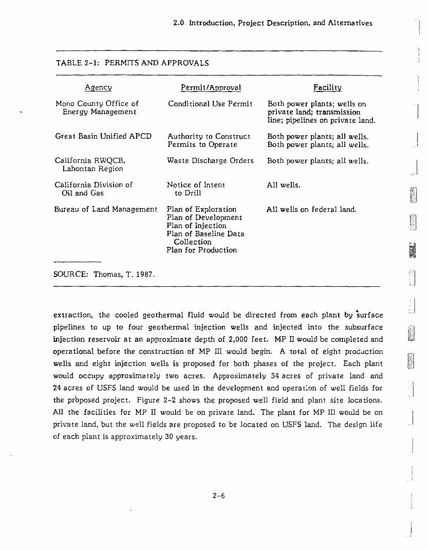
'] 2-1 Permits and Approvals 2-6
3-1 Long Valley Earthquakes of Magnitude 5.5 and Greater Since 1978 3-2
3-2 Soil Interpretations at Three Well Sites Proposed 3-5for MP II & III
3-3 Average Flowrate, Temperature, and Chemistry Data for 3-10Prominent Surface Hydrologic Features
3-4 24-Hour Noise Levels Near Casa Diablo Hot Springs 3-21
3-5 Diurnal Mixing Heights, by Season 3-25
I 3-6 Total Suspended Particulate Matter in the Mammoth 3-26Lakes Area 1981-1985
3-7 Carbon Monoxide Levels in the Mammoth Lakes Area, 1981-1985 3-27
3-8 Taxable Sales - Mono County 3-50
3-9 Employment in Mono County .' 3-51
3-10 Distribution of Mammoth Lakes' Labor Force by Employment Sector 3-52
3-11 General Revenues for Mono County (Fiscal Budget 1985-1986) 3-54
3-12 Approved Expenditures for Mono County (Fiscal Budget 1985-1986) 3-55
4-1 Modified Mercalli Scale 4-3
] 4-2 Approximate Acreage of Disturbed Soil on Private and USFS Land 4-6for Proposed Project
] 4-3 Proposed and Recommended Hydrologic Monitoring 4-19
4-4 Typical Construction Noise Levels at 50 Feet from 4-23
1Commercial/Industrial Construction Activities
4-5 PTPLU Modeling Parameters and Assigned Values 4-28
]
I v
I
TABLE OF CO!'ITE!'ITS (Continued)
LIST OF TABLES
Page
4-6 Estimated Maximum H2S Concentrations for Well Cleanout 4-29and Flow Testing
4-7 PTPLU Model Results for Continual Leakage of Isobutane 4-30
4-8 Maximum Ambient H2S Concentrations during a Well Blowout 4-31
4-9 Maximum Groundlevel H2S Concentrations after a Five-Minute 4-32Release of Geothermal Fluid at 5,000 gpm
4-10 Puff Model Input Parameters and Assigned Values 4-33
4-11 Puff Model Results for Catastrophic Release of Isobutane 4-34
4-12 Estimated Areas of Habitat Loss by Land Ownership 4-35
4-13 Local Employment 4-47
4-14 Popula tion Increases 4-48
4-15 Increased School Enrollment 4-53
4-16 Approxima te Acreage of Disturbed Soil on Private and 4-68USFS Land for Alternative
4-17 Estimated Acres of Habitat by Land Ownership for Alternative 4-69•
5-1 Projects Considered in the Cumulative Analyses 5-3
APPENDICES
1
I1
I
A.
B.
C.
Environmental Initial Study
Dri11ing Mud Additives Considered Non-Hazardous by theCalifornia Department of Heal th Services
Casa Diablo Geothermal Development Project: Deer MigrationStudy, Spring 1987 by Thomas Kucera
TECHNICAL APPENDIX
A-I
B-1
C-l
Hydrologic Study for the MP 11 and MP III Geothermal Project Joint EA/EIRprepared by Berkeley Group Inc., July 1987 is available in a separate volume fromMono County Energy Management Department.
vi
I]i
l]
I
I
I
Ij
I
1.0 Summary
1.0 SUMMARY
1.1 INTRODUCTION
Mammoth Pacific of Commerce, California,is proposing the construction and operation of
the Mammoth Pacific II & III (MP II & III) project consisting of two 12 megawa tt (MW)
(nominal) binary cycle geothermal electric generating plans in the southwest part of the
Long Valley in Mono County, California. The proposed power plants would be located on
private land, a 90-acre parcel on which the project applicants hold a lease interest in the
geothermal resource. The proposed well fields for MP II would be located on the same
private property. The well fields for MP III would be located on U.S. Forest Service land
located north of the plant site in lease CA-1l667A. The geothermal lease on this SO-acre
parcel of federal land is administered by the Bureau of Land Management (BLM).
In order to initiate this project, Mammoth Pacific has applied to the County of Mono for a
Conditional Use Permit (CUP) for the construction and operation of the generating plants,
the production and injection well fields, pipelines for transmission of the geothermal fluid,
and an electrical transmission line. Considera tion of this CUP requires a discre tionary
action by the Mono County Planning Commission, with the Mono County Board of.' .
Supervisors having the power to overrule their decision on appeal. The Initial Study by the
Mono County Energy Management Department indicated that the proposed project may
adversely affect the environment (see Appendix A). Part of the project would utilize
federal land. The BLM has determined that a full Environmental Impact Statement (EIS)
is not required, but that the major issues raised in the County's Initial Study must be
assessed to satisfy federal requirements for environmental review. Accordingly, this
Environmental Impact Report/Environmental Assessment (ElR/EA) has been prepared to
address the potential impacts of the project in accordance with the requirements of both
the California Environmental Quality Act (CEQA) and the National Environmental
Protection Act (NEPAl.
An ElR/EA is an informational document intended to provide decision-makers (in this
case, the County Planning Commission and Board of Supervisors and the BLM), other
1-1
1.0 Summary
responsible or interested agencies, and general public about the environmental effects of
a proposed project. The process of environmental review under CEQA and NEPA is
designed to enable public agencies to evaluate a project, determine its environmental
consequences, consider methods of avoiding or reducing adverse impacts, and evaluate
alternatives to the project. Both CEQA and NEPA restrict their definition of "significant ")
impact" to be an adverse environmental impact; economic and social considerations are
beyond their scope. However, responsible public agencies remain obligated to balance the
environmental effects against other public objectives, including social and economic ]
factors, in determining whether approval should be granted to a particular project.
The Mono County Energy Management Department and Planning Commission,
respectively, have the principal responsibility for carrying out the environmental review
process under CEQA and approving the CUP. The BLM is the federal lead agency under
NEPA. In addition, several other public agencies have been identified as having
jurisdiction or a review function over a portion or portions of the project. These agencies
include the U.S. Forest Service (USFS) and the U.S. Geological Survey (USGS); the State
of California Department of Fish and Game (CDFG), Office of Planning and Research, IDivision of Oil and Gas (CDOG), Regional Water Quality Control Board (RWQCB), Air
Resources Board (ARB), Energy Commission, Native American Heritage Commission, and
Office of Historic Preserva tion; the Great Basin Unified Air Pollution Control Board; the
Mono County Planning Department, Sheriff's Department, and Department of Public
Works; the Long Valley and Mammoth Lakes Fire Protection Districts; and the TgWD Of
Mammoth Lakes Planning Department.
1.2 SUMMARY
The EIR/EA addresses the anticipated envirorunental consequences of constructing and
operating two' 12 MW (nominal, equivalent to 10 MW net after parasitic power use at the
plant) power plants, their associated geothermal fluid production, handling, and injection
facilities, and the electrical transmission lines. The following surrunary describes the Jproject-related impacts by major subject area and the mitigating actions proposed to
reduce the extent of adverse impacts. This information is summarized for the
convenience of the reviewer and is not intended to supercede the more detailed analyses
in succeeding chapters of the document.
1-2J
I
~"------' ~ -'--' ~ -==_J
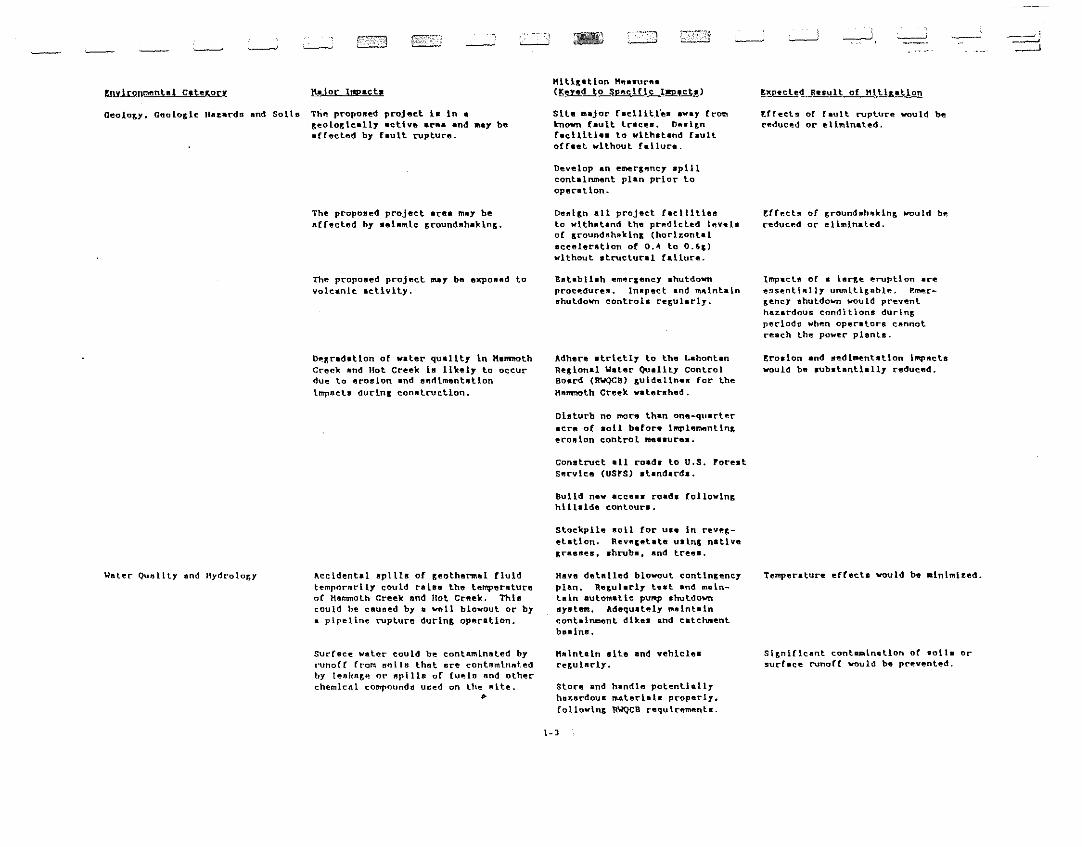
t~n~ntBl C.le&ory He tor It!jIJ.ch"iliKelion "~.lIur~.
(Keyed to sp~cific lapllcta) ~xp.cle~ R.sult of Hltl&ation
Gealoer, Gl:Iolo&lc nazards lind Solls The propolled projflct. 1. In ar.eotor.1c.l17 .etive '[S' .nd ~y be.rr~cted by fault rupture.
The proposed project .[ft. may beaefected by .elnmLc r.founduhaklnr..
The proponed project m.y bu expOllad tovoLc.nlc activity.
~Kr.d.tlon of water quality in MammothGreek lind Hot Creek la 1 t ke 11 to occurdue to ftt'oaton and lIe~lment.tlon
Impucta durinl conatructlon.
Slle Injor f_dlit.l'es ."ay £r01ll.known fault traces. D~.I~n
racilltlaa to withatand faultoffnl without failur;41.
Develop an e~rlencT IIpillcont.i~nt plan prior toopflration.
Dealln all projflct facllitlesto wlthlltand the predicted levelaoC &roundfthakinx (horizontalacceleration of O.~ to 0.6&)without atructural f.liure.
EBtabll.h emerlency shutdownprocedures. tnlpect and m~lnt.in
shutdown controls relularly.
Adhere strictly to the L-hontanRellonal Water Quality ControlBoard CRWQCB} luldellnall for theM.mmoth Creek waterllhed.
DI.turb no more than one-quarterecr" of 11011 be for. iMple~ntln&
"rollon control me••urflll.
Construct _II roada to u.s. ForeatService CUSrS) IItendard••
Build new accea. road. (ollowln&hlll.ide contoura.
stockpile 11011 for u•• in reve&etetion. Rev~l.t.t. ullinl nllllv"Irellaes, abruba, and lreeB.
tHecls of raull rupt.ure WQuld bereduced or eliminated.
~(fecta of &round"hftkin& would bereduced or eliminated.
Impacls of a larle eruption aree9St'ntl~lly unmltl&ftblt'. P.~r
&ency shutdown would preventhar.rdouc cond\tions durin&perlodn wh~n opere tors CBnnolreach the power; pienlll.
!r0810n and sedi-ent.llon Impactswould be aUbatantl.11y reduced.
W"l~T QunlilY lind lIydrolo&y Accident.l IIpl11s of r.eotharmal fluIdtempnrl!rtlY could ral•• the lumpur.tufeof Hammoth Creek and Hot Crsek. Thi.could be cftueed by • ~11 blowout or by« pipeline rupture durinr. operatIOn.
surface water could be contaminated bynmorr Crom 80118 that life contnmlnllt.edby tellkn&p. Of· npills of fuellJ end olherchemicill compounds used on lhe nlte .
•
Hav" detatled blowout contlnlencyplan. Relulllrly t •• t and maintain aulomatlc pu~ llhutdownuyatftm. Adequately maintaincontai~nt dikea and catchaenlbanln8.
Hftlnlain 8ite lind yehlc1eart'&uiarly.
Store and hBndle potentiallyhBrBrdoulI m.l"ri_1a prop.rly.Collowinc RWQCB requ\r~~nt •.
1- 3
Temperalure efrecta would be ain1mited.
st&nlflcant cont~ln.llon of 1I011s orsurf.ce runoff would be prevented.
EniliQnntent...a.LCJ.!~.r&I:.l 6o.i~
KttlClltlon HessuresLKey,d to Speclflc Impacts) ~~@cted Renult of Hlt\~lItlon
Wmlmr Qumllly and Hydrolo&y {conl.} lIave a detailed aplll continr.encypion whlch should include:1) 1mmediate removal or spilledfluld by pump trucks for properdispoftal;2) conntruction of containmentdikeD wlth heavy equipmenl;
3) removal of contaminated 8011s;4) l~diate cleanup; llnd5) notlflcation of appropriatepublic _,enciea.
If &eoth~rmal flul~ 1. d.llv~r~d to HotCre.k Hatchery, impact. at tb~ hatcherywould b~ ~limlnaled but would iner.ageAltKhlty ~l.~vh@re. 1( a well wereconstructed at Hot Cr~ak Cor&e, tostflow would be replaced, but aeenlcvalue and viAitor appeal a. It currentlyex1sts would not b~ restored. If theKP 11 , III powftr plant operatlons werereduced or abut down. flow Levela ofIIpr1n&s would nol be rwatoredimmediately. b@cause of the tl~
required [or the syst~ to recover.
Tluld monltor1n& ~y help dlatin&ul.h1mpacts due to ulI.tural eau~es (sucb astectonlc atra1n and BeaBonal preclp1tation .mounts) [rom impactfl attributable to power plant operat1ons.
If .prln& flow. or t"mperatureswere reduced at Hot Creek Halcher,or Hot Creek Gorle, due to KP 11 ,KP tl1 po~r plant operation••Mammoth Pacific could:1) supply hot water b, pumplnr.,eolhe~al ftutd and delivertnr.It to the hatchery;2} Bupply loat [lov or hot wsterto the bsthin& erea; and)) reduce or atop KP II , 111po~r plant operatlona.
eslablish a prolram of fluid monitortne (Bee Table ~-3). Hea.urechemistry. flow rate, and temperature of iMPorlant ~ur[ace
featurea; tr.mperature. pres.ure.flow rate. and chr.~i.tr7 of observation vells; injection ~ll pressure. snd production ~ll temperature,presaure, flow rate, and chemistry.
Imp"cls on nurface t1,,~nt\lIl featuresr""ultln& frolft production/injectionoperations at the Proponed project aredifficult to prediet. Experts studyln&the ~eoth~rmlll reservolr do not _,reeon how fluids move wlthln therftsp.rvoir. One model (Upvellin~/
fracture r10w) postulates that deepupwelllni from separate sources feedsmultIple reservolrs, ao that pumpln& litCass Dlablo would have no effeet on therelJp.rvolr{s} at Hot Creek. The secondmodel (Lateral 'low) proposea • sourceof &eothel~81 f1uld ln the Bouthweuternpart of the caldera, with fluldmovr.~nt toward the ellst. Caicu1atlonndone u81n& thlft ronde1 lndicate that,ualn& the information currentlyava11able about reservolrcharacteristiea, there would probabLybe no ~frect on reservoir preftsure ortemperature beneath Hot Creek; however,there ls the poss1bility that due tothe lack of lnformat1on about reuervo1rchlil"l"r.t.t~rtntlcft, the numerlCIII modelln&predlctions at'a inaccurate and therecould be an effect on the seothermalreftource at Hot Cr""k natchery or HotCreek Gor~e.
Nolne: Construcllon T~orllry nolse from conatruetion1'~1nted actlvllle" "'''1 "repct n.. arb,wl1<111fe lind occsslot".1 recrelltlonalutlet"lJ of adJecent foreal aresfI.
Ufl. muffllns devlcea onconstruction equlpmwnt.
Wols. l"vel would b4 r-&ue.4 on dl••• lpov«red equip~nt by up to 10 d3A.
•
A temporary Increase In traffic notee"lullr. State Routr. ZOl lind lIol Sprtn&sROlI.d could IIfCr.cl wlldllfe andpnr;r;ern-by.
£f1tabllah vanpoola or CSrpOOIBand llmlt eonlltructlon ar.llvlt1ea(except drlllln&) to 7:00 a.m.to 4:00 p.m.
Thlfl would rr.duc. the lotal nu.~r oftripB lind would also reduce the nolsel"velfl III ni~ht.
Nn\r.e: Orlllln& No\r;r. l~yetfl of 77 dBA, Leq aref!r.l.irlll'l.~11 (or drlllinK. A total of 16wells 3re planned. ear.h requlr1nr. litlea~t 12 d8Ys (24 hours per day) ofdriLlin& time.
Drll1 no more than one well .t •a time. ro1low OSll~ and GRO 4re~ul.tl1Jnll.
1-'
Nollie l.vels would nol p.xceed 6~ d9A atth~ left!>., bound"'·y or 0.5 ml til! frolll thO!f1ource, whichever Is (urther.
-'-- as;;:~
,.~
t~~lI.U<.oJ.sr&u
Vn~"lntlon
'ret'relSlrllll wlldt He
Aquatic Renllu[cen
"Blor Impad,
Development of the proposed powerpillutn would remove up to 26 lJerea orav"llllhie nalur.l h.hlllll from the area.
BolnnlcaLLy Ben.illvft rhyolltebuckwheat scrub communities are locatednear propolled facilitiell and may be"rreeled by pipeline construction.
Nollie lind human activity may reducenon~blrd denaily near the po~r plantannd may clluoe ml&ratory deer to avoidthe area.
Deer pailS throul;.h the area on theLrtwLce-yearly mil;.ratlona betwean Bummernod wLnler rlln,;ell. Human activity Lnthe ""mmolh Lekas ere" tit putlin&Increo!'lLnl;. preuDIJ{"f1 on thl'!Lt"lraditional ml&ratory roule••
Incl'e"'If'!d lledlme."\t,IIUon Ln Halmloth lindlIot Creekn lI'''I)' reftult from p;,rlldlnp;, nelofrOlldo lind hu\\dln& l'Iurrllcea. ElevstedI.lJrhidilr Levelll "auld clo, Itntt l.rrt·tnL .. ,Ill Btntclurell lind interfere wilhresl'lnlt.ton, feedlnp;" Bnd Bwltrmln,cltl'f1hllllleo of resIdent rioh andnquollc Inverlebrotes.
Hltl&8tlon M@811ur@.(Keyed to Specific Impactll)
Ulle oir-coollld condenller ron todllute and dlBperae ieoked VBpora.Ul'le vacuum truCkB to collect thevapor.
If thB cloud or vapor Yere to1,nlte, relief voLuell ond dlncharle valvea shouLd be opened toreduce the quantIty of molerialavalillble for combu.tlon .nd themaleri.l Ilhould be bu~ed oCf.
Avoid damsp;,ln,;, exist In,;, ve,;,etslion"hen.,vr.t" pOI'lR\ble. Utllll:eareas whIch are already dl.turbed.
Revp.p;,etate all disturbed ar•••with nolive tree., shrub., ondp;,rasBell. Rewly plllnted .~edltn,;,.
should be drip irrlp;,llted topromotll p;,rowth and Cenclld forprotect Lon. TheIr Ilurvlvol Ilhouldbe monitored.
Adjuot the locotionll of ~Illl toavold botllnlcallY .en.llLve!'Iresa, all of whlch are locatedon pr\vllle properly. RhyolLlebuckwh~at scrub communltlllD ahouldbe fenced for protectlon.
Follow the recommended Mltl,oftt\on meSBu~es fo~ noL ••.
Conntruel erosBin,;, ~amp. overpipellnen or bury .hort .ap;,ment.. DeeL,n Cencln, Ilndplp~llnea to avoid. funnellnp;,effect.
Require lhe proJllet .ponsorto contribute toward purchaneof federal lllnd. In SwallMeadow in Round Valley.
implement the erosion and .edlm~ntatlon control ~ft.ure.
dp.Gcrlh~d in SectLon ~.l.l.l .•Illelurlln, thoae requlred by theLahonl~n RWQCB for nlorate ofhu:ardoulJ nlllilerlal ••
1-'
E~ecled Result or Klti~.tlon
Vapors would be dl~nlp.led or removed.
The loss of natural habital would belessened.
Wilhout irricatlon, Beedlln~. of JefCreyplne could be expected lo reach belweenrive and elp;,hl feel In ht>ithl with adiBmeler at breast help;,ht of 0.6 to 2.2Inches after ten yeors.
Dama&e to wen.ltlve plant communltleswould be mlnlmll:ed.
~01•• levels would be reduced to 65d8~
at the l~ase boundary or 0.5 mIles.whlch@ver \s further. This ~y le,aenimpacts to .on,;,blrd and deerpopulatlons, but the effect la note"rl~ln.
PhYlIlclll barrierll to deer TIIleratlonwould be minimal.
~inter ranee ~ld be prot.et.d.
Turbidity effect. would be reduced.
~ ~ .---.
---
.enYl~J1~
Raine: Opersllon
AIr Quality: Confttru~tlon
Air quality: D[11110& Rnd Teatln&
Air QUlSllty: Or~['l)tlonal Pha(le
~
Uflor Imp,ct,
the combined nolae level if HP 1, KP 11and HP Ilt were oper.tlnl would be ~ toS dllA 10ud"r lhan KP 1 'Lone, antllet"ease notlceable to people andwlldlif. In the vicinity.
V.arlhmovln& and conatruction activIti".would Bener,te lar&e amounts of dustand 8m-Ii .muunt. of CO, H02_ S02.and hydrocarbons. This ms, create atemporary health hazard or deltadevisibility in nearby _re•••
A blowout durlnc ~ll dr11110& or lherequired d".naul and te.linK wouldreRult In the releaBe of up to 3.6k&th. of "25 for , two- to four-hourperIod at esch well. "2S level.would exceed the ,tate one-hourstandard but would not poae a healthhaz;ard.
A ftll&ht pot~ntlal Cor road lr.ln& lindlnduced (0& cloude ~uld exlat durlntnow lestln&..
A flv~-mlnul. Bplll of 5~othermal fluidtmpplylnt one power plant (~.OOO &pm)would result In emisftlon ratea: of 1I2S
of approximal~ly ~ k&/hr. Thia wouldP,kcr.r.d the AIr Pollutlon ConlrolDIstrict (APCD) and .tat. on~-hour
standards and would caUBe irritation toeyeD and renplratory tract.
IDobutane worklnt fluld ¥auld berelr.llIranl fr-um l"!.Ilch plant at a ratenimilnr to the loss at KP I of ~.6
cullic feet per minute or 1000 poundsper da,.
~ major rupture of the lsobuttne Dystemo.::o\l\d r.lIlJ"''' ,·r.lp'lInl"! of ZOO.OOO cublcfeel of workin" £lutd to the atmoGphere.
"ltl,atlon HeaBur.a:~!d to SpecIfic Impact.)
Molae-mufflinc devices ahould beindtalted at .11 three powerplants.
Apply eRO 4 .t_ndard.to .11 thrae po~r plant•.
Wet down con.truction sitea durincdevelop~nt at lea.t twIce. d.y.
Cover atockplled m.terl.l. lindloaded truck. and do not overfilltruck.. Hlnlnire lhe area disturbed and reveletate promptly.
"lnlml%;e trllfflc and apeeda stconstructIon alt.a.
Clean up off-alte aplil. promptly.Ude water-baaed palnta and architectural coat in,. where feasible.
I.lmll drllllnl.c!tlanout andteatin& activIties to one well ata t:lIQ.
Conduct flow te.t. undar atno.pherlc condltlon. that wouldmlnlmiEe Induced lcine and fOlcloUd••
HllIlnt8ln am.rsenc7 shutdownequlp~nt .0 that flow would bestopped p~omptly.
Great B•• ln Unlfied APeD wouldrequire ~emedlal cont~ol actionwith retard to the rele••• oflaobutane to the a~.phere.
Add an an appropriate leval ofol1"r-lInl ("II~rcapt.n) lo the laobulane. lnutall hydrocarbonaenuo~s ~nd alarme to alertpersonnel.
1-'
-----,
~xpected Result of "tticatton
Noile levelu would be reduced by 10 to12 dnA, Leq. at each plant.
Nol•• levela would not exceed 65 d8A attha lea •• boundllry or 0.5 mile (ro= theaource. whichever La creater.
The amount of dUlt would be reduced byup to 50'l..
Du.t would be further reduced.
Both du.t and entlne exhaust would bereduced.
tvaporatlon of pollutants would b.limited.
Ro more than one well would contribute lo the "2S emissIon•.
Th. potential for hazardoua condltlon.would be raduced.
Hazardou. levals of "ZS would ~produced for a brIef period.
80 more th.n 2~0 pounds ,.r dar ofIDobutan. would be r.l ••••d.
PIAnl perAonnel vould be informed oflhe leak immedlately.
---i• I
'---
tnylronmental C'lexQI2
Aquatic Resources (eont.)
VIRual R~8ource.
a.l»rJIllP.Jlll
Accidental epill. or leak_tee oforr.;anie cUt!lpoundl'l uded durlnr. drlLlln&and construction could caul'Ic adverBfIefrecls on aquatic resources.
ThermAL whack from a l.r~~ aplll of&f1olheraml Clutd could caUBe ROm4
mQrlallly of aquatic ofC8n18mB InMammoth Creek.
Th"CfI 1•• po•• lbillty that th.production of &ftolhermat ftuld at theproject mil' ~tVentullI1Y deere"". thetemperature Of amount of thermal walerfenchln& Hot Creek Halchery. This~uld _dver.ely .Crecl hatcheryoperatlonl'l.
The endanr,ered ~n. Tul Chub may bepr~8ent In w8ters which could beaffeeted by the project.
The proposed p9~r plant. would bevisible from BcenLc hl&hv81B nnd wouldconflict with th~ Vl~ual ".na&~m~nt
Ohj~cllv~n of th~ USFS fo~ f8deral land"urroundln~ the proj~ct.
•
,/-Hill,.tion H~a8ureB
(Kt,ed to Sp~cific l~
Ali compound. pot@nllally hal~ful
to aquatic or,.nIBm3 nhould befttorfld In • .,cure cont.iners ...Hhlnthe bermed area. ao that l~.k.
would be contained. rolLowrequirement. of th8 ~B.
Reduce th~ maxinum flow of ,~o·
th"nul flub! ""leh could reachHamMOth C['elll:k.
Supply the nacea.ary therm.! watarby drilL Ins ~lLa lo lap lheceoth8rmaL reservoir.
Stop or reduce production at the&eothe~.i plant_.
A survey of watar in the proj8ctarea should be undertaken toconfirm the pre5enCe/abBp.nceof the Owena Tui Chub. If anyarft found. they will b4 protected purauant to .tlpulatlon.r'lndered by • blolotlcaL opinionto be pr~p.red by the U.S. Flahand Wildlife Service aft ftpeclfledby Section 1 of the Indftn,eredSpec left Act.
Layout well pad. and roads ftOthat rMllllre tr"e!J are prea~rved.
Reveletale dl_turb.d ftolL .r"._promptLy. Plant native trees andnhruba to acr@en "qulp..nt yard.and accensorY .tructurea. and thelower parta of .aJor atructures.
UBe rouCh textures and n~trRI
earth-tone colora for exteriorsurface••
Hinlml%e exterior structUral li&ht.
lnn~rt redwood lath. in chainlink flllncln& •
Apply the 8bov~ ~Ltl&stlon ~aBUre&
to the KP 1 plsnl.1-1
-Expected ReBull o[~t.tlon
Th~ potp.ntlBl (or Aecldent.1 spill. orlea'katelJ to IIrreet II'1IJIltle re!10ure~5
would be &r~Rtly reduc~d.
Th~ t'Il1l1'1'1K)th/}lol Crf!"\:' fisherY wou Id nolbe adversely affected.
Thin mttixatlon ....ure will supply lh.neceRDory thenm.L wAler, but would(urth~r depl~te the &eothe~al
r~lJervolr and would require anInve.l~nt in equlpm~nl to achieve theappropriate mix of pumped Bnd .prln&vater.
Recuits would not be felt l~dlat.ly
because of the .low r ••pona. timewithin the &eoth@rmal reservoir.
~n. Tui Chub would not be adverB.lyaffected.
The po~r plants would be 1.an conaplcuoua; ho~vet". they loI'Ould "UIIbe noticed by eanual obs.rvers andwould be incon.tstent with the USYSVisual "ana&ement Obj.ctlves for th.vicInity.
------i I_._.-i
tl\.Y..1.r.!Jlll1l'IDt-!'..L.£t..tU.2U
VlrllJlll Renourceo (conl.)
Land Unn and rlannln~
lmploymnnt, ropulatlon anl1 Hounl.f\~
P,r.otlOmlclI
OOlM\lIn\ty 81'lt"vlcol1; !khool
CllmmlJn ity Serv I. ceR: Shed f f
Cmm....tnlly Services: Hl'!sllh Cllre
tI"jQ.L..J!!.pac.t'
The IIdl11tl.on o( two power plant" andtheIr appurtenant (e"tut'elJ VlJuldII11::rn"na the \m!Urltrllli nllture o( thearea. l.1crelS"e .,rllll\.on, and remove aomeran~e Il~d ttmber land.
Tnn1l'11l''',y c.onatt;"Uctlon lu:t\v\t\e" lireexpected to IIverll~e ~8 workeru over antne-month con8tt"Uction period for ftllchpower plnnl. Durtn& operation. nix nevoperlStora would be requlred for eachpovl'!r plant.
In the unlikely "vent of depletion of&eothermlll watet" at Hot Cre"k Oor&" andHot Creek Hatch"C'y. there vould be areduc.tlon In e~lo~nt, retall rlrllen,and rentals. lncrerlnln& the sever tty ofthe unhalanc"d wlnter/summer touristeconomy.
Demllnd for snnnral county fincalexpendtturl'!s would lncrellse dua to theneed for more communlty aervices by theincrenued resldentlal popUlation.
For both KP 11 Ilnd ttl. property taxr~venue~ would increase byapproximat"ly S~,o.OOO per y~ar.
Incrftaned "mplo~nt durlntconetruc.tlon and operation may r~nult
In an tnr.rennc tn overcrowdtn~ atr.lemenlery achoola,
Th~re would be pot~ntiai ror vandaliemat the facillty.
The he",lth eat"l eerviCl'ln of Hono Countyare not eKp~ct~d to b~ l'll&nlflcantlyImpscted durin& construction oropel'lItlon of thf'! r"r..llities. lIo~...er,lOCAL fncllllil!R lire not eqolppr.d tohllnfl1~ vir..l.imlJ of severe nc",ldln~ orburns.
•
Hltl&Ilitlon HnasuresiKey~d to Spec~rlc 1nWllcls)
Lllclltn the ph,nt ~OO to 500 f~cl
l'l8al of the proposed piant .il~.
Sen Snction ~.1.1.1. 80l1s andErosion: S~ctton 4.1.2.1,Vc&etntion; Section ~.l.J.l.
ViRusl Resources: Section ~.1.1.5.
Rsn&e: and Sect ton ~.1.J.4. Timber,
Scheduln construction durin& theHUll'f'ne.r.
Hire wor'ke.rs who alr"ady live Inthe area.
SIle ~ltllatlons r~c~nded InSection ~.I.l.Z, Wster Qualitylind HydroloKY.
Inereaa" local htrtn&> Adu.tappllcation fl'le •• chari. fees fornervlc8n. a8aftaa tmpact feft. anduaer fe.ea, and m-'ke ~aintenance
a,reement. to cover coat•.
None i. ne.cee.ar,.
Assft_a an impact fel'l on p~rplant eon.tructlon.
Use. local labor.
Pover plant facliltle. and eachwell nlte should be encLoaed wilh8 chain-link f~nce to 'kenp casuaLvialtora away from equip~nt
and operations.
rollow the .",rety r~&ulatlonlJ as"'dminiatered by CalOSHA. Drillwells in eonfo~ance wlth BLMrequlrft~nt •.
Provide ntandllrd firflt aId aupplte. and instruct p~r.onn~l onerner,ency proce~ure~ and locallonaof e~r&ency wupplin. and wervices.
Insulate surface ptpelines.
1-8
~
~xpected R~.ull or Kiti&lltlon
F.1tisllnt lfIalurp. '1'''1':: would partilllly~c~~en lhe power plnnls.
The u~e i. compatlblp. wllh County plansin effp.ct when lhe Dppllenllon WR!filed lind presenl USi"S pll1nB with thO!exception of lhO! visuRl HRna&~menl
policleu discussed above.
Kore houBlnt would be aVBllable.
D@mands for houstn, would be mintrnited.
Th~n~ mttl,ationa could elimInatelmpaclB at Hot Creek Hatch~r1, except(or lh. e)(Jlf!:lldlturea nil!CellBary towuppl1 and mIx the pumped water.ReCrp.llUond bathln~ III Hol Cr~ek Cor~e
would be lost If Kf!:othermal waler didnot reach the &or&e.
Zxpen.~. to lhe County WQuld bereducflJd,
AdditIonal fundinl for .~hool. would benVllihble.
thftre would be f~wer new students.
opportuntties (or v.ndali.~ would bereduced.
The .-iR'k of eec ldentel injury or deathwould be reduc.d.
rirat "'ld would ~ l~diatfIJl1
aVllol.1abh.
Rlu'k o( bum ....ou1d be reduc.l!'d.
-,-- '-,-- ---' ---'__ ~I
y.1!vJ..r2Meoh1 Calc&QU
Comnunlly l'>flf"vlecr.:: (eoul.)
Community Servleen: 'Ire
co~nlly Serviceu: Roads
Recreational Resources
Timber ReBource~
~~
Construction aellville. would pose thedan&er of shrub or forest flree.Durln~ plant orerations. thepo.sibility that the i_obuta"e work inKfluId rnl&hl be re1••sed to theatmosphere poa•• a a.rlou8 fire h.~.rd.
County and USPS rOllldB may be damaK,fld byhenvy conulructlon traffic.
There 1_ • po•• lbilly that the thermalaprIns. at Hot Creek Gorle could bedepleted ••• result of operatlns theHP II , III planta.
The C.llfo~l. trout atoekLn& pro&t"emwould be adversely affecled 1£ thetemperature of water used at Hot CreekIIl!1tcherr were Lo\llt"et"ed by more U\lln 2·'.
A splll of &eotherm-l [luld m.ytemporarity. adverseLy affect flfthlncin !lot Creek.
R~~re.ttont.t. drLvins. crctins, orjo~~ln& paut the project ere. mey beadv~rdely affectftd by the noleft andinduBtrlal appearance of the fecLlity.
The power pLants would attractlltlentlon.
Hercltllntahle·nlr:" .T"rfrtty pirie would be11lH"vl'!r.ted durln& tltt'! clearlnt of aboul1') IJcres for the project.
"ltlcstion Meaaurenl-Xey!d to Specifte Imp.ct.)
1ncorporate &eoth.~l d.v.lopm~nt
e~rteneJ needa Into County emertency response pt.n.
~velop ev.cu.tlon procadure.for burn victl••.
Implttmftnt tha fir_ control ~a.ures
propoaed a. p.rt of th_ project.8fte Seclion ~.1.J.2.~, CommunitySe~icfta.
Mammoth Pacific should rubalt •delalled flre protectlon plan tothe Lon, Valley Fire ProtectlonDiatrIct and the Mammoth Lakesrire D.part~nt.
Contribute to construction of •flre .tatlon elo •• r to the project.
!ntabil.h acr~~nt. for therepair of damalft to the Countyand usrs road .yatems cau.edby project actIvities.
.0 efrectLva mLtlsatIon can bereeolm\ended.
See Aquatic Re.ourcea,Section ~.1.2.J, andEconomlca, Section ~.1.3.2, fordtscusslona of hatchery operationa.
no _ilis_lion i. recomnftndedbeyond that In s~ctLon
~.1.1.2.3, Hydrothe~I Reaourcea,to eonflnn the npill.
See Sect Lon ~.1.1.3. loise, andS@ctlon ~.1.3.11 Visuel, forSUS1~.t~d mitiletions.
Tnwtall an informational display.
Slt.l! _ll pad. and plp"llnftB Innntural op~nlnl. and cle.rlnts.Ori~nl cl~arln&a Which reaultfroN proj~ct d~v~lop~nt so lhntcluntl!rtn& or nmnil non·~rr.hnnl
ftbl~ trecG In avoided.
~xp~cted Result ot "itt&ation
County .~~nctes would be preparedfor prompt response.
Burn victlma would be properlY trealed.
The fLre h.~ard would b~ reduced.
a.apon•• would be coordinated, prompt,and approprlale.
~r&ency reaponse tl~ would beshorlened.
The cost. of road repair would bepaid by the project .ponsor.
A unique recreational reaOurce would b.lost.
Tha ~ltis.llon. au&&.aled could reatorelhe trout stocklO& prolr~ but wouldfurther deplete the seotherm.i reaervoirand would require an iny.at~nt Inequipment.
Conrlnlnc the BPIII would .inlMi~. theimpact.
Impacta would be r~ue.od.
The public would iftam aboutgeolhp.rmnl re~ourcen and how they areused In Mono County.
The mlnl~m M~unt of tl~ber would beharvested.
1-9

Z!lYJj.:QIlffi'"~li~
Tlmh~~ np.nourcen (cont.)
Ranr;e Resources
Gultural Resourcea
Trsnr;rorlsllon "ttl! ,"ccerls
·i
!-'~.J.l!Ll~
Conatructton of the propoBedHP 11 & Ttl project would removeIIrvroxlmlltety 23 acres of ranl;e hndfrom active use.
Hlr;lorlc and prl!'lh1tl:torlc culturalresourcea may be ndveral!'lly impacted bythe propoaed development.
1t 111. possible that Gubaurrace cultur~l
rellourcea mllY he ~ncountered, dsmlll;ed.and d~ntroyed durlnr; conatruclton.
Cultural resourCI!'!G near thl!'! devr-IopmentmllY be Indirectly advl!'lral!'lly affected byIncrellsed ulle of the area.
The Bishop Y.ldnra have volcl!'ld concernsnv~r r·eGnuret!n lmportant to NatIveIImfl;rlclmfl .
llr,lJvy r,qu\pmt!!nt ufled durinr;c·llH,;I.,·u<'"t.lon could .,orBcn trlllrrleconr,f!Gt Ion nt the nll;h.,ny 3Q')lStliteRUIII.r. 1.0) \ntt!rehlln&f! durinfl, bU5yrr-rinds. ~
Hlt\~atlon Heanure.!K.ered to SpeciHe Impacta}
The opr"alor should purehlllJc nllIIW'lrehantable tl'lllber wtum hat·ventedat prevalllnp; ~rket rate.
R"plant wIth natural ve~~tatlon
wherever ponDlble and fencereve&etated areaa.
Revetetate all non-occupied clearedran&e landa. Fence reve&etatedareau to protect vulnerable plnnts.
Perform an archaeolo&lcal aesesam~nt or the area to det"rmlne theexact areas that would be Impacted.
I.ocate wells In area. w\tere theywould have no lnpact or a lowimplllet. If the a"8elUJmflntindlcatea "itnlflcant culturAl,·enoureen in the area and noprAct\~~1 mltllation alternAtIveexIsts, expansive data recoverylnvestlp;atlonll would be recommended.
Honltor develor~nt acllvitle.that; ma,. uncover burlllld culturaldeposit.. If cultural r'lm.alnfJare dlscovered, halt land alteratIon In the vicInity and consultthe lnyo R~t\onal roraat Archaeolotlst. A~opt a course of actIon8eceptable to the CaliforniaState OffIce of HIstorIc PreservatIon and the U.S. lor.st S'!:t"vice.
Plnce locked tales on access rond"whIch lend to culturally llenlliUvl'!area". tdueate project perllonnelon the need to leave culturalremalna all they IlIre found.
The project sponsor ha. a&reedthat .allve A~rlc.n. would havecontinued acce •• to reaourcesimportant to their cultura.
Mreet project trllfflc orr Hlth..... yJQ5 to lIot Sprlntll Road al thelnlersection aouth of Stale Route203.
1-10
~xpeeted Result oC Xitll::sUon
The limber own.,r would he C01TlJlens:'lted[or h~rv~.ted lImber.
The tImber re90urce would be rept.ced.
Some of the rnn&e Innd would eventunllybe recovered.
Cultural r~Rouree6 would be prot~cted oronly 6l1&htly aCfected.
lmport.nt sub_urraee eultursl rp&ourc@swould nol be "l&ni[lcsnlly Impweted.
TmpRcts on n.srby culturAL resourceswould be mlnIE"d.
"wllve A~ricRn inter•• ta would beprolected.
The polr.nll"lly busy lnlers.ctlon wouldbe Qv~ided by project conKlruct\ontrarric.
~ CIlII --~!
I
]~)
~I
1
1
J
IIj
2.0 Introduction, Project Description, and Alternatives
2.0 INTRODUCTION, PROJECT DESCRIPTION, AND ALTERNATIVES
2.1 SUMMARY DESCRIPTION OF PROJECT AND ACCESS
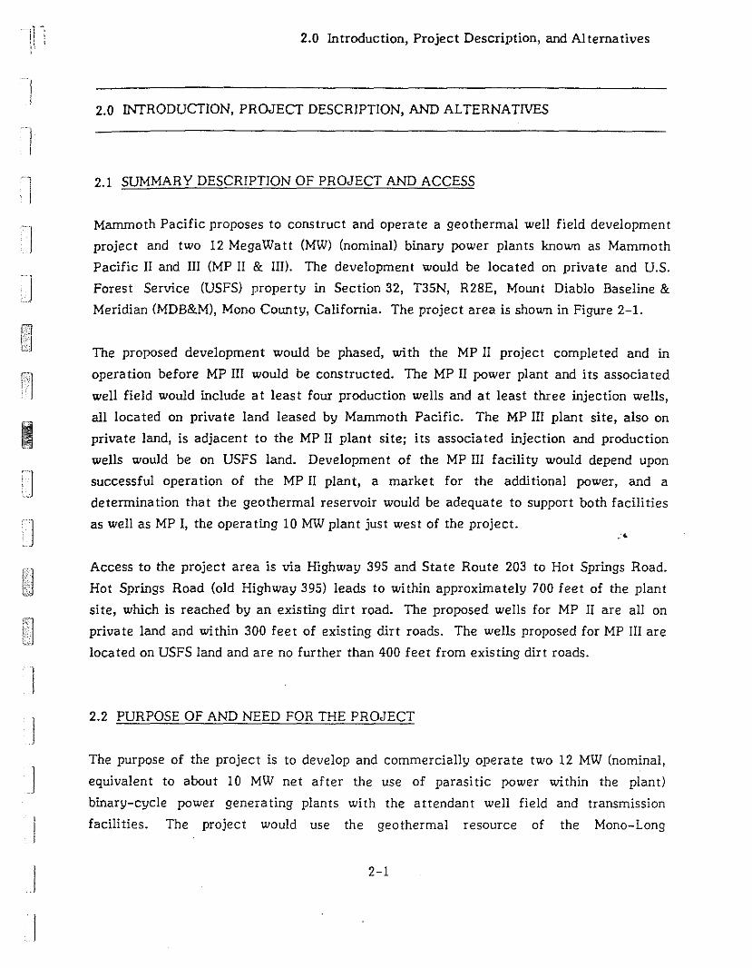
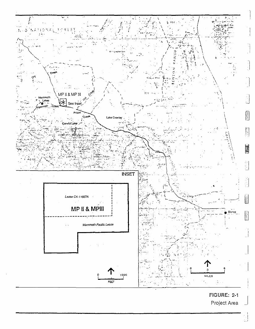
Mammoth Pacific proposes to construct and operate a geothermal well field development
project and two 12 MegaWatt (MW) (nominal) binary power plants known as Mammoth
Pacific II and III (MP II & III). The development would be located on private and U.S.
Forest Service (USFS) property in Section 32, T35N, R28E, Mount Diablo Baseline &
Meridian (MDB&M), Mono County, California. The project area is shown in Figure 2-1.
The proposed development would be phased, with the MP II project completed and in
opera tion before MP III would be constructed. The MP II power plant and its associa ted
well field would include at least four production wells and at least three injection wells,
all located on private land leased by Mammoth Pacific. The MP III plant site, also on
private land, is adjacent to the MP II plant site; its associated injection and production
wells would be on USFS land. Development of the MP III facility would depend upon
successful operation of the MP II plant, a market for the additional power, and a
determination that the geothermal reservoir would be adequate to support both facilities
as well as MP I, the operating 10 MW plant just west of the project..'4
Access to the project area is via Highway 395 and State Route 203 to Hot Springs Road.
Hot Springs Road (old Highway 395) leads to within approximately 700 feet of the plant
si te, which is reached by an existing dirt road. The proposed wells for MP II are all on
private land and within 300 feet of existing dirt roads. The wells proposed for MP III are
located on USFS land and are no further than 400 feet from existing dirt roads.
2.2 PURPOSE OF AND NEED FOR THE PROJECT
The purpose of the project is to develop and commercially operate two 12 MW (nominal,
equivalent to about 10 MW net after the use of parasitic power within the plant)
binary-cycle power generating plants with the attendant well field and transmission
facilities. The project would use the geothermal resource of the Mono-Long
2-1
]
1
\\
''7
,.j. \
\
,- <,
,\\
.'
-~,;.::....:t~>~:~:
'~~;~i~:~~~:,·~~;~·~'~-r' .
~ 'r:' .... ~'"
":.oj ,.
':;:; :
·'T.
7-,
I:~;; -. -.' ·~.i.:r:""-f --'-',-.--,.__ ....._.• ,~IS~O~._
:,."t '.I
'~"'",.:-.. ,_'
,-
~, ~"':''''',
/-'
·'t "
,~ ,/-':.~- .{,
, -..:.'~'- :;' :.,
, ~ ••. '.' .J.'.;~'•.
"_.~-
."
INSET
I
f../_~.:.:. ....:--..i.._.-,....
('
"',
I
//
. -- ~~,.
"~ .~.-, ~ ...... ·.,u
Lease CA-17667A
II111II
MP II & MPIll :_____ I
------______ I_________ ..J
2
: .1,_
r......,• ;c,(
. ""-- " ...:', V",-:
" \~-' '"'-
""~,
.~ ,
Mammolh Pacifk; Lease
..,-..;'.,;,,1.,
0~
! 3 •! !
!..IlLES
FEET
FIGURE: 2-1
Project Area J
1-
11 ', '
I]
I
I
]
I]
II
2.0 Introduction, Project Description, and Alternatives
Valley Known Geothermal Resource Area (KGRA) to produce approximately 20 MW of
locally generated power which would be fed into Southern California Edison's (SCE)
existing distribution system. The power would be generated to add to SCE's base load
capacity. It would not necessarily be used locally, because existing hydroelectric power
supplies most of the local demand (Robinson, 1987). According to the California Energy
Commission, SCE currently has adequate supplies of power, but will need additional
capacity by the mid- to late-1990s in order to maintain reliability of the power supply
(CEC, 1986).
Mammoth-Pacific has two power purchase agreements with SCE to purchase the power
produced by the project. Mammoth-Pacific, consistent with orders by the California
Public Utilities Commission, has proceeded to follow provisions of the Public Utility
Regulatory Policies Act of 1978 (PURPA), which encourage development of qualifying
cogeneration and small power production facilities. The purpose of the act is to
encourage new technologies and reduce the nation's dependence on oil. Long-term
reneWable resources like geothermal reduce the need to operate fossil-fuel generating
facilities. The existing Mammoth Pacific geothermal plant's power production saves
approximately 156,000 barrels of oil per year and approximately $3.5 million over more
expensive utility resources for power (Vinson, 1987).
For the parts of the project on U. S. Forest Service land, the need for the project is stated
by Congress in the Geothermal Steam Act of 1970, the Mining and Minerals Policy.•Act of
1970, FLPMA of 1976, and the National Materials and Minerals Policy, Research, and
Development Act of 1980. These acts direct the federal government to foster and
encourage private enterprise in the development of alternative energy resources within
appropriate environmental constraints. Toward this end, each lessee is required to
perform "... diligent exploration until there is a welles) capable of commercial production
on the leased land." (43 CFR 3203.5). The lessee is also required to complete a
commercial geothermal steam well within 10 years of the lease issuance or lose the lease.
2.3 BACKGROUND TO THE ErR: MAJOR ISSUES
Mammoth Pacific of Commerce, California, applied to the County of Mono in June 1986,
for a Conditional Use Permit (CUP) for the development of the MP II & III project. The
2-3
2.0 Introduction, Project Description, and Alternatives
Initial Study, first submitted with the application, was revised by the County on October
21, 1986. It indicates that the project may adversely affect the environment.
Accordingly, the decision was made by the County of Mono to require an Environmental
Impact Report (EIR). The Notice of Prepara tion (NOP) was issued by the County in
November 1986. The Bureau of Land Management (BLM) is the lead agency for federal
environmental review, and the EIR will also serve as an Environmental Assessment (EA) to
satisfy their requirements.
Concerns expressed by agencies, organizations, and individuals who responded to the NOP
deal 'Il:ith the foIIowing major issues:
Geothermal Resources. The geothermal resource is important to Hot Creek Ranch
and essential to Hot Creek Fish Hatchery and the recreational use of Hot Creek
Gorge. It is unclear to what extent the geothermal reservoir for MP II & III and the
source of the geothermal waters feeding Hot Creek are coupled, but if the
temperatures of the springs at Hot Creek are lowered even a few degrees, it could
have major impacts on the users of Hot Creek.
Water Quality. The project area is within the watershed of Mammoth Creek and Hot
Creek. Hot Creek is one of California's most important wild trout streams and also
contains a popular swimming area in Hot Creek Gorge. Degradation of its water
quality by sedimentation or release of large amounts of geothermal fluids would have..serious consequences for the aqua tic biota and for recrea tional uses of Hot Creek.
Visual Resources. The Mammoth Lakes area is known for its scenic beauty, and
preservation of scenic quality is important to the continued appeal of the area to
visitors and residents. Some people feel that geothermal plants within clear view of
Highway 395, a designated scenic highway, provide an incongruous industrial view out
of keeping with the natural beauty of the area. Furthermore, one of the goals of the
U.S. Forest Service is to decrease the visual impact of geothermal development along
the Highway 395 corridor.
Noise. The existing MP I geothermal plant is noisier than anticipated, and passers-by
on Hot Springs Road are aware of its noise. The new plants will be required to meet
noise standards· enforced by Mono County.
2-4
I
j
J
·jll"
Ii, .
]
1
]
I
2.0 Introduction, Project Description, and Alterna tives
Deer Migration. Several thousand deer winter in the valleys south and east of
Mammoth Lakes and have summer ranges either near Mammoth Lakes or in the high
valleys west of the Sierra crest. Development at the site has the potential to disrupt
the traditional migration routes of many of these deer.
Economic Effects. The economy of Mono County is dependent on tourism, especially
skiing. Development which would diversify the economy and provide increased,revenues for the County could benefit the County and its residents. An assessment of
the likely economic effects of MP II & III is provided herein.
2.4 REGULATORY FRAMEWORK
Discretionary approvals and permits from a number of agencies would be required for the
project. These are summarized in Table 2-1. In addition, this EIRIEA has been prepared
under CEQA guIdelines in response to the County's requirements. As indicated in the
Environmental Initial Study (see Appendix A), the project may result in significant
environmental impacts. Furthermore, this document is intended to meet the requirements
for an Environmental Assessment for use by the BLM in evaluating those parts of the
project on federal land.
.4
2.5 PROPOSED PROJECT
The proposed MP II & III project includes the phased development of two power plants and
appurtenant facilities. Each would include the drilling and operation of production and
injection well fields; the construction and operation of the related fluid conveyance
production gathering system, injection distribution system, and surface infrastructure;
and, the construction and operation of one 12 MW (nominal) binary power plant facility.
MP II, the project to be first constructed, would include an electric transmission line
leading from the power plant to the existing transmission line on Hot Springs Road.
Geothermal fluid, produced from up to five geothermal production wells completed in the
reservoir at an approximate depth of 500 to 700 feet for each power plant, would be
directed by surface pipelines to the proposed binary power plant. After hea t
2-5
2.0. Introduction, Project Description, and Altematives
TABLE 2-1: PERMITS AND APPROVALS
Agency
Mono County Office ofEnergy Management
Grea t Basin Unified APCD
California RWQCB,Lahontan Region
California Division ofOil and Gas
Permi tIApproval
Condi tional Use Permi t
Authority to ConstructPermi ts to Operate
Waste Discharge Orders
Notice of Intentto Drill
Facility
Both power plants; wells onpriva te land; transmissionline; pipelines on private land.
Both power plants; all wells.Both power plants; all wells.
Both power plants; all wells.
All wells.
Bureau of Land Management Plan of ExplorationPlan of DevelopmentPlan of InjectionPlan of Baseline Data
CollectionPlan for Production
SOURCE: Thomas, T. 1987.
All wells on federal land.
I
extraction, the cooled geothermal fluid would be directed from each plant by' surface
pipelines to up to four geothermal injection wells and injected into the subsurface
injection reservoir at an approximate depth of 2,000 feet. MP II would be completed and
operational before the construction of MP III would begin. A total of eight production
wells and eight injection wells is proposed for both phases of the project. Each plant
would occupy approximately two acres. Approximately 34 acres of private land and
24 acres of USFS land would be used in the development and operation of well fields for
the prbposed project. Figure 2-2 shows the proposed well field and plant site locations.
All the facilities for MP 11 would be on private land. The plant for MP III would be on
private land, but the well fields are proposed to be located on USFS land. The design life
of each plant is approximately 30 years.
2-6
I
'1 1-:: I
.:6. \
,,
'.
I~::-"'"I '.,....,
/' ',\ -"""II /
.:1 ,I I
, I ;- /
,
,el,. . '. ','
. \\1' .
!:;lI ,,
):I'
SOURCE: Mesquite Group Inc .. OCt. 1986
FIGURE: 2-2
Site Layout
J
2.0 Introduction, Project Description, and Alternatives
Electrical energy produced by the utilization facility would be directed to on-site
transformers. There it would be converted to the appropria te line voltage and delivered
to the existing Southern California Edison (SCE) Company's Casa Diablo Substation,
located approximately one-quarter mile northwest of the proposed sites of the MP Il & 1Il
power plan ts.
Construction of each project would occur over a nine-month period. Site preparation,
construction of concrete foundations, and preparation of pipeline supports would be done
during the first two months of construction. Well drilling would begin in month three and
last for four months. installation of pipelines would begin near the end of month four and
would be completed after eight months.
The project area is within the Mono-Long Valley Known Geothermal Resource Area
(KGRA) and is approximately 600 feet from the existing 10 MW (gross, at 38°F ambient
air temperature) MP I geothermal resource electric generating facility that has been
operating since 1984. There are no other existing geothermal projects in the vicinity of
the project.
2.5.1 PRODUCTION WELL FIELD AND GATHERING SYSTEM
Four production well locations are proposed for each of the MP Il & 1Il plants. They are
identified on Figure 2-2 as well sites MP 13-32, MP 23-32, MP 23A-32, and MP 24-32 for-.MP II ap.d well sites MP 12-32, MP 12A-32, MP 22-32, and MP 22A-32 for MP III. All well
sites proposed for MP 1Il are on USFS land. Well sites MP 12-32, and MP 22-32 and
MP 22A-32 have been approved for exploration by the BLM.
The design requirement for each proposed plant is about 5,000 gallons per minute (gpm) of
330°F geothermal fluid. Four wells have supplied the existing MP I plant requirement of
3,800 gpm, which equates to an average rate of 950 gpm per well. Based on this average,
five new production wells would be required for each new plant. A site for the fifth
production well, if needed, has not been selected. The actual nwnber of wells required
will depend upon the drilling and flow test results. If well production is less than about
950 gpm, more wells may be required. The locations of additional wells which may be
required are not shown in the si te plan.
2-8
I
1
I
Ij
j

·1' ~I ,I ., ,
Ij
I
]
!J
IJ
2.0 Introduction, Project Description, and Alternatives
2.5.1.1 Well Drilling and TestIng
At each proposed drilling site, a rig would move to a prepared pad. Each of the five pads
would cover 0.5 to 0.7 acre. At each pad, there would be a 50,000 ± gallon capacity,
plastic-lined reserve pit for the storage of waste drilling mud during the drilling period.
A typical drilling pad and equipment layout is shown in Figure 2-3. Final equipment
placement would depend upon the drilling rig used and the terrain.
The production wells are each designed to reach a total depth of 700 feet and would be
completed in the fractured rhyolite geothermal reservoir. Well casing would consist of
30-inch conductor to 10 feet, 22-inch conductor casing to 80 feet, 16-inch surface casing
to 350 feet, and completed with a 13-3/8-inch slotted production liner frDin 500 to
700 feet. All mud used during the drilling of each well would consist of a 8.6 to
9.0 pound-per-gallon weight gel. No hazardous or toxic mud additives are proposed to be
used. A list of drilling mud additives considered non-hazardous by the California
Department of Health Services is listed in Appendix B. A typical production well
completion diagram is shown In Figure 2-4.
A longer-term flow test of each new production well would be conducted to more
accurately determine well productivity. The test would consist of pumping the well for
approximately five days through an on-site test facility closed to the atmosphere, and
pumping the produced geothermal fluid through a temporary pipeline to the MP I power,-plant. There the fluid would be directed through the plant's cooled geothermal fluid
system Into the MP I injection reservoir. This is the same reservoir which would be used
by MP II & III. The well test surface facilities and temporary pipeline would be removed
when testing is completed.
Fewer than four production wells may be required, depending upon the drilling and flow
test results. If any well drilled as a production well lacks commercial potential, a
workover andlor deepening of the well may be conducted, or the well may be converted to
an observation or injection well, or the well may be abandoned (including filling and
capping).
2-9

~- - --0
,. Air Compressors2. Mud Tank3. Fuol Taf'l<4. WolLlr Taf'l<5. MJd SlOruga6. Gonorator7. Change House8. Accumulator9. MudPil10. Shalo Shaker1\. Rig Floor12. Draw Works13. Storago14. Dog House15. Catwalk16. Pipe Rack17. Eloctric Logger18. Mud Loggor19. Trailer House20. Trailor Ollice
2
DD
[J8
'" T I I ~
~
~ - 1RESERVI PIT
10-a
V- I I '"r-,
'0 I • II I
8I ,. I
11I 15 0 11
L ..J
" I II
8!t
"~
__ L_...1I 20 I I " I'- .J
IIII'---
ACCES-S ROAD
FIGURE: 2-3
Typical Drilling Pad and Equipment Layout

11-11
:, ', ,
'I-] i
1:10'
J
cJ 00'
26' hole
22'" API SIAl P<>e
20 112"' hole
36' hole~O· condooor
lS·,75bJl1.K55
13318"" retrievable hanger
13318",54.5 bAt K-55w/lumed dOYr'o buttresscoonedion. slot1ed liner(36 5101s per foot,2 117 x 1/4" slots)
w2l3" vaJ'0'9 OUIlelsw ~ Hi ANSI 300 wellhead
_t I.. : C(
, , .'·
"
· ., ,
-- :
· ,
"
·--
I I I
I I
I I II II I I
I II I II II I I---
350'
310'
690T,D,700
J
'J
j FIGURE: 2-4
Typical Production Well Completion Drawing

2.0 Introduction, Project Description, and Alterna tives
Each production well required by the project would require about 12 days of rig time to be
drilled. At least one day with the rig on the hole has been allowed for well cleanup and
initial flow testing into on-site tanks. The initial flow tests would be of short duration
(approxima tely two to four hours).
2.5.1.2 Wellhead and Downhole Facilities
Each well would be pumped using a deep well, 12-stage, water or mineral oil lubricated,
centrifugal, lineshaft turbine pump driven by a vertical electric motor located on top of
the well. The electric motor, mounted on top of the pump discharge head, is not expected
to exceed a height of 15 feet above the ground. A small control building (approximately
eight by 15 feet), would be located within approximately 50 feet of each well, and would
house auxiliary systems, motor switch gear controls and sensors, and transmitters for key
temperature, pressure, and flow rate data. These data would be measured for purposes of
process control, continuing resource data acquisition, safety, and environmental
protection.
The production of hot geothermal fluid from each lineshaft turbine pump would be
flow-rate controlled. Pressure limit sensors would also automatically shut down the pump
in the event of an excessively high discharge pressure, which could damage the IJumP, or
an excessively low discharge pressure, which might occur if a pipe ruptured. These and
other automatic shutdowns w,.'uld be equipped, ·as appropriate, with delays to avoid false. .
shutdowns caused by momentary conditions, and would require overrides during startup.
Two auxiliary systems would be used. The first is a lineshaft bearing lubrication system
which would pump lubricating fluid down the annular space between the lineshaft and
enclosing tube. It is planned that the lineshaft bearings would be either water-lubricated
or lubricated during pump opera tion by a fIc-;v of approximately two gallons per day (gpd)
of a food-grade (biodegradable) mineral oil. The second auxiliary system is a closed-loop
seal flush system which would be used to circulate a water/antifreeze mixture through the
mechanical seal on the pinnp lineshaft at the surface.
2.5.1.3 Gathering System
The permanent gathering systems for transporting hot geothermal fluid from the wells to
the power plants would use insulated pipelines routed as shown on Figure 2-2. Pipelines
2-12
I
I
I

1
1". ,
II.
II
j
]
J
j
I
!
2.0 Introduction, Project Description, and Alternatives
would vary in diameter from 10 to 14 inches. The size would be determined by the
amount of fluid being carried. Horizontal expansion loops (approximately 30 by 30 feet)
would be included within the pipeline every 250 to 350 feet. The pipelines would be
loca ted at or near ground level on concre te supports called sleepers and would be an
appropria te color to blend wi th the terrain. Where appropriate, berming of pipelines may
be used for visual screening. Downhole pumps in the production wells would deliver the
geothermal fluid to the plant at about 200 pounds per square inch gauge (psig).
2.5.2 POWER GENERATION
The proposed power plants would use hot geothermal fluids produced from the geothermal
production wells to generate electric power. Each power plant facility would be designed
to produce a minimum of 10 MW (net) of electricity under normal operating conditions.
The power plant would use a closed-system binary process cycle to extract heat from the
geothermal fluid pumped from the production wells. The geothermal fluid would not be
flashed or exposed to the atmosphere at any time during its utilization. After heat is
extracted from the produced geothermal fluid in the facili ty heat exchangers, the cooled
geothermal fluid would be transported from the power plant by a surface pipeline to the
injection well field facilities (see Section 2.5.3). Chemical treatment of the geothermal
fluid prior to injection would not be necessary.
•The project sponsor proposes to construct a radial flow turbo-expander binary Rankine
cycle system which would extract heat from the geothermal fluid in shell-and-tube heat
exchangers and transfer the heat to a hydrocarbon working fluid, isobutane in this design,
explained below. The heated isobutane would be expanded through a turbo-expander
generator system, converting the mechanical energy produced to electrical energy.
lsobutane vapor from the turbine exhaust would be condensed in air-cooled condensers.
The condensed isobutane would then be directed to a storage vessel (accumulator), from
which the cooled and condensed isobutane would be pumped to start the closed-system
binary cycle again.
The principal power generation facilities for the two plants would be constructed within
an area approximately 300 feet by 560 feet, as depicted on Figure 2-2 which identifies the
2-13
2.0 Introduction, Project Description, and Alternatives
proposed location of all significant surface development, utilization and injection
facilities, including: the production and injection well sites, power plant facility, access
roads, interconnecting pipelines, associa ted structures, electric transmission line and
on-site facility substation.
Figure 2-5 shows the power plant plot plan. The major equipment includes shell-and-tube
heat exchangers, a turbo-expander generator, air-cooled condensers, isobutane
accumulator, isobutane circulating pump, geothermal fluid injection pump, air
compressors, gas freeing compressor, lubricant coolers, transformers, and electrical
switchgear house. With the exception of the turbo-expander generator, these major plant
components would not be enclosed in structures. The turbo-expander structure would be
an open-ended enclosure with open sides about 10 feet above grade and will be
approxima tely 40 feet square and 30 feet high to the roof peak. The tU·<J banks of
air-cooled condensers would be used, each approximately 224 feet long by 60 feet wide
with an overall height of approximately 30 feet. Each bank of condensers would contain
39 cooling fans.
The proposed shell-and-tube heat exchangers would occupy a space approximately 50 feet
long by 20 feet wide and 20 feet high. The isobutane ac ::umulator would be a cylindrical
yessel approximately 70 feet long and 10 feet in diameter. The isobutane accumulator
would be placed on supports along its length and would rest about five feet off the ground,
. thereby reaching approximately 15 feet in height. .'
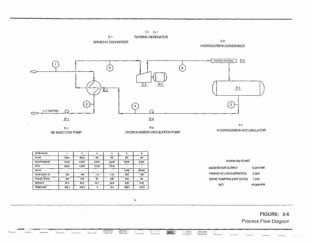
A process flow diagram depicting the mass flows of both the geothermal fluid and the
isobutane working fluid through the bir."ry power plant is provided as Figure 2-6.
Approximately 5,000 gpm of hot geothermal fluid for each plant would be pumped from
the production wells through pipelines to the tube side of a shell-and-tube heat exchanger
to heat the isobutane working fluid. The cooled (spent) geothermal fluid would not be
exposed to the atmosphere during the cycle but would be pumped, if necessary, directly to
the injection wells for subsurface disposal. The apparent loss of geothermal fluid volume
indicated on the mass flow diagram results from the cooling of the fluid through the
facility and does not result from consumptive use. There would be no difierence in the
·fluid mass produced and fluid mass injected.
2-14
]
]
I
JI
'-------' I...-...- ~ .._.....~ -::::-;:;:;;;_ .. _.I
SUBSTATION
AIR COOLERS AIR COOLERS
~SWITCH- HOUSE
PROPOSED PLANT MP IJ/ I - i-- PROPOSED PLANT MP IITURBO-EXPANDER I:;~gi~~EIL TURBO-EXPANDER
HEAT EXCHANGER D (EL 7316) D HEAT EXCHANGER
I I . : ~ 0GENERATOR I CONTROL ROOM GENERATOR
( ) ( )
ACCUMULATOR : ACCUMULATOR
AIR COOLERSII AIR COOLERS
I
!,I I 1--1'- I =--_ REIN.~ION PI~E_ _ J ' _
"-
"•
FIGURE: 2-5
Power Plant Plol Plan
E·l
BRINE/HC EXCHANGER
T-l G-l
TURBINE·GENERATORE-2
HYDROCARBON CONDENSER
> = 150 PSIA
P-'
5
ti
P·2
6
E·2
V·l
o
P-'RE ·INJECTION PUMP
P·2
HYDROCARBON CIRCULATION PUMP
V-I
HYDROCARBON ACCUMULATOR
S1REAMNQ , 2 , • , ,FLUID eo" eo" He l1e '" He
FlOW1000.l-lR 2,150 2,250 2,0<40 2.CJ.40 2.().(O 2.~O
GI'M 5,000 .(,600 1,13l:J 7,010
IY',HA .(,0110 .lIll,OOO
lnY'{OEG F) 330 '" ,,. ,,, 200 ,MpnESS. {f'SIAJ 220 170 " 560 500 02
DENSITY 56' .., 32.7 326 ,OS 0."
!Jf.'OTU.,.lR "52 '02 , 0 '.0 ,... 3250
•
- - - -__ ___" !\':"';iC"':) {'j!J'fJC0\ (c . ", IIII:J ~-
10 M'Ne Net PlNH
GENERATOR OUTPUT lJ.B7S KW
PARASITIC LOAD {ONSITESj 2,625
BRINE PUMPING (OFF SITES) 1.250
NET 10,000 KW
FIGURE: 2-6
Process Flow Diagram
I)i
l
j
J
2.0 Introduction, Project Description, and Alternatives
The equipment containing the isobutane working fluid would be protected from
overheating and fire damage by a fire resistant insulation or cement. Such equipment
includes the working fluid accumula tor vessel, the working fluid-to-brine heat exchangers
and the working fluid circulating pump suction lines. A fire water system with hydrants
and fire hoses would also be installed to assist in cooling equipment, if necessary. The
isobutane working fluid air-cooled condensers would be loca ted on top of a steel
supporting structure about 20 feet above grade. The structural steel columns and beams
would be fireproofed against fire damage for two hours.
One building would be constructed to house the control room (CR) to serve both plants.
The CR building would house the controls for the facility and space for plant operating
personnel. The CR building would be a one-story structure approximately 20 feet tall and
would occupy about 3,000 to 5,000 square feet. Both staff and facilities from the existing
MP I plant would be used to provide clerical, administrative, and maintenance services for
the MP II & III plants, so that new warehouse, workshop, and administrative facilities
would not be constructed.
Wa ter and sani tary disposal (septic) systems would be provided for the buildings. As there
are no known potable water wells on the proposed power plant site, and as the site is
outside the water service area of the Town of Mammoth Lakes, a water storage tank
would be constructed to store water delivered to the site from either the existing MP I
groundwater well located nearby or from a reverse osmosis treatment unit which lfould be
constructed on-si te to trea t cooled geothermal fluid. The wa ter storage tank would also
serve as an emergency water source for safety showers and fire-fighting purposes. The
water tank volume is estimated at 50,000 to 500,000 gallon capacity. Final tank volume
would be de termined during engineering design of the facility. There would be no
consumptive water use for power plant cooling as air-cooled condensers would be used.
The expected potable water requirement for the facility, based on an' estimated manpower
requirement of six people, would be about 115 gallons per day. Bottled water would be
furnished for drinking during construction and production operations.
2-17
2.0 Introduction, Project Description, and Alternatives
The power plant facility area will be diked and drained to a catch basIn, located west of
the facility, of at least 250,000-gallon capacity. The catch basin would collect plant
runoff and would be available for emergency spill containment. The entire use facility
would be fenced.
All facilities will be constructed to meet or exceed applicable building codes and industry
standards.
2.5.3 ELECTRICAL TRANSMISSION LINES
Generated electrical power would be transmitted from the facility substation to the
Southern California Edison (SCE) Casa Diablo Substation, located approximately
one-quarter mile northwest of the proposed MP II & III power plant site. The generated
power will be transmitted via a new power line to the MP I plant, and then to the Casa
Diablo substation via an existing power line (see Figure 2-2). The new power line would
require six wooden poles and would be near existing roads.
2.5.4 INJECTION WELL FIELD AND DISTRIBUTION FACILITIES
Assuming that the MP I project ratio of three injection wells to four production wells is
maintained, the proposed MP II & III project would require at least six injection wells.
The proposed locations for eight injection wells are shown in Figure 2-2:. Wells
MPI 43-32, MPI 43A-32, MPI 52-32, and MPI 52A-32 would serve MP II and all would be
located on private land. Wells MPI 42-32, MPI 42A-32, MPI 42B-32, and MPI 42C-32
would be used for MP III. They are located on U.S. Forest Service land.
2.5.4.1 Well Drilling and Testing Description
At each proposed drilling site, a rig would move to a prepared pad with a 50,000:,: gallon,
plastic lined reserve pit for the storage of waste drilling mud during the drilling phase. A
typical drilling pad and equipment layout would be similar to that discussed earlier for
production well drilling (see Figure 2-3). Final equipment placement would depend upon
the drilling rig used and the terrain.
2-18
I
l1
]
I
I
Jj
1 :
1j ,
··11
)
]
J
I
2.0 Introduction, Project Description, and AI terna tives
The injection wells have been designed to reach a maximum depth of 2,000 feet and would
be completed in the Bishop Tuff geothermal injection reservoir. Well casing would consist
of 30-inch conductor to 10 feet, 22-inch conductor casing to 120 feet, 13-3/B-inch slotted
liner to 1,000 to 2,000 feet. All mud used during the drilling of each well would consist of
a B.6 to 9.0 pound-per-gallon weight (ppgw) gel. No hazardous or toxic mud additives are
proposed to be used.
Following well drilling, the well would be cleaned up and an initial flow test into on-site
tanks will be conducted in much the same way as the production wells are tested. An
initial injectivi ty test may also be conducted by injecting the geothermal fluid produced
during the initial flow test back into the well. Finally, a longer-term flow test of each
injection well may be conducted to more accurately determine the well's injectivity
and/or productivity. This test would be similar to the longer-term production well flow
test.
Fewer injection wells may be needed, depending upon actual drilling and injectivity test
results. Expectations are that three injection wells for each plant may suffice, with the
fourth well providing standby capacity. If any well drilled as an injection well lacks
commercial injection potential, a workover and/or redrilling of the well may be
conducted, or the well may be converted to an observa tion well or abandoned. If any well
drilled as an injection well were to indica te commercial production potential, it could be
converted to a production well and another injection well would be drilled to replace it..<
2.5.4.2 Injection Pumps and Gathering System
Residual, cooled geothermal fluid from the plant would be pumped to the injection wells
through insula ted pipelines having diame ters ranging from 10 to 14 inches. The injection
pump would be an above ground, horizontal centrifugal pump driven by a variable speed
electrical motor. It would be located within the power plant area and would be about five
feet high by 10 feet long. The pipelines would be at or near ground level on sleepers and
would be an appropriate color to blend with the terrain. Where appropriate berming of
pipelines may be used for visual screening. Each well would be moni tored as to injection
rate, temperature and pressure in order to aid in process control and resource
management.
2-19
2.0 Introduction, Project Description, and Alternatives
2.5.5 ABANDONMENT
lf operation of a well were to indica te tha tit no longer produces geothermal fluid in
commercially viable quantities and is not suitable for reworking as an injection well, the
well wouid either be abandoned or it could be used as an observation well. Abandonment
of the well would entail specified procedures for plugging and capping that would:
hal t the flow of fluids and gases to the surface;
prevent the contamination of groundwater resources and mixing of groundwaterbetween aquifers; and
avoid creation of safety hazards.
California Division of Oil and Gas (CDOG) procedures for plugging and abandonment
would be strictly observed for wells on private property. Similar procedures are required
under GRO Order 3 by the BLM for wells on USFS property. The deep portions of the well
in the production zone would be plugged with cement. The casing would be cut off at
least six feet below the ground surface and a steel cap would be welded on the
underground casing.
The sumps would be drained of liquids and these liquids would be trucked to a reinjection
well or, if toxic, disposed of a t a Class II was te site. Muds would either be removed to a
Class II waste disposal site or dried and buried in the sumps. Sumps would then be covered
with native soils, contoured and revegetated. All equipment and structures at· the pad
would be removed. The pad site would be regraded and revegetated.
I)
I~ J
When the entire facility is ready for decommissioning after its approximately 30-year
design life, the wells would be abandoned as described above under the procedures
outlined by CDOG or the BLM. The plant itself would be decommissioned under guidelines
established by the County in the CUP. J2.5.6 FIRE PROTECTION
During the construction phase all safety regulations would be followed and portable
fire-fighting equipment capable of extinguishing small grass or paper fires would be
2-20
j
J
)

'1-I 'I \
T];
It
I
I
J
2.0 Introduction, Project Description, and Alternatives
maintained on site. The power plant would be designed in accordance with applicable
Codes (e.g., 1976 and 1982 Uniform Fire Codes, California State Resources Code) and
sound engineering practice.
The leak detection and monitoring program would include:
addition of a gas odorant to each fill of hydrocarbon working fluid to facilitate leakdetection;
routine inventory analysis of hydrocarbon working fluid losses;
periodic leak detection surveys with portable detection equipment;
repair or replacement of significantly leaking equipment;
installation of block vales and compressors to evacuate hydrocarbon working fluidfrom the system prior to maintenance operations; and
use of hydrocarbon leak detection sensors and alarms.
In the event a working fluid leak is ignited, the equipment containing the working fluid
would be protected from overheating and fire damage by a fire resistant insulation or
cement. Such equipment includes the working fluid accumulator vessel, the working fluid
to brine exchangers and the working fluid circula ting pump suction lines. The working
fluid air coolers will be located on top of a steel supporting structure some 20 feet above
ground. The structural steel colunms and beams will be fireproofed against fire damage
for two hours. This is the standard petroleum refining practice where flammabl~ liquids
are handled. The power plant facility will be bermed for emergency spill containment.
It is standard practice to let a liquefied petroleum gas fire burn and protect the
equipment. Isolation valves and drain piping are sometimes used to drain tanks,
exchangers, etc., so that the burning time may be reduced. Where practical, this practice
would be followed. Relief valves which discharge through pipes to a safe elevation would
protect equipment from exceeding design pressures.
Fire control equipment would include: 1) water storage tank (estimated 50,000 to 500,000
gallon capacity); 2) fire pump and accessories, including: electric fire pump with ba tteries
and charger, diesel fire pump with diesel fuel system, jockey pump controllers; 3) fire
protection apparatus including: fire hydrants, monitors, and valves; fire hoses; automatic
2-21

2.0 Introduction, Project Description, and Alternatives
sprinkler for the control building; fire line pipes and fittings; and 4) fire alarm system,
including; control panel, isobutane detectors, ultraviolet flame detectors, and ionization
detectors.
Portable fire extinguishers would be installed throughout the plant area and in buildings
for use on small grass or paper or refuse fires or smoldering si tua tions as may arise.
Standard first aid equipment would be on hand for any burn victims.
2.6 ALTERNATIVE PROJECT
The project sponsor has proposed an alternate power plant design using Ormat Energy
Converter (OEC) units. An alternative location for the plant has also been proposed.
Figure 2-7 shows the alternate site layout.
Other power plant features such as the control room, sanitary systems, and water supply
system would be the same as for the proposed project.
2.6.1 WELL FIELD AND GATHERING SYSTEM
]
I
]
The production
project.
well field and ga the ring system would be the same as for the proposed.4
2.6.2 POWER GENERATION
Twelve modular binary heat extraction and turbine generator units, (OEC units), would
generate electricity in a cascaded energy extraction system utilizing isopentane as the. . .working fluid. Isopentane vapor from each OEC unit turbine exhaust would be condensed
in air-cooled condensers. The condensed isopentane would be used in the closed-system
binary cycle. The power plants would be constructed within an area approximately 340
feet wide by 580 fee as depicted on the Aliernate Power Plant Plot Plan (Figure 2-8).
2-22]
]

/ ' ...., ...,-----' .: \'~
].•r=
(
<. •• ,,, ...........
'.•.~.. ~...., ..,;....,
I1
J
I
CE SUBSTA~ION'
MAMMOTHWEll ~1
.. 4 \
.,
ayoutSOURCE'M. esquite Group Inc. and .EnVIronmental Managemenl Associates I, nco
FIGURE: 2-7
Alternate Site L
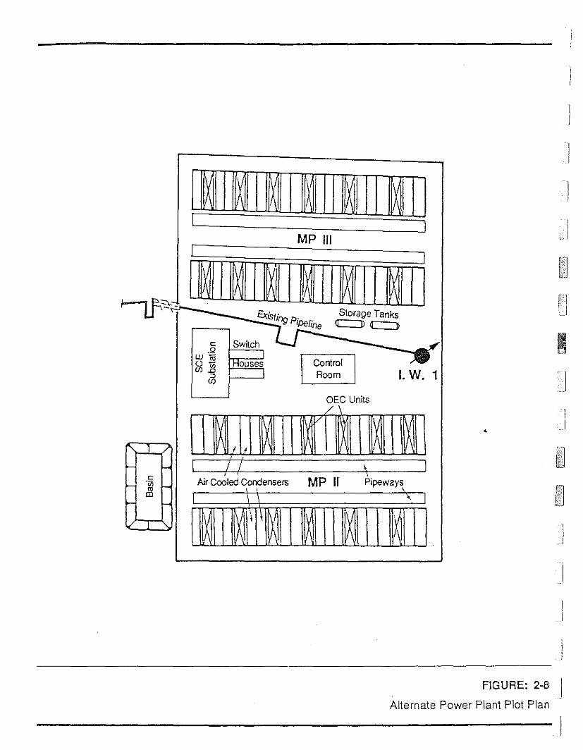
1\I):
11\
IJ II IIIII !' ,
iIMP 1/1
!"" I, Ii ,
~"""--~...
Existing PiPerStorage Tanks
-,.c::=:::D C::J>;...; Jne
c: Sw~ch -..QI
~Wn;0- IHouses
I. W. 1CfJ.13 I Room:JCfJ
DEC Units/"V
\II I'" ] /' ;
I1 ;' / \l-II 1
MP II Pipeways,c: Nr Cooled Condensers·Vi
"- J.- ttl r-
tIl~ t-
\1\ If l~ lX I~j 1\1V "-. 1\ f\
•
)
j
I
FIGURE: 2-8 J
IAlternate Power Plant Plot Plan
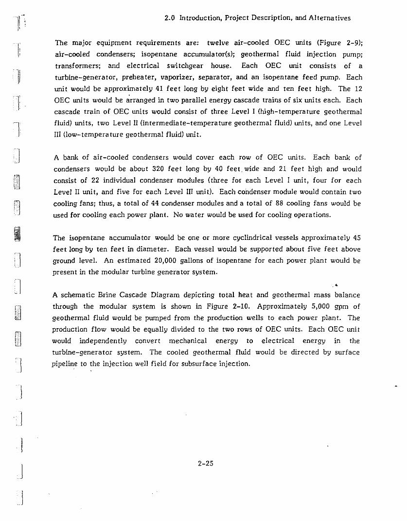
11
Ii
II
2.0 Introduction, Project Description, and Alternatives
The major equipment requirements are: twelve air-cooled DEC units (Figure 2-9);
air-cooled condensers; isopentane accumulator(s); geothermal fluid injection pump;
transformers; and electrical switchgear house. Each DEC unit consists of a
turbine-generator, preheater, vaporizer, separator, and an isopentane feed pump. Each
unit would be approximately 41 feet long by eight feet wide and ten feet high. The 12
DEC uni ts would be arranged in two parallel energy cascade trains of six uni ts each. Each
cascade train of DEC units would consist of three Level I (high-temperature geothermal
fluid) units, two Level II (intermediate-temperature geothermal fluid) units, and one Level
III (Jow-temperature geothermal fluid) unit.
A bank of air-cooled condensers would cover each row of DEC units. Each bank of
condensers would be about 320 feet long by 40 feet, wide and 21 feet high and would
consist of 22 individual condenser modules (three for each Level I unit, four for each
Level II unit, and five for each Level III unit). Each condenser module would contain two
cooling fans; thus, a total of 44 condenser modules and a total of 88 cooling fans would be
used for cooling each power plant. No water would be used for cooling operations.
The isopentane accumulator would be one or more cyclindrical vessels approximately 45
feet long by ten feet in diameter. Each vessel would be supported about five feet above
ground level. An estimated 20,000 gallons of isopentane for each power plant would be
present in the modular turbine generator system.
"
A schema tic Brine Cascade Diagram depicting total heat and geothermal mass balance
through the modular system is shown in Figure 2-10. Approximately 5,000 gpm of
geothermal fluid would be pumped from the production wells to each power plant. The
production flow would be equally divided to the two rows of DEC units. Each DEC unit
would independently convert mechanical energy to electrical energy in the
turbine-generator system. The cooled geothermal fluid would be directed by surface
'J pipeline to the injection well field for subsurface injection.
J
]
.1
2-25
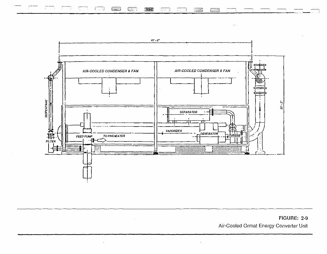
---,~ ~::=:iJ c=J ~-, _~
l,
~
'1
AIR-COOLED CONDENSER & FAN
I
"I S£P~R~
//;I;~>:
~->:,~;'///Z.,~·,
AIR-COOLED CONDENSER & FAN
F££DPUMP
",.,'
I~
I~m -l .~-" I----L m _; ~
-- - TOPR£NEAT£R~{?}I 1/$1Zi%/"z@?;;1 ~l~t:;%b'lD%z % ,
I 41'-0". Ij. J---~';+,. II I erN
~g~
FIGURE: 2-9
Air-Cooled Ormat Energy Converter Unit
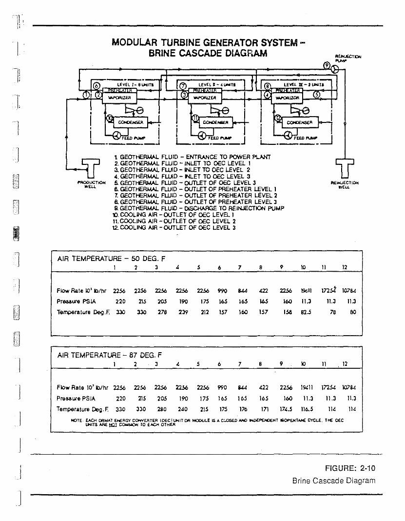
LEvEL II - 4 LHTILEVElI-6I,....,TI
9
MODULAR TURBINE GENERATOR SYSTEMBRINE CASCADE DIAGRAM
----6
I
11
I:
1
fI'AOOUCTK>HWEll.
t GEOTHERI.W. FLUID - ENTRANCE TO POWER PLANT2. GEOTHERMAl. FLUID - INLET TO OEC LEVEL 13. GEOTHERMAl. FLUID - INLET TO OEC LEVEL 24. GEOTHERMAl. FWD - RET TO OEC LEVEL 35. GEOTHERIML FLUID - OUTLET OF OEC LEVEL 36. GEOTHERI.W. FLUID - OUTLET OF PREHEATER LEVEL 17. GEOTHERMAl. FLUID - OUTLET Of PREHEATER LEVEL 28. GEOTHERMAl. FLUID - OUTLET Of PREHEATER LEVEL 3Q GEOTHERMAL FLUID - DlSCHARGE TO REINJECTION PUMP
l'J. COOLING AIR - OUTLET OF OEC LEVEL 111. COOLING AlR - OUTLET OF OEC LEVEL 212. COOLIN3 IIJR - OUTLET OF OEC LEVEL 3
AEiflUECTl~wEll.
] AIR TEMPERATURE - 50 DEG. F1 2 3 4 5 6 7 B 9 10 11 12
I Flow Rate 10' Ib/hr 2256 2256 22S6 22S6 2256 990 844 422 2256 )';lOll mst 10784
Preaaure PS tA 220 215 205 190 175 I~ I~ \6.5 11>0 11.3 11.3 11.3
Ten;perelure ~.F. :l3O :l3O 278 239 212 157 11>0 157 lsa 82.5 78 80
)
I
)
J
J
J
AIR TEMPERATURE - 87 DEG. F1 2 . 3 4 5 6 7 8 9 lO 11 12
Flo'" Rete 10' IbIhr 2256 2256 2256 2256 2256 1'90 U4 a2 2256 190:11 172.54 10784
PreS<lure PSIA 220 215 205 190 175 165 165 165 11>0 11.3 11.3 11.3
Temperature Deg. F. 330 330 280 240 215 175 176 In 174.5 116.5 114 114
NJTE_ EACH OR.....T ENf.AG't' COHVEATER IOfCILfofIT OR MCOULE LS A C:..DSEO AHl)~T ISOPf.HTAJfIE CYCU. THE O£CLotillS ARE: tt.::U COWIolOfoj TO EACH OTHER
FIGURE: 2·10
Brine Cascade Diagram
2.0 Introduction, Project Description, and Alternatives
2.6.3 ELECTRICAL TRANSMISSION LINES
The electrical power would be transmitted from the facility substation to the MP 1
substation via a new power line requiring approximately 10 to 12 wooden poles. It would
follow an approximately straight line from the MP 11 & III substation to the MP I
• substation.
2.6.4 INJECTION WELL FIELD AND DISTRIBUTION FACILITIES
The proposed locations for eight injection wells are shown in Figure 2-7. Wells MPI
43-32, MPI 43A-32, MPI 52-32 and MPI 521-32 would serve MP II. All would be loca ted
on private land. Wells MPI 42-32, MPI42A-32, MPI 42B-32 and MPI 42C-32 would be used
for MP Ill. They are located on USFS land. The location of MPI 43A-32 is slightly
northwest of its location for the proposed project. Other well locations would be
unchanged.
I1
2.6.5 ABANDONMENT
Abandonmen t procedures for the al terna live would be the same as for the proposed
project.
"
2.6.6 FIRE PROTECTION
Fire protection procedures and equipment would be the same for the alternative as for the
proposed project.
2.7 NO ACTION ALTERNATIVE
The No Action Alternative would prevent the construction and operation of the proposed
MP II & III project.
2-28
]
Jj
j
I
j
n,1iI '
3.0 AFFECfED ENVIRONMENT
r] 3.1 PHYSICAL ENVIRONMENT
'1 3.1.1 GEOLOGY, GEOLOGIC HAZARDS, AND SOILS
3.1.1.1 Regional Geology
3.0 Affected Envirorunent
I
j
I
The MP II & III site is located near Casa Diablo in the south-central part of the Long
Valley caldera, an elliptical depression about 19 miles from east to west and 10 miles
from north to south. The eastern half of the caldera is a broad valley with low relief.
The western part, an embayment into the Sierra Nevada near the town of Mammoth
Lakes, is an area of higher relief. A hilly area in the western-central part of the caldera,
the resurgent dome, was formed of post-caldera rhyolite flows which have been uplifted
and faulted. An annular moat is located between the caldera rim and the central
resurgent dome (Sorey, 1987a).
Research done in the area has been summarized by Hill et a!. (1985) in an article written
to describe recent advances in understanding the Long Valley caldera. The f9Jlowing
information, unless cited from another source, has been taken from that article. For
more details and complete citations of original sources, the reader should refer to the
article and its bibliogyaphy.
Volcanism within the Long Valley region began 3.2 million years (m.y.) ago when the
Sierra Nevada Mountain Range began to rise. Early eruptions in the region were mostly
basaltic, but near the present site of Long Valley caldera, more viscous materials like
rhyolite were erupted. The roof covering the magma chamber erupted violently 0.73 m.y.
ago and 144 cubic miles of magma was ejected mainly as ash. The ash deposits, known as
the Bishop Tuff, covered more than 575 square miles. They reach thicknesses up to 5,000
feet deep within the caldera.
After formation of the caldera, continuing volcanic activity from the Long Valley system
was confined to the caldera where the resurgent rhyolite dome was formed. Subsequent
3-1

3.0 Affected Environment
eruptions from the Long Valley magmatic system and the younger Mono-Inyo magmatic
sys tern resulted In a complex sequence of basalt to rhyolite flows wi thin the annular
moat. A geologic map of the area and an associated cross-sectional view across the
caldera are shown in Figures 3-1a and 3-1b, respectively. The project area is near Casa
Diablo, shown in both figures. The bedrock at Casa Diablo is basalt with the rhyolite from
the resurgent dome immediately to the north. AlJuvium and lake sediments overlie the
rhyolite and basalt in some areas east of Casa Diablo.
3.1.1.2 Geologic Hazards
Long ValJey caldera is one of the most seismically and volcanically active areas ill
California. Seven earthquakes greater than magnitude (M) 5.5 (see Figure 3-1 and
Table 3-1) and hundreds of smaller events have occurred since 1978. During the same
period, the resurgent dome has been uplifted. Researchers are studying the area
intensively, but no consensus has been reached as to the exact cause of the earthquakes
and renewed doming. There is general agreement that magma is moving upward under the
resurgent dome and/or south moat. A variety of geological hazards, discussed below, are
potential problems in such an area.
Fault Rupture. The actual project site is within an area given a rating of "highest
surface faulting hazard potential" in the lnyo National Forest Geologic Resource
Inventory (Merrill and Seeley, 1981). That rating means that the site is within .•
TABLE 3-1: LONG VALLEY EARTHQUAKES OF MAGNITUDE 5.5 AND GREATERSINCE 1978
I
1234567
October 4, 1978May 25, 1980May 25, 1980May 25, 1980May 25, 1980September 30, 1981November 23, 1984
Magnitude
5.76.16.06.16.25.75.8
J
SOURCE: Hill et a!. 1985. Journal of Geophysical Research.
3-2 !I

'1I:
'"
r'OIlO..,..,'00..,..,00'
'00
'00
'00
,nB
A'
,r
---l
... ' .. ~t
1''''[
2.3.4.5
I
IIIIl
/Iua ""
FIGURE 3--1c: Elevation History of bendlmark near CasaDiablo Hot Springs and summary of seismic activity.Numbers refer to M > 5.5 quakes shown on Figure 3~1a.
--__ ftESUI'lGCHT OOiolt
I
.p{
Hartley Springs FaultHilton Creek FaultLaurel Creek FaultMono Lake FaultSilver Lake FaultWheeler Crest FaultCasa DiabloHoI Creek
o.,roo 'm
FIGURE 3-1a: Geologic map of Long Valley Region
HSFHCFLCF MLF SLFWCF-
CDHC-
IXI"l.A.....TtON_0-/~Mo---.,. "","Ieill'tTO ~ ••••tl
f,.anW 00...·,...lit. ww'''''./0....'rtl,.,~n.VA.LL.EY 0 fl.lr "",I'ttla
IT'TEW [dJOII" ..,,, ,,,,-'III'( "'llt. llo.r , .. 1011I1'
\. f tli , lin ..
~;::'.;;. 111 "Oil 1c: 1r.1 I~'
,. lli't $.$ ••lIkll tlnc:e 111'
I
J
I
..-.', " ....
/-,-,~':"'*"!'-~... , ... ",. ., ,...... "",..,FIGURE 3~1b: Cross Section A - At as sho'NT'l on Figure 3-1 a.
FIGURE: 3-1a, band c
SOURCE: HiU et aI., 1985, Journal of Geophysical Researd1

3.0 Affected Envirorunen t
Analysis revealed highly erodible soils similar in character to those described above
(Bureau of Land Management, 1986b). Because of their similar appearance and origin, it
is assumed that the soils throughout the project area are similar in general nature to those
which were sampled and that they are highly susceptible to erosion by wind, water, and
vehicular traffic.
3.1.2 HYDROLOGY AND WATER QUALITY
The single most important concern about the development of geothermal projects in the
Shady Rest-Casa Diablo-Hot Creek area is their potential for adversely affecting the
flow of thermal water to Hot Creek. There is also the related concern that there may be
a connection between shallow groundwater and the geothermal reservoir so that even the
flow of non-thermal water supplying the springs at the headwaters of Hot Creek could be
affected by pumping from the geothermal reservoir.
3.1.2.1 Models of the Geothermal Reservoir
The best way to answer questions about likely cormections between different aquifers in
the area is to have a "model" which accurately describes the distribution of heat, water,
and steam. In this sense, a "model" is a working theory which describes, either
mathematically or by analogy, how a process works when the process cannot be directly
observed. Any model must be consistent with the observed characteristics of the area .. '
The information available in the Shady Rest-Casa Diablo-Hot Creek area includes data
about the temperature, flow rates, chemistry, and isotopic characteristics of water at
some features in the area; but there is not enough information to definitively support one
model of the system. Scientists working in the area have proposed two different models,
both of which can account for the observed data.
The first model, called the La teral Flow Model, is based on the assumption. tha t the
geothermal fluid originates near the western or southwestern edge of the caldera and
moves east through the caldera. Under this model, the hot water would travel through the
rhyolite reservoir until it encountered a fault. It would then migrate along the fault until
it encountered rock with high enough transmissivity for the flow to be maintained. This
model assumes a single hot water resource supplying all the thermal fea tures in the area.
The characteristics of the water at each feature would be the result of mixing thermal
3-6
I
IJIJ
!I
11-,, II'
11
j
3.0 Affected Environment
water and meteoric water in different proportions. This model implies that production of
hot fluids from one zone and injection into another could result in pressure and/or
temperature declines in nearby areas that depend on fluid from the same lateral zones.
The second model is known as the Upwelling/Fracture Flow Model. Under the scenario
proposed by this model, the nearly vertical faults which cut across the area serve as
conduits to carry heated water up from deep reservoirs. This would suggest poor
hydraulic connection between reservoirs for each thermally active area and little
potential for interference between the Casa Diablo area and Hot Creek Hatchery or Hot
Creek Gorge. A variation of the thermal upwelling/fracture flow model has been
suggested (GeothermEx, 1986). Their model is one in which the fluids move from south to
north, roughly along the strike of the major faults.
The following discussion of the surface and subsurface hydrologic resources briefly
summarizes the current knowledge about the area. It is a summary of a report on the
hydrology of the project area written by Berkeley Group Incorporated (BGI). The report is
available from the Mono County Energy Management Department. Details and references
can be found in the BGI report.
3.1.2.2 Surface Resources
The project site is contained entirely within the Mammoth Basin, an ,ttea of
approximately 60 square miles which is defined by the surface watershed of Mammoth and
Hot Creeks. These creeks flow across the Long Valley caldera to the Owens River and
then into Lake Crowley. Other small creeks draining the caldera include Dry Creek,
Little Hot Creek, and Convict Creek. in addition to the creeks which drain the area, a
number of springs contribute to surface flows. Locations of the creeks are shown on
Figure 3-2. Springs and selected wells are shown on Figure 3-3. Flow data,
temperatures, and water chemistry analyses are summarized in Table 3-3. The table
gives average values which do not reveal seasonal changes.
The following discussion of surface hydrology describes these features: an unnamed creek
which drains the project site, Mammoth Creek, Hot Creek, and five springs or groups of
springs which ultimately flow into Hot Creek.
3-7
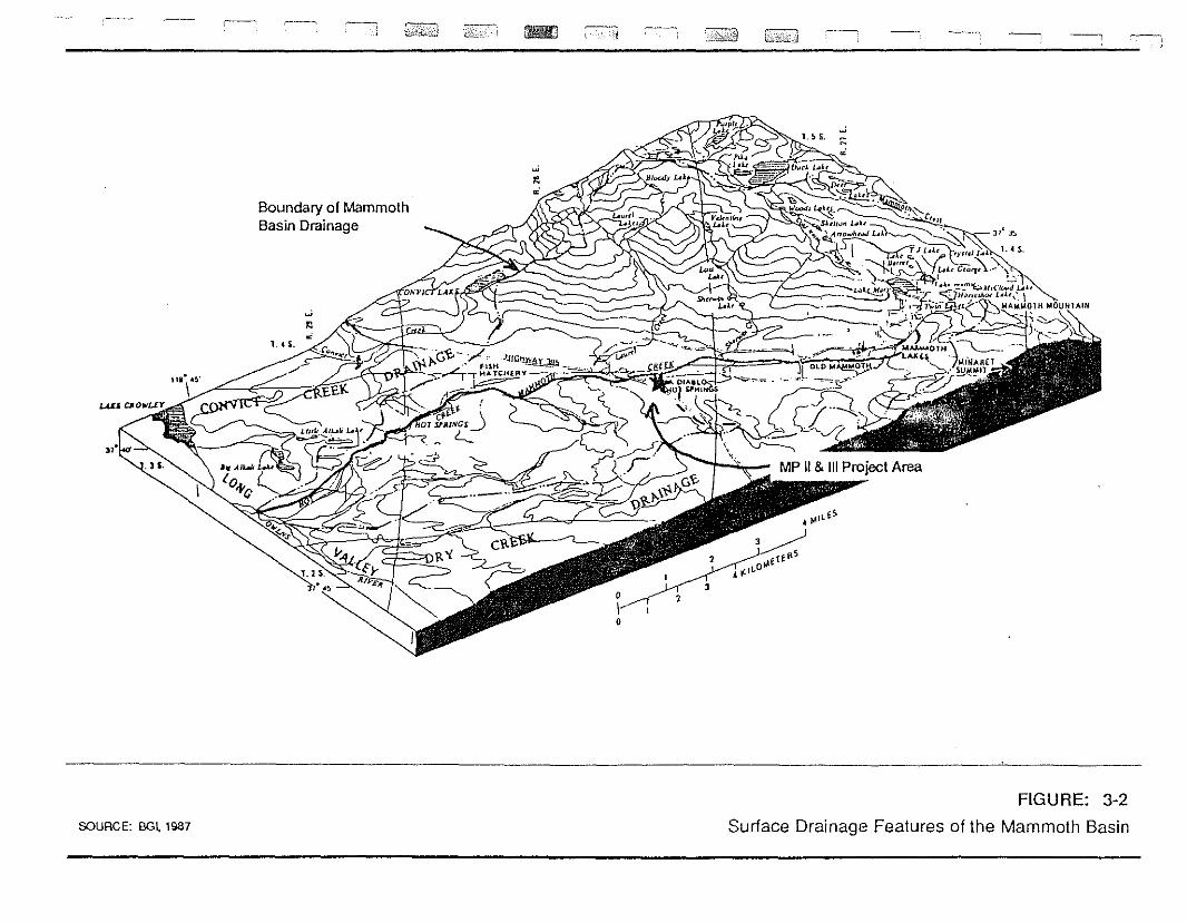
SOURCE: BGI. 1987
Boundary of MammothBasin Drainage
-
FIGURE: 3-2
Surface Drainage Features of the Mammoth Basin

~ - ---~ ---' _0 '1'-'
",.,
An
"
HCF•
G(<f!-'f-
0-,~,,,'
Hal Creek',' Ranch
H1 .-.~.,'" H2,3CD
•
"
-.'.
• F
,-".
"••<.
'~F
,' .
". -',,:, .-~.
F
County Buildings
'~.,"
Project AreaI' . UM-1
.,'
. ;,:'..:-.i:.;;~".'-:~
,Creek
i·
p''> .,..~,... \
.J .~.>'
i! . 'C.o. " ',".Y~'. '} ,> \ "~;';:
..2"'~,.';, .:,\\i
,......._.,~-.,.~ j\.;"..~ "
, '
,.,<
"
i ....~.,..: ..,,"<.
u' .',.. ,"
'.~
,. '
;.,.:':'j ~y_; : ,I Shady Rest~ ,-,.,'.' ,~ )~" A' ..
·:'.~:~~~;i:·'·:·,~ .. ,.~:,. ~ .",.
,,·,',t:,:;;,:' .,"'''',.•..••".
-.;.:
"
LEGEND
"
"; .
ABCOCOGCONSCOSSCHSCRCScwF
Spring feeding Hoi Creek HalcherySpring feeding Hot Creek HatcheryCasa Diablo GeyserCasa Diablo North SpringCasa Diablo South SpringChance SpringChance RanchCollon SpringHatchery area weltFumarole
H1 Spring fceding Hot Creek HalcheryH2,3 Spring feeding Hot Creek HatcheryHBP Hoi Bubbling PoolHC-1,3 Spring al Hot Creek GorgeHC-2 Spring at Hot Creek GorgeHCF Hot Creck FlumeM-t Deep wellMCF Mammoth Creek FlumeMS Meadow SpringUM·1 Deep well
•.."
l'o 1 2
I !! IMILES
sounCE: BGt. 1987 and ESA
FIGURE: 3-3Location of Thermal Features and Wells
in Southwest Long Valley

!JIB
•
--~, ----:l
TABLE 3-3: AVERAGE FLOW RATE, TEMPERATURE AND CHEMISTRY DATA FOR PROMINENT SURFACE HYDROLOGIC FEATURES
feature
1. Unnamed Streamat (asa Diablo
2. Mammoth Creekal fl i 9hwa y 395
Flow Rate rcrsl
10
35
Temoerature (O(}
10
Total DissolvedSolids (mgll)
n [ ~ U iiQ2i.mgLll i.mgLll i.mgLll i.mgLll i.mgLll
0.1
3. Hot Creek Gorge Flume(HCFl
4. Casa Diablo Geyser(CDG)
5. Colton Springs(CS)
52
0.35
0.25
24
91
93
1,350
1,300
1.4
290
260
13
11
12.5
11.5
50
3.5 300
2.9 250
6. Fish Hatchery(H2,3)
5.1 11 112 2 0,25 0.009 D.004 36
7. Hot Creek Springs(HC-2)
82 1,140 220 10 10 2.6 140
SOURCE: CDWR, 1963; CDWR, 1974; Farrar el a1., 1985; Farrar el a1., 1986; and Sel,,; re, 1984.
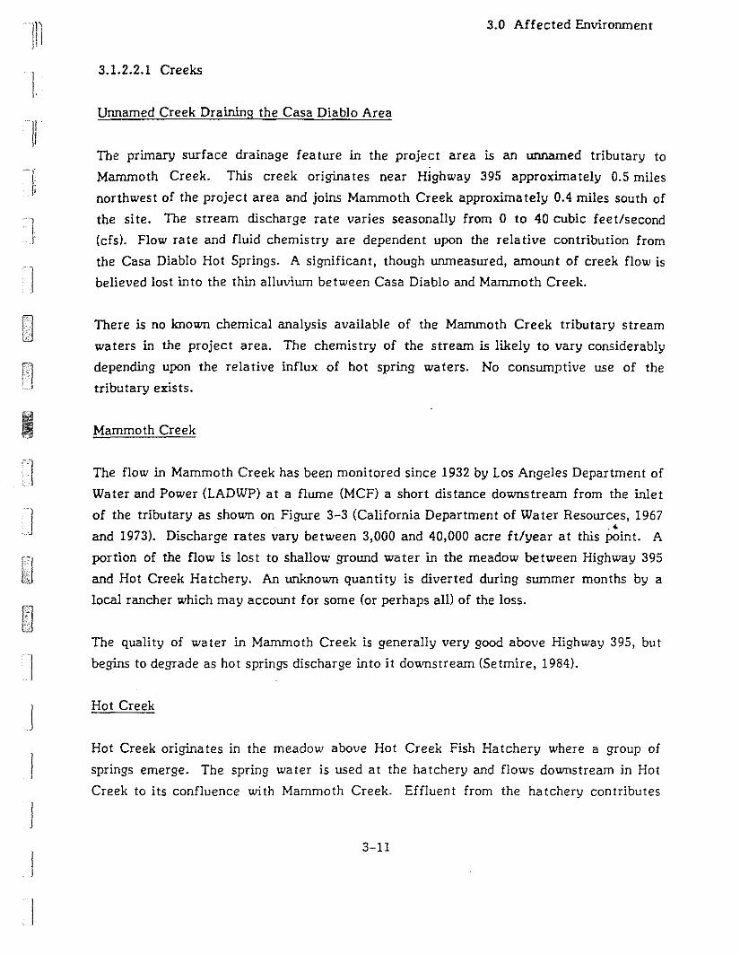
III·
I,
Ij
3.0 Affected Environment
3.1.2.2.1 Creeks
Unnamed Creek Draining the Casa Diablo Area
The primary surface drainage feature in the project area is an unnamed tributary to
Mammoth Creek. This creek originates near Highway 395 approximately 0.5 miles
northwest of the project area and joins Mammoth Creek approximately 0.4 miles south of
the site. The stream discharge rate varies seasonally from 0 to 40 cubic feet/second
(cfs). Flow rate and fluid chemistry are dependent upon the relative contribution from
the Casa Diabio Hot Springs. A significant, though unmeasured, amount of creek flow is
believed lost into the thin alluvium between Casa Diablo and Mammoth Creek.
There is no known chemical analysis available of the Mammoth Creek tributary stream
waters in the project area. The chemistry of the stream is likely to vary considerably
depending upon the relative influx of hot spring waters. No consumptive use of the
tributary exists.
I Mammoth Creek
The flow in Mammoth Creek has been monitored since 1932 by Los Angeles Department of
Water and Power (LADWP) at a flume (MCF) a short distance downstream from the inlet
of the tributary as shown on Figure 3-3 (California Department of Water Resources, 1967.<
and 1973). Discharge rates vary between 3,000 and 40,000 acre ft/year at this point. A
portion of the flow is lost to shallow ground water in the meadow between Highway 395
and Hot Creek Hatchery. An unknown quantity is diverted during summer months by a
local rancher which may account for some (or perhaps all) of the loss.
The quality of water in Mammoth Creek is generally very good above Highway 395, but
begins to degrade as hot springs discharge into it downstream (Setmire, 1984).
j
j
j
Ij
Hot Creek
Hot Creek originates in the meadow above Hot Creek Fish Hatchery where a group of
springs emerge. The spring water is used at the hatchery and flows downstream in Hot
Creek to its confluence with Mammoth Creek. Effluent from the hatchery contributes
3-11
3.0 Affected Envirorunent
approximately 36 cfs to the flow of Hot Creek. This figure was obtained from
measurements of flow rate at the springs. Actual flow rates may be higher if there are
surface drainage contributions to the creek (Sorey, 1976; Farrar, 1985).
Hot Creek is monitored at the flume (HCF) below Hot Creek Gorge. This site has been
used to gauge stream flow since 1923 and has most re::ently been used to collect data on
the rate of discharge from the springs in Hot Creek Gorge relative to total stream flow.
Stream flow at this flume varies between 25,000 and 80,000 acre ft/year and averages
approximately 40,000 acre ft/year (California Dept. of Water Resources, 1967>. Of this
total, 7,000 acre ft/year (average 9.5 cfs) are contributed by hot springs along the gorge
(Farrar, 1985).
Chemical analyses of samples taken at HCF indicate that most of the dissolved mineral
load is due to discharge from thermal springs along Mammoth and Hot Creeks (California
Department of Water Resources, 1967, 1973; Setmire, 1984). Under the present
conditions, the water in Hot Creek at this point (HCF) has some contamination and may
not be recommended for human consumption (Setmire, 1984).
3.1.2.2.2 Thermal Springs
Numerous hydrothermal features are found from the Casa Diablo area to the Hot Creek
Gorge area (see Figure 3-3). These consist of springs of various temperatures and.'discharge rates and gas-emitting fumaroles. Some of these features maintain a relatively
constant level of activity from year to year; others are intermittent and may change or
disappear entirely.
Casa Diablo
There are several surface thermal features in the Casa Diablo area. The most prominent
is the Casa Diablo Geyser (CDG), located immediately northwest of the MP I plant. The
operators of MP I have cooperated with the monitoring of the springs and fumaroles by
the U.S. Geological Survey (Farrar et a!., 1985; Farrar et a!., 1986). The results thus far
show a distinct correlation between spring discharge and tectonic strain events, as shown
by a large increase in flow rate three weeks before a nearby November 1984 earthquake
of magnitude 5.8. Historical observations which date back to the late 1800s report a wide
3-12
]
I
J
I
'11"\
II i
/1
Ii
'1
3.0 Affected Environment
range of activity from "geysering" tens of feet high to no visible discharge (Lawrence
Berkeley Laboratory, 1984). Estimates of total spring discharge vary from 0.35 to 1.4 cfs
with most of the flow from the main vent (COG). The temperature measurements range
from 80°C to 90°C; the springs with low flow rates have lower temperatures than the
springs which have higher flow rates. Some correlation is shown between existing
geothermal well production/injection and the total discharge at COG and two lesser
springs. However, the historically variable flow at Casa Diablo makes the correlation
difficult to quantify. When production at MPl began, the flow at COG decreased some
and briefly during Fall 1985, when production at MPI was interrupted, the geyser flow
increased. The general trend over the past 2 1/2 years has been decreasing spring flow at
Casa Diablo. In April 1987 COG ceased to flow (Sorey, 1987b).
Hot spring fluids are characterized as sodium bicarbona te-chloride waters wi th a total
dissolved solids content of 1000 to 1400 mg/l. The alkalinity of the COG (382 to 469 mg/!)
is between the alkalinity of the springs supplying Hot Creek Hatchery (70 to 110 mglI),
and the geysers at Hot Creek Gorge (471 to 490 mg/l). The data indicate that the
chemistry of each spring is affected by discharge rate and temperature. Boiling near or
on the surface concentrates constituents in the fluid, which may then partialIy re-mix
with the condensate" Published analyses also indicate a complex relationship with possible
mixing of cooler, less saline, shalIow groundwaters (Mariner and Wiley, 1976).
I-/
J Colton Spring Area"
There are three groups of small springs located in the Colton Spring vicinity
approximately one mile southeast of Casa Diablo along Mammoth Creek (see Figure 3-3).
Their combined discharge is small and though there is no consumptive use, the discharge is
now continuously monitored. The three springs differ markedly from each other in
temperature and chemical composition and are of interest as indicators of the local
hydrothermal system. Colton Spring (CS) is similar to COG with respect to temperature
and chemical species. Meadow Spring (MS) is cooler with low, intermittent discharge;
chloride content and ionic ratios indicate that it could result from the mixing of water
similar to COG and local, near-surface groundwa ter. Chance Spring (CHS) is stilI cooler
and has relatively high discharge. Its composition is closer to meteoric water than the
other springs, suggesting a minor thermal water component.
3-13
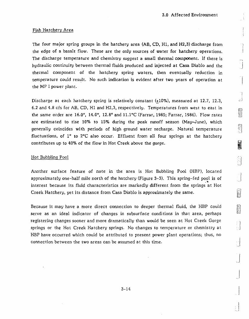
3.0 Affected Envirorunent
Fish Hatchery Area
The four major spring groups in the hatchery area (AB, CD, HI, and H2,3) discharge from
the edge of a basalt flow. These are the only sources of water for hatchery operations.
The discharge temperature and chemistry suggest a small thermal component. If there is
hydraulic continuity between thermal fluids produced and injected at Casa Diablo and the
thermal component of the hatchery spring waters, then eventually reduction in
temperature could result. No such indication is evident after two years of operation at
the MP I power plant.
Discharge at each hatchery spring is relatively constant (±10%), measured at 12.7, 12.3,
6.2 and 4.8 cfs for AB, CD, HI and H2,3, respectively. Temperatures from west to east in
the same order are 16.0°, 14.0°, 12.8° and 1l.loC (Farrar, 1985; Farrar, 1986). Flow rates
are estimated to rise 10% to 15% during the peak runoff season (May-June), which
generally coincides with periods of high ground water recharge. Natural temperature
fluctuations, of 1° to 2°C also occur. Effluent from all four springs at the hatchery
contributes up to 40% of the flow in Hot Creek above the gorge.
Hot Bubbling Pool
Another surface feature of note in the area is Hot Bubbling Pool (HBP), located
approximately one-half mile north of the hatchery (Figure 3-3). This spring-fed pool is of:-
interest because its fluid characteristics are markediy different from the springs at Hot
Creek Hatchery, yet its distance from Casa Diablo is approximately the same.
Because it may have a more direct connection to deeper thermal fluid, the HBP could
serve as an ideal indicator of changes in subsurface conditions in that area, perhaps
registering changes sooner and more dramatically than would be seen at Hot Creek Gorge
springs or the Hot Creek Hatchery springs. No changes to temperature or chemistry at
HBP have occurred which could be attributed to present power plant operations; thus, no
connection between the two areas can be assumed at this time.
3-14
]
1
I
I
J
I
j
]

Ii
11
]i
]
J
J
JJ
3.0 Affected Environment
Hot Creek Gorge Springs
Several springs discharge at varying rates along Hot Creek Gorge (HC-2 and HC-l,3).
Temperatures vary from 73° to 94°C. Total spring flow from this area cannot be
measured directly since the major contributing vents are submerged in the creek bed.
However, a close estimate of flow rate can be made from chemical flux correlations using
the total flow of Hot Creek and its chemical load, measured at the USGS maintained
flume (HCF) below the gorge (Farrar, 1985; Eccles, 1976; Sorey & Clark, 1981). Such
calculations have yielded an average for total Hot Creek spring discharge of 9.5 cfs with a
high of 11.6 cfs in 1980, attributed to recent seismic activity at that time. Increases in
total flow, apparently due to tectonic strain, appear suddenly and slowly die off returning
to normal flow patterns. The major vents are similar in chemical composition. The ionic
compositions and ratios are comparable to the HEP and COG, but the isotope ratios show
significant differences. No changes in temperature, flow rate or chemistry have been
seen in the Hot Creek Gorge springs as a result of the current MP I power plant operations.
3.1.2.3 Subsurface Resources
Drilling and geophysical studies in the Long Valley caldera have confirmed the presence of
thermal fluids at various depths and locations in the south and southwest areas, including
the Casa Diablo area and the project site. Deep drilling has been conducted at the lnyo
Craters at the western edge and to east of the Hot Creek Gorge. The. p.ighest
temperatures are found at Shady Rest (400°F) and Casa Diablo (350°F). Subsurface
temperatures, depths, and water chemistry are summarized in the following discussion.
Figure 3-4 is an idealized cross-section (along line A-A'-An in Figure 3-3) showing the
relative locations of geologic units, faults, and selected wells from Shady Rest to Hot
Creek Gorge.
Subsurface hydrologic resources in the Casa Diablo area are characterized by a shallow
localized cold groundwater at zero to 40 ft. depth, underlain by the main geothermal
production zone at a depth of 300 to 600 feet with temperatures of approximately 330 0 to
350°F. A second thermal zone is found at a depth of 2,000 to 2,600 ft. (with temperatures
about 305°F). The highest temperatures are found within the fractured rhyolite complex
named the Early Rhyolite, located between zero and 1,500 feet in this area. The base of
3-15
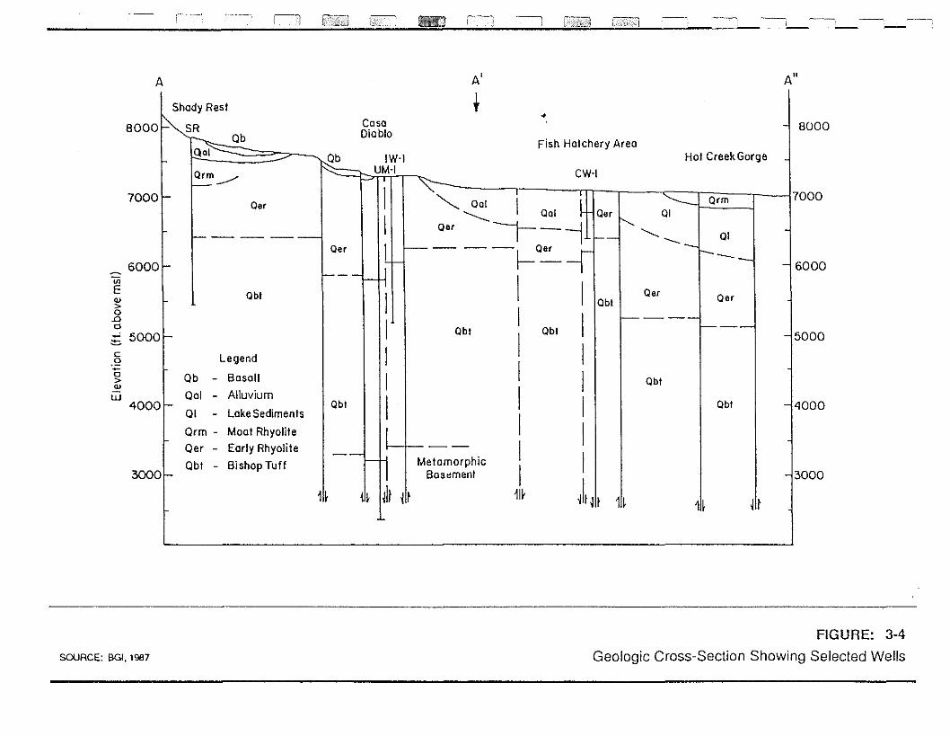
c--~ ~
~,
AU
-15000
-13000
7000
--14000
-l 8000
--16000
j!t
Oar
Obt
1!~
Hot Creek Gorge
ObI
Oar
•
Fish Hatchery Area
+A'
ObI
MetamorphicBosoment
CW-I
arm~ I 01
~ Oal I oal Oar '-... -+- 01---........ -J-- - --l _Oar I I _
- Oar\---- - 1--
I I lObI
lObI II II II II II I
1!f )1 j II 1!~
CosoDiablo
ObI
" IW·IUM-I
11f
Oar
obt
arm1--.-/
Legend
Ob - Basalt
001 - Alluvium
01 - Lake Sediments
Orm - Moat Rhyolite
Oer - Early Rhyolite
Obt - Bishop Tuff
60001-
I-
70001-
30001-
A
onEQ)
>o.0o~ 5000~c.2a>Q)
W4000~
SOURCE: 00. 1987
FIGURE: 3-4
Geologic Cross-Section Showing Selected Wells
lJ
3.0 Affected Environment
the Early Rhyolite also contains the cooler zone separating the upper and lower thermal
aquifers. The Bishop Tuff is below the Early Rhyolite at an approximate depth of 1,500 to
4,100 ft. in the Casa Diablo area. This formation contains a second high temperature
zone. Temperatures decrease steadily below this zone (Figure 3-4, Well OM-I). Well
OM-I has penetrated through the Bishop Tuff to the basement complex.
The major faults bounding the Casa Diablo area have apparently allowed the hot fluids to
circulate closer to the surface than at other areas of the caldera. Higher temperatures
are found in the Shady Rest well, but at greater depth than at Casa Diablo.
A recently drilled well (SF 35-32; see Figure 2-2) showed that higher static pressures are
found south of the existing MP I wells in the area of the proposed PLES I development.
Pump testing at rates of up to 2,100 gpm showed higher productivity than in the existing
MP I production wells with a small pressure drop in SF 35-32 and no measurable
interference with existing wells (Mesquite, 1986). Chemistry and temperature data
suggest tha t the new well is producing from the same reservoir as the MP I wells.
3.1.2.4 Summary of Hydrologic Data
3.1.2.4.1 Pressure Data
Pressure measurements in wells currently used for production at Casa Diablo do not.'
appear to be accurate enough for the de tection of small scale trends. A proposal is
currently under consideration to greatly improve the quality of such data (PLES, 1987).
Although the well test done at SF 35-32 (see Figure 2-2) is useful, data from other well
tests do not allow analysis of small scale effects and do not provide reservoir parameters
for calculations in this case. Therefore, pressure data presently cannot be used to
evaluate the models.
3.1.2.4.2 Temperature Data
Temperature data from wells in the Casa Diablo area show a localized high temperature
zone in the production interval at Casa Diablo. An isothermal zone exists at depths of
about 1,000 feet in the Shady Rest well, and warm zones similar to those at Casa Diablo
3-17
3.0 Affected Envirorunent
are found near the hatchery and Hot Creek Gorge. It is possible that fluid could be
flowing laterally from Shady Rest through the Casa Diablo area to the Hot Creek Gorge
area, cooling along the way. The assumption of the Lateral Flow Model would require
fluids to move through or around major faults at Casa Diablo and across faul t and
stratigraphic boundaries toward Hot Creek Gorge. Such a path may be difficult to
envision from the idealized cross-section of Figure 3-4. The extent of fracturing in the)
stratigraphic units would significantly influence fluid movement.
IAn alternative interpretation based on the Upwelling/Fracture Flow Model is that Casa
Diablo and Hot Creek are recharged by upwelling fluids from different major faults.
Surface infiltration into the alluvial layer (Qal) could explain the low temperature in
well M-S.
Therefore, temperature data cannot be used to differentiate between the Lateral Flow
Model and the Upwelling/Fracture Flow Model.
•
3.1.2.4.3 Chemical Da ta
Chemical analyses may be used to suggest the source of spring waters based on the
.- characteristics of the discharge and subsurface water. These efforts at correlation have
been based on comparison of prominent chemical s!,~cies tha t are conserved during mixing
and boiling, such as: chloride (CI), lithium (Li), and boron (B) (see Table 3-3).
CIIB and CIILi ratios indicate that the ionic ratios in various spring waters are
comparable between the different thermal spring areas. The data also shows a trend of
decreasing ionic concentration away from Casa Diablo, but with ionic ratios preserved
(Shevenell, et aI., in press). These data have been used to suppo~t the Lateral Flow Model
describing a single source of fluids for the springs at Casa Diablo, Hot Creek Gorge, and
Hot Creek Hatchery.
The stable isotope data for the same springs show large differences between the Casa
Diablo springs, deep wells, and CDG. This suggests a more complex thermal fluid
chemistry than is allowed by simply assuming dilution of thermal waters with non-thermal
fluids. A combination of boiling and mixing of thermal and non-thermal fluids has been
used to accoun1 . Jr the isotopic data. These results were then used to support the Lateral
3-18
I
j
IJ
j
J
Ii
11
l-11
]
j
3.0 Affected Environment
Flow Model based on a single fluid source. A simpler explanation has been proposed based
on a multiple-source model, the Upwelling/Fracture Flow Model. The multiple fluid
source model attributes differences in fluid chemistry between the thermally active areas
to each having a different source of fluid that is upwelling from great depth.
At Casa Diablo, the chemistry of the reservoir fluids and the chemistry of the Casa
Diablo springs, such as CDG are similar. In particular, the analyses of ionic ratios and
stable isotope groups (regardless of the suggested degree of mixing by cold near-surface
groundwater) show close agreement between data from the producing reservoir and
surface springs. A preliminary analysis of fluid from the Shady Rest well also indicates a
composition very similar to that of the Casa Diablo wells, but with a far higher calcium
concentration, possibly due to the abundant calcium-rich deposits in fractures observed in
the core samples. Differences in fluid chemistry of surface hydrothermal fea tures
eastward of Casa Diablo have been explained by a combina tion of boiling of geothermal
fluids and mixing with water of meteoric composition (Sorey, 1987). There are
exceptions; for example, the composition of fluids from the Hatchery Area Well CW
requires mixing and boiling fractions that are different from the other wells to account
for its ionic composi tion.
Currently, chemical data collected for several years from springs, and more recently from
wells, can be used to support either of the current hydrothermal models to some extent .
..3.1.2.5 Informa tion Needed to Evalua te the Models
Overall, the proposed models of the hydrothermal system represent different views of
fluid origin and movement of fluids in the southwest caldera region. Each has
implications for the effect of future development at Casa Diablo on springs at Hot Creek
Gorge and Hot Creek Hatchery. Currently, the chemistry, temperature, and pressure data
do not provide definitive support for any of the models thus far proposed.
If it were not for the prohibitive cost and potential environmental impacts, many
scientists working in the area probably would have extended their studies to allow more
data to be collected which could result in a better understanding of the hydrothermal
system. A list of research projects which may add to the data base could include:
3-19
3.0 Affected Envirorunent
numerous core holes, stepping outward in several directions from Casa Diablo,
completed to allow flow testing, sampling, temperature measurements and pressure
moni toring;
concrete containment structures for all springs to allow continuous and potentially
more accurate measurement of spring flow and temperature; and
detailed geophysical surveys in the south caldera region to focus on near surface (0 to
2,000 feet deep) fluid flow and geologic structure.
At present, there are envirorunental, financial, and technical constraints to pursuing these
studies, so it is uniikely that a definitive model of the Long Valley caldera system will be
forthcoming.
3.1.3 NOISE
3.1.3.1 Regulatory Framework
The Noise Element of the Mono County General Plan identifies goals and policies to attain
and maintain acceptable noise levels. The Element requires an acoustical analysis prior to
construction of any noise-sensitive land uses in areas that are currently exposed to a
day-night equivalent noise levels (Ldn) of 60 dBA or more.ll,21 In addition, the Element
requires an acoustic analysis for projects that would generate high noise levels in areas
where existing noise levels are less than 60 dBA, Ldn
(Mono County, 1981a). The Element
also contains recommendations for mitigating noise, for new noise sources that exceed
community noise compatibili ty guidelines.
Mono County Ordinance 79-479 limits construction and grading activi ties u6 thin 500 feet
of residential or commercial occupancies to between 7:00 a.m. and 8:00 p.m. daily with
Sunday construction activity allowed from 9:00 a.m. to 5:00 p.m. This ordinance is
enforced by the Mono County Sheriff.
The U.S. Geological Survey, Conservation Division, has issued seven Geothermal
Resources Operational (GRO) Orders. These operational orders have been adopted into
3-20
I
I
]
'1I, :
11
-Ji"
Ij
1
-'-'
3.0 Affected Environment
federal regulation and pertain to all lessees on federal lands. Although these Orders are
not specifically relevant to the MP II & ITl projects due to their proposed siting on private
land, its guidelines may be used by local authorities to assess project impacts in lieu of
more specific or timely local guidelines (Lyster, 19B7b). GRO Order 4 calls for noise to
be measured according to specific procedures with equipment that meets certain
performance specifica tions. Attenua tion of objectionable noise wi th muffling devices is
also recommended. Under GRO Order 4, the lessee must comply with federal
occupational noise exposure levels or State standards for protection of personnel,
whichever is the most restrictive. Unless a more restrictive level is set by the authorized
officer, the maximum noise exposure levels are set at an energy-equivalent noise level
(L ) of 65 dBA for all geothermal-related activity as measured at the lease boundary oreq
at O.B kilometers, whichever is greater (U.S. Geological Survey, Conservation Division,
1976).131
3.1.3.2 Noise Sources and Levels
Twenty-four-hour average noise levels were measured on the project site between the Bth
and 11 th of January 19B7 (see Table 3-4). The major noise source in the project area is
the MP I geothermal power plant located about BOO feet southwest of the proposed MP III
site.
Operation of the MP I plant produces a continuous high--:level hum which hai been
measured in excess of 100 dBA, L within the facility compound. The 7B dBA, Looeqmeasured 150 feet from the plant during the January site visit (see Table 3-4) could
causes a potential hearing loss hazard to those continuously exposed without hearing
protection. Major sources of noise from the plant include the expander turbines, the
air-cooled condenser fans, and the piping between the expanders and condensers. Noise
control retrofitting of the MP I plant reduced noise levels by 10 to 12 dBA, Leq. The
muffling devices were subsequently removed, however, apparently due to faulty
construction. A redesigned system with similar noise reduction potential will be installed
at a later date. There have been complaints reported to the Energy Management
Department about noise from the MP I plant (Lyster, 19B7c).
Vehicular noise in the project area is negligible. Hot Springs Road, which passes to the
southwest of the project area, is lightly traveled (no traffic counts have been taken since
plant construction). The closest heavily traveled road is Highway 395, approxima tely
3-21
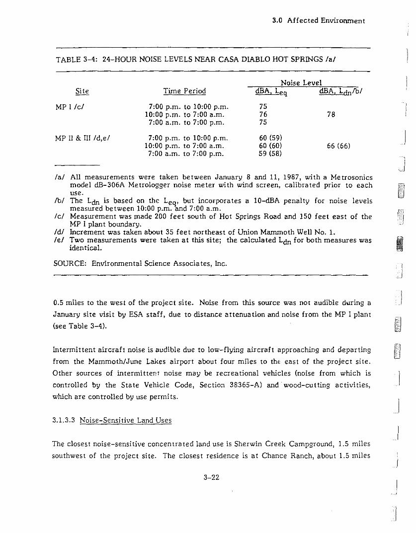
3.0 Affected Environment
TABLE 3-4: 24-HOUR NOISE LEVELS NEAR CASA DIABLO HOT SPRINGS lal
Noise Level
66 (66)
MP I lei
MP Il & III Id,el
Time Period
7:00 p.m. to 10:00 p.m.10:00 p.m. to 7:00 a.m.
7:00 a.m. to 7:00 p.m.
7:00 p.m. to 10:00 p.m.10:00 p.m. to 7:00 a.m.7:00 a.m. to 7:00 p.m.
dBA, Leq dBA, Ldnfbl
7576 7875
60 (59)60 (60)59 (58)
I
lal All measurements were taken between January 8 and 11, 1987, with a Metrosonicsmodel dB-306A Metrologger noise meter with wind screen, calibrated prior to eachuse.
fbi The Loo is based on the Leq, but incorporates a 10-dBA penalty for noise levelsmeasured between 10:00 p.m. and 7:00 a.m.
lei Measurement was made 200 feet south of Hot Springs Road and 150 feet east of theMP I plant boLUldary.
Idl Increment was taken about 35 feet northeast of Union Mammoth Well No.1.lei Two measurements were taken at this site; the calculated Loo for both measures was III.
identical. III
SOURCE: Environmental Science Associates, Inc.
0.5 miles to the west of the project site. Noise from this source was not audible during a
January site visit by ESA staff, due to distance attenuation and noise from the MP I plant
(see Table 3-4).
Intermittent aircraft noise is audible due to low-flying aircraft approaching and departing
from the Mammoth/JLUle Lakes airport about four miles to thE east of the project site.
Other sources of intermittent noise may be recreational vehicles (noise from which is
controlled by the State Vehicle Code, Section 38365-A) and wood-cutting activities,
which are controlled by use permits.
3.1.3.3 Noise-Sensitive Land Uses
The closest noise-sensitive concentrated land use is Sherwin Creek Campground, 1.5 miles
southwest of the project site. The closest residence is at Chance Ranch, about 1.5 miles
3-22
IJ
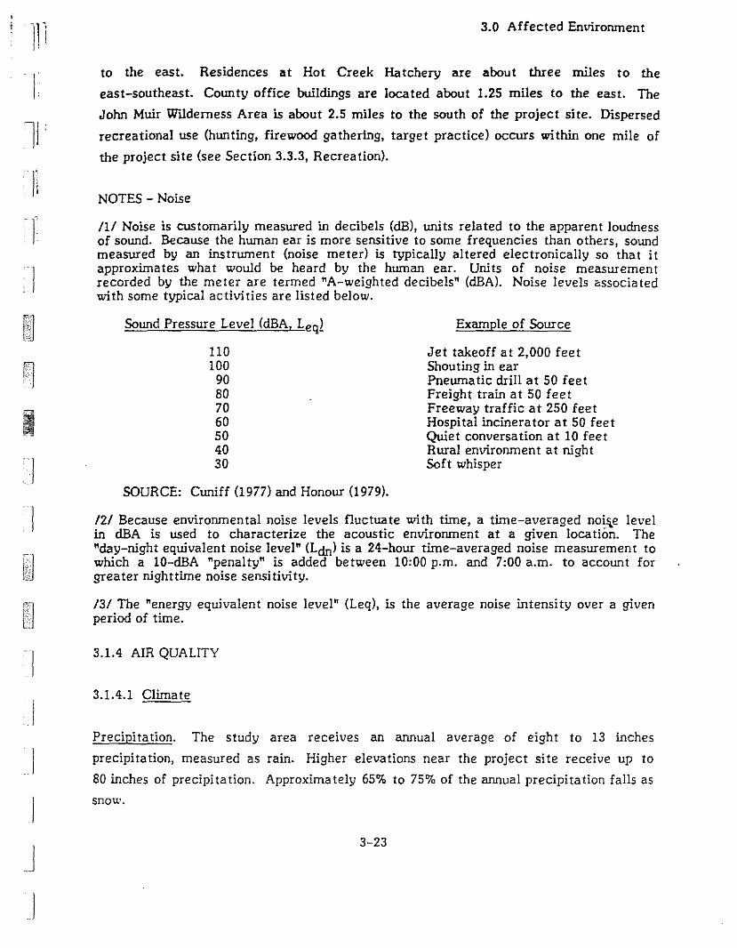
'1Ii)
'1 ' .I
Ii
f
3.0 Affected Environment
to the east. Residences at Hot Creek Hatchery are about three miles to the
east-southeast. County office buildings are located about 1.25 miles to the east. The
John Muir Wl.1derness Area is about 2.5 miles to the south of the project site. Dispersed
recreational use (hunting, firewood gathering, target practice) occurs within one mile of
the project site (see Section 3.3.3, Recrea tion).
NOTES - Noise
III Noise is customarily measured in decibels (dB), units related to the apparent loudnessof sound. Because the human ear is more sensitive to some frequencies than others, soundmeasured by an instrument (noise meter) is typically altered electronically so that itapproxima tes wha t would be heard by the human ear. Uni ts of noise measuremen trecorded by the meter are termed "A-weighted decibels" (dBA). Noise levels associatedwith some typical activities are listed below.
/21 Because environmental noise levels fluctuate with time, a time-averaged noi~e levelin dBA is used to characterize the acoustic environment at a given location. The"day-night equivalent noise level" (Ldn) is a 24-hour time-averaged noise measurement towhich a 10-dBA "penalty" is added between 10:00 p.m. and 7:00 a.m. to account forgreater nighttime noise sensitivity.
131 The "energy equivalent noise level" (Leq), is the average noise intensity over a givenperiod of time.
I1
J
Sound Pressure Level (dBA, Leql
110100
90807060504030
SOURCE: Cuniff (1977) and Honour (1979).
Example of Source
Jet takeoff at 2,000 feetShouting in earPneumatic drill at 50 feetFreight train at 50 feetFreeway traffic at 250 feetHospital incinerator at 50 feetQuiet conversation at 10 feetRural environment at nightSoft whisper
IIJ
. J
J
3.1.4 AIR QUALITY
3.1.4.1 Climate
Precipitation. The study area receives an annual average of eight to 13 inches
precipitation, measured as rain. Higher elevations near the project site receive up to
80 inches of precipitation. Approximately 65% to 75% of the annual precipitation falls as
snow.
3-23
3.0 Affected Environment
The Pacific High, a persistent weather system located off the coast of California,
strongly influences regional weather. In the surruner, it deflects the westerly movement
of storm tracks to the north, which results in mild dry weather at the project site. When
the pressure system moves south in the winter, westerly storms can move across the
state. These storms typically carry moisture-laden air up the Sierra Nevada and produce
heavy snowfalls.
Temperature. Summer daytime temperatures range from 65° to 90°F. Nighttime ]
temperatures range from 37° to 55°F. Winter daytime temperatures average 25°F, with
nighttime lows dropping as low as -20°F.
Wind. In the summer, when the Pacific High prevents westerly storm tracks from
reaching the Sierra Nevada, wind patterns are determined primarily by local topography.
Temperature differences between warm valley floors and cooler upper slopes create
upslope daytime winds and downslope evening breezes tha t can reach five to 10 miles per
hour (mph). During occasional thunderstorms, winds are from the south and southeast. In
the winter, wind patterns are due primarily to storm systems moving through from the Iwest. Wind speeds typically reach 10 to 20 mph, with gusts from 40 to 70 mph.
Temperature Inversions. When air temperature increases with height, vertical mixing and
dispersion of pollutants is inhibited. The mixing height is the level to which pollutants can
be dispersed in the atmosphere; typically this is the height of the base of the inversion
layer. Estimated daily mixing heights for the study area, derived by Holzworth (1972), are
shown in Table 3-5. These heights indicate that the area is moderately prone to
inversion-related pollutant concentrations, with the lowest mixing heights occurring on
autumn mornings.
3.1.4.2 Existing Air Qualitv
The project site is wi thin the Great Basin Valleys Air Basin (Alpine, Mono, and lnyo
Counties), which is administered by the Great Basin Unified Air Pollution Control District
(GBUAPCD). Air quality in the project area has been monitored by the GBUAPCD in
cooperation with the California Air Resources Board (ARB), since 1979. Four criteria
pollutants (those for which the U.S. Environmental Protection Agency has established
ambient air quality standards) have been monitored in the Mammoth Lakes area: total
3-24
j
J
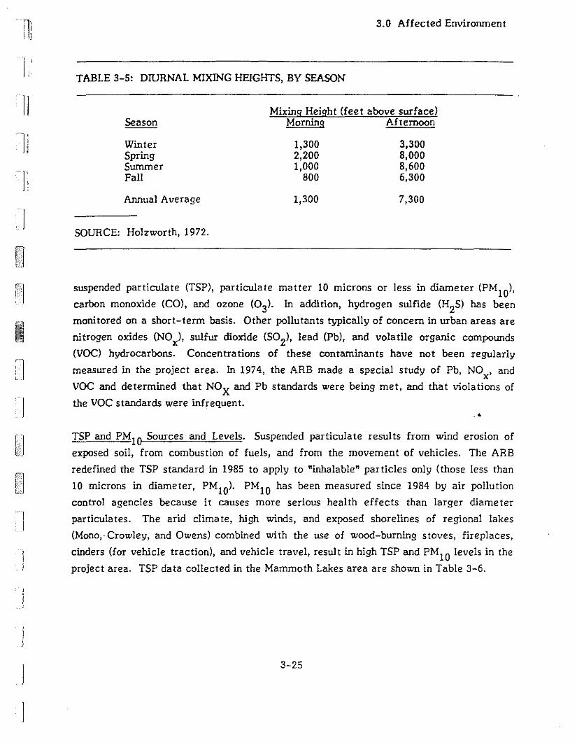
III
1
3.0 Affected Environment
TABLE 3-5: DIURNAL MIXING HEIGHTS, BY SEASON
II
IJ
T
Season
WinterSpringSummerFall
Annual Average
SOURCE: Holzworth, 1972.
Mixing Height (feet above surface)Morning Afternoon
1,300 3,3002,200 8,0001,000 8,600
800 6,300
1,300 7,300
]
i. J
I
suspended particulate (TSP), particulate matter 10 microns or less in diameter (PM1O
),
carbon monoxide (CO), and ozone (03)' In addition, hydrogen sulfide (H2S) has been
monitored on a short-term basis. Other pollutants typically of concern in urban areas are
nitrogen oxides (NOx)' sulfur dioxide (502)' lead (Pb), and volatile organic compounds
(VOC) hydrocarbons. Concentrations of these contaminants have not been regularly
measured in the project area. In 1974, the ARB made a special study of Pb, NO , andx
VOC and determined that NOX and Pb standards were being met, and that violations of
the VOC standards were infrequent..4
TSP and PM10 Sources and Levels. Suspended particula te resul ts from wind erosion of
exposed soil, from combustion of fuels, and from the movement of vehicles. The ARB
redefined the TSP standard in 1985 to apply to "inhalable" particles only (those less than
10 microns in diameter, PMlO ). PM10 has been measured since 1984 by air pollution
control agencies because it causes more serious health effects than larger diameter
particulates. The arid climate, high winds, and exposed shorelines of regional lakes
(Mono,· Crowley, and Owens) combined with the use of wood-burning stoves, fireplaces,
cinders (for vehicle traction), and vehicle travel, result in high TSP and PM10 levels in the
project area. TSP da ta collected in the Mammoth Lakes area are shown in Table 3-6.
3-25
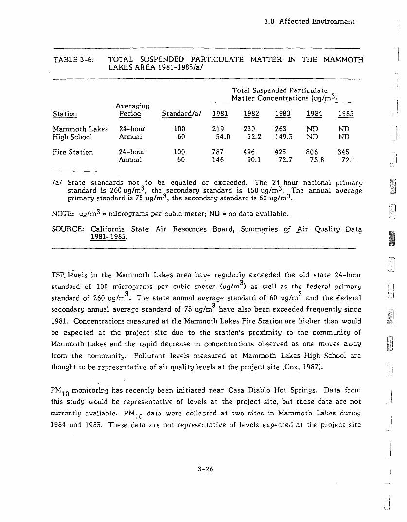
TABLE 3-6:
3.0 Affected Envirorunent
TOTAL SUSPENDED PARTICULATE MATTER IN THE MAMMOTHLAKES AREA 1981-1985/a/
Total Suspended ParticulateMatter Concentrations (ug/m3_,_
AveragingStation Period Standard/at 1981 1982 1983 1984 1985
Marrunoth Lakes 24-hour 100 219 230 263 ND NDHigh School Annual 60 54.0 52.2 149.5 ND ND
Fire Sta tion 24-hour 100 787 496 425 806 345Annual 60 146 90.1 72.7 73.8 72.1
/a/ State standards not to be equaled or exceeded. The 24-hour national primarystandard is 260 ug/m3, the secondary standard is 150 ug/m3. The annual averageprimary standard is 75 ug/m3, the secondary standard is 60 ug/m 3.
NOTE: ug/m3 =micrograms per cubic meter; ND =no data available.
SOURCE: California State Air Resources Board, Summaries of Air Quality Data iii...1981-1985. 1II
TSP, levels in the Mammoth Lakes area have regularly exceeded the old state 24-hour
standard of 100 micrograms per cubic m~ter (ug/m3) as well as the federal primary
standard of 260 ug/m3. The state annual average standard of 60 ug/m3 and the <federal
secondary annual average standard of 75 ug/m3 have also been exceeded frequently since
1981. Concentrations measured at the Mammoth Lakes Fire Station are higher than would
be expected at the project site due to the station's proximity to the community of
Mammoth Lakes and the rapid decrease in concentrations observed as one moves away
from the community. Poliutant levels measured at Mammoth Lakes High School are
thought to be representative of air quality levels at the project site (Cox, 1987).
PMI0 monitoring has recently been initiated near Casa Diablo Hot Springs. Data from
this study would be representative of levels at the project site, but these data are not
currently available. PM I0 data were collected at two sites in Mammoth Lakes during
1984 and 1985. These data are not representative of levels expected at the project site
3-26
J
I, )
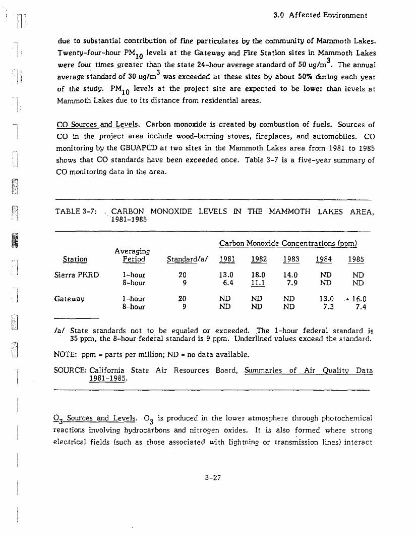
Ili
l.
3.0 Affected Environment
due to substantial contribution of fine particulates by the community of Mammoth Lakes.
Twenty-four-hour PMI0 levels at the Gateway and Fire Station sites in Mammoth Lakes
were four times greater than the state 24-hour average standard of 50 ugfm3• The annual
average standard of 30 ugfm3 was exceeded at these sites by about 50% during each year
of the study. PMlO levels at the project site are expected to be lower than levels at
Mammoth Lakes due to its distance from residential areas.
CO Sources and Levels. Carbon monoxide is created by combustion of fuels. Sources of
CO in the project area include wood-burning stoves, fireplaces, and automobiles. CO
monitoring by the GBUAPCD at two sites in the Mammoth Lakes area from 1981 to 1985
shows that CO standards have been exceeded once. Table 3-7 is a five-year summary of
CO monitoring data in the area.
TABLE 3-7: CARBON MONOXIDE LEVELS IN TIiE MAMMOTH LAKES AREA,1981-1985
Carbon Monoxide Concentrations (ppm)Averaging
Station Period Standard!a! 1981 1982 1983 1984 1985
Sierra PKRD I-hour 20 13.0 18.0 14.0 NO ND8-hour 9 6.4 11.1 7.9 NO NO
Gateway I-hour 20 NO NO ND 13.0 .' 16.08-hour 9 NO NO NO 7.3 7.4
fa! State standards not to be equaled or exceeded..The I-hour federal standard is. 35 ppm, the 8-hour federal standard is 9 ppm. Underlined values exceed the standard.
NOTE: ppm = parts per million; NO = no data available.
SOURCE: California State Air Resources Board, Summaries of Air Quality Data1981-1985.
0 3 Sources and Levels. 0 3 is produced in the lower atmosphere through photochemical
reactions involving hydrocarbons and nitrogen oxides. It is also formed where strong
electrical fields (such as those associated with lightning or transmission lines) interact
3-27
3.0 Affected Environment
with air. The primary source of 03 precursors in the project area is NOx and VOC
emissions from motor vehicles.
03 monitoring near Mammoth Lakes between 1981 and 1985 recorded one incidence of 03
levels equal to the state standard of 0.10 ppm in 1985. Prior to that, the highest one-hour
average for each year was reported to be 0.09 ppm.
HZS Source and Levels. HZS is a colorless, transparent, poisonous gas with a rotten-egg
odor. lts danger to individuals depends on its concentration and the duration of exposure.
The odor is detectable by humans at concentrations between one and ZO ppm.
Concentrations between 50 and 500 ppm irritate the eyes and the upper respiratory track.
At concentrations over 700 ppm, the gas can be lethal (Stellman and Daum, 1973).
I)
Geothermal springs are the main source of HZS in the project area. Although traces of
HZS gas are found in stearn released by the springs, data obtained by the APCD from 198Z
through 1984 showed generally low background concentrations of HZS in the area. Tne
state one-hour standard of 0.03 ppm for HZS was equaled on three occasions between
January 198Z and January 1985. The APCD currently limits HZS emissions from Igeothermal wells to Z.5 kglhr/well (5.51blhr/welll. According to the GBUAPCD, there
have been no reported accidental releases of HZS from the MP I geothermal plant and
there have been no odor complaints or permit violations (Cox, 1987).
isobutane Source and Levels. lsobutane is a colorless fluid which is shipped under pcessure
as a liquid. At atmospheric pressure and 15°C, it is a gas. The vapor is flammable at
concentrations of 1.8 to 8.4% in air. At low concentrations it is odorless, but at higher
concentrations it has a gasoline-like odor. It is used as the working fluid in tLe existing
MP I power plant, where operating losses of Z50 to 1000 Ibs/day have occurred during 1987
(Walker, 1987). In 1974, there were 60,000 Ibs/day of isobutane released in the State of
California (Grosjean and Fung, 1984). Since 1974 isobutane has been introduced as a
substitute for fJourocarbons as a propellant for aersol sprays, so the state-wide emissions
are likely to be much higher now. The emission rates published by the California Air
Resources Board (ARB) lump isobutane with other volatile hydrocarbons, so the amount of
isobutane is not readily available from published sources.
I
3-28
I ll II iI
I;
rI'I:
r
]
3.0 Affected Envirornnent
Isobutane can react photochemically to form air pollutants. On a scale from very
reactive to non-reactive, isobutane is ranked as a modera tely reactive compound
(Atkinson, 1987; Maxwell, 1987; Allen, 1987). Reactive hydrocarbons can be ranked by
comparing their rate constants (the rate at which a reaction between the hydrocarbon and
other substances occurs). The ARB ranks reactive hydrocarbons according to a rate
constant given in the units (I/ppm/min). The rate constant for isobutane in these units is
3,503. This level is moderately low relative to etylene at 12,600; propylene at 39,000; and
ethyl butene at 200,000. The least reactive species listed by the ARB is ethane at 400.
The formation of ozone by isobutane is dependent on the presence of the OH radical which
is found in low concentrations in rural areas (Allen, 1987). Because of the deficiency of
OH, isobutane would react slowly to form ozone and would likely be dispersed before all
the isobutane could react.
3.1.4.3 Regulatory Framework
Local air quality must meet both federal ambient air quality standards, established by the
Envirornnental Protection Agency (EPA) pursuant to the Clean Air Act, and state
standards established by the California Air Resources Board. The Great Basin Unified Air
Pollution Control District (GBUAPCD) enforces these standards locally through its Rules
and Regula tions.
C4
Mono County is currently "unclassified" for all criteria air pollutants. For regulatory
purposes, "unclassified" areas are treated as attainment areas, meaning that standards for
criteria pollutants are being met. According to the GBUAPCD, the designation for PMI0may change in early 1987, due to continued high particulate matter levels. It is likely
that either the entire county or a portion of it, such as the Town of Mammoth Lakes, will
be designated as "non-attainment" for PMI0 (Cox, 1987). Such a change would require
preparation of a PMI0 attainment_plan by the GBUAPCD.Such a plan would impose
specific measures for reduction of PMI0 levels.
The GBUAPCD has New Source Performance Standards for major sources to ensure that
local air quality standards are maintained. Major new sources will be permitted by the
APCD only after a demonstration that they will not cause local violations of air quality
standards or degrade air quali ty in Class 1 air quali ty areas (such as the John Muir
3-29
3.0 Affected Environment
Wilderness Area). The APCD has recently enacted a secondary source permit program for
wood-burning devices, parking structures, and restaurants to control emissions of
particulates.
Specific rules and regula lions have been developed by the GBUAPCD to address the
problem of H2S emissions from geothermal sources. Particulate matter discharges from
geothermal well drilling are controlled under Rule 404-A. Rule 424 specifies maximwn
sulfur and H2S emission levels from geothermal plants, wells, and miscellaneous steam
supplies.
3.1.4.4 Sensitive P eceptors
]
1
The project site is near three Class I Air Quality Areas: John Muir Wilderness, about
2.5 miles to the south; Ansel Adams Wilderness (formerly Minarets Wilderness), about
10 miles to the west; and Devil's Postpile National Monwnent, also about 10 miles to the
west. The Clean Air Act Amendments of 1977 established a higher standard of protection
for these pristine areas than for' Class II Air Quality Areas such as the Mammoth Lakes IBasin.
Other receptors that· may be sensitive to high air pollutant concentrations include
residents of the Town of Mammoth Lakes, about three miles to the west; Mono County
employees, about 1.25 miles to the east; residents at Chance Ranch, about 1.5 miles to
the east; residents at the Hot Creek Hatchery, about three miles to the east-southeast;
and campgrounds at the Mammoth Visitor Center on the eastern edge of the Town of
Mammoth Lakes.
3.2 BIOLOGICAL ENVIRONMENT
3.2.1 REGIONAL SETTING
3.2.1.1 Vegetation
The biological resources of the Mammoth Lakes region are strongly influenced by the
region's topography and climate. The dominant topographic feature of the area is the
3-30
JI
II
-I'. J
r
Ij
I
3.0 Affected Environment
Sierra Nevada Mountain Range to the west. Comparatively flat, open terrain extends
eastward. This area, between 7,000 and 8,000 feet in elevation, is in the rain shadow of
the mountains and receives an average of approximately 10 inches of precipitation each
year. Much greater amounts of precipitation fall at higher elevations nearby (Thomas,
1986a). Approximately 70% of the precipitation falls as snow during winter storms (USFS,
1980). Cold winters with below freezing temperatures and hot, dry summers are typical
of the region. The climatic regime is the dominant influence on the plant communities,
and consequently, the animal communities of the region. In the Mammoth Lakes region,
the Sierra Crest is lower than areas to the north and south, so rainfall is higher and the
area is more forested than the regions to the north and south which are sagebrush
dominated (Taylor and Buckberg, 1987).
The region is on the boundary of two biogeographic provinces, the Great Basin and the
Californian, and both mountain and desert plant communities occur there (Taylor and
Buckberg, 1987). Nine major plant communities are found in the region. Five of these are
forest types: red fir, white fir, Jeffrey pine, lodgepole pine and pinyon-juniper.
Sagebrush scrub is the dominant brush community of the region. Meadows, marshes and
riparian woods are the remaining major plant communities. Although they do not occupy
large areas, these three communities provide diversity and are important habitats for
many wildlife species (Taylor and Buckberg, 1987; USFS, 1980).
There are other minor plant communities unique to the region. They usually owe their
existence to special circumstances such as pumice flats, geothermal vents or
geothermally altered soils. The areas include thermal marshes and sand flats (USFS, 1980;
Taylor and Buckberg, 1987).
3.2.1.2 Terrestrial Wildlife
The plant communities of the region provide habitats for a diversity of resident and
migratory wildlife. Over 400 species of terrestrial vertebrates have been recorded in the
Inyo National Forest. Some specialist species such as sage grouse, Centrocercus
urophasianus, are restricted to single habitats, while generalist species such as coyotes,
Canis latrans, range over almost all the habitats of the region.
3-31
3.0 Affected Environment
Typical small mammals of the region include voles, Microtus ~., deer mice, Peromyscus
manicula tus, and several species of chipmunks. White-tailed jackrabbi ts, Lepus
townsendii, and Nuttal's cottontails, Syh-ilagus nuttallii, are common (USFS, 1980; USFS,
1986; Ingles, 1965). Populations of these species fluctuate seasonally and year to year as
weather changes affect food production and mortality (Ingles, 1965). Predators such as
coyote; bobcat,~ rufus; badger, Taxidea taxus; mountain lion, Felis concolor; and
black bear, Ursus americanus, are also found in the region. There are three migratory
mule deer herds which use the Mammoth Lakes area: the Casa Diablo, the Sherwin Grade
and the Buttermilk Herds (USFS, 1986).
There is a diverse resident avifauna ill the area, which is complemer,ted by winter
migrants. There are approximately 40 breeding bird species in the area. Water fowl and
shore birds comprise the bulk of the winter migrants and are mainly concentrated around
Mono Lake and Lake Crowley (USFS, 1980).
Typical birds of forest habitats are Clark's nutcrackers, pygmy nuthatches,
white-breasted nuthatches, and phe siskins. The drier sagebrush habitats contain sage
grouse, sage thrashers and vesper sparrows (\VESTEC, 1986). Ravens range throughout all
the habitats of the Mammoth Lakes region. The important avian predators of the area are
red-tailed hawks, Cooper's hawks, northern harriers, great horned owls and golden eagles.
Bald eagles move through during fall migration, following the Owens River (McCarthy,
1987). ..At least ten reptile and amphibian species have been recorded in the Long Valley caldera
(USFS, 1980). These species have been little studied in the area. Thus, there is almost no
published information on thdr distribution and habitat use. Rattlesn:-"es, Crotalus viridis;
gopher snakes, Pi tuophis melanoleucus; and garter snakes, Thamnophis Celegans; along
with western fence lizards, Sceloporus occidentalis; and whiptails, Cnemidophorus tigris,
are expected to occur (WESTEC, 1986). In wetter habitats, common species such as
Pacific treefrog, Hyla regilla, and western toad, Bufo boreas, should occur (WESTEC,
1986).
3-32
)
]
]
I
I
11
Ii'II'
I]:
1i
1I
]
I
3.0 Affected Environment
3.2.2 LOCAL TERRESTRIAL SETTING
A biotic assessment of the project area was performed in late 1986 by Dean W. Taylor and
Richard Buckberg of Biosystems Analysis, Inc. Their report, published in early 1987, has
been used for the information in this discussion of the local setting, except where another
source is cited.
3.2.2.1 Vegetation
There are four plant communities on the proposed MP II & 1Il project area; disturbed
ruderal, sagebrush scrub, Jeffrey pine forest, and Jeffrey pine/pinyon pine woodland.
Disturbed - ruderal habitat occupies approximately 90% of the plant site, and is
dominated by cheatgrass, dandelion, Taraxacum officinale, and peppergrass Lepidium
perfoliatum. Due to the disturbed nature of the soil and the region's arid climate,
this ruderal area is sparsely vegetated. It is crossed by several dirt roads, contains
one geothermal well, and is used for equipment storage.
Sagebrush scrub is widespread in the region in the more arid, lower elevations east of
the base of the Sierras. The dominant species in these communities are sagebrush
and bitterbrush with rabbitbrush, horsebush, Tetradymia canescens, and sulfer flower,
Eriogonum umbellatum, also occurring (USFS, 1980). In some areas, this plant,.community is dominated by black sage, Artemesia nova, and forms a distinct
community which is not common in the area.
Sagebrush scrub is found in a narrow strip along the western edge of the site. Three
proposed well sites are in this plant community. It is dominated by sagebrush, and in
good rainfall years a lush understory of grasses and annual herbs is expected.
Jeffrey pine forests are generally found between 7,000 and 10,000 feet (USFS,
undated). These forests are dominated by Jeffrey pine, Pinus ieffreyi, in tall open
stands. The forest contain an understory shrub layer which varies in density from
open to thick. The understory contains a mix of species such as sagebrush Artemesia
tridentata, bitterbrush, Purshia tridentata, manzanita, Arctostaphylos patula, and
rabbitbrush, Chrvsothamnus nauseosus (Holland, 1986; USFS, 1980). Snag densi ty is
low in the young forests in the project area.
3-33
3.0 Affected Environment
Jeffrey pine forest occurs in a narrow band along the eastern edge of the site. Nine
proposed well sites are in this plant community. This is the western edge of a larger
forest located east of the site. The forest canopy cover varies from 30% to 60% and
is dominated by Jeffrey pine. Sagebrush and bitterbrush are the major species in the
shrub understory which varies greatly in density. There is very little grass cover.
Jeffrey pine/pinyon pine woodland is a mid-successional plant community containing
both pinyon pine, Pinus monophylla, and Jeffrey pine in the forest canopy. The
understory flora is similar to that of Jeffrey pine forest. This woodland will
eventually become Jeffrey pine forest in the absence of fire or other disturbance.
One injection well (MP I 52A-32) is proposed in this habitat.
Two botanically sensitive habitats, thermal marsh and rhyolite buckwheat scrub occur
wi thin one-third mile of the MP II & III site (see Figure 3-5). Both are on priva te property
and neither habitat occurs on the plant site. One injection well (MP I 52-32) may be in
rhyolite buckwheat scrub, a botanically sensitive habitat.
No endangered, threatened, rare or other special status plant species are known to occur
on site. Although botanical knowledge of the region is not complete, it is unlikely that
any listed or special status plants occur on site.
Most of the plant site is disturbed. Native plant communities occupy less than one acre of.'land on the entire project site. Previous botanical surveys in the Casa Diablo Hot Springs
area have not located rare plants on site. Sagebrush scrub is potential habitat for Mono
milkvetch, Astragalus monoensis, and Howell's locoweed, Astragalus johannis howellii,
both of which are state-listed rare plants. Mono milkvetch is known to occur
approximately one mile north of the Mammoth Pacific site. Other rare plants of the
Mammoth region are associated with habitats such as alkaline meadows or hot springs
which do not occur on the project site (Taylor and Buckberg, 1986). J3.2.2.2 Wildlife
The MP II & III site is in a disturbed area with little plant cover and therefore little value
for wildlife, but the site must be viewed in the context of the surrounding Jeffrey pine
3-34
IJ
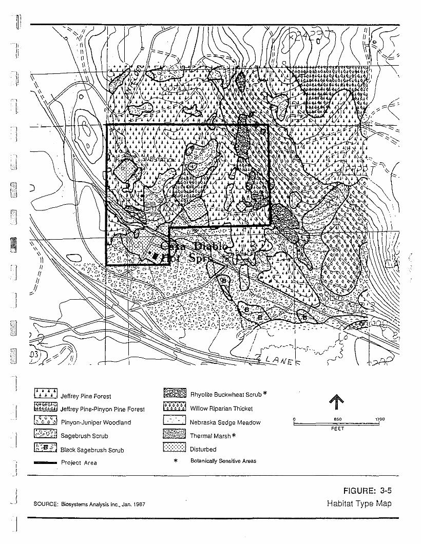
dBV'Jad"lIBl!qBH
S-£:3!:JnDI::I
se6J'v'a"!1!sues,.{Ue:J!u~oa*
L96~'uer'":JulS!sl.teuvSW81S,.(S0!8:30CfnOS
eeJVloafoJdr
IsaJO~aUld'\aJuar(,',,I Itt!
foaLl
133:f
0'.
~
Io
paqmlslOI::::::::::::J
*LjSJBV'JjEWJ8Lj.L~:":"~~;,\';,'IMJ,·..•..:::'c.~
MOpEal/'ja6pasE~SEJqaNI:"".,la~ol~J.UE!JEd!l:iMOII!Mr.:.:.:.:.!
*qmosIEa~M~on8al!lo'\~!:i~
qnwS~snJqa6es~oE18
qnJOS~snJqa6ES
PUEIPOOMJad!unr,uO'\Uld
t,;:S:~:;1
!";;';;"fl •~J••~.,
IX_,~.~
c (",~
•
Iil:1
I~
3.0 Affected Environment
and sagebrush habitat. Activities on the site may affect animals in these habitats and
many animal species are expected to cross the site in their daily and seasonal movements.
The Jeffrey pine forest is young and relatively open with few snags (standing dead trees)!
and little dead and down wood. This limits its value to cavity nesting birds such as pygmy
nuthatches and hairy woodpeckers (Airola, 1980). These three species are fore,t service
management indicator species. The shrub understory of sagebrush, bitterbrush and
tobacco brush, provides food for species such as mule deer, whi te-tailed jackrabbit,
western wood pewee, and song sparrow. American robins and mourning dove are expected
to nest in the pines, and the cones provide seeds for chipmunks, scrub jays and Clark's
nutcrackers.
The sagebrush scrub habita t is expected to be used by vesper sparrows, sage thrashers,
green tailed towhees and brewer's sparrows. Typical rodents using this habitat are
belding's ground squirrel, Citellus beldingii, merriams kangaroo rat Dipodom.J§ merriami,
and desert wood rat, Neotoma lepida (Ingles, 1965).
Predators in the area are expected to use both sagebrush scrub and Jeffrey pine forest.
The most abundant of these is the coyote with badger, and bobcat common (Ingles, 1965;
USFS, 1986). Rattlesnakes and gopher snakes are expected in the vicinity of the site
during the warm spring and summer months (Stebbins, 1985; WESTEC, 1986).
I
3.2.3 SPECIAL INTEREST SPECIES .'
There are several wildlife species of special interest pertinent to the area. These are
important due to their recreational value, special legal status, or their use by the USFS as
indicator species for habitat quality.
Mule Deer. Mule deer. are recreationally import"n~ in the MarTu;.cth Lakes area, both
consumptively and non-consumptively. Currently deer populations in the "rea ar~ stable
and healthy, after a period of decline in the 1950s and 1960s (Kucera, 1987a; Thomas,
1986a; Thomas, 1986b). The Sherwin Grade Deer Herd, the Buttermilk Deer Herd, and the
Casa Diablo Deer Herd use the area around Mammoth Lakes, including the MP II & III
sites. These herds are migratory, with the yearly cycle of movements tied to weather
patterns and food resources. The breeding biology of the deer is adapted to their
movements. The winter range, summer range, staging areas, and migration corridors are
3-36t
)
I
IJ
3.0 Affected Environment
all vital links in the life histories of these herds.
The Sherwin Grade Herd winters in the area west of Highway 395, north of Pine Creek,
generally south of Sherwin and Swall Meadows, and east of Wheeler Ridge (Kucera,
1987a). The plant community is sagebrush scrub, with sagebrush bitterbrush, and
rabbitbrush as co-dominants. Bitterbrush is an important winter food and is supplemented
by grasses and forbs in years with little snow cover. Winter deer counts yield estimates of
2,300 to 2,400 animals for the herd (Thomas, 1986a).
The Buttermilk Herd winters just south of the Sherwin Grade Herd and numbers
approximately 2,000 animals. The plant communities in its winter range are similar to
those of the Sherwin Grade Herd (Kucera. 1987b).
The Casa Diablo Herd numbers about 1,500 animals. They winter east of the Owens
River, from Casa Diablo Mountain north and east to the California-Nevada border.
Truman Meadow, Marble Creek, and a narrow strip of habitat between Black Rock Mine
and Casa Diablo Mountain are the major wintering areas for this herd. The plant
communities of these areas are similar to those of the Sherwin Grade and Buttermilk
Herds winter range. with the addition of some pinyon pine habitat (Thomas, 1986b).
With the onset of spring, deer from both herds begin a leisurely migration west and up the
Sierra slope. Generally this begins in mid-April. The routes, defined by the rugged.'
topography of the Sierra, are traditional: young deer learn the routes from their parents
and other members of the herd. Solitude Canyon, Mammoth Pass, and Duck Pass are the
key migration routes over the mountains used to reach the summer range. To reach the
passes, Sherwin deer move north from the wintering grounds, generally staying west of
Highway 395 and east of the base of the Sierra. Some deer from the Sherwin Herd are
thought to cross Highway 395 and use the habitats around Casa Diablo Hot Springs
(McCarthy, 1987). A large staging area for deer migration lies southwest of the site, on
the west side of Highway 395. This staging area is used by several thousand deer during
spring migra tion. Deer from the Casa Diablo Herd are known to cross the proposed site as
they migrate toward the Sierran summer range. About half of the 6,000 members of the
three deer herds pass near the town of Mammoth Lakes, on their .way to their summer
ranges (Kucera, 1987bJ. A study of the migration in spring 1987 near Casa Diablo
indicates that several dozen deer use the immediate vicinity of Casa Diablo during the
spring migra tion (Kucera. 1987b). A copy of the report is in Appendix C.
3-37
3.0 Affected Environment
The Buttermilk Herd winters south of the Sherwin. Grade Herd and numbers
approximately 2,000 animals. The plant communities in their winter are similar to those
of the Sherwin Grade Herd winter range (Kucera, 1987b).
Deer reach their summer range in approximately two months. The summer ranges of the
two herds overlap and cover a much greater area than the winter range. The deer summer
throughout the Ansel Adams Wilderness and over the crest to the west slope of the
Sierra. Fawning occurs on the summer range (Thomas, 1986a).
The return migration in the fall is more rapid than the spring migration. It is triggered by
the first storm which blankets food resources. This requires about two inches of snow at
the 7,OOO-foot level. The fall 1986 to winter 1987 migration was atypical as no major
storms arrived until January 1987. Thus deer moved downslope gradually over a period of
several months. The same routes are used on fall migration as are taken on spring
migra tion (Kucera, 1987a).
Sage Grouse. Sage grouse, Centrocercus urophasianus, are large upland game birds which
are year round residents in the Mammoth Lakes region (McCarthy, 1987). They are USFS
management indicator species for sagebrush plant communities (McCarthy and Hargis,
1984). Sage grouse inhabit, and are intimately tied to, sagebrush communities. Sagebrush
stands prov:ide nesting sites and thermal cover in spring and summer. During the winter,
grouse cOLsume sagebrush almost exclusively (Airola, 1980). Meadows arid grasslands are
heavily used during spring and summer, providing green forbs, seed, and insects.' These
food sources are particularly important jp raising young.
Grouse use large open areas in the sagebrush for strutting grounds, known as "leks", during
the breeding season. These leks are traditional sites in which grouse congregate and
where the males perform courting displays (Call and Maser, 1985). After mating, females
disperse to nest and raise the young. These leks are an important part of the habitat
needs of this species. Major areas of sage grouse leks are in the Lake Crowley and Bodie
areas. There are no leks in the immediate vicinity of the MP II & III site (McCarthy, 1987).
Sage grouse populations in the area severely declined about 10 years ago. In 1982, the
sage grouse hun ting season was closed and since that time, the local grouse popula lion has
approximately doubled. Now there are an estimated 1,000 grouse in the Lake Crowley/
Glass Mountain/Bald Mountain area.
3-38
1
I
I!
I
11
l]
3.0 Affected Environment
Special Status Species. Several special status animal species with potential to occur on or
around the project site are found in the Mammoth region. No special status species have
been observed on project site.
Bald eagles (Haliaeetus leucocuphalus) use the Owens River valley during winter
migration (McCarthy, 1987). This species is listed as endangered (U.S. Fish and
Wildlife Service, 1986). A single individual was observed by Taylor and Buckberg
approximately one mile east of the site. There are no roosting or feeding sites on the
study si te or in the immedia te vicini ty.
Peregrine falcons (Falco peregrinus) have been released at a site approximately
20 miles away as part of a reintroduction program for this endangered species (U.S.
Fish and Wildiife Service, 1986). Peregrines could visit the site on hunting forays.
There is no nest nesting habitat on or near the Mammoth Pacific site.
Swainson's hawks (Buteo swainsoni) breed in riparian areas in the Great Basin. They
have bred at Lake Crowley, approximately nine miles southeast of the project site
(Airola, 1980). This is a federal candidate species, Category 2; that is, the U.S. Fish
and Wildlife Service has some evidence for listing it as endangered, but conclusive
evidence is not available (U.S. Fish and Wildlife Service, 1986). Swainson's hawks
may use the site vicinity for foraging, but there is no nesting habitat on or near the
site...
Ferruginous hawks (Buteo regalis) are winter visitors in the Mammoth area, using
grasslands for foraging (Airola, 1980). This species, like the Swainson's hawk, is a
federal candidate, Category 2 (U.S. Fish and Wildlife Service, 1985). They are not
expected to use the habitats on site.
Golden eagles (Aguila chrysaetoes), year long residents in the region, are protected
by the federal Bald Eagle Act. There are known nest sites near Bridgeport and
Benton (Airola 1980). Golden eagles probably occasionally use the project vicinity for
foraging.
3-39
3.0 Affected Environment
Owens Valley vole (Microtus califomicus vallicola) is listed as a federal candida te
species, Category 2 (U.S. Fish and Wildlife Service, 1985). They are Imown to occur
in the Owens Valley in southern Mono County, though little is Imown of their precise
distribution. Voles are primarily inhabitants of grasslands, meadows and riparian
areas (Ariola, 1980). They are not expected to occur on-site.
Owens River Tui chub (Gila bicolor snyderi) is a federally listed endangered species
which is found in the springs near the headwa ters of Hot Creek. The U.S. Fish and
Wildlife Service will issue a biological opinion on the Owens River Tui chub pursuan t
to Section 7 of the Endangered Species Act.
3.2.4 AQUATIC ENVlRONMENT
The major waters near the project area consist of hot springs, artesian springs and surface
waters. No perennial streams are found on the project area itself, but there is an
ephemeral stream draining the site. The area is within the watershed of Mammoth Cree; .
a perennial stream fed by rainfall, snowmelt and springs. Surface water temperatures
range from 10° to 14°C (WESTEC, 1986). Water quality may be influenced by construction
and waste inputs from human activity near the city of Manunoth Lakes and nutrient in the
puts by grazing livestock along its streambanks. Three hot springs (AB, CD, HI; see
Figure 3-3) form the headwaters of Hot Creek and average 11° to 16°C in temperature
(WESTEC, 1986). Hot Creek Hatchery, managed by California Department of Fish and
Game (CDFG), is situated in this area and takes advantage of this water sourc€' in its
hatchery operations. A fourth hot spring (H2,3) enters into Hot Creek below the hatchery
facility; downstream from this point Mammoth Creek joins with Hot Creek. The creek, as
it flows east and north towards the Owens River, gradually increases in temperature as
inflow from hot springs within the stream channel and along its banks augments the
stream flow and raises its temperature.
Both Manunoth and Hot Creeks support naturally spawning populations of rainbow and
brown trout. The only stocking activity carried out by CDFG in the project area takes
place in Mammoth Creek upstream of Highway 395. Fishing activity is great in both
creeks; however, Hot Creek is one of only two state-classified wild trout fisheries in the
!nyo National Forest (USFS, 1986) and is one of the few trophy trout streams in
3-40
I
i
I

j
I:'
li
I.
!
3.0 Affected Environment
California. The brown trout in Hot Creek exhibit exceptional growth due to the
geothermal enhancement of the stream water. The elevated temperatures increase
primary and secondary productivity, in the form of aquatic plants and nwnerous insects,
as well as raising the metabolic ra tes of resident trout. Below the confluence of
Mammoth Creek and Hot Creek, fishing regula tions are such tba t only artificial dry flies
on barbless hooks may be used and any fish caught must be released unharmed. These
restrictions are strictly enforced and apply upstream through the Hot Creek Ranch
property, a private, commercially operated fishing facility, and downstream to the Owens
River.
The hot springs also provide a unique habitat for the endangered Owens River Tui chub
(Gila bicolor snyderi). The distribution of this sub-species of Tui chub has been gradually
restricted by the development of dams and subsequent water withdrawals within the
Owens River watershed. It now exists in scattered refugia in the drainage area, with the
hot sPrings around the fish hatchery included as one of these refugia. To date a recovery
plan for this fish has not been written; however, U.S. Fish and Wildlife Service will issue a
biological opinion based on a Section 7 consui ta tion in progess.
The Hot Creek Hatchery is one of four major fish ha tchery facilities in the state and is
one of the oldest. It was brought into operation in the 1930's and operations include
production of trout eggs for other state hatcheries; rearing of fingerlings and ca tchable
trout to be stocked in Sierran streams, lakes, and reservoirs; and production of brood
stock for future egg production. Approximately 22 million eggs are produced pir year
from this hatchery, about 1.25 million fingerlings are taken to other CDFG regions for
stocking and at least 700,000 catchable trout (nine to 10 inches) are stocked in Alpine and
Mono county waters (Eichmann, 1987a).
There are a total of seven strains of both domestic and wild trout that are raised at the
hatchery. Early spawning in some of the brood stock strains has been genetically selected
for, in a practice that has continued for at least the past thirty years. These trout, under
natural conditions, would spawn in the fall; however, over time these selected strains have
been induced to spawn in the summer months. This method allows for more rapid growth
so that the young can be used in the following spring for stocking purposes.
3-41

3.0 Affected Envirorunent
3.3 SOCIAL ENVIRONMENT
3.3.1 VISUAL RESOURCES
3.3.1.1 Existing Programs, Plans, and Policies for Managing Visual Resources
3.3.1.1.1 County Plans and Policies
The Scenic Highways Element to the Mono County General Plan designates State
Route 203 and Highway 395 as scenic highways. This scenic designation is intended to
protect and enhance the visual envirorunent in areas of particular scenic value. In order
to promote uniform environmental review of projects in the area, the Mono County Office
of Energy Management intends to use the framework established by the USFS to evalua te
visual impacts as wel1 as requiring site specific mi tiga tion through the conditions of the
CUP. A description of the USFS Visual Mangement System (VMS) is described below.
3.3.1.1.2 Bureau of Land Management (BLM) Policies
GRO Order 4 (U.S. Geological Survey, Conservation Division, 1976) requires lessees of
geothermal resource areas under federal jurisdiction to reduce the visual impact of
geothermal development through careful site selection and through sensi tive design and
construction of facilities.•
3.3.1.1.3 Forest Service Plans and Policies
The USFS's Environmental Concern Maps for the Geothermal Lease Area, lnyo National
Forest (USFS, 1980), designate the proposed project site, and most adjacent areas along
Highway 395, as Visual Resource Constraint Level 2, where surface occupancy should bt
limited to controlled off-road vehicle use, and surface occupancy for geothermal
activities should be excluded "unless surface management concerns can be mitigated."
Furthermore, the Draft Land and Resource Management Plan, lnyo National Forest (USFS,
1986b) designates the project area for "Retention." Management policy for Retention
areas is to al10w only activities and facilities that are not evident to the casual visitor.
The Management Area Directions for visual resources include "working toward mitigation
of existing major detracting uses" in the "seen area" from Highway 395. The visual
3-42
.]
I
]
J
j
J

IT] Retention
'0 Partial Retention
*..A"'" Major View Point of Concern
..,r ) ~ I
e:.-~ . LEGEND
SOURCE: U. S. . e 1987.Forest Servlc ,
FIGURE: 3·6b·ectives andVisual Quality 0 tasa Diablo
. r Viewpoint nearMaJo
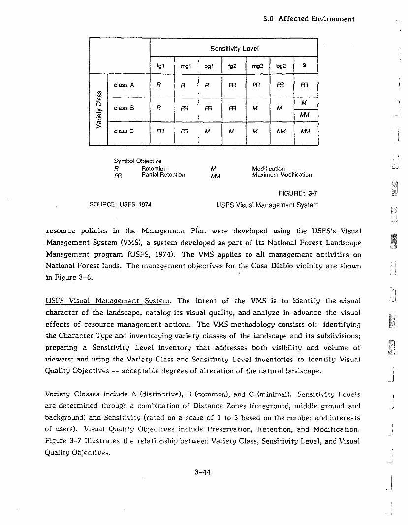
3.0 Affected Environment
Sensnivny Level
Ig1 eng1 bg1 Ig2 eng2 bg2 3
class A R R R Ffl Ffl Ffl Ffl
~E! M()
class B R Ffl Ffl Ffl M M:i?:'Q) AM.C:
'">AMclass C Ffl Ffl M M M AM
Symbol ObjectiveR RetentionFfl Partial Retention
MM..f
ModfficationMaximum Modification
SOURCE: USFS, 1974
FIGURE: 3-7
USFS Visual Management System
resource policies in the Managemerit Plan were developed using the USFS's Visual
Management System (VMS), a system developed as part of its National Forest Landscape IManagement program (USFS, 1974). The VMS applies to all management activities on
National Forest lands. The management objectives for the Casa Diablo vicinity are shown
in Figure 3-6.
USFS Visual Management System. The intent of the VMS is to identify the. <Visual
character of the landscape, catalog its visual quality, and analyze in advance the visual
effects of resource management actions. The VMS methodology consists of: identifyin'l
the Character Type and inventorying variety classes of the landscape and its subdivisions;
preparing a Sensitivity Level inventory that addresses both visibility and volume of
viewers; and using the Variety Class and Sensitivity Level inventories to identify Visual
Quality Objectives -- acceptable degrees of alteration of the natural landscape.
Variety Classes include A (distinctive), B (common), and C (minimal). Sensitivity Levels
are determined through a combination of Distance Zones (foreground, middle ground and
background) and Sensitivity (rated on a scale of 1 to 3 based on the number and interests
of users). Visual Quality Objectives include Preservation, Retention, and Modification.
Figure 3-7 illustrates the relationship between Variety Class, Sensitivity Level, and Visual
Quality Objectives. I3-44
j
I
11"
1:
J
3.0 Affected Environment
3.3.1.2 Sensitive Receptors
All people exposed to the landscape proposed for modification are considered to be
sensitive receptors. Expectations and aesthetic concern varies with the viewer, so that
the response of a particular viewer is highly subjective. In general, the USFS considers
recreationists to be the major viewing population, but for purposes of analyzing visual
impacts in the project area, the USFS does not distinguish between first-time viewers and
repeat viewers or resident and non-resident viewers (Rickford, 1987).
3.3.1.3 Regional Setting
The visual character of the region in which the project site is set is dramatic and is one of
the primary attractions for visitors to the Mammoth Lakes area. The project site lies on
the edge of Long Valley on the eastern side of the Sierra Nevada. The snow-capped peaks
of the Sierra Nevada, several of them over 14,000 feet in elevation, rise abruptly to the
west from a base elevation of about 7,500 feet. The rugged topography and the young
geology of the region provide several visual resources of particular scenic value, including
Harnmoth Mountain, Hammoth Rock, Crystal Crag, Devil's Postpile, and Long Valley.
Long Valley is a large, sparsely vegetated basin that drops away from Highway 395 to the
east, affording sweeping vistas. Devil's Postpile National Monwnent, Minarets
Wilderness, and John Huir Wilderness are local natural areas of high-quality visual
resources preserved for the enjoyment of the general public.•
The vegetation and wildlife of the region contribute to its high visual quality. Overall,
the variety of vegetation and topographic features is high. Patches of pine forest and
meadow, barren rock outcrops and avalanche slopes, chapparal and sagebrush add texture
and color. Low ridges and isolated hills break the view and create contained views of
distinctive landscapes. Wildlife is abundant in the area and views of deer, hawks, eagles,
rabbits, and other animals greatly enhance the aesthetic experience both for those
pursuing recreational activities in the more isolated portions of the region, and for
residents and visitors traveling local roads and highways. The water of streams, lakes,
seeps, and snow is an attractive visual element common in landscapes visible from
regional public viewpoints.
3-45

3.0 Affected Environment
3.3.1.4 Project Area
The project site is a gently sloping area of primarily sagebrush scrub and scattered pine
trees on the northeastern side of Highway 395 near the terminus of State Route 203. Hot
Springs Road provides access to geothermal development areas near the project. The
existing geothermal development, MP I, lies southwest of the project site. A network of
existing roads to the MP I well fields covers most of the project area.
The project site lies about 1,600 feet northeast of Highway 395 and about 600 feet
northwest of State Route 203, at their nearest approaches. The project site is open to
view by motorists traveling northeast on State Route 203 east of Highway 395. Traffic
volumes on State Route 203 are small and, thus, public exposure of the site from this
public viewpoint is minor. The general project area is visible from portions of State
Route 203 west of Highway 395 and also from portions of Sawmill Road, but the power
plant site itself cannot be distinguished from adjacent areas at these distances. The
power plant site is also open to view from Highway 395, from about 5,000 feet southeast
of its junction with State Route 203 to about 4,600 feet northwest of that junction. The
clearest views of the proposed power plant site along Highway 395 are for the northbound
travel lanes, from about 4,600 feet to about 2,000 feet southeast of its junction with State
Route 203. A long, low forested ridge to the north of the project site provides a
backdrop, as viewed from Highway 395, that serves to minimize the visibility of individual
features of the site and of the existing MP I geothermal development northwest of the
site. •
Highway 395 itself, local roads, the County buildings and impound yard, the
Mammoth-June Lakes Airport, the Town of Mammoth Lakes, electricity transmission
lines, fences, the existing geothermal development, and gas and propane storage tanks -
with their regular outlines, even texture, and colors atypical of the natural
environment -- can be seen from the major viewpoint located south of the project area on
Highway 395. Mining activities and roads providing access to mining claims and
recreational areas also contrast with the generally natural landscape. In the daytime,
sunlight reflects from metal and glass surfaces; at night, lights from structures and from
cars on Highway 395 can be seen within the generally uninterrupted darkness typical of
the natural areas along Highway 395. Night lighting from the existing geothermal plant at
Casa Diablo may attract the attention of motorists on Highway 395, State Route 203, and
Sawmill Road.
3-46
I
I
'1 :! :
II1
3.0 Affected Envirorunent
3.3.2 SOCIOECONOMICS
3.3.2.1 General Socioeconomic Characteristics
The population of the Mammoth Lakes region has dramatically increased during the last
two decades. The population grew from 2,213 in 1960 to 4,016 by 1970 and more than
doubled to 8,577 by 1980. The rate of growth has slowed significantly in recent years and
is estimated to have reached 9,200 by July 1, 1986 (California State Department of
Finance, Population Research Unit, 1987). Most of the population of Mono County resides
in the recently incorporated Town of Mammoth Lakes, which has a year-round population
of approximately 5,000. Peak population on winter weekends reaches 35,000.
Employment is concentrated in the government, retail sales and service sectors, with
service employment mostly generated by tourism (Hawley, 1987). No residents live on or
immediately adjacent to the project site.
3.3.2.2 Land Use and Planning
The proposed sites for the MP II & II! geothermal plants and the well fields for MP II are
located on a private geothermal lease (Assessor's Parcels No. 37-050-02 and -05) in the
vicinity of the Casa Diablo Hot Springs. This lease is located in unincorporated Mono
County, approximately three miles east of the Town of Mammoth Lakes. When the
application for the Conditional Use Permit (CUP) was filed with the County, the property
was zoned General Purpose (GP) by the Mono County Zoning Ordinance and classffied as
Mixed lntensity Multiple (MM) by the Mono County General Plan. The MM designation
allows a variety of uses.
The site for well fields for MP III, located within the lnyo National Forest, is under the
jurisdiction of the BLM, which manages all geothermal resources on USFS land. The lease
(CA 11667A) is contained in Lease Block I, a parcel of 27,450 acres currently under
geothermal lease status. Adjacent to the site are approximately 2,560 acres owned by
LADWP, most of which is used for grazing livestock. The project is within the Long
Canyon Unit of the Hot Creek Grazing Allotment, administered by Inyo National Forest,
and at the southern edge of an area managed for commercial timber production. Two
115 KV transmission lines run from the SCE Casa Diablo substation, about one-quarter
mile north of the site, and continue south toward Bishop. Major land uses in the project
.! vicini ty are shown in Figure 3-8.
3-47
J
I
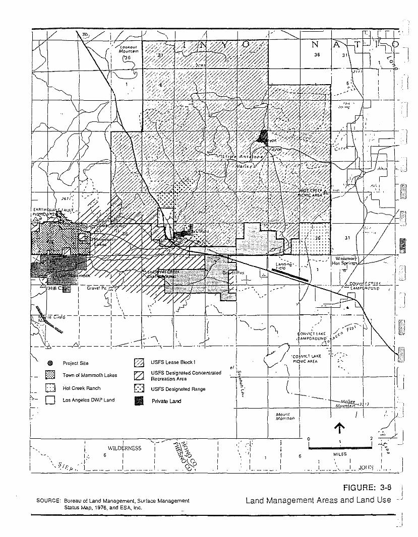
.JOfl~
,,MILES
36
N A
6
'\'~
:'('\·1, "I
I
/~~ '~fI'l1·\"~1~orNlc·Tl ... r::(. /c" I
'p'hMPGROIJN(l ""(. .
1----+--;,/"'1---',"-- __6.~ - ----LI,
/'CO~Vll'L.AKE ~./~-;,
'\ prAR~ __ :~" ~-i-i---+--!--CIi-- ,_._-L-- i J
T '-' Mdj" I:+ -+ t- -t-=MCJ.l!.~)['J -,-{-IMoo'" I,'. J"LJMomson ~.\
o 1" ,011c.... ...1 ~ '. J- , ;.
IWILD~RNESS
6 III
I,I ,~
's .1'" .,I!'H ,: 1.__ ,__
Ell Project Site E22 USFS Lease Block. I,I
8 fZ1 USFS Designated Concentrated ~
Town 0( Mammoth Lakes ..Recreation Area .
0 Hoi Creek Ranch 0 USFS Designated Range~
. " ' .~
0 Los Angeles OWP Land 11.1 Privale Land
-1I---"'----4----f----+-~.
L"I
I-------------------'---------------------~
~-If-i'--IrI
SOURCE: Bureau of Land Management, Surface Iv\anagementStatus Iv'.ap. 1976, and ESA, Inc.
FIGURE: 3-8 I
Land Management Areas and Land Use . J

3.0 Affected Environment
Land uses wi thin the vicini ty of the project si te include the following:
MP I power plant, immediately adjacent to the site;
Casa Diablo Substation, operated by Southern California Edison Company, about onequarter mile north of the site;
Mono County Buildings and impoundment yard, one and a quarter miles southeast ofthe site;
A liquid propane storage facility, one and a quarter mile southeast of the site;
Chance Ranch, a private ranch, approximately 1.5 miles east of the site;
Sherwin Creek Campground, one and one half miles southwest of the site;
Mammoth-June Lake Airport, three to four miles southeast of the site;
USFS GravellBorrow Pits at the north side of the airport;
Sierra Quarry, operated by Honeywell, at the south side of the airport;
Hot Creek Fish Hatchery, operated by the California Department of Fish and Game,three miles east of the site;
Old Mammoth School, southwest of Hot Creek Fish Hatchery;
Hot Creek Ranch, a private trout fishing resort, four miles east of the site; and
Shady Rest Campground, three miles west of the site.
The two major highways used for access to the MP II & III site are designated as pfficial
scenic highways. Highway 395, from post mile 18.0 near the southern edge of Long Valley
to post mile 26.9, 1.1 miles north of State Route 203, is an official state scenic highway.
Highway 395 from the Tioga Turnoff to the !nyo County Line, and State Route 203 from
the Highway 395 junction to the Sierra Park Road junction are official county scenic
highways. As required under state law the Mono County Planning Department has
developed a program for protecting and enhancing these scenic corridors (California
Department of Transportation, 1982). The adopted Mono County Scenic Highway Element
requires that utilities be located and designed in a manner which minimizes visual
impacts. The Element also requires that visually offensive land uses be adequately
landscaped and screened (Mono County, 1981b).
3-49
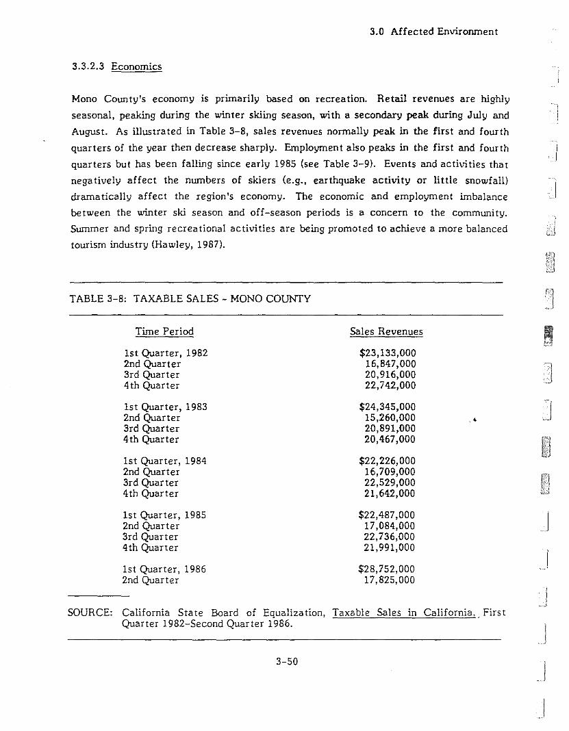
3.0 Affected Environment
3.3.2.3 Economics
Mono County's economy is primarily based on recreation. Retail revenues are highly
seasonal, peaking during the winter skiing season, with a secondary peak during July and
August. As illustra ted in Table 3-8, sales revenues normally peak in the first and fourth
quarters of the year then decrease sharply. Employment also peaks in the first and fourth
quarters but has been falling since early 1985 (see Table 3-9). Events and activities that
negatively affect the numbers of skiers (e.g., earthquake activity or little snowfall)
dramatically affect the region's economy. The economic and employment imbalance
between the winter ski season and off-season periods is a concern to the community.
Summer and spring recreational activities are being promoted to achieve a more balanced
tourism industry (Hawley, 1987).
TABLE 3-8: TAXABLE SALES - MONO COUNTY
Time Period Sales Revenues
1st Quarter, 1982 $23,133,0002nd Quarter 16,847,0003rd Quarter 20,916,0004th Quarter 22,742,000
1st Quarter, 1983 $24,345,0002nd Quarter 15,260,000 .'3rd Quarter 20,891,0004th Quarter 20,467,000
1st Quarter, 1984 $22,226,0002nd Quarter 16,709,0003rd Quarter 22,529,0004th Quarter 21,642,000
1st Quarter, 1985 $22,487,0002nd Quarter 17,084,0003rd Quarter 22,736,0004th Quarter 21,991,000
1st Quarter, 1986 $28,752,0002nd Quarter 17,825,000
SOURCE: California State Board of Equalization, Taxable Sales in California.. FirstQuarter 1982-Second Quarter 1986.
3-50
JJJI

3.0 Affected Environment]":._") 1
II
II .
11
TABLE 3-9: EMPLOYMENT IN MONO COUNTY
Time Period
1st Quarter, 19832nd Quarter3rd Quarter4th Quarter
1st Quarter, 19842nd Quarter3rd Quarter4th Quarter
1st Quarter, 19852nd Quarter3rd Quarter4th Quarter
1st Quarter, 19862nd Quarter3rd Quarter
Persons Employed
4,6584,5754,8174,808
4,7084,5124,5584,675
5,1004,5504,5424,583
4,4674,2334,100
1u
I
J
J
j
j
SOURCE: California State Employment Development Department, California LaborMarket Bulletin, January 1983-0ctober 1986.
The unbalanced nature of the local economy due to its heavy reliance on rec:r.eation
activities is revealed in the 1983 survey of the Mammoth Lake labor force summarized in
Table 3-10. The survey found no employment in the agricultural, mining, or
manufacturing sectors; however, 37% of the labor force was employed in the recrea tional
and service sectors. A large construction sector, 3.5 to four thnes California's state-wide
average, was also present (Earth Metrics, 1984). The operating geothermal plant, MP 1,
provides 16 full-time jobs, approximately 0.2% of the local labor force. Eleven of these
jobs filled by residents of Mono County (Asper, 1987b).
The California Department of Fish and Game's Hot Creek Hatchery is important to the
economics of the State's trout program. One of only three rainbow trout brood stock
hatcheries in California, Creek Hatchery provides approximately 20 million fish eggs for
use in· the State's year-round trout program and for use by hatchery systems of several
3-51

3.0 Affected Environment
TABLE 3-10: D1STRlBlTfION OF MAMMOTH LAKES' LABOR FORCE BYEMPLOYMENT SECTOR, 1983 SURVEY
Sector
Agriculture, Forest, FishMining, ManufacturingCons truc tionTransportation, UtilitiesRestaurant, BarWholesale, Re tail TradeFir.ance, Insurance, Real Es ta teRecreationServicesGovernmentLodging, Property Management
Total Number of Employees
Percen t of All Employees
oo
143
1016
625126.5
10
5,559
SOURCE: Earth Metrics, Inc. 1984. Mammoth Lake Housing Study Needs.
Iother western states. Hot Creek Hatchery is also responsible for the production and
planting of 7UO,000 catchable trout annually in the Inyo-Mono area and handles the major
part of backcountry aerial planting in the northern Sierra Nevada. A unique fall spawning
strain of rainbow trout, developed at the Hot Creek Hatchery, and the constant, high..temperature of the rearing ponds, provides fish of a plantable size up to six months earlier
than typical rainbow trout. This gives California the capability to plant trout all year
long. The California Department of Fish and Game suggested a method to quantify the
"dollar value" of the recreational days provided by fish and eggs from Hot Creek Ha tchery
in 1976. The method involves estimating the number of recreational and angler days
supported through visitor use and fish/egg production at Hot Creek Hatchery and
multiplying these amounts by the estimated value (I.e., associated consumer expenditures) Jof a recreational day and an angler day, respectively. The following values were
estimated: .1
Direct Angier DaysIndirect Angler DaysDirect General Recreation
TOTAL
3-52
$6,545,0002,873,000
48,562$9,466,562
)
!I]
1Ii
)j
11
j\
]
IJ
J
3.0 Affected Environment
In detennining the value of direct angler days, the Department of Fish and Game
estimated that 770,000 of the 2,650,000 fishes produced annually at the hatchery would be
caught by anglers. Based upon the assumptions that. the average angler catches two
fishers per day and that the value of an angler day is $17.00, the fISh produced at the
hatchery would support 385,000 angler days, worth $6,545,000. The value of indirect
angler days was based on a fraction, ten percent, or the value of angler days supported
through fish egg production. The Department of Fish and Game estimated that the
10 miJIion fish eggs shipped from the hatchery will result in approximately
3,380,000 fishes caught by anglers. These were estimated to produce 1,690,000 angler
days valued at $28,730,000. Applying 10% as the contribution attributable to the egg
production, the indirect angler days supported by egg production at the ha tchery was
valued at $2,873,000. Finally, the direct general recreational value of the hatchery was
based on an estimate of visitation to the hatchery amounting to 24,281 general use days.
Assuming the value of a general recreational day to be $2.00, the hatchery itself yeilded a
direct general recreational value of $48,562. These values are all based on 1976 dollars
(Fullerton, 1976). Adjusted for inflation, a simular "dollar value" today would equal over
$19,000,000 annually.
3.3.2.4 County Fiscal Considerations
Mono County receives revenues from a variety of sources. Total revenues for fiscal year
1985-86 were $13,517,524. Approximately 41.6% came from state, federal and other
government sources. The remaining 58.4% was from local sources, with taxes accounting
for 43.2% of total revenues. Charges for county services, licenses and permits accounted
for 11%. Income from the use of money and property amounted to about 1.9%. The
remaining 2.3% came from miscellaneous sources. The actual dollar amounts of revenues
from each of the above sources are swnrnarized in Table 3-1 J. Geothermal activities
accounted for about 6.3% of the revenues. Through possessory interest the county
benefi ts from the ad valorem (property) tax revenues paid on the value of geothermal
facilities even when the facilities are located on federal land. When the geothermal lease
occurs on federal lands, the state receives 50% of the federal lease royalties and rentals
and redistributes 20% of the original amount to the county. In aden tion, geothermal
activity at the existing MP 1 plant supported purchases from merchants in Mono and Inyo
Counties totaling $159,000 in 1986 and a direct payroll of $451,173 in 1986 which
indirectly increased sales tax revenues (Asper, 1987b).
3-53
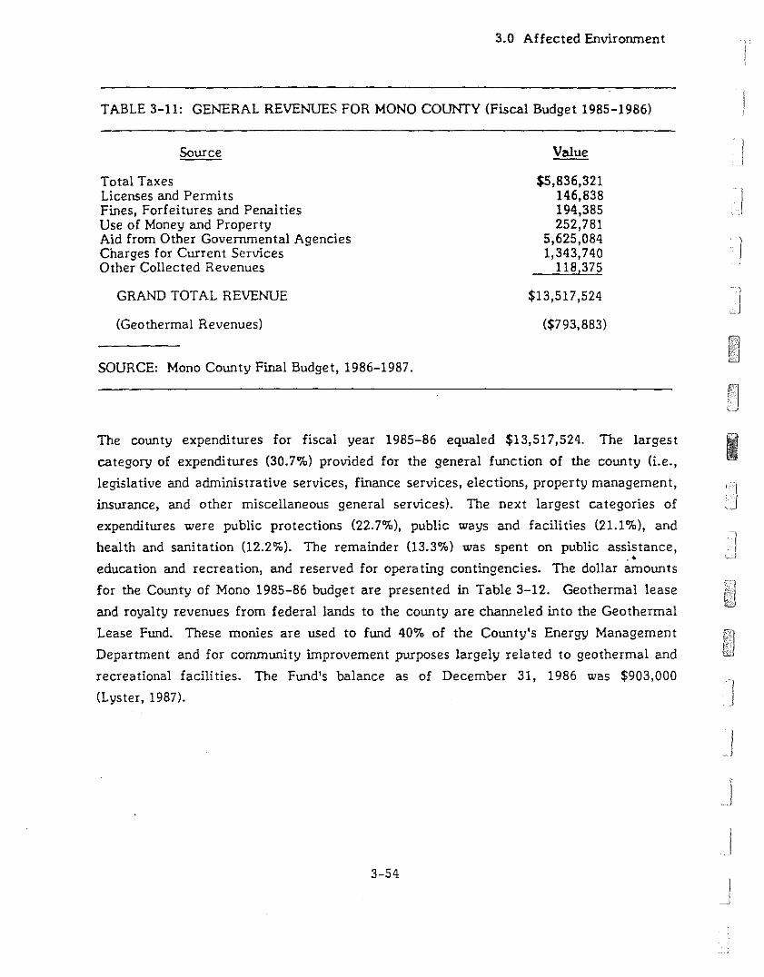
3.0 Affected Environment
TABLE 3-11: GENERAL REVENUES FOR MONO COUNTY (Fiscal Budget 1985-1986)
Source
Total TaxesLicenses and PermitsFines, Forfeitures and PenaltiesUse of Money and PropertyAid from Other Governmental AgenciesCharges for Current ServicesOther Collected Revenues
GRAND TOTAL REVENUE
(Geothermal Revenues)
SOURCE: Mono County Final Budget, 1986-1987.
$5,836,321146,838194,385252,781
5,625,0841,343,740
118,375
$13,517,524
($793,883)
I
I)
The county expenditures for fiscal year 1985-86 equaled $13,517,524. The largest Icategory of expenditures (30.7%) provided for the general function of the county (i.e.,
legislative and administrative services, finance services, elections, property management,
insurance, and other miscellaneous general services). The next largest categories of
expenditures were public protections (22.7%), public ways and facilities (21.1%), and
health and sanitation (12.2%). The remainder 03.3%) was spent on public assistance, -).• ,~"J
education and recreation, and reserved for operating contingencies. The dollar amounts
for the County of Mono 1985-86 budget are presented in Table 3-12. Geothermal lease
and royalty revenues from federal lands to the county are channeled into the Geothermal
Lease Fund. These monies are used to fund 40% of the County's Energy Management
Department and for community improvement purposes largely related to geothermal and
recreational facilities. The Fund's balance as of December 31, 1986 was $903,000
(Lyster, 1987).
3-54
J
j
I__I
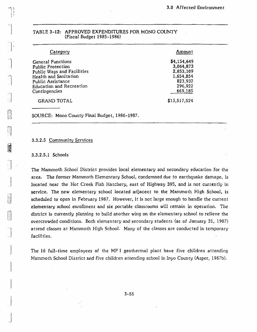
~...,., "I
i;I;
3.0 Affected Envirorunent
TABLE 3-12: APPROVED EXPENDITURES FOR MONO COUNTY(Fiscal Budget 1985-1986)
II
Category
General FunctionsPublic ProtectionPublic Ways and Facili tiesHealth and SanitationPublic AssistanceEducation and RecreationContingencies
GRAND TOTAL
SOURCE: Mono County Final Budget, 1986-1987.
3.3.2.5 Corrununi ty Services
3.3.2.5.1 Schools
Amount
$4,154,6493,064,8732,853,1091,654,854
823,932296,922669,185
$13,517,524
1
1
1
J
]
I)
II
The Marrunoth School District provides local elementary and secondary education for the
area. The former Mammoth Elementary School, condemned due to earthquake damage, is
located near the Hot Creek Fish Hatchery, east of Highway 395, and is not currently in
service. The new elementary school located adjacent to the Mammoth High School, is
scheduled to open in February 1987. However, it is not large enough to handle the current
elementary school enrollment and six portable classrooms will remain in operation. The
district is currently planning to build another wing on the elementary school to relieve the
overcrowded conditions. Both elementary and secondary students (as of January 31, 1987)
attend classes at Mammoth High School. Many of the classes are conducted in temporary
facilities.
The 16 full-time employees of the MP I geothermal plant have five children attending
Mammoth School District and five children attending school in inyo County (Asper, 1987b).
3-55
3.0 Affected Environment
In addition to the problem of overcrowding, the district is also affected by the influx of
"transient" students during the winter season. The enrollment level as of January 1987,-j
was 368 elementary students and 293 secondary students. Enrollment drops off just after
Easter when the skiing season ends and seasonal employees move their families away. The -I1987 faculty consists of 14 full-time elementary teachers, one part-time elementary
teacher, 16 full-time high school teachers, two part-time high school teachers, and one
district teacher. Staffing is not affected by the seasonal variation in enrollment (Martin,
1987).
3.3.2.5.2 Police
Law enforcement is provided by the Mono County Sheriff's Department headquartered in
Bridgeport. There are a total of 37 personnel in the department, 24 sworn officers and
13 public safety officers. The closest officers to the site are four resident deputies
loea ted a t Crowley Lake providing coverage on an on-call basis. Priori ty response time to
the site is estimated at five to 10 minutes (15 minutes in the early morning if no one is on
duty). Non-j,riority response is on an "as avai:able" basis. The substation that previously
serviced the site, located at Old Highway 395 and Sherwin Creek Road, was abandoned in
July-August 1986. The California Highu"ay Patrol has primary responsibility for traffic
control and accident in"estigation for State Route 203 and county roads. The Sheriff's
Department maintains mutual aid agreements with all surrounding law enforcement
agencies (Le., USFS, Highway Patrol, Mammoth Lakes Police, and Department of Fish and
Game). These agencies are called upon only in emergency situations as back-up. to the
Sheriff's Department. All arraignments and hearings are held in the Bridgeport
courthouse, requiring officers to travel there for testimony and prisoner transfer. No
incidents have been reported as of January 26, 1987, at the adjacent MP I geothermal
plant (Padilla, 1987).
3.3.2.5.3 Medical Facilities
The closest medical facility is the Centinela Mammoth Hospital located in the town of
Mammoth Lakes on Sierra Park Road. The Centinela Mammoth Hospital is accredited by
the Joint Committee on Hospitals and provides in-patient, out-patient, and 24-hour
emergency medical care. The hospital maintains 15 acute care beds (two in the intensive
care Unit, 13 for general services), the structure and equipment for emergency room
services, a complete diagnostic materials center, and a local clinic which provides
3-56
I
)
JJIJJ

1)1
II
11
"f
]
IIII
3.0 Affected Environment
staffing. The staffing level varies with the season, peaking with 75 personnel in the
winter and lowering to 50 in the sununer. Ten year-round physicians are on the staff. On
a year-round basis, the hospital only operates at 30% of capacity. However, the hospital
often operates at near-peak capacity during winter weekends. The second and third
nearest hospitals are Mono General Hospital in Bridgeport and Northern !nyo Hospital in
Bishop. Ambulance service is provided by the Mono County Paramedics for which the
Centinela Mammoth Hospital serves as a base station. Additional ambulance service is
provided by the Centinela Mammoth Hospital, Ground-Aegis Ambulance Service and the
Bishop Sierra Ambulance Service, the la tter two located in Bishop. Emergency
transportation services are provided for by Care Flight, based at Washoe Medical Center
in Reno, Nevada. Burn victims who require treatment beyond local capabilities may be
transported to burn centers in Las Vegas, Nevada, or Sherwin Oaks, California (Jacobsen,
1987).
3.3.2.5.4 Fire Protection
Local fire protection is provided by the Long Valley Fire Protection District. The district
operates three triple combination pumper engines (two capable of delivering 1,000 gallons
per minute and the third capable of 750 gallons per minute) and one automobile out of the
Hilton Creek Station located about five miles from the site. Staffing consists of
12 volunteer firefighters and one full-time Chief of Staff. Emergency response time to
Casa Diablo, when a crew is available, is estimated at 12 to 15 minutes. Due to its
proximity, the Mammoth Lakes Fire District, located on State Route 203 n~ar the
intersection of Pine Crest, responds to calls in the vicinity. The response time from
Mammoth Lakes is approximately seven minutes. The Mammoth Lakes fire station is
staffed by a full-time Chief, Assistant Chief and 50 volunteer firefighters. The
surrounding !nyo Na tional Forest lands are protected by the USFS, whic:' rates the area as
a "high fire hazard." Mutual aid agreements are in effect for all surrounding jurisdictions
and an automatic aid agreement with the Mammoth Lakes Fire Department. The
principal fire concerns in the Casa Diablo area are the use of isobutane at the MP I
geothermal plant, the distance from the fire stations, and the poor water supply. In the
event of a fire at Casa Diablo, nearby areas of concern are the traffic on adjacent
Highway 395; the three 10,000 gallon gasoline storage tanks owned by Chevron, located
one-quarter mile southeast of State Route 203 and one-eighth mile north of Highway 395;
and the 100,000 to 150,000 gallons of propane stored in six tanks owned by Cal-Gas,
3-57
3.0 Affected Envirorunent
Petro-Lane, and Turner, located approximately one mile east of the site. Fire safety
requirements governing construction are contained in the 1976 and 1982 Uniform Fire
Codes, with amendments, and special fire protection clistrict provisions (Malby, 1987).
3.3.2.5.5 Stree t and Road Maintenance
Street and road maintenance is provided by the County for all non-state and non-federal
county roadways. This re~;ponsibility includes road repair, maintenance, and snow
removal. Snow removal requires up to two-thirds of the total maintenance and
improvement budget (WESTEC, 1986). Private roads are maintained by owners.
3.3.2.5.6 Wastewater
)
]
The Mono County Water District operates a corrununity
treatment facility for residents of the Mammoth Lakes
system does not extend to the site area.
3.3.2.5.7 Solid Waste
sewage system and sewage
and Lakes Basin areas. The
IMarrunoth Disposal Service, a private carrier, provides bin service on a contractual basis.
The nearest sanitary landfill, a site leased from the Los Angeles Department of Wa ter and
Power, is located at Benton Crossing Road and is designated Class II, handling normal."
household refuse and construction debris. The Benton Crossing landfill has a projected
lifespan of 25 to 30 years (WESTEC, 1986).
3.3.2.5.8 Utili ties
The site is located outside of the water service area of the Town of Mammoth Lakes. A
well which supplies non-potable water is located at the adjacent MP I site.. The MP I
plant receives electrici ty from the Southern California Edison Company. During 1·-~6, the
electrical substations serving the immediate area had a combined designed capacity of
approximately 6.6 megawatts. The site area is currently served by the Continental
Telephone Company (Conte!) which has general offices and maintenance and switching
facilities in Mammoth Lakes (WESTEC, 1986).
3-58
J
J
J
J
Ini II .)): I,
3.0 Affected Environment
3.3.3 RECREATIONAL RESOURCES
The project area is three miles east of the town of Mammoth Lakes, which has
approximately 5,000 permanent residents. Located at the junction of the Great Basin and
the Sierra Nevada Mountains, the beauty and recreational resources of the area have
made Mammoth Lakes a popular resort. The nearby Mammoth Mountain Ski Area has
become the largest in the country, attracting over 17,000 persons a t one time (POAT)
during peak ski season (Morse, 1987).
Summertime recreation uses in Mammoth Lakes are estimated to attract over 1.5 million
visitors-days per year (USFS, 1980). Outdoor recreational activities include backpacking,
camping, fishing, mountaineering, swimming, and boating. There are two campgrounds
near the proposed site for MP Ii & Ill. The Sherwin Creek Campground is one mile
southwest of the site and the Shady Rest Campground is three miles west of the site.
There are approximately 32,700 visitors-days at Sherwin Creek and 92,200 visitors-days
to Shady Rest annually (Lloyd, 1987).
Hot Creek Hatchery, known for developing a unique strain of rainbow trout, is three miles
east of the site at the headwaters of Hot Creek. These trout are spawned in the fall, and
by the following spring their progeny have grown to approximately six inches in length and
are ready for stocking in local streams and lakes. Hot Creek Hatchery raises over 600,000
catchable size trout, and one million fingerling trout for stocking in the inyo-Mono area
annually (USFS, 1981). lmrnediately east of the hatchery, Hot Creek Ranch offers trophy
trout fishing from May 1st to October 30th. At the ranch there are nine to 11 cabins
available each season with five-person occupancy. During the fishing season the ranch
averages 15,000 to 20,000 visitor-days (Millikan, 1987). The Hot Creek recreational area
also contains Hot Creek Gorge, where hot springs emerge in Hot Creek. It is a favorite
recreational spot for visitors to the Mammoth area and is open to the public throughout
the year from sunrise to sunse t. Peak use of the hot springs is during the summer mon ths
when up to 300 individuals at one time use the bathing area (Lloyd, 1987). All totaled,
Hot Creek averages 95,000 recreational-visitor-days for swimming, fishing, site seeing
and guided tours (Lloyd, 1987).
Dispersed recreational activities near the project area include camping, wood collecting,
jogging, bicycling, snowmobiling, and deer hunting. The area bounded by Hot Creek,
3-59
3.0 Affected Environment
Highways 203 and 395, the Sherwin Creek recreational area, and Convict Lake, was
visited by approximately 3,000 game hunters during the 1986 season (Morse, 1987). There
are no existing recreational facilities within the project area. However Forest Road 3S05,
Highway 395, and State Route 203 are near the proposed site and serve as the main access
roads for the various recreational activities in the Little Antelope Valley.
3.3.4 TIMBER RESOURCES
The proposed project is located on the southern edge of an area within the lnyo National
Forest which is managed for commercial timber production. Species which are managed
for timber harvest include Jeffrey pine, red fir, white fir, western white pine, and lodge
pole pine. Six of the eight well sites proposed for USFS land are located in Jeffrey pine
forest. The other two sites are located partially in Jeffrey pine forest and partially in
sagebrush scrub. The facilities proposed for private property are less likely to affect
timber. The eastern third of the plant site and one well site is in a Jeffrey pine forest.
The other areas to be cleared have little timber. Some Jeffrey pine on the eastern end of
the project area may have commercial value; however, the proposed project area is not
located on land currently managed for commercial timber production. No timber volwne
measurements have been completed within the proposed project area (McLean, 1987).
3.3.5 RANGE RESOURCES
l'
I
I]
J
I
.'The USFS land proposed as part of the project is wi thin the Long Canyon Unit of the Hot
Creek Grazing Allotment. This allotment is under permit to Miller and Wood and is
administered by the !nyo National Forest. Although the private property is not part of the
allotment, most of it is not fenced and is in fact used as part of the range. On a
unit-wide average, 6.1 acres of land are required to support one (1) animal for one (1)
month's time, an animal month or AM. Each AM returns approximately $1.36 to the
federal government. Approximately 37 animals graze the Long Canyon unit, general1y
between August 15 and August 25, resulting in an output for the entire unit of
approximately 91 AMs. Land within the project area is considered less suitable for '. Jgrazing than the average land within the Unit as a whole (McLean, 1987).
JJ
3-60 .J

·.~
I!
II
3.0 Affected Environment
3.3.6 CULTURAL RESOURCES
The archaeological record of the study area indicates that this portion of the Sierra
experienced varying degrees of human occupation over the last 9,000 years. Site data
suggest that a wide variety of spatially overlapping, but potentially discrete prehistoric
land-use activities were undertaken in the area. Such activities included, but were not
limited to, the production, use and exchange of lithic tools and blanks, collection of a
wide variety of floral and faunal resources, and maintenance of residential bases. Similar
situations may be observed at other locations in the Sierra and Great Basin region where
the prehistoric inhabitants utilized a broad range of plant and animal resources as
conditions changed throughout the year. Convenient access to resources located in
varying environmental zones at different times of the year was implemented by frequent
moves among the various regional microenvironments.
An intensive cultural resources assessment has been completed for the general project
area as part of an earlier geothermal study (WESTEC, 1986). The Ii tera ture/records
search, undertaken by the California Archaeological lnventory, Eastern lnformation
Center, revealed the presence of approximately 30 previously recorded sites within
several square miles of the project area. The subsequent field reconnaissance 'of
640 acres surrounding the proposed project area, conducted by Far Western Research
Group, lnc. (Hall, 1986), revealed the presence of eight additional archaeological sites .
..The cultural resources investigations (Hall, 1986; WESTEC, 1986) indicate that the project
area was occupied briefly on several occasions throughout the Holocene. The cultural
activity appears to have been restricted to primary stoneworking (blank production) of
obsidian nodules from the surrounding Casa Diablo obsidian source area. Occasional
processing of foodstuffs is supported by the presence of grounds tone and flaked lithic
tools. Using obsidian hydration techniques to date materials from a site located just south
of the proposed MP II & !II development, two principal episodes of obsidian stone working
are suggested; ca. 3400-1300 B.P. and ca. 1900-1000 B.P. Although useful scientific data
was recovered from these investigations, none of the archaeological sites is considered
eligible for nomination to the National Register of Historic Places.
There are no recorded cultural resources on or in close proXImIty to the proposed
geothermal development of MP II & 111. Temporary Site No.8, a tent or cabin pad and an
3-61

3.0 Affected Environment
obsidian debitage scatter measuring approximately 785 square meters, is located roughly
200 meters to the north of proposed geothermal well development. Temporary Site No.9,
a low-density obsidian debitage scatter measuring approximately 1,237 square meters, is .]
located roughly 175 meters to the northeast of proposed geothermal well development.
3.3.7 TRANSPORTATION AND ACCESS
Regional access to the project area is provided by Highway 395, the major road along the
eastern side of the Sierra Nevada. in the immediate area, it is a divided, four-lane
highway. From Highway 395, the project area is reached by traveling northeast on Sta te
Route 203, a paved two-lane road, for less than one-half mile to Hot Springs Road,
County road no. 346A, also a paved two-lane road. Both Hot Springs Road and Sta te
Route 203 east of Highway 395 are lightly traveled. A network of dirt roads used to reach
existing wells for the MP I geothermal power plant and the SCE substation lead directly to
the MP II & III plant sites and to within 400 feet of proposed wells. The unimproved,
single-lane road which provides access to the SCE substation would be used to access the
proposed production wells for MP III. This road connects Hot Springs Road with USFS
road 3S05 and is used by recreational users in the area as a shortcut between the two
roads.
•
3-62
J
!
II•
11
I
]
C]
4.0 Impacts and Mi tiga tions
4.0 IMPACTS AND MITIGATIONS
4.1 PROPOSED ACTION
4.1.1 PHYSICAL ENVIRONMENT
4.1.1.1 Geology, Geologic Hazards, and Soils
4.1.1.1.1 Geology and Geologic Hazards
Unless otherwise cited, the information in the following section was taken from the
Environmental Impact Report written by WESTEC (1986) to evaluate the
Mammoth/Chance geothermal project, proposed for a site about three miles east of the
MP II & III si teo
Impact: Fault rupture from recent earthquakes in the region has occurred principally
along known faults within the area. The plants and wells lie in areas recently affected by
surface faulting. Significant offset along known or unknown faults over which project
facilities might be constructed could seriously disrupt operation of such facilities.
Related impacts to the environment would result from the discharge of geothermal fluids,..release of isobutane from the plant, or downed transmission lines.
Mitiga tion:
The proper siting and design of project facilities can reduce or eliminate the impacts
due to surface fault rupture. Exploratory trenching in the area of the proposed power
plants can be used to assure that major {acilities, such as the cooling towers or
generator, will not be sited on fault traces. Any project structures intended for
human occupancy must bi"! located at least 50 feet from the trace of active faults, in
accordance with the Alquist-Priolo Special Studies Zones Act.
l.1!here avoidance of sensitive areas is not feasible for non-occupied structures, heavy
equipment foundations should be designed to withstand a small amount of fault offset
4-1

4.0 Impacts and Mitigations
without undergoing structural failure. Similarly, pipelines and electrical transmission
lines should be designed so that they can accommodate some fault offset.
An emergency spill containment plan should be developed prior to project
implementation. The plan should describe emergency shutdown procedures and plans
for the regularly scheduled inspection, testing and maintenance of shutdown valves
and controls.
Impact: Fault offset at depth may be a problem in a tectonical1y active area like the
project site. To ensure high fracture permeability and an adequate supply of geothermal
fluids, production wel1s are often drilled into or near fault zones. Movement along such
faults could result in the rupture of a wel1 casing and the discharge of fluids into shal10w
aquifers or to the surface.
Mi tiga tion:
The use of geophysical logs or other downhole instrumentation should be used to
obtain good subsurface geological information. This information could then be used Ito identify faults. Wells should either be located so they do not pass through fault
zones, or the faults should be sufficiently deep so that they are located below the
cased portion of the well. Well casings above fault zones should be completely cased
to that potential leakage into shallower zones can be minimized. Additionally, if
there is good knowledge of the subsurface geology, remedial action take..'1 on a
ruptured well is more likely to be effective.
Seismic Groundshaking
Impact: As described in the Affected Environment, Section 3.1.1, the project site is in an
area where earthquakes can result in horizontal ground acceleration of 0.4 to 0.6 g. This
accelera tion is approxima tely equivalent to groundshaking intensities of VII to VIlI on the
Modified Mercalli scale (Table 4-1). intensities of VII to VIII would result in some damage
to normal, well-built structures, but in little or no damage to structures designed to resist
la teral forces.
4-2
]
J

II
]
I
TABLE 4-1: MODIfIED HERCALLI SCALE
.!ll1.e.D.=.ti.U Observed Effect s
I Earthquake shaking not felt. People may observe marginal effects from large distanceearthquakes without identifying these effects as earthquake-caused. ~ong them are: trees,structures, liquids, bodies of water swaying slowly or doors swinging slowly.
II Shaking felt by those at rest, especially if they are indoors, and by those on upper floors.
III Felt by most people indoors. Some can estimate duration of shaking. but mnar may notrecognize shaking of building as caused by an earthquake. The shaking \5 like that causedby light trucks passing.
IV Hanging objects swing. Windows or doors rattle. Wooden walls and frames creak.
V Felt by everyone indoors. Hany estimate duration of shaking, but still ~y not recognizeit as caused by an earthquake. The shaking is like that caused by the passing of heavytrucks. Sometimes people may feel the sensation of a jolt, as if a heavy ball had struckthe W'a11 s .
VI Felt by everyone indoors and by most people outdoors. Many now estimate the duration andthe direction of shaking and have no doubt as to its cause. Sleepers awakened. Hangingobjects swing, shutters and pictures move, standing autos rock, dishes rattle, glassesclink, some liquids spill, and small unstable objects are displaced or upset.
VII Felt by everyone. Many are frightened and run outdoors. People walk unsteadily. Smallchurch bells ring, pictures are thrown off walls, knick-knacks and books are thrown offshelves, dishes and glasses break, furniture moves or overturns, and trees and bushesrustle and shake. Masonry 0 damaged: some cracks in Masonry C./a/ Weak chimneys break atroof line. Plaster, loose bricks, stones, tiles, and architectural ornaments fall.Concrete irrigation ditches damaged.
VIII Difficult for people to stand. Shaking noticed by auto drivers. Waves on pond. Waterturbid with mud. Small landslides occur. Furniture is broken.
IX People are thrown to the ground and there is general fright. Changes occur in flo. and/ortemperture of wells and springs. Cracks occur in wet ground. Steering of autos affected.Branches broken from trees. Masonry 0 destroyed; Masonry C heavily damaged, sometimes withgeneral collapse; Masonry B seriously damaged. General damage to foundations. Framestructures, if not bolted, shifted off foundations. Reservoirs seriously damageed.Underground pipes broken.
x General panic among population.ejected. Host masonry and framewell-built wooden structures andembankments. Railroads slightly
Conspicious cracks in ground. Sand or water fountainsstructures destroyed along with their foundations. Somebridges destroyed. Serious damage to dams, dikes, andbent.
/a/
XI General panic. large landslides. Water thrown on banks of canals, rivers, other bodies ofwater. Sand and mud shifted horizontally on flat land. General destruction of buildings.Underground pipelines out of service. Railroads bent significantly.
XII General panic. Damage nearly total. The ultimate castastrophe. Large rock massesdisplaced. Lines of sight and level distorted. Objects thrown into air.
Masonry A Good ....orkmanship and mortar, reinforced, designed to resist lateral forces.Masonry B Good workmanshi p and mortar, rei nforced.Masonry C Good workmanship and mortar, unrel nforced.Masonry D Poor workmanshi p and mortar and weak materials, 1 ike adobe.
4-3
4.0 Impacts and Mitigations
Mitigation:
Although it may be cost prohibitive to build all project facilities to withstand the
predicted horizontal ground accelerations, structures would have to be designed to
ensure that partial failure would not endanger the lives and safety of plant personnel
or any other people who would be near the plants. It is recommended that the project
design be reviewed by structural engineers experienced in earthquake engineering,
not only to reduce hazards but to ensure a structure which would withstand seismic
activity and thereby protect the investment in the project.
Volcanic Hazards
Impacts: The most likely volcanic hazard that would disrupt commerce and human
activity in the project area is an ash fall from an eruption of one of the rhyolite volcanoes
to the west. Periods of eruptive activity are infrequent, but if one were to occur, the
project area would likely be blanketed with one to five inches of pyroclastic sand or ash.
Ash can disable machinery and engines by clogging fuel and air filters and by causing rapid
wear of moving parts. It can also short circuit electrical equipment and clog filters in
air- or water-supply systems. Overall, the ash fall effects are disruptive to normal
activity, but experience from Mount St. Helens shows that in areas which receive two
inches or less of ash fall, most facilities resumed normal operation within one year.
A much more infrequent volcanic hazard, and one which has not occurred at the she for
at least 50,000 years, is that posed by rapidly moving pyroclastic flows that travel away
from the volcanic vent. So far, no major deposits from SJch events have been identified
in the project area.
Mi tiga tion:
in the event of ash falls or pyroclastic flows from within Long Valley caldera, vehicle
and airplane access to the area would probably be curtailed for several days. Utility
service would probably be disrupted and the prediction of an impending eruption could
lead to road closures in the area. To allow for this possibility, project facilities
should be designed so tha t if personnel are unable to reach the power plan ts, a
hazardous condition would not exist. As in the case of reducing fault rupture
4-4
I
J
]
j
J
IJ
11iI
l'j:
)
I
4.0 Impacts and Mitigations
impacts, effective emergency shutdown procedures should be established, and
shutdown valves and other controls regularly inspected, tested, and maintained.
Impacts due to a large eruption in the immediate project /lIea /lIe essentially
unmitigable. If sufficient warning exists, the emergency shutdown procedures could
be implemented and the site evacuated.
Non-Seismic Ground Deformation
Impact: The amount of uplift and tilt in the project area is imperceptible without use of
precision geodetic leveling instrumentation and should have no effect on the facilities or
operations proposed there.
•Mitigation:
Proposed facilities should be designed so that small ground surface tilts (on the order
of 0.001 feet/feet) will have no effect on operation of the plants.
Impact: The planned reinjection of spent geothermal fluids should minimize the likelihood
of induced ground surface subsidence. Further, the fractured rhyolite rocks comprising
the geothermal reservoir are not expected to be highly compressible. No deep subsidence
impacts attributable to the project are foreseen.
Mi tiga tion:
None is necessary.
4.1.1.1.2 Soils and Erosion
Impacts: Construction of the power plants, access roads, well sites, pipelines and
transmission lines would result in soil disturbance. The expected amount of total
disturbance is approximately four acres for the power plant and 20 acres for well sites.
About 1,800 feet of access roads in addi tion to the existing dirt roads would be built; this
would result in disturbance of approximately one acre. Access roads would be sited to
avoid cultural and biological resources. Installation of pipelines would disturb an
4-5
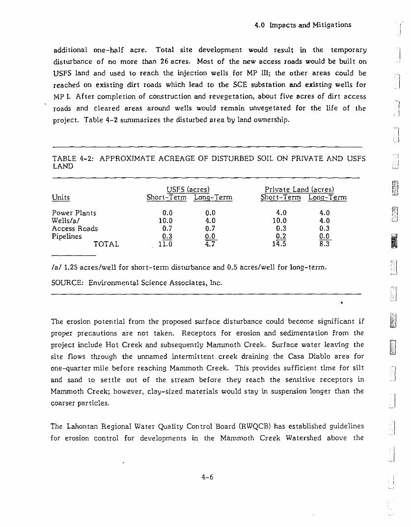
4.0 Impacts and Mitiga tions
additional one-half acre. Total site development would result in the temporary
disturbance of no more than 26 acres. Most of the new access roads would be built on
USFS land and used to reach the injection wells for MP Ill; the other areas could be --I
reached on existing dirt roads which lead to the SCE substation and existing wells for
MP I. After completion of construction and revegetation, about five acres of dirt access
roads and cleared areas around wells would remain unvegetated for the life of the -Iproject. Table 4-2 summarizes the disturbed area by land ownership.
]TABLE 4-2: APPROXIMATE ACREAGE OF DISTURBED SOIL ON PRIVATE AND USFSLAND
UnitsUSFS (acres)
Short-Term Long-TermPriva te Land (acres)
Short-Term Long-Term
Power PlantsWells/a/Access RoadsPipelines
TOTAL
0.010.00.70.3
11.0
0.04.00.70.04.7
4.010.00.30.2
14.5
4.04.00.30.08.3 I
/a/ 1.25 acres/well for short-term disturbance and 0.5 acres/well for long-term.
SOURCE: Environmental Science Associates, Inc.
The erosion potential from the proposed surface disturbance could become significant if
proper precautions are not taken. Receptors for erosion and sedimenta tion from the
project include Hot Creek and subsequently Mammoth Creek. Surface water leaving the
site flows through the unnamed intermittent creek draining the Casa Diablo area for
one--quarter mile before reaching Mammoth Creek. This provides sufficient time for silt
and sand to settle out of the stream before they reach the sensitive receptors in
Mammoth Creek; however, clay-sized materials would stay in suspension longer than the
coarser particles. . J
The Lahontan Regional Water Quality Control Board (RWQCB) has established guidelines Jfor erosion control for developments in the Mammoth Creek Watershed above the
.J4-6
iII:
]
]
I
4.0 Impacts and Mitigations
7,OOO-foot elevation. (The MP II & 1Il site lies at an elevation of approximately 7,200 to
7,400 feet.) These guidelines require a report of waste discharge from developers for
commercial developments disturbing more than one-quarter acre of land. The RWQCB
would then establish waste discharge requirements to ensure that proper control measures
for t1;le protection of water quality are taken during all phases of the proposed
development. In sa tisfying these requirements, potential impacts from erosion can be
greatly reduced. The impact is extremely difficult to eliminate completely since erosion
control measures sometimes require a period of time to become effective (WESTEC, 1986).
Mitigation Measures Proposed as Part of the Project:
During production and injection field drilling and testing activities, well sites would
be bermed to contain minor spills on location. Sites would be graded to direct runoff
to sedimentation basins or the mud/reserve pit.
The power plant site would be diked and drained to a permanent catch basin to
collect plant site runoff. The catch basin would also serve as an emergency
containment basin in the event of a significant geothermal fluid system upset or spill.
'] Mitigation Measures Required by the RWQCB: The applicant would prepare a report to be
submitted to the RWQCB incorporating the following measures, as appropriate to reduce
the impacts from erosion and sedimentation.,0
Drainage collection, retention, and infiltration facilities shall be constructed and
maintained to prevent the transport of runoff from a 20-year, one-hour design storm
from the project site. (The 20-year, one-hour design storm for the Mammoth Lakes
area is equal to 1.0 inch).
Surplus or waste material shall not be placed in drainage ways or within the 100-year
floodplain or surface wa ters.
All loose piles of soil, silt, clay, sand, debris, or earthen materials shall be protected
in a reasonable manner to prevent any discharge to state waters.
4-7
4.0 Impacts and Mitiga tions
Dewa tering shall be done in a manner so as to prevent the discharge of earthen
rna terial from the site.
All disturbed areas shall be stabilized by appropriate soil stabilization measures as
soon as possible. A specific plan for the stabilization of soils disturbed by project
activities should be completed prior to construction.
All work performed between October 15 and May 1 of each year shall be conducted in
such a manner that the project can be winterized within 48 hours.
Where possible, existing drainage patterns shall not be significantly modified.
After completion of a construction project, all surplus or waste earthen material
shall be removed from the site and deposited at a legal point of disposal.
Drainage swales disturbed by construction activities shall be stabilized by the
addition of crushed rock or riprap as necessary or other appropriate stabilization
methods.
All nonponstruction areas shall be protected by fencing or other means to prevent
unnecessary disturbance.
During construction, temporary erosion control facilities (e.g., impermeable' dikes,
filter fences, hay bales, etc.) shall be used as necessary to prevent discharge of
earthen material from the site during periods of precipitation or runoff.
Revegetated areas shall be continually maintained in order to assure adequate growth
and root development. Physical erosion control facilities shall be placed on a routine
maintenance and inspection program to provide continued erosion control integrity.
Where construction activities involve crossing and or alteration of a stream channel,
such activities shall be timed to occur during the period in which streamflow is
expected to be lowest for the year.
4-8
]
I
I
j
JJ
j
-,I
il
r
I]
j
4.0 hnpacts and Mi tiga tions
Mitigation Measures Recommended by This Report:
Construct all roads to USFS standards.
New access roads to injection wells MPI 42-32, MPI 42A-32, MPI 42B-32, and MPI
42C-32 should follow the contour of the hillside, where feasible, so that erosion from
new road surfaces would be lessened. (The botanically sensitive rhyolite buckwh~at
scrub in the area should also be avoided by the access roads.)
No more than one-quarter acre of disturbed soil unprotected by physical erosion
control facilities should be allowed at anyone time. When one-quarter acre has been
graded or cleared, the erosion control measures should be in place before additional
surface disturbance is allowed.
Stockpile soil from areas scheduled for grading or areas in which soil would be
severely compacted. The soil could then be used during revege ta tion.
4.1.1.2 Water Quality and Hydrology
This section is summarized from the separate report on hydrology available from the
Mono County Energy Management Department. The discussion covers three major types
of environmental consequences due to increased production of geothermal fluid at Casa
Diablo: 1) Degradation of surface water quality; 2) depletion of shallow' fresh
groundwater; and, 3) potential reductions in thermal spring flow or temperature.
4.1.1.2.1 Surface Water Quality
hnpact: Spills of geothermal fluid resulting from a large pipeline rupture would be the
most serious potential event. If a large pipeline carrying the entire plant capacity of
geothermal fluid (approximately 5,000 gpmat 335°F) ruptured, a loss of several thousand
gallons could result even as various pumps are automatically shut off. This includes
spillage from pipes located up-gradient of the broken line which could drain out. If the
breakage occurred on the site of the power plants, the spilled fluid would be contained by
a system of dikes and a catchment basin. Outside the plant site, the fluid would flow into
4-9

4.0 Impacts and Mitigations
the eXlStmg unnamed streambed and subsequently into Mammoth Creek. The amount of
spilled geothennal fluid tha t would reach the creek during such a spill is difficult to
predict. Approximately 15% would discharge from the broken pipe as steam. Further
reduction in volume would occur due to evaporation and infiltration into soils. The
temperature of fluid from a burst pipeline would drop to approximately 200°F upon
discharge from the open pipe due to a reduction to atmospheric pressure. Additional
temperature losses would occur as the fluid flowed over the ground surface.
Temperature effects, though likely to be short-term, would be the most significant
impact. The chemical content of the spilled geothermal fluid could cause short-term
changes to creek water chemistry, but the precise concentration would be difficult to
estimate. The chemical content of the fluid is low in Total Dissolved Solids (TDS) and
would not likely have a significant impact for a short term event. Approximately 760 gpm
of fluid from Casa Diablo wells was purposely directed to the creeks for 39 days in 1962
by a fonner operator. While this caused concern about effects of long term discharge and
potential buildup of trace elements in the potable water supply at Crowley Lake, no
catastrophic or lasting effects to the creeks or lake were documented (CDWR, 1967 and
1973; Setmire, 1984).
Similarly, a well blowout, though very unlikely, could result in a loss of drilling fluid and
200 to 500 gpm of geothermal fluid. The potential for creek contamination from loss of
drilling fluid, such as from a pit or tank, would probably not result in any significant
increase in temperature to Mammoth or Hot Creeks. Since no use of toxic addi titles for
drilling is proposed, the only potential impact to creek waters would be a short period of
turbid flow during the disper~:l of the drilling fluid. Any residual fluid or solids remaining
on the ground surface would be removed during cleanup opera tions and should not result in
environmental damage. A blowout would probably have less impact than accidental
thennal fluid discharge.
Mitigation Measures Proposed as Part of the Project:
A detailed blowout contingency plan will be developed, including blowout prevention
equipment required during drilling. In addition, at least 10,000 gallons of cold water
would be stored on the well site to quench the well should a blowout occur during
drilling. At least 50,000 gallons would be available during power plant operation.
4-10
I]
JJ
J
Ij
i
j:
4.0 Impacts and Mitigations
Regular testing and maintenance of automatic pump shutdown system would allow
proper operation of equipment to prevent large scale spills of geothermal fluid due to
pipeline rupture.
Containment dikes and ca tchment basins should be adequa tely maintained to prevent
erosion.
Impacts: Surface water could be contaminated by runoff from soils previously
contaminated by leakage or spills of fuels and other chemical compounds used on the site.
The potential for the latter is more likely during well drilling and power plant
construction phases due to the presence of machinery, fuels and chemical compounds that
would be stored and used on site.
Mitigation Proposed as Part of the Project:
Mitigation measures for various spills and a detailed spill contingency plan would
include inunedia te removal of spilled fluid by pump trucks for proper disposal,
building containment dikes with heavy equipment, and removal of contaminated
soils. Cleanup is to begin immedia tely along with notification of appropria te public
agencies.
] MitiRa tion:
Follow RWQCB requirements for storage of hazardous materials.
..
Regular site maintenance, cleanup, vehicle maintenance, and proper storage and
handling of potentially hazardous materials should prevent significant contamination
of soils or surface runoff.
4.1.1.2.2. Shallow Fresh Groundwater
Impacts: It is unlikely that any significant influence on shallow groundwaters in nearby
areas will result since the particular aquifer from which shallow fresh water is produced is
probably limited to the Casa Diablo area. No connection is believed to exist between this
groundwater aquifer and the more extensive shallow groundwaters in the south caldera
area, for example, along the course of Mammoth Creek.
4-11

4.0 Impacts and Mitigations
Mi tiga tion:
None is necessary.
4.1.1.2.3 Hydrothermal Resources
Potential impacts of geothermal power production on surface thermal fluid resources
(springs and other manifestations) near Casa Diablo are difficult to assess without a more
thorough understanding of the geothermal. reservoir. Without accurate estimates of
reservoir permeability, storag", potential recharge and regional fluid movement no
ac=ate prediction of consequences of development of MP II & III can be made. Even less
is known about potential thermal reservoirs or the source of fluid for the Hot Creek Gorge
and Hot Creek Hatchery areas. More detailed reservoir characterization would assist in
calculating or estimating potential adverse effects on springs. Potential effects could be
estimated only if hydraulic connection between the geothermal reservoir at Casa Diablo
and the source of the springs is established.
Two distinctly different models of subsurface thermal fluid ongms and flow directions
have emerged as discussed in the Affected Environment. The Upwelling/Fracture Flow
Model implies that there is no hydraulic communication between the Casa Diablo area and
the Hot Creek Hatchery and Hot Creek Gorge area, which in effect precludes potential
adverse impacts. The Lateral Flow Model suggests relatively widespread lateral hJtdraulic
communica tion in the south and southwest caldera region in one or more zones. The
latter model allows consideration of the potential adverse impacts to hot springs which
could result from continued or increased production and injection of geothermal fluids.
Simulated Reservoir Performance Calculations
I
I
Two different methods were used to estimate the effects of production and injection on
nearby springs under the assumption that hydraulic communication does exist. Both were
based on highly simplified models. The first uses a computer model which simulates a Jreservoir with no discontinuities or barriers and with uniform characteristics in all
directions. This model was used to estimate the pressure changes (water level changes) in
4-12
j
I:]i
I]
j
4.0 Impacts and Mitigations
the hydrothermal reservoir corresponding to surface locations of interest. The second
calculation was used to predict the distance that cooler, injected fluid would move
outward from Casa Diablo.
Pressure Response Modeling
The computer model used for the calculations presented below has been successfully
applied to predict pressure behavior in other fractured geothermal reservoirs and is used
here to provide a quantitative analysis of production and injection at Casa Diablo under
the following simplifying assumptions:
la teral flow is uniform;
there is no hot water recharge to the producing reservoir; and
there is complete hydraulic communication between injection and production zones.
Computer calculations were run for two different values of the reservoir permeability
thickness product (kh) of kh = 150,000 md-ft and 500,000 md- ft./ll This parameter is the
product of average reservoir permeability and average reservoir height. It is a measure of
how much pressure drop wi]; occur for known, net flow out 0' the reservoir. These values
constitute approximate upper and lower bounds based on previous work (GeothermEx,•
1986), and provide a reasonable range of values for the subsurface fractured rock in this
area of the caldera.
First, production from three MP I wells totalling 3,800 gpm at 335°F with 100'7. injection
was assumed. A simula tion was performed which included the additional
production/injection for MP II & 1111 (approximately 10,000 gpm) beginning in 1988. For all
calculations discussed, power plant operations were assumed to begin in early 1985 for
MP I and mid-1988 for MP II & III. The computer calculated the reservoir pressure
response for the areas underlying Colton Spring (CS), Shady Rest (SR), Hot Creek
Hatchery (FH) and Hot Creek Gorge (HCG) over several years, after MP I startup.
The model does not predict the relationship between the calculated reservoir pressure
changes and the actual effect on the surface features.
4-13
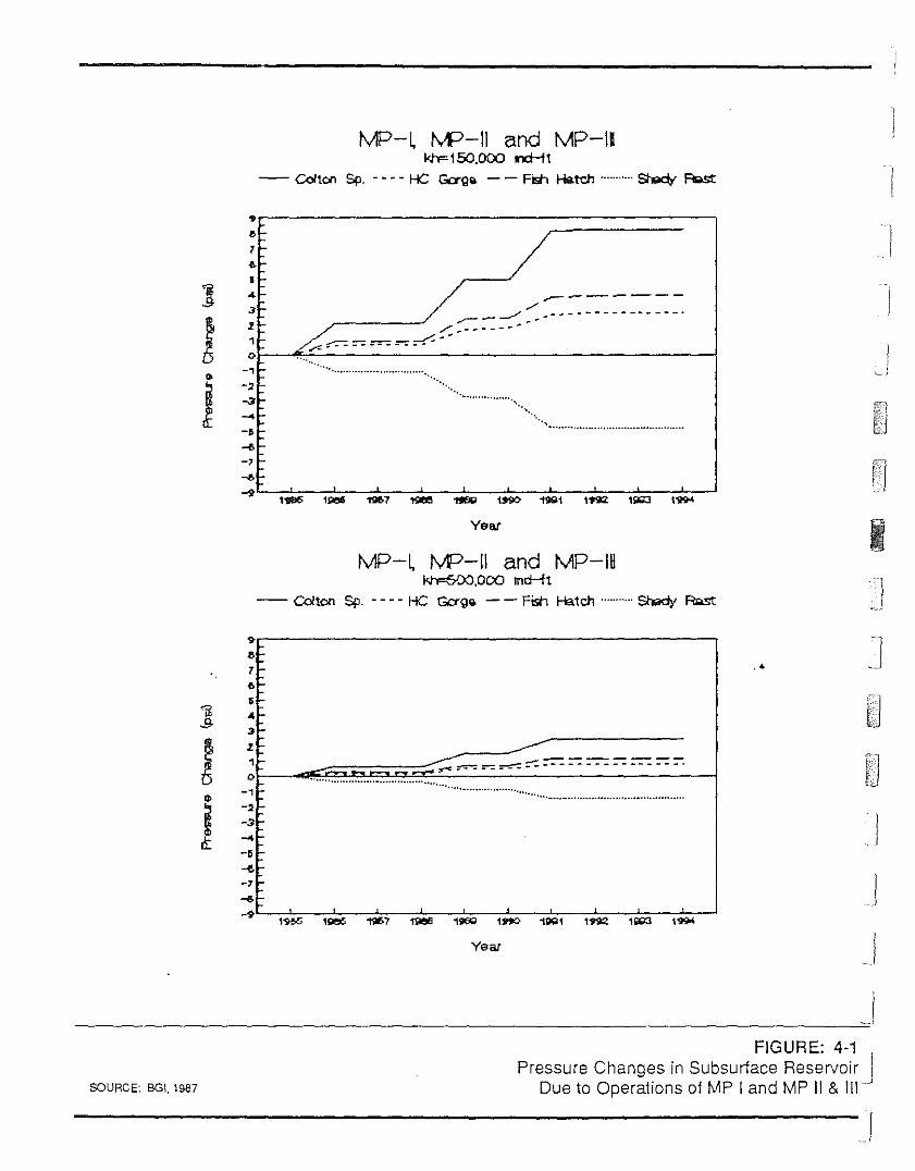
1'vIP-I. 1'vP-1i and MP-Ilkh=150.000 ncHt
-- Colton Sp. - - - - He Gag" - - Fistl Hatcl1 SI'9cIt Fl<>st
I
MP-l IVP-II and MP-IHkrF6OO.000 md-'ft
-- Colton Sp. - - - - He Gall" - - Fistl Hatch ShIildy RQst
,I>f-1~
•] ...3t-
! If-,0.. -,
j -~ f-~f-
-4-, '-~'--, ,..-..-'9
.--------./.......----'""" , .... - ... ------------_.
/ ~ =-= ..---_.=-: ~::: ... - .. - -_ ....
.................................
_ .".
'~"
".
Year I
"I>1~,..,
~ ....s :>
~I-,0.. -,
i -~ --3
i\: -4-, -~
-,.....-'9
1905
..................................... -...........•...........•...............
,
Year
.'
II
.1
SCURCE: BGI. 1SS7
FIGURE: 4-1
preDssurte Cohan9tes in SjUMbSpUrfl
acde MRepsellrv&o,i,r, Jue opera Ions ° an
j
1j
j,
I
I
4.0 Impacts and Mitiga tions
The results, shown in Figure 4-1, indicate that the 100% injection of produced fluids on
the east side of Casa Diablo prevents pressure in the reservoir from declining at the Hot
Creek Hatchery or Hot Creek Gorge area. However, pressure drawdown would be
predicted fe;; the reservoir beneath Casa Diablo Geyser, which is close to the center of
production. Slight decreases in reservoir pressure are predicted for the Shady Rest Well
area. The model indicates most subsurface pressure effects will occur in the first few
years of power plant operation with only slight pressure changes occurring at later times.
This effect is due primarily to 100% injection of produced fluid. The calculation using
kh=500,OOO md-ft is believed to be closer to the probable value than 150,000 md-ft. The
higher kh value gives lower effects (in the reservoir) due to power plant operations. The
results of the calculations for the kh=500,OOO md-ft case are more consistent with the
apparent low reservoir drawdowns presently observed in the existing MP I wells and the
continued, though declining, Casa Diablo spring flow. Based on experience in other
geothermally active areas, this value of kh is relatively large, but not unreasonable for
pervasively fractured volcanic rock.
Any combination of effects not accounted for in this model could significantly affect
potential reservoir pressure responses. For example, natural subsurface recharge of hot
water to the reservoir could reduce the magnitude of calculated pressure changes. It is
also possible that reservoir pressure could increase if free movement of fluid occurs
between production and injection zones. However, barriers to the movement of fluid
could increase calcula ted drawdowns..<
No attempt was made to calcula te the pressure changes beyond nine years since the model
is at best a rough estima te due to lack of available data. If calcula tions were extended
for the full 30-year power plant life, no significant change in the results would be
predicted unless other geothermal power plants were to be constructed.
As mentioned previously, no precise relationship between spring flow rate and the
reservoir pressure is known. Hence, predicted reservoir pressure changes cannot be
interpreted directly as increases and decreases in spring flow. The location of boiling and
condensation in the subsurface would need to be modeled in detail for a realistic appraisal
of the rela tionship.
4-15
4.0 Impacts and Mi tiga tions
Bulk Model Calcula tion
A second calculation was perfonned in an attempt to estimate the distance that the
cooler injected fluid would move from Casa Diablo and therefore, predict the potential
for interference of cooler injected fluid with hot regions beneath springs. This so-called
"bulk-model" calculation is ba5ed on assumptions of rock thennal properties, porosity, and
displacement of fluid outward in an approximately u,..ifonn cylindrical front. An injection
fluid temperature of 300°F and a reservoir thickness of 500 feet were also assumed.
Continuous injection of 3,800 gpm for MP 1 and 10,000 gpm for MP 11 & 111 was assumed.
The hydrodynamic front would expand outward at a faster rate than the thermal front.
The calculated position of the thermal front indicates that the distance cooled fluid
moves away from the injection wells is approximately 1,400 feet in 30 years.
This calculation in simplistic, but useful for comparison with other models. In reality,
fractured rock could allow preferred flow paths to carry injected fluid far beyond the
calculated fronts. However, results indicate that a very large distortion of the calculated
front would be required for the lower temperature fluid to travel as far as Hot Creek
Hatchery (approximately three miles distant) or Hot Creek Gorge (about five miles). It is
also significant that gravity segregation has not been accounted for in this calculation.
This effect allows colder fluid to sink deeper into the reservoir, decreasing the probability
of near surface consequences. Gravity segregation models have been used to study other..reservoirs and could be studied in more detail as new data on the reservoirs become
available. The assumed porosity of five percent may be high for fractured rock, but no
estimates of porosity at Casa Diablo are currently available. The reservoir thickness of
500 feet may be low based on some geological evidence. These two parameters, porosity
and reservoir thickness, have compensating effects in the calculations, and using slightly
different values should not alter the conclusions given below. It is possible that the
effective injection zone thickness is greater than the 500 feet assumed for this
calculation. This could allow a decrease in the radial extent of the hydrodynamic and
thermal fron ts.
A separate calculation related to distortion of the bulk model thermal front was
performed. It is based only on the subsurface hydraulic gradient which may induce lateral
4-16
I
I
Ij

I,
']1r
-II
11
1'j
]
I)
Ij
4.0 Impacts and Mitigations
west to east flow. The effect of this gradient would be to allow greater movement of the
injected fluid down-gradient to the east and is not accounted for in the bulk model. As
previously mentioned, there is some debate as to whether such a lateral west-to-east flow
exists. Assuming it does exist for the purpose of estima ting a worst case scenario, a
rough estimate of its effect can be calculated from the regional groundwater gradient. A
fluid velocity of 0.06 ft/day was calculated based on a horizontal permeability
corresponding to kh= 500,000 md-ft. used in the computer model and a value for the local
groundwater gradient map of 0.0135 ft., estimated from the water level contour map of
Farrar et al. (1985).
The results indicate that fluid moving from Casa Diablo would take about 100 years to
reach Hot Creek Hatchery and 150 years to reach Hot Creek Gorge. These results are
based on the assumption that lateral west-to-east subsurface flow occurs in the region
and no provision is made for the effect of preferred f10t paths, which are often associated
with fractured reservoirs. However, calculations of the movement of fluid in the
subsurface induced by the local groundwater gradient does not take into account reheating
of injected fluid through contact with hot reservoir rock.
If reinjected fluids reach the subsurface zones below the surface springs, it may not
necessarily result in the cooling of springs or in decreasing f1owrates. This could delay
the arrival up to 10 times of the cooler winter as illustrated in the bulk model. The
estimated position of the thermal front including some distortion by lateral flow indicates•breakthrough of cool injection fluid is not likely to be a potential threat to 'existing
springs.
Impacts: It is difficult to predict the effects on surface thermal features resulting from
production/injection operations at the proposed project and the existing MP I power
plant. The simple model calcula tions described here indica te tha t, assuming hydraulic
communication exists, the potential for subsurface impacts to extend three to five miles
to Hot Creek Hatchery and Hot Creek Gorge is very low. Also, subsurface effects may
not be related directly to thermal springs. Special circumstances exist at each area, such
as those at the hatchery springs, where it is estimated that less than five percent of the
flow is thermal water. The temperature of the thermal fluid component of these springs
is unknown, hence it can only be estimated that a loss of the entire thermal component
4-17
4.0 Impacts and Mi tiga tions
could result in a lowering of average spring temperatures by 2° to 3°C (Sorey, 1987a).
nus effect cannot be considered a certainty, however. Only continued monitoring of
springs and wells may allow cause and effect relationships to be established.
Mitiga tion:
Since a precise analysis of hydrologic effects due to increased geothermal development at
Casa Diablo is not possible on the basis of current data, a closely controlled program of
surface and subsurface fluid monitoring should be established. This program should
include measurement of chemistry, f10wrate and temperature of important surface
features; temperature, pressure and, flow rate and chemistry of one or more observation
wells; injection well pressure; and production well temperature, pressure, f10wrate and
chemistry. Well test data collected during the development of the wellfields for power
plants is usually confidential, but could be made available to an appropriate agency for
review. Continuous monitoring and periodic sampling of various features is already
underway by the USGS and others (Farrar et aI., 1985 and 1986). A similar though less
comprehensive program is likely to be proposed by Mammoth Pacific. Table 4-3 lists the
monitoring activities that have been proposed and those recommended by this study.
The proposal includes a significant upgrade in the accuracy of downhole pressure
measurement during testing and production of wells, which should result in more accurate
estimates of reservoir parameters than presently available. This and other p,roposed
monitoring should allow the application of more detailed models than the simplified
versions used for calculations in this study. Calculations may then be upgraded and
improved, and potential adverse consequences to the reservoir and/or springs can be
reevaluated periodically.
I
It is recommended that a monitoring well be drilled at an accessible and permissable
location chosen by an appropriate agency. A suggested location for this well would be
between the County buildings and Well M-l. The primary function of the monitorins well
would be to serve as early warning of reservoir pressure decreases or temperature Jdecreases which may affect springs propagating toward the east or southeast. Without
this means of detection, it may take several years for adverse impacts to be defined b:J Jmeasurements at the springs themselves.
.1
4-18J
J
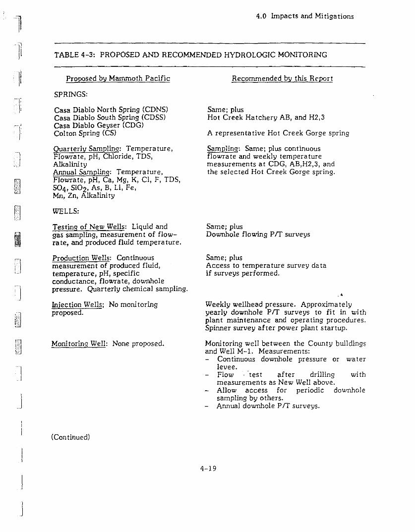
TABLE 4-3: PROPOSED AND RECOMMENDED HYDROLOGIC MONITORING
4.0 Impacts and Mitigations
I
j
J
]
I
II
Proposed by Mammoth Pacific
SPRINGS:
Casa Diablo North Spring (CONS)Casa Diablo South Spring (CDSS)Casa Diablo Geyser (COG)Col ton Spring (CS)
Quarterly Sampling: Tempera ture,Flowrate, pH, Chloride, TDS,AlkalinityAnnual Sampling: Temperature,Flowrate, pH, Ca, Mg, K, cr, F, TDS,504, Si02, As, B, Li, Fe,Mn, Zn, Alkalini ty
WELLS:
Testing of New Wells: Liquid andgas sampling, measurement of flowrate, and produced fluid temperature.
Production Wells: Continuousmeasurement of produced fluid,temperature, pH, specificconductance, flowrate, downholepressure. Quarterly chemical sampling.
Injection Wells; No monitoringproposed.
Monitoring Well: None proposed.
(Continued)
Recommended by this Report
Same; plusHot Creek Hatchery AB, and H2,3
A representative Hot Creek Gorge spring
Sampling: Same; plus continuousflowra te and weekly tempera turemeasurements at COG, AB,H2,3, andthe selected Hot Creek Gorge spring.
Same; plusDownhole flowing prr surveys
Same; plusAccess to tempera ture survey da taif surveys performed.
.'Weekly wellhead pressure. Approximatelyyearly downhole prr surveys to fit in withplant maintenance and operating procedures.Spinner survey after power plant startup.
Monitoring well between the County buildingsand Well M-l. Measurements:
Continuous downhole pressure or waterlevee.Flow test after drilling wi thmeasurements as New Well above.
- Allow access for periodic downholesampling by others.Annual downhole Prr surveys.
4-19

Other: None proposed.
Proposed by Mammoth Pacific
TABLE 4-3:(Continued)
PROPOSED AND
4.0 Impacts and Mitigations
RECOMMENDED HYDROLOGIC MONITORING
Recommended by this Report
Annual downhole temperature surveys inChance #2 or similar nearby well. Begincontinuous water level or downhole pressuremonitoring if significant changes are seen inabove-mentioned monitoring well (ifpermissable and if no Mammoth Chanceproject proceeds).
)
I-J
. )
JSOURCE: Berkely Group Incorporated, 1987.
If properly sited, the monitoring well could more precisely detect changes in subsurface
conditions propagating toward Hot Creek Hatchery and Hot Creek Gorge than may be
possible by surface spring sampling and flowrate measurements. Locating an ideal site
may be difficult given the variable geologic structure in the region and potential limits on
property access. Given these constraints, there is no guarantee that such a well would be
in hydraulic communication with either production or injection zones at Casa Diablo or
fluids supplying surface springs of interest.,6
Also recommended are periodic temperature measurements in a deep well or wells near
the Hot Bubbling Pool, such as Chance #2. This would have to be arranged with current
well owners and would depend upon the status of the Mammoth/Chance project.
Existing background data collection should be continued to establish baseline values and
ranges of temperature, pressure and chemical constituents which can be agreed upon by
appropriate agencies. The data collected by the USGS and others thus far, presented by
Farrar et a!. (1985 and 1986), should allow general guidelines to be established which could
then be upda ted as new data is added. Addi tional da ta would be helpful in delinea ting
more precisely to what extent pressure, temperature, chemical and flowrate changes can
be attributed to natural causes (e.g., tectonic strain and seasonal precipitation amounts)
and what changes, if any, may be attributed to power plant operations.
4-20
I
I)
Ij
I
I n.I !Ii I
I II,I
]I
II11
TI
tI
4.0 Impacts and Mi tiga tions
If spring flows or temperatures were reduced in the Hot Creek area and it could be
established that MP II & III power plant operations were the cause, the follou,ing
mi tiga tions could be pursued.
Mi tiga tions:
Participate in a hydrologic monitoring program as required by Mono County Energy
Management Department.
Provide thermal fluid from wells to restore original baseline flows and temperatures
to the hatchery. It has been estimated that thermal water contributes no more than
5% to the flow at the hatchery, or about 450 gpm of the 9000 gpm used in hatchery
operations. If operation of the MP II & III plants caused depletion of the geothermal
resource so that hatchery operations were adversely affected, it would be possible to
increase pumping from the reservoir by less than 5% of their combined pumping ra te
and supply the hatchery with 450·gpm of thermal water. This process would mitigate
the impacts of depletion of the geothermal resource at the hatchery but would
increase slightly the impact elsewhere.
Heat water for Hot Creek Hatchery using a source of energy other than heat from
geothermal fluids. Raising the temperature of the water used at the hatchery by
conventional heating methods would be expensive. This is not likely to be a feasible.4
mitigation. See the notes to Section 4.1.3.2, Socioeconomics, for a calculation of the
cost.
Supply geothermal water from a well to Hot Creek Gorge. At Hot Creek Gorge,
wellhead and pipeline outflow could be constructed in such a manner as to be
relatively inconspicuous, but such measures would not restore the scenic value and
visitor appeal as it currently exists. Therefore, it is not a realistic mitigation for
preseniatioh of the recrea tional value of Hot Creek Gorge.
MP II & III power plant operations could be reduced or stopped. Reducing or stopping
the pumping of geothermal water at the power plant is not likely to result in
immedia te restoration of spring flow to background levels a t springs which may be
affected because of the time required for the system to recover.
4-21
4.0 Impacts and Mitigations
NOTES - Hydrothermal Resources
/1/ The reservoir permeability thickness product is the average reservoir permeability,me ~sured in millidarcies, multiplied by the thickness of the reservoir, measured infeet. A millidarcy is one-thousandth of one darcy, which is a standard unit of /'permeabili ty equivalent to the passage of one cubic centimeter of fluid of onecentipoise viscosity flowilcg in one second under a pressure differential of oneatmosphere through a porous medium having an area of cross-section of one squarecentimeter and a length of one centimeter. l'
4.1.1.3 Noise
Three phases of the proposed MP Il and III projects would generate noise in the vicinity of
the Casa Diablo Hot Springs: cOllstruction, well-drilling and testing, and operations.
4.1.1.3.1 Construction Noise
Impacts: Noise from construction-related activities consists of both noise from heavy
machinery used at the site and noise from transporting equipment and workers to and
from the site. Construction of each of the MP Il and III facilities would last about nine
months, with no overlap of construction periods. During construction, heavy equipment
would generate noise levels similar to those shown in Table 4-4. Occasional recreational
users of adjacent forest as well as wildlife in the area may be affected by these
temporary noise levels depending on topography and vegetation. Given existing
topography and vegetation, noise from construction activities at the project site are not
expected to impact any existing sensitive receptors. The peak noise level of 89 dB", Leq,
due to excavation (at 50 feet) would be attenuated by distance alone to 47 dBA, Leq, at
the closest sensitive receptors; the County office buildings 1.25 miles to the east. Given
existing topography and vegetation, noise from construction activities is not expected to
impact any sensitive receptors such as schools, hospitals, churches, or libraries.
Mi tiga tion:
Use muffling devices on construction equipment. Optimal muffler design can reduce
noise levels from diesel-powered earthmo\'ing equipment by up to 10 dBA (Schomer
et aI., 1976).
4-22
I
]
j
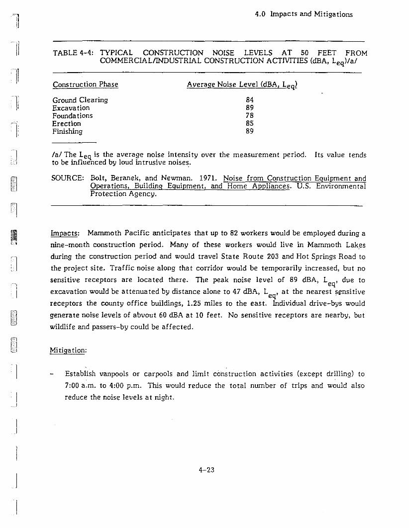
4.0 Impacts and Mitigations
TABLE 4-4: TYPICAL CONSTRUCTION NOISE LEVELS AT 50 FEET FROMCOMMERClALIINDUSTRlAL CONSTRUCTION ACTTVITIES (dBA, Leq)/al
Ii
11
]J
Construction Phase
Ground ClearingExcavationFounda tionsErectionFinishing
Average Noise Level (dBA, Leq~
8489788589
lal The Leq is the average noise intensity over the measurement period. Its value tendsto be influenced by loud intrusive noises.
SOURCE: Bolt, Beranek, and Newman. 1971. Noise from Construction Equipment andOperations, Building Equipment, and Home Appliances. U.S. EnvironmentalProtection Agency.
Impacts: Manunoth Pacific anticipates that up to 82 workers would be employed during a
nine-month construction period. Many of these workers would live in Manunoth Lak,es
during the construction period and would travel State Route 203 and Hot Springs Road to
the project site. Traffic noise along that corridor would be temporarily increased, but no
sensitive receptors are located there. The peak noise level of 89 dBA, Leq, due to
excavation would be attenuated by distance alone to 47 dBA, L ,at the nearest sensitiveeq "receptors the county office buildings, 1.25 miles to the east. Individual drive-bys would
generate noise levels of abvout 60 dBA at 10 feet. No sensitive receptors are nearby, but
wildiife and passers-by could be affected.
Mi tiga tion:
Establishvanpools or carpools and limit co"nstruction activities (except drilling) to
7:00 a.m. to 4:00 p.m. This would reduce the total nwnber of trips and would also
reduce the noise levels at night.
4-23
4.0 Impacts and Mitigations
4.1.1.3.2 Well Drilling and TestingNoise]
!
Impacts: Well drilling noise results from a variety of sources including diesel engines,
mud pumps, and electric generators. Drilling equipment would be operated 24 hours per Iday for 12 to 16 days at each of sixteen planned wells. Noise levels from well drilling
have been estimated to reach 77 dBA, Leq, at 100 feet (WESTEC, 1986). It is unlikely ]
that more than one well would be drilled at anyone time, but as many as two wells may
be drilled simultaneously and noise levels as high as 80 dBA, Leq, at 100 feet could be )
produced. This noise level could be annoying to wildlife and people in the vicinity, but
would be attenuated by distance to 66 dBA, L ,at 500 feet and to approximately 44 dBA,eqL ,at the closest sensitive receptors, 1.25 mile to the east. Terrain and vegetationeqwould further attenuate these temporary noise levels.
After being drilled, each well would be cleaned out by pumping geothermal fluids out of it
for two to four hours. Cleanout would be followed by flow testing for about five days.
Noise levels from c1eanout and flow testing would probably range from 75 to 79 dBA, L ,eqat 100 feet (WESTEC. 1986). Attenuated noise levels would be similar to those described
for well drilling.
Mitiqation:
None are required beyond those n"cessary to comply with county and OSHA
regulations. The County will enforce GRO 4 noise regulations which requi1-e that
noise levels not exceed 65 dBA, Le at the lease boundary or 0.5 mile from theq,source, whichever is grea ter.
4.1.1. 3. 3 Opera tional Noise
lmpacts: Noise levels generated by the MP II & III plants would be similar to levels
generated by the existing MP I facility. Noise from the unmuffled MP I plant has been
measured at about 76 dBA, L ,at 150 feet. Noise abatement devices have been shown toeq
reduce noise levels by 10 to 12 dBA, L (Asper, 1987b). The MP II & III plants wouldeqoperate 24 hours per day, seven days per week, as does the MP I plant. Addition of two
more plants with the capacity to generate noise levels similar to those produced by the
MP I facility could result in a combined noise level four to five decibels louder than the
4-24
i
IJI

IIIJ
'11;
I
I
4.0 Impacts and Mitigations
MP I plant, a noticeable increase. Distance, topography, and vegetation would attenuate
noise from these facilities to a level below background noise levels at all sensitive
receptors identified in Section 3.1.3.
Mitigation Proposed as Part of the Project:
Noise-muffling devices are included in the design of the facili ties. They have been
shown to reduce noise levels by 10 to 12 dBA, Leq.
Mitigation:
Apply muffling devices to the MP I plant so that the background noise decreases to a
level of 65 dBA at the project boundary or at a distance of 0.5 mile, whichever is
greater.
4.1.1.4 Air Quality
The potential for geothermal resource development to adversely affect air quality exists
during plant construction; well drilling, testing, and clean out; and plant operation. In
addition, accidents may result in air pollutant emissions during any phase of development.
4.1.1.4.1 Construction.4
Impacts: Earthmoving and construction activities would generate large amounts of dust,
degrading local air quality during two separate nine-month construction periods. A large
fraction of the particulate matter generated by construction activities would settle out of
the atmosphere rapidly and would not create a public health problem or affect the air
quality of nearby Class I areas. Smaller particulate matter (PM10) would remain
suspended for a longer period of time and may create a health hazard or degrade visibility
in nearby. ·areas. Worst-case 24-hour PMl~ averages at and near the site would exceed
the state one-hour standard of 50 ug/m. Small amounts of CO, N02, 5°2, and
hydrocarbons would be produced by fuel combustion. Use of paints and asphalt would also
emit small amounts of hydrocarbons.
Air pollutant emissions generated by project development, operation, and accidents would
probably not degrade the air quality of the John Muir Wilderness. Most of the wilderness
4-25
4.0 Impacts and Mitigations
area is at elevations above 8,000 feet, while the project site is at about 7,300 feet. The
predominant westerly and northwesterly winds, along with nighttime downslope drainage,
would divert pollutants away from the wilderness area and towards Long Valley. Daytime
upslope and easterly Santa Ana winds may concentrate pollutants in the project area, but
probably would not direct pollutants to the south and upslope into the wilderness area.
Mi tiga tion:
Construction sites should be wetted down during the development period at least
twice a day, with complete coverage, and with enough water to moisten the ground
surface. This measure would reduce dust by about 50'10.
Stockpiled materials and loaded trucks should be covered to avoid wind entrainment
of dust. Trucks should not be overfilled and off-site spills should be cleaned up
promptly.
Exposed soil should be revegetated as soon as possible.
Construction should be planned so that large, unvegetated areas are not left exposed
to wind erosion for long periods. If large, unvegetated areas were exposed, solid
barriers should be used around sites to reduce the quantity of dust entrained by the
wind.•
Vehicle speeds at construction sites should be kept below 15 miles per hour, and
overall vehicle travel on construction sites should be minimized.
Water-based paints and architectural coatings should be used in place of oil-based
materials to the extent feasible in project construction.
4.1.1.4.2 Well Drilling, Cleanout, and Testing
Eight well sites have been selected for development of production wells. Well drilling
would typically require about 12 days per well, during which time criteria pollutants would
be produced by the drill rig. H2S and other noncondensable gases may be emitted
intermi ttently on a temporary basis during drilling, although H2S moni toring performed
4-26
I
)
I
IJI
~n
!i
Ii
]i
I,
]
4.0 Impacts and Mi tiga tions
during drilling and testing of the MP I wells detected no HZS emissions (Mammoth Pacific,
1986). The greatest potential for atmospheric emissions would be the occurrence of a
well "blowout" as discussed in Section 4.1.1.4.4.
~pacts: H2S may temporarily (two to four hours) be released during the c1eanout and
flow testing of wells, when geothermal fluids are pumped into large open containers. At
an operational flow rate of 2,000 gallons per minute (gpm) for pumped flow (PLES, 1986)
and a worst-case H2S content of 8 milligrams per liter (mgll) approximately 3.6 kg/hr of
H2S could be emitted from the containers. Such emissions would exceed the APeD H
2S
emissions standard of 2.5 kg/hr/source.
The EPA-approved dispersion model PTPLU was used to estimate worst-case ground-level
concentrations from this H2S emission rate. To do this, several assumptions were made
(see Table 4-5). Under these assumptions, estimated ground-level H2S concentrations
range from 0.1 to 4.1 parts per million (ppm) as shown in Table 4-6. These concentrations
cover a range of stability conditions and wind speeds. The higher H2S concentrations
would occur during moderately stable to moderately unstable atmospheric conditions, at
wind speeds ranging from 10 to 12 mph, conditions typical of the project area. These H2S
concentrations would exceed the state one-hour standard of 0.03 ppm, and would produce
a noticeable "rotten egg" odor; they would not pose a health hazard and would not reach
beyond the immediate vicinity of the well under normal conditions.
Mitigation:.4
Limit drilling, c1eanout, and testing activities to one well at a time. This measure
would help prevent H2S concentrations that could exceed county and state standards
established to protect public health.
4.1.1.4~3 Operations
Impacts: After the initial c1eanout and flow testing, all geothermal and working fluids
would be contained in closed systems (emissions from potential accidents are discussed in
Section 4.1.1.4.4). Geothermal fluids would not be exposed to the atmosphere at any time
during normal operations. The isobutane working fluid would also circulate in a sealed
system except during system charging, when isobutane may be released to the
4-27
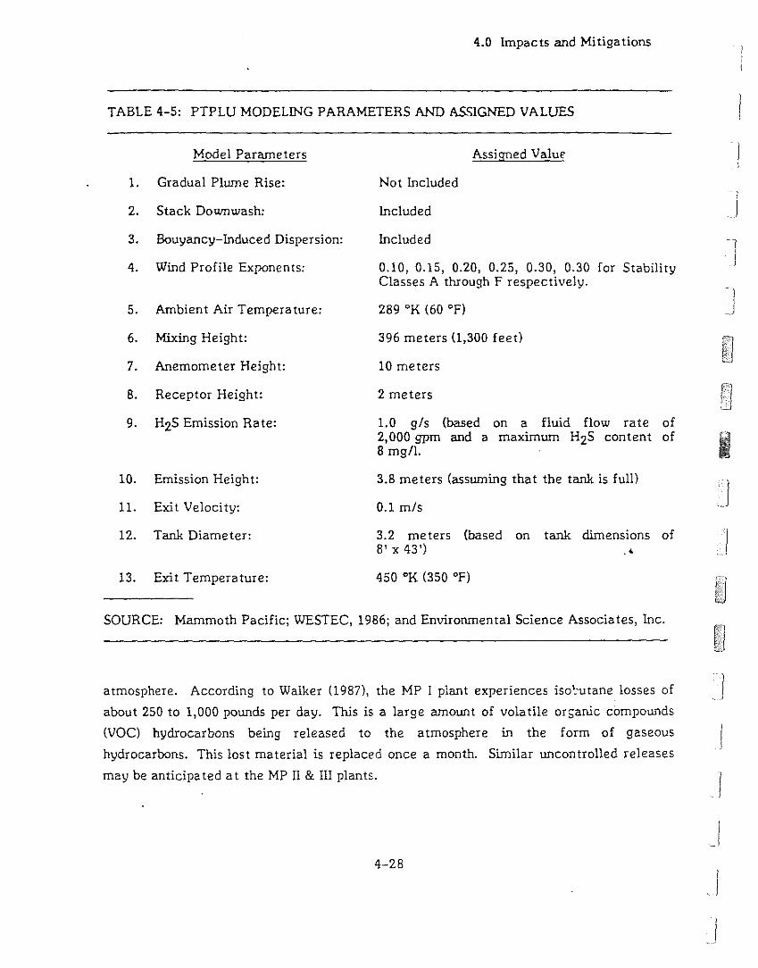
4.0 Impac ts and Mitiga tions
TABLE 4-5: PTPLU MODELING PARAMETERS AND ASSIGNED VALUES
Model Parameters
1. Gradual Plwne Rise:
2. Stack Downwash:
3. Bouyancy-Induced Dispersion:
4. Wind Profile Exponents:
5. Ambient Air Temperature:
6. Mixing Height:
7. Anemometer Height:
8. Receptor Height:
9. H2S Emission Rate:
10. Emission Height:
11. Exit Velocity:
12. Tank Diameter:
13. Exit Temperature:
Assigned Value
Not Included
Included
Included
0.10, 0.15, 0.20, 0.25, 0.30, 0.30 for StabilityClasses A through F respectively.
289 oK (60 OF)
396 meters (1,300 feet)
10 meters
2 meters
1.0 g/s (based on a fluid flow rate of2,000 gpm and a maximwn H2S content of8 mg/1.
3.8 meters (asswning that the tank is full)
0.1 m/s
3.2 meters (based on tank dimensions of8'x43') •
450 OK (350 OF)
IIj
I]
I
I
SOURCE: Mammoth Pacific; WESTEC, 1986; and Environmental Science Associates, Inc.
atmosphere. According to Walker (1987), the MP I plant experiences iso'.'utane losses of!
about 250 to 1,000 pounds per day. This is a large amount of volatile orsanic compounds
(VOC) hydrocarbons being released to the atmosphere in the form of gaseous Jhydrocarbons. This lost material is replaced once a month. Similar uncontrolled releases
may be anticipa ted at the MP II & III plants.
4-28
I
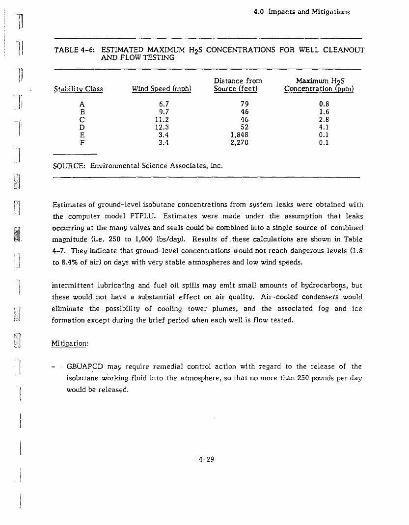
Ii
]i
l)
]
j
4.0 Impacts and Mi tiga tions
TABLE 4-6: ESTIMATED MAXIMUM H2S CONCENTRATIONS FOR WELL CLEANOUTAND FLOW TESTING
Distance from Maximwn H SStability Class Wind Speed (mph) Source (feet) Concentration GJpm)
A 6.7 79 0.8B 9.7 46 1.6C 11.2 46 2.8D 12.3 52 4.1E 3.4 1,848 0.1F 3.4 2,270 0.1
SOURCE: Environmental Science Associates, Inc.
Estimates of ground-level isobutane concentrations from system leaks were obtained with
the computer model PTPLU. Estimates were made under the asswnption that leaks
occurring at the many valves and seals could be combined into a single source of combined
magnitude (i.e. 250 to 1,000 lbs/day). Results of these calculations are shown in Table
4-7. They indicate that ground-level concentrations would not reach dangerous levels (1.8
to 8.4% of air) on days with very stable atmospheres and low wind speeds.
intermittent lubricating and fuel oil spills may emit small amounts of hydrocarbons, but.'
these would not have a substantial effect on air quality. Air-cooled condensers would
elimlnate the possibili ty of cooling tower plwnes, and the associa ted fog and ice
formation except during the brief period when each well is flow tested.
Mitiga tion:
GBUAPCD may require remedial control action with regard to the release of the
isobutane working fluid into the atmosphere, so that no more than 250 pounds per day
would be released.
4-29
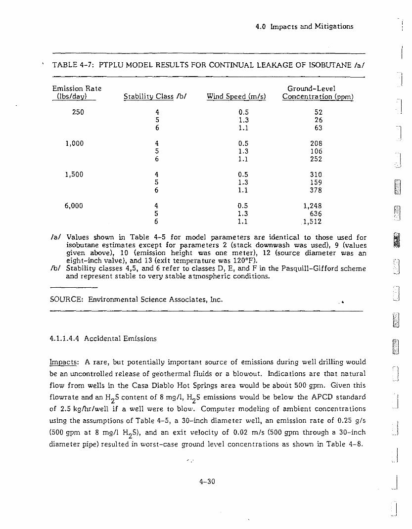
4.0 Impacts and Mitigations
TABLE 4-7: PTPLU MODEL RESULTS FOR CONTINUAL LEAKAGE OF lSOBUTANE lal
Emission Rate(lbs/day)
250
1,000
1,500
6,000
Ground-LevelStabili ty Class fbI Wind Speed (m/s) Concentration (ppm)
]4 0.5 52 J
5 1.3 266 1.1 63
4 0.5 2085 1.3 1066 1.1 252
4 0.5 3105 1.3 1596 1.1 378
4 0.5 1,2485 1.3 6366 1.1 1,512
lal Values shown in Table 4-5 for model parameters are identical to those used for 1iIiI.-
isobutane estimates except for parameters 2 (stack downwash was used), 9 (values IIgiven above), 10 (emission height was one meter), 12 (source diameter was aneight-inch valve), and 13 (exit temperature was 120°F).
fbI Stability classes 4,5, and 6 refer to classes D, E, and F in the Pasquill-Gifford schemeand represent stable to very stable atmospheric conditions.
SOURCE: Environmental Science Associates, Inc.
4.1.1.4.4 Accidental Emissions
.<
Impacts: A rare, but potentially important source of emissions during well drilling would
be an uncontrolled release of geothermal fluids or a blowout. Indications are that natural
flow from wells in the Casa Diablo Hot Springs area would be about 500 gpm. Given this
flowrate and an H2
S content of 8 mgll, H2S emissions would be below the APCD standard
of 2.5 kglhrlwell if a well were to blou'. Computer modeling of ambient concentrations
using the assumptions of Table 4-5, a 30-inch diameter well, an emission rate of 0.25 gls
(500 gpm at 8 mgll H2S), and an exit velocity of 0.02 mls (500 gpm through a 30-inch
diameter pipe) resulted in worst-case ground level concentrations as shown in Table 4-8.
4-30
']
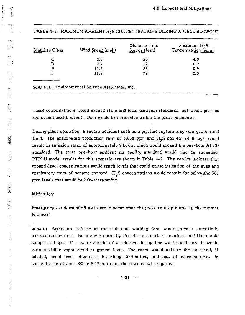
IIII
h
I
4.0 Impacts and Mitigations
TABLE 4-8: MAXIMUM AMBIENT H2S CONCENTRATIONS DURING A WELL BLOWOUT
Distance from Maximwn HGSStabili ty Class Wind Speed (mph) Source (feet) Concentration ppm)
C 3.5 50 4.3D 2.2 52 8.2E 11.2 88 0.9F 11.2 79 2.3
SOURCE: Environmental Science Associates, Inc.
These concentrations would exceed state and local emission standards, but would pose no
significant health affect. Odor would be noticeable within the plant boundaries.
During plant operation, a severe accident such as a pipeline rupture may vent geothermal
fluid. The anticipated production rate of 5,000 gpm and H2S content of 8 mgn could
resul t in emission ra tes of approxima tely 9 kg/hr, which would exceed the one-hour APCD
standard. The state one-hour ambient air quality standard would also be exceeded.
PTPLU model results for this scenario are shown in Table 4-9. The results indicate that
ground-level concentrations would reach levels that could cause irritation of the eyes and
respiratory tract of persons exposed. H2S concentrations would remain far below.the 500
ppm levels that would be life-threatening.
Mitiga tion:
Emergency shutdown of all wells would occur when the pressure drop cause by the rupture
is sensed.
Impact: Accidental release of the isobutane working fluid would present potentially
hazardous conditions. Isobutane is normally stored as a colorless, odorless, and flammable
compressed gas. If it were acciden tally released during low wind condi tions, it would
form a visible vapor cloud at ground level. The vapor would irritate the eyes and, if
inhaled, could cause dizziness, brea thing difficul ties, and loss of consciousness. In
concentrations from 1.8'70 to 8.40/, with air, the cloud could be ignited.
4-31
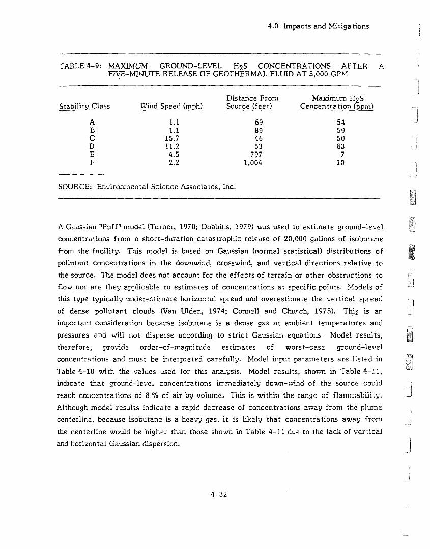
4.0 Impacts and Mi tiga tions
TABLE 4-9: MAXIMUM GROUND-LEVEL H2S CONCENTRATIONS AFTER AFIVE-MINUTE RELEASE OF GEOTHERMAL FLUID AT 5,000 GPM
Distance From Maximum H~SStabili ty Class Wind Speed (mph) Source (feet) Cencentrlltion ppm)
A 1.1 69 54B 1.1 89 59C 15.7 46 50 ID 11.2 53 83E 4.5 797 7F 2.2 1,004 10 ]
SOURCE: Environmental Science Associates, Inc.
A Gaussian "Puff" model (Turner, 1970; Dobbins, 1979) was used to estimate ground-level
concentrations from a short-duration catastrophic release of 20,000 gallons of isobutane
from the facility. This model is based on Gaussian (normal statistical) distributions of
pollutant concentrations in the downwind, crosswind, and vertical directions relative to
the source. The model does not account for the effects of terrain or other obstructions to
flow nor are they applicable to estimates of concentrations at specific points. Models of
this type typically underestimate horizc:otal spread and overestimate the vertical spread
of dense pollutant clouds (Van Ulden, 1974; Connell and Church, 1978). Thi~ is an
important consideration because isobutane is a dense gas at ambient temperatures and
pressures and will not disperse according to strict Gaussian equations. Model results,
therefore, provide order-of-magni tude estimates of worst-case ground-level
concentrations and must be interpreted carefully. Model input parameters are listed in
Table 4-10 with the values used for this analysis. Model results, shown in Table 4-11,
indicate that ground-level concentrations immediately down-wind of the source could
reach concentrations of 8 '7. CJf air by volume. This is within the range of flammability.
Although model results indicate a rapid decrease of concentrations away from the plume
centerline, because isobutane is a heavy gas, it is likely that concentrations away from
the centerline would be higher than those shown in Table 4-11 dV2 to the lack of vertical
and horizontal Gaussian dispersion.
4-32
J
JJI
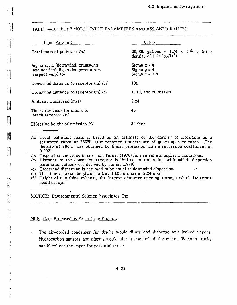
TABLE 4-10: PUFF MODEL INPUT PARAMETERS AND ASSIGNED VALUES
4.0 Impacts and Mitigations
TI
I!
Ii
III
Input Parameter
Total mass of pollutant lal
Sigma x,y,z (downwind, crosswindand vertical dispersion parametersrespectively) fbI
Down""ind distance to receptor (m) Icl
Crosswind distance to receptor (m) IdJ
Ambient windspeed (m/s)
Time in seconds for plume toreach receptor leI
Effective heigh t of emission If!
Value
20,000 gallons • 1.74 x 10⁶ g (at adensity of 1.44 Ibs/ft3).
Sigma x • 4Sigma y. 4Sigma z • 3.8
100
1, 10, and 20 meters
2.24
45
30 feet
Ij
I
lal Total pollutant mass is based on an estimate of the density of isobutane as asaturated vapor at 280°F (the reported temperature of gases upon release). (Thedensity at 280°F was obtained by linear regression with a regression coefficient of0.992).
fbI Dispersion coefficients are from Turner (970) for neutral atmospheric conditions.Icl Distance to the downwind receptor is limi ted to the value with which dispersion
parameter values were derived by Turner (1970).IdJ Crosswind dispersion is assumed to be equal to downwind dispersion. .'leI The time it takes the plume to travel 100 meters at 2.24 m/s.If! Height of a turbine exhaust, the largest diameter opening through which isobutane
could escape.
SOURCE: Environmental Science Associates, Inc.
Mitigations Proposed as Part of the Project:
The air-cooled condenser fan drafts would dilute and disperse any leaked vapors.
Hydrocarbon sensors and alarms would alert personnel of the event. Vacuum trucks
would collect the vapor for potential reuse.
4-33
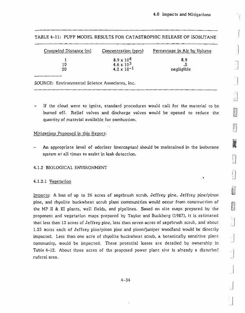
4.0 Impacts and Mitigations
TABLE 4-11: PUFF MODEL RESULTS FOR CATASTROPHIC RELEASE OF lSOBUTANE
SOURCE: Environmental Science Associates, Inc.
Crosswind Distance (m)
11020
Concentration (ppm)
8.9 x 1044.6 x 1034.2 x 10-1
Percentage in Air by Volume
8.9.5
negligible
1£ the cloud were to ignite, standard procedures would call for the material to be
burned off. Relief valves and discharge valves would be opened to reduce the
quantity of material available for combustion.
Mitigations Proposed in this Report:
An appropriate level of odorizer (mercaptan) should be maintained in the isobutane
system at all times to assist in leak detection.
4.1.2 BIOLOGICAL ENVIRONMENT
.<
4.1.2.1 Vegetation
Impacts: A loss of up to 26 acres of sagebrush scrub, Jeffrey pine, Jeffrey pine/pinon
pine, and rhyolite buckwheat scrub plant communities would occur from construction of
the MP 11 & III plants, well fields, and pipelines. Based on site maps prepared by the
proponent and vegetation maps prepared by Taylor and Buckberg (l987), it is estimated
that less than 13 acres of Jeffrey pine, less than seven acres of sagebrush scrub, and about
1.25 acres each of Jeffrey pine/pinon pine and pinon/juniper woodland ""ould be directly
impacted. Less than one acre of rhyolite buckwheat scrub, a botanically sensitive plant
community, would be impacted. These potential losses are detailed by ownership in
Table 4-12. About three acres of the proposed power plant site is already a disturbec
ruderal area.
4-34
I
j
.!
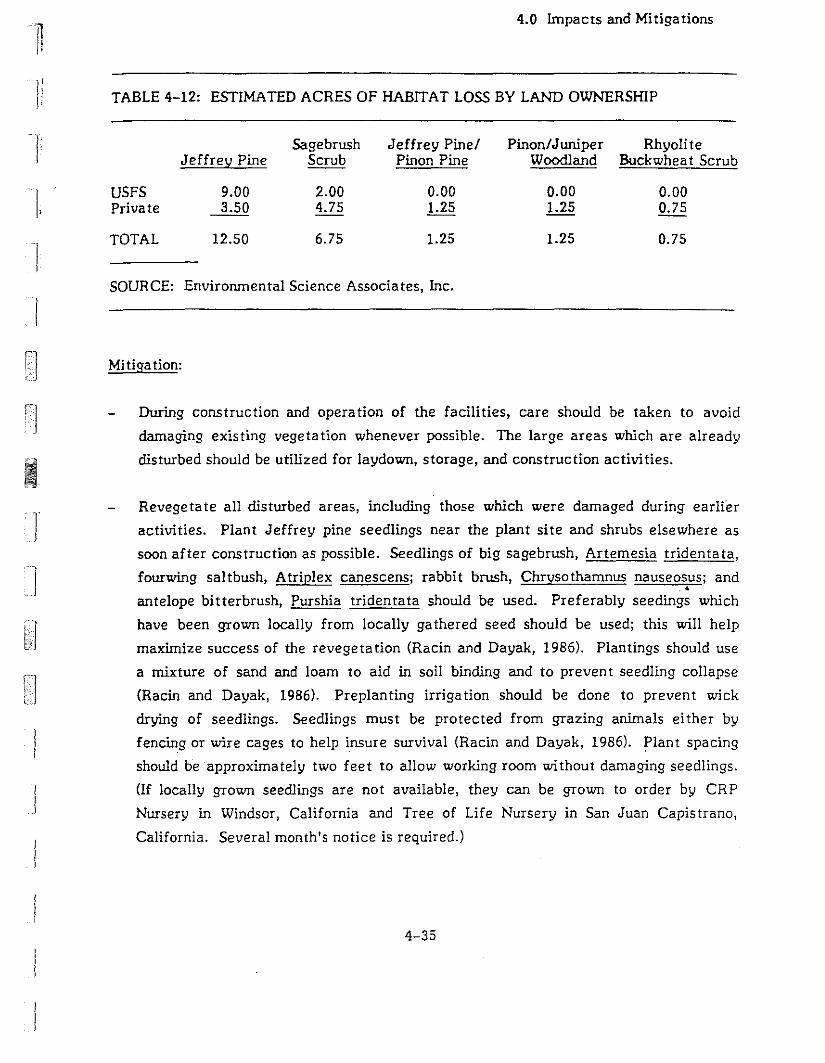
1I
4.0 Impacts and Mi tiga tions
TABLE 4-12: ESTIMATED ACRES OF HABITAT LOSS BY LAND OWNERSHIP
Sagebrush Jeffrey Pinel Pinon/Juniper RhyoliteJeffrey Pine Scrub Pinon Pine Woodland Buckwheat Scrub
USFS 9.00 2.00 0.00 0.00 0.00Private 3.50 4.75 1.25 1.25 0.75
TOTAL 12.50 6.75 1.25 1.25 0.75
SOURCE: Environmental Science Associates, Inc.
Mitiga tion:
During construction and operation of the facilities, care should be taken to avoid
damaging existing vegetation whenever possible. The large areas which are already
disturbed should be utilized for laydown, storage, and construction activities.
Revegetate all disturbed areas, including those which were damaged during earlier
activities. Plant Jeffrey pine seedlings near the plant site and shrubs elsewhere as
soon after construction as possible. Seedlings of big sagebrush, Artemesia tridenta ta,
fourwing saltbush, Atriplex canescens; rabbit brush, Chrysothamnus nauseosus; and.4
antelope bitterbrush, Purshia tridentata should be used. PreferablY seedings which
have been grown locally from locally ga thered seed should be used; this will help
maximize success of the revegetation (Racin and Dayak, 1986). Plantings should use
a mixture of sand and loam to aid in soil binding and to preven t seedling collapse
(Racin and Dayak, 1986). Preplanting irrigation should be done to prevent wick
drying of seedlings. Seedlings must be protected from grazing animals either by
fencing or wire cages to help insure survival (Racin and Dayak, 1986). Plant spacing
should be approximately two feet to allow working room without damaging seedlings.
(If locally grown seedlings are not available, they can be grown to order by CRP
Nursery in Windsor, California and Tree of Life Nursery in San Juan Capistrano,
California. Several month's notice is required.)
4-35
4.0 Impacts and Mitiga tions
Seedling survival should be monitored. If after three years, less than 50% of
seedlings have survived then replacement planting should be conducted. Survival of
shrub seedlings was studled at a site in eastern California similar to the project site.
The survival rate after one year for Artemesia tridenta and Atriplex canescens was
94%. For Chrysothamnus nauseosus the survival rate was 88%. Fifty-eight percent
of the Purshia tridentata survived one year. Mortality was caused by transplant
shock, lack of water from drying winds, extreme temperatures, and burrowing
animals (Racin and Dayak, 1986).
Use drip irrigation of trees and shrubs until they are sufficiently tall to screen
facilities (Novak, 1986). Without irrigation, seedlings of Jeffrey pine coulj be
expected to reach between five and eight feet in height after ten years with
diameter-breast-height (dbh) of 0.6 to 2.2 inches. After 20 years, the heights would
range from 13 to 26 feet with dbh 3.8 to 6.6 inches (Oliver and Powers, 1978). It is
likely that the trees would be at the large end of the size ranges if they were
irrigated.
Impact: Pipeline construction may impact botanically sensitive areas near the proposed
plant. Construction of the proposed pipeline connecting wells MPI 42-32, MPI 42A-32,
MPI 42B-32, MPI 42C-32, MPI 52-32, and MPI 52A-32 with the power plants may impact
botanically sensitive areas. The pipeline from wells MP 12-32 and MP 12A-32 may pass
through a. botanically sensitive area. The botanically sensitive areas are all on private
land (see Figure 3-5). . •
Mi tiga tion:
Pipelines and new access roads should be sited so that construction activities avoid
the sensitive areas. This may require adjustments of well locations. Refer to the
site plan in Figure 2-2 for the presently planned locations of wells. During the siting
phase, a botanist should ground-truth the locations of the wells and pipelines to
ensure that they will not impinge on the botanically sensitive areas. The following
changes are recommended:
o U.S. Forest Service Land: No changes are recommended for wells or pipelines
on USFS land.
4-36
I1
I
.... j
j
j
Ij
j
I:o
4.0 Impacts and Mi tiga tions
Private Land: Move injection well MPI 52-32 approximately 100 fept north of
its proposed location. Move the pipeline from wells MP 12-32 and MP 12A-32
approximately 50 feet north to avoid the botanically sensitive area to the west
of the proposed power plan t si tes.
1j
Prior to construction, botanically sensitive areas should be fenced to prevent
encroachment by construction vehicles and equipment. Simple single-strand wire
fence with colored surveyor's flagging should be sufficient to prevent entry by
vehicles. Vehicles should be restricted to existing roads.
4.1.2.2 Terrestrial Wildlife
Impact: A loss of up to 18 acres of sagebrush scrub and Jeffrey pine wildlife habitats is
expected from construction of the power plant. These are widespread habitats in the area
and there would be no significant impacts to populations of species using these habitats.
Populations of pygmy nuthatches and hairy woodpeckers are not expected to be impacted,
as less than eight acres of Jeffrey pine habitat would be lost. The pine stands, because
they are young and have few snags, are of moderate value for these species. The pine
stands provide feeding habitat, but no valuable nesting habitat. No impacts to sage grouse
populations are expected, as the area receives little sagegrouse use and there are no
nearby leks. No endangered,. threatened or other special status animal species are known
to use the site. Thus no impacts to these species are expected.. .
Mitiga tion:
None is necessary.
Impacts: Noise and human activity may reduce songbird density near the power plants and
may cause migratory deer to avoid the area. The impact on pygmy nutchatch and hairy
woodpecker poiJUlations is not expected to be significant (PG&E, 1986).
4-37
4.0 Impacts and Mi tiga tions
Mi tiga tion:
Minimize noise generated by construction and operation of the plant (see
Section 4.1.1.3). This may serve to reduce impacts on wildlife, but the correlation
between songbird density and noise levels has not been unequivocally demonstrated,
so a definite result cannot be predJcted. Similarly, it is unclear to what extent deer]
are affected and no specific result can be anticipated with respect to deer
populations and noise levels (PG&E, 1986). ·1
Impacts: Fifty to 100 migratory deer from the Buttermilk, Sherwin Grade, and Casa
Diablo Herds would be impacted by construction and operation of the power plant and
associated pipelines. The plant and pipelines may directly impede deer movements
through the area and pipeline configuration may funnel deer in to impassable areas. These
impacts would occur from development of either the proposed or alternate power plant
locations. Migration routes in the site area are not well defined. Deer have been found to
move across a broad area in this flat terrain in contrast to the narrow, constrained
corridors of the Sierran escarpment (Kucera, 1987b). IMigratory deer may be impacted by construction and operation of the power plant and
associa ted pipelines. The plant and pipelines may directly impede deer movements
through the area and pipeline configura tion may funnel deer into impassable areas .
. <Mi tiga tion:
Design pipelines and fencing to avoid a funneling effect. Either bur,· short segments
of pipelines as crossings or build crossing ramps to allow deer passage. Crossing
points should be no farther than one-eighth mile (660 feet) apart. Crossings or
crossing ramps should be at least 10 feet wide and at a gently sloping angle. These
measures should insure adequate crossing opportunities for migratory deer.
If necessary, consider the appropriation of funds toward the purchase of federal land
in the Swall Meadow area for winter range habitat.
j
4-38 JJ
nJl
]I
II
1
)
I
I!
4.0 Impacts and Mitigations
4.1.2.3 Aqua tic Resources
4.1.2.3.1 Construction Activities
Impact: Increased sedimentation In Mammoth/Hot Creek may result from grading of new
roads and building surfaces. Elevated turbidity levels would clog and irritate gill
structures and impair respiration, feeding, and swimming capabilities of resident fish and
aqua tic Invertebra tes.
Mi tiga tion:
See Section 4.1.1.1 for a discussion of the measures to control erosion and
sedimentation.
Impact: Organic compounds which would be used during drilling and construction could
spill and contaminate local waters. Paint, diesel fuel, lubricating oils, and small
quantities of solvents would be stored and used on-site. These compounds are toxic in low
concentrations and would cause adverse effects to aquatic resources if any leakages or
spills occur into project waters.
Mi tiga tion:
All paints, fuels, lubricants, solvents, or other compounds potentially harmful to
aquatic organisms should be stored In secure containers within the bermed areas so
that leaks would be contained. Permit requirements of the Lahontan RWQCB should
suffice to mitigate this potential impact.
4.1.2.3.2 Long-Term Activities
Operation of the plant would require pumping from the geothermal reservoir. As
discussed in Section 4.1.1.2.3, Water Quality and Hydrology, there is no consensus on how
subsurface thermal resources move within the Long Valley caldera so it is not possible to
make a definitive statement about how operation of the plant would affect the springs
which supply Hot Creek Hatchery. Section 4.1.1.2.3 discusses the impacts of the project
on water quality and hydrology. In that section two possible effects are identified. The
first would be thermal contamination of surface water due to the rupture of lines feeding
4-39
4.0 Impacts and Mitigations
geothermal fluid to a power plant. The second, which is not predicted based on modelling
of the system as it is now understood, is a decrease in either the volume or temperature
of the water in the reservoir beneath Hot Creek Hatchery or Hot Creek Gorge. The
following discussion is based on the assumption that adverse effects would occur. In fact,
it is the intent of the monitoring program to identify adverse impacts based on
observations made at the established monitoring points and to allow implemention of
appropriate mitigation measures before the Hot Creek Hatchery or Mammoth/Hot Creek
fishery is adversely affected.
Impact: If the production pipelines feeding a plant rupture, pressure would suddenly drop
and the wells would be shutdown automatically. Assuming the worst-case scenario that
the full production of 5,000 gpm of superheated geothermal fluid from one plant is
released for five minutes, there would be a flow of approximately 10 cfs of 200°F fluid
released for the five minute period. (This assumes that approximately 15% of the fluid
would flash to steam as the pressure drops to atmospheric.) If none of the released fluid
infiltrates, it would flow in the intermittent streambed into Mammoth Creek. Even if the
heat losses from evaporative cooling, heating of the stream bed, and mixing with flow, if
any, in the intermittent stream cause the temperature to drop significantly below 200°F,
there would be a slug of relatively high temperature water reaching Mammoth Creek.
Based on current knowledge of trout physiology, rainbow trout will survive temperatures
of 32°F to 82°F, with optimum temperature for growth and completion of most life
history stages at 55°F to 70°F (Moyle, 1976). Temperatures of 45°F to 66°F are optimum
for rapid growth of brown trout, with preference for temperatures at the upper ena' of this
range. Brown trout are able to withstand short exposures to temperatures in excess of
81°F. If the slug of geothermal fluid raises the stream temperature to neal or above the
upper temperature limits of these fishes, mortality would occur. The extent and severity
of the fish kill would depend on the time of year and the condition of the fish a t the time
of the spill.
Mi tiga tion:
Reduce the maximum flow of geothermal fluid which could reach Mammoth Creek, so
that the volume of hot geothermal fluid reaching Mammoth Creek would be
sufficiently small that it would not adversely affect the Mammoth/Hot Creek fishery.
4-40
)
j
J

1i
I
1
4.0 Impacts and Mitigations
Impact: The operations of the Hot Creek Hatchery are dependent on the constant
temperature and reliable flows of the several springs which supply the facility. Depending
on their location on the hatchery site, individual springs vary annually in temperature
from approximately 53°F to 63°F, with the mean temperature of all springs being
approximately 58°F. The set of upper springs, AB springs (60°F.±. 2°F) to the north and
CD springs (57°F ± 2°F) to the south, feed the production, or rearing, ponds and maintain
these temperatures throughout the year (Eichmann, 1987b). These ponds would not be as
sensitive to slight temperature variations as the broodstock facilities. A decrease of
greater than two degrees from the present temperature regime would slow fish growth
and result in higher costs to the hatchery program because of the additional feed needed
and the larger number of ponds and water which would be required to hold the fish for a
longer period of time until they reached suitable planting size (Eichmann, 1987c).
Smaller springs at the lower (east) end of the hatchery grounds, probably the most critical
to the hatchery program, supply the broodstock facilities. The springs feeding the
Hatchery 1 broodstock pond complex are a' a temperature of approximately 54°F ± 1°F
throughout the year. At the Hatchery 2-3 broodstock pond complex, yearly temperatures
average 52°F ± 1°F. Within these two complexes, up to seven strains of wild and domestic
cutthroat, rainbow, brook, and golden trout are spawned on a staggered schedule
throughout the year. The Coleman strain of rainbow trout is of particular importance
because it spawns after the Hot Creek strain (e.g., November through January versus July
through September) and before trout raised at other facilities, thus enabling the hatchery
to plant trout year-round. In order to produc,! good quality eggs, the rainbow trout must
be held for at least six months before spawning in waters not exceeding 56°F, but
preferably not above 54°F. A temperature Increase of one degree may resul t in a 5% to
15% decrease in fertility whereas a 2°F increase would kill virtually all the eggs and
severely impact the hatchery operation (Eichmann, 1987b). A reduction of 2°F in the
present temperature range would delay spawning until spring due to the increased time
period necessary for egg maturation. This would for all practical purposes eliminate the
Coleman and Hot Creek strains and severely impact the hatchery's statewide trout
planting program.
If production of geothermal fluid at the project does, contrary to the predicted results,
cause a decrease in the temperature or amount of thermal water reaching Hot Creek
Hatchery, its operations would be adversely affected.
4-41
4.0 Impacts and Mi tiga tions
Mitigation:
Supply the necessary thermal water by drilling wells to tap the geothermal reservoir
or heat the water to the proper temperature using another source of energy. Using
geothermal water would further deplete the geothermal reservoir and would require
an investment in equipment to achieve the appropriate mix of pumped and spring
water.' Heating water probably would be prohibitively expensive (see Economics, JSection 4.1.3.2) and is not a feasible mitigation for the loss of thermal water to Hot
Creek Hatchery. )
Impact: The endangered Owens Tui Chub is known to exist in pools near the headwaters Jof Hot Creek. Sediment leaving the project area could not affect these pools because L.
they are located above the Hot CreekIMarrunoth Creek confluence. Similarly, a spill of
geothermal fluid would not affect the Owens Tui Chub. The hydrology report has stated
that geothermal development at Casa Diablo will not affect shallow ground water near
Hot Creek and therefore should not affect these fish. If there are unknown refugia
occupied by the Owens Tui Chub within the area affected by runoff from the project, the
project could adversely affect fish using those refugia.
Mitigation:
A survey of waters within the project area is being undertaken to confirm the
presence/absence of the endangered Owens Tui Chub. If any of these fish are found.<
during the survey, they will be protected pursuant to stipulations rendered by a
biological opinion to be prepared by the U.S. Fish and Wildlife Service as specified by
Section 7 of the Endangered Species Act.
4.1.3 SOCIAL ENVIRONMENT
4.1.3.1 Visual Resources
Impacts: Drilling rigs and accessory equipment would be strong, but temporary, visual
elements of the landscape because of their form, size, strong vertical lines, and strong
contrasting colors. Once the wells were completed, the wells would be capped and the
drilling equipment would be removed, eliminating any substantial structures from the well
si tes.
4-42
)
IJ
)
IJ
II
]
II
4.0 Impacts and Mitigations
Mi tiga tion:
None is necessary.
Impacts: Well pads, wellhead equipment, pipelines, and access roads would become
long-term features of the landscape. Grading for well pads and access roads would alter
the natural form of the landscape slightly. The smooth, horizontal lines of the roads,
transmission lines, and pad St: faces would contrast with the existing slopes and ridges,
which are undulating and irregular, without sharp lines or divisions. These project
elements would differ also in texture from existing natural surface features. The road
and well pad surfaces could contrast in color with existing vegetation and surface soils.
Once the drilling rigs and associated equipment were removed from the well sites, the
well pads, wellhead equipment, fluid transmission lines, and access roads could be visible
to northbound traffic from Highway 395 from about one mile southeast of the Casa Diablo
area to about one-half mile south of the Casa Diablo area and from Sta te Route 203 east
of Highway 395. The degree of visibili ty from these viewpoints and the degree of contrast
probably would be moderate, however, depending upon the exact placement of well pads,
alignment of access roads, and extent of revegetation and screening. With appropriate
mitigation for visual effects, the overall visual impact would be slight to moderate.
The power plant would be the most visible element of the project, visible from State
Route 203 east of Highway 395; from northbound Highway 395 for a distance of abOut one
mile beginning at a point near the west end of the airport four miles from the plant site;
and again from northbound Highway 395 from about one mile sQutheast of Casa Diablo to
one-half mile south of Casa Diablo; from a short segment of State Route 203 about one
mile west of the plant site; and from portions of Sawmill Road about 1.5 miles west of the
plant site. The viewpoint from which the most viewers see the site is on Highway 395
near the meadow containing Mammoth Creek. The generator and condensers, at heights
of about 30 feet above grade, would stand out because of the lack of topographic or
vegetative screening in the foreground, as described in the Setting. At night, work lights
and structural lighting of the power plant would be clearly visible. The views of the
power plant and accessory structures would create the impression of industrial activity
4-43

4.0 Impacts and Mi tiga tions
which would contrast with the generally natural character of the surrounding landscape.
Figure 4-2 is a photomontage of the proposed plant in the existing setting as seen from
State Route 203 jll't east of Highway 395.
The project would be clearly visible to motorists on Highway 395 and is therefore in
conflict with the Visual Management Objective (VMO) of "Retention" which has been
established by the USFS for the project area.
Mi tiga tions:
Lay out well pads and roads so tha t rna ture trees are preserved.
Disturbed soil areas should be partially or completely revegetated as soon as
practical once construction and site development are completed.
Native trees and shrubs should be planted on the project site to screen equipment
yards and accessory structures, and the lower portions of the major structures on the
site. Screening by trees and shrubs would be increasingly effective as the vegetation
grew taller. This concentration of vegetation would appear somewhat un-natural to
most viewers, but would result in less impact than exposed views of the power plant
site. See Section 4.1.2.1, Vegetation, for of discussion of revegetation.
Exteriors of structures, including pipelines and their supports, should be a neutral
earth-tone color.
To the extent compatible with engineering considerations, all exterior surfaces should
be a rough texture, with no reflective metal or glass surfaces oriented toward the
south or wes t.
Insert redwood laths in all chain link fencing.
Exterior structural lighting should be minimized; where exterior lighting is necessary,
diffuse lighting systems should be kept under about five-foot candles. Work lights
should be switched or equipped with timers, rather than being designed for continuous
use, and workers should be encouraged to minimize the use of night lighting.
4-44
I
JJ
I
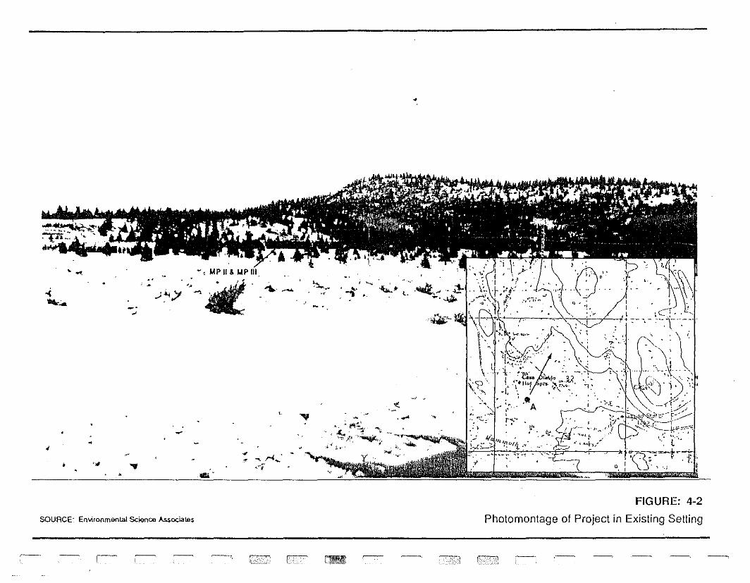
1
"'1J
:T 0
I0 :3 0 :oJ 0;- to CD S. "'1
J~
)0 -, CD D. 3
'm x
::!!f2' 3
'G
)
toc:
(f)
:0
CD~
3'~ ,
toI\
.l
i c
.' \
(
,1
,'t.
l. '1:
\(. ..
jI
~.'
~ .." = ... :r ."
".
.'.
.4
4.0 Impacts and Mitigations
Apply the above mitigation measure to the MP I plant.
Locate the plant 400 to 500 feet east of the proposed plant site to take advantage of
the screening which would be provided by the mature treees.
Other mitigations would serve to make the plant less conspicuous, especially placing the
plant in the al terna te loca tion.
Even with mitigations, the plant would be noticed by casual observers and the project
would therefore be inconsistent with the VMO of "Retention".
4.1.3.2 Socioeconomics
4.1.3.2.1 Land Use and Planning
Impact: The proposed construction of MP II & III project would intensify the industrial
activity at the site. The most noticeable impacts would be concentrated on site, in the
form of disrupting the open space and grazing land uses of the presently undisturbed parts
at the site. Soil would be disturbed as the plant site and well pads were being cleared and
prepared for construction. Areas northeast of the plant site would also be cleared and
graded for new access roads serving the injection wells. The use is compatible with
current County and USFS plans, with the exception of the visual management policies
discussed above. . •
Mi tiga tion:
See Section 4.1.1.1, Soils and Erosion, Section 4.1.2.1, Vegetation, Section 4.1.3.1,
Visual Resources, Section 4.1.3.5, Range, and Section 4.1.3.4, Timber.
4.1.3.2.2 Employment, Population and Housing
Impact: The type and amount of employment generated by the MP II & III power plants
U', uld differ between the construction and operation phases. Based on the work force
used during the construction of the existing MP I facility, the construction phase
employment for each plant is expected to fluctuate with the stage of power plant
construction and well drilling, averaging 48 workers over a nine-month period, and
4-46
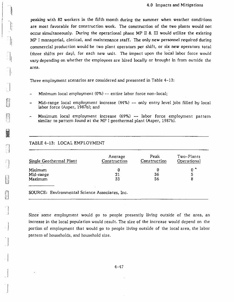
i1
I
J
J
4.0 Impacts and Mi tiga tions
peaking with 82 workers in the fifth month during the summer when weather conditions
are most favorable for construction work. The construction of the two plants would not
occur simultaneously. During the operational phase MP II & III would utilize the existing
MP I managerial, clerical, and maintenance staff. The only new personnel required during
commercial procluction would be two plant operators per shift, or six new operators total
(three shifts per day), for each new unit. The impact upon the local labor force would
vary depending on whether the employees are hired locally or brought in from outside the
area.
Three employment scenarios are considered and presented in Table 4-13:
Minimum local employment (0%) -- entire labor force non-local;
Mid-range local employment increase (44%) -- only entry level jobs filled by locallabor force (Asper, 1987b); and
Maximum local employment increase (69%) -- labor force employment patternsimilar to pattern found at the MP I geothermal plant (Asper, 1987b).
TABLE 4-13: LOCAL EMPLOYMENT
Average Peak Two-PlantsSingle Geothermal Plant Construction Construction Opera tional
Minimum 0 0 o· •Mid-range 21 36 5Maximum 33 56 8
SOURCE: Environmental Science Associates, Inc.
Since some employment would go to people presently living outside of the area, an
increase in the local popula tion would resul t. The size of the increase would depend on the
portion of employment that would go to people living outside of the local area, the labor
pattern of households, and household size.
4-47

4.0 Impacts and Mitigations
For this analysis, it has been assumed that each non-local employee will have an average
household size of 2.33 (California Department of Finance, 1987). 1bis number is likely to
be smaller for temporary construction workers. Using the three employment scenarios,
the expected population increase is shown in Table 4-14.
TABLE 4-14: POPULATION INCREASES
Single Geothermal Plant
Minimum Local Employmen tMid-range Local EmploymentMaximum Local Employment
AverageConstruction
1086342
PeakCons truction
191126
61
Opera tional
2816
9
)
)
)
SOURCE: Environmental Science Associates, lnc.
Since a portion of employment would go to people presently living outside of the area, a
demand for housing would result. Most construction employees may be expected to seek
temporary housing; the operating employees would seek permanent housing. Experience
during the construction of the MP I geothermal plant indicated no problem with housing
the construction workforce. ln large measure, this was due to the fact that the greatest
population increase would coincide with the off-peak season, lessening the impact. Using
the maximum population increase scenario, the demand for permanent residential housing
would be expected to increase by less than 0.3%. Given the aImost two-year-Iong
construction period for both plants, construction of some additional housing can be
expected.
Mi tiga tion:
The percentage of the local labor force employed may be increased through the use
of "first source" hiring.
Construction activity should be timed so that peak construction housing needs do not
coincide with the peak tourist housing demand.
4-48
I
J
I
11
Ii]i
J
j
4.0 Impacts and Mitiga tions
4.1.3.2.3 Economics
Impacts: The local economy would benefit temporarily from the increased retail demand
and demand for housing during the peak construction phase. Employment in the
construction sector would also benefit. The local economy would experience a longer
lasting but lower level benefit during the operational phase from retail purchases made by
the plant and by plant employees, and from the availability of local entry level jobs. The
direct payroll is expected to be similar to the payroll at the MP I 10 MW geothermal plant
which totaled $451,000 in 1986. The annual payroll for 12 plant operators may be
expected to average $300,000. Local trade with Inyo/Mono County merchants from MP I
totaled $159,000 in 1986 (Asper, 1987b). Due to the unified nature of the expanded
facility (e.g., shared control room and on-site substation) the increase in local trade would
be somewhat less than $300,000. The year-round operation of the plant would help
stabilize the highly seasonal nature of employment and retail sales.
Mitigation:
None is necessary.
L'llpact: The possibility of negative local economic impacts is largely associated with the
unlikely but possible deple tion of geothermal wa ter at Hot Creek Gorg p and the Hot
Creek Hatchery. Such a loss would reduce employment, retail sales, and rentals based on
servicing trou t fishing and hot spring bathing, increasing the severity of the unbalanced
winter/swnmer tourist economy (Hawley, 1987).
The unique nature of the Hot Creek Hatchery and its fall spawning strain of rainbow trout
make it impossible to estimate the true economic value of their loss. The immediate loss
in terms of the "dollar value" of the recreational days provided by fish and eggs from the
Hot Creek Hatchery was estimated in 1976 to approximate $9,500,000 annually (Fullerton,
1976). Adjusted for inflation using the consumer price index for California produced by
the U.S. Department of Labor, Bureau of Labor Statistics, the "dollar value" today would
equal over $19,000,000 annually.
4-49
4.0 Impacts and Mitigations
Mi tiga tion:
None is necessary.
Impacts: Many of the costs incurred by the county in relation to the geothermal plant
would Le paid for by fees (e.g., processing permits, recording documents). Various
departments would incur costs not covered by applicant fees (e.g., Board of Supervisors,
Sheriff, County Counsell. The greatest demand for increased general county services and
fiscal expenditures would be associated with the increase in residential population. Mono
County's e'....perience with geothermal projects has not yet developed to the point where it
can be determined precisely what costs are associated with such a development. County
costs would also depend on the types of mitigation measures implemented.
Mi tiga tion:
Application fees should be adjusted to ensure that the fees charged actually cover
costs. Services which could be provided on a fee basis may be changed to such a basis.
The County could assess impact fees, user fees, and conduct maintenance agreements
to a">ure the costs need not be financed out of the general fund.
!
i
I
I
The greatest mitigation of community service costs would be the increasing .of local.]
hiring.
4.1.3.2.4 Community Services
Schools
Impacts: The impact on school facilities is tied directly to increased school enrollment. ·1School enro1Iment in turn will be dependent upon the demographic characteristics Of the
families of the non-local labor force. To estimate enrollment impacts, the Mammoth
School District uses a student generation factor of one student per 7.67 persons of
permanent population (Martin, 1987). With an average household size of 2.33 persons and
4-52
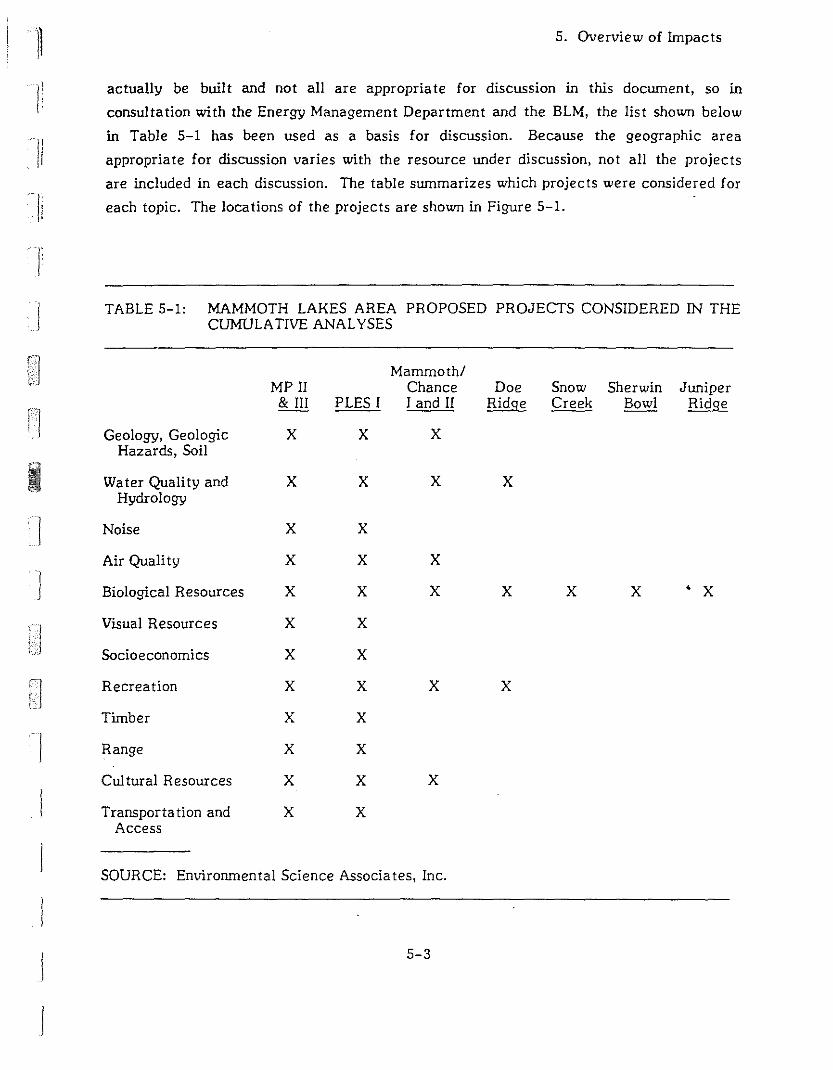
j
5. Overview of Impacts
actually be built and not all are appropriate for discussion in this doclUllent, so in
consultation with the Energy Management Department and the BLM, the list shown below
in Table 5-1 has been used as a basis for discussion. Because the geographic area
appropriate for discussion varies with the resource under discussion, not all the projects
are included in each discussion. The table slUllmarizes which projects were considered for
each topic. The locations of the projects are shown in Figure 5-1.
TABLE 5-1: MAMMOTH LAKES AREA PROPOSED PROJECTS CONSIDERED IN THECUMULATIVE ANALYSES
Mammoth/MPII Chance Doe Snow Sherwin Juniper
&111 PLES I I and II Ridge Creek Bowl Ridge
Geology, Geologic X X XHazards, Soil
Water Quality and X X X XHydrology
] Noise X X
Air Quality X X X
J Biological Resources X X X X X X • X
Visual Resources X X
Socioeconomics X X
Recreation X X X X
Timber X X
Range X X
CuI tural Resources X X X
Transporta tion and X XAccess
SOURCE: Environmental Science Associates, Inc.
5-3
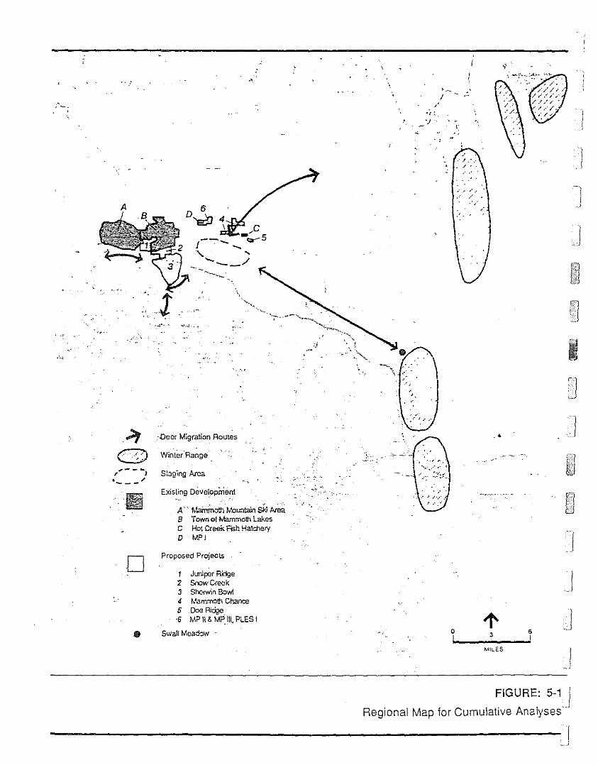
-,)
I
-,
/
,..,
\
,c--....... -c:r- 5
f . .....\,. "-
...... "'--_/
"~
I
" ..
A
::t -..l)eer Migration Routes
C.·~J Winlar"Range'
o
EXisting Deve'~oprnent
A'" tI.ainmOth lVountdin Ski IwaB Townol Wemmoth LakesC Hot Creek FISh HatcheryD MPI
Proposed ProjecLs
1 Juniper Ridge2 Soowc<eck3 Sh<:><win Bowl4 W"mmolh Chance5 DoeRidge·6 M?II& MPIII,PLESI
SwallMoa&lw
..
Jl' J-, 0 3 6
I !MII,.ES
./
FIGURE: 5-1 IRegional Map lor Cumulative Analyses'"
----------------J

nIi
,
j
4.0 L-npacts and Mitigations
Mitiga tions Included as Part of the Proposed Project:
Standard first aid supplies would be available throughout all phases of field
development, site construction and power plant operations.
Personnel would be instructed where both the first aid supplies and emergency
control services and emergency action notification lists are located.
All proposed on-site and off-site drilling, construction, and production activities
would be conducted in compliance with applicable safety regulations as administered
by the California Department of Industrial Relations, Division of Occupational Safety
and Health (Cal/OSHA). Wells would be drilled and completed in conformance with
the requirements of the U.S. Bureau of Land Management.
Surface pipelines would be covered wi th an insula tion wrapping which will preven t
burns from accidental contact with the geothermal pipelines.
Mitigation Recommended in this Report:
The Count,' emergency response plan should be revised to incorporate geothermal
development emergency needs.
•On-site personnel should be trained in first-aid and CPR.
Communica tion and evacuation procedures in the event of severe burn acciden ts
should be developed and maintained.
Fire Protection
Impacts: The construction and operational phases present different concerns for the Long
Valley Fire Protection District. The major concern during the construction phase is the
potential for forest or brush fires, especially during the end of the dry summer season.
During the operational phase, isobutane is used as the binary working fluid. It is a very
flammable substance used and stored on-site, so the possibility of an accident or an
equipment failure and the release of the isobutane to the atmosphere is a major concern.
4-55
4.0 Impacts and Mitigations
In such an event the isobutane could form a cloud at ground level which might be ignited.
The spreading of a fire during the seven to IS-minute response/access time is a serious
problem.
Were the fire to spread beyond the immediate area, safety concerns would focus on three
areas: 1) traffic on the adjacent Highway 395; 2) the three 10,000 gallon gasoline storage
tank owned by Chevron, located one-quarter mile southeast of State Route 203 and
one-eighth mile north of Highway 395; and 3) the 100,000 to 150,000 gallons of propane
stored in six tanks owned by Cal-Gas, Petro-Lane and Turner, located about one mile
from the site (Malby, 1987).
Mitigations Proposed as Part of the Project:
During the construction phase all safety regulations would be followed and portable
fire-fighting equipment capable of extinguishing small grass or paper fires would be
maintained on site.
The power plant would be designed in accordance with applicable Codes (e.g., 1976
and 1982 Uniform Fire Codes) and sound engineering practice, thus ensuring tha t
during normal operation there would be no evolution of working fluid to the
atmosphere other than from minor fugitive sources.
"
The air cooler draft fan would be situated in such a way that it can be expected to
dilute any working fluid leakage and harmlessly discharge it to the air. As an
additional safety measure, a berm would be erected on all four sides of the plant site
to prevent any leakage from migrating beyond the plant boundary.
In the event a working fluid leak is ignited, the equipment containing the working
fluid would be protected from overheating and fire damage by a fire resistant
insulation or cement. Such equipment includes the working fluid accumulato. vessel,
the working fluid to brine exchangers and the working fluid circulating pump suction
lines. The working fluid air coolers would be located on top of a steel supporting
structure some 20 feet above ground. The structural steel columns and beams would
be fireproofed against fire damage for two hours. This is the standard petroleum
refining practice where flammable liquids are handled.
4-56
J

:1
li
II
I:
j
]
4.0 Impacts and Mitigations
It is also standard practice to let a liquefied petroleum gas fire burn rather than to
attempt to extinguish the fire. Isolation valves and drain piping are sometimes used
to drain tanks, exchangers, etc., so tha t the burning time may be reduced. Where
practical, this practice would be followed. Relief valves which discharge through
pipes to a safe elevation would protect equipment from exceeding design pressures.
Fire control equipment would include: 1) Water storage tank (estimated
500,000 gallons); 2) fire pump and accessories, including: electric fire pump wi th
batteries and charger, diesel fire pump with diesel fuel system, jockey pump
controllers; 3) fire protection apparatus including: fire hydrants, monitors, and
valves; fire hoses; automa tic sprinkler for the control building; fire line pipes and
fittings; and 4) fire alarm system, including control panel, gas (jsobutane or
isopentane) detectors ultraviolet flame detectors, and ionization detectors.
Portable fire extinguishers would be installed throughout the plant arca and in
buildings for use on small grass or paper or refuse fires or smoldering si tua tions as
may arise. Standard first aid equipment would be on hand for any burn victims.
Mitigations Recommended by the Long Valley Fire Protection District:
Prior to the issuance of a use permit, a detailed fire prevention and protection plan
should be submitted and subjected to review and consideration by the Long Valley•Fire Protection District and the Mammoth Lakes Fire Department. in addition to the
fire protection system, this plan should address: automatic plant shutdOlm;
communication protocol with fire officials; emergency access/egress procedures for
the facilities, including roadway access maps for fire crews; discouragement of
smoking except in designated, specially prepared areas; maintenance of a checklist of
manpower and fire-fighting equipment, including off-site water sources, that are
available in the event of a fire; maintenance of all access routes and work si tes free
of vegetation and flammable material; and compliance with the 1982 Uniform Fire
Code.
In addition to the on-site fire protection equipment, a program of mitigation fees or
equipment donations is in place for new construction. The fees are charged on a
4-57
4.0 Impacts and Mitigations
square footage basis ($.30 a square foot). The program is being revised to incorporate
a separate fee system for geothermal plants based either on their megawatt capacity
or on the amount of flammable working fluid on site. TIle mitigation fee is expected ·1to range from $30,000 to $40,000 per 10 MW plant (Malby, 1987). Partial funding for
an additional Long Valley Fire District fire sta tion closer to the project may be
available through a state geothermal grant due to the specific nature of the
geothermal plant's working fluid. Such a grant would take the form of a matching
grant dependent upon mitigation fees raised from the developer (Malby, 1987).
Street and Road Maintenance
Impact: Heavy loads would be transported over county and USFS roads during each
nine-month construction period. This may result in the need for additional repair and
increased maintenance. The volume of traffic generated by the operational work force is
not expected to significantly increase the local traffic level of the roadway.
Mi tiga tion:
To recover the costs of repair, the county may consider entering into agreements
with the developers for the repair of any damage caused by project activities to the
road system. The cost of maintaining public (county or USFS) road used to access the
site can be transferred to the applicant by the use of such funding mechall.isms as
formalized maintenance agreements for maintenance and the repair of any damage to
the road system caused by geothermal traffic, conditional road use permits, and the
posting of performance bonds. Alternatively, a user fee based on weight and
frequency of use could be imposed.
Impacts: Because air-cooled condensers would be employed instead of water-cooled
towers, the potential problems of road icing and induced fog clouds from cooling tower
fluids would not present a problem. A slight potential for road icing and induced fog
clouds would exist during flow testing.
Mi tiga tion:
Conduct flow tests under atmospheric conditions that would minimize induced icing
and fog clouds.
4-58
I
j

11
J
4.0 Impacts and Mitigations
Wastewater
Impacts: Wa ter and sanl tary facili ties would be required during construction opera tions.
The expected water requirement for the facilities, based on an estimated manpower
requirement of 12 people, would be 225 gallons per day. nus would also entail the
generation of sanitary wastes. There would be no consumptive water use for power plant
cooling as air cooling would be used.
Mitigations Proposed as Part of the Project:
Bottled water would be furnished for drinking during construction and production
opera tions.
During the construction phase, portable chemical toilets would be utilized.
A water and permanent septic tank and leach line sewage disposal system would be
constructed at the site to for the use of the permanent work force. As there are no
shallow water wells in the vicinity of the proposed power plant site and the project
site is outside of the water service area of the Town of Mammoth Lakes, a water
storage tank would be constructed to store water delivered to the site from either
the existing MP I groundwater well or from a reverse osmosis treatment unit which
could be constructed on-site to treat cooled geothermal fluid. The water $torage
tank would also serve as an emergency water source for safety showers and
fire-fighting purposes. The water tank volume is estimated at 50,000 to
500,000 gallon capacity. Final tank volume would be determined during the
engineering design of the facilities. All waste disposal programs would be subject to
agency approval prior to the implementation and would be operated in accordance
with applicable federal, state, and local requirements.
Solid Waste
Impacts: Solid wastes would be generated through the drilling of the geothermal wells
and during the construction operations. Both are expected to be non-toxic. Because
solid waste disposal would be provided by private companies, these services would not
impact the county provision of services. Construction wastes composed of inert solids
(Group 3 wastes) and organic solids (Group 2 wastes) may be collected and transported to
4-59
4.0 Impacts and Mitiga· ions
the Class II landfill at Benton Crossing with no adverse effects. The increase in
residential wastes associated with the increase in residential population is not expected to
significantly affect the lifespan of the Benton Crossing landfill.
Mi tiga tion:
None is necessary.
Utili ties
Utilities would be contracted for on a private basis with short extensions from the MP I
plant. During normal power plant operations, parasitic electric power requirements would
be satisfied by electric power generated on-site. During start-up operations, electric
power would be purchased from SCE. This would not require any community service.
NOTE - Economics
III Hot Creek Hatchery uses a water flow of approximately 8,980 gallons per minute(Fullerton, 1976). The heat required in British thermal units (BTUs) to raise thetemperature of one gallon of water by 1°F is 8.3 BTUs. Assuming the springs feedingHot Creek Hatchery lost the thermal component and and the average temperaturedropped 2°C (3.6°F), the heat required to raise the temperature would beapproximately 0.4 billion BTUs a day. (8.3 BTU per gallon-degree x 3.6°F x 8,980gpm x 60 minutes per hour x 24 hours per day = 0.39 x 10⁹ BTU per day.) The annualcost of providing 0.4 billion BTUs a day, assuming; 1) the energy is provided throughthe use of heating oil, 2) a barrel of oil can deliver 5.6 x 10⁶ BTUs, and 3) a barrel ofoil costs $18.25, is approximately $500,000. (0.39x10⁹ BTUs per day I 5.6x10⁶ BTUsper barrel) x $18.25 per barrel x 365 days per year = $0.46x10⁶ per year.) This annualfuel cost could be higher or lower depending on the actual change in wa tertemperature, the type of fuel used, the efficiency of the energy conversion, and thecost of fuel. This estimate does not include the construction, maintenance, and otheroperating costs associated with such a project.
4.1.3.3 Recreational Resources
Operation of the plant would require pumping from the geothermal reservoir. There is no
consensus on how subsurface thermal resources move v.'ithin the Long Valley caldera so it
is not possible to make a definitive statement about how operation of the plant would
affect the springs which supply Hot Creek. Section 4.1.1.2 discusses the impacts of the
project on water quality and hydrology. In that section two possible effects are
4-60
I
)
!j
JJ
i
t"
11
I
I
4.0 Impacts and Mi tiga tions
identified. The first would be thermal contamination of surface water due to the rupture
of lines feeding geothermal fluid to a power plant. The second, which is not predicted
based on modelling of the system as it is now understood, is a decrease in either the
volume or temperature of the water in the reservoir beneath Hot Creek Hatchery and Hot
Creek Gorge. The following discussion is based on the assumption that adverse effects
would occur. in fact, it is the intent of the monitoring program to identify adverse
impacts based on observations made at the established monitoring points and to allow
implementation of appropriate mitigation measures before Hot Creek is adversely
affected.
Impact: If thermal springs at Hot Creek Gorge were depleted as a result of operating the
MP II & III plants, it would represent the loss of a unique recreational resource for which
no mitigation can be recommended.
Impact: The trout stocking program in California would be adversely affected if the
temperature of water used at Hot Creek Hatchery were lowered by more than 2°F.
Mi tiga tion:
See Aquatic Resources, Section 4.1.2.3, and Economics, Section 4.1.3.2, for a
discussion of ha tchery opera tions.
•Impact: If a spill of geothermal fluid resulted in significan t mortality, fishing in Hot
Creek would be temporarily adversely affected.
Mi tiga tion:
The effect would be temporary, so no mitigation is recommended beyond those
described in Section 4.1.1.2.3, Hydrothermal Resources, to confine the spill. See also
Section 4.1.2.3, Aquatic Resources.
Impact: There are no recreational facilities within the confines of the project area and
other than jogging, no known recreational activities occur within the project area.
Howe\ler Forest Road 3S05 and Scenic Highway 395 and State Route 203 are near the
4-61
4.0 Impacts and Mitigations
proposed site and serve as the main access roads for dispersed recreational activities in
the Little Antelope Valley. Recreationists driving, cycling, or jogging past the project
area may be adversely affected by the noise and industrial appearance of the facility.
Mi tiga tion:
See Section 4.1. 1.3, Noise, and Section 4.1.3.1, Visual, for suggested mitiga tions.
Impact: The power plant would attract the attention of people in the vicinity because it
is so different from the surrounding scenery. Visitors to the area would be likely to drive
by the plant to see it close-up and to satisfy their curiosity.
Mi tiga tion:
The project sponsor should be encouraged to participate in the installation of an
informational display which passers-by could visit. It could be as modest as a kiosk
or as ambitious as a formal visitors center, but it should describe the nature of the
geothermal resource and how it is being utilized in a way that casual visitors could
understand. Ideally this would be done in cooperation with the owners and operators
of the other power plants in the area and coordinated with the U.S. Forest Service
and Mono County Office of Geothermal Development.
.<
4.1.3.4 Timber Resources
Impacts: Merchantable-size Jeffrey pine would be harvested during the clearing of 15
acres for the project. About nine acres would be on USFS land and six acres on private
property. Where merchantable Jeffrey pines are present, timber volumes are estimated
at 24,000 board-feet/acre. At this stocking rate, about 216,000 board-feet would be
harvested from USFS land and ·144,000 broad-feet from private property. An unknown
percentage of this volume from USFS land is already under contract as part of the Bandit
Timber Sale. The Bandit Timber Sale volume is scheduled for harvest during the winter of
1987-88 and 1988-89. An unknown number of unmerchantable trees would be removed
during the clearing opera tions (McLean, 1987).
4-62
I
f
I1
J
n
TJ'
rI]
]
4.0 Impacts and Mi tiga tions
Mi tiga tions:
The operator should be required to purchase, at the prevailing market rate when the
site is cleared, all merchantable timber harvested.
Where feasible, well pads and pipelines should be sited in natural openings and
clearings.
Artificial clearings resulted from project developmen t should be oriented to avoid
clustering of small non-merchantable trees.
Reclaimed portions of well pads and pipeline pads should be replanted wi th na tural
vegetation. Reclaimed portions should be fenced to promote the revegetation effort.
The power plants facilities should be landscaped with natural vegetation.
4.1.3.5 Range Resources
Impacts: Construction of the proposed MP II & MP III project would remove
approximately 22.5 acres of range land from active use. This area equals about four
animal months (AMs). Half the area is USFS land within a range allotment and half is
privately owned. The private land is not fenced and, although not part of the allotment, is.<
grazed at the same level of intensity.
Mitiga tion:
Revegetate all non-occupied cleared USFS range lands so that portions of the range
could be eventually recovered. Revegetated areas should be fenced until the
replaced material is well established.
4.1.3.6 Cultural Resources
Potential adverse impacts to cultural resources sites in the general vicinity of the MP 11 &
III project may be of two kinds: direct and indirect. Direct adverse impacts would be
expected if construction of the proposed facilities altered the location of or destroyed
4-63

4.0 Impacts and Mitigations
cultural resources or areas traditionally used by Native American groups. Indirect
adverse impacts are less clear-cut and can be expected to occur beyond the actual spatial
confines of direct impact both during cons truction and opera tion.
Direct Impact: In the immediate VlCini ty of proposed MP II & III project, cul tural
resource sites PLES-8 and PLES-9 may be subject to direct adverse impacts from the
development of wells associated with the proposed plants. Unfortunately, because of the
original mapping scale (Hall, 1986), it is unclear whether either site would be directly
impacted by proposed construction activities. PLES-8, located on BL!'-l Land
Lease # 11667A, was recorded as consisting of both a prehistoric and an historic
component covering an area of approximately 78S square meters. The prehistoric
component consists of a moderate scattering of obsidian debitage waste flakes; the
historic remains include a tent or cabin foundation, milled lumber, saw-cut logs and
cut-wire nails. This site, as mapped by the field archaeologists on a IS-minute USGS
topographic map, is north of proposed wells pad MP152A-32 and MPl 42B-32. PLES-9,
located on private property owned by Magma Energy, Inc., consists of an moderate
scattering of obsidian debitage waste flakes covering an area of approximately 1,240
square meters. The western boundary of the site, as mapped on the USGS IS-minute
topographic map, is located north and east of proposed well sites MPl 52A-32 and MPl
S2-32.
Mitiga tion:.4
It would be necessary to determine first if proposed construction activities do, in
fact, fall within the site boundaries of PLES-8 and/or PLES-9. It is therefore
recommended that, before construction were to begin, an archaeologist visit the
exact areas of planned development to assess whether or not either of these sites
would be impacted. If nei ther P LES-8 nor PLES-9 is wi thin the confines of proposed
development, no further mitigation of direct impacts would be necessary.
If proposed development would impact a portion of PLES-8 and/or PLES-9, it may be
possible to locate the wells outside of the actual boundaries of the sites. Jf this is not
feasible, the wells should be located in areas characterized by relatively low
archaeological sensitivity. In such areas it is recommended tha t a two phase program
of evaluation be adopted. This program would involve the initial mapping and
4-64
I]
I
II
j
I
4.0 Impacts and Mitigations
systematic collection of surface cultural remains and lImited subsurface test
excavation to determine the extent of buried cultural deposits.
If the results of the first phase of evaluation indicate that these areas of PLES-B
and/or PLES-9 are significant and no practical mitigation alternative exists,
expansive data recovery investigations would be recommended.
Direct Impact: It is possible that subsurface cultural resources may be encountered,
damaged, and destroyed during construction.
Mi tiga tion:
It is recommended that, to the extent possible, an effort be made to monitor
development activities that may uncover buried cultural deposits. In the event that
cultural remains are discovered during subsurface construction, land alteration in the
general vicinity of the find should be halted and the Inyo National Forest
Archaeologis t should be consulted. Prompt evaluations by the California Sta te Office
of Historic Preservation and the National Forest Service would then be made
regarding the finds, and the course of action acceptable to all parties could then be
adopted.
Indirect Impact: Indirect adverse impacts may affect any cultural resources. in the
general vicinity of proposed geothermal development. Examples of indirect adverse
impact to cultural resources are increased recreational land-use of localities near project
facili ties where archaeological remains are visible by the public or by construction and
operating personnel.
Mi tiga tion:
Place locked gates on access roads which lead to culturally sensitive areas.
Use a focused program of educa ting project personnel to develop an awareness of the
surrounding cultural environment and the need to leave any cultural remains as they
are found in the environmen t.
4-65
4.0 Impacts and Mi tiga tions
Indirect Impact: The Bishop Elders have voiced concerns about proposed geothennal
development in areas where they have traditional Native American interests (Reynolds,
1987). Such interests include use of hot springs in the area for ritualistic purposes and the
collection of special plants which grow near hot springs.
Mi tiga tion:
A. representative of Mammoth Pacific met at the site with the Bishop Elders. The
project sponsor has agreed that Native Americans would have continued access to
resources important to their culture.
4.1.3.7 Transportation and A.ccess
Impact: During the construction phases, which would occur during two nine-month
periods, traffic would increase and would include heavy equipment. This could damage
State Route 203 and Hot Springs Road and inconvenience users of the roads. The volume
of traffic generated by the operational work force is not expected to significantly
increase traffic.
Mi tiga tion:
I]
I
As discussed in Section 4.1.3.2.3, under Street and Road Maintenance, the coupty may ]
consider methods of transferring road repair and maintenance costs to the applicant.
Impact: Traffic is some times heavy on the on- and off-ramps connecting Highway 395
and State Route 203. The heavy equipment going to and from the site could aggravate
conges tion.
Mi tiga tion:
Redirect project traffic to Hot Springs Road near the County buildings so that it Javoids the Highway 395/State Route 203 interchange.
4-66
)
I
4.0 Impacts and Mitigations
4.2 ALTERNATIVE LOCATION
4.2.1 PHYSICAL ENVIRONMENT
4.2.1.1 Geology, Geologic Hazards, and Soils
4.2.1.1.1 Geology and Geologic Hazards
Impacts and mi tiga tions associa ted wi th the alterna tive loca tion are the same as for the
proposed project.
4.2.1.1.2 Soils and Erosion
Construction of the power plants, access roads, well sites, pipelines and transmission lines
would result in soil disturbance. The expected amount of total disturbance is
approximately five acres for the power plant and 20 acres for well sites. About 1,800 feet
of access roads in addition to the existing dirt roads would be bull t; this would resul t in
disturbance of approximately one acre. Access roads would be sited to avoid cultural and
biological resources. Installation of pipelines would disturb an additional one-half acre.
Total site development would result in the temporary disturbance of no more than
27 acres. Most of the new access roads would be buil t on USFS land and used to reach the
injection wells for MP III; the other areas could be reached on existing dirt roads which"
lead to the SeE substation and existing wells for MP 1. After completion of construction
and revegetation, about five acres of dirt access roads and cleared areas around wells
would remain unvegetated for the life of the project. Table 4-16 summarizes the
disturbed area by land ownership.
All mitiga tion measures are the same as for the proposed project.
Grading would be necessary on the plant site to create level areas. Based on estimates
from the topographic map in Figure 2-2, the relief across the plant site is probably no
more than 15 feet. If the five acre power plant site were graded to one elevation, then
approximately 15,000 cubic yards of dirt would be removed from the higher areas and used
to fill the lower areas.
4-67
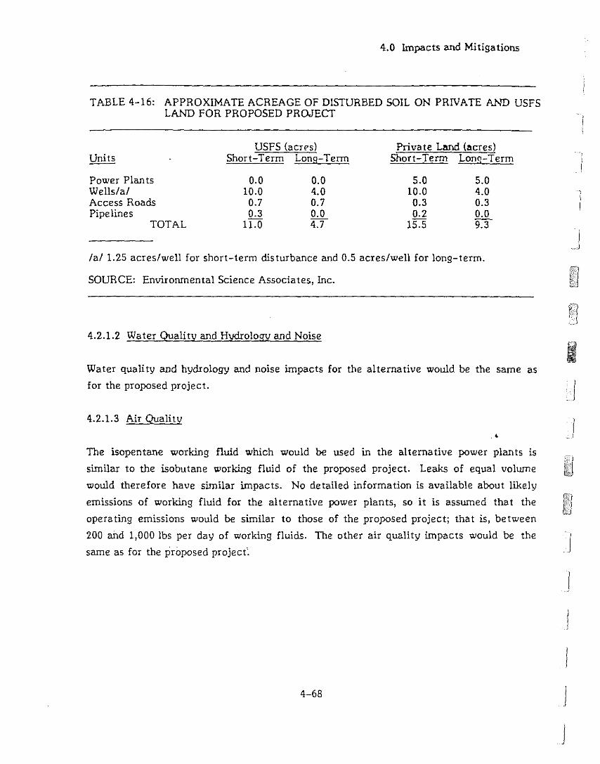
4.0 Impacts and Mitigations
TABLE 4-16: APPROXIMATE ACREAGE OF DISTURBED SOIL ON PRIVATE AND USFSLAND FOR PROPOSED PROJECf
iI
USFS (acrps)Short-Term Long-Term
Private Land (acres)Short-Term Lonq-Term
Power Plan tsWells/a/Access RoadsPipelines
TOTAL
0.010.00.70.3
11.0
0.04..00.70.04..7
5.010.00.30.2
15.5
5.04..00.30.09.3
I
/a/1.25 acres/well for short-term disturbance and 0.5 acres/well for long-term.
SOURCE: Envirornnental Science Associates, Inc.
4..2.1.2 Water Quality and Hydrology and Noise
Water quality and hydrology and noise impacts for the alternative would be the same as
for the proposed project.
4.2.1.3 Air Quality
.4
The isopentane working fluid which would be used in the alternative power plants is
similar to the isobutane working fluid of the proposed project. Leaks of equal volume
would therefore have similar impacts. No detailed information is available about likely
emissions of working fluid for the alternative power plants, so it is assumed that the
operating emissions would be similar to those of the proposed project; that is, between
200 and 1,000 lbs per day of working fluids. The other air quality impacts would be the
same as for the proposed projec(~
4-68
I
J
]
j
JJ
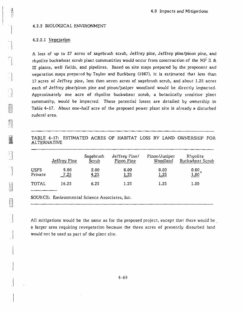
1I
II
1
4.0 Impacts and Mitigations
4.2.2 BIOLOGICAL ENVIRONMENT
4.2.2.1 Vegetation
A loss of up to 27 acres of sagebrush scrub, Jeffrey pine, Jeffrey pine/pinon pine, and
rhyolite buckwheat scrub plant communities would occur from construction of the MP II &
III plants, well fields, and pipelines. Based on site maps prepared by the proponent and
vegetation maps prepared by Taylor and Buckberg (1987), it is estimated that less than
17 acres of Jeffrey pine, less than seven acres of sagebrush scrub, and about 1.25 acres
each of Jeffrey pine/pinon pine and pinon/juniper woodland would be directly impacted.
Approximately one acre of rhyolite buckwheat scrub, a botanically sensitive plant
community, would be impacted. These potential losses are detailed by ownership in
Table 4-17. About one-half acre of the proposed power plant site is already a disturbed
ruderal area.
TABLE 4-17: ESTIMATED ACRES OF HABITAT LOSS BY LAND OWNERSHIP FORALTERNATIVE
Sagebrush Jeffrey Pinel Pinon/Juniper R!1yoliteJeffrey Pine Scrub Pinon Pine Woodland Buckwhea t Scrub
I USFS 9.00 2.00 0.00 0.00 0.00.Private 7.25 4.25 1.25 1.25 1.00
TOTAL 16.25 6.25 1.25 1.25 1.00
SOURCE: Environmental Science Associates, Inc.
Ii
All mitigations would be the same as for the proposed project, except that there would be .
a larger area requiring revegetation because the three acres of presently disturbed land
would not be used as part of the plant site.
4-69

4.0 Impacts and Mitigations
4.2.2.2. Terrestrial Wildlife and Aguatic Resources
The impacts and mitigations for the alternative would be the same as for the proposed
project.
4.2.3 SOCIAL ENVIRONMENT
4.2.3.1 Visual Resources
]
Existing mature trees located south and southeast of the alternative location would ~j
provide some screening for the power plants, so there would be less reliance on
revegetation to provide screening. 10 addition, the plants would be arranged so that MP 11
would partially obscure MP Ill.
All mitigation measures listed for the proposed project would apply to the alternative,
except for the use of the alternative location.
4.2.3.2 Socio-economicsI
The impacts of the alternative would be the same as for the proposed project.
4.2.3.3 Recreational Resources .4 JIf the plants are less visible in the alternative location than the proposed location, there
would be less impact on passers-by.
4.2.3.4 Timber Resources
Up to 18.75 acres of forest and woodland would be lost. This is 3.75 acres more than for
the proposed project. At the stocking rate of 24,000 board feet per acre, up to
90,000 additional board feet would be harvested, all from private property. The same
mitigation measures as suggested for the proposed project would apply to the alternative.
4-70
I
IJ
1
I
]
4.0 Impacts and Mitigations
4.2.3.5 Range Resources
The alternative would remove about 3.5 acres more than the proposed project from use as
range land, for a total of 26 acres. The additional land is equivalent to about 0.6 AM; but,
although it is grazed at the same level of intensity as the USFS land, it is all located on
private land and is not part of the federal lease. The same mitigation measures would
apply to the al ternative as to the project.
4.2.3.6 Cui tural Resources
The alterna tive site lies adjacen t to two cui tural resource si tes (Hall, 1986). CuI tural
resource site PLES-IO, which lies immediately south of the power plant site, consists of
both prehistoric and historic component covering an area of approximately 250,000 square
meters. The prehistoric component consists of a moderate scattering of obsidian debitage
flakes, several osidian blank/tool production loci and a bedrock mortar locus. The historic
remains include a standing log cabin and scattered tin cans, bottles, metal, wood and
rubber items.
Cultural resource site PLES-7 lies east of the southeastern corner of the alternative site.
The PLES-7 site, covering approximately 3,142 square meters, includes both prehistoric
and historic componen ts. The prehistoric component consists of a sca ttering of obsidian
debitage flakes. The historic remains include a kaolin mining pit, crimped-seam tin cans.<
of various sizes, cobalt-blue glass bottle sherds, crockery and porcelain fragments, a late
1920's or early 1930's automobile body, and miscellaneous pieces of metal most likely
representing automobile parts.
Vehicles and equipment approaching or leaving the alternative site could damage sensitive
cultural resources. Vehicles and equipment should be restricted to designa ted areas for
parking or turning vehicles and equipment and storing supplies. Potential indirect impacts
are the same as for the proposed project.
Mitigation measures for the project would apply to the alternative.
4-71
4.2.3.7 Transportation and Access
4.0 Impacts and Mitigations
Transportation and access Impacts would be the same for the alternative as for the
proposed project.
4.3 NO-PROJECT ALTERNATIVE
The No-Project Alternative would leave existing environmental conditions at the site
unchanged. The immediate area would continue to be dominated by the existing MP I
power plant.
The No-Project Alternative would decrease employment opportunities for an average of
48 construction jobs over a nine-month period and for six full-time jobs. The creation of
a negative climate for geothermal power generation may decrease opportunities for
future employment in this sector. There would be no effect upon the current population
and housing si tua tion.
In addition, the No-Project Alternative would deny the county considerable property tax
and geothermal lease revenues.
The creation of a negative atmosphere for future geothermal exploration and development
would decrease future geothermal lease activities, thereby further decreasing. county]
revenues.
..J
I•.. J
4-72
I
I
5.1 UNAVOIDABLE ADVERSE IMPACTS
5. Overview of Impacts
5.0 OVERVIEW OF IMPACTS
5.1.1 VISUAL RESOURCES
In the interest of providing uniform environmental review, the Mono County Energy
Management Department has stated that they will employ the same standards for Visual
Resource Management which the USFS uses for the federal property surrounding the
private land included in the MP II & III project. Using those standards, the proposed
project would be located entirely in an area which the USFS has assigned a Visual
Management Objective (VMO) of "Retention." Any change in a Retention area which is
noticeable to the casual observer is in conflict with the Retention VMO. In this case, the
power plants, even with all the mitigation measures, would be noticed by a casual
observer and would therefore not conform to the VMO established for the area. The
County may also require the applicant to pursue an alternate plant location to lessen the
rJ visual Impacts.
1:1
11!IrJ
! I
1i
1'
-\
]
5.1.2 GEOTHERMAL RESOURCES AND RECREATION ,
Knowledge about the subsurface hydrology and the geothermal resource in Long Valley
caldera is limi ted. Two models have been proposed to account for the observed behaviour
and characteristics. One of these, the Upwelling/Fracture Flow Model, states that
separate geothermal reservoirs supply Casa Diablo and Hot Creek. Consequently, there
could be no impacts to reservoirs supplying Hot Creek thermal springs due to pumping at
Casa Diablo. According to the second model, the Lateral Flow Model, geothermal fluid
originates in the southwest caldera and flows generally eastward toward Casa Diablo and
Hot Creek. If this second model is correct, there could be hydraulic communication
between the Casa Diablo and Hot Creek areas.
The existence of hydraulic communication throughout the southern part of the caldera
would- represent a worst-case scenario. The Lateral Flow Model represents such a case
and has been used in this report as the basis of a worst-case scenario. Using this model,
5-1

5. Overview of Impacts
ca!cula tions were done to estimate the change in pressure (Le., wa ter level) in the
reservoir underlying Shady Rest, Casa Diablo, Colton Spring, Hot Creek Hatchery, and
Hot Creek Gorge due to production and injection at MP II & Ill. Calculations were also
done to estimate the distance that cooler injected fluid would move away from Casa
Diablo.
Both se ts of calcula tions indica te tha t there would be no adverse impacts on ei ther the
pressure of geothermal fluid or its temperature in the reservoir underlying springs which
feed Hot Creek Hatchery or Hot Creek Gorge.
That having been said, the conclusion must be weakened somewhat by stating that the
calculations were unavoidably based on a number of simplyfying assumptions about how
fluid moves through the reservoir and on the fragmentary information currently available
about the reservoir characteris tics. It is unlikely but not impossible that the springs
supplying Hot Creek Hatchery and Hot Creek Gorge could be adversely affected. Only if
this unlikely effect were to occur would the project have a significant unmitigable effect
on recreational use of Hot Creek Gorge. The effects on Hot Creek Hatchery could be
mitigated by supplying sufficient hot water from another source, such as a geothermal
well.
IIj
I
5.2 GROWTH-INDUCrNG IMPACTS .<
Although additional geothermal development would benefit the local economy by
broadening the fiscal base, the lifespan of geothermal production within the area is
limited by the quantity of the resource present and the operational parameters of the
power plant. No additional industrial activity is expected to be induced by the presence
of the geothermal plant. There is no current shortage of electrical energy in the area
acting to contr·o! growth. To· the extent that county services are increased as a result of
increased revenue, the county may become more attractive to potential residents.
5.3 CUMULATIVE IMPACTS
Numerous projects have been proposed for the Mammoth Lakes area which cumulatively
could have profound impacts on the environment. Not all the the proposed projects will
5-2
J
J
J
11I !
I 'I
](
I
5. Overview of Impacts
actually be built and not all are appropriate for discussion in this document, so in
consultation with the Energy Management Department and the BLM, the list shown below
in Table 5-1 has been used as a basis for discussion. Because the geographic area
appropriate for discussion varies with the resource under discussion, not all the projects
are included in each discussion. The table summarizes which projects were considered for
each topic. The loca tions of the projects are shown in Figure 5-1.
TABLE 5-1: MAMMOTH LAKES AREA PROPOSED PROJECTS CONSIDERED IN THECUMULATIVE ANAL YSES
Mammoth/MPII Chance Doe Snow Sherwin Juniper&III PLES I I and II Ridge Creek Bowl Ridge
Geology, Geologic X X XHazards, Soil
Water Quality and X X X X
IHydrology
Noise X X
1Air Quality X X X
•Biological Resources X X X X X X X
Visual Resources X X
Socioeconomics X X
Recreation X X X X
Timber X X
Range X X
I Cul tural Resources X X X
Transporta tion and X X
[Access
SOURCE: Environmental Science Associates, Inc.
5-3

Insert Figure 5-1
5-4
5. Overview of Impacts
.4
]
]
J
1
Ij
J
IJ
,I !I
1
I
]
5. Overview of Impacts
5.3.1 PHYSICAL ENVIRONMENT
5.3.1.1 Geology. Geologic Hazards. and Soils
One operating geothermal power plant (MP n is already in place and five additional plants
(MP II & III. PLES I, and Manunoth/Chance I and II) are proposed in the Casa Diablo/Hot
Creek area. Other projects in the watershed in various stages of environmental review
include the Doe Ridge Airport Expansion Project, Sherwin Bowl, Snow Creek, and Juniper
Ridge. The construction of anyone of the proposed projects within the Manunoth Basin
watershed would cause increased sedimentation in the streams. Careful execution of
mitigation measures during and after construction can reduce the impact. However. the
acreage involving major surface disturbance unprotected by erosion control measures at
one time should be limited so that the unavoidable increase in sediment load in the
streams can be minimized. If effective, revegetation programs at the power plants. even
if all are constructed. should minimize long term impact.
5.3.1.2 Water Quality and Hydrology
Several developments requiring geothermal fluid and/or freshwater have been proposed
for the south caldera region. For purposes of the cumulative hydrology analysis, the
following existing or proposed projects are being considered:
•MP I, the existing geothermal power plant;
Chance Ranch, the ranch near the county buildings on Hot Springs Road;
MP II & III, two proposed 10 MW (net) geothermal power plants;
PLES I, one proposed 10 MW geothermal power plant;
Mammoth/Chance I and IJ, two proposed 20 MW geothermal power plants; and ?
Doe Ridge, the airport expansion project.
5.3.1.2.1 Surface Water
The primary threat to surface freshwater resources is from spills of geothermal fluid,
petroleum products and other chemical compounds which may be used on-site for
5-5
5. Overview of Impacts
construction, maintenance and drilling. The probability of contamination from spills or
natural runoff from contaminated soils is low, but increases with each additional power
plant installed or under construction. However, the chance of having an event such as a
spill or well blowout occurring at more than one power plant at any given time is remote.
Runoff from the proposed golf course containing fertilizer and pesticide residues could
cause degradation of surface water quality, but that pollution would be quite different
from the materials which would originate at geothermal power plants and a discussion of
its Impact is beyond the scope of this document.
Assuming each power plant at Casa Diablo would need approximately the same quantity of
freshwater as MP I, four times as much as is currently pumped would be required.
increased production, possibly including a new well, could lower the freshwater table
locally. No other uses of this supply are known or anticipated, but shallow rooted
vegetation could be affected.
The other potential and active users of shallow fresh groundwater within the Mammoth
Creek Basin include: 1) Manunoth/Chance r and II cooling water of approximately 320
gpm per 10 MW; 2) Chance Ranch, seasonal and intermittent, approximately 20 to 30 gpm;
ahd 3) Doe Ridge, up to 670 gpm for the full scale development.
These projects may have an impact on each other and on Hot Creek Hatchery, but no
curnula tive impact is likely to result from the low-level usage planned at Casa Diablo.
The shallow groundwater at Casa Diablo is associated with shallow alluvial material that
appears to thin out southeast of Casa Diablo, and neither the alluvium nor a significant
shallow freshwater resource is believed to be continuous down slope toward the Chance
Ranch, Mammoth/Chance or Doe Ridge projects. A greater thickness of alluvium along
with a larger freshwater aquifer is believed to occur in those areas. In summary, little
effect on other aquifers can be anticipated from fresh groundwater production at Casa
Diablo.
Far more data than is available in the Mammoth/Chance and Doe Ridge EIRs would be
necessary for assessment of potential hydrologic consequences resulting from
development of those two projects. It should be noted that the Doe Ridge wells may be
5-6
1
II
]
5. Overview of Impacts
drilled in the Convict Creek Drainage Basin which is geographically isolated from the
Mammoth Creek Basin which includes all other projects discussed here. It is possible for
the two basins to be connected hydraulically in the shallow alluvium and basal ts along the
margins, but no such rela tionship has been established.
5.3.1.2.2 Hydrothermal Resources
The six geothermal plants existing or proposed for the Casa Diablo-Hot Creek area were
used in a computer simulation of reservoir behavior. The results, plotted in Figure 5-2,
are shown as pressure changes in the subsurface reservoir below four areas with springs:
Shady Rest, Casa Diablo, Colton Spring, Hot Creek Hatchery, and Hot Creek Gorge.
The calculations apply only to a simplified version of the La teral Flow Model and do not
represent the Upwelling/Fracture Flow Model. The latter model would be difficult to
simulate on the basis of current data; the former was chosen to represent a worst-case
scenario for the analysis of environmental impacts.
The calculations were done using the same assumptions and simplifications as described in
Section 4.1.1.2 and therefore provide only an approximate indication of what would
happen. When more data are available about the reservoir, more refined modeling may be
possible.
The cumulative effect of all six geothermal power plan ts is predicted to cause pressure
rises in the subsurface reservoir below Hot Creek Gorge and Hot Creek Ha tchery due to
the pattern of injection wells and the planned 100% injection at MP II & III and PLES I and
95% injection for the Mammoth/Chance projects. The pressure below Shady Rest is
predicted to decline if all six plan ts are in opera tion.
In the reservoir below
Mammoth/Chance II begins
pressure woulc decline.
Colton Spring, pressure
opera tion, a t which time
is predicted to rise until
calcula tions indica te tha t the
It must be emphasized that all the results described in this report are based on uniform
horizontal and vertical permeability which may allow a higher calculated degree of
injection support than in fact may occur given na tural conditions. It was not possible to
5-7
tvP-I,PLES-l,tvP-llW-lIl,1v1/C-1 and MlC-U1otF150,oOO R'KHI
- Colton Sp. - - - - He GO'~ - - Fish Hatdl ..---- Shady A;ost
"""I
'" ~
J 1(>-
!.,-2
-J
"
1....,
-1<>
r-/
//
I_./
".... .------ ../ /~~ ,,--
--------': -- ~-, .... -----',..c ~-
I
Ii
IJ
]
Year
MP-I,PLES-I.tvP-".MP-II~M/C-landMlC-1Ikh=5OO,OOO rnd-lt
- CoI1on Sp. - - - - He Ga'~~ - - Fd1 Hatdl SMqy FlI:a
-----..---~ .... __ ._----_.-,...,-::---------,,-
........__ - ~ _ ..
Year
•
I
]
J
J
I...I
SOURCE: BGI, 1967
FIGURE: S.Pressure Changes in Subsurface ReSer\)
for Cumulative CaE

\ 11 1I 1 I1 Ij \
1
1
1
1
5. Overview of Impacts
include anisotropy in the computer model due to a lack of quantitative data on the
pressure of a horizontal low flow boundary. Also, there are no data presently available
that suggest injected fluid would not support pressures in hot springs areas even if
anisotropy or preferred flow paths existed.. If such inhomogenieties exist. they may not
significantly affect thermal resources outside Casa Diablo if the results observed during
monitoring of springs since the MP I power plant operations bagan in 1984 is an accurate
indication of impacts.
5.3.1.3 Noise
If all three geothermal plants, MP II, MP ill, and PLES I were constructed at Casa Diablo
and each plant had noise generating and abatement capacities similar to those
documented for the existing MP I plant. geothermal-related noise would probably not be
audible above background noise a t the closet existing sensi tive receptors. This estima te is
based on a worst-case noise level of about 75 dBA, Leq, at 100 feet generated by the one
existing and the three proposed plants (noise level without noise muffling devices), and
noise attenuation of three decibels for every doubling of distance. The combined
worst-case noise level of four plants would be about 81 dBA, Leq• at 100 feet. This noise
level would be attenuated by distance alone to about 55 dBA, L ,at 2,000 feet and toeqabout 45 dBA, Leq, at the closest sensitive receptors, 1.25 miles to the east.
Noise-sensitive development and recreational users within 2,000 feet of four geoJ:hermal
plants of this design could be exposed to outdoor noise levels above 55 dBA, Leq. This
noise level has been identified by the U.S. EPA as causing interference with outdoor
activities (U.S. EPA, 1974). No noise sensitive development is currently planned for areas
within 0.5 miles of the project site (Lyster, 1987). In addition, no changes to existing
topography or vegetation which may result in changes in the acoustic environment are
planned.
5.3.1.4 Air Quality
If five additional geothermal plants were constructed and each plant had air emission
characteristics as described in Section 4.1.4, the greatest anticipated impact would be
particulate matter levels from construction activities. If nine months were required for
each plant and construction activities were timed consecutively, inhalable
5-9
5. Overview of Impacts
particulate (PM10
) levels in the area could exceed state standards for approximately four
years. Given the high PMlO levels recorded in the Town of Mammoth Lakes, this
addi tional dust loading may have a noticeable impac t on regional visibili ty and may be
cause for health concerns.
The presence of the additional power plants would not result in regional, commercial, or
residential development that could adversely affect regional air quality.
Estimates of ground-level isobutane concentrations from system leaks were obtained with
PTPLU. Estimates were made under the assumption that leaks occurring at the many
valves and seals could be combined into a single source of combined magnitude (Le. 250 to
1,000 lbs/day). For the cumulative case where six virtually identical plants would be
operating simultaneously, it was assumed that emissions from a single point source would
range from 1,500 to 6,000 lbs/day.
Results of these calculations are shown in Table 4-7. They indicate that ground-level
concentrations within 20 meters of the source would not reach dangerous levels (1.8 to
8.4% of air) on days with very stable atmospheres and low wind speeds even if the total
leakage from six plants were emitted from a single point.
I)
)
5.3.2 BIOLOGICAL ENV1RONMENT.4
Assessment of cumulative impacts requires placing the proposed project in the context of
other proposed developments in the area. Six additional projects, which could impact
biological resources occurring on the MP II & III site, are being considered in this
discussion. These are:
PLES I power plan t;
Mammoth/Chance I and II power plants:
Sherwin Bowl;
Juniper Ridge;
Snow Creek condominium developmen t; and
Doe Ridge airport expansion and golf course.
5-10
J
J
J
I
l~1
5. Overview of Impacts
5.3.2.1 Vegetation
The Mammoth/Chance I and II, Mammoth Pacific II & m, and PLES I geothermal plants
would remove about 60 acres of sagebrush scrub, Jeffrey pine, Jeffrey pine/pinyon pine
and mountain meadow plant communities. Exact acreages are dependent on final site
configuration. The Snow Creek, Sherwin Bowl and Juniper Ridge developments, which are
at higher elevations than the geothermal plants, would impact several coniferous forest
and riparian plant communities in addition to sagebrush scrub and mountain meadows.
Approximately 300 acres of these plant communities could be directly impacted by these
developments. The Doe Ridge airport expansion may directly impact another 200 acres of
sagebrush scrub.
If all of these projects are developed, approxima tely 600 acres (slightly less than one
square mile) of natural vegetation would be lost, much of it on VSFS land. Of the 600
acres lost, a total of less than 26 acres would be caused by MP II & III. If revegetation
measures are successful, some of this acreage would be reclaimed. Impacts to major
widespread plant communities, such as sagebrush scrub, are not expected to be
significant. Impacts to unique or uncommon plant communities, such as riparian corridors
and thermal marshes, could be significant. The loss of about 600 acres of wildlife habitat
will contribute to the decline of wildiife productivity in the area.
5.3.2.2 Terrestrial Wildlife .'
Impacts to local deer herds are potentially significant. While summer and winter ranges
would be largely unaffected, deer migration routes, which are a vital link in deer ecology,
could be severely disrupted by developmen t of the proposed projects (see Figure 5-1).
Each of the proposed projects is within the migration routes of the Sherwin grade and/or
Casa Diablo deer herds. Disruption of migra tion would lead to a decline in deer
populations, which are currently stable.
Swall Meadow has been identified as extremely critical for deer migration in the region.
Protection of this area through acquisition by the ELM, VSFS, or a conservation
organization would provide significant protection for local deer herds.
5-11
5. Overview of Impacts
Populations of endangered, threatened and special status species are not expected to be
impacted by development of these projects. USFS indicator species, such as pygmy
nuthatches, hairy woodpeckers and pine martens, could be adversely impacted. The
severity of the cumulative impacts depends on final project designs and success of
mi tiga tion measures.
5.3.2.3 Aquatic Environment
A total of six geothermal plants of about the same size either exist or are proposed for
the area. These six plants are MP 1, MP II & Ill, PLES I, and Mammoth/Chance I and II.
Frequency and duration of adverse impacts to the existing aquatic biota would be a
consequence of increased development. These impacts would be contamination of surface
water, depletion of surface and sub-surface flows, and changes in water temperatures.
Each development increases the likelihood of harmful spills which range from diesel fuel,
gasoline, or oil to the release of geothermal fluids. Temporary increases in turbidity from
di, turbed soils at construction and road sites would be likely. The possibility of
significant adverse impact to native fish species, trout strains unique to this system,
aqua tic invertebra tes, and those species dependent on these resources would increase wi th
increased developmen t.
Known refugia of Owens Tui Chub are not likely to be affected by the geothermal plants
near Casa Diablo. However, it is possible that shallow groundwater flows and the water"
quality of surface runoff near the known refugia could be affected by the Doe Ridge
project. The Owens Tui Chub will be protected pursuant to stipulations rendered by a
biological opinion to be prepared by USFWS as specified by Section 7 of the Endangered
Species Act. See Section 4.1.2.3.2 for a discussion of the Owens Tui Chub.
5.3.3 SOCIAL ENVIRONMENT
5.3.3.1 Visual Resources
The addition of MP II & III and PLES I to the existing MP I power plant would create a
discontinuous band of visible structures at the Casa Diablo area. Figure 5-3 is a
photomontage illustrating the effect as seen from the major viewing point from
5-12
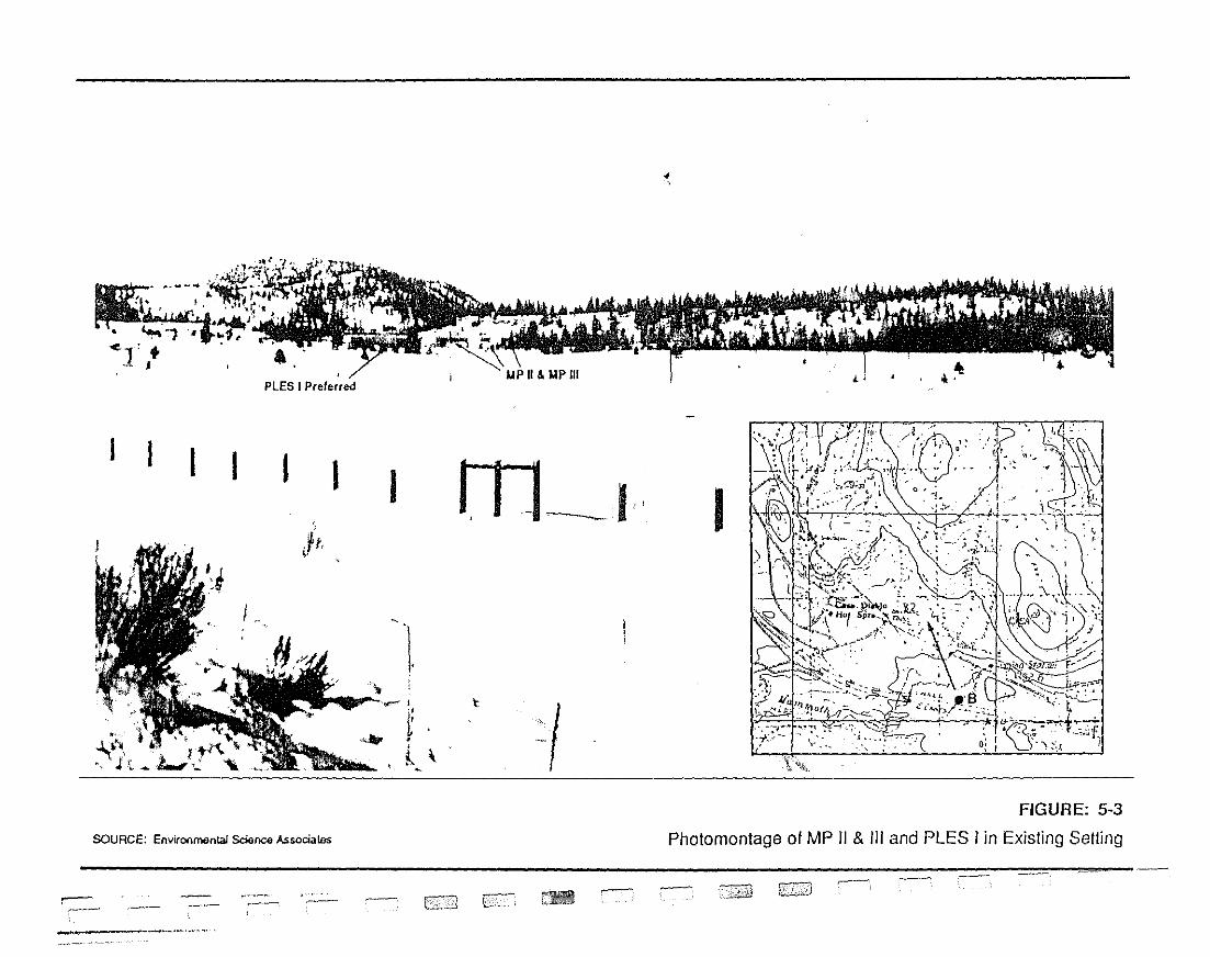
- - - - - - - 3 ! -
-
U ::T
0 0 3 0 ::J Ei <0 CD 0 - s: u
1- 90 OJ ::J Q
.
U r m C/)
~'?-'
.::J m x
::!l~~
C)
::Jc:
co:0
C/)
fl:l~
01::J
,<
0W
(1~
"J;<
ch
,i.
"JJ
\
()
r'
!" m ~ < ".
1Ig i ~ ~
j1~ ~ ~ s
r~. f
f 4'ill
} ,,.r·'''~,;,;,-
••,.
?•.
.'*'
ff
5. Overview of Impacts
northbound Highway 395 near the Mammoth Creek crossing. The scattered trees provide
some screer,ing and interruptions in what would otherwise be an aImost continuous row of
power plants in the background views across the meadow.
The PLES I project, proposed for a site across the road from the proposed MP II & lIJ site,
would add man-made elements to the landscape at the expense of natural features. The
existing and proposed facilities are close enough to one another that, in views from
Highway 395 and State Route 203, all four power plants and large portions of the other
geothermal facilities for each operation would be in the same field of view. The
cumulative visual effect of the project, in combination with the existing MP 1 and the
proposed PLES I, may be to create an industrial park appearance. Any of the mitig,nion
measures suggested in Section 4.1.3.1, if adopted, would reduce the project's contribution
to this cumulative impact. In addition, siting the MP II & lIJ plant farther from the other
existing and proposed facilities, assuming that the visibility of the site and the visual
quality of the alternative site were comparable to the existing site, would decrease this
cumulative effect in direct proportion to the distance between the power plants.
5.3.3.2 Socioeconomics
5.3.3.2.1 General Socioeconomic Impacts
Five additional geothermal electric generating plants currently proposed for the Casa.'
Diablo/Hot Creek areas are each sized to produce about 10 megawatts of electricity,
similar to the operational Mammoth Pacific I geothermal project. The socioeconomic
cumulative impacts are expected to be approximately four times as great. Attendant
with the population increases and more intensive land uses that accompany geothermal
development would be increased demands on public services and housing. Simultaneous
construction of two plants could tighten the housing market and the cumulative public
service demand would probably pass a "threshold" level and require the addition of fire,
police and school personnel.
5.3.3.2.2 Land Use and Planning 1
II
Continuing geothermal resource development within federal and private lands in the Long.1
Valley will affect land uses directly by transforming several undeveloped areas to
5-14
InI \Ii1 .. \1
]\
ji
]
5. Overview of Impacts
industrial uses. Geothermal development under environmental review by Mono County at
Casa Diablo is consistent with Mono County and !nyo Forest Plans except for the Visual
Management Objectives for the area. A total 30 to 35 acres of open space and grazeland
are lost in the development of the proposed Casa Diablo geothermal projects (MP II & TIl,
PLES I).
5.3.3.3 Recreational Resources
It is unlikely but possible that cumulative development of geothermal plants would deplete
the springs at Hot Creek Gorge and cause the loss if its recreational value. Temporary
impacts to the trout fishing in Manunoth Creek could occur if a major spill of geothermal
fluid caused thermal shock to the fish. Depletion of the hot springs at Hot Creek
Hatchery is also unlikely and could be mitigated by supplying hot water from another
source ..
5.3.3.4 Timber Resources
Construction of PLES I and MP II & III would result in the clearing of up to 18 acres of
timber. At stocking rates of 24,000 board-feet/acre, a total of 432,000 board-feet of
merchantable Jeffrey pines would be harvested.1
15.3.3.5 Range Resources 4
\
\
Up to 41 acres of land would be removed from use as rangeland by construction of MP II &
III and PLES I. This represents approximately 7 AMs. About 12 acres are private property
and, although used at the same level of intensity as the USFS land, they are not part of
the allotment.
5.3.3.6 Cultural Resources
A total of six geothermal power generation plants of similar size either exist or are
proposed for the area. These six plants are MP I, MP II & III, PLES I and
Mammoth/Chance I and II. Their cumulative adverse impacts would be greater than for
anyone facility. These impacts include, but are not limited to, cultural resource site
disturbance and/or total si te destruction.
5-15
5. Overview of Impacts
Without a program of identification of the cultural resources existing within the entire
geothermal development project area, it can be assumed that some type of disturbance
andlor destruction of cultural resources will occur. Cultural remains are non-renewable
resources and the incompatibility of these sites and proposed geothermal development will
remain a significant factor within the area. As geothermal development of the region
increases, it will become more difficult to relocate construction sites and access roads to
avoid potential adverse impacts to identified cultural resources. In turn, the only
alternative that remains is a comprehensive, systematic data recovery plan of these
cultural resources sites and this, in and of itself, results in the ultimate destruction of the
site.
Upon the preliminary siting of future facilities, an on-site inspection, evaluation, and
mi tiga tion of any identified areas of cuI tural resource significance should be made
mandatory prior to the commencement of construction activities.
5.3.3.7 Transportation and Access
If more than one geothermal plant is under construction at one time, State Route 203 east
of Highway 395 and Hot Springs Road could become congested. Operational traffic from
all three plants is unlikely to affect service near Casa Diablo.
.>
5-16
I
I]
I
6.0 Agencies, Organizations, and Individuals Consulted
6.0 AGENCIES, ORGANIZATrONS, AND INDrvrDUALS CONSULTED
The following public agencies, private organizations, and individuals were consulted to
obtain information for preparation of this environmental impact report.
6.1 PUBLIC AGENCIES
6.1.1 FEDERAL
Bureau of Land ManagementTerry Russi, Wildlife BiologistMark Ziegenbein, Geologist
u.S. Geological SurveyJ. LangbeinRoss SteinMichael Sorey, HydrologistChristopher Farrar, Hydrologist
II
IIIII
u.S. Forest Service, Inyo National ForestMark Clark, HydrologistTina Hargis, BiologistJ. Lloyd, Developed Sites ForemanClinton McCarthy, BiologistVernon McLean, GeologistM. Morse, Recreation OfficerLinda Reynolds, Forest ArchaeologistRobert L. Rice, Forest SupervisorE. B. Rickford, Forest Landscape Archi teetBob Wood, Winter Sports Specialist
U.S. Fish and Wildlife ServiceEd LorentzenR. Porter, Resource OfficerJack Williams
6.1.2 STATE OF CALIFORNIA
Air Resources BoardPaul AllenRobert MaxwellNorma Montey
6-1
.'

6.0 Agencies, Organizations, and Individuals Consul ted
Department of Fish and GameJames L. Eichmann, Manager Hot Creek HatcheryPhilip Pister, Fisheries BiologistThomas Blankenship, Wildlife BiologistRonald Thomas, Wildlife Biologist
Department of Transporta tionJack Edell, Environmental Planner,James Racine, Environmental Planner
Lawrence Berkeley LaboratoryH. Wolenberg, Geochemist
Regional Water Quality Control BoardCurt Shifrer
U.C. DavisBurgess Kay, Botanist
U.C. RiversideRoger Atkinson
6.1.3 COUNTY OF MONO AND LOCAL SPECIAL DISTRICTS
Daniel Lyster, Director Energy Management DepartmentLee McCulloch, Assessor's OfficeEllen Hardebeck, Great Basin Air Pollution Control DistrictWilliam Cox, Great Basin Unified Air Pollution Control DistrictThoms Jacobsen, Administrator, Mammoth Lakes School DistrictBruce Malby, President, Board of Directors, Long Valley Fire
Protection DistrictMarilyn Martin, Secretary to the Superintendent, Mammoth School DistrictTerry Padilla, Sergeant, Mono County Sheriff's OfficeBrian Hawley, Planning Director, Town of Mammoth Lakes
6.1.4 OTHER LOCAL AGENCIES
City of Los Department of Water and PowerB. Tillman, Biologis t
6.2 PRIVATE ORGANIZATIONS
Pacific Lighting Energy SystemsDonald L. Vinson, Director of ProjectsMichael Walker, Manager of Operations
Environmental Management Associates, Inc.Terry L. Thomas, Vice President
Mammoth Pacific I Geothermal PlantWilbert Asper, Manager
6-2
.<
l~11
1]
]1
1
1
6.0 Agencies, Organizations, and Individuals Consulted
Mesquite GroupDon Campbell, Reservoir EngIneerSkip Matlick, Geologist
Razon Associa tesG. Milliken
Pacific Gas and ElectricKen Divittorio, Department of EngIneering Research
Santa Fe Minerals, Inc.R. W. Potter, Geochemist
Southern California EdisonJohn Robinson, Area Manager
.<
6-3
7.0 Report Contributors
This report was prepared under contract to the County of Mono by Environmental Science
Associates, Inc. (ESA). Berkeley Group Incorporated (BGI) prepared the hydrology report
which was used as a basis wr the hydrology sections in the body of this EIR.
7.0 REPORT CONTRIBUTORS
ESA and BGI staff contributing to this report are as follows:
j
I j
) j
] j
) j
]j
j
I Ij
j
j
j
] j
JjJ j
1j
j
j
..
Ms. Nona DennisDr. Mark WinsorMs. Sandra GuldmanMs. Sandra GuldmanMr. Peter PyleMs. Sandra GuldmanMr. Kristian MacoskeyMr. Kristian MacoskeyMr. Gregg MillerMs. Noriko KawamotoMr. Glen ElderMs. Vanessa HawkinsMs. Vanessa HawkinsMr. Bruce CampbellMr. Yuki KawaguchiMs. Kim GardnerMs. Elizabeth Person
7-1
Officer-in-ChargeAssocia te-in-ChargeProject ManagerGeologyHydrology
Meteorology/Air QualityNoiseTerrestrial BiologyAqua tic BiologySocioeconomics/Public ServiceLand Use and PlanningRecrea tionVisualCartographyWord Processing
1
1i
l1
B.O References Cited
B.O REFERENCES CITED
Airola, D. Ed. 19BO. California Wildlife/Habitat Relationships Program. NortheastInterior Zone. U.S. Forest Service.
Allen, Paul - California Air Resources Board, Modeling Division. 19B7. Telephoneconversa tion - July 2, 1987.
Asper, Wilbert, General Manager - Mammoth Pacific I Geothermal Plant. 1987a.Telephone Conversation - January 30, 1987.
Asper, Wilbert, General Manager - Mammoth Pacific I Geothermal Plant. 1987b.Telephone Conversation - January 29, 1987.
Asper, Wilbert, General Manager - Mammoth Pacific I Geothermal Plant. 19B7c.Telephone Conversation - April 21, 1987.
Atkinson, Roger - Professor, University of California - Riverside. 1987. Telephoneconversa tion - July 2, 1987.
Bureau of Land Management. 1986b. Environmental Assessment Serial NumberCA-017-P006-37. Bishop, California.
Bolt, Beranek, and Newman. 1971. Noise from Construction Equipment and Operations,Building Equipment, and Home Appliances. U.S. Environmental Protection Agency.
Bureau of Land Management. 19B1. Environmental Assessment Serial NumberCA-010-1790-3. Mammoth Pacific, Magma Project Environmental Assessment.
J
]Bureau of Land Management. 1986a. Environmental Assessment Serial NumberCA-017-P006-41. Mammoth Pacific, Magma Project Environmental Assessment.California.
Bishop,.4
1
j
II\
Bureau of Land Management. 1986c. Fish and Wildlife Acquisition Needs. Sacramento,California.
California Department of Water Resources. 1967. Investigation of Geothermal Waters inthe Long Valley Area, Mono Countv. Sacramento, California.
California Department of Water Resources. 1973. Mammoth Basin Wa ter ResourcesEnvironmental Study (final report). Sacramento, California.
California Energy Commission. 1986. 1986 Electricity Report. Prepared by theAssessment Division with assistance from the Development Division, Siting andEnvironmental Division, and Conservation Division. PI06-87-001.
California State Air Resources Board. Aerometric Data Division. 1986. Califoria AirQuality Data: Summaries of Air Quality Data (1981-1985). Volumes XIII - XVII.Sacramento, California.
8-1
8.0 References Cited
California State Board of Equalization. 1982-1986. Taxable Sales in California. FirstQuarter 1982-Second Quarter 1986. Sacramento, California.
California State Department of Finance Population Research Unit. 1987. State andCounty Population Estima tes to July 1, 1986 (Provisional). Report 86E-2. January 1987.Sacramento, California.
California State Employment Development Department. 1983-1986. California LaborMarket Bulletin. January 1983-0ctober 1986. Sacramento, California.
Call, M.W. and C. Maser. 1985. Wildlife Habitats in Managed Rangelands--The GreatBasin of Southeastern Oregon Sage Grouse. Gen Tech Rep PNW - 187. U.S. ForestService Pacific Northwest Forest and Range Experiment Station. Portland, Oregon.
Connell, J.R. and H.W. Church. 1978. Recommended Methods for EstimatingAtmospheric Concentrations of Hazardous Vapors after Accidental Release Near NuclearReactor Sites. Report NUREGICR-1152, prepared for USNRC. Sandia Laboratories,Albuquerque.
Cox, William - Deputy Air Pollution Control Officer, Great Basin Unified Air PollutionControl District. 1987. Telephone Conversation - January 22, 1987.
Cuniff, Patrick, F. 1977. Environmental Noise Pollution. John Wiley and Sons. NewYork.
Dobbins, Richard A. 1979. Atmospheric Motion and Air Pollution. John Wiley and Sons,New York.
Earth Metrics, Inc. 1984. Mammoth Lakes Housing Study Needs. Burlingame, California.
Eccles, L. A. 1976. Sources of Arsenic in Streams Tributarv to Lake Crowley,California. U.S. Geological Survey, Water Resources Investigations Report 76-36, p. 39.
Eichmann, James, Manager - Hot Creek Ha tchery. 1987a. Telephone Convhsation -January 27 , 1987.
Eichmann, James, Manager - Hot Creek Hatchery. 1987b. Telephone Conversation -April 1, 1987.
Eichmann, James, Manager - Hot Creek Hatchery. 1987c. Telephone Conversa tion -April 27, 1987.
Farrar, C. D., M. L. Sorey, S. A. Rojstaczer, C. J. Janik, R. H. Mariner, T. L. Winnett, andM. D. Clark. 1985. Hvdrologic and Geochemical Monitoring in Long Valley Caldera, MonoCounty, California, 1982-1984. U.S. Geological Survey Water Resources investigationsReport 85-4183.
Farrar, C. D., M. L. Sorey, S. A. Rojstaczer, C. J. Janik, R. H. Mariner, T. L. Winnett, andM. D. Clark. 1986. Hydrologic and Geochemical Monitoring in Lonq Valle\! Caldera. MonoCounty, California, 1985. U.S. Geological Survey Open File Report 86-xxxx. Not yetapproved for publica tion.
8-2

in; ji
1!
8.0 References Cited
Fullerton, F.C., Director - California Department of Fish and Game. 1976. LetterDecember 22, 1976.
GeothermEx, Inc., 1986. Evaluation of the Geothermal Energy Potential In .the CasaDiablo Area of Long Valley, California.
Grosjean, Daniel and Kochy Fung. 1984. "Hydrocarbons and Carbonyls in Los AngelesAir." Journal Air Pollution Control Association, v.34, n.5, p.537-543, May 1984.
Hall, M.C. 1986. Draft Report on Archaeological Investigations at Site PLES-l(FS-04-52-870) and a Cultural Resources Survey of Adjacent Properties near Casa DiabloHot Springs, Mono County, California. Prepared for Carey and Thomas EnvironmentalManagement Consultants by Far Western Anthropological Research Group, Inc. Davis,California.
Hardebeck, Ellen. 1987. Great Basins Unified Air Pollution Control District. TelephoneConversation - January 21,1987.
Hawley, Brian, Planning Director - Town of Mammoth Lakes. 1987. TelephoneConversation - January 30,1987.
Hill, D.P., Roy A. Bailey, and Alan 5. Ryall. 1985. Active Tectonic and MagmaticProcesses Beneath Long Valley Caldera, Eastern California: an Overview. Journal ofGeophysical Research, 90 (Bl3): 11,111-11,120. November 10, 1985
Holland, R.F. 1986. Preliminary Descriptions of the Terrestrial Natural Communities ofCalifornia. California Department of Fish and Game. Sacramento, California.
Holzworth, George C. 1972. Mixing Heights, Wind Speeds, and Potential for Urban AirPollution Throughout the Contiguous United States. Office of Air Programs PublicationNo. AP-I01. Envirorunental Protection Agency, Research Triangle Park, North Carolina.
Honour, Water W. 1979. Honour's Energy and Environmental Handbook. TecbnomicPublishing Company, inc. Westport, CT.
fugles, L.G. 1965. Mammals of the Pacific States. Stanford University Press. Stanford,California.
Jacobsen, Thomas, Administrator - Mammoth Lakes Hospital District. 1987. TelephoneConversation - January 26, 1987.
Julian, F.R. and S.A. Sipkin.Area, California. JournalNovember 10, 1985
1985. Earthquake Processes in the Long Valley Calderaof Geophysical Research, 90 (B13): 11,155-11,169.
II\
II
Kucera, Thomas - Wildlife Biologist. 1987a. Meeting - January 12, 1987.
Kucera, Thomas. 1987b. Casa Diablo Geothermal Development Project: Deer MigrationStudy, Spring 1987.
Lawrence Berkeley Laboratory. 1984. Proceedings of the Workshop on Hydrologic andGeochemical Monitoring in the Long Valley Caldera, (LBL-20020J.
8-3
8.0 References Cited
Letter to Ellen Hardebeck, GBUAPCD - June 16, 1987
McCarthy, Clint, Biologist - U.S. Forest Service. 1987a. Meeting - Januarv 9, 1987.
1987.
1987a.
1987b.
Telephone1987.Service.
1987c. Telephone Conversation -
ForestU.S.Lloyd, J., Developed Sites ForemanConversation - January 27,1987.
Lyster, Dan, Director - Energy Management Department, County of Mono.Telephone Conversation - January 20, 1987.
Lyster, Daniel, Director - Energy Management Department, County of Mono.Telephone Conversa tion - February 2, 1987.
Martin, Marilyn, Secretary to the Superintendent - Mammoth School District. 1987.Telephone Conversation - January 26, 1987.
Malby, Bruce, President - Board of Directors, Long Valley Fire Protection District.1987. Telephone Conversation - February 3, 1987.
Mariner, R. H., and 1. M. Willey, 1976. Geochemistry of Thermal Waters in Long Valley,Mono County, California. Journal of Geophysical Research, v. 81, pp. 792-BOO.
Mammoth Pacific. 1986. Use Permit Application No. 01E-86-02. Submitted to Countyof Mono Department of Energy Management.
8-4
Maxwell, Robert - California Air Resources Board, Aerometric Data Division.Telephone conversation - July 2, 1987.
Lyster, Daniel, Director - Energy Management Department, County of Mono. 1987c.Telephone Conversation - June 3, 1987.
Linker, M. F., J. O. Langbein, and A. McGarr. 1986. Decrease in'Deformation RateObbserved by Two-Color Laser Ranging in Long Valley Caldera. Science, v. 232, pp.2/3-2/6.
McCarthy, Clint and C. Hargis. 1984. Analyzing Wildlife Habitats at the Proie!:t Level:An Evaluation Method. The Wildlife Society, Cal-Neva Wildlife Transactions.
McCarthy, Clint, Biologist - U.S. Forest Service. 1987b. Letter to Vern McLean April 10, 19B7.
McLean, Vernon, Geologist - U.S. Forest Service. 1987. Telephone Conversation April 14, 1987.
McCarthy, Clint, Biologist - U.S. Forest Service.April 20, 1987.
McCulloch, Lee, Assessor - Mono County. 1987. Telephone Conversation - January 27,1987.
1
Ii
\
I
I1
j
I
]
I
8.0 References Cited
Merrill and Seeley, Inc. 1981. Geological Resource Inventory: an Evaluation ofLandslide, Seismic and Volcanic Hazards in the Inyo National Forest. Submitted to theSouth Central Zone Contracting Office, U.S. Forest Service, Inyo National Forest. Merrilland Seeley. Inc. Project No. 8680. Hayward, California.
Mesquite Group, inc. 1986. Final Report on Well SF 35-32, Casa Diablo Geothermal FieldExplora tion.
Millikan, G., Attorney - Razon Associates. 1987. Telephone Conversation - January 27,1987.
Mono County Planning Department. 1981a. Noise Element of the General Plan.Bridgeport, California.
Mono County Planning Department. 1981b. Final Environmental Impact Report for theMono County Scenic Highways Element. Bridgeport, California.
Mono County. 1986. Final Budget 1986-1987. Bridgeport, California.
Morse, M., Recreation Officer - U.S. Forest Service. 1987. Telephone Conversation January 27, 1987.
Moyle, Peter B. 1976. Inland Fishes of California. University of California Press,Berkeley, California.
Novak, Patti, Chairman - Subcommittee on Revegetation, Owens Valley InterAgencyCommittee. 1986. Letter to Dan Lyster - November 3,1986.
Oliver, William and Robert Powers. 1978. Growth Models for Ponderosa Pine: Yield ofUn thinned Plantations in Northern California. USDA Forest Service Pacific SouthwestForest and Range Experiment Station. Research Paper 133.
•Pacific Gas and Electricity. 1986. The Distribution and Abundance of WildlifePopulations in Relation to Geothermal Development: Final Report. PG&E, San Ramon,California.
Pacific Lighting Energy Systems. 1986. Plans of Operation, Development, Injection, andUtilization, PLES 1-10 MW (net) Binary Power Plant Projects. Commerce, California.
Pacific Lighting Energy Systems, 1987. Plan of Baseline Data Collection PLES I 10 MWe (net) Binary Power Plant Project.
Padilla, Terry, Sargent - Mono County Sheriff's Office. 1987. Telephone Conversation January26, 1987.
Porter, R., Resource Officer - U.S. Forest Service. 1987. Telephone Conversa tion January 28, 1987.
Racin, James A. and Thomas Dayak. 1986. Revegeta tion of Highwav Slopes in the HighDesert with Native Plant Seedlings: Interim Report. California Department ofTransporta tion. Sacramen to, California.
Reynolds, Linda, Forest Archaeologist - Inyo National Forest. 1987. TelephoneConversation - March 9, 1987.
8-5
Robinson, John, Area Manager - SCE Mammoth Lakes. 1987. Telephone Conversation May 4, 1987.
Sorey, M. 1., R.E. Lewis, and F.H. Olmsted. 197B. The Hydrothermal System of LongValley Caldera. California. U.S. Geological Survey Professionl Paper 1044-A.
Rickford, E.B., Forest Landscape Architect - Inyo National Forest. 1987. TelephoneConversation - March 27,1987.
Shevenel, 1. C. O. Grigsby, F. Goff, N. O. Jannik, and F. Phillips. 1986. Mixing andBoiling of the Thermal Fluids in Long Valle\> Caldera, California. In press.
I j
J j
) j
1 j
J j
Jjj
j
Ijj
j
j
j
j
I j
J j
J j
.1 j
. J j
Second..
8.0 References Cited
Biotic Assessment for ProposedSprings, Mono County, California.
1973. Work is Dangerous to Your Health.
8-6
Water-quality Appraisal of Mammoth Creek and Hot Creek, MonoU.S. Geological Survey Water Resources Investigation Report,
Schomer, P. D. et a!. 1976. Cost Effectiveness of Alternative Noise Reduction Methodsfor Construction of Family Housing. NTIS AD/A-02B 922.
Setmire, J. G. 1984.County, California.84-4060.
Sorey, M. 1. 1976. Potential Effects of Geothermal Development on Sprir,gs at the HotCreek Fish Hatchery in Long Valley, Mono County, Calfironia. U.S. Geological SurveyOpen File Report 75-637.
Sorey, M. 1. 1987a. U.S. Geological Survey. Personal Communication - February 1987.
Sorey, M. 1. 1987b. U.S. Geological Survey. Telephone Conversation - June 4, 19B7.
Sorey, M. 1. and M. D. Clark. 1981. Changes in the Discharge Characteristics of ThermalSprings and Fumaroles in the Long Valley Caldera, California. Resulting from Earthguakeson May 25-27, 1980. U.S. Geological Survey Open File Report 81-203.
Stebbins, R. C. 1985. A Field Guide to Western Reptiles and Amphibians.Edition. Houghton Mifflin. Boston.
Stellman, Jeanne M. and Susan M. Daurn.Vintage Books, New York.
Taylor, Dean W. and Richard Buckberg. 1987.Geothermal Energy Facilities, Casa Diablo Hot
Thomas, ..R. D. 1986a. Management Plan for the Sher""n Grade Deer Herd. CaliforniaDepartment of Fish and Game.
Thomas, R. D. 1986b. Casa Diablo Deer Herd Management Plan. California Departmentof Fish and Game.
Thomas, Terry R., Vice President - Environmental Management, Associa res, lnc. 1987.Letter - February 6, 1987.

1'I "1
'I :,,i
I! "j
8.0 References Cited
Tillman, B., Biologist - Los Angeles Department of Wa ter and Power. 1987" TelephoneConversa tion - January 27, 1987.
Tumer, D. Bruce. 1970. Workbook of Atmospheric Dispersion Est1ma tes. U.S.Department of Health, Education, and Welfare, Cincinnati, Ohio.
Turpen, C. D. 1980. Strong-motion Instrumentation Program Results from the May 1980Mammoth Lakes Earthquake Sequence. California Dic-ision of Mines and Geology SpecialReport No. 150. Sacramento, California.
U.S. Environmental Protection Agency. 1974. lnformation on Levels of Em>ironmentalNoise Requisite to Protect Public Health and Welfare with an Adequate Margin of Safety.Report No. 55019-74 004. Washington D.C., March 1974.
U.S. Fish and Wildlife Service. 1986. Endangered and 11lreatened Wildlife and Plants.January 1,1986. 50 CFR 17.11 and 17.12.
U.S. Forest Service. 1974. National Forest Landscape Management. 2 volumes.
U.S. Forest Service. 1980. Environmental Assessment. Leasing of Na tional Fores t Landsfor Geothermal Explorations in the Long Vallev Caldera. Bishop, California.
U.S. Forest Service. 1986. Draft Environmental Impact Statement. Forest Land andResource Management Plan. lnvo National Forest. Bishop, California.
U.S. Geological Survey, Conservation Division. 1976. Geothermal Resources OperationalOrders. Issued under the Geothermal Steam Act of 1970.
Van Ulden, A.P. 1974. "On the Spreading of Heavy Gas Released Near the Ground" inC.H. Buschmann, ed., Loss Prevention Svmposium. Elsevier, Amsterdam.
WESTEC Services, lnc. 1986. Draft Environmental Impact Report - Mammoth/ChanceGeothernial Development Project. 2 Volumes. Project No. 36037001. San. Diego,California. "
Walker, Michael, Manager of Operations - Pacific Lighting Energy Systems. Letter 10
Ellen Hardebeck. GBUAPCD - June 16, 1987.
8-7

]
]
]
]
]

1-'
II1!
"
1;
···1'
1 ;
APPENDICES
. ,
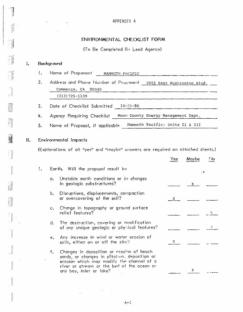
11
IiAPPENDIX A
ENVIRONMENTAL CJ-fECKLlsT FORM
(To Be Compleled 8v Lead Agency)
. Bockground
I. Nome of Proponent
I
I.
2.
MA!1HOTH PI'CIFIC
Address ond Phone t~ulnber of Prul!'ment
Commerce, CA 90040
(213) 725-1139
2055 East Wilshington Blvd.
3. Dote of Checklist Submit led 10-21-86------------------4. Agency Requiring Checklist Mono County Energy Management Dept.
5. Nome of Proposal, if applicabl" l1ammoth Pacific: units II & III
II. Environmental IIT4>OCls
(Explanations of all "yes" and "rnoyb~" ullswers ore required on oltod,"d sheets.)
J
I
]
1• Earlb. Wi II Ihe proposal resull ill:
a. UnSlable earth condil ions or i'1 changesin geologic subslruclures?
b. Disruptions, displacements, COlllpaclionor overcovering of Ihe soil?
c. Change in topogrophy or ground surfacerelief features?
d. The destruclion, covering or modifical ionof any unique geologic or phy·:ical feotures?
e. Any increase in wind or watN erosion ofsoils, either on or off the sile'!
f. Changes in deposition or F'rosirm of beachsands, or changes in sillal,pn. d"position orerosion which may modify II", channel of ariver or strPClfn or Ih" bed of Ihe ocean orany boy, inlet or lake?
A-I
Yes
x
x
Maybe
x
x
•

],I
11
]1 2.
g. Exposure of people or property 10 geolo-gic hazards such as eorthquaKc:',. lands lides,mudslides, ground failure, "r ,i"lilar hazards?
Air. Will the proposal result in:
a. Substantial air emissions or deleriorotionof ambient air quality?
b. The creation of objectionable "dors?
c. Alteration of air movement, ",,,isture, ortemperature, or ony chanqe in climate,either locally or regionally?
Yes
x
Maybe
x
x
r '0
x
3. Water. Will the proposal result in:
a. Changes in c\Jrrents, or the c"urse of direction of water movements, ill eithermarine or fresh waters?
b. Changes in absorpt ion rates, rJroinoge patterns, or the role and arnou"t of surfocerumff?
c. Alterations to the course or flow of floodwaters?
d. Change in the amount of surface water inany water body?
e. Discharge into surface waters, or in anyalteration of surface water quality, including but not lirnited to lcmiJerature,dissolved oxygen or turbidity'?
f. Alteral ion of the direction o~ rate of flowof ground waters?
g. Change in the '1uontity of groulld wafers,either through direct additions or withdrawnls, or through intercept ion of an0fltlifp.r hy CIJt~ or excavul ions'!
h. Substantial rp<.hr.tion in the anlOunt ofwater otherwise availoble for puhlic wotersup[) lies?
x
x
.<
x
x
x
x
I. Exposure of renple or prr,,'erl v to water related hazards such as flo,,,li<.K) or tidal waves?
A-2
..:

I.I'
II
Ii
j
J
\.
4. Plant Life. Will the proposal r",·oIt in:
o. Change in the diversit y of Sf'L-<: ies, ornumber of ony species of pl,,,'IS (including1rees, shrubs, gross, crops, (\'1': oqlKJticp 10111 s)?
b. Reduction of the numbers of ""y unique,rore or endangered specie, 0; ~Iants?
c. Introduction of new species .. r plants intoon area, or in a barrier t" th· normalreplenishment of exisling ~rH:cles?
d. Reduction in acreage of (]ll;' IYJriculturalcrap?
5. Animal Life. Will the proposal r<'5ult in:
a. Change in the diversity of sf,,:cies, ornumbers of any species of alli,nals (birds,land animals including reptile~, fish andshellfish, benthic organisms or insects)?
b. Reduction of the numbers of allY unique,rare or endangered >pecies of animals?
c. Introductim of new species of mimals intoon area, or resull in a barrier to themigration or movement of alimals?
d. Deterioration to existing fish or wildlifehabilat?
6. Noise. Wi II the proposal result in:
a. Increases in existing noise levels?
b. Exposure of people to severe noise levels?
Yes
x
x
__x_
Maybe
x
x
x
.'
y.
")0
x
__x__
7.
8.
Light and Glore. Will the prorosnl producenew light or glare?
Land tise. Will th" rrorosal resull in a substanlial allerolioll of Ihe preselll or plannedland use of on area? y.
9. Notural ResOlIrces. Will the Olropo:;ol result in:
a. Increase in the rate of use of any naturalresources?
A-3

I,'
I]I!
I
'-
b. Subsfontiol deple1ion of any nonrenewablenofurol resource?
10. Risk of Upset. Will file proposal invulve:
a. 1\ risk of on expll1~ion or j/>p' rel~se
of hozoruous sub~fonces (includirY~1 Out no!limited to, oil, pesticides, chemi'::ols orradial ion) III fll" event of on acciden! orupset conui! ions?
b. Possible interference wi11l an ernprgencyresponse plan or on emergency e"ocua1ionplan?
II. Population. Will the propo~ol oliN Il'e location,distribu1ion, d"nsity, or growfh role ef fhehuman populol ion of an area?
/2. Housing. Will 1he prnposal offP{'t exi<ling housing, or create a demand for oddi Iionol housing?
13. Transpor1alion/Circulaliofl. Will the ['roposolresu Itin:
o. Grnprofion of s""~I,,nfiol oudilion"lvehicular movelnenl?
b. F.ffpcl~ on existin'1 p(lrking hcilities, ordemand for new par king?
c. Suhslantial irllJOC! upon exislinlj Iransporfa t ion sy sl ems?
d. Alteralions fa prespnl pattnl'" nf circulation or movemen! of people and/or goods?
e. Alteralions fa waterborne, ruil 01 orrtroff ic?
f. 1,r-rPOs", in trorfi,' 1''1cord< In mnlorvehicles, bicyclisls or pedes!1 ions?
14. Puillic Servicp.s. Will fI", propn<,,1 Il,J'/f~ oneffect upon, or resull in 0 need ior new oraltered governmental services in any of fhefollowing areas:
a. Fire protect ion?
b. Police prolection?
c. Scll'Y'ls?
A-4
Yes
x
x
x
x
Maybe
x
::
No
x
x
x
Y.
x
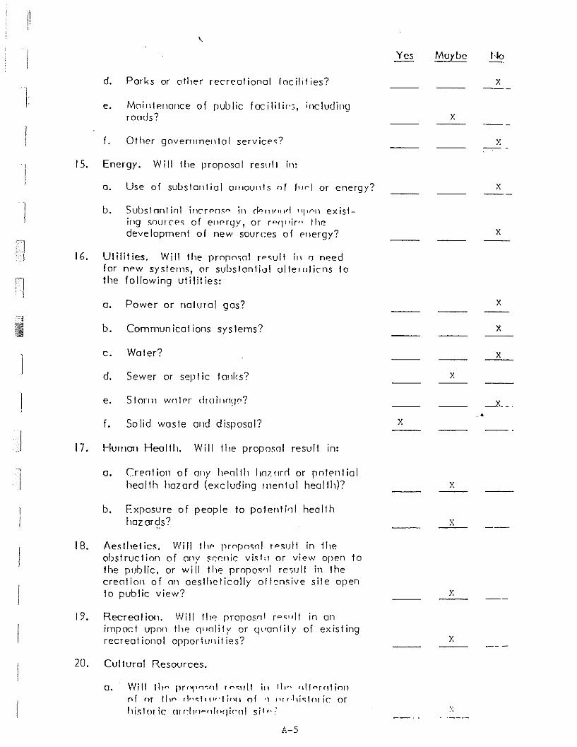
Id. Parks or other recrealional fnclld ies?
e. Moilllf'llallce of [Jublic focilili"o, includillQroods?
Yes Muyl>c
x
1-10
x
f. Ot her gavernrnell I01 serv icps? x
15. Energy. Will Ihe pro[Josal res\l11 in:
o. Use of subslolliiol orlloulds of f"01 or energy?
b. SubSlnntinl illCfPosn ill r!nfllr11ld 1111('\1) existing snUITP<; of erH"rc,JY, or fpqllir" thedevelopment of new sources of f'llergy?
16. Utilities. Will the prnrnsnl rpsult ill n needfor nf'W systems, ar subslonliul ullel<Jli,ns tothe following utilities:
a. Power or natural gas?
b. Cammun icot ions sys terns?
c. Woler?
d. Sewer or sepl ic tOllks?
e. 5101"111 wnlpr dr(Jill(l~W?
x
x
x
x
x
x---
f. Solid wasle alld disposal? x..
17. Human Health. Will the proposol result in:
a. (reotion of OilY "pollh h07.mrl or polE'ntialhealth hazard (excluding Illenful heallh)?
b. Exposure of people to patenti'11 healthhazards?
18. Aesthetics. Will th" I'rnpnsol rpsull in fheobstruction of (my scp.nic vis!" or view open fathe public, or will the prn[Jos'r! ",,;ull in thecreolian of on aesthetically alknsive site opento public view?
x
x
x
19. Reereal iO<1.irn[loct U[lnnrecreat ional
Will th" [Jro[Josn l rps"lt in anthe (l"nlity or tj\'anlily of existinga[J[Jorf\Jnil ies? x
20. Cultural Resources.
o. Will 11,,... prr"f1fl":nl rf"'<;lIlt ill ill" nlfnrrllinn('1f or 11,(' rl""lllwlion of " 11l/'!li<::lo! ir. or
11i~lor ic (11 r~llfl-nl(lqir'nl Sil,,:'
P.-s
IIIII
,On the basis of this initial evaluation:
I find that the proposed project COULD NOT have a significant effect I-Ion the environment, and a NEGATIVE DECLARATiON will be prepared.
I find that although the proposed project ('ould have a significant effecton the environment, there will not be a ~ilJnificant effect in this casebecause the mitigation measures described on on oltached ~heel hovebeen odded to the project. A NEGATIVE DECLARATION WILL BE PREPARED.
I find the propo~f'd rrojpcl MAY hove a sigl1ifi('ant effect on the environ- -ment' and an ENVIROhJMENTAL IMPAC I 1~r:PORT is required. I n: I
Dote
For
(Note: This is only a suggested form. Puhlic agencies are free to devise their ownformal for inil ia I studies.)
A-7

The following is a summary of annotated comments whichidentifies specific issues related to all of the "yes" and"maybe" answers to questions provided on the Initial Studychecklist discussed during the project scoping meeting ofTuesday, October 21, 1986:
n
1,]
II 1.
MAMMOTH PACIFIC II & III GEOTHERMAL PROJECTANNOTATED INITIAL STUDY ISSUES
Earth:
a. Maybe - This issue was given a "maybe" answer becauseof possible concern for water/soil erosion duringconstruction activities and the potential forsubsidence resulting from long term fluid withdrawalfrom the geothermal reservoir.
b. Yes - This issue was g~ven a "yes" answer because ofthe potential for soil disturbance during constructionand for "possible surface subsidence as a result of longterm fluid withdrawal from the geothermal reservoir.
e. Yes - This issue was given a "yes" response because ofthe potential for irlcreased wind and water erosionduring construction activities.
f. Maybe - This issue was given a "maybe" response becauseof the potential for erosion resulting from surfacewater runoff from cleared areas during construction andthe possibility for se1imentation of surface wat~rs
downstream of the project area.
g. Yes - This issue was g:ven a "yes" response because ofthe potential for exposing on-site workers to geologichazards.
2. Air:
a. "Maybe - This issue \"Ias given a "maybe" response onlybecause of the potelltial for air emissions during soweform of system upseL such as, pipeline rupture or wellblowout, and not for elcissions anticipated duringnormal operations.
b. Maybe - This issue \vas given a "maybe" response agaillonly because of the potential for objectionable odorsresul ting from hydr-lge!1 sulfide emissions which coule!occur during a syst~m l\pset such as, pipeline ruptureor well blowout, and i', not anticipated to be a concc:-nduring normal opera~ions.
A-8

~
II
MP II & III Project Initial StudyAnnotated Comments
October 23, 1986Page 2
/1
I
3. Water:
b. Maybe - This issue was given a "maybe" response, again,only because of the potential for increased runoff as aresult of an accidental spill of geothermal fluid. Nochanges are anticipated during normal operations.
d. Maybe - This issue is, again, only related to thepossibility for changes i.n surface water as a result ofrunoff from an accidental spill of geothermal fluid andis not a concern during the anticipated normaloperations.
e. Maybe - This issue was given a "maybe" response, again,only because of the potential for discharge into theephemeral stream located within the project area as aresult of an accidental spill of geothermal fluid.Discharge is not anticipated during normal operations.
II
f.
g.
Yes - This question was given a "yes" response onlybecause the project will be producing geothermal"waters" and injecting them in a new location. It doesnot refer to changes in non-thermal groundwater.
Yes - This question was g:iven a "yes" response only.because the project will be producing geothermal"waters" and injecting them in a new location. It doesnot refer to changes in non-thermal groundwater.
4. Plant Life:
a. Maybe - This question was given a "maybe" responsebecause cf the anticipatr,·d reduction in the number ofplant species that will result from constructionactivities and not becau~e of any anticipated loss ofplant diversity in the project area.
b. ~laybe - This question was given a "maybe" responsebecause the site has not yet been surveyed forsensitive species known to exist in Mono County.
c. Maybe - New species may be introduced into the areaonly as a result of rp.vegetation or site rehabilitationprograms or as part of the landscape plan for theproject.
A-9
:1,
MP II & III Project Initial StudyAnnotated Comments
October 23, 1986Page 3
c. Yes - This issue was given a "yes" response because ofthe possible impact on mule deer migration through theproject area.
a. Maybe - This question was answered "maybe" because ofthe potential for reducing the number of animal speciesin the project area not because of the potential for achange of diversity of animals species.
II
Ii
I
5. Animal Life:
d. Yes - This issue was given a "yes" response because ofanticipated habitat destruction resulting from siteconstruction and for possible effects upon aquaticanimals living in conjunction with the hot springs inthe project area and within the Hot Creek Fish Hatcherysprings.
6. Noise:
)
I
a.
b.
Yes - Past history at Mammoth Pacific Unit I indicatesnoise may be an issue.
Maybe - Noise during drilling operations and noiseduring power plant operations could be severe foron-site employees.
7. Light and Glare: Maybe - Light or glare could result fromnight lighting.
8. Land Use: Maybe - The proposed project area is currentlyzoned general purpose.
9. Natural Resources:
a. Yes - This issue was given a "yes" response becausegeothermal mineral res~urce will be utilized.
10. Risk of Upset:
a. Yes - During system upset there is a potential for arelease of geothermal fluid, isobutane, and forhydrogen sulfide e~issions.
11. Population: Maybe - A 3liJht potential exists to increas~
the local population as Q T"sult of the work force neededduring construction and pOVler plant operations.
12. Housing: Maybe - Becau~? of: the expected small populationincrease, housing demann s);·'uld be considered for both theconstruction and power rL~r." activity periods.

I
\
,
MP II & III Project Initial StudyAnnotated Comments
October 23, 1986Page 4
I13. Transportation/Circulation:
a. Yes - Vehicular traffic may be an issue for the briefperiod of proposed construction activity, but it is notan issue for the power plant operational period.
f. Yes - Traffic hazards may be an issue for the briefperiod of proposed construction activity, but it is notan issue for the power plant operational period.
14. Public Services:
a. Yes - This issue was given a "yes" response because ofthe use of the flammable hydrocarbon working fluid inthe binary power plant.
b. Maybe - This issue was given a "maybe" response becauseof the increased potential for vandalism at the powerplant site.
e. Maybe - This issue was given a "maybe" response becauseof potential impacts on old U.S. Highway 395 andCalifornia State Highway 203 from heavy equipmenttraffic.
•16. Utilities:
d. Maybe - This issue was given a "maybe" response becauseof the anticipated need for a new septic tank system atthe facility.
f. Yes - This issue was given a "yes" response because of'the necessity for disposing of drilling muds andrelated wastes.
17. Human Health:
a. Maybe - This issue was given a "maybe" response becRuseof the potential for accidental occupational exposureto the isobutane worki 1;g fluid and to hydrogen sulfid"contained within the g~othermal fluid.
b. Maybe - Again this iss!'e was given a "maybe" responsebecause of the potenti21 for occupational exposure toworkers during systpm upsets.
lB. Aesthetics: Maybe - This issue was given a "maybe" responsebecause some people may be ',ffended by the site of ageothermal power plant oper.!tion.
A-ll

il i'-
MP II & III Project Initial StudyAnnotated Comments
October 23, 1986Page 5
-,
~
19. Recreation: Maybe - This issue was given a "maybe" responsebecause of potential impacts on Hot Creek Gorge recreation(sightseeing and swimming), impacts on deer migration(impact on hunting), and impacts upon the fish hatchery(tourism) .
20. Cultural Resources:
a. Maybe - This issue is discussed in a pending culturalresource survey report for the entire project area.
b. Maybe - This issue is discussed in a pending culturalresource survey report for the entire project area. [
c. Maybe - This issue is discussed in a pending culturalresource survey report for the entire project area.
d. Maybe - This issue is discussed in a pending culturalresource survey report for the entire project area.
21. Mandatory Findings of Significance:
a. Maybe - For all of the stated reasons given above.
b. Maybe - This issue was given a "maybe" response forpotential long term impacts upon the Hot Creek GOrgeand the Hot Creek Fish Hatchery.
c. Maybe - This issue was given a "maybe" response becausethe Mammoth Pacific II and III Project is only one ofseveral small geothermal projects proposed in the LongValley area.
d. Maybe - This issue was given a "maybe" response becauseof the issue of aesthetics only.
It was decided that a focused Environmental Impact Report(EIR) should be prepared for the proposed project.
In addition to the checklist responses provided above, itwas decided at the scoping meeting that the EIR should include '3.
section on both cumulative impacts and growth-inducing impacts '3.S
required by the California Environmental Quality Act. It was alsobelieved that a discussion shouhi be included in the EIR whichdescribes the Long Valley East Geothermal Unit Area and therelationship of the proposed pro<ect to the Known GeothermalResource Area (KGRA) and the Unit Area.
A-12
1 APPENDI X B
NON-HAZARDOUS DRILLING MUD ADDITIVES
Aluminum sterate (aluminum tristearate)Attapulglte clayBagasse (dried sugar cane)Bariu m sulfateBentoniteCalcium carbonateCausticized lignite (sodium lignite)CellophaneChrome-free lignosulfonateCottonseed pelletsDiamines and fatty acid amidesDetergentsEthylene oxide adducts of phenol and nonylphenolGuar gumHydroxyethyl celluloseLecithinLigniteMagnesium oxideMethanolMicaMorpholine polyethoxyethanolNut shellsParaformaldehydePeptized bentonitePhosphoric acidPolyacrylamide resinPolyanionic cellulosic polymerPolysaccharidesPotassium chloridePotassium hydroxide (caustic potash)Potassiu m sulfa tePregelatinized corn starchQuartz or cristoballteRice hullsSawdustShredded paperSodium acid pyrophosphateSodiu m bicarbonate (bicarbonate of soda)Sodium carbonate (soda ash)Sodiu·m carboxymethylcelluloseSodiu m chlorideSodium hexametaphosphateSodium hydroxide (caustic soda)Sodium montmorillonite claySodium polyacrylateSodium tetraphosphateStarchTetrasodium pyrophosphateTributyl phosphateVegetable and polymer fibers, flakes, and granulesVinyl acetate/Maleic anhydrite copolymerZanthan gum (XC polymer)
Source: California Department of Health Services
B-1
.<
I

APPENDIX C
CASA DIABLO GEOTHERMAL DEVELOPMENT PROJECT:
DEER MIGRATION STUDY, SPRING 1987
Thomas E. Kucera
I'.,.)
I • Iu ru
Li
,.'.)
n ,""n [··1I,.j'c'"J
C-l
1conditions in the Study Area, and to assist in assessing impacts
to deer of a geothermal development and designing measures to
reduce those impacts.
ACKNOWLEDGMENTS
This investigation was conducted under a contract from
Environmental Management Associates, Brea CA. Some of the
data presented here are from a larger investigation of Eastern
Sierra deer supported by the Bishop Resource Area of the Bureau
of Land Management, the California Department of Fish and Game,
Inyo and Mono Counties, the University of California, Berkeley,
and several private funding organizations. Most of the fieldwork
was conducted by Timothy Taylor.
The data in this report are to be used solely for the
purposes of planning and analyzing potential environmental
impacts of the proposed Casa Diablo Geothermal Project, and are
not for publication, citation, or other use without the.'
permission of the author.
STUDY AREA
The Casa Diablo Geothermal Study Area is located in portions
of Sections 29 and 32 of T. 3 S, R. 28 E, Mono County, CA (Figure
2). It is immediately north of Highway 395, approximately 3 miles
east of the town of Mammoth Lakes. The land is a mixture of both
public and private ownership.
METHODS
A track survey route was laid out on the dirt roads which
pass through the Study Area (Figure 2). This route was divided
and marked into 20 sections each 0.1 miles long except Section 1,
which was 0.2 miles long. In adition, the dirt road leading from
C-5
I~
::l
~
,\ ) )';.1"'..;~
--~-------
(/-'
CASA DIABLO FIELD BASE MAP
Figure 2. Location of thedeer track sIJrvey routeand numbered surveysections, Casa Diablor,pot.hermal area.
~t,GG ,/
"-= /,-/> -:::-/--~-------
"- .~"-'l., .. """,
r ."0"'"'l....0 " 1"'''~I>~ ...{( j/ a'OIl'CC,S"<>OConI~ N'.::::::. c· S"l>ll~l"""
Of·~"CtoO...
_ I",,, 012.7) I I ... .... I
. ~., ....... ;
13S
)
nI
'"
lI
Ij
Hot Springs Road to well SF 35-32 was included in the surveys.
Beeinning on 21 April 1987, the entire route was cleared of
tracks and a tracking substrate prepared by dragging it with a
"sled" of automobile tires pulled by a vehicle. This was done in
late afternoon, and the following morning, the route was walked
or driven and all deer tracks observed on tlle road were counted,
both by survey section and by direction of travel. Data recorded
were the number of individual deer making the observed tracks and
tlleir direction of travel. Because the route was dragged each
evenine before a survey to obliterate all tracks, the tracks
counted on the surveys were made by animals within approximately
the previous 12-18 hours. Recording tracks by survey section was
designed to give a quantitative picture of the local pattern of
deer mOVEment in the Study Area. Recording tracks by direction of
movement was designed to allow separation of back-and-forth or
very localized movements from migrational movements..4
RESULTS
1. Timing of deer activity
Figure 3 shows the total number of tracks made by individual
deer throughout the period of study, presented without regard to
direction of movement. A pattern of a gradual increase in the
number of tracks throughout the period is apparent, with the
greatest number of tracks counted, 20, on 13 June.
Figure 4 shows the breakdown of tracks counted on the
surveys by direction of movement. Movements to the north and west
are generally in the direction of the spring migration; those to
the south and east west are opposite. TllUS, subtracting the
south and east-moving tracks from the north and west-moving ones,
C-7

1-1L
II I:1
+T
DlI
rL
lCT
.-
1\,...
........
.,,"......
-'
-'
t'J
r>0'
1r>
(,'1
0~.
~
i'.j
PN
'lJ
N"'
---J
W 0 ,....
'-'.
(D -'
-'
0-'
J>..
".
+:.
-1:::
.A
l-'
m.....
"-
......
VJ
N - 1',)
OJ
N (D 1'-,)
.P-
C-
-'
C0
::J m-" w
C-8
U r rn l.f)
<.Q I~ I~ 3 Al
(t)
'"'0 ...,
• Cl.
(J)
(j) '" - (j o r -
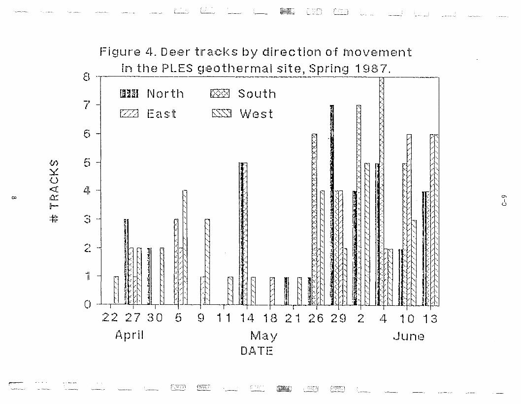
Figure 4. De,er tracks by direction o·f movemEH.... tin the PLES £!,eothermal site, Spring 1 fl8 7.
EI -,--- [,1
-,I
liJUI !'lor t I')
(//-J Ea s: it
f:'6cj Sou t h
~::::J W13 S t
;:
6 ;, -., ,
t='~)
~,
':l
.,!I
~,
.c.
C1'I
U
"',
.-j',
'I:'" .
"I",.' ".,.....' '.
"I:'" ,.' "
lfi'." ,
'I''........
... ,
10 13
Junia
4
I:'. ''\,
'.;' ,-,
rl.r~ ~I ' f':~ ~ I ' ~
~ .~ L:~: ! >: 1.t....-.. ~ , , I:· ' '. '~:I"I II: '1"t- '. .' , . - ., . i.; .' -. , '. :.'.r:,:~::: '.• : : f :; ~::: :: I:: ;::. i<f J, JJJ-LJUJ:: ;:,,« :: ::U;;f5 9 11 14 1B 21 26 2Sl 2
Mav,Dill TE
8
ii,~I"ik ,.
~. I[:llil. ", -,"D _LT~: ,:r:U~[J
:2: 2 2 7 ~3 ()
April
4-
.Cr)
~U<clet:Il-•ol'!·ttr
CD
,--
Il.,
I
!
)
respectively, yields a crude estimate of the net number of deer
moving through between ttle the dragging of tIle route and the
survey. This is shown in Figure 5, in which the number of tracks
heading south was subtracted from those heading north, and the
number of tracks heading east was subtracted from those heading
west, on each survey. NeGative nUTIlbers may be interpreted as
indicating predominantly localized, nondirectional movements. As
indicated in Ficure 5, most miGrational movements in the Study
Area occurred throughout late April and flay. Begillning in late
May, the negative net track numbers indicate fewer directional or
migrational movements and more local movements, likely from deer
on what will be their summer range.
2. Locations of deer movements
Figure 6 presents the total number of deer tracks by survey
section counted during the spring of 1987. The large number of
tracks indicated for Section 1 is somewhat misleading because.4
that section is twice as long as the others. With this in mind,
the distribution of tracks in the survey sections appears rather
uniform. The net tracks by survey section are presented in Figure
7. No consistent pattern of movements is indicated. It is
apparent that directional movements occurred in Sections 8, 10-12
and 18-20, which correspond to the most northerly and
northwesterly, and southwesterly portions, respectively, of the
Study Area.
Additionally, on the road LO well SF 35-32, single
sets of west-moving tracks were observed on 10, 18, 21 and 26
May. Throughout the survey period, only two deer were observed;
on 4 June, 2 adult females were seen near Sections 10 and 11. No
C-I0
e
Fig u 1rE~ 5. N19 t n urn b er S 0 f t rae k $ b yf d iIf ec t ion 0 f rn 0 v errHm t
in the PLES fjeotherrnal site, Sprinq 19H7.
6
{J') 4 II. ,
~2 :r<...>
«o . ~!l;Um I:~
..... 1--0
#~ r,iLlJ -"Z
-4
-6
... :,: , r k ;t
H. .~ R. 11~. ~~ .
.1,\1', .' ;~~
',lUI
..........I
U
~
,. .8 ..1,_-,-__, ,_,__, I ,--,--,----, I ,-,-
22 27 30 5 S! 11 14 18 ;2'1 ~~6 29 2 4 10 '13
.Plpril IV1aty JunE~
DJiI TE
11
:iJ:
or
--'
•
:J r ..... • C/l
()
Q C :J ..-+ ill
Q...."
(,oJ
!!:l
CDC
0- •
1'9
ID=
.0
C)
:J ~ III
(,.-"}
C/l
l.O ill o ,....;.
:J"
ill
oo L
_..L
.,..L
......
.L...
.L_J
__.
L..
!J.
.1
!!
I!
!!
!l:t:.nJma~~c;Cl.&ItIiJ;N1L:lI~~~41:J.b~~Rl1ilfM:ltb1iittlt!1~
-au:.ciili~2~t::~~Il:i1&.millJ,t;t.:i~u~~~
!'-)-~~~~~l~~~
e;::,"
'~KiWj
!ji!
;;;~t.l..
~I~I;·~·
;C;tP11.
1t1IJ',
z·~_·t
l!1m
~:~~-u:.:nn-il;;-l'c1~:,i;!~~~
W-OL;;I;:;...-:tl!:":aJr~~~.:
:.""
'lnl
.lll
Ulll
/'0
t;,
••
..lIN
k'·
·D
tM
+H
*
~ ::v < n1 -< (/)
n1 o -j o ..
.".
..::..
.
C-1
2
8
Fi9UrE~ 7. N'8i[ numbers of tracks: by survey section,
PLES 980thermal site, Spring 1987.
6
M~
IU
~
idl,~'1 ~~, . .
1~1 I:~ .1~J~~UULin PO
11~n~~~I ~~', i,~i"
'j;,'Ii '
2
4~~
I~J Jlo --\.] Utl''' -- ,~'~
1,1 i,~:j11 R!ll)' "',',J~~" tl :. -'p' -. ~, :Ii I ell . .
_2 -1'! ij~ jfIlr M'
lJ~
-4 -1 H;m'
<J')
~~U«u::
~ ~--N
•. LJI-·tf~
tI--i!J.J'-".,e:::::..
,·6
'. 8 ~-'I-'-'---'-'--'-J-,---,-r--r-,-..,-~~-..,-,-- I T
1 2 345 6 7 8 9 1011121314151617181920S[J1i VE''y' SECTION
~
specific areas of deer movement or well-defined concentration
areas were apparen~ from covering the area on foot.
DISCUSSION
Results of the spring 1987 track surveys indicate a
generally somewhat dispersed pattern of deer activity in and
movement through the Study Area. No well-defined migration trails
were observed, and the track counts indicate deer activity in all
sections. One could make the rather wealc case that Figure 7 shows
a preference for the less developed portions of the area, i.e.,
Sections 8, 10-13, and 17-20, but the data are hardly compelling.
Nevertheless, deer movement th~ough the area was apparent,
and the number of animals involved can be at least roughly
estimated. On the assumption that the period of spring migration
was 15 April to 2 June, the 12 surveys covered approximately 25%
of the "8 days in this period. The net number of tracks during
this period was 13 (Figure 5). Assuming this to be a reasonable.'
approximation of the number of deer actually moving through
between the time the road was dragged and when tracks were
COUllt.d the next morning, a total of 52 (13/0.25) deer moved
through the Study Area during the survey period. This does not
take into account those deer that may have moved through during
the day. Making the assumption that 75% of deer would migrate at
night (between draSging and counting) and 25% would migrate
during the day, a grand total of 69 ("5/0.75) deer moving through
during the spring period can be estimated, given the stated
assumptions.
This estimate of 69 deer is meant only as an approximation
of the number of deer using the Study Area on spring migration.
-.I 1
Potential sources of error, e.g., multiple counts of the same
animal, or tracks missed because of poor tracking medium, are
impossible to quantify. However, the precise number is not
important; what matters is the estimate of magnitude. There
certainly are not hundreds or thousands of animals using the
area, as is the case in other local areas, but likely there are
dozens. Tilis movement does not appear to be concentrated in any
localized portion of the Study Area, but is dispersed throughout
it, which nlay not be surprising given its relatively small area
and lack of extreme topography. It is likely that deer from three
designated "herds" are involved: the Buttermilk, Sherwin Grade,
and the Cas a Diablo herds. Radioed or otherwise marked deer from
all three herds have been observed in the vicinity of the Study
Area.
Recent radio-telemetry information indicates that, in
general, most of the Buttermilk and Sherwin Grade deer wh~ch
migrate north do so along the base of the mountains west of
HiGh~ay 395. Likewise, most Cas a Diablo deer move along the base
of the Glass Mountains north"est of the Study Area. A portion of
each herd, ho"ever, does move near or right through the Study
Area. The specifi.c areas used as migration corridors are probably
dictated as such by both local topography and tradition.
Impacts of geothermal development on these migrating deer
are difficult to predict precisely, but in a general sense are a
function both of the location, amount and kinds of changes
associated with the development, and of the availability of
potential alternate travel routes. It seems to be the case that
deer activity is rather dispersed throughout the area. The
C-15
1I
I .
locations of the proposed project facilities (Fig. 8), including
a number of proposed wells, pipelines, and a transmission line
and access road, as well as the power plant site, in general are
adjacent to the existing geothermal plant and facilities.
Assumine a "worst case" scenario, one in which deer completely
avoid the proposed facilities and associated human disturbance,
it is difficult to see how making several dozen deer move several
hundred yards around the facilities would constitute a great
hardship. Given the existing terrain, such an avoidance would
likely have a trivial impact on migrating deer. Of course,
certain facilities, e.g., fences, pipelines, etc., could be
designed to minimize any impacts to deer and to facilitate their
passage.
From the standpoint of deer migration, the locations of the
proposed facilities (Figure 8) are preferable to those of the
alternate site (Figure 9). This latter alternative would move the.'
power plant to the northeast, across Hot Springs Road, and
effectively increase the area impacted by the project. In
general, the more concentrated an area of disturbance, the less
will be its deleterious impacts.
Thus, at present, alternate routes for spring migration
exist, giiing deer an opportunity to avoid the project area if
developed. However, there are proposals for additional
developments in the region. Although it is impossible to discuss
thoroughly the impacts of a project without reference to the
context in which the project occurs, a regional summary and
analysis taking such additional projects into account are not
within the scope of the present work. No doubt the consequences
C-16
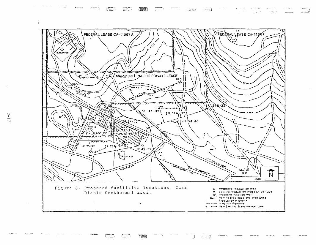
~
500:
JI ••
\\\ '\!l II\ '\:: ::::::::....JC
~ '--\!I"".:'~-........::_~ -.......:
f~\ ..57:';E ~\ N
'><--::-.1..- I.i {FEDERAL LEASE CA·l1
\\ 'I'\.:!;
~,.~......~~··v .......
~~o
\FEDEH-\L LEASE CA'11667 A~
1/
~.~~~ ~~,~ ~
. ~
"
(")I~
~,
FiGure 8. Proposed facilities locations, CasaDiablo Geothermal area.
•
o Pr~ PTodt..dlO" Wolf• E."tll"-q Ptodvct.O'" ~Il (SF 35 -32)d .. Prooo,...., In~11OM ........ '1
0../ N~_ ACCI"J.• ROAd ~ w.u 5'1••____ Produc!IOO p,per,/"I.
------ InJ""C!,On P'De.I,,....• New E1.e-clfll: TrAn3mtulOfl lin.
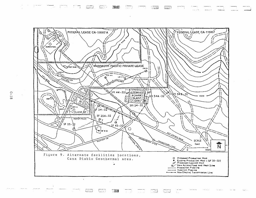
...-.-....
..".:,.\
o Pr~ ProducliQo"l W.H• EJllshl">Q ProductIon WfJll (SF 3~-32)
0'" ProDO~ rnJecl,on Wflllo...-~" Now kellS.' Road ;ar\'d ",,",II SlI..
___ PrOdOCllQl"l P;~IIr>4
.... .. In/&C!,on P'()(!I .......
• ---- Nfl. Elect"c Tran,mluk::rl Unot
\1 - II
~~ll\1 '\!l II~'- '\.0-.:::::::---11....... "'--:: -.::;, --,~
'~ ~,.~---"8t\'-.::::::::~ ~ ~~ ~~ "S:;:; "s l\ ~ ----"\'_ "''''' ":'s ", ~"S~~ SCALE '\(\1 ffi-""':::
1-. ~". )" I ... , \\ ...~ s ///1 ,.\ N
o sao
.,...\;:;~~1:~
•
FiGure 9. Alterllate facilities locations,Casa Diablo Geothermal area.
'.
.1
()
r~
00
11I I
I I
of SOme of these proposed projects, because of their nature,
size, and/or geograptlic location, are potentially much greater
than those to be anticipated from Cas a Diablo. Others may be more
benign. A comprehensive study of the cumulative impact of
potential development, however desirable from a resource
management perspective, is Ilot possible within the time
constraints of tllis project.
The present investigation and discussion indicate that the
Casa Diablo Geothermal Project, considered by itself, will likely
not have a significant impact upon the spring migration. In the
worst and unlikely case that deer avoid the project entirely,
there are at present alternate routes available to allow
migrating deer to reach their summer ranges. Thus, the Cas a
Diablo Geothermal Project by itself will likely have minimal
negative impact.
.-
C-19
rl,I
r
LITERATURE CITED
California Department of Fish and Game. 1984. Buttermilk Deer
Herd Management Plan. Prep. by Tom Blankinship, Bishop CA.
56pp.
1985a. Management Plan for the Casa Diablo Deer Herd.
Prep. by Ronald D. Thomas, DFG, Bishop CA. 53pp.
1985b. Management Plan for the Sherwin Grade Deer herd.
Prep. by Ronald D. Thomas, DFG, Bishop CA. 53pp.
.'
C-20
I