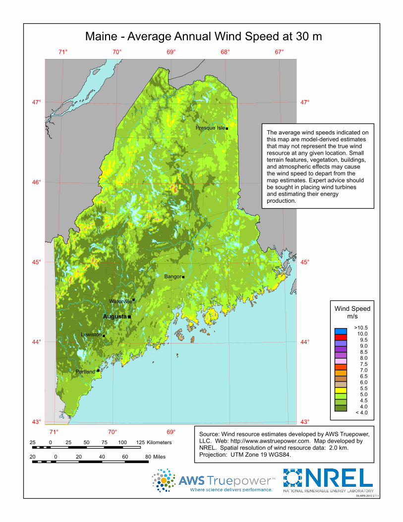
maine - average annual wind speed at 30 m · 67° 67° 68° 68° 69° 69° 70° 70° 71° 71° 47°...

1
" " " " " " 67° 68° 69° 69° 70° 70° 71° 71° 47° 47° 46° 45° 45° 44° 44° 43° 43° Maine - Average Annual Wind Speed at 30 m Augusta Bangor Presque Isle Waterville 04-APR-2012 2.1.1 Wind Speed m/s >10.5 10.0 9.5 9.0 8.5 8.0 7.5 7.0 6.5 6.0 5.5 5.0 4.5 4.0 < 4.0 Portland 20 0 20 40 60 80 Miles 25 0 25 50 75 100 125 Kilometers Lewiston Source: Wind resource estimates developed by AWS Truepower, LLC. Web: http://www.awstruepower.com. Map developed by NREL. Spatial resolution of wind resource data: 2.0 km. Projection: UTM Zone 19 WGS84. The average wind speeds indicated on this map are model-derived estimates that may not represent the true wind resource at any given location. Small terrain features, vegetation, buildings, and atmospheric effects may cause the wind speed to depart from the map estimates. Expert advice should be sought in placing wind turbines and estimating their energy production.

Upload: doankhanh

Post on 27-Aug-2018

220 views

Category:

Documents


0 download

TRANSCRIPT

"

"

"

"

"

"

67°

67°

68°

68°

69°

69°

70°

70°

71°

71°

47° 47°

46° 46°

45° 45°

44° 44°

43° 43°

Maine - Average Annual Wind Speed at 30 m

Augusta

Bangor

Presque Isle

Waterville

04-APR-2012 2.1.1

Wind Speedm/s

>10.5 10.0 9.5 9.0 8.5 8.0 7.5 7.0 6.5 6.0 5.5 5.0 4.5 4.0 < 4.0

Portland

20 0 20 40 60 80 Miles

25 0 25 50 75 100 125 Kilometers

Lewiston

Source: Wind resource estimates developed by AWS Truepower,LLC. Web: http://www.awstruepower.com. Map developed byNREL. Spatial resolution of wind resource data: 2.0 km.Projection: UTM Zone 19 WGS84.

The average wind speeds indicated onthis map are model-derived estimatesthat may not represent the true windresource at any given location. Smallterrain features, vegetation, buildings,and atmospheric effects may causethe wind speed to depart from themap estimates. Expert advice shouldbe sought in placing wind turbinesand estimating their energyproduction.