lidar r s p c cu-b lecture 37. laser...
TRANSCRIPT
LIDAR REMOTE SENSING PROF. XINZHAO CHU CU-BOULDER, SPRING 2016
Lecture 37. Laser Rangefinder q Introduction
Ø Different applications facing different challengesØ Various names: rangefinder, altimeter, ladar, bathymetry, etc.
q Rangefinding Techniques and PrinciplesØ Time of FlightØ Geometry-basedØ Interferometry / Diffraction ranging
q Time of Flight TechniquesØ Pulsed laser rangefindingØ CW laser amplitude modulationØ CW laser chirp / Chirp pulse compression
1
LIDAR REMOTE SENSING PROF. XINZHAO CHU CU-BOULDER, SPRING 2016
Introduction q Lidar remote sensing has two major functions: Ø One is to measure atmospheric or environmental species, density, temperature, wind, and waves along with their range distributions. Ø Another major function is to determine range - laser range finder. Laser altimeter is a special laser range finder.q A good reference for laser rangefinding techniques is a paper collection book -- “Selected Papers on Laser Distance Measurements”, edited by Brian J. Thompson, SPIE Milestone Series, 1995. Our textbook Chapter 8 “Airborne Lidar Systems” and Chapter 9 “Space-based Lidar” provide references for airborne and spaceborne laser altimeters. Other references could be found through web of science or SPIE related to the new laser altimeter projects.q Laser rangefinders can have various names, like laser altimeter, ladar (scanning laser radar for ranging), bathymetry, etc., depending on their applications. Laser rangefinding faces different challenges for different applications, so demanding different techniques.
2
LIDAR REMOTE SENSING PROF. XINZHAO CHU CU-BOULDER, SPRING 2016
Challenges vs. Applications q Laser altimeter: How accurately and precisely can you determine the absolute altitude? How to count in various interference factors, like multiple-scattering-induced time delay, platform absolute altitude uncertainties, etc.? How to improve range resolution / precision?q Long-distance rangefinder and lidar bathymetry: How far can your laser beam penetrate through? Light and EM waves usually experience server attenuation in water. How sensitive can your lidar detect far objects like satellites in the space (hundreds, thousands or more kilometers)?q Laser altimeter and bathymetry: How to achieve high resolution like cm or mm for climate monitoring? How to resolve shallow water depth?q Laser rangefinding: How to resolve tiny motion or range change to μm or smaller?q Ladar: How to achieve 3-D vision quickly and reliably?q ……
3
LIDAR REMOTE SENSING PROF. XINZHAO CHU CU-BOULDER, SPRING 2016
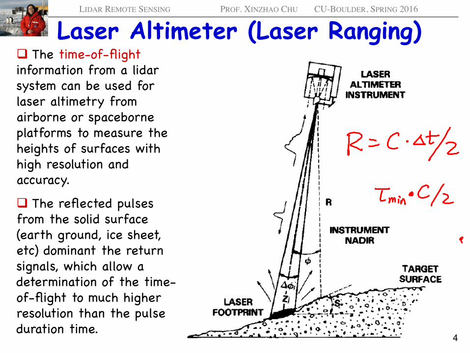
Laser Altimeter (Laser Ranging) q The time-of-flight information from a lidar system can be used for laser altimetry from airborne or spaceborne platforms to measure the heights of surfaces with high resolution and accuracy.
q The reflected pulses from the solid surface (earth ground, ice sheet, etc) dominant the return signals, which allow a determination of the time-of-flight to much higher resolution than the pulse duration time.
4
LIDAR REMOTE SENSING PROF. XINZHAO CHU CU-BOULDER, SPRING 2016
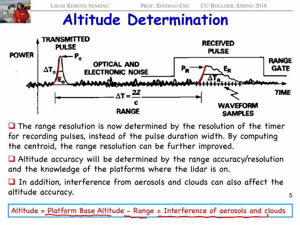
Altitude Determination
q The range resolution is now determined by the resolution of the timer for recording pulses, instead of the pulse duration width. By computing the centroid, the range resolution can be further improved.q Altitude accuracy will be determined by the range accuracy/resolution and the knowledge of the platforms where the lidar is on. q In addition, interference from aerosols and clouds can also affect the altitude accuracy.
Altitude = Platform Base Altitude - Range ± Interference of aerosols and clouds
5
LIDAR REMOTE SENSING PROF. XINZHAO CHU CU-BOULDER, SPRING 2016
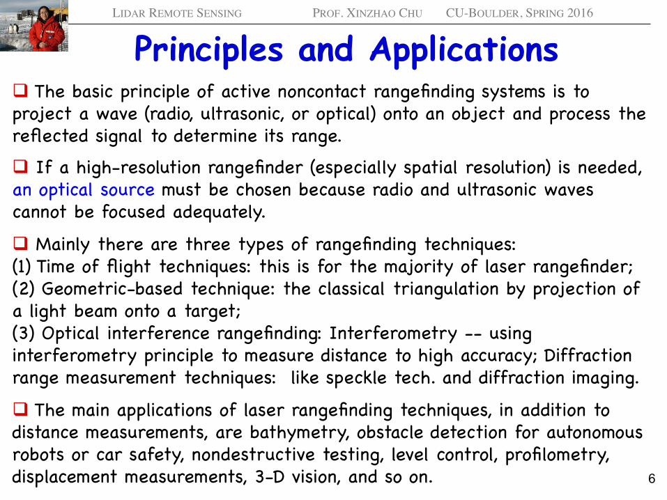
Principles and Applications q The basic principle of active noncontact rangefinding systems is to project a wave (radio, ultrasonic, or optical) onto an object and process the reflected signal to determine its range. q If a high-resolution rangefinder (especially spatial resolution) is needed, an optical source must be chosen because radio and ultrasonic waves cannot be focused adequately.
q Mainly there are three types of rangefinding techniques: (1) Time of flight techniques: this is for the majority of laser rangefinder; (2) Geometric-based technique: the classical triangulation by projection of a light beam onto a target; (3) Optical interference rangefinding: Interferometry -- using interferometry principle to measure distance to high accuracy; Diffraction range measurement techniques: like speckle tech. and diffraction imaging.
q The main applications of laser rangefinding techniques, in addition to distance measurements, are bathymetry, obstacle detection for autonomous robots or car safety, nondestructive testing, level control, profilometry, displacement measurements, 3-D vision, and so on. 6
LIDAR REMOTE SENSING PROF. XINZHAO CHU CU-BOULDER, SPRING 2016
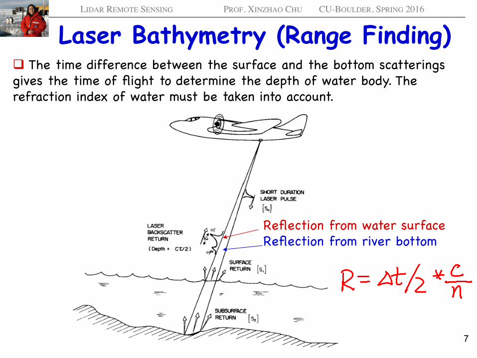
Laser Bathymetry (Range Finding) q The time difference between the surface and the bottom scatterings gives the time of flight to determine the depth of water body. The refraction index of water must be taken into account.
Reflection from water surfaceReflection from river bottom
7
LIDAR REMOTE SENSING PROF. XINZHAO CHU CU-BOULDER, SPRING 2016
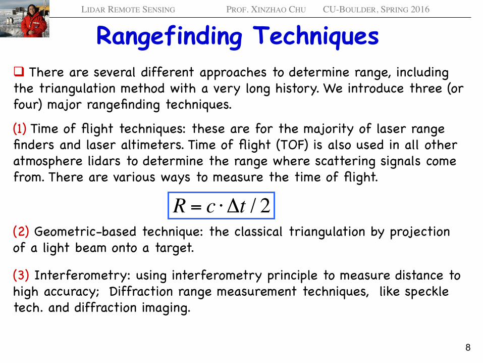
Rangefinding Techniques q There are several different approaches to determine range, including the triangulation method with a very long history. We introduce three (or four) major rangefinding techniques.
(1) Time of flight techniques: these are for the majority of laser range finders and laser altimeters. Time of flight (TOF) is also used in all other atmosphere lidars to determine the range where scattering signals come from. There are various ways to measure the time of flight.
(2) Geometric-based technique: the classical triangulation by projection of a light beam onto a target.
(3) Interferometry: using interferometry principle to measure distance to high accuracy; Diffraction range measurement techniques, like speckle tech. and diffraction imaging.
R = c ⋅ Δt / 2
8
LIDAR REMOTE SENSING PROF. XINZHAO CHU CU-BOULDER, SPRING 2016
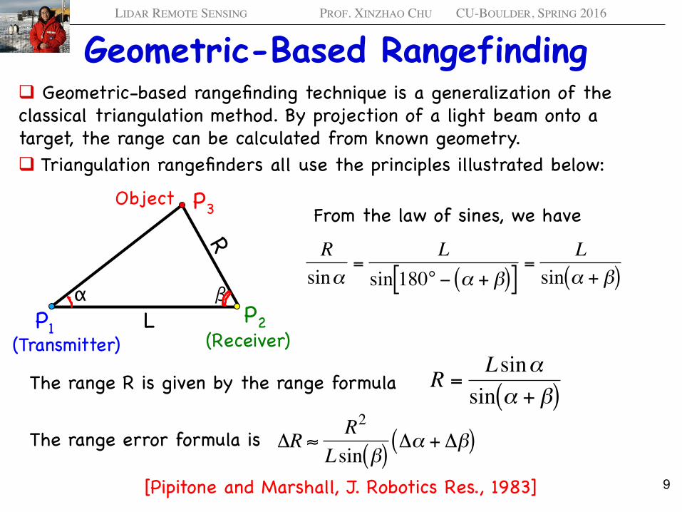
Geometric-Based Rangefinding q Geometric-based rangefinding technique is a generalization of the classical triangulation method. By projection of a light beam onto a target, the range can be calculated from known geometry. q Triangulation rangefinders all use the principles illustrated below:
P1P2
P3Object
α βL
From the law of sines, we have
€
Rsinα
=L
sin 180° − α + β( )[ ]=
Lsin α + β( )
The range R is given by the range formula
€
R =Lsinαsin α + β( )
The range error formula is
€
ΔR ≈ R2
Lsin β( )Δα + Δβ( )
[Pipitone and Marshall, J. Robotics Res., 1983]
(Transmitter) (Receiver)
9
LIDAR REMOTE SENSING PROF. XINZHAO CHU CU-BOULDER, SPRING 2016
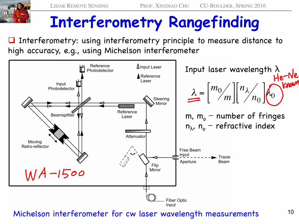
Interferometry Rangefinding q Interferometry: using interferometry principle to measure distance to high accuracy, e.g., using Michelson interferometer
WA-1000 & WA-1500 Operating Manual 2. Theory of Operation
Burleigh Instruments, Inc. (06737-M-00 Rev H) 2-1
2. Theory of Operation
This chapter reviews the theory behind wavelength measurement as it applies to theWA-1500 and WA-1000. It also discusses the factors that influence the accuracy of themeasurement.
Operating Principles
Reference Photodetector
Input Photodetector
Reference Laser
Input Laser
Reference LaserBeamsplitter
Fiber OpticInput
Flip Mirror
Moving Retro-reflector
Attenuator
Steering Mirror
Free BeamInput Tracer
BeamAperture
Figure 2.1. Optical schematic.
A variety of techniques have been devised to determine the wavelength of lasers.Interferometric techniques have proven to be the most practical, precise and reliable forwavelength measurement instrumentation.
The WA-1500 and WA-1000 use a Michelson interferometer to generate sinusoidalinterference fringes from the input radiation. The optical layout is shown schematicallyin Figure 2.1.
Michelson interferometer for cw laser wavelength measurements
Input laser wavelength λ
m, mo − number of fringesnλ, no − refractive index
€
λ = m0m
# $ %
& ' ( nλ
n0# $ %
& ' ( λ0
10
LIDAR REMOTE SENSING PROF. XINZHAO CHU CU-BOULDER, SPRING 2016
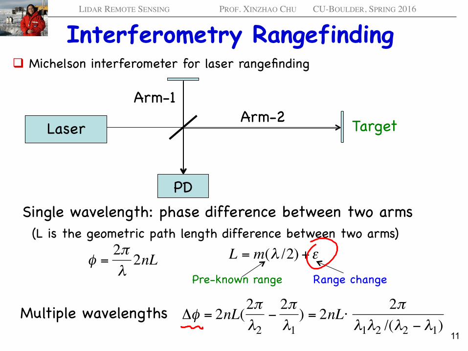
Interferometry Rangefinding q Michelson interferometer for laser rangefinding
Laser
Arm-1Arm-2
PDSingle wavelength: phase difference between two arms
€
φ =2πλ2nL
€
L = m(λ /2) +ε
€
Δφ = 2nL(2πλ2
−2πλ1) = 2nL⋅ 2π
λ1λ2 /(λ2 − λ1)Multiple wavelengths
Target
Pre-known range Range change
(L is the geometric path length difference between two arms)
11
LIDAR REMOTE SENSING PROF. XINZHAO CHU CU-BOULDER, SPRING 2016
Interferometry Rangefinding q Both interferometry and diffraction techniques utilize the multiple beam interference principles to generate interference fringes or diffraction patterns. By counting the phase difference caused by path difference, small range or range change can be determined to very precise degree. However, if only single wavelength is used, range ambiguity will occur beyond half of the laser wavelength (λ/2) range.q To increase the range of detection or say to remove the range ambiguity, multiple wavelengths are used to generate various longer wavelength, called synthetic wavelength. For example, using two wavelengths λ1 and λ2, the synthetic wavelength is given by
q By adjusting λ1 and λ2 values, the synthetic wavelength λ can be much larger than the original two wavelengths. Thus, the range to be determined without ambiguity can be enlarged to λ/2.
€
λ =λ1λ2
(λ2 − λ1)
12
LIDAR REMOTE SENSING PROF. XINZHAO CHU CU-BOULDER, SPRING 2016
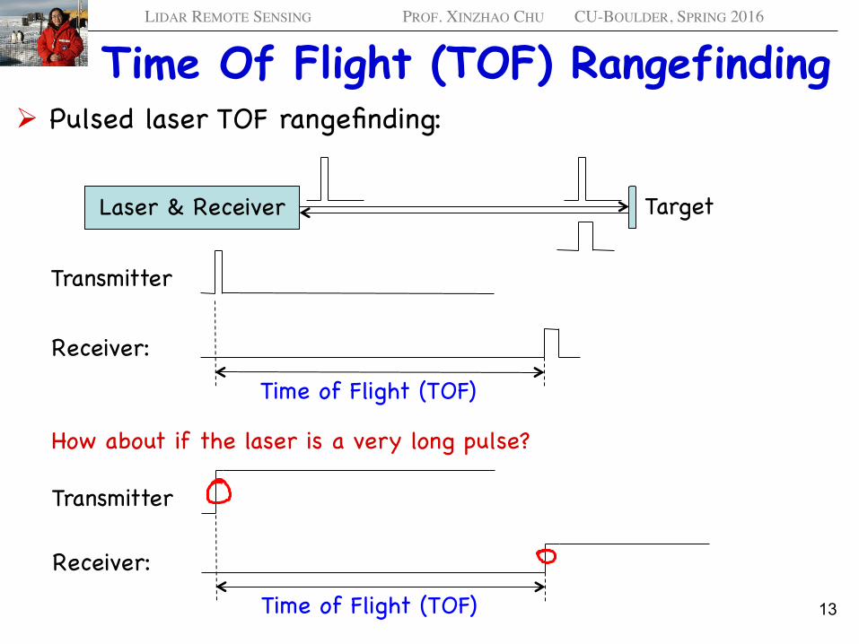
Time Of Flight (TOF) Rangefinding Ø Pulsed laser TOF rangefinding:
Laser & Receiver Target
Transmitter
Receiver:
Time of Flight (TOF)
Receiver:
Time of Flight (TOF)
Transmitter
How about if the laser is a very long pulse?
13
LIDAR REMOTE SENSING PROF. XINZHAO CHU CU-BOULDER, SPRING 2016
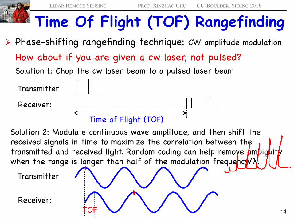
Time Of Flight (TOF) Rangefinding Ø Phase-shifting rangefinding technique: CW amplitude modulation
How about if you are given a cw laser, not pulsed?
Transmitter
Receiver:
Time of Flight (TOF)
Solution 1: Chop the cw laser beam to a pulsed laser beam
Receiver:
Transmitter
Solution 2: Modulate continuous wave amplitude, and then shift the received signals in time to maximize the correlation between the transmitted and received light. Random coding can help remove ambiguity when the range is longer than half of the modulation frequency/λ.
0 5 10 15 20−2
−1.5
−1
−0.5
0
0.5
1
1.5
2
0 5 10 15 20−2
−1.5
−1
−0.5
0
0.5
1
1.5
2
TOF 14
LIDAR REMOTE SENSING PROF. XINZHAO CHU CU-BOULDER, SPRING 2016
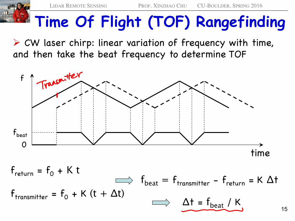
Time Of Flight (TOF) Rangefinding Ø CW laser chirp: linear variation of frequency with time, and then take the beat frequency to determine TOF
0fbeat
f
time
freturn = f0 + K t
ftransmitter = f0 + K (t + Δt)fbeat = ftransmitter - freturn = K Δt
Δt = fbeat / K 15
LIDAR REMOTE SENSING PROF. XINZHAO CHU CU-BOULDER, SPRING 2016
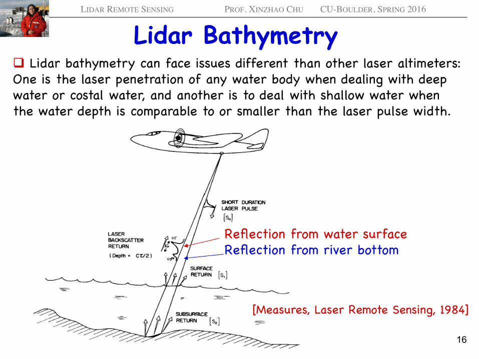
Lidar Bathymetry q Lidar bathymetry can face issues different than other laser altimeters: One is the laser penetration of any water body when dealing with deep water or costal water, and another is to deal with shallow water when the water depth is comparable to or smaller than the laser pulse width.
Reflection from water surfaceReflection from river bottom
[Measures, Laser Remote Sensing, 1984]
16
LIDAR REMOTE SENSING PROF. XINZHAO CHU CU-BOULDER, SPRING 2016
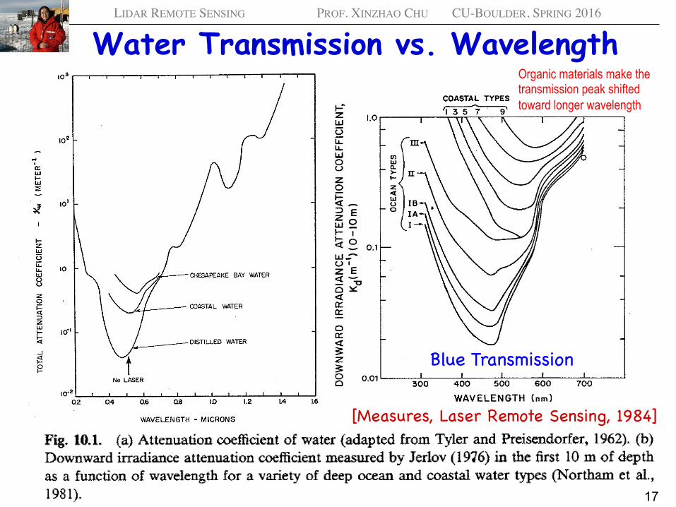
Water Transmission vs. Wavelength
[Measures, Laser Remote Sensing, 1984]
Blue Transmission
Organic materials make the transmission peak shifted toward longer wavelength
17
LIDAR REMOTE SENSING PROF. XINZHAO CHU CU-BOULDER, SPRING 2016
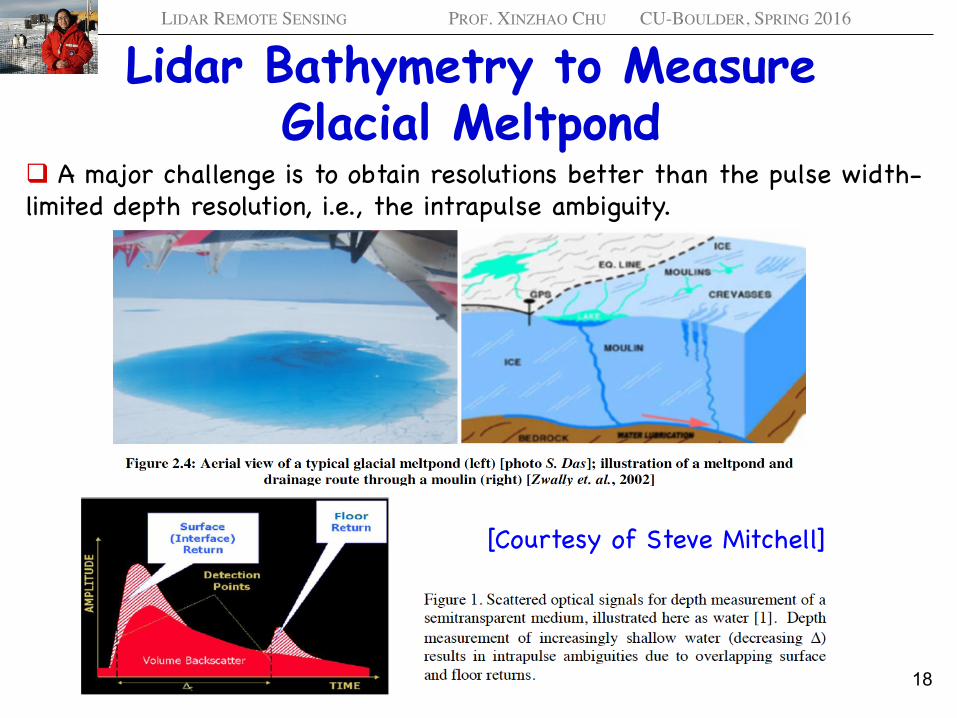
Lidar Bathymetry to Measure Glacial Meltpond
q A major challenge is to obtain resolutions better than the pulse width-limited depth resolution, i.e., the intrapulse ambiguity.
[Courtesy of Steve Mitchell]
18
LIDAR REMOTE SENSING PROF. XINZHAO CHU CU-BOULDER, SPRING 2016
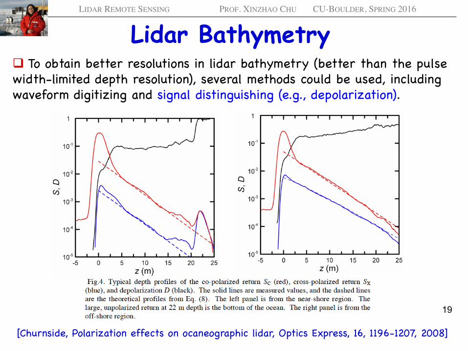
Lidar Bathymetry q To obtain better resolutions in lidar bathymetry (better than the pulse width-limited depth resolution), several methods could be used, including waveform digitizing and signal distinguishing (e.g., depolarization).
[Churnside, Polarization effects on ocaneographic lidar, Optics Express, 16, 1196-1207, 2008]
19
LIDAR REMOTE SENSING PROF. XINZHAO CHU CU-BOULDER, SPRING 2016
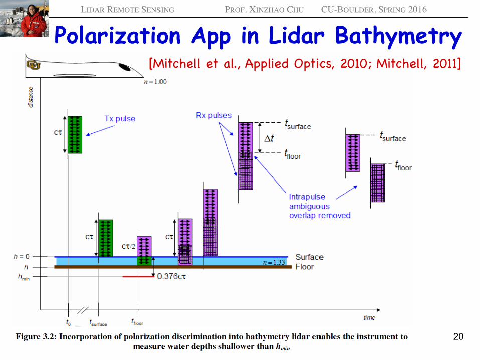
Polarization App in Lidar Bathymetry [Mitchell et al., Applied Optics, 2010; Mitchell, 2011]
20
LIDAR REMOTE SENSING PROF. XINZHAO CHU CU-BOULDER, SPRING 2016
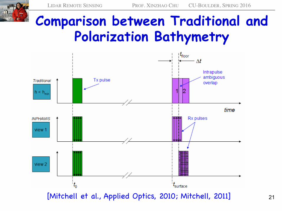
Comparison between Traditional and Polarization Bathymetry
[Mitchell et al., Applied Optics, 2010; Mitchell, 2011] 21
LIDAR REMOTE SENSING PROF. XINZHAO CHU CU-BOULDER, SPRING 2016
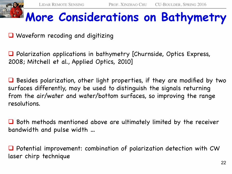
More Considerations on Bathymetry q Waveform recoding and digitizing
q Polarization applications in bathymetry [Churnside, Optics Express,2008; Mitchell et al., Applied Optics, 2010]
q Besides polarization, other light properties, if they are modified by two surfaces differently, may be used to distinguish the signals returning from the air/water and water/bottom surfaces, so improving the range resolutions.
q Both methods mentioned above are ultimately limited by the receiver bandwidth and pulse width …
q Potential improvement: combination of polarization detection with CW laser chirp technique
22
LIDAR REMOTE SENSING PROF. XINZHAO CHU CU-BOULDER, SPRING 2016
Summary q Laser rangefinding is an important lidar category, and it finds many fantastic applications in science research, environment monitoring, industry, daily life. It has various names like laser rangefinder, laser altimeter, lidar bathymetry, ladar, etc., depending on actual applications.
q Different rangefinding applications have different challenges, e.g., tiny motion/range change vs. absolute altitude determination, long-path penetration vs. shallow-water discrimination, etc.
q Geometric-based triangulation laser rangefinding, optical interference rangefinding (interferometer vs. diffraction), and time of flight (TOF) are the three major categories of laser rangefinding.
q There are various TOF techniques, in addition to a traditional single-channel pulsed-laser-based lidar TOF. Multiple channels with distinctly different features (e.g., polarization) can be used to determine TOF with resolutions higher than the pulse width. CW laser amplitude modulation, CW laser frequency chirp, etc. all can be used to determine fine and long range (TOF). Keep an open mind to more possibilities.
23
LIDAR REMOTE SENSING PROF. XINZHAO CHU CU-BOULDER, SPRING 2016
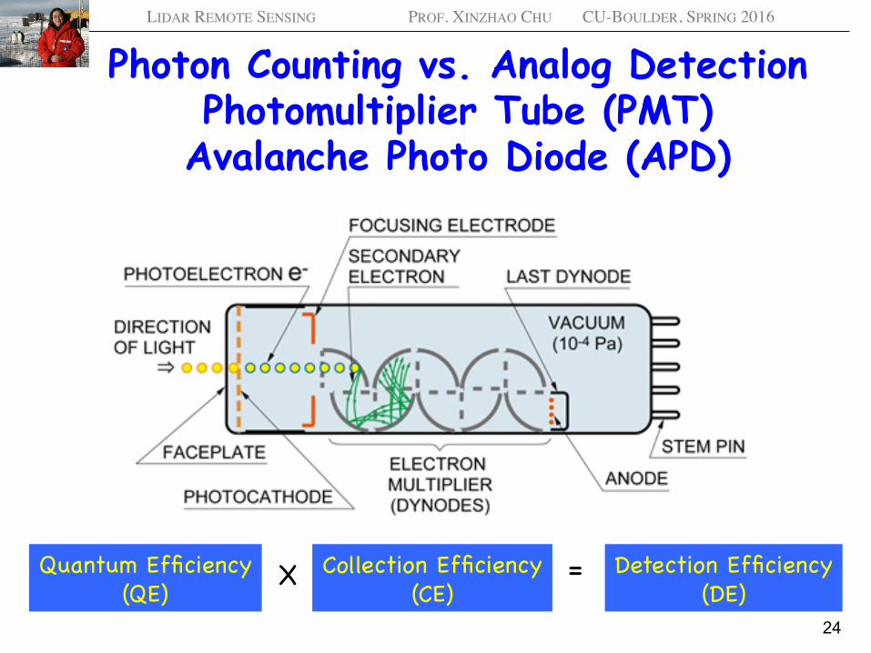
Photon Counting vs. Analog Detection Photomultiplier Tube (PMT)
Avalanche Photo Diode (APD)
24
Detection Efficiency(DE)
Collection Efficiency(CE)
Quantum Efficiency(QE)
X =
LIDAR REMOTE SENSING PROF. XINZHAO CHU CU-BOULDER, SPRING 2016
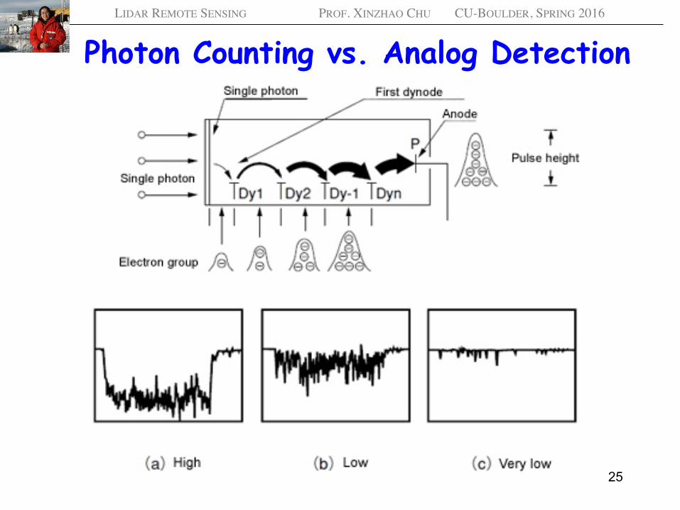
Photon Counting vs. Analog Detection
25
LIDAR REMOTE SENSING PROF. XINZHAO CHU CU-BOULDER, SPRING 2016
Photon Counting vs. Analog Detection
26
Photon counting is suitable for very-low-level light detection, ideally in the single photoelectron region.
Analog detection is suitable for high-level light detection.
The goals are to maximize the signal to noise ratio (SNR) and achieve the most sensitive detection of light.