lets walk newport - healthy start walks
TRANSCRIPT
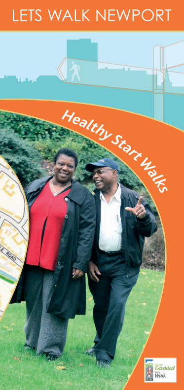
LETS WALK NEWPORT
Healthy Start Walks
LetsWalkNewport - Healthy StartWalks
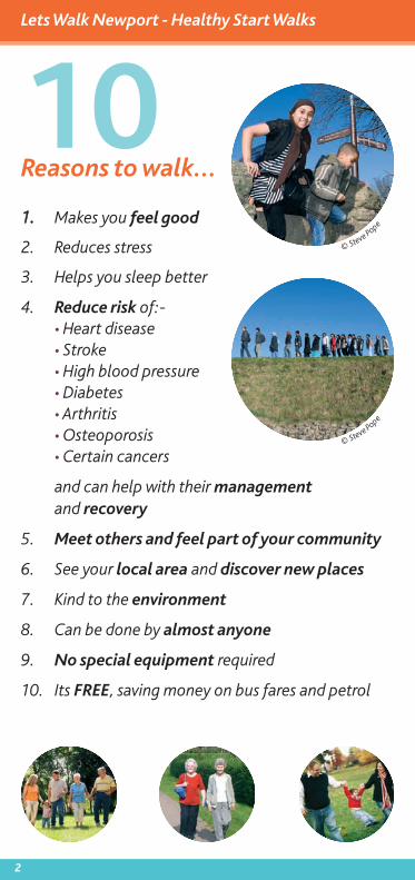
10Reasons towalk...
11.. Makes you feel good
2. Reduces stress
3. Helps you sleep better
4. Reduce risk of:-• Heart disease• Stroke• High blood pressure• Diabetes• Arthritis• Osteoporosis• Certain cancers
and can help with their managementand recovery
5. Meet others and feel part of your community
6. See your local area and discover new places
7. Kind to the environment
8. Can be done by almost anyone
9. No special equipment required
10. Its FREE, saving money on bus fares and petrol
© Steve
Pope
© Steve
Pope
2
Lets Walk Newport - Healthy Start Walks
3
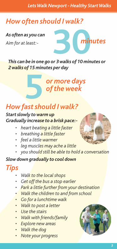
How often should I walk?
As often as you can
Aim for at least:-
This can be in one go or 3 walks of 10 minutes or2 walks of 15 minutes per day
305
minutes
or more daysof the week
How fast should I walk?Start slowly to warm upGradually increase to a brisk pace:-
• heart beating a little faster• breathing a little faster• feel a little warmer• leg muscles may ache a little• you should still be able to hold a conversation
Slow down gradually to cool down
Tips• Walk to the local shops• Get off the bus a stop earlier• Park a little further from your destination• Walk the children to and from school• Go for a lunchtime walk• Walk to post a letter• Use the stairs• Walk with friends/family• Explore new areas• Walk the dog• Note your progress
Lets Walk Newport - Healthy Start Walks
4
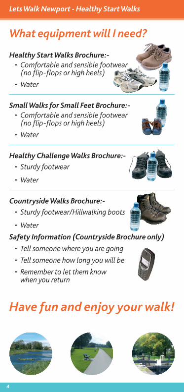
What equipment will I need?
Healthy Start Walks Brochure:-• Comfortable and sensible footwear
(no flip-flops or high heels)
• Water
Small Walks for Small Feet Brochure:-• Comfortable and sensible footwear
(no flip-flops or high heels)
• Water
Healthy Challenge Walks Brochure:-
• Sturdy footwear
• Water
Countryside Walks Brochure:-
• Sturdy footwear/Hillwalking boots
• Water
Safety Information (Countryside Brochure only)
• Tell someone where you are going
• Tell someone how long you will be
• Remember to let them knowwhen you return
Have fun and enjoy your walk!
Lets Walk Newport - Healthy Start Walks
5
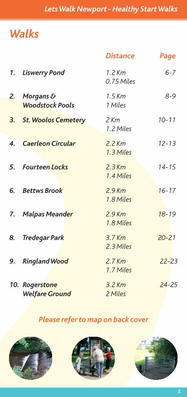
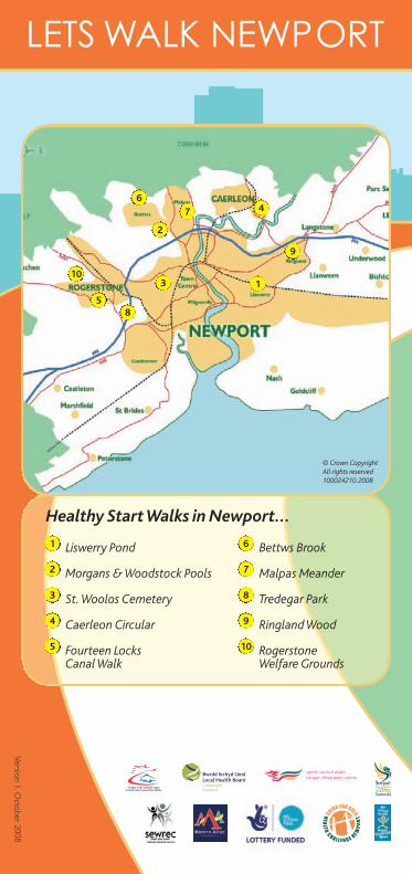
Walks
Distance Page
1. Liswerry Pond 1.2 Km 6-70.75 Miles
2. Morgans & 1.5 Km 8-9Woodstock Pools 1 Miles
3. St. Woolos Cemetery 2 Km 10-111.2 Miles
4. Caerleon Circular 2.2 Km 12-131.3 Miles
5. Fourteen Locks 2.3 Km 14-151.4 Miles
6. Bettws Brook 2.9 Km 16-171.8 Miles
7. Malpas Meander 2.9 Km 18-191.8 Miles
8. Tredegar Park 3.7 Km 20-212.3 Miles
9. Ringland Wood 2.7 Km 22-231.7 Miles
10. Rogerstone 3.2 Km 24-25Welfare Ground 2 Miles
Please refer to map on back cover
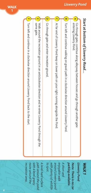
Liswerry PondWWAALLKK11
WWAALLKK
11
Liswerry Pond
Note: There is no car
parking available.
A short and
enjoyable walk
around Liswerry pond
with plenty of w
ildlifeto spot.
A level hard surface
path around the pondw
ith a level grassyroute around therecreation area.
Start at bottom of Lisw
erry Road...
6
Go through gate, continue along alleyw
ay between houses and go through another gate
entering Liswerry Pond.
Turn left and continue walking on gravel path in a clockw
ise direction around Liswerry Pond.
At far end of Liswerry Pond keep on low
er path on your right running alongside the Pond.
Go through gate and enter recreation ground.
Walk around the recreation ground in an anticlockw
ise direction and re-enter Liswerry Pond through the
same gate.
Turn left and continue in a clockwise direction around Lisw
erry Pond back to the start.
ABCDEF
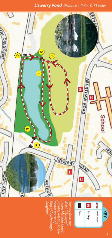
Liswerry Pond Distance 1.2 Km, 0.75 Miles
7
KEY
Walk Ro
ute
Bus Stop
Gate
Liswerry from
theW
elsh “Llyswyry”
means M
aidens Court,
possibly relating to them
anor house ofKing of Brycheiniog’sdaughter.
A
B
C
D
E
F
B
B
B
B
B
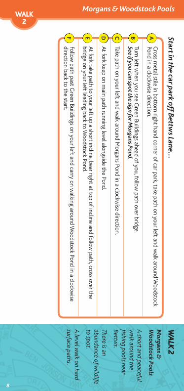
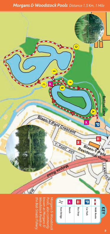
Morgans & Woodstock PoolsWWAALLKK22
Start in the car park off B
ettws Lane...
8
Cross m
etal stile in bottom right hand corner of car park, take path on your left and w
alk around Woodstock
Pond in a clockwise direction.
Turn left when you see G
reen Buildings ahead of you, follow path over bridge.
See if you can spot the sign for Morgans Pond.
Take path on your left and walk around M
organs Pond in a clockwise direction.
At fork keep on main path running level alongside the Pond.
At fork take path to your left up a short incline, bear right at top of incline and follow path, cross over the
bridge on your left leading back to Woodstock Pond.
Follow path past G
reen Buildings on your left and carry on walking around W
oodstock Pond in a clockwise
direction back to the start.
ABCDEF
WWAALLKK
22
Morgans &
Woodstock Pools
A short and peaceful
walk around the
fishing pools nearBettw
s.
There is anabundance of w
ildlifeto spot.
A level w
alk on hardsurface paths.
9
Morgans & Woodstock Pools Distance 1.5 Km, 1 MileKEY
Walk Ro
ute
Car Park
Bus Stop
Bench
Foot Bridge
P
P
B
B
B
Y
Y
Y
Morgans &
Woodstock
Pools, also comm
onlyknow
n as Morgans &
Woodstock Ponds or
the Bob Smalls Fishery.
A
B
FC
E
D
Bettws Lane
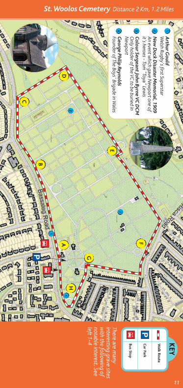
St. Woolos CemeteryWWAALLKK33
Start at main entrance to St W
oolos Cem
etery on Bassaleg Road...
10
Turn left before cemetery office and follow
tarmac footpath around outer edge of cem
etery down a slight
slope (fine views of hills ahead)
Bear left and carry on along main road around cem
etery in a clockwise direction.
Keep following m
ain road around cemetery dow
n a slope then uphill.There are m
any options to take the footpaths on your left around the outer edge of cemetery w
hich loopback to the m
ain road around the cemetery.
Turn right and keep following m
ain road around cemetery leading uphill.
When reach a building ahead of you take the sm
all footpath on your right, between bollards then turn left
and follow footpath around outer edge of cem
etery.Option to carry on past the building ahead of you, through kissing gate into sm
all wood outside cem
eteryboundary leading to R
isca Road, turn right on pavement along R
isca Road and back into cemetery
entrance at point F.
Keep straight ahead on footpath passing a gate entrance on your left and follow footpath around outer edge
of cemetery.
At path junction turn left and follow road around cem
etery in a clockwise direction.
At mini roundabout keep follow
ing outer path round edge of cemetery back to start.
ABCDEFGH
WWAALLKK
33St. W
oolosCem
etery
A lovely w
alk with
fine views of the
hillsides surroundingN
ewport.
Some tarm
acfootpaths are uneven,otherw
ise use main
road aroundcem
etery.
There are many
benches to rest at.
KEY
Walk Ro
ute
Car Park
Bus Stop
P
P
B
11
There are many
interesting grave sitesw
ith the following of
notable interest. Seeleft 1-4
Arthur G
ouldW
elsh Rugby's first Superstar
New
Dock D
isaster Mem
orial, 1909An event w
hich gave New
port one ofit's heroes - Tom
"Toya" Lewis
Colour Sergeant John B
yrne VC DCM
Only holder of the VC
to be buried inN
ewport
George Philip Reynolds
Founder of The Boys' Brigade in Wales
1234
A
B
C
D
E
F
G
H
1
2
3
4
BB
St. Woolos Cemetery Distance 2 Km, 1.2 Miles
Caerleon CircularWWAALLKK44
Start in car park on B
roadway Road...
12
Go through the gate leading to the A
mphitheatre, w
alkaround A
mphitheatre in a clockw
ise direction keepingon the level grass and exit using the sam
e gate.
Cross over the roundabout using the trafficisland and continue dow
n Usk Road.
Turn right along Broadway Road then take the tarm
acpath know
n as Fosse Lane on your left leading towards
the Barracks. Option to take short path leading to
Barracks and return by same route to tarm
ac path.
Cross over U
sk Road into Afon Lwyd C
lose,bear right betw
een houses onto Tram Road.
At end of Fosse Lane turn right onto Cold Bath Road,take the gate on your left and w
alk around the grassyperim
eter of Caerleon A
FC Football G
round.
Turn left at junction with M
ill Street thencross road and head up Backhall Street. Take care as M
ill Street is a busy road to cross.
Exit gate and turn right along road towards junction
with Cold Bath Road, turn left and continue along Cold
Bath Road.
At fork take road on your left and continuestraight ahead onto M
useum Street.
Turn right at junction with Lodge Road then turn left,
crossing road by The Drovers A
rms and follow
road nextto G
oldcroft Common. Take care as there are no
pavements along this road.
At junction with the H
igh Street, cross overthe road tow
ards Broadway Road back to the
car park. Take care as the Hight Street is a
busy road to cross.
ABCDE
FGHIJ
WWAALLKK
44Caerleon C
ircular
A w
onderful historicalw
alk around Caerleon
and the remains
of the Roman
Am
phitheatre andBarracks.
A level w
alk, mostly
on pavements or hard
surface with grass
around theAm
phitheatre.
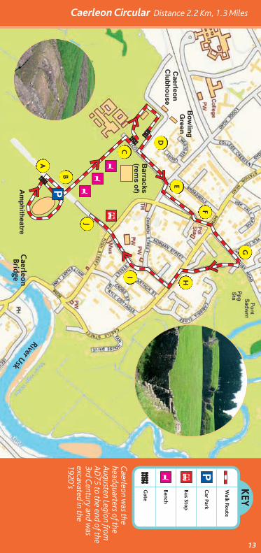
Caerleon Circular Distance 2.2 Km, 1.3 Miles
13
KEY
Walk Ro
ute
Car Park
Bus Stop
Bench
Gate
PBY
Caerleon w
as theheadquarters of theAugusten Legion from
AD
75 to the end of the3rd C
entury and was
excavated in the1920’s
A
B
C
D
E
F
G
HI
J
P Y
Y
YB
Caerleo
nBridge
River Usk
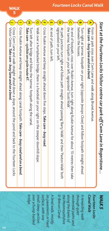
Fourteen Locks Canal WalkWWAALLKK55
WWAALLKK
55
Fourteen LocksCanal W
alk
A rew
arding walk
through quietresidential paths andalong the banks ofthe M
onmouthshire
& Brecon C
anal.
A level w
alk, mostly
on pavements or hard
surface, with one
small steep section
over a hump backed
bridge.
14
Start at the Fourteen Locks Visitor centre car p
ark off Cwm Lane in Rogerstone...
From car park cross over C
wm Lane and w
alk along Brunel Avenue.Take care - busy lane and on a bend.
Turn right at tarmac footpath on your right (opposite Jessops C
lose) and follow footpath straight ahead
between the houses.
At end of footpath, cross over Ruskin Avenue, turn right along Ruskin Avenue for about 10 metres then take
the tarmac footpath on your left, signposted ‘Scott W
alk’.
At path junction turn right and follow path straight ahead passing ‘Barry W
alk’ and then ‘Paxton Walk’ both
signposted on your left.
At end of path, turn left.
Cross Ruskin Avenue and keep straight ahead dow
n five steps. Take care - busy road.
Walk over a hum
pbacked bridge, there is a handrail on your right on the steeper downhill slope.
Turn left after bridge and follow the tarm
ac footpath along the canal.Take care - cyclists on cycle route 47.
Cross Ruskin Avenue and keep straight ahead along canal footpath. Take care - busy road and on a bend.
Cross C
wm Lane and w
alk straight ahead down a slope, around the pond and back to the Fourteen Locks
Visitor Centre. Take care - busy lane and on a bend.
ABCDEFGHIJ
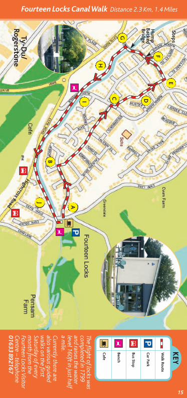
Fourteen Locks Canal Walk Distance 2.3 Km, 1.4 Miles
15
KEY
Walk Ro
ute
Car Park
Bus Stop
Bench
Cafe
PB!
The flight of locks was
completed in 1799
and raises the water
level 160ft in just halfa m
ile.Currently there are
also various guidedw
alks on the firstSaturday of everym
onth from the
Fourteen Locks VisitorCentre – telephone
01633 892167
A
B
C D
E
F
G
H
I
J
P
B
B
!
Y
Y
Y
Hump
BackedBridge
Steps
Ty-Du/
Rogerstone
Highcross Road
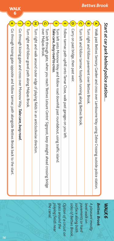
Bettws BrookWWAALLKK66
WWAALLKK
66
Bettw
s Brook
A pleasant m
ostlylevel w
alk onpavem
ents or hardsurface along bothsides of Bettw
s Brook.
Option of a circuit on
grass around theplaying fields nearthe canal.
Start at car park behind p
olice station...
Walk past Bettw
s Sensory Garden and cross over Lam
bourne Way using Zebra C
rossing outside police station.
Turn right and follow pavem
ent over Bettws Brook.
Turn left and follow tarm
ac footpath running along Bettws Brook.
Carry on past bridge, then past w
eir.
Follow tarm
ac path uphill onto Tamar C
lose, walk past garages on you left.
Turn left onto Monnow
Way and follow
road downhill past roundabout, using traffic island.
Take care, busy road to cross.
Turn left through gate, when you reach ‘Bettw
s Leisure Centre’ Signpost, keep straight ahead crossing bridgeover M
alpas Brook.
Turn right and walk around outer edge of playing fields in an anticlockw
ise direction.
Turn right and follow gravel path along M
alpas Brook.
Go through kissing gate and cross over M
onnow Way. Take care, busy road.
Go through kissing gate opposite and follow
tarmac path alongside Bettw
s Brook back to the start.
ABCDEFGHIJK
16
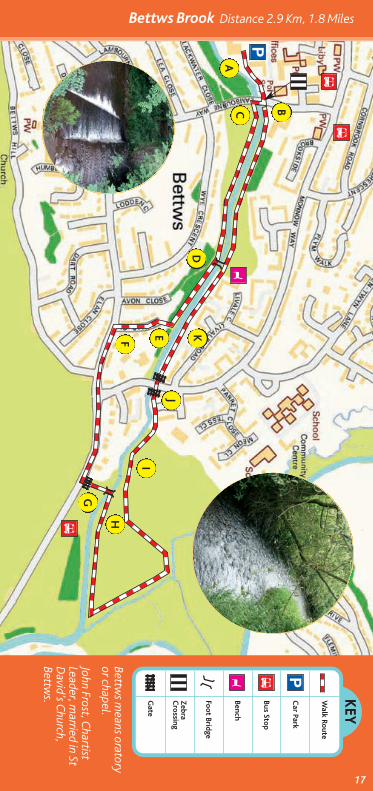
Bettws Brook Distance 2.9 Km, 1.8 Miles
17
KEY
Walk Ro
ute
Car Park
Bus Stop
Bench
Foot Bridge
ZebraCrossing
Gate
PBY
Bettws m
eans oratoryor chapel.
John Frost, Chartist
Leader, married in St
David’s C
hurch,Bettw
s.
P
BB
A
BC
D
EF
G
H
I
J
K
B
Y
Malpas MeanderWWAALLKK77
18
Start at the car park in G
rove Park off Pillmaw
r Road...WWAALLKK
77
Malp
as Meander
This satisfying walk
follows som
epleasant residentialpaths and along anenjoyable section ofthe cycle route. Thereare som
e delightfulw
ooden sculpturesand m
any benches torest at.
A level w
alk, mostly
on pavements or hard
surface, with a short
incline and declinenear the cycle route.
From car park w
alk up tarmac footpath past children’s
playground on your left and Gladiator Pub on your right.
At bottom of slope turn right and follow
pathpast benches and w
ood carvings.
Follow path through underpass, continue straight ahead.
Walk around short loop at end of path, then
head back towards benches and w
oodcarvings.
When you reach trees and grass in front, turn right,
then immediate left and follow
path over footbridge.Keep on path, past tw
o footbridges on yourright, head up slope on your left w
ith handrailjust before w
oodcarving.
Keep straight ahead and at end of grassy groundturn right.
At top of slope, keep straight ahead towards
“Clarem
ont” sign and follow path betw
eenhouses.
Follow path straight ahead, then turn right follow
ingpaved footpath around bend and continue straightahead.
At bollard bear left, then turn left at pathcrossroads, heading up slope tow
ardsfootbridge.
At end of path, turn right, then first left going downhill,
using handrail if necessary.Walk over footbridge keeping straight ahead
and then turn right at white bungalow
s(signed for houses “235-387”) and continueback to start, rem
embering to stay left at both
forks with bollards.
ABCDEF
GHIJKL
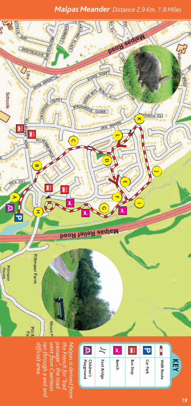
Malpas Meander Distance 2.9 Km, 1.8 Miles
19
KEY
Walk Ro
ute
Car Park
Bus Stop
Bench
Foot Bridge
Children’sPlaygro
und
PBY
Y
Y Y
Malpas is derived from
the French for “badpassage”, the roadw
est from C
aerleonran through a w
et anddifficult area.
A
B
C
D
I
J
K
L
E
F
G
H
P
B B
B
B
?
?

Tredegar ParkWWAALLKK88
WWAALLKK
88
Tredegar Park
A fine w
alk across theopen spaces of thepark and beyond intothe attractive oldgolfing range, skirtingthe river Ebbw
.
A level w
alk, mostly
on tarmac or hard
surface, with som
eshort steep unevensections near theriver.
20
Start in car park at Tredegar Park...
Walk along the tarm
ac track passing the LifeTrail exercise equipment,
have a go if you are feeling energetic!
At the end of the tarmac path w
alk through the M4 underpass.
Take the first left hand path and walk in a clockw
ise direction on the grassy path.
Follow path over a sm
all bridge over a brook and turn right. Follow path until it becom
es gravel.
Follow the gravel path then turn right w
here it forks. After 30 metres take the level path straight ahead,
not the path leading downhill on your right.
At bridge over Ebbw River do not cross. Keep straight ahead dow
n a narrow path running alongside the river.
Follow the path and w
hen it meets the m
ain path continue to the left, heading back towards the underpass
and walk back to the start.
ABCDEFG
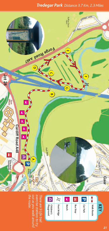
Tredegar Park Distance 3.7 Km, 2.3 Miles
21
KEY
Walk Ro
ute
Car Park
Bus Stop
Bench
Foot Bridge
Children’sPlaygro
und
PBY
There are 9 Life trailexercise stations to tryout as you w
alk aroundthe route.
?B
PA
BC
D
E
F
G
YY
YY
Y
?
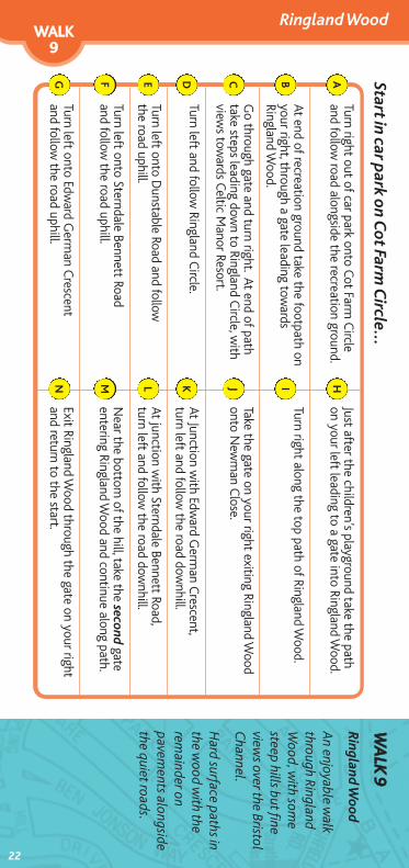
Ringland WoodWWAALLKK99
Start in car park on C
ot Farm Circle...
22
Turn right out of car park onto Cot Farm Circle
and follow road alongside the recreation ground.
Just after the children’s playground take the pathon your left leading to a gate into Ringland W
ood.
At end of recreation ground take the footpath onyour right, through a gate leading tow
ardsRingland W
ood.
Turn right along the top path of Ringland Wood.
Go through gate and turn right. At end of pathtake steps leading dow
n to Ringland Circle, w
ithview
s towards Celtic M
anor Resort.
Take the gate on your right exiting Ringland Wood
onto Newman C
lose.
Turn left and follow Ringland C
ircle.At Junction w
ith Edward G
erman C
rescent,turn left and follow
the road downhill.
Turn left onto Dunstable Road and follow
the road uphill. At junction w
ith Sterndale Bennett Road,turn left and follow
the road downhill.
Turn left onto Sterndale Bennett Roadand follow
the road uphill.Near the bottom
of the hill, take the secondgate
entering Ringland Wood and continue along path.
Turn left onto Edward G
erman C
rescentand follow
the road uphill.Exit Ringland W
ood through the gate on your rightand return to the start.
ABCDEFG
HIJKLMN
WWAALLKK
99
Ringland W
ood
An enjoyable w
alkthrough RinglandW
ood, with som
esteep hills but fineview
s over the BristolChannel.
Hard surface paths in
the wood w
ith therem
ainder onpavem
ents alongsidethe quiet roads.
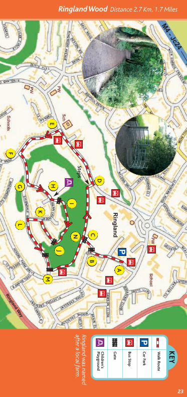
Ringland Wood Distance 2.7 Km, 1.7 Miles
23
KEY
Walk Ro
ute
Car Park
Bus Stop
Gate
Children’sPlaygro
und
P
PB
Ringland was nam
edafter a local farm
.
A
BC
D
E
F
G
I
J
K
L
M
N
B
B
B
B
B
B
B
B
BH
Steps
?
?
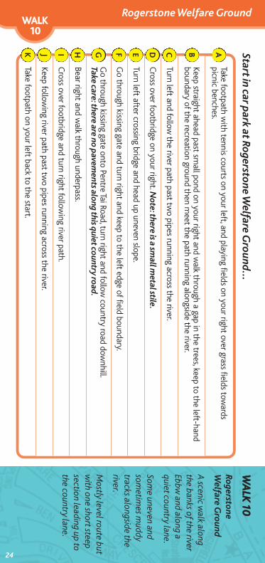
Start in car park at Rogerstone W
elfare Ground...
Rogerstone Welfare GroundWWAALLKK1100
WWAALLKK
1100
RogerstoneWelfare G
round
A scenic w
alk alongthe banks of the riverEbbw
and along aquiet country lane.
Some uneven and
sometim
es muddy
tracks alongside theriver.
Mostly level route but
with one short steep
section leading up tothe country lane.
Take footpath with tennis courts on your left, and playing fields on your right over grass fields tow
ardspicnic benches.
Keep straight ahead past small pond on your right and w
alk through a gap in the trees, keep to the left-handboundary of the recreation ground then m
eet the path running alongside the river.
Turn left and follow the river path past tw
o pipes running across the river.
Cross over footbridge on your right. N
ote: there is a small m
etal stile.
Turn left after crossing bridge and head up uneven slope.
Go through kissing gate and turn right and keep to the left edge of field boundary.
Go through kissing gate onto Pentre Tai Road, turn right and follow
country road downhill.
Take care: there are no pavements along this quiet country road.
Bear right and walk through underpass.
Cross over footbridge and turn right follow
ing river path.
Keep following river path past tw
o pipes running across the river.
Take footpath on your left back to the start.
ABCDEFGHIJK
24
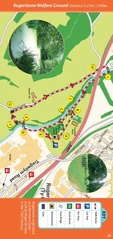
Rogerstone Welfare Ground Distance 3.2 Km, 2 Miles
25
KEY
Walk Ro
ute
Car Park
Bus Stop
Picnic Bench
Foot Bridge
Refreshments
Gate
P
P
B
B
4
4
Rogerstone originatedas a N
orman C
astlebuilt by Roger de H
aiain the 12th C
entury.
A
BC
J
K
DE
FG
H
I
B
!!
Lets Walk Newport - Healthy Start Walks
26
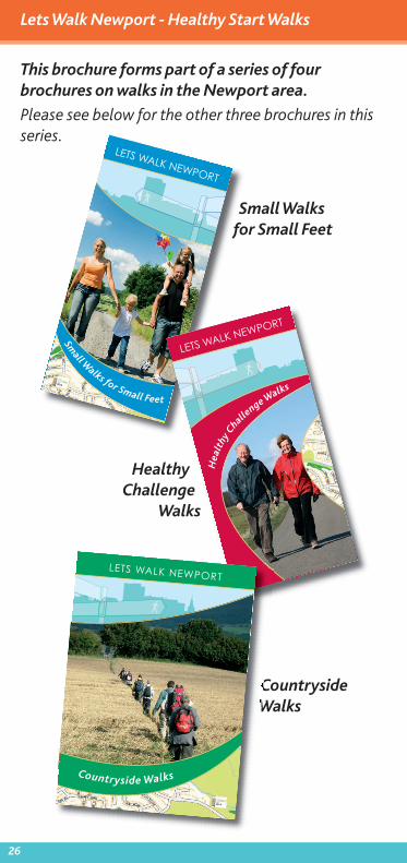
This brochure forms part of a series of fourbrochures on walks in the Newport area.
Please see below for the other three brochures in thisseries.
CountrysideWalks
LETS WALK NEWPORT
Small W
alks for Small Feet
LETS WALK NEWPORT
Hea
lthy C
hallenge Walks
HealthyChallenge
Walks
Small Walksfor Small Feet
LETS WALK NEWPORT
Countryside Walks

Lets Walk Newport - Healthy Start Walks
27
Useful Information
BBuuss && RRaaiill IInnffoorrmmaattiioonn
TTrraavveelliinnee CCyymmrruu -- 00887711 220000 2222 3333www.traveline-cymru.org.uk
OOtthheerr IInnffoorrmmaattiioonn
GGooiinngg ffoorr GGoolldd -- 0011663333 665566 [email protected]/g4g
NNHHSS DDiirreecctt OOnnlliinnee -- 00884455 4466 4477www.nhsdirect.nhs.uk
NNeewwppoorrtt LLooccaall HHeeaalltthh BBooaarrdd -- 0011663333 226611 443300www.newportlhb.wales.nhs.uk
NNeewwppoorrtt CCiittyy CCoouunncciill -- 0011663333 665566 665566www.newport.gov.uk
RRaammbblleerrss AAssssoocciiaattiioonn -- 0011663333 889944 117722www.ramblers.org.uk
GGwweenntt PPoolliiccee --0011663333 883388 111111www.gwent.police.uk
LETS WALK NEWPORT
1
2
3
4
5
67
8
9
10
Liswerry Pond
Morgans & Woodstock Pools
St. Woolos Cemetery
Caerleon Circular
Fourteen LocksCanal Walk
5
4
3
2
1 Bettws Brook
Malpas Meander
Tredegar Park
Ringland Wood
RogerstoneWelfare Grounds
10
9
8
7
6
Healthy Start Walks in Newport...
© Crown CopyrightAll rights reserved100024210.2008
Version 1. October 2008