legacy soil data from china national soil survey · legacy soil data from china national soil...
TRANSCRIPT
Legacy soil data from China national soil survey
International Conference GlobalSoilMap.net East Asia Node
8-11 February, 2012, Nanjing, China
Prof. Dr. Zhang,Wei-Li
Agric. Resources and Regional Planning Institute Chinese Academy of Agricultural Sciences

CAASChinese Academy of Agric. Sci.
MOA State
Organization &Administration
Finance

1. China soil survey in recent years2. The 2nd national soil survey of China3. Development of China soil geo-data base at
1:50,000 scale based on legacy soil data4. Discussion (revision of China soil
classification system)
Legacy soil data from China national soil survey

high fertilitymiddle fertilityLow fertilityjust for forestry & husbandry
China has limited arable land resources- arable land resource per person less than 40%
of the world average - only 30% belongs to fertile soil - keep decreasing since 1996, especially fertile
soil resources Map of soil fertility classes
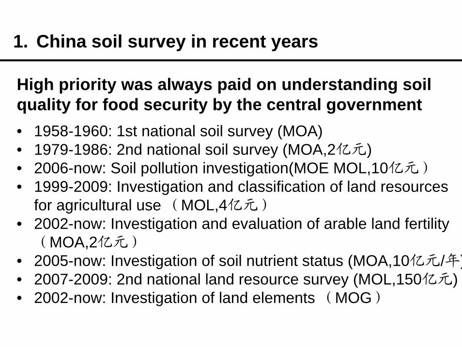
• 1958-1960: 1st national soil survey (MOA)• 1979-1986: 2nd national soil survey (MOA,2亿元)• 2006-now: Soil pollution investigation(MOE MOL,10亿元)• 1999-2009: Investigation and classification of land resources
for agricultural use (MOL,4亿元)• 2002-now: Investigation and evaluation of arable land fertility
(MOA,2亿元)• 2005-now: Investigation of soil nutrient status (MOA,10亿元/年)• 2007-2009: 2nd national land resource survey (MOL,150亿元)• 2002-now: Investigation of land elements (MOG)
1. China soil survey in recent years
High priority was always paid on understanding soil quality for food security by the central government

Sampling plans were made by using 1:10,000 scale topographic maps.
• 5 million soil profiles were observed, parent materials, morphological and other soil feature were recorded.
• 200 thousand profiles were sampled, soil texture, OM, pH, EC, N, P, K, micro nutrient contents, depth and other soil physical and chemical properties of each profile layer were analyzed and recorded
• 2 million soil samplings of tillage layer were sampled and analyzed.
2. The 2nd national soil survey of China(1979-1986)

Maps at 1:50,000 scale for 2400 counties were drafted based on observations
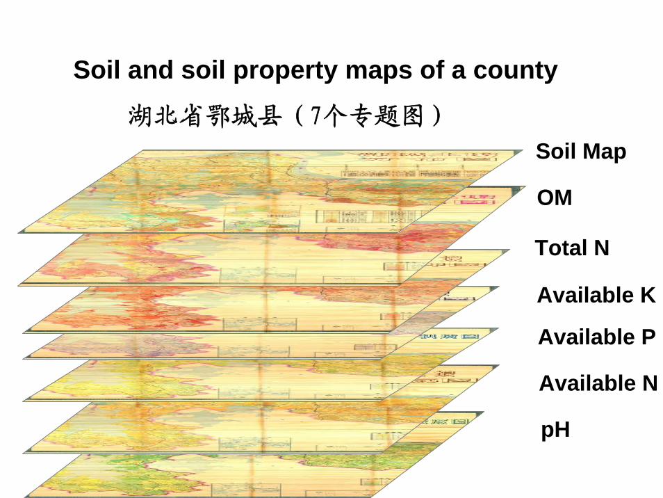
Soil mapSoil organic matter Soil total nitrogen Soil available phosphorus Soil available potassiumSoil pH
2. The 2nd national soil survey of China(1979-1986)

2、我国宝贵土壤调查资料(以纸质方式保存)正在大量丢失,迫切需要抢救、整理与保护
一、立项背景
Soil map of a county
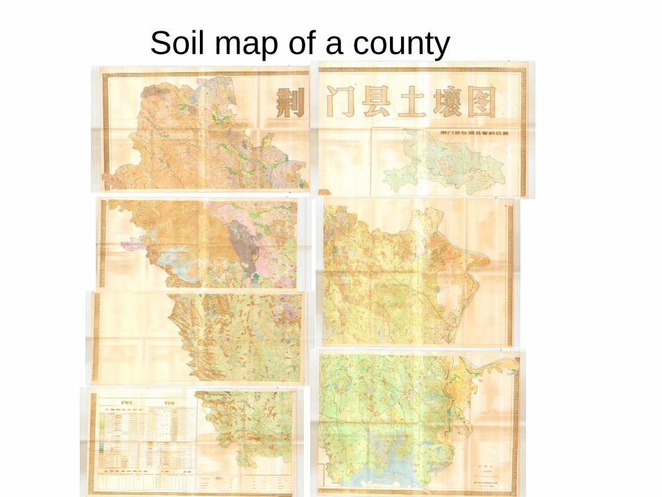
Soil map of a county
Soil Map
Available N
Total N
Available K
Available P
pH
OM
湖北省鄂城县(7个专题图)
Soil and soil property maps of a county

• Description of physical and chemical properties of soil profile

Description of physical and chemical properties of soil profile
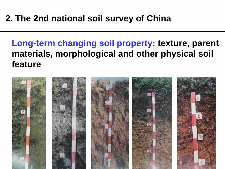
Long-term changing soil property: texture, parent materials, morphological and other physical soil feature
2. The 2nd national soil survey of China

Short-term changing soil property: OM, nutrient, tillage depth, tighten, salting etc. important for evaluate soil quality changes.
Soil parameters
1979 -1985 n 2005-
2010 n increase (%)
OM (%) 1.82 1,151,366 2.42 85,512 33%
Available P (mg/kg) 7.9 907,502 18.8 56,515 138%
Available K (mg/kg) 105 667,673 119.08 45225 13%
Change of soil OM, available P and K in China.
It means 139.9 million tons CO2 was additionally fixed in arable land annually during last 25 years..
2. The 2nd national soil survey of China

Regions with significant soil acidification from 1980s to 2010s

Main advantages of legacy soil data from 2nd soil survey ① Large quantity of field survey, field sampling and
laboratory analysisMain cropping area: one observation profile/2-7 ha
2. The 2nd national soil survey of China
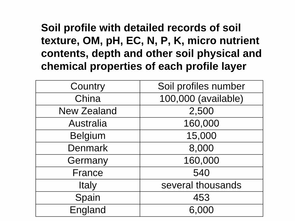
6,000England453Spain
several thousandsItaly540France
160,000Germany8,000Denmark15,000Belgium
160,000Australia2,500New Zealand
100,000 (available)ChinaSoil profiles numberCountry
Soil profile with detailed records of soil texture, OM, pH, EC, N, P, K, micro nutrient contents, depth and other soil physical and chemical properties of each profile layer

Main advantages of legacy soil data from 2nd soil survey ② One standardized approach for sampling planning,
sampling, laboratory analysis, recording and mappingClear objectives: soil resources (soil type) and fertility (fertility related property)
③ Relatively precise operation by experts.
2. The 2nd national soil survey of China
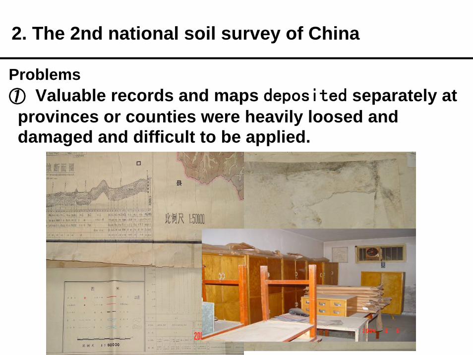
Problems ① Valuable records and maps deposited separately at provinces or counties were heavily loosed and damaged and difficult to be applied.
2. The 2nd national soil survey of China
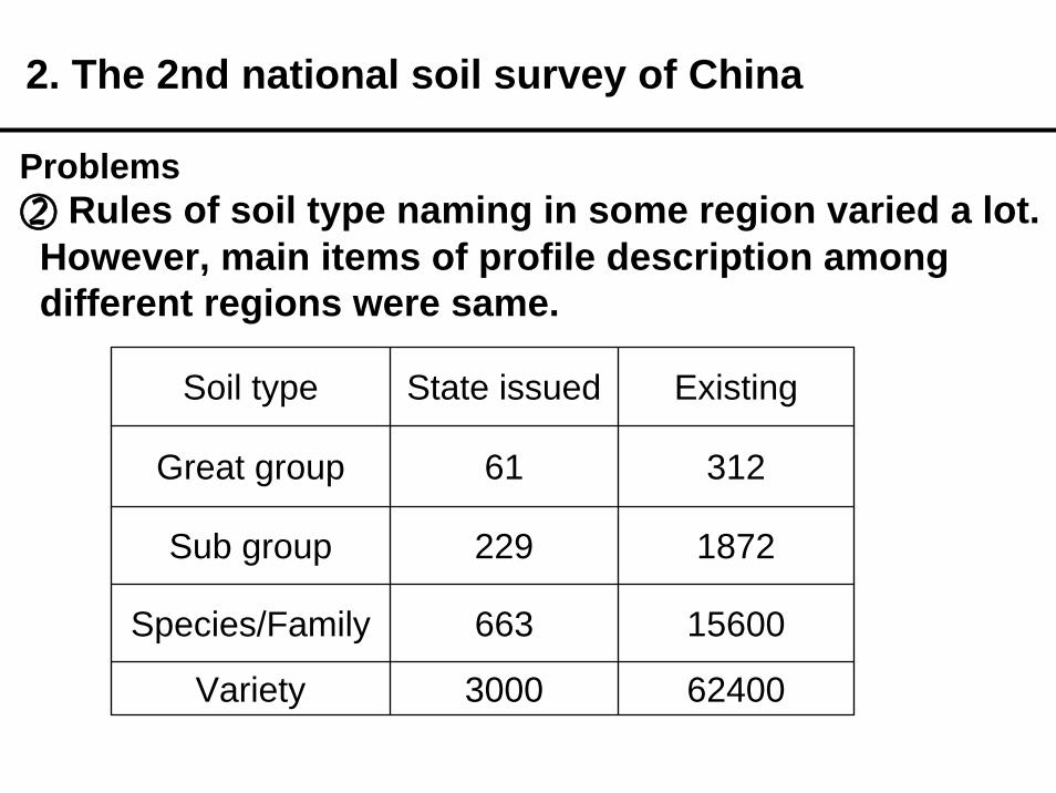
Problems ② Rules of soil type naming in some region varied a lot. However, main items of profile description among different regions were same.
2. The 2nd national soil survey of China
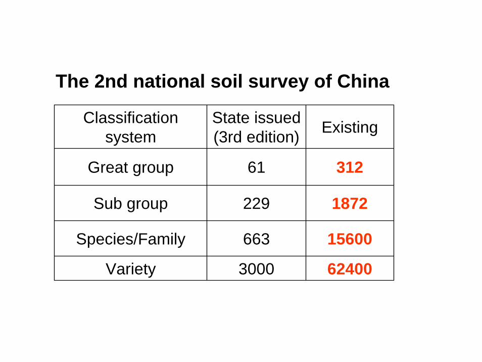
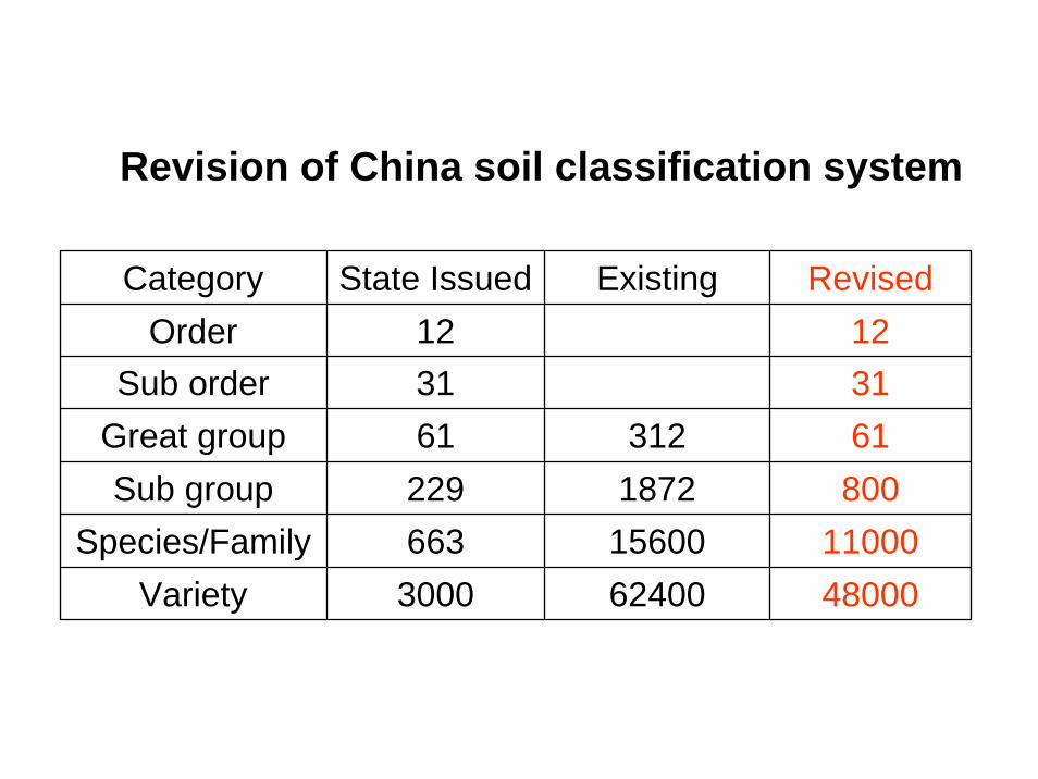
Soil type State issued Existing
Great group 61 312
Sub group 229 1872
Species/Family 663 15600
Variety 3000 62400

3. Development of China soil geo-data base at 1:50,000 scale based on legacy soil data
• Supported by many famous scientists in China and founded by MOST, development of China digital soil map at 1:50,000 scale was officially started since 2006.
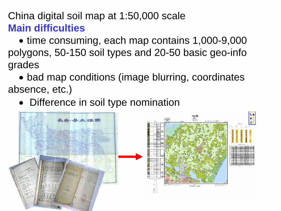
China digital soil map at 1:50,000 scaleMain difficulties
• time consuming, each map contains 1,000-9,000 polygons, 50-150 soil types and 20-50 basic geo-info grades
• bad map conditions (image blurring, coordinates absence, etc.)
• Difference in soil type nomination

3. Development of China soil geo-data base at 1:50,000 scale based on legacy soil data
• human-computer interactive data processingwere developed, which consists 106 sections• To connect each sections of the whole flow, a soil
geo-data base interface was established
3. Development of China soil geo-data base at 1:50,000 scale based on legacy soil data

2: Xb原图修复
1: Xa图件登记与元数据建库
3:Xc扫描
4:Xd图像文件处理
Data processing flow which consists 106 sections
6: Xf矢量数据
元数据建库
5: Xe建图像文件数据库
7-12:X1-6配准、矢量化,建基准库、底图库等
13:Xg图层标准化
多专题图层拆分

14: Xh矢量数据
格式标准化
16: Xj境界标准化
15: Xi坐标标准化
17: Xk属性表与
字段标准化
19: Xm三元表达式
18: Xl存储目录标准化
20:Xm1原图再现
21: Xn土类整合模型

全图分级码表达式
Gr
分幅图分级码表达式
Leg
图层与图幅关系表达式
Fra
图幅与图层文件管理表
Dir
soil geo-data base interface• contains 4 normalized documents • be able to characterize specialties and differentia
of each intermediate and the final product exactly.

By using soil geo-data base interface, a series software tools for data processing were developed

Now: integrated 1218 counties
3. Development of China soil geo-data base at 1:50,000 scale based on legacy soil data

2016
2011
3. Development of China soil geo-data base at 1:50,000 scale based on legacy soil data
w1

幻灯片 29
w17 wlzhang, 2011-10-20
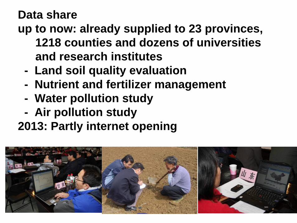
Data share up to now: already supplied to 23 provinces,
1218 counties and dozens of universities and research institutes
- Land soil quality evaluation- Nutrient and fertilizer management- Water pollution study- Air pollution study
2013: Partly internet opening

High risk Regions of groundwater Nitrate in China evaluated by use of China soil geo-data base at 1:50,000 scale

4. Discussion: Revision of China soil classification system
♦ Importance• 《 Soil Classification 》
2001, European Soil Burean• 《 Soil Genesis and Classification》
5th 6th Edition 2003,2010, Buol•《The Canadian System of
Soil Classification》3rd edition, 2011
• 《 Soil Taxonomy》USDA, Second Edition, 1999
• 《Soil Classification: A Global Desk Reference》, 2003
• Australian Soil Classification
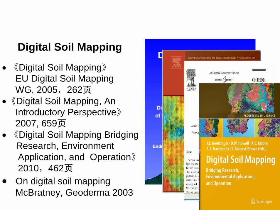
• 《Digital Soil Mapping》EU Digital Soil Mapping WG, 2005,262页
•《Digital Soil Mapping, An Introductory Perspective》2007, 659页
• 《Digital Soil Mapping Bridging Research, EnvironmentApplication, and Operation》2010,462页
• On digital soil mappingMcBratney, Geoderma 2003
Digital Soil Mapping
The 2nd national soil survey of China
Classification system
State issued (3rd edition) Existing
Great group 61 312
Sub group 229 1872
Species/Family 663 15600
Variety 3000 62400
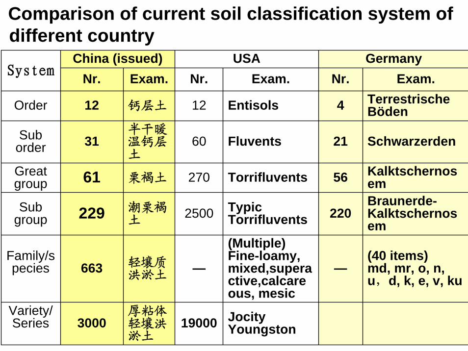
JocityYoungston19000
厚粘体轻壤洪淤土
3000Variety/ Series
(40 items)md, mr, o, n, u,d, k, e, v, ku
—
(Multiple)Fine-loamy, mixed,superactive,calcareous, mesic
—轻壤质洪淤土
663Family/species
Braunerde-Kalktschernosem
220TypicTorrifluvents2500潮栗褐
土229Subgroup
Kalktschernosem56Torrifluvents270栗褐土61Great
group
Schwarzerden21Fluvents60半干暖温钙层土
31Sub order
TerrestrischeBöden4Entisols12钙层土12Order
Exam.Nr.Exam.Nr.Exam.Nr.GermanyUSAChina (issued)
System
Comparison of current soil classification system of different country

Braunerde-Kalktschernosem
220TypicTorrifluvents2500潮栗褐
土229Subgroup
Kalktschernosem56Torrifluvents270栗褐土61Great
group
Schwarzerden21Fluvents60半干暖温钙层土
31Sub order
TerrestrischeBöden4Entisols12钙层土12Order
Exam.Nr.Exam.Nr.Exam.Nr.GermanyUSAChina (issued)
System
Soil classification system
USA:Formative element Order 12Sub order 28Great group 57

Basic thoughts for revision1. Soil classification system should be not more
complicated for soil scientists to distinguish the main soil forming process
2. Upper classes should focused on main soil forming process or elements

铁铝土纲Ferralsols
淋溶土纲Alfisols
半淋溶土纲Semi-alfisols
钙层土纲Pedocals
铁铝土 热带、亚热带,多雨,脱硅富铁铝风化
淋溶土 热带至寒温带林区,游离石灰遭充分淋洗
半淋溶土
亚热带至温带,弱淋溶,处于脱钙阶段,土体尚含游离性石灰
钙层土 温带、暖温带,半干旱与半湿润区草原土壤,腐殖质累积,有明显积钙层

干旱土纲Aridisols
漠土纲Desert soils
初育土纲Amorphic soils
半水成土纲Semi-aqueous soils
干旱土 干旱,年降雨量100~300mm
漠土 极端干旱,年降水量仅50~100mm
初育土处于成土初期的土状物质,基本为母质,无B层,有机质累积微弱
半水成土 地下水升降活动频繁

水成土纲Aqueous soils
人为土纲Anthrosols
高山土纲Alpine soils盐碱土纲
Alkali-saline soils
半水成土 地下水升降活动频繁盐碱土 土壤盐分累积或交换性钠含量高人为土 长期人为生产活动,引起土壤性质发生了质的变化
高山土 青藏高原
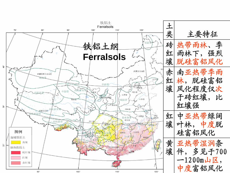
土类 主要特征
砖红壤
热带雨林、季雨林下,强烈脱硅富铝风化
赤红壤
南亚热带季雨林,脱硅富铝风化程度仅次于砖红壤,比红壤强
红壤
中亚热带绿阔叶林,中度脱硅富铝风化
黄壤
亚热带湿润条件,多见于700一1200m山区,中度富铝风化
铁铝土纲Ferralsols

61 Soil great group of China
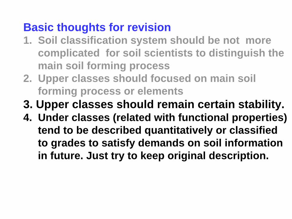
Basic thoughts for revision1. Soil classification system should be not more
complicated for soil scientists to distinguish the main soil forming process
2. Upper classes should focused on main soil forming process or elements
3. Upper classes should remain certain stability.4. Under classes (related with functional properties)
tend to be described quantitatively or classified to grades to satisfy demands on soil information in future. Just try to keep original description.
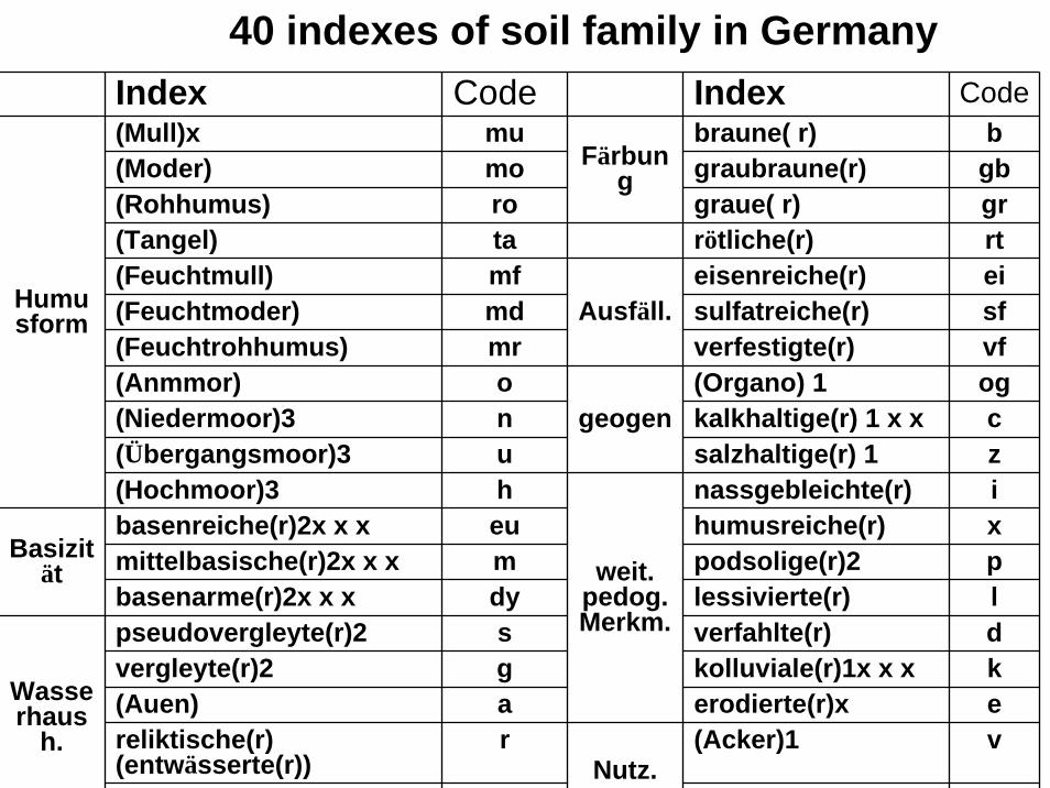
40 indexes of soil family in GermanyIndex Code Index Code(Mull)x mu braune( r) b (Moder) mo graubraune(r) gb(Rohhumus) ro graue( r) gr(Tangel) ta rötliche(r) rt(Feuchtmull) mf eisenreiche(r) ei(Feuchtmoder) md sulfatreiche(r) sf(Feuchtrohhumus) mr verfestigte(r) vf(Anmmor) o (Organo) 1 og(Niedermoor)3 n kalkhaltige(r) 1 x x c (Übergangsmoor)3 u salzhaltige(r) 1 z (Hochmoor)3 h nassgebleichte(r) i basenreiche(r)2x x x eu humusreiche(r) x mittelbasische(r)2x x x m podsolige(r)2 p basenarme(r)2x x x dy lessivierte(r) l pseudovergleyte(r)2 s verfahlte(r) d vergleyte(r)2 g kolluviale(r)1x x x k (Auen) a erodierte(r)x e reliktische(r) (entwässerte(r))
r (Acker)1 v Nutz.
Wasserhaus
h.
Basizität weit.
pedog. Merkm.
geogen
Ausfäll.
Färbung
Humusform
Revision of China soil classification system
Category State Issued Existing RevisedOrder 12 12
Sub order 31 31Great group 61 312 61Sub group 229 1872 800
Species/Family 663 15600 11000Variety 3000 62400 48000
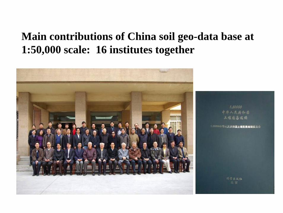
Main contributions of China soil geo-data base at 1:50,000 scale: 16 institutes together

Main works of the team in future
1. Finish whole data base 2. Develop soil property data important for crop
production and food security• Soil texture (for crop nutrient management etc.)• Soil features for irrigation equipments and
agricultural machines by use of soil morphological and other property,
