learner guide for igcse geography 0460
DESCRIPTION
Guide for igcse geography learnersTRANSCRIPT

Learner Guide for Cambridge IGCSE Geography
© Cambridge International Examinations 2012
Learner Guide for Cambridge IGCSE® Geography How to use this guide
The guide describes what you need to know about your Cambridge IGCSE® Geography examination. It will help you to plan your revision programme and will explain what we are looking for. The guide contains the following sections: Section 1: How will you be tested? This section gives you information about the different examination papers you will take. Section 2: Examination tips This section gives you advice to help you do as well as you can. Some of the tips are general advice and some are based on the common mistakes that learners make in exams. Section 3: What will be tested? This section describes the areas of knowledge, understanding and skills that we will test you on. Section 4: What you need to know This shows the syllabus content so that you can check: • which topics you need to know about • details about each topic area in the syllabus • how much of the syllabus you have covered.
Appendices This section covers other things you need to know such as:
• the importance of the command words that we use in the examination Papers • important geographical words • useful websites
Not all the information will be relevant to you. You will have to select what you need to cover in Sections (1) and (3) by finding out from your teacher whether you are doing Coursework or the alternative Paper to coursework.
IGCSE Geography Useful Websites
Learner Guide for Cambridge IGCSE Geography
© Cambridge International Examinations 2012
Section 1: How will you be tested?
1.1 About the examinations you will take
You will take three Papers: two theory Papers, i.e. Paper 1 and Paper 2, and one practical Paper, either .Paper 3 (coursework) or Paper 4 (alternative to coursework).
Your teacher will be able to tell you whether you are doing coursework (Paper 3) or taking Paper 4.
If you are doing coursework, you will complete one assignment and just take Paper 1 and Paper 2 in the examination. However, if you are not doing coursework, you will take three Papers in the examination, i.e. Paper1, Paper 2 and Paper 4.
1.2 About the theory Papers
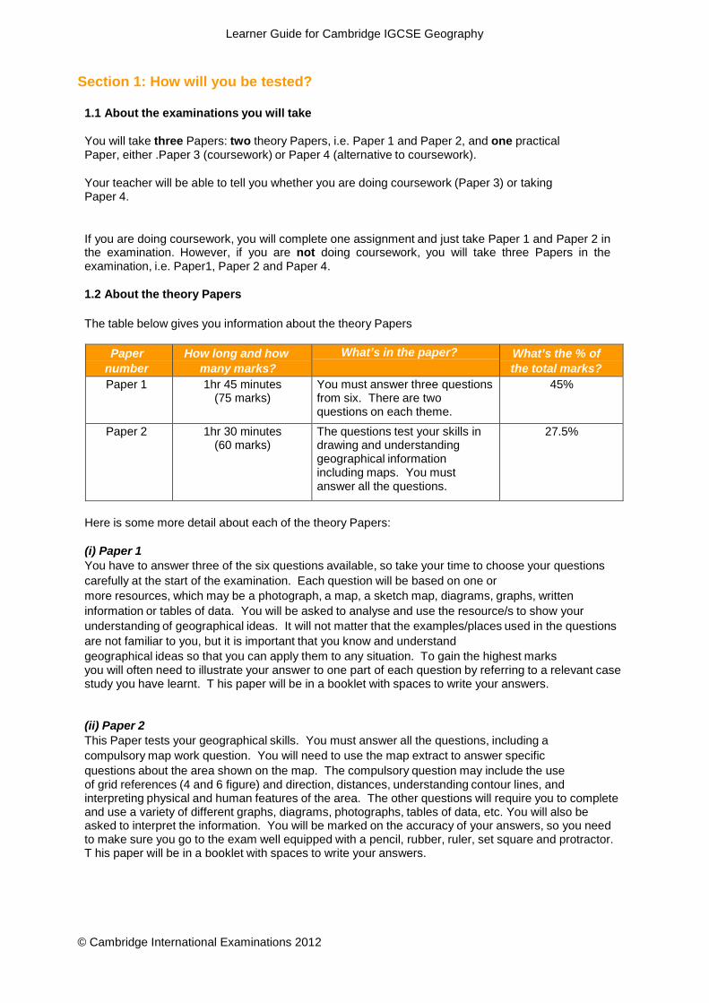
The table below gives you information about the theory Papers
Paper
number How long and how
many marks? What’s in the paper? What’s the % of
the total marks? Paper 1 1hr 45 minutes
(75 marks) You must answer three questions from six. There are two questions on each theme.
45%
Paper 2 1hr 30 minutes (60 marks)
The questions test your skills in drawing and understanding geographical information including maps. You must answer all the questions.
27.5%
Here is some more detail about each of the theory Papers:
(i) Paper 1 You have to answer three of the six questions available, so take your time to choose your questions carefully at the start of the examination. Each question will be based on one or more resources, which may be a photograph, a map, a sketch map, diagrams, graphs, written information or tables of data. You will be asked to analyse and use the resource/s to show your understanding of geographical ideas. It will not matter that the examples/places used in the questions are not familiar to you, but it is important that you know and understand geographical ideas so that you can apply them to any situation. To gain the highest marks you will often need to illustrate your answer to one part of each question by referring to a relevant case study you have learnt. T his paper will be in a booklet with spaces to write your answers.
(ii) Paper 2 This Paper tests your geographical skills. You must answer all the questions, including a compulsory map work question. You will need to use the map extract to answer specific questions about the area shown on the map. The compulsory question may include the use of grid references (4 and 6 figure) and direction, distances, understanding contour lines, and interpreting physical and human features of the area. The other questions will require you to complete and use a variety of different graphs, diagrams, photographs, tables of data, etc. You will also be asked to interpret the information. You will be marked on the accuracy of your answers, so you need to make sure you go to the exam well equipped with a pencil, rubber, ruler, set square and protractor. T his paper will be in a booklet with spaces to write your answers.

Learner Guide for Cambridge IGCSE Geography
© Cambridge International Examinations 2012
1.3 About the practical Papers
The remaining Papers for IGCSE Geography test your understanding and skills in a more practical way. They cover your knowledge of all three themes and test the skills you need to investigate geographical ideas. Your teacher will be able to tell you whether you will be entering for coursework, Paper 3 (one assignment written in your own time) or the alternative to coursework, Paper 4, which tests the same skills and knowledge as Paper 3 in a timed written examination.
Paper
number How long and how
many marks? What’s involved? What’s the % of
the total marks Paper 3 No fixed time
(60 marks) You will complete one coursework assignment. You may carry out part of the investigation and collect data as a class, BUT you must then write up the investigation on your own.
27.5% (you do either Paper 3
or Paper 4)
Paper 4 1 hr 30 minutes (60 marks)
You will answer two questions, each based on a theoretical investigation, which test how you would carry out coursework. The questions will cover data collection methods, presenting data, analysing patterns in data and writing a conclusion.
27.5% (you do either Paper 3
or Paper 4)
Here is some more detail about the practical Papers:
(i) Paper 3 (coursework) You will carry out one assignment during your Geography course, which will be assessed by your teacher. Your teacher will give you marks in five different skill areas. Each skill area is marked out of 12 marks. The teacher will look for certain indicators to assess your work.
Skill 1: Knowledge with Understanding
You will be assessed on how well you understand the geographical ideas of the investigation. You need to describe the aims of the investigation and try to explain them using geographical terms. Your teacher may suggest that you devise a hypothesis, which you then try to investigate.
Skill 2: Observation and data collection
You will be marked according to how well you carried out your data collection during the investigation, e.g. whether you followed your teacher’s instructions carefully and with thought. To gain the highest marks, you must also show some ideas of your own about data collection and observation, which go beyond those your teacher told you about.
Skill 3: Organisation and Presentation of the results
Your teacher will suggest the best way to organise your assignment, but you will also be marked on how you choose to organise and present your data, e.g. put it into graphs or display it on maps. The more varied and complicated the presentation techniques that you
Learner Guide for Cambridge IGCSE Geography
© Cambridge International Examinations 2012
use, the higher the marks that you can be given. However, you should remember that the methods must be appropriate, e.g. a bar graph may be a better technique than a line graph to compare the results of traffic surveys carried out at different places.
Skill 4: Analysis
You need to write down what your data means. The highest marks are given for both describing the patterns that you find in the data and explaining the reasons for the patterns. For example, you might write, ‘the highest traffic was found at Site X because this was the centre of the town’. If you were then to explain why the centre of the town attracted more traffic, you would be applying your geographical understanding and would be able to gain marks in the top level.
Skill 5: Conclusions and Evaluation
In the final section you will be assessed on how well you are able to conclude the investigation. Did you prove your hypothesis? What data or evidence did you find to support your concluding decisions? You will also be marked on how you criticise and evaluate your data collection methods. You can gain marks if you outline the problems you encountered whilst collecting the data and suggest better ways of collecting the information for a future investigation.
(ii) Paper 4 (alternative to coursework Paper) In this written paper you will be given the outline of two theoretical investigations. Each investigation will be based on a different theme. Data collection methods which will be used in the investigations are questionnaires, observation, measuring and recording data.
You may be asked to:
• formulate aims or hypotheses • outline how data may be collected during an investigation • plot data or complete graphs of data • describe the patterns in the statistics or graphs provided • explain the meaning of the graphs using your geographical understanding • write a conclusion to a theoretical investigation • evaluate the data collection methods used in the investigation
This Paper will be in a booklet with spaces to write your answers.

Learner Guide for Cambridge IGCSE Geography
© Cambridge International Examinations 2012
Section 2: Examination tips
Good revision is not just learning your geography but also learning how you use it to get the best grade you can.
General advice
Preparing to get a good grade begins as soon as you start your IGCSE course. You can prepare by:
• finding out what you need to know. • organizing your notes. Make a list of the topics and case studies. • knowing how your IGCSE papers are structured and practising past questions.
Your notes
• Read the rest of this guide carefully. Be really clear what topics you need to know then check
that your notes are complete and make sense. If you need further advice, speak to your teacher who will have a full copy of the Syllabus.
• Ask your teacher if you can have a copy of the syllabus, be really clear what topics you need to know then check that your notes are complete and make sense.
• Whilst there is a choice of questions on Paper 1, Papers 2 and 4 have compulsory questions so you can’t afford to have gaps in your notes just in case those topics come up.
• Try to produce an accurate set of notes when you do the work in the first place, but if you need to improve your notes you could:
• ask a friend if you can copy up work which you have missed from them – but make sure
you understand it, • find more information on topics you have studied, using your textbook, the library or the
Internet. For it to be useful make sure that you fully understand it – if not ask your teacher, • buy a good revision guide - there should be lots available in the bookshops.
Learning the work
There are lots of different ways to revise. Some people make lists, other people use diagrams and pictures. Once you know what topics to cover, you have to work out the best way to learn them.
• Make a revision timetable and plan your revision carefully so that you have time to fit
in everything you need to cover. • Work in short concentrated spells and then have a break rather than trying to work
continuously. Avoid being interrupted – don’t answer the phone/read your text messages/have a look at the TV – save it for your planned break.
Do not sit looking at your notes, or just copy them out. Try to do something active, for example you could:
• draw diagrams and sketch maps, including detailed labels, highlighting the most important points
using colours, • draw tables and charts to learn key ideas about the topic such as causes and effects,
problems and benefits and impacts on people and the natural environment which you need to learn, • draw time lines and living graphs which help you pick out how things change and explain the
reasons for the changes, • use small cards to list the main points which you need to learn, especially case studies, • use colours or highlighter pens to classify items in your notes e.g. causes/effects, long/short term
effects, effects on natural environment/people, etc,practice map skills using a variety of different maps – ask your teacher if you can borrow maps which have been used in previous examinations,
Learner Guide for Cambridge IGCSE Geography
© Cambridge International Examinations 2012
• ask your teacher for past papers and test yourself. Look at as many past papers as possible. This is not the time for you to predict questions but to find out what sort of thing is asked. Sometimes it is useful to practise writing out the answers under test conditions,
• if your teacher hasn’t explained to you how the exams are marked, ask about it. Ask if you can see questions and their mark schemes from previous examinations. Look particularly at those answers which are worth a lot of marks to discover how you can earn more marks by giving details and examples.
Answering the questions in the examination
• Make sure you use your time carefully. For example in Paper 1 there are 75 marks to get in 105
minutes, that is just under 1½ minutes per mark, but remember that includes time reading, thinking, choosing and planning as well as writing. It is no good writing a page if the question is only worth 2 marks; an answer worth 2 marks should take no more than 3 minutes to write. If you spend too long on questions which are not worth many marks it could mean you don’t have enough time to answer the questions which are worth 7 marks properly. If you do finish with time to spare re-read and check your answers adding more facts and ideas if you can remember them.
• Read the questions carefully. When you answer questions on the paper think very carefully. Try to learn how to respond to command words like IDENTIFY, DESCRIBE, EXPLAIN and COMPARE. It is important that you answer the questions and do not fall into the trap of just writing down everything you know.
• Answer the questions in order of how confident you are – leave the one you are not confident about until last.
• Do not repeat the same answer in different sections. We do not set questions which require identical answers, if you find you are repeating an answer check that you have read the question properly.
Paper 1 tips
• Look at the instructions on the front of the paper. You have to choose 3 out of the 6
questions.
• Don’t try to answer all the questions, you will not have time to answer them properly.
• Write the answers to the questions in the spaces in the question and answer booklet provided, using this as a rough guide to the amount of detail and length of answer which is needed. If you run out of space continue the answer on the spare lined sheet at the back of the booklet. Make sure you number any continuation answers carefully and also indicate that your answer is continued on the extra page at the end of your partly written answer.
• Look at the number of marks available for each part of a question. Don’t spend too
much time on one part if it is only worth one or two marks, or alternatively write only a short answer when a question is worth more marks. Timing is important, don’t spend too much time on your first chosen question, otherwise you will have to rush the last question. Just in case you run out of time, if there is a question which you are not confident on, answer it last.
• Read the information given in the stem of the question carefully as well as
the questions themselves.
• Wherever possible in your answers try to include relevant examples and case studies. There may be local examples which you could use in your answers.
• Where you are asked to complete an answer by labelling or drawing on a resource
you must do this rather than writing an answer. If you use any extra sheets make sure that you put your name on them and attach them to your answer booklet before handing it in.

Learner Guide for Cambridge IGCSE Geography
© Cambridge International Examinations 2012
• When you are asked to use a written resource you will not be given marks for
copying out sections from it. Look at the question which is set and try to show your understanding by answering in your own words.
• If you are asked to compare or describe the differences between two things it is no good just writing about one. You could use words like `bigger` or `more` to help you compare or a word like `whereas` in the middle of your sentence (e.g. ` a constructive wave deposits material on the coast whereas a destructive wave erodes material from it`.)
• Try to be as precise as possible as vague statements are unlikely to get you many marks. e.g.`A Stevenson Screen is used to get accurate readings` is far too vague. You need to give details explaining why readings are accurate when a Stevenson Screen is used (e.g. the louvres allow a free flow of air, the white surface reflects the sun`s rays, it allows you to take temperatures in the shade etc).
• Make sure you know the differences between global environmental problems which you may
have studied. Many people mix up global warming, ozone depletion and acid rain. You must also make sure you don’t mix up causes and effects/consequences – you may be asked for one or the other so read the question carefully.
Paper 2 tips
• This paper is testing different skills. Try to be as accurate as you can with
measuring and plotting. Take your time, take care and always use a ruler to complete graphs and measure straight line distances.
• Many questions ask you to `use the evidence` in the resources provided such as the
maps, photographs and graphs. You must make sure that you do so rather than using your background knowledge. (e.g. if you are asked to describe the features of an industry shown in a photograph there is no need to include general information about that industry and its location.
• If you are asked to describe features of a coastal area shown on a map there is no
point explaining how they were formed. If you are asked to use evidence from the map to explain why there are no settlements in some areas there is no point in referring to the climate as the map extract is unlikely to include information about it.)
• Practise the basic map skills, for example 6 figure grid references. People sometimes get the third and sixth figures confused. Make sure you give the reference for the position of the symbol rather than the name of the place.
• If you are asked to measure a distance it is worth using the linear scale below the
map and a straight edged piece of paper. By doing this you will be less likely to make the mistakes which are possible when using calculation to convert centimetres to kilometres and metres. Look carefully at what units you need to use, whether you should answer to the nearest kilometre or in metres. Make sure you always give the units rather than just writing down the number.
• You could be asked to give a direction or a compass bearing. Make sure you know
the difference and check which of the features you are measuring from and to by looking carefully at the wording of the question.
• If you are asked to draw a graph be as accurate as you can, measuring carefully

Learner Guide for Cambridge IGCSE Geography
© Cambridge International Examinations 2012
and using a ruler. Take care to draw the type of graph which the question asks for rather than a different type of graph.
• Make sure you know how to draw and read a divided bar graph; it is used in a different way
from a normal bar graph.
Paper 4 tips
• Don’t forget that this paper is an alternative to coursework. To prepare for it you need to be able to answer questions about collecting, presenting and analysing data like you would do in a geographical investigation. There is nearly always a question that asks you to write a conclusion and an evaluation. You need to practise these skills.
• Many of these questions are based on a hypothesis. Make sure you are familiar with testing hypotheses.
• You will be given resources to use in the examination which you have not seen before, perhaps
different types of graphs or diagrams. Look at the diagrams carefully and think carefully about what they are showing before you answer the questions. You may be asked to complete a diagram, in which case you need to complete it accurately and carefully.
• You will have to answer questions about data which has already been collected as part of an
investigation. This could be a set of figures or graphs or maps. One of the things you will be asked to do is to recognize and describe patterns or trends (e.g. the distribution of rainfall over an area as shown on a map or over time as shown on a graph, the amount of erosion alongside a footpath as shown on a diagram). You should practise this skill, using data which you have collected yourself, or data from your teacher.
• If you are asked questions about the data in the resources you will be expected to use that data
rather than simply listing or repeating the figures. (e.g. you may be asked to compare two sets of data about different places, look for a relationship between two or more sets of data or recognize similarities and differences). However it is always useful to support your answer by quoting data from the source you are using.
• Learn about the different types of samples which can be used when collecting data – you may be
asked to describe the advantages of using systematic or stratified sampling for example. Many candidates assume that the only sample which can be taken is a random sample.
• You may be asked to suggest practical ways by which something could be improved. This could
be an actual investigation or something which has been investigated (e.g. the amount and distribution of pollution in a river). You will be expected to be realistic in your suggestions so always think about whether they are practical. For example to suggest that all the residents of a town should be interviewed rather than taking a sample is unrealistic. Similarly to suggest that all factories alongside the river are shut down is not a suggestion which is practical.
• When asked to write a conclusion you need to look at the evidence and then say whether you
think the hypothesis is correct or not. In a few cases it may be only partly correct. You must then give evidence to support your conclusion. This evidence must be based on the data provided in the question.
Learner Guide for Cambridge IGCSE Geography
© Cambridge International Examinations 2012
Section 3: What will be tested?
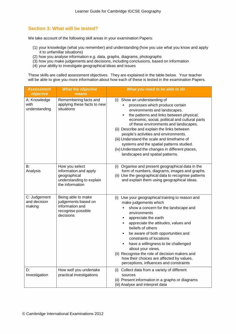
We take account of the following skill areas in your examination Papers:
(1) your knowledge (what you remember) and understanding (how you use what you know and apply it to unfamiliar situations)
(2) how you analyse information e.g. data, graphs, diagrams, photographs (3) how you make judgements and decisions, including conclusions, based on information (4) your ability to investigate geographical ideas and issues
These skills are called assessment objectives. They are explained in the table below. Your teacher will be able to give you more information about how each of these is tested in the examination Papers.
Assessment
objective What the objective
means What you need to be able to do
A: Knowledge with understanding
Remembering facts and applying these facts to new situations
(i) Show an understanding of • processes which produce certain
environments and landscapes. • the patterns and links between physical,
economic, social, political and cultural parts of these environments and landscapes.
(ii) Describe and explain the links between people’s activities and environments.
(iii) Understand the scale and timeframe of systems and the spatial patterns studied.
(iv) Understand the changes in different places, landscapes and spatial patterns.
B: Analysis
How you select information and apply geographical understanding to explain the information
(i) Organise and present geographical data in the form of numbers, diagrams, images and graphs.
(ii) Use the geographical data to recognise patterns and explain them using geographical ideas.
C: Judgement and decision making
Being able to make judgements based on information and recognise possible decisions
(i) Use your geographical training to reason and make judgements which • show a concern for the landscape and
environments • appreciate the earth • appreciate the attitudes, values and
beliefs of others • be aware of both opportunities and
constraints of locations • have a willingness to be challenged
about your views. (ii) Recognise the role of decision makers and
how their choices are affected by values, perceptions, influences and constraints
D: Investigation
How well you undertake practical investigations
(i) Collect data from a variety of different sources
(ii) Present information in a graphs or diagrams (iii) Analyse and interpret data

Learner Guide for Cambridge IGCSE Geography
© Cambridge International Examinations 2012
Section 4: What you need to know
The table describes the things you may be tested on in the examination. It is arranged in three Themes with several topic areas within each Theme. Each topic is divided up into sections, which contain the detail that you need to know.
How to use the table
You can use the table throughout your course to check the topic areas you have covered. You can also use it as a revision aid. When you think you have a good knowledge of a topic, you can tick the appropriate box in the checklist column.
Test yourself as follows:
• cover up the details with a piece of paper • try to remember the details • when you have remembered the details correctly, put a tick in the appropriate box
If you use a pencil to tick the boxes, you can retest yourself whenever you want by simply rubbing out the ticks. If you are using the table as a checklist of which topics you have covered, you can put a tick in the topic column next to the appropriate bullet point.
The column headed Comments can be used:
• to add further information about the details for each bullet point • to add learning aids e.g. CASH (for corrosion, attrition, solution, hydraulic action) • to highlight areas of difficulty/ things which you need to ask your teacher about

Learner Guide for Cambridge IGCSE Geography
© University of Cambridge International Examinations 2012
Theme 1. Population and Settlement 1.1 Population dynamics
Topic outline You should be able to: Checklist Comments or named case study examples Population increase
Describe and suggest reasons for the rapid increase in the world’s population in recent times (known as ‘the population explosion’)
Factors influencing population increase
Define the main components influencing the population growth:
• Birth Rate
• Death rate
• Migration
How and why is population growth linked to resources?
Describe the relationship between population growth and resources.
Explain why problems may result in some areas such as over-population and under-population.
Why do populations grow at different rates?
Identify and suggest reasons for contrasting patterns of population growth in different world areas as influenced by differences in birth rate, death rate and migration.
You should illustrate these factors by making reference to selected examples. Social, economic and other factors to be considered are, for example:
• Government policies and their impact upon birth
rates
• Differences in health care
• Social and other factors influencing death rates
• The impact of HIV/AIDS

Learner Guide for Cambridge IGCSE Geography
© University of Cambridge International Examinations 2012
Theme 1. Population and Settlement
What are the problems and benefits of different patterns of population growth?
Describe the consequences (benefits and problems) of different patterns of population growth.
You should give consideration to variations in the size and nature of dependent populations and standards of living.
Population structure
Identify and suggest reasons for different types of population structure (age-sex pyramids).
You should be able to describe population pyramids and relate them to the different stages of the Demographic Transition Model.
What influences population density and distribution?
Identify the major influences on:
• population density
• population distribution
You should make reference to physical, economic and human factors.
How and why do people move?
Describe and suggest reasons for population movements. You should make reference to:
• internal movements such as rural-urban migration
• international movements, both voluntary and
involuntary

Learner Guide for Cambridge IGCSE Geography
© University of Cambridge International Examinations 2012
Theme 1. Population and Settlement 1.2 Types of Settlement
Topic outline You should be able to: Checklist Comments or named case study examples Describe and explain the factors influencing the size, development and function of urban and rural settlements and their spheres of influence.
Describe the patterns of rural settlements - dispersed, linear and nucleated.
Explain how physical factors (relief, soil, water supply) and other factors such as accessibility, agricultural land use, influence the sites and patterns of rural settlements.
Describe and explain the factors, which may influence the size, growth and functions of rural and urban settlements.
Describe and suggest reasons for the hierarchy of settlements and services.
Describe and give reasons for the characteristics of land use zones of urban areas in LEDCs and MEDCs.
Describe and explain the land use zones of towns and cities to include:
• Central Business District (CBD)
• residential areas
• industrial areas
• the provision of open spaces
• transport routes
Differences in the patterns of urban structures in cities of LEDCs and MEDCs should be identified.

Learner Guide for Cambridge IGCSE Geography
© University of Cambridge International Examinations 2012
Theme 1. Population and Settlement
Describe the problems of urban areas in MEDCs and LEDCs, their causes and possible solutions.
Describe problems associated with the growth of urban areas such as:
• congestion in the CBD
• housing shortages
• traffic congestion
• squatter settlements
You should make reference to selected examples to illustrate suggested solutions to overcome these problems.
Describe the impact on the environment resulting from urbanisation and possible solutions to reduce this impact.
Describe the effects of urbanisation on the environment:
• pollution (air, water, visual and noise)
• the results of urban sprawl on surrounding areas
• the growth of out-of-town urban activities - shopping areas, sports facilities, etc.
Learner Guide for Cambridge IGCSE Geography
© University of Cambridge International Examinations 2012
Theme 2. The Natural Environment 2.1 Structure, landforms and landscape processes
Topic outline You should be able to: Checklist Comments or named case study examples
Structure Where are earthquakes, volcanoes and fold mountains located?
Describe the general distribution of fold mountains, volcanoes and earthquakes and explain how this distribution is related to movements at plate boundaries.
Describe the causes and effects of earthquakes and volcanic eruptions
Show a basic understanding of plate tectonics, describing the global pattern of plates, their structure, and be aware of plate movements and their effects:
• plates moving away from each other (sea floor
spreading)
• plates moving towards each other (subduction)
• plates sliding past each other
Weathering Describe weathering processes and explain the landforms associated with these processes.
Recognise that weathering involves the breakdown of rock in situ, and as such should be distinguished from erosion.
Describe what is meant by different types of weathering:
• physical/mechanical (freeze-thaw action, exfoliation)
• chemical (carbonation, oxidation)
• biological

Learner Guide for Cambridge IGCSE Geography
© University of Cambridge International Examinations 2012
Theme 2. The Natural Environment
Explain the main factors influencing the type and rate of weathering (climate and rock features), for instance:
• mineral composition
• grain size of the rock
• presence of lines of weakness
You could illustrate the influence of climate on the rate of weathering by making reference to a simple explanation as to why weathering is more rapid in humid tropical regions of the world than in temperate regions.
River Processes
Describe river processes and explain the landforms associated with them.
Demonstrate an understanding of the work of a river in eroding, transporting and depositing. You should make reference to the erosional processes of:
• hydraulic action
• corrasion
• corrosion (solution)
• attrition
River transport should include the processes of traction, saltation, suspension and solution.
You should study reasons why and where in a river's course deposition takes place.
You should also realise that the effectiveness of the river processes will vary according to the volume and velocity of the running water and the nature of the load (boulders, pebbles, sand and silt), which in turn will be affected by the bedrock along the course of the river.

Learner Guide for Cambridge IGCSE Geography
© University of Cambridge International Examinations 2012
Theme 2. The Natural Environment
Describe and explain the landforms associated with these processes. You should study the following:
• Forms of river valleys - long profile and shape in
cross section.
• Rapids.
• Waterfalls and potholes.
• Meanders, oxbow lakes.
• Deltas, levées and flood plains.
Marine Processes
Describe marine processes and explain the associated landforms.
Demonstrate an understanding of wave processes in eroding a coastline and re-sorting and depositing materials removed through erosion.
You should show an understanding of:
• the types of waves (constructive and destructive)
• the components of waves (swash and backwash)
The erosional processes of wave action should include an understanding of:
• hydraulic action
• corrasion
• corrosion (solution)
• attrition
Show an appreciation of the transport of material along the coastline, onshore and offshore movements, together with an understanding of movement along a coastline (longshore drift).

Learner Guide for Cambridge IGCSE Geography
© University of Cambridge International Examinations 2012
Theme 2. The Natural Environment
The action of wind in shaping coastal sand dunes should also be understood.
Describe and explain the landforms associated with these processes. You should study the following coastal landforms
• cliffs and wave-cut platforms
• caves, arches, stacks
• bay and headland coastlines
• beaches, spits and bars
• coastal sand dunes and marsh
Describe the conditions required for the development of coral reefs.
Describe
• fringing and barrier reefs
• atolls

Learner Guide for Cambridge IGCSE Geography
© University of Cambridge International Examinations 2012
Theme 2. The Natural Environment 2.2 Weather, Climate and Natural Vegetation
Topic outline You should be able to: Checklist Comments or named case study examples
Weather Describe the methods of collecting and measuring meteorological data.
Draw, describe and explain the use and siting of the following instruments at a weather station:
• rain-gauge
• maximum-minimum thermometer
• wet and dry bulb thermometer (hygrometer)
• barometer
• anemometer and wind vane
Make calculations using information from these instruments.
Use and interpret graphs and other diagrams showing weather data.
Describe and explain the characteristics, siting and use made of a Stevenson screen.
Describe the main types of cloud and be able to estimate the extent of cloud cover.
Learner Guide for Cambridge IGCSE Geography
© University of Cambridge International Examinations 2012
Theme 2. The Natural Environment Climate Describe and
explain the characteristics of the climate and natural vegetation.
Describe and explain the main characteristics of the climate in:
(i) tropical rain (evergreen) forests (ii) tropical deserts
by:
• temperature - mean temperature of the hottest month, mean temperature of the coolest month, therefore the annual range;
• rainfall - the amount and seasonal distribution
• other climate features - wind, cloud, humidity etc.
You should note factors influencing these characteristics, such as latitude, pressure systems and the winds to which they give rise, distance from the sea, altitude and ocean currents.
You should be familiar with climatic graphs showing the main characteristics of temperature and rainfall of the climates in the regions listed.
Ecosystems Describe and explain the relationship between the climate and natural vegetation
Describe the two type of ecosystems (i.e. tropical rain (evergreen) forest and tropical desert) in terms of:
• distribution
• characteristics
Explain the relationship of each type of natural vegetation to to features of the climates outlined above.

Learner Guide for Cambridge IGCSE Geography
© University of Cambridge International Examinations 2012
Theme 2. The Natural Environment 2.3 Inter- relationships between the natural environment and human activities
Topic outline You should be able to: Checklist Comments or named case study examples Demonstrate the interaction between the natural environment and human activities, with reference to natural hazards, landscape processes, climate and the named types of natural vegetation
Demonstrate an understanding that the natural environment presents:
• hazards
• offers opportunities for human activities.
You could make reference, for example, to the hazards posed by volcanic eruptions, earthquakes, tropical storms, flooding and drought.
You could use contemporary examples to illustrate such hazards and opportunities. This would also give you valuable case study information.
You could refer to the opportunities and problems posed for people when you are studying the natural environment, for example the advantages and difficulties offered by river flood plains and deltas.
You should consider the impact of human activities on the two ecosystems (i.e. tropical rain (evergreen) forest and tropical desert).

Learner Guide for Cambridge IGCSE Geography
© University of Cambridge International Examinations 2012
Theme 3. Economic Development and the Use of Resources 3.1 Agricultural systems
Topic outline You should be able to: Checklist Comments or named case study examples Describe and identify the influence of inputs (natural and human) on the processes and outputs of agricultural systems.
Describe in general terms the main features of an agricultural system: inputs, processes and outputs.
Describe the influence of natural and human inputs on the processes and outputs of the agricultural systems listed in the Syllabus:
(i) a large-scale system of commercial farming
(ii) small-scale subsistence farming
Your studies should include:
• natural inputs (relief, climate and soil)
• human inputs (economic, social and sometimes political).
You should study their combined influences on the:
• scale of production
• methods of organisation
• products of each system
In each case you should make reference to a detailed case study of a large-scale system of commercial farming, such as:
• plantation agriculture
• extensive commercial cereal farming
• extensive livestock production
Learner Guide for Cambridge IGCSE Geography
© University of Cambridge International Examinations 2012
Theme 3. Economic Development and the Use of Resources
And also a detailed case study of a small scale system of subsistence farming, such as:
• intensive subsistence rice cultivation
• shifting cultivation
You may select illustrations other than those listed above.

Learner Guide for Cambridge IGCSE Geography
© University of Cambridge International Examinations 2012
Theme 3. Economic Development and the Use of Resources 3.2 Industrial systems
Topic outline You should be able to: Checklist Comments or named case study examples Recognise the causes and effects of shortages of food and describe possible solutions to this problem.
Recognise the causes and effects of food shortages. Shortages of food may be related to natural problems such as soil exhaustion, drought, floods, tropical cyclones, pests, disease etc.
You should be aware of the effects of these natural problems on selected areas within LEDCs.
You should note economic and political factors and their effects upon food shortages for example
• low capital investment
• poor distribution/transport difficulties
• wars etc.
You should consider the effects of food shortages in encouraging food aid and measures, such as those of the 'Green Revolution' to produce more food.
Classify industries into primary, secondary and tertiary.
Classify and give illustrations of:
• primary industry
• secondary industry
• tertiary industry
How do the proportions employed in different sectors change with time and level of development?
Describe and explain how the proportions employed in each sector changes with respect to the level of development, including Newly Industrialised Countries (NICs).

Learner Guide for Cambridge IGCSE Geography
© University of Cambridge International Examinations 2012
Theme 3. Economic Development and the Use of Resources
Describe and identify the influence of inputs on the processes and outputs of industrial systems
Demonstrate an understanding of an industrial system:
• inputs
• processes
• outputs (products and waste)
Specific illustrations should be studied of
• high technology industries
• one other processing/manufacturing industry
Describe and explain the factors influencing the distribution and location of high technology and one other manufacturing /processing industry
Describe the factors to be considered when seeking the location and siting of:
• high technology industries
• the other processing/manufacturing industry
selected
You should study distribution on a global/ national scale.
Learner Guide for Cambridge IGCSE Geography
© University of Cambridge International Examinations 2012
Theme 3. Economic Development and the Use of Resources 3.3 Leisure activities and tourism
Topic outline You should be able to: Checklist Comments or named case study examples Describe and account for the growth of leisure facilities and tourism
Describe and explain the growth of leisure facilities and tourism in relation to the main attractions of the physical and human landscape in an area or areas selected for study.
Assess the benefits and disadvantages of tourism to receiving areas.
Demonstrate an understanding that the effects of a growth in tourism are generally positive and that careful management is needed if problems are to be avoided.
You should select a sample study to illustrate both the benefits and disadvantages associated with the growth of tourism. You could make reference to advantages accruing from tourism such as:
• growth in income
• an increase in foreign exchange
• employment opportunities
• the development of infrastructure
• facilities which may be used by the local population
• the encouragement of other developments to take
place in an area
• cultural advantages etc.

Learner Guide for Cambridge IGCSE Geography
© University of Cambridge International Examinations 2012
Theme 3. Economic Development and the Use of Resources
Disadvantages might include
• seasonal unemployment
• under-use of facilities at certain times of the year
• increased congestion
• pollution
• a shortage of services e.g. water supplies
• social/cultural problems
• damage to the physical landscape etc.
Learner Guide for Cambridge IGCSE Geography
© University of Cambridge International Examinations 2012
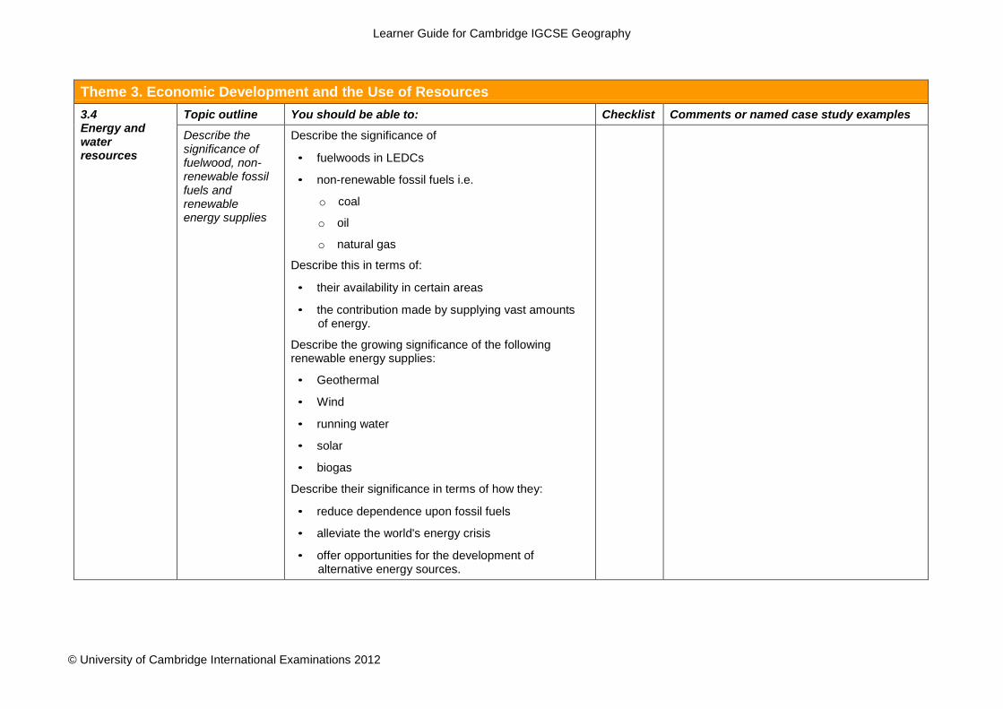
Theme 3. Economic Development and the Use of Resources 3.4 Energy and water resources
Topic outline You should be able to: Checklist Comments or named case study examples Describe the significance of fuelwood, non- renewable fossil fuels and renewable energy supplies
Describe the significance of
• fuelwoods in LEDCs
• non-renewable fossil fuels i.e.
o coal
o oil
o natural gas
Describe this in terms of:
• their availability in certain areas
• the contribution made by supplying vast amounts of energy.
Describe the growing significance of the following renewable energy supplies:
• Geothermal
• Wind
• running water
• solar
• biogas
Describe their significance in terms of how they:
• reduce dependence upon fossil fuels
• alleviate the world's energy crisis
• offer opportunities for the development of alternative energy sources.
Learner Guide for Cambridge IGCSE Geography
© University of Cambridge International Examinations 2012
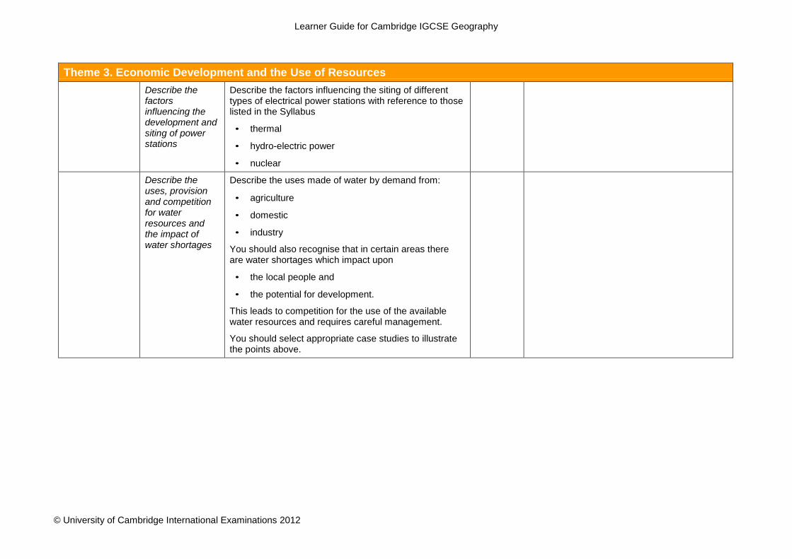
Theme 3. Economic Development and the Use of Resources
Describe the factors influencing the development and siting of power stations
Describe the factors influencing the siting of different types of electrical power stations with reference to those listed in the Syllabus
• thermal
• hydro-electric power
• nuclear
Describe the uses, provision and competition for water resources and the impact of water shortages
Describe the uses made of water by demand from:
• agriculture
• domestic
• industry
You should also recognise that in certain areas there are water shortages which impact upon
• the local people and
• the potential for development.
This leads to competition for the use of the available water resources and requires careful management.
You should select appropriate case studies to illustrate the points above.

Learner Guide for Cambridge IGCSE Geography
© University of Cambridge International Examinations 2012
Theme 3. Economic Development and the Use of Resources 3.5 Environmental risks and benefits: resource conservation and management
Topic outline You should be able to: Checklist Comments or named case study examples Demonstrate the need for sustainable development, resource conservation and management in different environments
Demonstrate the need for sustainable development, resource conservation and management in different environments.
Note: It is not intended that you should be familiar with a wide variety of illustrations here. You should use well- selected case studies to become familiar with the general principles and use these to illustrate your answer.
Describe how human activities may improve the quality of life and/or pose threats to the environment
Identify and describe the benefits associated with the development of:
• agriculture
• extractive industries
• manufacturing industries
• energy production
• tourism
• transport
This could be incorporated with the studies outlined above in 3.1 - 3.4. Please ask your teacher to advise you.
Describe how these developments may also pose threats to the environment when natural ecosystems are interfered with including:
• soil erosion
• global warming
• air, water, noise and visual pollution

Learner Guide for Cambridge IGCSE Geography
© University of Cambridge International Examinations 2012
Theme 3. Economic Development and the Use of Resources
What areas are at risk from development?
Identify areas at risk from these threats to the environment.
How can the environment be maintained, conserved or improved?
Describe attempts made to maintain, conserve or improve the quality of the environment.
Learner Guide for Cambridge IGCSE Geography
© University of Cambridge International Examinations 2012
Appendices
Command words and phrases used in Geography examination Papers
We use command words to help you to understand what they are looking for in your answers. This table explains what each of these words or phrases means and will help you to understand the kind of answer you should write. The list of command words is in alphabetical order. You should remember that the meaning of a term may vary slightly depending on how the question is worded.
Annotate You have to add labels of notes or short comments to a diagram, map or
photograph. More than one word is needed. Calculate You need to give a numerical answer. You should show your working,
especially where two or more steps are involved. Compare You have to identify similarities and differences. Usually you need to look
carefully at two or more sets of data, places, features or geographical ideas, then explain how they are similar and how they are different.
Complete You need to add the remaining details. e.g. finish a graph using the data or finish a statement, which has been started for you.
Define You need to state the meaning of something. e.g. Longshore drift is the movement of material along the coast.
Describe You need to state the main points about something, (to say what it is like). e.g. describe the movement of a pebble along a beach.
You may also be asked to describe: • observations e.g. describe what is shown on the photograph • patterns e.g. describe the change shown by the rainfall data • processes e.g. describe how a waterfall is formed
Describe is often used with other command words. e.g. Name and describe [name the feature and write the factual details of]. e.g. Describe and explain [set out the factual details and give reasons for].
Draw You should produce a simple line drawing. The most important points should be shown and usually you should label them. e.g. Draw and label a diagram to show a nucleated settlement.
Explain or Account for
(i) You have to give reasons for your answer. OR
(ii) refer to a particular geographical theory e.g. explain why rainfall is higher in areas of high altitude
Identify You have to recognise a specific feature or features shown, for example, on a graph, photograph, map or text, e.g. identify the spit.
Illustrating your answer
(i) You should use specific examples or case studies to support your comments.
OR (ii) You need to produce a labelled diagram to show the important points.
Insert or Label You should add specific names or details to show a feature or features.

Learner Guide for Cambridge IGCSE Geography
© University of Cambridge International Examinations 2012
List Write down a number of separate points. Where the number of points is stated, you should not write more than this number e.g. list two advantages of random sampling.
Locate You have to find a place, usually on a map or graph. Measure (i) You need to find a quantity using the measuring instrument given
e.g. the maximum temperature from the max/min thermometer OR
(ii) calculate the distance on a map using the scale Name You have to state or identify or give examples which illustrate a specific
feature. Outline Give the main points briefly.
e.g. outline the impact of an deforestation on the local people. Pattern A particular arrangement or distribution
e.g. settlements. You may be asked to suggest a pattern or identify a pattern (or trend).
Refer to/With reference to
You should use some of the ideas from the resources provided in the question, or examples from your case study information.
State You should give a short answer without going into any detail. e.g. state the type of migration when people move between countries.
Study You should look carefully at the information provided to answer the question. The examiner is often telling you where to find the answer.
Suggest (i) You should give your opinion based on the information given in the question. e.g. suggest where a split may develop.
(ii) You should apply your geographical knowledge or reasoning skills to a question. e.g. suggest why the shop was located in this area.
Use or Using the information provided
You should base your answer on the information provided.
Why You should state or give detailed reasons. This word is often used instead of explain.
Learner Guide for Cambridge IGCSE Geography
© University of Cambridge International Examinations 2012
IGCSE Geography Useful Websites The websites listed below are useful resources to help you study for your Geography IGCSE.
http://www.geographyalltheway.com
This is a wide-ranging site which includes good coverage of the content of the 0460 IGCSE Geography
syllabus, which will be useful both to teachers and learners. The approach is lively and there is basic no-
nonsense text as well as some good photos, maps, diagrams, links to YouTube and even a few worksheets.
Population dynamics and general
http://www.nationmaster.com
A useful website to compare different LEDC and MEDC countries using a wide range of statistics. You can
choose which countries or continents to compare and select different statistics including population, economy,
agricultural information and environmental pollution data. A bar graph is drawn to show the chosen statistics
and the results are mapped. There are further links on your chosen countries giving further information.
Structure and inter relationships of physical and human geography
http://www.usgs.gov
This is a USA based site and has a lot of good, up to date information on the structure of the earth and the
hazards of Volcanoes and Earthquakes. On the home page, go to the alphabetical index and find ‘volcanic
activity’ or ‘earthquakes’. The FAQs are good for revision or further explanation. The hazards section provides
useful case study information. The most exciting feature of this website is the links for daily monitoring of
volcanoes and earthquakes i.e. to see what seismic activity is going on at that precise moment. You can follow
the links for a specific US area e.g. Alaska or select a world map of seismic activity at
http://www.earthquake.usgs.gov/recenteqsww/. By clicking on the map you can obtain further information about
the depth and magnitude of the recent earthquake.
http://www.georesources.co.uk
This is a ‘portal’, i.e. a site which contains useful links to other sites but with a comment on how useful it might
be to your studies. It is a very easy site to use. Follow the GCSE link to a list of topics. Select the topic you are
studying to find additional information or case study material. This is an English based site and the case
studies are often from the UK but it does contain many worldwide examples. The ‘Virtual Fieldwork’ section is
worth visiting (especially in preparation for Paper three or four). This is particularly useful if you have not
experienced river studies or are not familiar with coasts or glacial landscapes. The photo gallery is also good. If
you need any outline maps of any country then they can be downloaded from here.
http://www.geography.learnontheinternet.co.uk
This is more like an on-line Geography textbook. Many of the IGCSE topics are included under the GCSE
Geotopics section. The information is presented in an easy to read style with plenty of photographs and
diagrams to help you understand. The ‘Activities’ section contains some useful quiz questions in different styles
Learner Guide for Cambridge IGCSE Geography
© University of Cambridge International Examinations 2012
to help you learn the information. There is also a revision section as a summary and a few additional links to
other websites.
Population Dynamics
http://www.census.gov
This home page contains the world population clock which constantly updates the number of people in the
world. To find and use population pyramids of different countries, follow the link under ‘people’ to ‘international’
and then International Data Base (IDB) and ‘population pyramids’. Select a country e.g. Namibia and submit
the query to show the 2000, 2025 and 2050 expected pyramids. You can also choose a specific date for a
pyramid but the most interesting feature is the dynamic pyramid which shows how the population changes over
time. Choose MEDC and LEDC countries, i.e. those with different birth and death rates or at different stages of
economic development to compare population structures.
Population and Settlement and Economic development and the use of resources
http://www.globaleye.org.uk
This is the website for the magazine ‘Global Eye’ which looks at global development issues. There are three
sections for each issue aimed at learners aged 11-15. The first is a specific country, the second is on a theme
and the third ‘on camera’ which is an interesting set of linked images. The website contains lots of articles
which are full of case study material. The ‘Index’ section divides all the articles into themes or countries.
Browse through the themes to find case studies on water resources, tourism, urbanisation, migration or
flooding for example. The ‘Teachers’ Notes’ give supplementary resources and websites for the latest edition of
‘Global Eye’ and are useful if wanting to investigate the given country or theme in more detail. This website
changes often, so it is worth checking regularly.
Economic development and the use of resources
http://www.stepin.org
This website is concerned mainly with the use of sustainable technology throughout the world in agriculture,
industry and energy resources. It is easy to navigate and provides useful and interesting case studies with
photographs. Some of the information is about technical design but a lot of useful case study examples are
included which would not be found in textbooks.
http://igcsegeog.wikispaces.com
This website has IGCSE Geography resources shared by teachers. Click on a topic on the left hand side of the
page and then click resources. Included are clips from You Tube of geographical processes, for example
earthquakes and floods.
® IGCSE is the registered trademark of Cambridge International Examinations.