landslide risk and remediation techniques for road ...€¦ · landslide risk and remediation...
TRANSCRIPT
Day4-Session12 2nd Regional Training Course
(RECLAIM Phase II)
1
Landslide Risk and Remediation Techniques for Road Construction
Dr. P K Nanda
Director Central Road Research Institute, Delhi-Mathura Road, New Delhi – 110 020
E-mail: [email protected]
Abstract
The Central Road Research Institute has been working in the area of landslide investigations, slope stabilization techniques, erosion control measures and landslide hazard zonation studies since early 1960s. Institute has since developed expertise in the area of landslides and built a strong infrastructure for investigation, mapping, analysis of landslides and design of remedial measures. Infrastructural facilities for field exploration, laboratory testing, monitoring instruments and analytical tools have been developed and are being used in R&D studies on landslides. The work carried out by the institute includes R&D, consultancy for stabilization of landslides and slope stabilization, and training of professionals. Some of the important R&D works of the Institute include the following;
Development of Asphalt mulch techniques for slope erosion in 1968 Assessment of re-alignment in Sikkim Area based on hazard zonation
technique in 1969 Development of rock fall protection techniques and field application for
stabilization of rock fall in J&K Area in 1976 Deep drainage techniques for slope stabilization – installation of
horizontal drains in Nilgiri Hills area in 1983 Development of landslide hazard zonation techniques and preparation of
landslide hazard zonation maps for road stretches in Sikkim area, 1984 Application of coir geogrids for slope erosion control measures, 1985 Development of software for slope stability analysis, 1989 Landslide hazard zonation mapping of Nainital – Kathgodam road, 1989 Development of trench drainage techniques using geotextiles, 1998 Soil nailing techniques for slope stabilization, 2000
Development of engineering database on landslides and instrumented monitoring of landslides, geotechnical engineering mapping of Delhi for earthquake hazards in GIS platform, landslide studies in Bhutan, studies on rockfall problems on Mumbai-Pune expressway are among the large number of studies carried out by the Institute. Number of documents, standards, guidelines for Indian Roads Congress and the Ministry of Surface Transport, Government of India has been contributed by the Institute.
Presently, among other activities on landslides, the project ‘development of instrumentation on early warning of landslide’ is being pursued as one of the inter laboratory, network project. As part of the activity, institute has been conducting model studies simulating field conditions in the live model in the laboratory. Experiments are

Day4-Session12 2nd Regional Training Course
(RECLAIM Phase II)
2
being conducted on different soil types and rainfall conditions. The percolation of water, development of pore pressure, surface runoff, slope movements, failure mechanism etc are being monitored by actual measurements through instrumentation and controlled soil conditions in the model studies. Conventional as well as fiber optic instruments are being used in the project. The present paper is intended to include among other activities, the salient findings of the study.
INTRODUCTION
India has 3.32 million kilometers of road network, which is the second largest in the world. In the present scenario, government of India has accorded highest priority to the large scale development of road infrastructure at huge capital cost through National Highway Development Project (NHDP) and Pradhan Mantri Gram Sadak Yogna (PMGSY). Ministry of Shipping, Road Transport and Highways (MoSRTH) has prepoared a development program for the National Highways for 2005 – 2012, which envisages NHDP Phase III for 4/6 lanning of 10,000 km of National Highway, NHDP Phase IV for widening of 2-lanes with paved shoulders for 20,000 km National Highways, NHDP Phase V for six lanning of 5000 km length of selected National Highways, NHDP Phase VI for development of 1000 km of Expressways, and NHDP Phase VII for removal of bottlenecks. In addition to that, the government has approved a program for development of National Highways and State Roads in North Eastern Region of the country for improvement of selected road lengths of 7, 639 km.
The Pradhan Mantri Gram Sadak Yojana (PMGSY), was launched by the Govt. of India to provide connectivity to unconnected rural Habitations as part of a poverty reduction strategy. Government of India is endeavoring to set high and uniform technical and management standards and facilitating policy development and planning at State level in order to ensure sustainable management of the rural roads network. In the first phase, habitations (hamlets) of population of 1000 (500 in the case of Hill States, tribal and Desert areas) and above will be covered. In the second phase habitations of population of 500(250 in the case of Hill States, tribal and Desert areas) will be covered. About 368,000 km of new road construction and 370,000 km of upgradation/renewal is expected to be done at a cost of about $26 billion.
A considerable part of the road network falls in hill areas, the East Coast, Western Ghats, Konkan region, Nilgiris and other slide prone areas. As mentioned above, network is being developed further with the implementation of NHDP, PMGSY and other road development projects, thereby, making the slopes further vulnerable to landslides, roak fall and other slope stability related problems. The road network in the hill regions of the country sustains severe damages every year at hundreds of locations due to the natural disasters like floods, earthquakes, avalanches, landslides etc. Landslide is one natural hazard which causes lot of damage to roads and other structures in hill areas. There are problems for planning and development of road alignment in hilly terrain which generally include cutting of slopes, drainage, gradients, fills and so on. There are problems of suitable construction materials, which some times makes it necessary to improve the properties of materials and also use alternate technologies like reinforces earth technology for fills, soil nailing for unstable cuts, application of

Day4-Session12 2nd Regional Training Course
(RECLAIM Phase II)
3
geotextiles, erosion control techniques etc. Some of these aspects are needed for planning, design, construction and maintenance of hill roads.
Landslides are usually complicated phenomena since the occurrence of a landslide depends on a large number of factors. A thorough investigation and systematic approach only leads to the understanding of specific reason. A majority of landslides occur due to failure of hill slopes, which in turn are caused by deforestation, cutting of slopes, blasting of rocks, inadequate drainage, erosion on slopes, toe erosion etc and several other geological factors. Almost all hill ranges in India are affected by landslides.
R & D WORKS ON LANDSLIDES Work on landslide studies, on an organized basis, started in India during 1960s, in which Central Road Research Institute (CRRI) played a pioneering role. A number of practical projects on slope stabilization in J&K, rock fall protection etc were taken up and advise on stabilization of several landslide problems on roads was provided to several organizations. Institute published a handbook titled, “landslide analysis and correction techniques” which was an attempt to recognize landslide a major problem on hill roads in India and the first attempt to bring a document which comprehensively treated the subject of landslide from the view point of highway engineers.
Another landmark in the area of landslides was in 1980, when India had an opportunity to organize the 3rd International Symposium on Landslides (ISL-1980) at New Delhi. As a follow-up on the recommendations of ISL-1980, a national Committee on Landslides was constituted under the aegis of India Roads Congress (IRC). The broad objectives of the National Committee included issues related to development of codes and practices for hill roads, documentation on synthesis of scientific inputs in the area of landslides, dissemination of information, identification of thrust areas of research and international liaison for adoption of best practices in landslides and slope stabilization. On the initiative taken by the national Committee on Landslide, the following activities were identified as Thrust Areas;
o Preparation of State-of-the-art report on landslide correction techniques o Development of landslide hazard zonation technique
The National Committee brought out proforma in the form of questionnaire to collect information on the occurrence of landslide for analysis and evaluation of effectiveness of remedial measures. Subsequently, a Hill Roads Committee constituted by IRC brought out documents titled “Hill Roads manual” and “Guidelines in Roads Drainage” which include hill roads drainage.
Landslide Studies at CRRI Institute has been working for landslide investigations and management since early 1960s and has carried out activities in the following areas:
o Field studies on landslide investigations and correction techniques o SOA Report on landslides o Softwares on lope stability analysis o Techniques for surface erosion control of slope o Landslide hazard zonation techniques and preparation of hazard zonation
maps

Day4-Session12 2nd Regional Training Course
(RECLAIM Phase II)
4
o Instrumented monitoring of landslides o Landslide correction for deep drainage techniques o Contribution to Manuals, standards and specifications prepared by IRC
on hill roads o Consultancy projects on landslides and slope stabilisation
Some of the achievements of the Institute in the area of landslides are as the following:
Erosion control techniques: Institute has carried out a number of studies on surface erosion control of slopes using different techniques on high embankments as well as hill slopes. Asphalt mulch technique, promotion of vegetative turffing, use of nettings etc were tried in these studies. Extensive experiments were carried out on application of jute and coir nettings for erosion control on hill slopes.
Landslide hazard zonation: Institute carried out a project on provision of alternate alignment to bypass a landslide in Sikkim area in 1984. Landslide hazard zonation studies were carried out to choose the most suitable alignment from the possible alternatives. Subsequently, landslide hazard zonation studies were carried out in 1989 on Nainital – Kathgodam road with the objective of enabling the Public Works department to evolve suitable maintenance strategy to keep the hill slopes along the road alignment free from landslides. Recently, studies are in progress to develop landslide hazard zonation maps on some and specific hill areas and also the efforts to rationalize the procedure for preparation of landslide hazard zonation maps.
Deep Drainage techniques: A number of projects have been carried out by institute in the field as well as laboratory on (a) deep drainages techniques using trench drains and (b) horizontal sub-surface drainage. Slopes in Nilgiri hills and UP, Hills were stabilized using these techniques. Subsurface drainage techniques have been recently used in stabilization of water charged hill slopes in TALA Hydro Electric project in Bhutan.
Instrumented Monitoring and Forewarning of Landslides: Institute has been working on monitoring of rainfall induced landslides. Piezometers were installed in Nilgiri hills in 1983-84 to monitor the effectiveness of sub-surface drainage measures to stabilize slopes at Porthimund dam. Instrumentation was done at road side slope on Powari landslide in Himachal Pradesh with part success in monitoring the water induced landslide. Presently, a project on ‘Development of Instrumentation for Early Warning of Landslide’ is in progress. Model studies under controlled condition in the laboratory and simultaneously the monitoring of hill slopes in the field are being carried out under the network project between Central Road Research Institute, Central Building Research Institute (CBRI) and Central Scientific Instrumentation Organization (CSIO). Different soils, piezometer, inclinometer, load cells and simulation of rainfall conditions are used in the model studies.
Some Important Studies: As mentioned earlier, the Institute started working on landslide studies in early sixties and the work is continues till now. Over the period of over 40 years, large number of landslides have been investigated in Himalayas, North East, Nilgiris and Western Ghats and measures adopted to stabilise these slides. Extensive studies were conducted in Sikkim, Himachal Pradesh, J&K, UP Hills for restoration of hill slopes along the road alignments. A very interesting study conducted during this period relates to the failure of slope in Andamans. A retaining wall built on the slope moved outwards by about 1.8m, but did not experience any tilt. Such failures are very rare and there was only one other case reported in the literature.
Day4-Session12 2nd Regional Training Course
(RECLAIM Phase II)
5
A pioneering work was carried out during mid nineties which relates to the design, construction and monitoring of reinforced earth wall, using geosynthetic grid. The wall was built on section of NH2 forming a ramp of okhla fly over. The wall is carrying heavy traffic since its construction. Based on successful performance of the project, a number of reinforced earth walls have been built on different flyover projects in Delhi and other parts of the country.
The engineering database on landslides has been developed by the Institute in MS-Access, using Rational Management Technique. The rational database model has inherent advantages over other methods such as hierarchical method of design. These advantages are (a) data redundancy is better controlled, (b) inconsistency can be avoided, (c) data can be shared more easily and (d) integrity of database can be maintained.
Stabilisation of water charged hill slopes in Gedu, Arekha and other colonies of TALA project and stabilization of landslides on Phuentsholling – Thumpu road in Bhutan has been carried out by the Institute. Some of the methods used at these sites have been proved to be very effective in stabilizing the slopes.
STRATEGIES FOR LANDSLIDE MITIGATION
Landslide is one of the major causes of road damages on hill roads in India. The roads organization has priority for clearing the debris and opening of road communication. Once the road is opened, the further concern to investigate the cause and apply suitable measures to stabilise the road section, takes a back seat. Also the infrastructure required for investigations in the field to understand the causes are lacking in India. May this group through some light to what practices are being followed in other parts of the world for these investigations on hill roads. In order to effectively tackle the problem prevailing in different hill areas, technology appropriate to the geological, geotechnical and terrain conditions have to be employed. Field experiments have been carried out to demonstrate some of the technologies in the country. There is urgent need to bring these technologies into regular practice. Some of the important aspects for sustained development of hill areas include the implementation of the following innovative measures:
o Erosion control techniques o Surface and sub-surface drainage measures o Deep drainage techniques o Use of restraining structures o Reinforced earth techniques for restoration of structures o Rock fall protection measures o Hazard zonation techniques o Development of maintenance strategies
CONCLUSION In order to mitigate the landslide problem on hill roads, it is imperative that the road alignment should be chosen based on landslide hazard zonation studies. The hill slopes vulnerable or affected by landslides and other disasters should be restored to a stable condition using appropriate remedial measures. Considering the increased demands for

Day4-Session12 2nd Regional Training Course
(RECLAIM Phase II)
6
the development of road networks in hill areas, a rational approach for design, construction and maintenance should be adopted to ensure sustainable developments. ACKNOWLEDGEMENTS Author is grateful to Shri Jai Bhagwan, Scientist, Central Road Research Institute, New Delhi for extending support in preparation of this paper and other valuable inputs. \

Day4-Session13 2nd Regional Training Course
(RECLAIM Phase II)
1
Landslide Risk & Remediation Techniques for Road
Construction in Sri Lanka
J Jayamanne, Director (Research & Development) &
D P Mallawaratchie, Consultant Road Development Authority
Sri Lanka Abstract : Some of the major highways in Sri Lanka run through landslide prone areas in the hilly terrain. Every year, landslide disasters occur on these highways during periods of heavy rainfall. The damage caused to these highways can completely cut off communication between two parts of the country causing severe losses to the economy and development functions. This paper describes the landslide risk, how to mitigate the risk due to these landslides and to provide safe and comfortable highways by employing appropriate remediation techniques. Such measures adopted are (a) Landscaping, (b) Drainage, (c) Construction of restraining structures and (d) Re-location etc., which have been successfully adopted by the Road Development Authority (RDA), Sri Lanka to maintain the National Road network in a motorable condition without interruption to the road users. 1.0 INTRODUCTION Sri Lanka, has a total area of 65,610 km2. The most prominent topographical feature of the country is its central mountainous area consisting of plateaus and peaks, the highest peak being 2524m above the mean sea level. The country has 9 provinces out of which Central, Sabaragamuwa, Uva Provinces and part of the Southern & Western Provinces are prone to landslides. The most challenging task of a highway Engineer is to mitigate the risk due to such landslides and to provide safe and comfortable highways by employing appropriate remediation techniques. The slope movements however must eventually be dealt with. The techniques that should be adopted depend on the type of movement, the processes that precipitated the movement, the kinds of materials involved, the location of the slide, the place of structure, if any, affected by or situation created as a result of the slide and the available resources. Most of the landslides in Sri Lanka have been triggered off during periods of high rainfall. This is also the time of the year unfortunately when the slide areas are the least accessible. Depending on the situation most corrective measures once underway should be carried out through to completion with the least delay as possible. Unless absolutely necessary such work should never extend beyond one construction season, within two periods of heavy rainfall. 2.0 SOME INTERESTING LANDSLIDE CASE STUDIES IN SRI LANKA The case studies presented in this paper describe how to mitigate the risk due to these
landslides and to provide safe and comfortable highways by employing appropriate remediation techniques. Such measures adopted are (a) Landscaping, (b) Drainage, (c)
Day4-Session13 2nd Regional Training Course
(RECLAIM Phase II)
2
Construction of restraining structures and (d) Re-location etc. In carrying out such techniques locally available materials have been used.
2.1 Case Study 1 : Landslides at Pussellewa on Peradeniya-Badulla-Chenkalladi Road (PBC) between culvert No. 37/10 & 38/2
2.1.1 History
This landslide got activated in the year 1976 due to the removal of toe support in the process of cutting a land below the road to construct a public playground.About 40m length of the road has been subjected to subsidences during periods of heavy rains.
The highway authorities, who had been compelled to keep the road in a motorable condition, have filled the subsided area with tunnel muck from time to time. This filling that was carried out at the head of the landslide adversely affecting the safety factor of this slope.
Remedial measures by way of constructing surface drains and trench drains were carried out in, the year 1990.
In the year 1994, two wet patches were observed on both sides of the PBC road at this location. Seepage of water was observed even during the dry season of the year and after heavy rains in 1994. It was observed that the culvert No. 38/1 located at the centre of the affected area has settled by few centimeters. Concrete pipe joints in the culvert were cracked due to such settlements.
2.1.2 Investigation Investigations were conducted by the Research & Development division of RDA in order to control and determine the causes of these unfavourable conditions.
During the drilling operation to install the piezometers on the upstream side of the road, it was observed that there is an artesian pressure in the soil layer below the depth of 6.0m. This layer consisted of silty sand with mica and traces of clay. The thickness of the layer was about 2.05m. To measure the above artesian pressure, stand pipe piezometers were installed including one at the depth of 7.2m. After installation of these piezometers, it was observed that the water level of the piezometer which was installed at 7.2m depth rose up to about 1.02m above the ground level. Along with laboratory tested properties of soil collected during this drilling operation at different elevations, and available data from detailed investigations, stability analysis were carried out in order to determine the factor of safety. In the slope stability analysis considering the artesian pressure conditions, it was observed that the factor of safely would be increased to a level of 1.30 if the artesian pressure is released and the ground water table is lowered to 2.0m below the ground level.
2.1.3 Remediation measures carried out at Pussellawa In order to enhance the stability of the area the following control measures were carried out.
a. As an immediate step, sealing of cracked concrete pipe joints of the culvert across the PBC road and construction of surface drains with half round concrete segments to prevent the water infiltration into the soil.
Day4-Session13 2nd Regional Training Course
(RECLAIM Phase II)
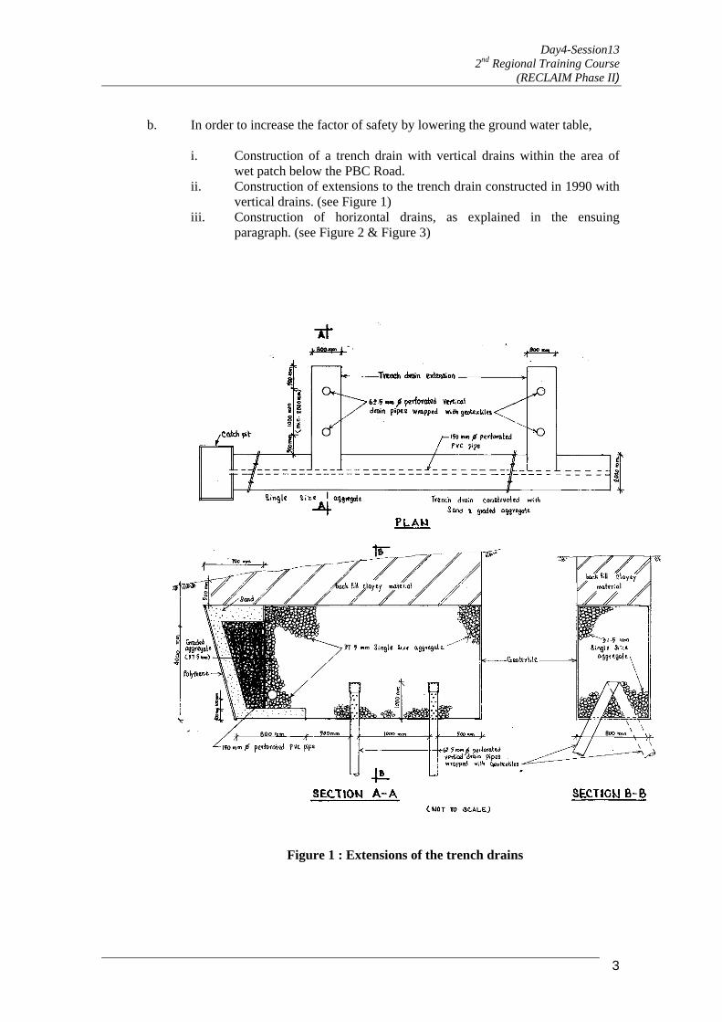
b. In order to increase the factor of safety by lowering the ground water table,
i. Construction of a trench drain with vertical drains within the area of wet patch below the PBC Road.
ii. Construction of extensions to the trench drain constructed in 1990 with vertical drains. (see Figure 1)
iii. Construction of horizontal drains, as explained in the ensuing paragraph. (see Figure 2 & Figure 3)
Figure 1 : Extensions of the trench drains
3

Day4-Session13 2nd Regional Training Course
(RECLAIM Phase II)
Figure 2 : Cross section of horizontal drain
Figure 3 : Cross section of falling horizontal drain 03 Nos. of Horizontal drains were constructed with a rising gradient of about 5o to the
horizontal above the landslide area. Due to the geographical limitations at the site, it was not possible to construct normal horizontal drains with rising gradients, near the top wet patch area above the PBC Road. Therefore making use of the artesian pressure at this area, 02 Nos. of horizontal drains were constructed with a falling gradient of about 5o to the horizontal under the PBC road. This enabled the releasing of the artesian
4

Day4-Session13 2nd Regional Training Course
(RECLAIM Phase II)
pressure to a level of 2.58m below the ground level from 1.02m above ground level during the period from 30.08.95 to 26.05.96.
After completion of the construction of these remedial measures, piezometer readings
were taken regularly and it was found that the ground water tables always remained at safer levels. The water patches disappeared completely and the area became dry after the above control measures.
2.2 Case Study 2 : Landslide at Beragala on Beragala-Haliela Road between culvert
No. 2/1 & 2/2 and between culvert No. 184/15 & 185/7 on Colombo Ratnaura-Wellawaya- Batticaloa Road (CRWB)
2.2.1 History
This landslide had taken place in 1986 and also in 1987 during the periods of heavy rain. The major cause of this landslide was the water logging within the unconsolidated colluvium. This situation was created due to the uncontrolled watering of vegetable plots, collecting water in unlined collection pits and unsatisfactory maintenance of surface drainage.
In 1987 cracks had appeared to a length of about 100m on the road A16 between culvert Nos. 2/1 and 2/3 and the road had sunk to a depth of more than 1.5m. Commencing from this event, this section of the road had been sinking by few centimeters every rainy season. (See Figure 4).
Figure 4 : Sketch showing the Beragala landslide
2.2.2 Investigations
5
Day4-Session13 2nd Regional Training Course
(RECLAIM Phase II)
6
In 1988 geotechnical investigations were carried out under the Asian Development Bank (ADB) funded second road improvement project for the RDA but the remedial measures were not taken up under the ADB project due to the lack of funds. This matter was again taken up in late 1991 and 1992 by the R&D Division of the RDA and a decision was made to carry out the remedial measures in stages. 2.2.3 Remediation measures carried out at Beragala. The following remedial measures were carried out in 1994.
a. Construction of a diversion drain to a length of about 500m from culvert Nos. 2/3 to 1/13, with a leadaway on stable rock bedding, to divert the surface run off and stream water coming into the landslide area through culvert Nos. 2/3 and 2/1. Concrete spun pipes of 1200mm dia. were used in the sliding area while the concrete open channel section was used in stable section.
b. Construction of trench drain of about 50m length between culvert Nos. 2/1 to 2/2. The purpose of this trench drain is to lower the ground water table.
c. Construction of horizontal drains into the road embankment side slopes at two elevations.
2.2.4 Subsequent road subsidence in 1997 and further remedial measures
During November 1997, very heavy rains triggered off subsequent road subsidence. In the period from 1999 to 2000, the above mentioned trench drains was extended 70m towards culvert No. 2/3 and the subsided and damaged sections of 500m diversion drain were realigned, brought to correct levels and repaired.
2.2.5 Monitoring of levels of the road and diversion drain
This monitoring has indicated no appreciable settlements of the road and the diversion drain during the period from 2000 to date.
2.3 Case Study 3 : Uthuwankanda landslide on 86thkm Colombo-Kandy (C-K) Road–Kegalle District At this site, the valley side slopes of height 20m of a widened section of the above road had collapsed in June 1990 due to unstable foundation and stream cutting at the toe, insufficient compaction and steep slopes of widened section of the embankment, coupled with seepage forces at several areas of the side slopes.
In December 1990, a method of reconstruction of excavation and removal of bad subsoil at the toe of the landslide, filling and compacting the excavated areas with suitable soil, widening the side slopes of embankment to stable slopes from 1 vertical: 1.84 to 2.7 horizontal, construction of filters at the seepage areas and protection of the toe with riprap up to 2m above the flood level of the stream and turfing above the rip rap, was proposed but later abandoned.
2.3.1 Remediation measures carried out at Uthuwankanda landslide From October 1991 to May 1992 the embankment side slopes were reconstructed by the RDA and the Road Construction & Development Company, Sri Lanka by constructing anchored tyre (discarded) retaining walls along the stream and at four levels between the toe and the road levels along with the construction of filters at the seepage areas (See Figure 5). In this work the road shoulders were widened to 3.5m along with the construction of drains leading to tyre cascades along the side slopes. This is a cost effective, labour intensive method and can be used for stabilizing earth slips and for earth retaining structures.

Day4-Session13 2nd Regional Training Course
(RECLAIM Phase II)
Figure 5 : Cross section of the anchored tyre retaining walls on 86thkm Colombo- Kandy Road
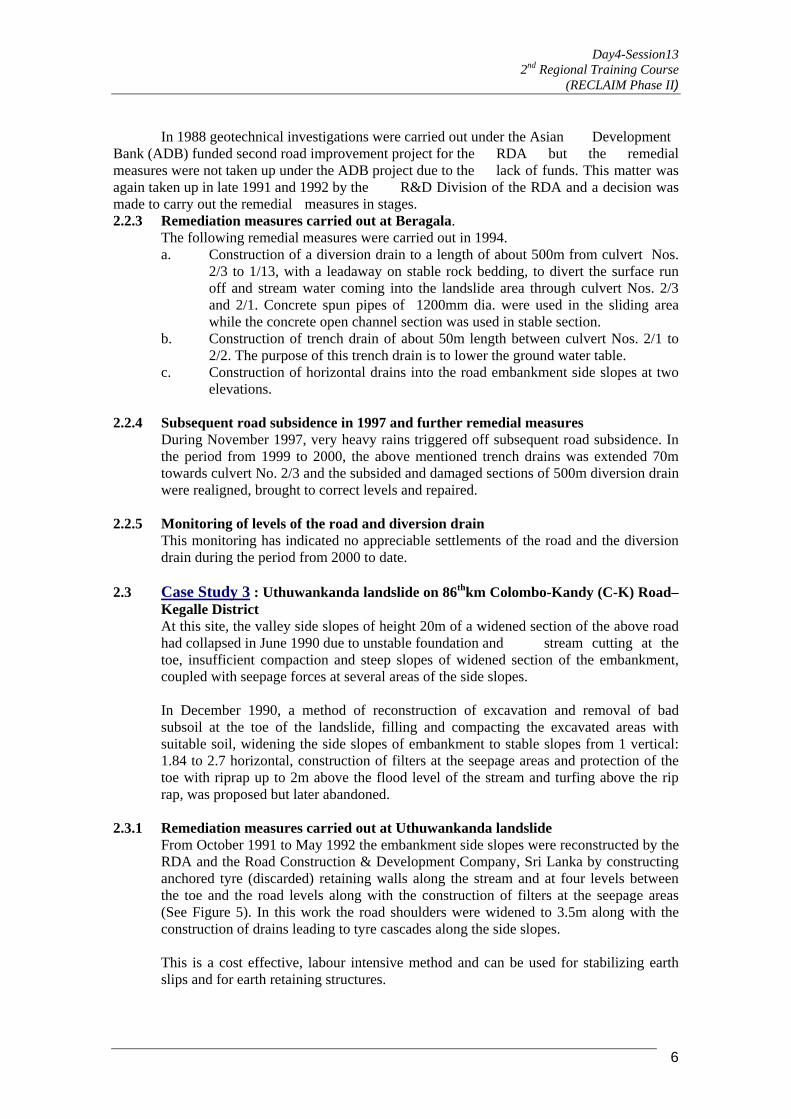
The foundation of the anchored tyre retaining structure is taken to a suitable depth in naturally stable ground or compacted and stabilized ground. The unserviceable tyres, preferably of equal size are placed on the foundation of the retaining structure along the face to interlock with each other and tied together. Preferably soil with low plastic characteristics and dry density greater than 1.6 tons/cu.m is placed inside the tyre and pushed into the vacant spaces finally filling the total space and compacting sufficiently. The space between the outer perimeter of the tyres and the excavation for the foundation is filled and sufficiently compacted. Back filling is done in the embankment and adequately compacted. A new row of tyres is placed above the ground level and tied using long lasting ropes of suitable diameter to every other tyre. The anchor tyre is placed in the stable zone (passive zone) and every other tyre in the row is tied to the anchor. The number of tyres tied to the anchor is limited to 4. Back filling is done in the embankment and adequately compacted. This procedure is repeated until the required height is reached. Figure 6 indicates the plan view of the tyre row and the anchor.
7
Day4-Session13 2nd Regional Training Course
(RECLAIM Phase II)
Proposed line of tyre retaining wall
Figure 6 : Plan view of the tyre row and the anchor 2.4 Case Study 4 : Naketiya – Koslanda landslide at Bridge No. 199/2 on Beragala– Wellawaya Road 2.4.1 History Surface cracks appeared on the ground and damages to the bridge No. 199/2 occurred
during the monsoon rains in 1988 according to the information gathered from the villagers. This was investigated by the NBRO in 1995. However in November 1997 a major landslide occurred after very heavy rainfall.
2.4.2 Investigation
The ground water regime was monitored by installing piezometers at 3 levels in 9 boreholes sunk in the landslide area. Monuments were fixed throughout the landslide area and the ground movements were monitored.
2.4.3 Remediation measures carried out at Naketiya – Koslanda landslide
(a) Landscaping and improving the surface drainage system The uneven surface has a tendency for water to get accumulated, percolate into the soil and endanger the slopes. Therefore the surface was leveled with a profile that would expeditiously drain away any storm water falling on the same. A system of surface drains was constructed to direct water towards the main stream. The deep side slopes and the bed of the main stream were made more stable and less erodible by placing boulders towards the bottom of the side slopes. Water courses at the head of the landslide area were diverted away from the landslide area. The present drainage channels & streams were cleared to ensure smooth flow of water, quickly away from the landslide area.
(b) Sealing tension cracks in the upper part of the landslide area
8
Day4-Session13 2nd Regional Training Course
(RECLAIM Phase II)
Such tension cracks were sealed against any type of water entry into the soil of the affected area.
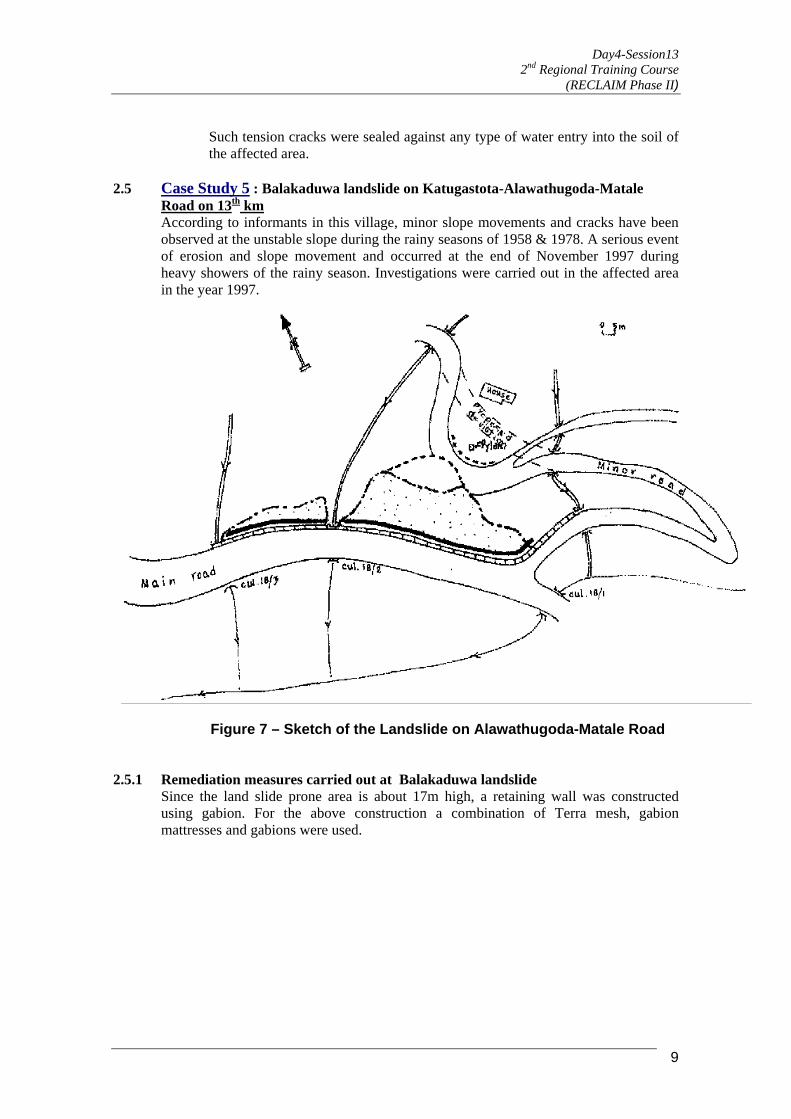
2.5 Case Study 5 : Balakaduwa landslide on Katugastota-Alawathugoda-Matale Road on 13th km
According to informants in this village, minor slope movements and cracks have been observed at the unstable slope during the rainy seasons of 1958 & 1978. A serious event of erosion and slope movement and occurred at the end of November 1997 during heavy showers of the rainy season. Investigations were carried out in the affected area in the year 1997.
Figure 7 – Sketch of the Landslide on Alawathugoda-Matale Road 2.5.1 Remediation measures carried out at Balakaduwa landslide
Since the land slide prone area is about 17m high, a retaining wall was constructed using gabion. For the above construction a combination of Terra mesh, gabion mattresses and gabions were used.
9

Day4-Session13 2nd Regional Training Course
(RECLAIM Phase II)
Gabion Construction at Balakaduwa
Also the following were carried out. a. A suitable geotextile was placed on the hill side of the gabion wall as a filter
material in order to protect the washing off of the particles of the backfill, through gabion wall.
b. Deviation of the minor road. c. As the landslide was activated by the surface runoff of a minor road, lined
surface drains were constructed diverting this water away from the landslide area.
2.6 Case Study 6 : Landslides on Gampola-Nawalapitiya and Gampola-Nuwara Eliya
Road Widening of the Gampola-Nawalapitiya Road and Gampola-Nuwaraeliya road is in
progress at present. Some of the locations where hill slopes were cut are very close to the existing residential houses.
2.6.1 Remediation measures carried out on Landslides at Gampola-Nawalapitiya and Gampola-Nuwara Eliya Road
Considering the various proposals of retaining structures such as rubble masonry retaining wall, gabion wall & soil nailing, it was found that soil nailing was the most feasible solution to eliminate the risk of slope failures at houses located on the hillside close to the road. The method of soil nailing was used to improve the factor of safety and reduce the risk involved, since this was a cost effective solution. In order to protect the side slopes shotcreting, hydroseeding and planting creepers were carried out.
10

Day4-Session13 2nd Regional Training Course
(RECLAIM Phase II)
2.7 Case Study 7 : Marangahawela Landslide On Colombo Ratnapura Wellawaya
Batticaloa Road (CRWB) between culvert No. 170/10 And 170/12 Heavy rains caused this landslide to occur in November 1997 and resulted in subsidence of the road of approximate length 50m at culvert No. 176/11 on the CRWB road. Several cracks were observed at the hill side of the road, and towards the valley side, small subsidences were observed.
2.7.1 Investigations
Geotechnical investigations along with topographical survey were carried out. 4 vertical boreholes were drilled and stand pipe piezometers were installed in the unstable area. In one borehole artesian pressure was observed. Water table reached the ground level during periods of heavy rain.
2.7.2 Remediation measures carried out at Marangahawela Landslide a. A drainage well was constructed at location of borehole where artesian pressure
was observed. b. 03 No. of horizontal drains were constructed to lower the ground water table
below the road level.
11
Day4-Session13 2nd Regional Training Course
(RECLAIM Phase II)
3.0 SUMMARY OF REMEDIATION TECHNIQUES TAKEN FOR LANDSLIDE LOCATIONS
Remediation Techniques adopted
Case Study 1
Case Study 2
Case Study 3
Case Study 4
Case Study 5
Case Study 6
Case Study 7
Landscaping X X X X Drainage a. Surface drain X X X X X X b. Trench drain X X c. Horizontal drain X X X d. Diversion drain X e. Drainage well X Retaining structure a. Tyre retaining structure X
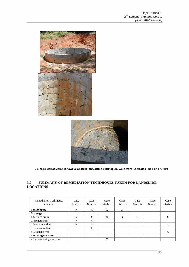
Drainage well at Marangahawela landslide on Colombo-Ratnapura-Wellawaya-Batticaloa Road on 170th km
12
Day4-Session13 2nd Regional Training Course
(RECLAIM Phase II)
13
b. Gabion walls X c. Soil nailing X Re-location X
4.0 LANDSLIDE RISK AND THEIR MITIGATION A compendium of landslides in the hill country of Sri Lanka written by Sithamparapillai
(1994) indicates many landslides which had occurred from late 1970s to the early 1990s. In addition to this paper, the other papers published in the National Symposium of landslides (1994), reported many persons killed with great loss to land and property. In addition some of these landslides have occurred due to the re-occurrence of an earlier landslide. These indicate that there is a high risk to landslides in the hill country of Sri Lanka.
The authors are of the view that if mitigation measures had been carried out prior to the
occurrence of these landslides, some of them could have been controlled to prevent such devastation. This is particularly so at sites, where the re-occurrence of landslides had taken place at the same sites, that have been left unattended.
The simplest technique of mitigation is the deviation of streams and water ways, away
from the landslide areas to stable areas. For these it will be prudent, initially to spend a reasonable amount of funds on an annual basis.
Many landslides tend to reoccur from time to time, if they are unattended. For these
works of landslide mitigation, the remediation techniques, which have been described in the previous paragraphs, could be utilized. In order to carry out such methods, another reasonable amount could be spent, annually.
In the case of such mitigation measures, it is important that the sites where such
mitigation work have been done, including the diversion of stream etc, be maintained in a manner that such measures will be effective in the future. For these also a reasonable sum of money per year could be spent.
Therefore by carrying out the above procedures, it could be possible to reduce the
landslide risk in developing countries like Sri Lanka. 5.0 CONCLUDING REMARKS
As per the records available in the Research & Development Division of the RDA and other agencies in Sri Lanka, most of the landslides affecting roads in Sri Lanka have been triggered off during or just after heavy rains. The surface and subsurface water conditions have considerably affected these landslides. To control the landslides affecting roads, one should study the surface and subsurface water regime carefully and take appropriate measures to improve such unfavourable conditions. The significant advances made in the techniques of the construction of trench drains, horizontal drains and diversion drains etc. using locally available materials, equipment and machinery will encourage local engineers to make use of these methods in the control of landslides in a developing country like Sri Lanka.

Day4-Session13 2nd Regional Training Course
(RECLAIM Phase II)
14
Such techniques carried out at appropriate time could save considerable amount of money. In the case of Naketiya landslide, the immediate reinstatement could have costed many millions of US dollars. Where as by waiting for 2 to 3 years the landslide has been considerably controlled with an expenditure of about US $70,000/= in the year 2000 by carrying out simple techniques of landscaping and stream training. As these techniques can be adopted as preventive measures well in advance at unsafe locations after detailed site investigations, it is possible to minimize the loss of lives, damages to properties and services from unfortunate occurrence of such disasters. Also this will protect the country’s economy from unexpected severe losses.
6.0 REFERENCES: 1. Road Development Authority (RDA), Battaramulla, Sri Lanka. “Geotechnical
Report (1989) Asian Development Bank Funded Second Road Improvement Project Phase – 1, Beragala Landslide”.
2. Mallawaratchie DP, Jayamanne J, Thuraisamy M and Attanayake AML (1996) Stage 1 – “Remedial Measures for Stabilizing Landslide at Beragala on Beragala-Haliela Road” Proceedings of 7th International Symposium on Landslides, Trondheim, Norway.
3. Mallawaratchie DP and Jayamanne J (1996) “Further Measures to control the landslide at Pussellawa” Proceedings of Annual Sessions of the Institution of Engineers, Sri Lanka.
4. Research & Development Division, RDA, Ratmalana, Sri Lanka (1991 to 1996) unpublished data.
5. Mallawaratchie DP, Rajapakse L and Bandara KAGS (1994) “Remedial Measures for Stabilizing Landslide at Pussellawa on Kandy-Nuwaraeliya Road – Construction aspects”. Proceedings of National Symposium on Landslides, Colombo, Sri Lanka.
6. Mallawaratchie DP (1994) “Landslides affecting National Roads in Sri Lanka. “Proceedings of National Symposium on Landslides, Colombo, Sri Lanka.
7. Sumanaratne IHD, Mallawaratchie DP and Kulathilake SAS (1997), “Stabilization of slopes by Anchored Tyre Retaining Structures”, Proceedings of the Fourteenth International Conference of Soil Mechanics and Foundation Engineering Hamburg, Germany.
8. Jayamanne J, (1997), “Note on recent work done on landslides affecting roads in Sri Lanka”, Proceedings of PIARC G2 Group International Seminar on Natural Disaster Reduction for Roads, New Delhi, India.
9. Sithambarapillai, (1994), “ A compendium of known landslides in the Hill country of Sri Lanka”. Proceedings of National Symposium on Landslides, Colombo, Sri Lanka.
10. National Building Research Organization (1994), Proceedings of National Symposium on Landslides, Colombo, Sri Lanka.
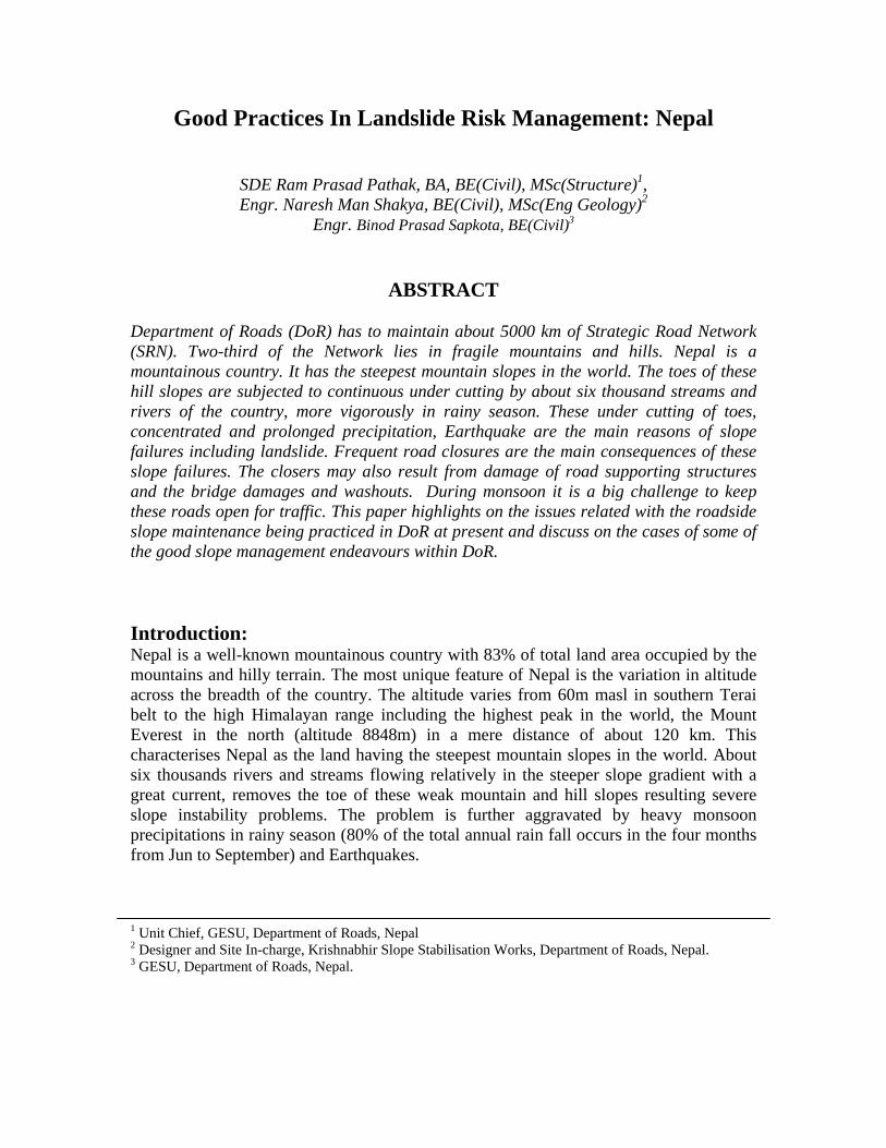
Good Practices In Landslide Risk Management: Nepal
SDE Ram Prasad Pathak, BA, BE(Civil), MSc(Structure)1, Engr. Naresh Man Shakya, BE(Civil), MSc(Eng Geology)2
Engr. Binod Prasad Sapkota, BE(Civil)3
ABSTRACT Department of Roads (DoR) has to maintain about 5000 km of Strategic Road Network (SRN). Two-third of the Network lies in fragile mountains and hills. Nepal is a mountainous country. It has the steepest mountain slopes in the world. The toes of these hill slopes are subjected to continuous under cutting by about six thousand streams and rivers of the country, more vigorously in rainy season. These under cutting of toes, concentrated and prolonged precipitation, Earthquake are the main reasons of slope failures including landslide. Frequent road closures are the main consequences of these slope failures. The closers may also result from damage of road supporting structures and the bridge damages and washouts. During monsoon it is a big challenge to keep these roads open for traffic. This paper highlights on the issues related with the roadside slope maintenance being practiced in DoR at present and discuss on the cases of some of the good slope management endeavours within DoR. Introduction: Nepal is a well-known mountainous country with 83% of total land area occupied by the mountains and hilly terrain. The most unique feature of Nepal is the variation in altitude across the breadth of the country. The altitude varies from 60m masl in southern Terai belt to the high Himalayan range including the highest peak in the world, the Mount Everest in the north (altitude 8848m) in a mere distance of about 120 km. This characterises Nepal as the land having the steepest mountain slopes in the world. About six thousands rivers and streams flowing relatively in the steeper slope gradient with a great current, removes the toe of these weak mountain and hill slopes resulting severe slope instability problems. The problem is further aggravated by heavy monsoon precipitations in rainy season (80% of the total annual rain fall occurs in the four months from Jun to September) and Earthquakes. 1 Unit Chief, GESU, Department of Roads, Nepal 2 Designer and Site In-charge, Krishnabhir Slope Stabilisation Works, Department of Roads, Nepal. 3 GESU, Department of Roads, Nepal.

The mountain-building processes in Nepal have resulted in predominantly east-west trending ridges and river valleys, but with the occasional north-south trending river courses breaking through the ridges, carrying huge volume of run-off form the high mountains at the north to the southern terai belt. Most of the strategic road networks of hill and mountain areas of Nepal are aligned along these linear river valleys. These linear river valleys offer simplicity to the road designers but at the same time these also bring with them a multitude of slope stability problems. Construction and maintenance of mountainous Road Network in Nepal, is no doubt a greatest challenge to highway engineers. Since, construction of first motorable road in Kathmandu valley in 1924, the Department of Roads has contributed directly or indirectly in construction of about 16,000 kms of road network with assistance from bi-lateral and multi-lateral agencies. The issues of environmental and geotechnical aspects were not addressed until the construction of Dharan-Dhankuta and Lamosangu-Giri Roads in late seventies and early eighties. Since then, the Department of Roads is besieged by advice on slope stabilisation issues. The slope stabilisation issues have been covered (some of them are very costly and some are of low cost type) by numerous international and local initiatives, based on the experience of different donors and consultants. These can lead to widespread confusion as to the best approach to be used particularly in maintaining and rehabilitating roadside slopes. This paper intends to highlight on the issues related with the roadside slope maintenance being practiced in DoR at present and discuss on the cases of some of the good slope management endeavours within DoR. Roadside Slope Maintenance Issues: Most of the roads have degraded much faster than they should have done while road pavement and side drains may be near perfect. The reason for this is usually that the slopes have not stabilised or protected adequately. Some of the major issues are listed hereunder:
• It has been a tendency to provide a big single structure such as retaining wall, check dam etc. without giving due consideration to the weak and unfavourable founding and slope conditions to stabilise unstable slopes. The provision of stabilising measures is often confined to the vicinity of carriageway only. This often results in treating for example, debris trails in stead of stabilising the unstable slopes located well above the carriageway. Consequently, the stabilising structures in such debris trails fail.
• There is a tendency to design retaining structures by using thumb rule like Base
Width of the Foundation of Walls (no matter whether it is a road retaining wall or breast walls, with or without sloping backfill) equals to 0.6 times height of the wall. This approach however, satisfies many conditions but could prove to be detrimental where such wall is designed to stabilise sloping backfill in excess of 25 degrees or moving slope.

• There is a concept among the DoR engineers that higher volume of structures means better stability of the slopes. This concept sometimes proves to be suicidal particularly when massive structures are placed over the active slip plane besides almost all DoR engineers having knowledge of requirement to locate such structures below the slip plane. The reason behind this is that limited engineers have adequate geo-technical knowledge and experience to explore and identify the slip planes.
• Geo-technical investigation is still perceived as wastage of time and money. The
minimum that can be spent in the geo-technical investigation is the best sort of attitude reveals. This makes a short term saving on time and money but the financial and time lost by over or under designing the structures/measures in the long run.
• No comprehensive guidelines on the level of geo-technical investigations
required for dealing with the geo-technical related problems, design guidelines including detailed drawings of type designs of various geo-technical structures are available so far. However, the theories provided in the Road Note 16, Guide to Road Slope Protection and other literatures have covered various aspects of designs but still these do not provide required details of such drawings which may be one of the major reasons in not being able to provide appropriate designs by the DoR engineers.
• The slope stabilisation and other geo-technical issues have been covered (some
of them are very costly and some are of low cost type) by numerous international and local initiatives, based on the experience of different donors and consultants. These can lead to widespread confusion as to the best approach to be used particularly in maintaining and rehabilitating roadside slopes.
• The importance of integrating civil engineering structures with bio-engineering
structures to give the best results economically, technically and environmentally in slope stabilisations has not been well realised by the DoR engineers.
• Lack of institutional lesson-learning. An example of the lack of lesson-learning
in DoR is briefed here under: Concrete bound retaining wall was constructed at steep slopes of deep colluvium at Karkichhap area of Dharan-Dhankuta Road in the estern Nepal. The walls were founded on unconsolidated colluvium. In the earthquake of August 1988, movement in the colluvium caused a complete failure of the upper section of road as the walls rolled down the slope, taking the road with them. It was considered necessary to replace these rigid structures with something flexible and a single 300 m long gabion retaining wall was constructed to support the upper road section. This wall is functioning satisfactorily to date.
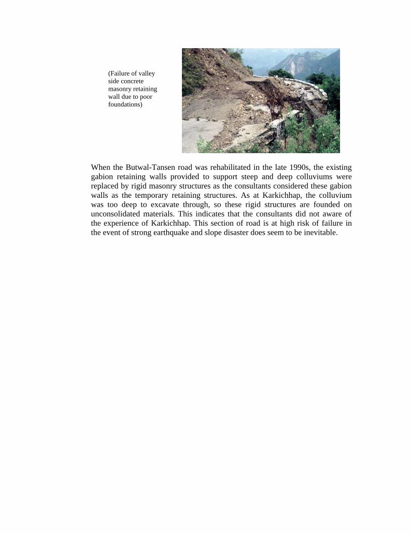
(Failure of valley side concrete masonry retaining wall due to poor foundations)
When the Butwal-Tansen road was rehabilitated in the late 1990s, the existing gabion retaining walls provided to support steep and deep colluviums were replaced by rigid masonry structures as the consultants considered these gabion walls as the temporary retaining structures. As at Karkichhap, the colluvium was too deep to excavate through, so these rigid structures are founded on unconsolidated materials. This indicates that the consultants did not aware of the experience of Karkichhap. This section of road is at high risk of failure in the event of strong earthquake and slope disaster does seem to be inevitable.

Good Practices of Roadside Support Maintenance: Despite all such issues, the Department of Roads' engineers have successfully stabilised some of the worst and massive slope stability problems. Stabilisations of these slopes were great challenge to any international experts as well. A brief description of two of such examples are provided hereunder: Case 1: Stabilisation of the Baglung Loop: The picture in the left in the subsequent page is of the ascent from the Kali Gandaki to Baglung bazaar in 1994. The road construction project had paid no attention to slope stability. Debris from both sections of road was thrown down the slope, causing large gullies to form and creating a number of mass movements. The lower section was damaged by debris blocking the side drain and falling on to the carriageway. It was also undermined by erosion from the unprotected drain discharge points. The Division Roads Office responsible for maintenance of this road carried out slope stabilisation works on this slope with judicious use of gabion drainage structures and extensive bio-engineering measures. The Division Road Office was well supported by then Geo-environmental Unit, which a specialist unit (in bio-engineering, geo-technical engineering and Environmental engineering) at the head office of Department of Roads. At low cost DoR had undertaken this slope stabilisation on a very large scale and to a high standard.
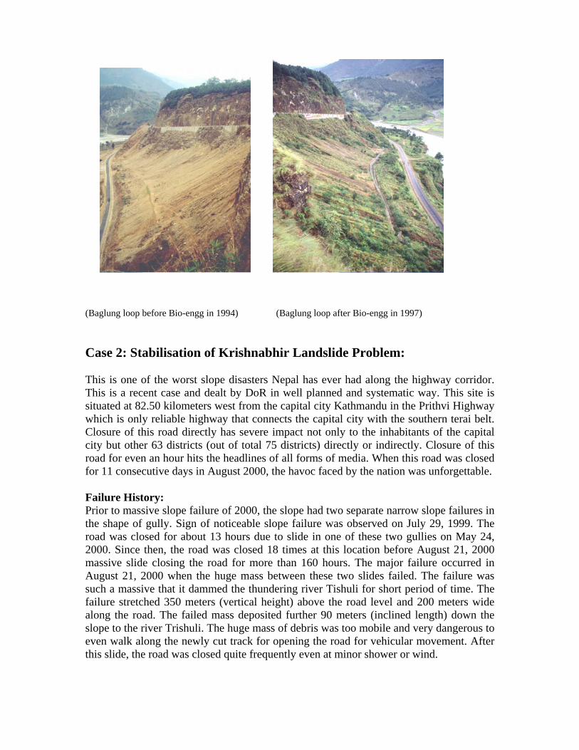
(Baglung loop before Bio-engg in 1994) (Baglung loop after Bio-engg in 1997) Case 2: Stabilisation of Krishnabhir Landslide Problem: This is one of the worst slope disasters Nepal has ever had along the highway corridor. This is a recent case and dealt by DoR in well planned and systematic way. This site is situated at 82.50 kilometers west from the capital city Kathmandu in the Prithvi Highway which is only reliable highway that connects the capital city with the southern terai belt. Closure of this road directly has severe impact not only to the inhabitants of the capital city but other 63 districts (out of total 75 districts) directly or indirectly. Closure of this road for even an hour hits the headlines of all forms of media. When this road was closed for 11 consecutive days in August 2000, the havoc faced by the nation was unforgettable. Failure History: Prior to massive slope failure of 2000, the slope had two separate narrow slope failures in the shape of gully. Sign of noticeable slope failure was observed on July 29, 1999. The road was closed for about 13 hours due to slide in one of these two gullies on May 24, 2000. Since then, the road was closed 18 times at this location before August 21, 2000 massive slide closing the road for more than 160 hours. The major failure occurred in August 21, 2000 when the huge mass between these two slides failed. The failure was such a massive that it dammed the thundering river Tishuli for short period of time. The failure stretched 350 meters (vertical height) above the road level and 200 meters wide along the road. The failed mass deposited further 90 meters (inclined length) down the slope to the river Trishuli. The huge mass of debris was too mobile and very dangerous to even walk along the newly cut track for opening the road for vehicular movement. After this slide, the road was closed quite frequently even at minor shower or wind.

(Failure on August 21, 2000) Geo-technical Investigations: The huge amount of debris made it very difficult to identify the failure reasons and to find out the failure extents through ground investigations. The debris was so mobile that it was impossible to carry out any short of drilling operations for geo-technical investigations. So, a contour map was prepared to find out at least the failure dimension and set a base map for monitoring of debris removal in the later period. Since, ground investigations through drilling work is not possible as already stated; an Electrical Resistivity Survey was carried out in 2000 to explore the slip plane and probable depth of the sound bed rock. It was observed from this study that there was no sound rock available even at 20 meters depth from the existing debris surface. The slip plane was identified at 10 meters depth from the ground surface. Further, it was also identified that there was two separate slope failures with one situated above and other below the road level which were coincidently occurred at the same location. These findings guided DoR to carry out the mitigating measures in stages.
(Resistivity Tomograms along the center line of the slide)
After the 2001 and 2002 monsoons, contour maps were again prepared to monitor the volume of debris removal and these maps were later used as base map for engineering geological mapping.
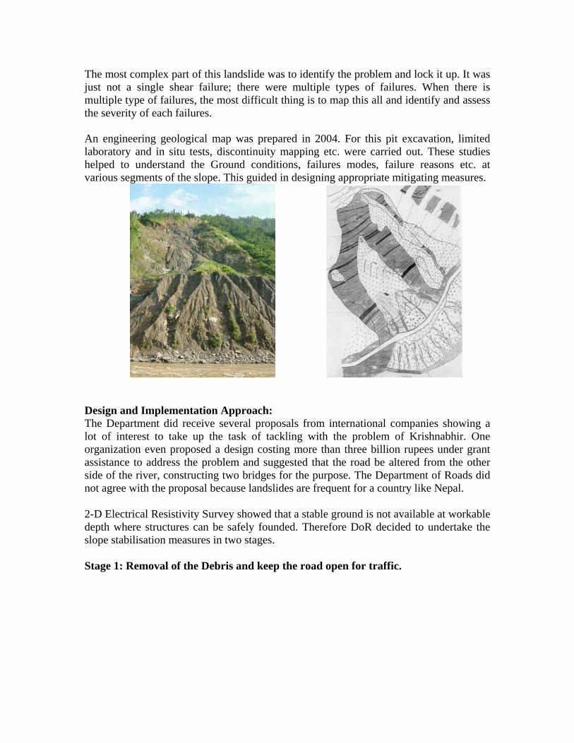
The most complex part of this landslide was to identify the problem and lock it up. It was just not a single shear failure; there were multiple types of failures. When there is multiple type of failures, the most difficult thing is to map this all and identify and assess the severity of each failures. An engineering geological map was prepared in 2004. For this pit excavation, limited laboratory and in situ tests, discontinuity mapping etc. were carried out. These studies helped to understand the Ground conditions, failures modes, failure reasons etc. at various segments of the slope. This guided in designing appropriate mitigating measures.
Design and Implementation Approach: The Department did receive several proposals from international companies showing a lot of interest to take up the task of tackling with the problem of Krishnabhir. One organization even proposed a design costing more than three billion rupees under grant assistance to address the problem and suggested that the road be altered from the other side of the river, constructing two bridges for the purpose. The Department of Roads did not agree with the proposal because landslides are frequent for a country like Nepal. 2-D Electrical Resistivity Survey showed that a stable ground is not available at workable depth where structures can be safely founded. Therefore DoR decided to undertake the slope stabilisation measures in two stages. Stage 1: Removal of the Debris and keep the road open for traffic.

Since, there was no point whatsoever in building any structures until the debris volume reduced greatly. Equally important was that there was no point in retaining the huge debris on the slope. Every time there was debris fall/flow on the road surface, the debris was cleared by two bulldozers that were at standby on either ends of the slide in 2000 and 2001 under this stage.
With much of the debris cleared in two years, the gabion breast wall and some other structures were constructed at the hill and valley sides in 2002. Road closure reduced slightly but the effectiveness of the structures did not last for long. Valley side structures and sand bag check dams at upslope gullies could not withstand the monsoon of 2002. Stage 2: Initiation of Permanent Solution: Stabilization efforts of Krishnabhir took a serious turn after the Department of Roads decided to initiate a permanent solution to the problem with its available resources in 2003. The mitigation design especially concentrated on understanding the problem correctly, avoiding the use of sophisticated technologies demanding high skilled manpower and modern equipment as far as possible and making the most of low cost technology with the combination of civil and bio-engineering structures wherever possible. Based on the geo-physical study, topographical survey, limited lab and in situ tests, a detailed mitigating plan was worked out to stabilize the slope above the road level. Stabilisation of slope above the road level constitutes the first phase of stage 2 mitigation plan since, the road closure can be minimised by stabilising/managing this upper slope. Water management did appear to be the main problem, so, uncontrolled flow of run off from the crown which is about 350 meters high (vertically) from the road level, diverted into the three naturally created gullies. Catch drains were provided beyond the crown area of the slide to prevent the water gushing down into the landslide. When the water is diverted into the natural gully, it has a severe damaging effect and it is important to dissipate the energy to reduce its damaging effect, so, series of concrete and gabion check dams, cascade drains etc. were designed and constructed along these gullies to dissipate run off energy. Steeply inclined pipe culverts at each of these gullies were provided to safely discharge water and debris under the road preventing blocking of the road by these flowing debris.
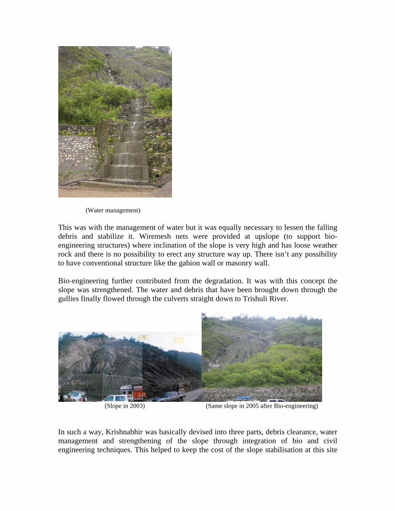
(Water management) This was with the management of water but it was equally necessary to lessen the falling debris and stabilize it. Wiremesh nets were provided at upslope (to support bio-engineering structures) where inclination of the slope is very high and has loose weather rock and there is no possibility to erect any structure way up. There isn’t any possibility to have conventional structure like the gabion wall or masonry wall. Bio-engineering further contributed from the degradation. It was with this concept the slope was strengthened. The water and debris that have been brought down through the gullies finally flowed through the culverts straight down to Trishuli River.
(Slope in 2003) (Same slope in 2005 after Bio-engineering) In such a way, Krishnabhir was basically devised into three parts, debris clearance, water management and strengthening of the slope through integration of bio and civil engineering techniques. This helped to keep the cost of the slope stabilisation at this site

extra-ordinarily low. The total cost incurred was only 50 million Nepalese Rupees which is less than two percent cost to the proposal offered by the foreign consultants. The design and implementation were continuously monitored by the division staffs, Director General, Secretary of the Ministry and other senior staffs of the department. This helped in identification of any problems and solution for the rectification of such problems. Right from the investigations to implementation, the design approach, drawings, the field conditions at various stages of the implementation etc. were documented and shared with other departmental staffs to disseminate the lesson learning. Recently, a documentary has been released as part of documentation of lesson learned and knowledge dissemination. Conclusions : In light of the experiences of above case studies, it can be concluded that : * Careful design of geo-technical investigations to assess the ground conditions,
failure mechanisms and reasons, failure scenario of the site etc. is essential to deal with slope stabilisation works. Appropriate techniques of investigation shall be designed depending upon the specific condition of the site.
* Design shall be based on clear understanding of the ground conditions evaluated by geo-technical investigations. Due consideration shall be paid to constraints of the implementing agency for example, technical capability, financial resources etc. while designing of the mitigating measures. Integration of bio-engineering with civil engineering structures has been proved to be very useful technique financially and environmentally.
* Monitoring from the operational level, managerial level and policy makers level (for complex problems) is essential for lifting performance level to a greater height.
* Recording of lesson learned and knowledge disseminations no doubt, will help in the maintaining the consistency in the performance and help in reducing the chances of committing mistakes repeatedly, hence, shall be made integral part of all slope stabilisation works projects.
References: ADHIKARI SR, SHAKYA NM., (2002). "Challenges to Hill Road Constructions in
Nepal", International Seminar on Mountain Hazards Research & Risk Minimisation, Scott Wilson Kirkpatrick & Co. Ltd., Kathmandu, Nepal.
HOWELL J., (2002). "Study of Institutional Change in the Department of Roads and
Specific Environmental Issues", Department of Roads, Nepal. TRL (1997), "Principles of low cost road engineering in mountainous regions", Overseas
Road Note 16, Overseas Centre, Transport Road Research Laboratory. SHAKYA NM., (2006). "An Overview of Slope Disaster Management at Krishnabhir", REGMI SK., SITAULA TP (2003). "Krishnabhir Slide: A Case Study", International
Seminar on Sustainable Slope Risk Management for Roads, organised jointly by Department of Roads (Nepal) and Permanent International Association for Road Congress (PIARC).
"Roadside Geotechnical Problems: A Practical Guide to their Solution", (2006). A DoR
publication under RMDP, Institutional Strengthening Componet, Nepal. "Guide to Road Slope Protection Works" (2003). A DoR publication, Nepal.

Day4-Session15 2nd Regional Training Course
(RECLAIM Phase II)
1
Landslide Hazard Mitigation Strategy in Indonesia
Case Study: :Landslide Induced by an Earthquake in Indonesia
Dr. Surono [email protected]
Center for Volcanology and Geological Hazard Mitigations (CVGHM)
Jl. Diponegoro 57 Bandung 40122, Indonesia Phone : (62-22) 7271402, 7272604, Facsimile : (62-22) 720 2761
Abstract
Indonesia is located by interacted of three big plate in the world are : Indian – Australia, Eurasia and Pacific. The consequence this condition is shape subduction zone, active fault, volcanoes belt and steeply topography. If located on the sea, the subduction zone and active fault as a source of earthquake, in certain scale possible generates tsunami. The shape of volcanoes belt cause of 129 active volcanoes and potentially to make disaster if eruption. The steeply topography and height rain fall are potentially causes landslides disaster and sometimes followed by debris flow. The earthquake caused by active fault in the land can cause landslide, ground fracture and liquefaction. The ground fracture if located on the steeply topography is potentially developed as landslide if trigger by highly rainfall. Earthquake on December 18, 2006, magnitude 5,8 Mw, depth 17 km, in Mandailing Natal Regency, North Sumatera Province caused by movement of the Great Sumatera active fault. This earthquake cause landslide, 4 peoples died and 109 housing are damages, also shape of ground fracture on the middle of slope. Cause of height intensity rainfall, this fracture has developed as a great landslide and 34 peoples died and 17 housing are destroyed and covered landslide material. The second example is the earthquake on January 24, 2005, magnitude 6,2 Mw, depth 30 km in Palu, Central Sulawesi. This earthquake has caused great landslide and covered road between Palu and District of Palolo along ± 3 km. This earthquake is caused by movement Palu – Koro active fault. The other example is earthquake on March 14, 2006, magnitude 6,7 Mw, depth 30 km, in Buru Island, Maluku Province. This earthquake caused by active fault on the land and estimated occured landslide on the sea floor, and generated tsunami with run up ± 40 cm and attached along ± 80 m from shoreline. During landslide hazard occurrence which out of local government service, CVGHM dispatching a “Quick Response Team” to the hazard location to conduct an investigations and to give technical recommendation to the local government. Another actions for landslide mitigation which have been done by CVGHM is communicated by sending letter of landslide hazard warning every early rain season to the Chief of District which mentioning the region that potentially to landslide, community preparadness are built by counselling and socialization, to give information concerning landslide susceptibility zone along Java Island main road, and also disseminating overlying maps of landslide hazard susceptibility region and rainfall forecast in the region.

Day4-Session15 2nd Regional Training Course
(RECLAIM Phase II)
2
1. Background
Indonesia lies on the triple junction of three major active plates are Indian – Australia Plate
that movement to the north with velocity 7 cm/ year, Eurasia Plate that relatively stable and Pacific
Plate that movement to the west with velocity 5 cm/ year. The consequence, in this region found
active volcano, earthquake source zones and steeply topography. Indonesia has 129 active
volcanoes. This situation makes Indonesia to be vulnerable to volcanic eruptions,
earthquake/tsunami occurrence and in some places susceptible to landslide. These hazards
causing lost of life, homeless, damaging environment, damaging life and living of people
due to geologic activity called geologic hazards to differentiate with other hazards such as
social, biologic hazards and technologic hazards.
2. GEOLOGIC HAZARDS MITIGATION STRATEGY
Geologic hazards mitigation programs for Ministry of Energy and Mineral Resources is a
part of government responsibility for people saving to the threat of earth disaster (as a basic
human right) in all over Indonesia region and must have done by the Directorate of
Volcanology and Geologic Hazard Mitigations (DVGHM).
Geologic hazard mitigations paradigm should be looked that geology dynamics (volcanic
eruptions, landslides, earthquake) as a phenomenon that could not be separated between
people living with their environment and not always be a disaster. This paradigm conflicting
highly susceptibility factor of the occurrence of the dynamic and anticipation of people if
these hazards really happen in their environment. So the mitigation strategy is focused to the
series of activity of mapping of sustainable area, emergency action, monitoring and
socialization of mitigation activity results, with priority scale of institutional resources
involving local people and local government (as the subject). The priority of geologic
hazard mitigations is in the highly susceptible destructive geology dynamics, the area with
dense populations and in the area which vital and strategic is constructed (economically and
service).
The objective of earth disaster mitigation is to minimize up to elimination of casualties also
to give security to the people to reach their prosperous from the threat of earth disaster.

Day4-Session15 2nd Regional Training Course
(RECLAIM Phase II)
3
3. LANDSLIDES
Landslides are often occurred in Indonesia, the region that highly counts on this is West
Java Province due to geologic conditions, man made and or mix of both.
Monitoring
Monitoring is focused on the region that economically and service strategic and vital.
Monitoring is to measure the rate of movement of landslide using Global Positioning
System (GPS). This measurement is a joint working with Department of Geodesy, ITB,
located between Bandung - Jakarta roadway at Ciloto, Megamendung and Cipatat, between
Bandung – Yogyakarta roadway at Wangon and Lumbir and between Bandung – Cirebon
roadway at Tomo area. This monitoring is to measure landslide rate of movement in certain
time, if the rate of movement passing the threshold, as soon as possible informed to the local
government to do some needed effort to minimize the effect that probably occurred.
Landslide Susceptibility Zone Mapping
The objective of this effort is to determine landslide susceptibility level in particular area
with parameter used are geologic conditions (type and characteristic of rocks), slope,
earth/rock mechanics, land use, surface water condition, frequency of landslide occurrence,
fault and joint, seismicity and yearly rain fall volume, processed by a software.
Landslide Susceptibility Zones divided into four zones, as:
Very low susceptibility zone: a zone with very rare or almost never have landslide
experience, either old or new landslide, except in a limited area on the river cliff.
Low susceptibility zone: a zone with rarely landslide, if there is no disturbance on the
slope. Possibly a minor landslide along river cliff.
Medium susceptibility zone: a zone with landslide occurrence prominently on the region
that bordered with river valley, slope and steep hill, road slope or if the slope has a
disturbance. Old landslide can be reactivated by high volume rainfall.
High susceptibility zone: a zone with often landslide occurrences, old and new landslide
still active due to high volume rainfall and high erosion activity.
Day4-Session15 2nd Regional Training Course
(RECLAIM Phase II)
4
PVGHM has a competency to do landslide susceptibility zone mapping with the scale of
1: 250.000 and 1: 100.000. These maps can be used by local government as a database to
make a more detail map or as a consideration for Regional and Land use Planning.
Appropriate with Minister of Interior Declaration number 131/2003 concerning Manual of
Disaster and Refugees Management that each local government should have disaster
susceptibility maps, PVGHM arranging Indonesian National Standard (INS) about
Landslide Susceptibility Zone Mapping Procedure. The objective of the INS is that
competent party can do Landslide Susceptibility Mapping in the right way.
The priority of this mapping is on the dense populated area, the area with vital and strategic
facility with often landslides occurrences. Java Island is already mapped, some places
outside Java was selected base on priority scale, technically and socio-economically
reasons.
Emergency Respond
If landslides occurred in an area that released by media nationally or regionally and could
not handled by local government, PVGHM do an emergency respond. The action of this
emergency responds are to measure the dimension of landslide, investigating geologic
conditions, surface water condition and geophysical measurement. Part of emergency
respond results are landslide mechanism up to management procedure. Emergency respond
report made very quickly (often done in the field), socialized directly to the local people
affected by landslide and to the local government for disaster management, technical
recommendation also included on the report. If the landslide location technically not
suitable for settlement, PVGHM can assist local government to find a new save location for
resettlement.
Notes
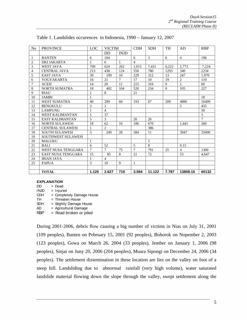
The following table shows that most often landslide region is West Java Province,
meanwhile the victim is only competed by North Sumatra Province due to the casualties of
Flood of Bahorok river causing 150 people killed, like in Nias Island as well.
Day4-Session15 2nd Regional Training Course
(RECLAIM Phase II)
5
Table 1. Landslides occurences in Indonesia, 1990 – January 12, 2007
No PROVINCE LOC VICTIM DD INJD
CDH SDH TH AD RBP
1 BANTEN 6 104 6 3 6 4 196 2 DKI JAKARTA 1 6 1 4 3 WEST JAVA 709 624 262 1,015 7,431 6,222 2,773 7,224 4 CENTRAL JAVA 213 438 124 550 780 1293 340 2234 5 EAST JAVA 39 199 10 229 312 13 247 1,970 6 YOGYAKARTA 16 21 7 17 10 19 2 110 7 ACEH 14 20 11 215 316 0 1. 60 8 NORTH SUMATRA 18 402 104 520 234 0 105 227 9 RIAU 1 8 21 10 JAMBI 1 18 11 WEST SUMATRA 40 289 60 193 67 209 4886 16409 12 BENGKULU 3 1 5 435 13 LAMPUNG 1 4 30 14 WEST KALIMANTAN 1 37 5 15 EAST KALIMANTAN 5 3 20 26 7 16 NORTH SULAWESI 18 62 16 186 670 1,441 260 17 CENTRAL SULAWESI 1 2 386 18 SOUTH SULAWESI 5 249 28 584 11 3947 25000 19 SOUTHWEST SULAWESI 20 MALUKU 1 5 21 BALI 6 52 5 8 0.15 22 WEST NUSA TENGGARA 7 7 75 7 791 25 4 1300 23 EAST NUSA TENGGARA 15 85 8 21 72 53 4,647 24 IRIAN JAYA 1 4 25 PAPUA 3 10 9 1 TOTAL 1.125 2.627 715 3.594 11.122 7.787 13808.15 60132
EXPLANATION DD = Dead INJD = Injured CDH = Completely Damage House TH = Threaten House SDH = Slightly Damage House AD = Agricultural Damage RBP = Road broken or piled
During 2001-2006, debris flow causing a big number of victims in Nias on July 31, 2001
(109 peoples), Banten on Pebruary 15, 2001 (92 peoples), Bohorok on Nopember 2, 2003
(123 peoples), Gowa on March 26, 2004 (33 peoples), Jember on January 1, 2006 (98
peoples), Sinjai on Juny 20, 2006 (204 peoples), Muara Sipongi on December 24, 2006 (34
peoples). The settlement dissemination in these location are lies on the valley on foot of a
steep hill. Landsliding due to abnormal rainfall (very high volume), water saturated
landslide material flowing down the slope through the valley, swept settlement along the
Day4-Session15 2nd Regional Training Course
(RECLAIM Phase II)
6
valley. Because the landslide occurred during the night which the people are slept in their
house causing victim in a large number.
Central to the Southern part West Java Province are susceptible to the landslide including
Regency of: Ciamis, Tasikmalaya, garut, Bandung, Sukabumi, Bogor and Cianjur. High
susceptibility level in this region is due to thickness of weathered rock layers that composed
by young volcanic, high permeability rocks on the impermeable basement rock on the
slightly slope up to steep slope hill and also land use that not pay attention to the
environmental conditions. Join cooperation between PVGHM and West Java Province
government (Dinas Pertambangan dan Energi, DISTAMBEN) in 2003, conducted landslide
susceptibility zone mapping in 12 landslide susceptible districts. The results was already
disseminated to each district and socializing by both institution in each Regional
Coordination Board (known as Bakorwil) in West Java Province.
Landslide early warning system is run in every beginning of rainy season by sending letter
to the government of Province/District/City in Indonesia including leaflet and poster about
procedure of mitigation and disaster management with highlight to Sub District that very
high susceptible to landslide. Cooperation with BMG (Indonesian Geophysics and
Meteorological Agency) in 2004 to publish landslide probability map on a region based on
overlaying maps of medium to short period (3 and 6 monthly) rainfall probability map and
landslide susceptibility zone map, which hope that PVGHM can informed landslide early
warning more detail and accurate with the results approaching high level of true conditions.
4. LANDSLIDE INDUCED BY AN EARTHQUAKE IN INDONESIA
The earthquake that caused by active fault on the land can cause landslide, ground fracture
and liquefaction. The ground fracture that located on the steeply topography is potentially
developed as landslide if trigger by highly rainfall. The example that earthquake induced
landslide is earthquake that occurrence on December 18, 2006, magnitude 5,8 Mw, depth
17 km, in Mandailing Natal Regency, North Sumatera Province. This earthquake caused by
movement of the Great Sumatera active fault. Epicenter is located on the land and distance
± 34 km southeast Penyabungan City (district city). Geologically composed by Pra Tertiary

Day4-Session15 2nd Regional Training Course
(RECLAIM Phase II)
and Tertiary rock with characteristics: weathered, unconsolidated and formed of steeply
topography, so it will potentially to landslide if shaking by earthquake.
This earthquake cause landslide, 4 peoples are died and 109 housing are damaged, and
shape of ground fracture on the middle of slope. This landslide make road of Pasaman
Regency (West Sumatera) to Mandailing Natal (North Sumatera) is covered by landslide.
Cause of height intensity rain fall, this fracture has developed as a great landslide and 34
peoples are died, 17 housing are destroyed and covered by landslide material.
Figure 1. Earthquake on on December 18, 2006. In this location, 4 peoples are died by
landslide.
Figure 2. Earthquake induced landslide,
covered road of Pasaman to Mandailing Natal.
The second example is the earthquake on January 24, 2005, magnitude 6,2 Mw, depth 30
km in Palu, Central Sulawesi that caused by movement Palu – Koro active fault. This
earthquake has caused great landslide and covered road between Palu to District of Palolo
along ± 3 km, ground fracture in the aluvial not on the middle of slope.
Figure 3. Landslide induced by earthquake on
Figure 4. Ground fracturing by earthquake on
7

Day4-Session15 2nd Regional Training Course
(RECLAIM Phase II)
January 24, 2005 in Central Sulawesi. January 24, 2005 in Central Sulawesi.
The other example is earthquake on March 14, 2006, magnitude 6,7 Mw, depth 30 km, in
Buru Island, Maluku Province. This earthquake caused by active fault on the land. The
result from Marine Geology Development Center show that the topography of eastern Buru
Island is very steeply. We estimated that the earthquake caused landslide on the sea floor,
and generated tsunami with run up ± 40 cm and attached along ± 80 m from shore line. The
building that collapse in this area not by tsunami, but by earthquake shaking.
Figure 5. Collapse of housing in Buru Island by earthquake on March 14, 2006 not by tsunami.
Figure 6. The height of runnup by locally tsunami about 40 cm in Buru Island.
5. DISCUSSION AND CONCLUSION
Geological hazard mitigations by PVGHM is run pre, during and post disaster. Pre disaster
is focused on monitoring, mapping, investigation, early warning system and socialization.
During disaster, if local government has a handicap to handle, PVGHM action programs are
dispatching quick respond team to the disaster area to give disaster management technical
recommendation, to give action suggestion including route and place for refugees and
together with local government staff socializing procedure of self saving and disaster
management. Post disaster, if emergency respond team declare that location technically not
suitable for settlement, PVGHM can assist local government to find a new save location for
resettlement.
Landslide still causing casualties and refugees are due to:
8

Day4-Session15 2nd Regional Training Course
(RECLAIM Phase II)
9
• Settlement dissemination and economic activity develop horizontal, that make a lot of
settlement and economic activity ‘unfortunately’ lies on landslide and earthquake
vulnerable.
• Building construction not following characteristic and dynamic of nature.
• There are a large number of settlement and economic activity in the medium to high
landslide susceptible.
• Disaster early education is still not running, causing a lot of people who life in the
disaster area but could not recognize characteristic of disaster susceptible area and also
not recognize the procedure of self saving and procedure of management.
• Lack of disaster ordinance that manage people safety to the disaster correlated with
regional development and clearly define of acting and responsibility of each institution,
that impressed in every disaster, busy to find who is going to be blame on.
The earthquake is caused by active fault movement on the land, potentially followed by
liquefaction, ground fracture also landslide on the area with steeply topography. If located
of ground fracture on the middle slope, potentially developed as a flash flooding such of
earthquake occurrence on December 18, 2006 in North Sumatera.

Day4-Session17 2nd Regional Training Course
(RECLAIM Phase II)
Landslides in Nepal and their Prevention by Bio-Engineering
Engr. Deo Raj Pokharel Department of Water Induced Disaster Prevention (DWIPD), Nepal
Introduction Nepal being a Land Locked Country between India and China which are the two large countries of south East Asia. It is extending from 26º 22'N to 30º27'N latitude and 80º41'E to 88º12'E longitude , covering an area 147181sq.km.Very rugged topography, variable climatic conditions, complex geological structures, active tectonic process and periodic seismic activities are the major physical features of Nepal. Its elevation varies from 60 m at Terai range(Jhapa) to 8848m at Mt. EVEREST(Highest pick of the world) from AMSL within a short distance of 90 to 120 km. as Shown in the fig.
Widthwise profile of Nepal
Ecologically, it is divided in to five physiographic regions comprising of í) Himalayas, ii) High Mountains, iii) Middle Mountains, iv) Siwaliks and v) Terai plain.
Politically, this country is divided into 75- districts,14 -Zones and 5 -Development Regions. Again a district is divided into Municipalities, Village Development Committees (VDCs) which are further divided into wards. These are the grass root level development organizations and the local level Government too .
1
Day4-Session17 2nd Regional Training Course
(RECLAIM Phase II)
2
District Development Committee (DDC) is the main responsible body for the development activities and the District Administration office chief (CDO) maintains the Law and Order throughout the district. Hydrology and Meteorological situations. Average annual precipitation of the country is about 1600 mm. and the variation of average annual rainfall ranges from about 300 mm. in dry rain shadow area to more than 5000 mm. in wet regions like Lumle of Kaski district. Similarly, it is extremities in temperature variations. The Himalayas have all the year round temperature below freezing point whereas at the southern part (Terai) summer temperature soars above 40ºc. Population of the country is above 23.5 million comprising of various ethnic groups with different culture and socio-economic status having a population growth rate of 2.21% per annum whereas Its GDP rate is 2.1% only Water Induced Disaster(WID) in Nepal. From the Geo-morphological setting of Nepal and constant tectonic action of varying degrees, together with varied intensity of climatic conditions has adverse effect on the stability of Earth's surface and River Courses. Similarly, the physiography of earth is changing day by day due to the tectonic and Universal Planetary action. Among these, the Himalaya region and some pockets of Oceania is most active. We know that the major part of the Himalayas lies in Nepal too. Hence, the Himalaya region of Nepal can be considered one of the severest Water Induced Disaster Zones of the World. Furthermore, heavy precipitation, high wetness and steep watershed condition accelerates the landslide and debris flow causing destruction in river channel section which ultimately bonds to change in river course. The a-gradation and de-gradation of river channel causes erosion in one stretch and inundation at the other. In general, we can say that in every rainy season land slide in the middle hills and inundation in the Terai plain are the most common and frequent water induced disaster phenomenon in Nepal. The occurrence of Torrential rainfall in a localized periphery causes heavy devastation of live and properties due to the Water Induced Disasters, like Landslide, Debris flow, Erosion and Inundation. In fact, the following data tables show the actual situation of the disasters compared to the Asian and the world data. We can see the percentage disaster caused due to the WID compared to the total disaster in the year, 2005. From the above facts and figures it is clear that Nepal lies in excessive Landslide prone area. It is mainly because of the slope failure and massive soil movement with deep slip surface due to the hill slope formation, especially in the southern face, which receives the inputs of solar radiation, torrential and localized precipitation, solid and dissolved substances from the atmosphere and the unconsolidated sediments derived from the
Day4-Session17 2nd Regional Training Course
(RECLAIM Phase II)
3
weathering of bedrock. In general the warmer the climate the higher are the rates of bedrock weathering which is highly influenced by the percentage of moisture content. Some of the remarkable landslides recorded in Nepal are as follows;
• 1968, Large l/s blocked Budhi Gandaki River, • 1974,Large L/S blocked Aankhu River and washed out Aarughat Bazar. • 1981,Tinau River was blocked some houses and cultivated land was
washed away. • 1983, 500m of Dharan-Dhankutta Road way was fully damaged. • 1986,Large rockmass blocked Budhi Gandaki River which triggered heavy
flood. • 1988,Arniko High way was damaged at 37 points and 50km. roadway was
affected. • 1991,Seti Bridge abutment was collapsed in Pokhara city. • 1993,heavy rainfall caused many landslides, about 2090 L/S were
recorded. Kulekhani Hydropower was damaged and high flood affected the Bagmati Irrigation project and 6 Chinese people working in this Project were killed.
• 2002 July,a slope failure was occurred at Matatirth,10 km west of Kathmandu( Kingdom of Nepal),16 people were died and 7 houses were destroyed
• 2002, A heavy landslide occurred at Kaule village in Syangja which washed away many houses killing 16 peoples.
• 2003,Excessive landslides ie. 70 nos within a reach of 36 km.Mungling-Narayanghat road corridor due to heavy rainfall, 22 people lost their live in Manakamana area and a power house was damaged.
• 2006 July, Heavy landslide at Khaptad VDC in Syangja,6 people and 207 cattles were killed, 17 houses and 16 water mills were damaged.
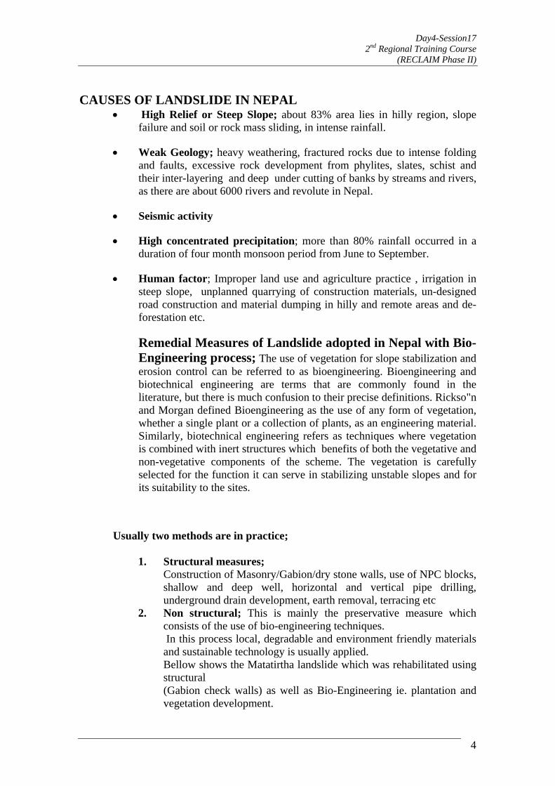
Day4-Session17 2nd Regional Training Course
(RECLAIM Phase II)
4
CAUSES OF LANDSLIDE IN NEPAL • High Relief or Steep Slope; about 83% area lies in hilly region, slope
failure and soil or rock mass sliding, in intense rainfall.
• Weak Geology; heavy weathering, fractured rocks due to intense folding and faults, excessive rock development from phylites, slates, schist and their inter-layering and deep under cutting of banks by streams and rivers, as there are about 6000 rivers and revolute in Nepal.
• Seismic activity
• High concentrated precipitation; more than 80% rainfall occurred in a duration of four month monsoon period from June to September.
• Human factor; Improper land use and agriculture practice , irrigation in steep slope, unplanned quarrying of construction materials, un-designed road construction and material dumping in hilly and remote areas and de-forestation etc.
Remedial Measures of Landslide adopted in Nepal with Bio-Engineering process; The use of vegetation for slope stabilization and erosion control can be referred to as bioengineering. Bioengineering and biotechnical engineering are terms that are commonly found in the literature, but there is much confusion to their precise definitions. Rickso"n and Morgan defined Bioengineering as the use of any form of vegetation, whether a single plant or a collection of plants, as an engineering material. Similarly, biotechnical engineering refers as techniques where vegetation is combined with inert structures which benefits of both the vegetative and non-vegetative components of the scheme. The vegetation is carefully selected for the function it can serve in stabilizing unstable slopes and for its suitability to the sites.
Usually two methods are in practice;
1. Structural measures; Construction of Masonry/Gabion/dry stone walls, use of NPC blocks,
shallow and deep well, horizontal and vertical pipe drilling, underground drain development, earth removal, terracing etc
2. Non structural; This is mainly the preservative measure which consists of the use of bio-engineering techniques.
In this process local, degradable and environment friendly materials and sustainable technology is usually applied.
Bellow shows the Matatirtha landslide which was rehabilitated using structural
(Gabion check walls) as well as Bio-Engineering ie. plantation and vegetation development.
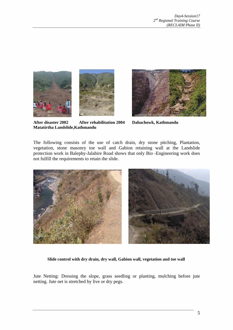
Day4-Session17 2nd Regional Training Course
(RECLAIM Phase II)
After disaster 2002 After rehabilitation 2004 Dahachowk, Kathmandu Matatirtha Landslide,Kathmandu The following consists of the use of catch drain, dry stone pitching, Plantation, vegetation, stone masonry toe wall and Gabion retaining wall at the Landslide protection work in Balephy-Jalabire Road shows that only Bio -Engineering work does not fulfill the requirements to retain the slide.
Slide control with dry drain, dry wall, Gabion wall, vegetation and toe wall Jute Netting: Dressing the slope, grass seedling or planting, mulching before jute netting. Jute net is stretched by live or dry pegs.
5

Day4-Session17 2nd Regional Training Course
(RECLAIM Phase II)
Bamboo Netting: This can be the alternative of coir netting. the mesh size depends on the slope and soil type. Bamboo fencing: It is used for soil retaining works.
6
se of HDPE/PP bags/Cement bags filled with sand or soil and packed in Nylon crates
Uor between bamboo poles or fence.

Day4-Session17 2nd Regional Training Course
(RECLAIM Phase II)
Use of PNC blocks for the Gully protection and Gabion Wall with vegetative layers for landslide control.
Turfing of surface channels and stone soling controls erosion and construction of proper pervious underground drain reduces the water table improving the soil surface .
7
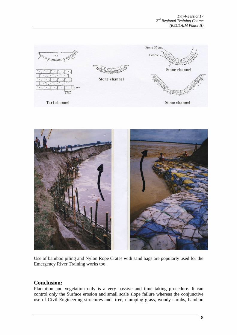
Day4-Session17 2nd Regional Training Course
(RECLAIM Phase II)
8
se of bamboo piling and Nylon Rope Crates with sand bags are popularly used for the mergency River Training works too.
onclusion: lantation and vegetation only is a very passive and time taking procedure. It can
Surface erosion and small scale slope failure whereas the conjunctive use of Civil Engineering structures and tree, clumping grass, woody shrubs, bamboo
UE CPcontrol only the

Day4-Session17 2nd Regional Training Course
(RECLAIM Phase II)
9
roper alignment of the roads, Irrigation canals and their periodic maintenance helps to duce this disaster. Use of proper species of plants and vegetations, cropping pattern
ion schemes depending upon the slope and soil structure are
plantation and herbs like vegetations are the most effective measure even in mass Landslide protections. Recommendations:Preand development of irrigatalso self disaster reducing factors.
Day5-Session18 2nd Regional Training Course
(RECLAIM Phase II)
1
State of the practice in slope mitigation measures: Focus on the Philippines
Mark Albert H. Zarco, Sandra G. Catane, and Rhodora M. Gonzalez
University of the Philippines Diliman, Quezon City
Abstract Confluence of geologic, geographic, and climatic factors makes the Philippines prone to natural disasters, particularly from landslides; most of them are soilslides involving the soil mantle and weathered rocks. Recent major landslide occurrences have claimed hundreds of lives and caused significant property damage: Cherry Hills-Antipolo (1999), Panaon Island-Surigao (2003), Aurora-Quezon (2004), St. Bernard, Southern Leyte (2006), and more recently on 1 December 2006, mudflows triggered by tropical storm Reming (Durian) devastated the communities around Mayon Volcano, killing 753 people and destroying P1.7 billions worth of property. Despite the high frequency of landslides in the Philippines, monitoring of critical slopes is almost non-existent. In the few cases where critical slopes are monitored, this is usually done visually due to the high cost and the risk of pilferage of slope monitoring devices. Problematic slopes are most frequently stabilized by modifying the slope geometry and constructing retaining structures, usually with a combination of bench and grouted riprap walls. In recent years, gabion and geotextile retaining walls have started to replace riprap walls due to their superior performance; soil nailing and rock anchoring have increased. Biotechnical methods such as planting of deep rooted grasses along problematic slopes are also being used in many areas in the Philippines. Improvement or installation of subsurface drainage is not frequently done despite water being a major destabilizing factor in most slopes. With its adverse geologic and climatic conditions, the Philippines will continue to suffer from the disastrous effects of landslides unless appropriate preparedness and mitigation measures are instituted. Research on the natural processes attendant to landslides, and creation of new tools and models for all phases of a disaster is paramount; these need high quality data for use in models for risk analysis, forecasting and early warning. Remote sensing and GIS technologies can facilitate in acquiring, managing, visualizing and analyzing geospatial data related to disasters. A site for the Landslide Mitigation Demonstration Project (LMDP) under the RECLAIM program of the ADPC is proposed in a landslide area of Baguio City, a thickly populated mountain area in the northern Philippine uplands. Its cool weather draws in many settlers and vacationers from all over the country. It is prone to landslides because of its steep terrain and for being traversed by the northern

Day5-Session18 2nd Regional Training Course
(RECLAIM Phase II)
2
splay of the Philippine Fault Zone. It is a very suitable and important site to demonstrate landslide mitigation measures. Keywords: landslide, landslide characterization, slope stability, slope mitigation, remote sensing, GIS, geohazard mapping, disaster preparedness
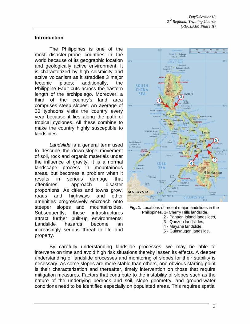
Day5-Session18 2nd Regional Training Course
(RECLAIM Phase II)
Introduction The Philippines is one of the most disaster-prone countries in the world because of its geographic location and geologically active environment. It is characterized by high seismicity and active volcanism as it straddles 3 major tectonic plates; additionally, the Philippine Fault cuts across the eastern length of the archipelago. Moreover, a third of the country’s land area comprises steep slopes. An average of 30 typhoons visits the country every year because it lies along the path of tropical cyclones. All these combine to make the country highly susceptible to landslides.
3
Landslide is a general term used to describe the down-slope movement of soil, rock and organic materials under the influence of gravity. It is a normal landscape process in mountainous areas, but becomes a problem when it results in serious damage that oftentimes approach disaster proportions. As cities and towns grow, roads and highways and other amenities progressively encroach onto steeper slopes and mountainsides. Subsequently, these infrastructures attract further built-up environments. Landslide hazards become an increasingly serious threat to life and property.
Fig. 1. Locations of recent major landslides in the Philippines. 1- Cherry Hills landslide, 2 - Panaon Island landslides, 3 - Quezon landslides, 4 - Mayana landslide, 5 - Guinsaugon landslide.
By carefully understanding landslide processes, we may be able to intervene on time and avoid high risk situations thereby lessen its effects. A deeper understanding of landslide processes and monitoring of slopes for their stability is necessary. As some slopes are more stable than others, one obvious starting point is their characterization and thereafter, timely intervention on those that require mitigation measures. Factors that contribute to the instability of slopes such as the nature of the underlying bedrock and soil, slope geometry, and ground-water conditions need to be identified especially on populated areas. This requires spatial
Day5-Session18 2nd Regional Training Course
(RECLAIM Phase II)
4
inventory and monitoring of susceptible areas for ground movement, as well as locating human activity which should be protected or stopped. For being in a country that is highly prone to landslides, Filipinos have to be prepared and protected from the impending disasters around them. Unfortunately, despite the increasing number of disastrous landslides, no effort has ever been made to monitor critical slopes in the Philippines for the contributory factors in order to serve as inputs for comprehensive studies of landslide processes. Much less is the inventory and categorization of slope susceptibility in the country to better prepare for and mitigate impending catastrophes. This paper is a review of the different types of recent landslide occurrences and the state of the practice in slope mitigation in the Philippines. Facilitation of the effort to characterize important slopes through the use of geoinformation technologies, Remote Sensing and GIS, is highlighted. People in an environment predisposed to natural hazards need crucial spatial information to learn to adapt, to live safely amidst such natural occurrences. A methodology to integrate geophysical and geotechnical slope characterization in a GIS environment is proposed. 1. Recent landslide occurrences in the Philippines
Catastrophic landslides have recently been increasing in the Philippines, even surpassing the combined effects of volcanic eruptions and earthquakes. This section surveys the most recent landslide occurrences in the country in order to look for similarities and differences in the events. Climatic conditions and soil and bedrock characteristics are noted. The triggers usually take the form of an earthquake, heavy rainfall, and human activities (e.g. quarrying, logging). Ideally, once the areas or a slope susceptible to failure is identified, they are either permanently avoided or are monitored for early warning; otherwise, engineering intervention measures must be carried out. Cherry Hills landslide, Antipolo City, Luzon Island On 3 August 1999, after several days of continuous heavy rainfall, a landslide occurred in Cherry Hills Subdivision, San Luis Village in Antipolo City, 32 Km east of Manila (Fig 2.). It destroyed about 379 houses resulting in the death of at least 58 people. The subdivision was developed on the moderately sloping terrain in Antipolo City, with the highest point at 230 m above sea level and the 25% original gradient prior to development (Orense, 2003). Rocks in the area consist of highly fractured, sedimentary sequence of interbedded sandstone, siltstone and claystone formed in fluvial to lacustrine environments (Maglambayan, 1999). Metamorphosed basalts lie beneath the sedimentary sequence. As early as November 1998, some residents already observed cracks on the walls of some houses in the area. They claimed that whenever it rained hard,

Day5-Session18 2nd Regional Training Course
(RECLAIM Phase II)
sudden cracking of walls and windows occurred. Numerous cracks were at the height of the intense and continuous rain that started four days before the event. 565 mm of rainfall had been recorded from 31 July to 2 August 1999, which exceeded the annual average rainfall of the area. Although some residents were evacuated due to increased signs of impending landslide such as bulging of floor pavements, many failed to leave because of the heavy rainfall. The landslide occurred very quickly, according to eyewitness reports. Two loud noises were heard, and the movement was over in about five seconds. A very steep scarp carved out at the portion of the east hill facing the subdivision; it consisted of slumping and rotational components. The scarp is about 30 m high and 200 m wide. The volume of material is at least 100,000 cubic meters and most materials moved downslope for about 150 m.
Thickness of failed mass near the toe of the landslide was as much as 12 m. Some portions of the subdivision road buckled as a result of ground deformation as shown in Figure 2.
Fig. 2 The Cherry Hills landslide in Antipolo City. Photo by Punongbayan (1999).
A subsequent field investigation by Maglambayan et al. (1999) showed that excavation related to the construction of the subdivision led to oversteeping of slopes. Heavy rainfall may have accelerated the creep and triggered the landslide
5

Day5-Session18 2nd Regional Training Course
(RECLAIM Phase II)
6
Based on the analysis of geologic structures, degree of damage to the
des, Southern Leyte
rom 17 to 20 December 2003, numerous landslides and flashfloods occurred in s
bout ten days prior to the landslides, a low pressure area at the southeastern par
(Orense, 2003). Hydrostatic pressure developed along fractures may have made the slope unstable. houses, and interviews with local residents, Maglambayan et al. (1999) proposed a 3-stage model to characterize the development of the landslide. The stages are: 1) creeping deformation, 2) minor slippage at the toe of the potential land mass, 3) rapid slope failure along a deeper slip surface, and 4) rapid slope failure producing a complex landslide. Panaon Island landsli
Fouthern Philippines, specifically in the provinces of Southern Leyte, Surigao,
and Agusan (Cabria and Catane, 2003). The most catastrophic of them occurred on 19 December in Panaon Island, Southern Leyte. Hundreds of people were killed and injured, while more were left homeless (Fig. 3). According to the Mines and Geosciences Bureau (MGB) – VIII (Leones and others, 2004; MGB-CO, 2004) in Panaon Island alone, 151 people were killed and 34 were injured. A total of 222 houses were completely destroyed, while 329 were partially damaged.
At of the country brought continuous heavy rains to these provinces. Historically,
the average monthly rainfall for southern Leyte is 178 mm; but for only three days, from 18 to 20 December 2003, the rainfall reached 699 mm, which is almost four times greater than the monthly average (MGB-CO, 2004).
Day5-Session18 2nd Regional Training Course
(RECLAIM Phase II)
Fig. 3 Photo of landslides in Punta, San Francisco, Panaon Island, Southern Leyte.
December 17 – 20, 2003. The landslide on the left buried the village killing 151 persons. Photo by the Philippine Star (2003).
The landslides originated from a moderately steep slope (between 30 to 40 degrees) with thick soil cover. The presence of natural escarpment may have accelerated the movement because it increases the potential energy. The affected areas are underlain by thick soil horizons, which are possibly made up of expansive clays, common in volcanic terrain. Most of the landslides involved debris and earth materials rather than rocks. The slip planes developed between weak and thick soil horizons and the more coherent and stronger bedrock. The mechanism is dominated by rapid soil slide that transformed into debris flow, signifying the saturated nature of the slope materials.
Additionally, conversion of the land cover from primary forest to agricultural coconut plantation has also decreased the shear strength of materials on the slopes; the coconut trees are shallow-rooted. Although faults and fractures did not directly contribute to the causes the landslides, the proximity of the island to the Philippine Fault Zone suggests that fracturing of rocks may have accelerated the weathering process of the volcanic rocks that make up Panaon island. Quezon landslides, Luzon Island
7
Day5-Session18 2nd Regional Training Course
(RECLAIM Phase II)
From mid-November to early December 2004, 3 typhoons and tropical storms struck Luzon Island in two weeks; this resulted in massive landslides that caused 1600 deaths and an estimated damage of US$ 78.2 M (Orense, 2004). The hardest hit were the towns of Real, Infanta and General Nakar, all in Quezon Province. Damage to civil engineering structures was also extensive, with numerous houses and five bridges washes away by mudflows and flashfloods. On the morning of 29 November, during the passage of storm Winnie, a rain gauge in Infanta recorded 342 mm of rain during a 9-hr period, after which no more rainfall data was unavailable because the floods washed away the rain gauge. About 30% of the average annual precipitation or about twice the average monthly precipitation fell within the 2.5-week period. This rainfall corresponds to the one
with a return period in the order of 100 yrs (Orense, 2004). An aerial survey showed that in the southeastern part of Sierra Madre Mountain Range where Quezon Province lies, numerous landslides occurred even in heavily forested areas. Trees, together with huge masses of soil, slid down the slopes. Most of the landslides involved only the soil mantle and were not deep-seated; but minor rockslides and rockfalls also occurred along the streams. In the town of Real, about 100 persons were trapped when a three-storey building that was used as an evacuation site collapsed due to the impact of a landslide. Mudflows and debris-laden floods, and debris blocked major sections of the national highway and damaged the bridges; Real and adjacent towns were inaccessible to traffic for several weeks.
8
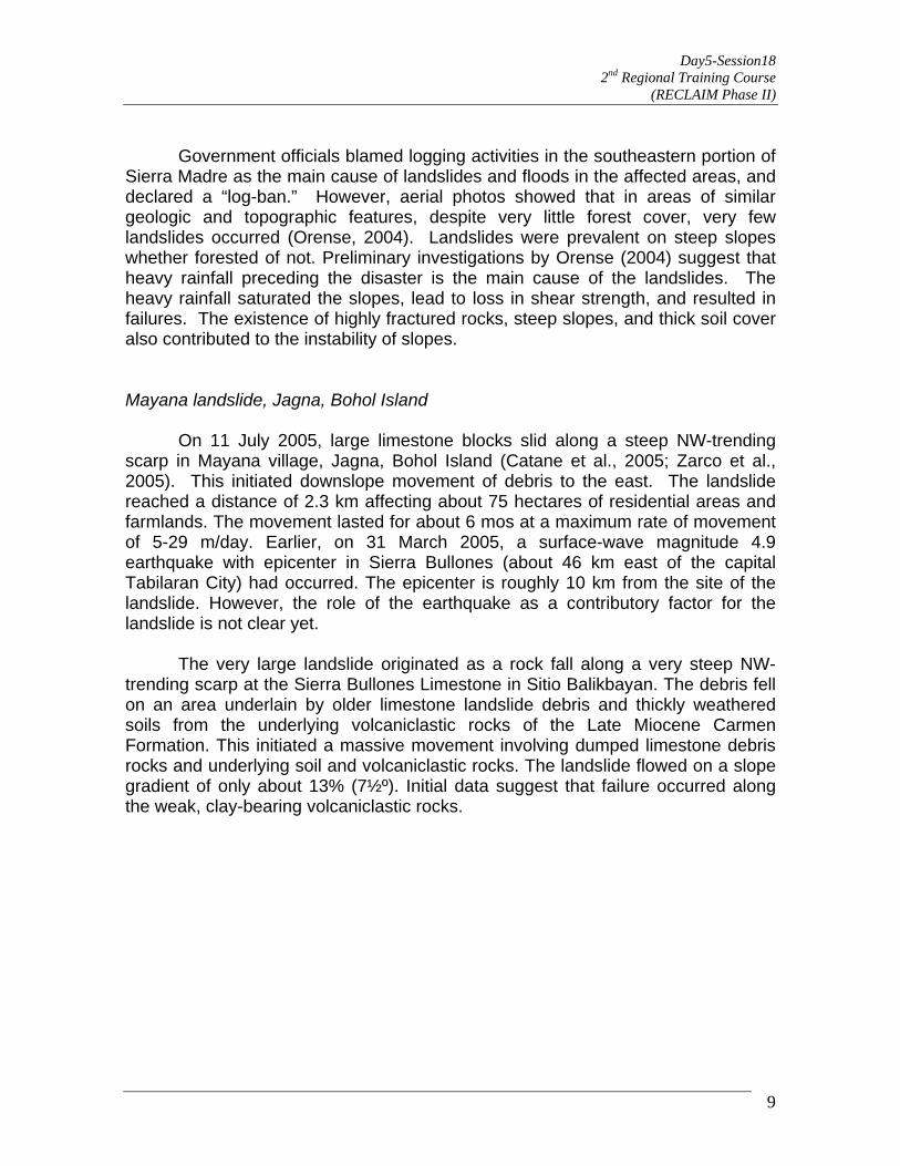
Day5-Session18 2nd Regional Training Course
(RECLAIM Phase II)
9
Government officials blamed logging activities in the southeastern portion of
Sierra Madre as the main cause of landslides and floods in the affected areas, and declared a “log-ban.” However, aerial photos showed that in areas of similar geologic and topographic features, despite very little forest cover, very few landslides occurred (Orense, 2004). Landslides were prevalent on steep slopes whether forested of not. Preliminary investigations by Orense (2004) suggest that heavy rainfall preceding the disaster is the main cause of the landslides. The heavy rainfall saturated the slopes, lead to loss in shear strength, and resulted in failures. The existence of highly fractured rocks, steep slopes, and thick soil cover also contributed to the instability of slopes. Mayana landslide, Jagna, Bohol Island
On 11 July 2005, large limestone blocks slid along a steep NW-trending scarp in Mayana village, Jagna, Bohol Island (Catane et al., 2005; Zarco et al., 2005). This initiated downslope movement of debris to the east. The landslide reached a distance of 2.3 km affecting about 75 hectares of residential areas and farmlands. The movement lasted for about 6 mos at a maximum rate of movement of 5-29 m/day. Earlier, on 31 March 2005, a surface-wave magnitude 4.9 earthquake with epicenter in Sierra Bullones (about 46 km east of the capital Tabilaran City) had occurred. The epicenter is roughly 10 km from the site of the landslide. However, the role of the earthquake as a contributory factor for the landslide is not clear yet.
The very large landslide originated as a rock fall along a very steep NW-trending scarp at the Sierra Bullones Limestone in Sitio Balikbayan. The debris fell on an area underlain by older limestone landslide debris and thickly weathered soils from the underlying volcaniclastic rocks of the Late Miocene Carmen Formation. This initiated a massive movement involving dumped limestone debris rocks and underlying soil and volcaniclastic rocks. The landslide flowed on a slope gradient of only about 13% (7½º). Initial data suggest that failure occurred along the weak, clay-bearing volcaniclastic rocks.
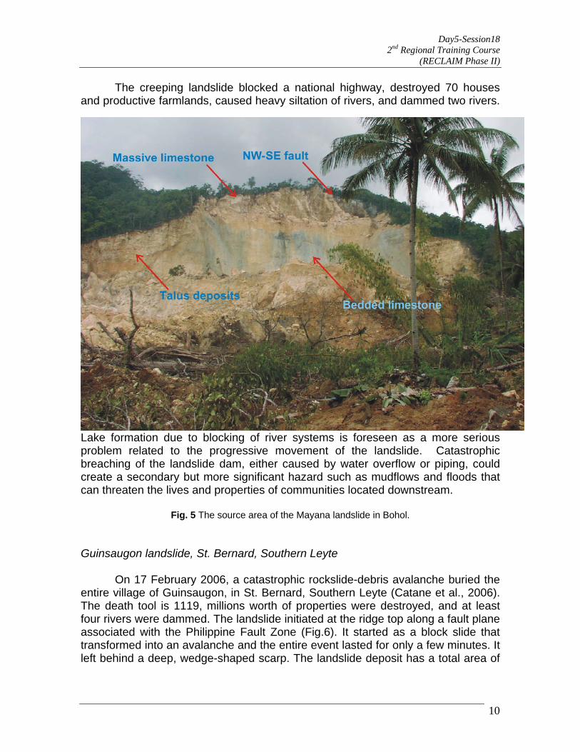
Day5-Session18 2nd Regional Training Course
(RECLAIM Phase II)
The creeping landslide blocked a national highway, destroyed 70 houses and productive farmlands, caused heavy siltation of rivers, and dammed two rivers.
Lake formation due to blocking of river systems is foreseen as a more serious problem related to the progressive movement of the landslide. Catastrophic breaching of the landslide dam, either caused by water overflow or piping, could create a secondary but more significant hazard such as mudflows and floods that can threaten the lives and properties of communities located downstream.
Fig. 5 The source area of the Mayana landslide in Bohol.
Guinsaugon landslide, St. Bernard, Southern Leyte On 17 February 2006, a catastrophic rockslide-debris avalanche buried the entire village of Guinsaugon, in St. Bernard, Southern Leyte (Catane et al., 2006). The death tool is 1119, millions worth of properties were destroyed, and at least four rivers were dammed. The landslide initiated at the ridge top along a fault plane associated with the Philippine Fault Zone (Fig.6). It started as a block slide that transformed into an avalanche and the entire event lasted for only a few minutes. It left behind a deep, wedge-shaped scarp. The landslide deposit has a total area of
10

Day5-Session18 2nd Regional Training Course
(RECLAIM Phase II)
3.2 km2 and a runout distance of 4.1 km. Estimated volume of debris range from 14-18 M m3. Intense precipitation and earthquakes preceding the landslide are potential triggers but the role of each has not been elucidated. A rain gauge located 7 km west of Guinsaugon measured cumulative rainfall of 751 mm from 1 to 16 February; this is 2.6 times higher than the average February rainfall. Two earthquakes, with magnitudes of 2.3 Ms (06:07AM) and 4.3 Ms (10:36AM), respectively, were recorded on the day of the landslide.
Fig. 6 The Guisaugon landslide and its features. Photo by M.D. Kennedy (U.S. Navy, 2006) 2. Slope Protection and Stabilization Practices in the Philippines
Despite the common and recurring landslides that exact heavy tolls on human lives, as well as the amount of property lost each year (Orense, 2003), mitigation of landslide risk is not a widespread practice in the Philippines. Compared with the well-developed monitoring and warning systems for typhoons, earthquakes, and volcanic eruptions, the corresponding systems for landslides and
11

Day5-Session18 2nd Regional Training Course
(RECLAIM Phase II)
slope failures are not as well established. However, engineering countermeasures for reducing landslide risk are observable; these generally involve the use of slope stabilization methods such as benching, improvement of subsurface drainage, construction of retaining structures, and reinforcement of slopes. Majority of these slope stabilization measures are undertaken in connection with road construction projects. This section briefly describes the current engineering practices in the Philippines for stabilizing and/or protecting precarious slopes (Fig. 7).
Fig. 7 Rockslides along Helsema Highway, northern Philippines. Unloading
Unloading is the procedure for reducing the driving forces within a slide mass. This is undertaken by removing materials from the upper part of the slope, removing loose and unstable materials, flattening of the slope or benching (Abramson, 1996). Removal of the head of a landslide involves excavating relatively large quantities of material from the head of a slope. This reduces the driving forces and tends to balance the failure. In practice, this method is usually applied to existing failures. It usually leads to fairly permanent solutions when adequate drainage is provided. The main advantage of this procedure is it’s typically low cost. Some disadvantages associated with unloading include accessibility and right-of-way issues, implementing and maintaining safety
12
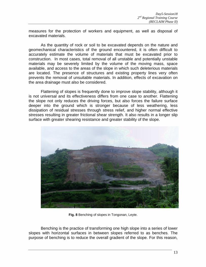
Day5-Session18 2nd Regional Training Course
(RECLAIM Phase II)
measures for the protection of workers and equipment, as well as disposal of excavated materials.
As the quantity of rock or soil to be excavated depends on the nature and
geomechanical characteristics of the ground encountered, it is often difficult to accurately estimate the volume of materials that must be excavated prior to construction. In most cases, total removal of all unstable and potentially unstable materials may be severely limited by the volume of the moving mass, space available, and access to the areas of the slope in which such deleterious materials are located. The presence of structures and existing property lines very often prevents the removal of unsuitable materials. In addition, effects of excavation on the area drainage must also be considered.
Flattening of slopes is frequently done to improve slope stability, although it
is not universal and its effectiveness differs from one case to another. Flattening the slope not only reduces the driving forces, but also forces the failure surface deeper into the ground which is stronger because of less weathering, less dissipation of residual stresses through stress relief, and higher normal effective stresses resulting in greater frictional shear strength. It also results in a longer slip surface with greater shearing resistance and greater stability of the slope.
Fig. 8 Benching of slopes in Tongonan, Leyte. Benching is the practice of transforming one high slope into a series of lower
slopes with horizontal surfaces in between slopes referred to as benches. The purpose of benching is to reduce the overall gradient of the slope. For this reason,
13

Day5-Session18 2nd Regional Training Course
(RECLAIM Phase II)
14
benches should be sufficiently wide. As a general rule of thumb, benches should be designed so as to have a minimum width of one-half the height of the adjacent slope. However, this rule is very rarely followed in the Philippines. Figure 8 illustrates an example of the use of benching to stabilize a slope in Tongonan, Leyte. The slope was excavated to create a series of shorter slopes with a gradient of 1V:1.5H and ranging in height from 10m to 15m. Benches were generally 2m in width, with the exception of two 5m wide benches which were pre-existing access roads. Drainage
Installing proper drainage minimizes the destabilizing effects of hydrostatic and seepage forces on a slope, as well as reduces the risk of erosion and piping (Abramson 1996). In the Philippines, the most widely used drainage technique is the installation of surface drains to carry away surface runoff and prevent it from seeping into the slope. A system of open channels lined with semicircular corrugated PVC liners or concrete are frequently used for this purpose (Fig. 9).
While being the most widely used technique for stabilizing slopes with
existing structures, experience indicates this method is only moderately successful in preventing slope failures because of either faulty design or poor maintenance. Surface drains are often improperly placed such that they do not adequately intercept surface runoff. In other cases, drains frequently do not have sufficient capacity to accommodate the surface runoff that it intercepts. Even for properly designed surface drainage systems, the lack of periodic maintenance can result in the accumulation of debris in the drainage channels, thereby reduce the capacity of the system to intercept surface runoff. Concrete lined channels are prone to cracking and require periodic repair. Failure to undertake such repairs frequently results in runoff water seeping into the slope.

Day5-Session18 2nd Regional Training Course
(RECLAIM Phase II)
Fig. 9 Slope stabilization using sub-horizontal drains. Installation of subsurface drainage is often undertaken in cases involving
high groundwater seepage or artesian pressures. Improvement of subsurface drainage is frequently accomplished using cut-off drains and trenches. This usually involves excavating a trench of sufficient depth, and installing perforated PVC pipes within a graded pebble filter, and then sealing the trench with a clay cap. In cases where involving rock slopes or where the depth precludes excavation of a trench, horizontal or sub-horizontal drains are used instead.
Figure 9 illustrates the key features of a horizontal drain system. Drainage
holes 5cm to 7cm are drilled into the slope, and a perforated drainage pipe is installed. The perforations are normally covered with a geosynthetic filter to prevent sediments from entering and clogging the pipe. A clay cap is used to fasten the pipe to the slope, and prevent seepage out of the slope through the sides of the drainage pipe. Water draining from pipes is diverted away from the slope using surface drainage channels.
Grouted Riprap
In cases of nearly vertical slopes, slope faces are protected using grouted rip-rap. Grouted rip-rap involves the placement of rounded, cobble, and boulder sized rocks against the slope face. Figure 10 shows the typical construction of a rip-rap wall used for slope protection of roads. Rocks are held together using cement mortar placed in between rocks. The resulting structure serves both as a gravity retaining structure as well as a slope and erosion control measure. Due to the limited flexural strength of the resulting structure, rip-rap walls seldom exceed a
15
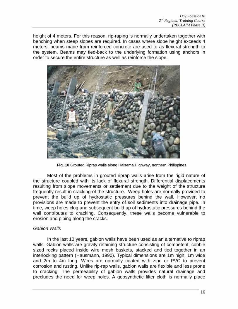
Day5-Session18 2nd Regional Training Course
(RECLAIM Phase II)
height of 4 meters. For this reason, rip-raping is normally undertaken together with benching when steep slopes are required. In cases where slope height exceeds 4 meters, beams made from reinforced concrete are used to as flexural strength to the system. Beams may tied-back to the underlying formation using anchors in order to secure the entire structure as well as reinforce the slope.
Fig. 10 Grouted Riprap walls along Halsema Highway, northern Philippines. Most of the problems in grouted riprap walls arise from the rigid nature of
the structure coupled with its lack of flexural strength. Differential displacements resulting from slope movements or settlement due to the weight of the structure frequently result in cracking of the structure. Weep holes are normally provided to prevent the build up of hydrostatic pressures behind the wall. However, no provisions are made to prevent the entry of soil sediments into drainage pipe. In time, weep holes clog and subsequent build up of hydrostatic pressures behind the wall contributes to cracking. Consequently, these walls become vulnerable to erosion and piping along the cracks.
Gabion Walls
In the last 10 years, gabion walls have been used as an alternative to riprap walls. Gabion walls are gravity retaining structure consisting of competent, cobble sized rocks placed inside wire mesh baskets, stacked and tied together in an interlocking pattern (Hausmann, 1990). Typical dimensions are 1m high, 1m wide and 2m to 4m long. Wires are normally coated with zinc or PVC to prevent corrosion and rusting. Unlike rip-rap walls, gabion walls are flexible and less prone to cracking. The permeability of gabion walls provides natural drainage and precludes the need for weep holes. A geosynthetic filter cloth is normally place
16

Day5-Session18 2nd Regional Training Course
(RECLAIM Phase II)
behind the wall during construction prior to backfilling to prevent erosion of backfill soils as shown in Figure 11. More recently, mechanically stabilized slopes involving the use of gabion walls together with geogrid reinforcements have been used on a limited scale.
Fig.11 Applications of Gabion Walls in the Philippines.
Local experience with gabion walls is very good. In majority of the cases, the use of gabion walls proved to be an effective means of either preventing slope failure, or strengthening a previous slope failure. This can be attributed to the fact that a greater amount of engineering effort is put into the design of gabion walls as compared to grouted riprap walls. Nonetheless, this together with the cost of materials translates into gabion walls being more expensive compared to riprap walls. The added expense has prevented the wide use of gabion walls.
Soil Nailing and Rock Anchoring
17

Day5-Session18 2nd Regional Training Course
(RECLAIM Phase II)
Soil nailing is a method of reinforcement that utilizes passive inclusions that
will be mobilized if and when movement occurs. It is usually done to retain excavations and stabilize slopes by creating an in-situ, reinforced soil mass (Xanthakos, 1994). In the Philippines, soil nailing is often employed to stabilize the soil mantle of excavations undertaken during construction of multi-level basement structures (Fig. 12). The process of stabilizing an excavation face involves both drilling and inserting nails into the slope, and then protecting the exposed slope using wire-reinforced shotcrete. In principle, soil nails are installed without any stressing forces. However in order to minimize the amount of movement required to mobilize resisting in the nail, it is common to use a minimal force normally ranging between 2 tons to 5 tons.
Fig. 12 Soil nailing and rock bolting, RCBC Plaza, Makati City, Metro Manila.
In cases involving exposed rock faces, rock bolting or anchoring is commonly employed as a means of temporarily maintaining the stability of vertical rock slopes. Rock anchoring increases the normal stress within the rock to increase shear strength, and close up joints in order to minimize seepage.
Although experience with rock anchoring and soil nailing has generally been good, a number of slope failures in excavations have occurred in the last 10 years.
18

Day5-Session18 2nd Regional Training Course
(RECLAIM Phase II)
Most of these cases occurred due to inability to control seepage into the excavation. Very often, ground settlements required to mobilize the passive resistance of the soil nails result in movement and cracking of water mains and sewage lines. The resulting insipient seepage increasingly saturates the soil mantle, resulting both in an increased unit weight as well as a decrease in the shear strength of the mantle soils. Rockfall Barriers and Rockslide Shelters
In recent years, rockfall barriers and shelters have been used to protect major roads and pipelines in mountainous areas. Barriers are designed to withstand the impact, as well as stop or divert falling boulders. They consist of wire mesh fences supported on concrete or metal post. The wires used for mesh fences are generally coated with zinc or PVC to minimize corrosion. Fence posts are frequently braced using struts or cables to increase lateral resistance. Local experience indicates that such structures require regular maintenance involving removal of rockfall debris and repair of fences. The combined cost of constructing the fence as well as maintaining it has limited the use of rockfall barriers in the Philippines. They are mostly done for slope protection along roadways with occasional rockfalls. Figure 13 shows the rock shelter along Marcos Highway, leading up to the city of Baguio.
Fig. 13 Rockslide shelter and barrier along the highway leading to Baguio City.
Rockslide shelters are used on slopes where frequent rockslides occur. They generally consist of massive reinforced concrete structures that enclose the roadway and pipelines, thereby protecting them from falling boulders. They are specifically designed to withstand high amounts of kinetic energy. Despite
19

Day5-Session18 2nd Regional Training Course
(RECLAIM Phase II)
20
their cost, which is much higher compared to all other rockfall protection measures, they are very effective in protecting major roadways from frequent, large scale rockfalls. They also require minimal cost and effort to maintain once constructed. Consequently, rockslide shelters are usually the chosen method for protecting major roads and vital pipelines in mountainous areas.
3. Geoinformation technologies for landslide studies and mitigation
In the last two decades, development in geoinformation technologies for spatial data acquisition and analysis techniques such as remote sensing, and the advent of Geographical Information Systems (GIS) to integrate data from disparate sources have opened new possibilities for the application of these tools in studying the environment. Mantovani et al. (1996:213) listed several ways by which geoinformation technologies can facilitate the study of landslides and their subsequent mitigation:
a. Detection and classification of landslides; b. Monitoring of detected landslides; c. Analysis and prediction of slope failures.
Examples of successful implementation on such uses are available (Fedra, 1998; Mantovani, et al. op. cit.; Remondo, et al. 2003). However, in the context of developing countries such as the Philippines, availability of funds to acquire the needed images and equipment, as well as relevant training for their effective use hamper their application and limit the benefits offered by these emerging technologies when combined with geological and geotechnical analyses. A demonstration project to show the principles is therefore proposed. Firstly, gathering of data on the history of landslide occurrences and attendant factors in a study area is necessary; this is important in determining vulnerability of the area and corresponding advice to the population. There have been no thorough documentation and gathering of geophysical data despite the many landslides that occur in the country; attention is more focused on relief and rehabilitation of the affected population. Triggering mechanisms, particular to the area, that influence instability and failure have to be identified and noted as well; they become the crucial indicators of imminent dangers. The variability and distribution of soils and geologic units have to be mapped; those that are most prone to instability and those that are the most stable need to be differentiated. Thereafter, the spatial distribution of instability can be delineated; this will guide the determination of high risk areas where mitigation is focused. The literature suggests various techniques at identifying and characterizing slopes using remote sensing and GIS together with geological and geophysical information (Temesgen
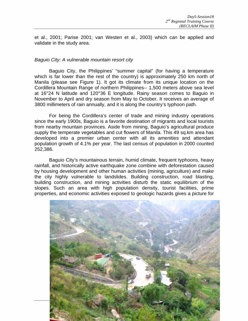
Day5-Session18 2nd Regional Training Course
(RECLAIM Phase II)
et al., 2001; Parise 2001; van Westen et al., 2003) which can be applied and validate in the study area. Baguio City: A vulnerable mountain resort city Baguio City, the Philippines’ “summer capital” (for having a temperature which is far lower than the rest of the country) is approximately 250 km north of Manila (please see Figure 1). It got its climate from its unique location on the Cordillera Mountain Range of northern Philippines-- 1,500 meters above sea level at 16°24 N latitude and 120°36 E longitude. Rainy season comes to Baguio in November to April and dry season from May to October. It receives an average of 3800 millimeters of rain annually, and it is along the country’s typhoon path. For being the Cordillera’s center of trade and mining industry operations since the early 1900s, Baguio is a favorite destination of migrants and local tourists from nearby mountain provinces. Aside from mining, Baguio’s agricultural produce supply the temperate vegetables and cut flowers of Manila. This 49 sq.km area has developed into a premier urban center with all its amenities and attendant population growth of 4.1% per year. The last census of population in 2000 counted 252,386.
21
Baguio City’s mountainous terrain, humid climate, frequent typhoons, heavy rainfall, and historically active earthquake zone combine with deforestation caused by housing development and other human activities (mining, agriculture) and make the city highly vulnerable to landslides. Building construction, road blasting, building construction, and mining activities disturb the static equilibrium of the slopes. Such an area with high population density, tourist facilities, prime properties, and economic activities exposed to geologic hazards gives a picture for

Day5-Session18 2nd Regional Training Course
(RECLAIM Phase II)
22
an impending disaster. However, no serious monitoring and study about this grave danger is being done yet.
Fig. 14 Overview of Baguio City’s expanding community on mountain slopes
Leonen (2000) writes, “Sinkholes are quite common in Baguio City, which also has at least seven known faults and numerous areas vulnerable to landslides. Landslides could be triggered by an earthquake or continuous rainfall, which can also cause sinkholes to wreak havoc. Because Baguio has one of the 10 highest daily rainfall records in the world and is visited by an average of five cyclones in a three-year period, landslides and sinkhole-related mishaps are givens.
This and the presence of the faults—cracks or gaps in geological plates, the sudden movement of which causes earthquakes—are most probably why the World Bank lists Baguio as among the top seven risk-prone cities in Asia. But while Baguio officials are well aware of the delicate nature of their city, little has been done to discourage people from constructing homes and even buildings in areas where the ground is unstable.”
In view of the critical condition of Baguio City, it will be studied for the Landslide Mitigation Demonstration Project (LMDP) under the RECLAIM program of the ADPC. It aims to develop a demonstration project for the investigation, instrumentation, and structural mitigation of a landslide-prone area in the Philippines that may serve as a basis for methodology replication in other landslide vulnerable areas. In the process, a database of critical slopes shall be built in an effort to better understand the mechanics of impending landslides. This will be used to generate a GIS-based engineering geologic map and risk map that would show the highly susceptible areas to landslides. Thereafter, local government shall be enjoined to incorporate these measures in their local disaster preparedness plan.
References:
Abramson, L. W., T. S. Lee S. Sharma and G. M. Boyce. 1996. Slope Stability and Stabilization Methods. John Wiley and Sons, 627pp. Cabria, HB and Catane SG, 2003. The 19 December landslides in Panaon Island, Southern Leyte, Philippines. QRT Report, National Institute of Geological Sciences, University of the Philippines, Diliman, Quezon City, 13 p. Catane, S.G., Foronda, J. and Tomarong, CP, Jr., 2005. Assessment of Hazards Resulting from the July 11, 2005 Landslide, Barangay Mayana, Jagna Bohol. Technical Report prepared for the Local Government Unit of Jagna, Bohol. National Institute of Geological Sciences, University of the Philippines, Diliman, Quezon City, 6 p.

Day5-Session18 2nd Regional Training Course
(RECLAIM Phase II)
23
Catane, SG, Cabria, HB, Tomarong, CP Jr, Saturay, RM Jr., Zarco, MAH, Pioquinto WC. 2006. Catastrophic rockslide-debris avalanche at St. Bernard, Southern Leyte, Philippines. Landslides DOI 10.1007/s10346-006-0050-3 Fedra, K. 1998. Integrated risk assessment and management: overview and state of the art. Journal of Hazardous Materials. 61:5-22. Godio, A., and Bottlno, G. 2001. Electrical and Electromagnetic Investigation for Landslide Characterization. Physical Chemical Earth (C). vol. 26(9):705-710. Haussman, M. 1990 Engineering Principles of Ground Modification. McGraw Hill,. 632 pp. Lee, S. and Evangelista, D. (undated) Landslide Susceptibility Mapping using Probability and Statistics Models in Baguio City, Philippines http://www.isprs.org/publications/related/ISRSE/html/papers/407.pdf Leonen, M. 2000. Ten Years after the Earthquake, Baguio is a Disaster Waiting to happen. http://www.pcij.org/stories/print/baguio.html Leones, J., Dupio, A., Tan, R., and Corias, R., 2004. Mass Movement at Panaon Island,Southern Leyte. http://www.mgb.gov.ph/leyte-Surigao/report%20on%20the%20mass%20movement%20at%20panaon%20island.pdf
Maglambayan, V.B., Catane, S.G. and J. Foronda. 1999. A proposed model for the 03 August 1999 Cherry Hills landslide. Antipolo City. In: Proceedings of the 12th Annual Geological Convention, Galleria, Mandaluyong City, Philippines. Mantovani, F., Soeters, R., and van Westen, C. 1996. Remote sensing techniques for landslide studies and hazard zonation in Europe. Geomorphology, vol 15:213-225. McKean, J. and Roering, J. 2004. Objective landslide detection and surface morphology mapping using high-resolution airborne laser altimetry. Geomorphology, vol. 57:331–351.
MGB-CO, 2004. The Southern Leyte-Surigao Landslides and Floodings: A Geohazard Perspective. http://www.mgb.gov.ph/leyte-surigao/leyte-surigao_geoperspective.htm
Miller, D., and Sias, J. 2004. Deciphering large landslides: linking hydrological, groundwater, and slope stability models through GIS. Hydrological Processes, vol. 12: 923-941. Orense, RP, 2004. Slope failures triggered by heavy rainfall. Philippine Engineering Journal, vol. 25, no. 1:1-18. Orense, RP, 2003. Geotechnical hazards-nature, assessment and mitigation. The University of the Philippines Press, Diliman, Quezon City, 510 p.
Parise, M. 2001. Landslide Mapping Techniques and Their Use in the Assessment of the Landslide Hazard. Reference to the Landslides in the Wondogenet Area, Ethiopia. Physical Chemical Earth (C). vol. 26(9):697-703. Remondo, J., González-Díez, A., Díaz De Terán, J. R. And Cendrero, A. 2003. Landslide Susceptibility Models Utilising Spatial Data Analysis Techniques. A Case Study from the Lower Deba Valley, Guipuzcoa (Spain). Natural Hazards. 00:1-13.

Day5-Session18 2nd Regional Training Course
(RECLAIM Phase II)
24
Temesgen, B., Mohammed, U. and Korme, T. 2001. Natural Hazard Assessment Using GIS and Remote Sensing Methods, with Particular Reference to the Landslides in the Wondogenet Area, Ethiopia. Physical Chemical Earth (C). vol. 26(9):665-671. Tarchi, D., Casagli, N.,Fanti, R. et al. 2003. Landslide monitoring by using ground-based SAR interferometry: An example of application to the Tessina landslide in Italy. Engineering Geology 68:15–30. van Westen, C. J., Rengers, N. and Soeters, R. 2003. Use of Geomorphological Information in Indirect Landslide Susceptibility Assessment. Natural Hazards, vol. 30:399-419. Xanthakos, P. P., L. W. Abramson and D. A. Bruce. 1994. Ground Control and Improvement. John Wiley and Sons. 910pp. Zarco, M.H., Catane, S.G., Foronda, J. and Tumarong, C, Jr., 2005. July 11, 2005 landslide, Barangay Mayana, Jagna, Bohol, In: 2005 Workshop and Meeting on Safety and Stability of Infrastructures Against Environmental Impacts (JSPS Core University Program on Environmental Engineering), De La Salle University, Manila, Philippines, 9 p.
Day5-Session21 2nd Regional Training Course
(RECLAIM Phase II )
1
Search for a Conducive Policy Environment for Landslide Risk
Reduction
Mr. N.M.S.I. Arambepola, Asian Disaster Preparedness Center (ADPC)
Bangkok, Thailand KEY OBJECTIVES
o To present the requirements for administrative, institutional and legal changes in the practice of Landslide risk management.
o To raise level of awareness of the necessity for integrating Landslide
hazard mitigation measures in the urban planning and management processes.
o To motivate participants to initiate actions for undertaking policy
changes to help mainstreaming risk management in to development practice to aid reduction of landslide risk.
SYNOPSIS
Any type of Policies related to disaster risk management and related actions should sensibly evolve from the data on losses and damages and hazard context. They are also the products of a history of hazard events, a human reaction to the consequences evolved from that history and the reflection of new perceptions on long-lasting solutions to the problems or concerns.
During the past history of disaster management , policies stem from an era of hazard control in which the emphasis was on the physical control of hazard generating factors or triggering factors through structural interventions with huge investments such as canalisation, retaining structures, embankments, reservoirs and dams. During this period - and again extending to our present day - these structures had other purposes: to provide irrigation waters, bulk drinking water supply and/or hydro-electrical power generation, road safety etc. However landslide protection measures are generally standalone measures and did not find the same popularity as flood or other hazard prevention measures since repayment for such investment for large scale protection measures was a problem.
From the early 1960's onwards non-structural measures of risk management were increasingly favoured. During this period interventions such as land use planning, the planned retreat of those in danger to safe refuges, the use of property insurance , prediction and early warning systems came in to effect. But landslide prone areas were comparatively smaller and rather than land use planning, resettlement has become the popular solution. This paved the way for high environment degradation process since

Day5-Session21 2nd Regional Training Course
(RECLAIM Phase II )
2
the authorities have not invested money in abandoned land due to landslide risk and owners of land after getting alternative land tend to occupy both lands and recurring events become a common feature...
In the 1970's after major floods in countries such as India, China, Bangladesh etc the authorities have introduced the twin concepts of settlement structure planning and national physical planning with an emphasis on improved land drainage, with the conceptualisation of a preparedness planning; together with elements of the earlier approach of hazard control and risk management approaches. But again that did not go too far in the case of landslides unless such preparedness programs were designed for multi-hazard situations.
In the 1990's with the introduction of IDNDR decade a new set of policies came in to recognition under the wider themes of water resource planning, regional environmental management, ecological and nature conservation management, regulatory development through zoning etc. Within this conceptualisation settlement expansion was seen intruding into a natural environment and landscape that already is seen to be heavily abused. Moreover such criteria were never used in mountain area development and landslide hazard was not considered as an essential factor under any of the above mentioned themes. In many countries Landslide risk management has become a neglected subject with few exceptions like the UNDP led Landslide Hazard mapping Project in Sri Lanka but it still fail to create a large enough impression for changes in notational policy for mountain area development.
Many countries in Asia are at an early stage of urbanisation and urban growth is visible in mountain slopes prone to landslides too. Yet many, if not most, predominantly mountainous areas of such countries are burdened with rising populations and thus rising expectations of housing and settlements, infrastructure facilities, lifelines etc. Unless these settlement trends are carefully planned and managed then road and rail transportation systems, urban settlements and tourism infrastructure, the spreading housing and industrial areas will all may aggravate the landslide problem. As the destabilized material is transported in to lower areas natural land drainage can get disturbed over large areas and increasing flooding will result. Settlements in the mountainous areas are becoming even more exposed to all types of hydro-meteorological hazards in those geographic regions where climate change is accompanied by major changes in the regime and/or intensity of rainfall. Therefore the authorities have to think about a new policy environment in which more emphasis have to be given to both local level and regional level planning through mainstreaming risk management interventions in to other sectors. Local authorities will have a bigger role in controlling the unfavourable practices at local level whereas the service agencies need to change the current approach to integrate landslide risk management measures in development practice and budgeting in large scale investment projects. The national government will have to take steps to provide institutional arrangements, legal provisions etc to control the development. Other needs are public awareness creation, conduct of research for innovative and cost effective methods of risk management, availability of technical information on hazard to be used in design of projects as well as to introduce ways to improve the early warning mechanisms
Day5-Session21 2nd Regional Training Course
(RECLAIM Phase II )
3
Introduction Policy is defined as a set of wide range of administrative, legal and institutional measures, acts or practices taken by different institutions within a single country or/and among different countries (governments, regional bodies, international agencies/institutions) which share a same set of problems in order to address the needs or assist in regulating or controlling or directly or indirectly managing the set of hazards effecting the geographical area under the preview of an institution, a region, a country or number of countries and impacts of the same hazards on humans, their activities as well as the natural and built environment. Those identified institutions or countries have specific responsibilities to ensure that appropriate risk reduction and disaster preparedness measures/activities are formulated, adopted or implemented for reduction of the impact of any impending disaster. Generally meaningful disaster management policies are considered as those policies, which are integrated with the other, policies and those recognize the necessities of the social structure and should necessarily reflect the societal values and realities. As a matter of fact it's required to have a major commitment from the responsible institutions for effective enforcement and implementation of policies and it’s also highly dependent on political acceptance. The responsibility of Governments The major responsibility of governments is to ensure the maintenance of safety and well -being of a sovereign society .It does through officers staffed with functionaries who have authority to make decisions on behalf of their respective communities (national, local etc) or who establish frameworks within which decisions can be made or implemented. In general responsibilities for tasks are divided between different levels of governments .As example; Central government exists to maintain systems of law, justice and social organization to maintain individual rights and freedoms, to provide national security and stability, to promote general prosperity and to provide direction for the nation and its constitutive communities. Local governments provide basic services, amenities and controls for the health and well being of communities being served as well as mechanisms for the enhancement of quality of life of citizens, such as leadership, advocacy and representation. (Neil R Britton 1999)In order to meet the challenges posed by natural disasters like landslides we need to understand where disaster management fits into the overall governance framework and what unique features landslide disaster management offers to nations development initiatives. The conventional role of disaster management relates to ensuring the safety and security of a nation's citizens, property and infrastructure from disasters of various magnitudes. As an example the order of magnitude and probabilities as well as the range of consequences and overall uncertainties surrounding the likelihood of major landslide events are difficult to perceive. Therefore it's necessary for communities to develop specific means to adequately deal with such events. It’s a fundamental prerequisite that adequate measures are taken in dealing with the risks of such extreme events of landsliding and mass movements as well as other natural and man-made events.

Day5-Session21 2nd Regional Training Course
(RECLAIM Phase II )
4
Different approach in policy implementation The set of policies that can be formulated, adopted and implemented for reduction of extreme events varies in nature. Examples are given below
a) Action forcing policies, where a high level jurisdiction forces action at a lower level of administration.
b) Attention focusing policies intended to promote action to mitigate risk. c) Recovery policies supporting the disaster recovery process. d) Technology development and technological transfer policies for assessment of
hazards and risks. e) Regulatory policies, which establish mandatory requirements. f) Financial planning policies, which support risk management process. g) System management and optimization policies which affix responsibilities and
monitor effectiveness h) Direct action polices which authorize direct action by administration
Legal framework for implementation Legal framework, authority and responsibilities for implementation are normally given in the form of statutes, executive acts/orders, standing orders etc. Theses generally specify the implementing regulations that establish the legal authority for implementing regulations legal authority for execution of programs, and formulation of necessary organizations for management of hazards, risks, vulnerabilities etc. The needs or requirements are expected to encourage or dictate formulation of policies, practices, processes, and the assignment of authority and responsibility for execution by individuals, and/or institutions .As well it will require creation of new institutions or mechanisms within the existing framework for coordination or collaborative efforts among all required institutions. Institutional framework Organizations or institutions and individuals, attached to government or/and non-governmental sector have to be assigned with responsibilities, tasks, roles to play in hazard and risk management, to ensure appropriate coordination, to promote partnerships expected and to assign leadership roles for execution of activities. Monitoring and evaluation procedures also have to be designed and defined for effective implementation. Policy framework The manifestation of the importance of natural disaster risk management can be viewed as enforcement of policies over a certain land parcel or within a certain spatial boundary and it necessarily will have it's roots spread beyond it's jurisdictional area .The disaster events like any other natural phenomena will not recognize or respect political boundaries nor can they be managed by the limited resources of one effected community along .The existing risk in one community may be the result of undesirable activities carried out by different communities living elsewhere .Therefore effective policies in disaster risk management can be categorized in to several sub groups. Sub-regional policies Sub-regional policies emphasize the spatial considerations and problems connected to management of physical environment and built up of a grater area (catchment, sub-
Day5-Session21 2nd Regional Training Course
(RECLAIM Phase II )
5
catchment, watershed, river basin etc) Sub-regional policies may include objectives such as an resource sharing or balance between various regions coming within one large watershed area, directing economic development into less advantaged areas belong to several countries, data exchange for scientific research, forecasting and early warning, better networking of institutions of similar responsibilities of different countries etc., ( for example Bangladesh-India and Bangladesh-Nepal task force on Flood management ,MEKONG river commission , International center for Integrated mountain development-ICIMOD) National policies National policies attempt to consider the needs of the country as a whole and seek to coordinate and integrate disaster risk management policies with social and economic policies, poverty alleviation policies, conservation policies, environmental policies etc. and to coordinate the planning process at all levels of government .The major concerns of national policy formulation deal with the economic and social goals of a country. (Examples; Flood action plan in Bangladesh, Mahaveli Development program in Sri Lanka) Provincial/district policies The spatial aspect of provincial and district planning has a vital link to national planning efforts, which may have an extended link to the control of urban growth and on the distribution of rural communities to reduce the hazard impact within a greater area. Thus controlling the activities within a province or a district may not only serve for the fulfillment of social economic, and environmental goals but also may serve as a means of reducing or eliminating disaster risks on a very large scale leading to very significant national benefits in the medium and long term. Urban and local policies Natural disaster risk management policies for urban and metropolitan centers are unique to each city and it has its special & specific characteristics. Local level policies are highly specific and finely detailed and deal with population and economic growth, housing, density patterns, land use and its control, transportation and other infrastructure facilities etc. Since urban migrants frequently occupy the poorest and most vulnerable urban land (most often squatters in flood plains, on unsuitable hillsides etc) they suffer the greatest losses due to exposure to disaster risks and heaviest socio-economic consequences. These policies may address the needs arising from urban development such as slope destabilizing due to excavations, reduction of impact of flash flooding, drainage control and maintenance, maintenance and improvement of large amount of paved areas, garbage disposal, occupation of retention areas by unauthorized immigrants, reclamation of law-lying areas etc. Since landslides are a location specific problem rather local level policy implementation is more appropriate than depending on regional or district level policies. Landslide risk management. What makes sense?
For an effective landslide prevention and mitigation a number of policy considerations can be suggested:
• Research and dissemination of Information: It is possible to make available accurate information about the stability of a given parcel of hillside land using a

Day5-Session21 2nd Regional Training Course
(RECLAIM Phase II )
6
geographic information system (GIS). Making this information readily available to investors, land owners, potential purchasers or developers can head off the investment in unstable sites which adds to development pressure.
• Land-use planning or zoning regulations: When land-use planning is driven by information on specifics of lands (gradient, soil thickness, soil characteristics etc)a local government institution will have a solid evidence to support policies which restrict development of unstable sites. Its important that local authority seek the technical advise of a competent authority in granting permission for development of high risk areas.
• A compensation mechanism: The most efficient and equitable approach may be to request for possession of self-insurance procedures for areas of high landslide risk. To implement this kind of practice it requires the full-participation and cooperation of the at-risk community; the cost to each landowner reflects their actual risk.
• Hazard abatement: Hazard abatement includes hazard mapping, strict enforcement of grading and building codes, strong land-use planning and mitigation of the hazards created by existing structures on hillsides.
• Maintenance of abandoned lands due to slope destabilization: The local authority can have a policy to acquire the abandoned land (with payment of compensation or without) by a land owner due to slope destabilization considering the risk to those living in the down slope area. Then the local authority can develop the land and also provide the opportunity to a land/property developer for development and maintenance of the land.
• Litigation; The policies that allows the actions or process of bringing about or contesting a lawsuit for disputed areas will allow respondents to seek justice for unreasonable acts.
How do we get there from here?
The willingness to move from the status quo to something better requires leadership and collaboration of many stakeholders including the communities at risk. The actions which would prevent occurrence of landslides or mitigate their damages will be welcomed as well as resisted to some degree by most of us. We all need to get past denial and complacency.
Our perspective on the terrible landslide damage from a rainstorm, winter-storm, or any man-made act depends to some degree on whether we are a hillside land owner, a developer, a politician, an insurer or a taxpayer. In order to create a fair and efficient approach to landslide prevention and mitigation, all of these perspectives will need to be well-represented in evaluating the policy alternatives. Some of such needs can be incorporated in building by laws of the local government institutions. Also it can be included as guidelines for regional and spatial planning, large scale development projects, projects through investments by the international donor agencies, government institutions etc. In most cases local governments can not control the major investment projects implemented by the central government or departments or if such projects receive the patronage of such institutions. Some of such projects can be subjected to the
Day5-Session21 2nd Regional Training Course
(RECLAIM Phase II )
7
process of Environmental Impact assessment (EIA process) but serious modifications are needed to be introduced to existing policy on EIA to make to more effective.
It is also necessary to fix the accountability of unreasonable acts and also for granting permission for such acts.
Elements of National Program.
Swanston and Schuster after reviewing landslide hazard management policies and strategies in several developed countries in Europe , Canada, Hong Kong have suggested to include following elements in national programs
• Identification of a central organization for management of a national landslide loss-reduction program
• Establishment of limits of responsibility of federal, state, provincial, municipal and private entities in dealing with landslide hazards
• A national effort to identify and map hazardous areas, define process characteristics and determine the degree of risk
• Development of guidelines for application of reduction techniques to identify hazards
• Development of minimum standards of application and professional practice
• Regulation of minimum standard of application and professional practice through periodic review and upgrading of practice guidelines building codes, and land use practices
• Strong support of federal and national governments and university research dealing with process mechanics, reduction techniques, and warning systems
• Provision of a central clearing house for collection and distribution of publications and guidelines for professionals, agencies, and local governments and
• Relief and compensation programs through federal , national and private insurance funds
Conclusions In spite of the scientific advancement in identification, prediction, investigation, mitigation, warning etc, landslide risk is increasing in many countries in Asia and this trend is expected to continue during the near future too. Among the main factors contributing to this increasing trend are:
• Increasing urbanization and development in landslide prone areas • Continuation of deforestation within landslide prone areas • Increased precipitation caused due to climate variations
In order to ensure stable land that is suitable for agriculture, habitation and meeting the infrastructure needs in the mountain areas; it is necessary to introduce appropriate policies that will contribute to sustainable development of mountain areas and land use control as well as to divert only appropriate development into problematic slopes. In many countries

Day5-Session21 2nd Regional Training Course
(RECLAIM Phase II )
8
of Asia, policies are introduced at various levels of governments with the genuine interest to reduce the ill effects of land degradation but in most countries policy implementation is not at desired level. Therefore it is necessary to have an appropriate policies and institutions capable of implementing such policies and a legal systems that can be used as a tool for monitoring the compliance of such policies to ensure sustainable development in landslide prone areas. References 1.Long term landslide mitigation programs: structure and experience from other countries Swanston .D.N, Schuster R.L, Bulletin of the association of Engineering geologists Vol.26 2.Integrating Hazards Mitigation and Environmental Planning Sanjay Jeer, AICP 3.American Planning Association. Simulation La Conchita, California 4.Landslide Investigation and Mitigation Special report 247, Transportation Research Board national research Council publication Turner, Keith A, Schuster, Robert L 5. SLOPE SAFETY IN HONG KONG (Reference;www.info.gov.hk/info/hkin/slope.pdf) 6.ADPC Primer, ADPC publication 2004. 7. Report on the results of a comprehensive study of landslides in Seattle, Washington(http://www.seattle.gov/DPD/Landslide/Study/introduction.asp) 8. Rational landslide policy is a slippery slope By KATE JANEWAY Norton Arnold & Janeway(http://www.djc.com/special/enviro97/10030752.htm) 9. POLICY CHAPTER BY MS.SHIRLEY MATTINGLY, Proceedings of the Regional Workshop on Best Practices in Disaster Mitigation: Lessons Learned from the Asian Urban Disaster Mitigation Program and other initiatives 24 – 26 September 2002, Bali, Indonesia 10.Proceedings of the workshop on Policy, legal and Institutional arrangements and Planning for Disaster management-25-27 April 2002.

Day5-Session21 2nd Regional Training Course
(RECLAIM Phase II )
9
Annex: SLOPE SAFETY IN HONG KONG (Reference: www.info.gov.hk/info/hkin/slope.pdf ) KEY POINTS 1. The Government’s objective and vision on landslide risk management is to meet Hong Kong’s needs for the highest standards of slope safety. To achieve this objective and vision, a comprehensive Slope Safety System has been formulated under the policy direction of the then Works Bureau. The Slope Safety System is managed by the Geotechnical Engineering Office (GEO) of the Civil Engineering and Development Department (CEDD), with the overall target of achieving further reduction in risk to the whole community as quickly as possible. The System comprises seven key result areas:
I Improve slope safety standards, technology, and administrative and regulatory frameworks II Ensure safety standards of new slopes III Rectify substandard Government slopes IV Maintain all Government man-made slopes V Ensure that owners take responsibility for slope safety VI Promote public awareness and response in slope safety through public education, publicity, information services and public warnings VII Enhance the appearance and aesthetics of slopes
2. Hong Kong has a history of tragic landslides. In the 50 years after 1947, more than 470 people died, mostly as a result of failures associated with manmade cut slopes, fill slopes and retaining walls. Newspaper records of landslide fatalities and other impacts on the community go back much earlier to the 19th century. Even today, although the risk to the community has been greatly reduced by concerted Government action since 1977, on average about 300 incidents affecting man-made slopes, walls and natural hillsides are reported to the Government each year. Most of these incidents are minor; many are just washouts and erosion on the surfaces of slopes and hillsides, but a significant proportion are larger failures which can threaten life and property, block roads and disrupt the lives of the community.
3. Since the establishment of the GEO in 1977, the Government has achieved a lot in enhancing slope safety. Our Slope Safety System is highly regarded by geo-technical practitioners and natural hazard

Day5-Session21 2nd Regional Training Course
(RECLAIM Phase II )
10
managers worldwide. We have: • catalogued some 57,000 sizeable man-made slopes and retaining
walls in Hong Kong, and have carried out a preliminary field inspection of all of them. The Catalogue of Slopes and the technical information it contains are publicly available on the Internet in both Chinese and English languages
• Identified the maintenance responsibility of all the catalogued slopes, and have made this information available to the public
• published geo-technical standards which are well respected internationally
• set up an extensive network of automatically recording rain gauges throughout Hong Kong to provide real time rainfall data for the issue of public Landslip Warnings.
4. Other measures to achieve landslide risk reduction include the following:
• operation of a 24-hour year-round emergency service by geo-technical engineers to protect public safety
• investigation of serious landslides to continuously improve our knowledge and standards
• auditing the design and supervision of construction of all new slopes to ensure that they meet the required safety standards
• an ongoing Landslip Preventive Measures (LPM) Programme with an annual expenditure of about HK$900 million to upgrade substandard Government slopes and undertake safety-screening of old private slopes
• a total expenditure of about HK$650 million each year by the maintenance departments to properly maintain all Government slopes
• taking steps to ensure that private owners take responsibility for their own slopes through safety screening by the GEO/CEDD, through the issue of statutory orders requiring investigation and rectification, and through sustained public education and assistance
• carrying out natural terrain studies and risk mitigation actions where significant natural terrain landslide hazards become evident.
• undertaking extensive public education on personal safety precautions in order that the community can be better informed on how to protect themselves during periods of intense rainfall when landslides are likely
• an ongoing programme to assess squatter villages for clearance of squatter huts on slope safety grounds, and to provide guidance to the residents of squatter huts on landslide risk and protection of their own safety
Day5-Session21 2nd Regional Training Course
(RECLAIM Phase II )
11
5. In addition to enhancing the stability of slopes, we also strive to make them look as natural as possible and blend them with the surroundings. Technical guidelines have been issued on good practice in landscape treatment and bioengineering for slope works. All newly constructed and upgraded Government slopes are landscaped, and the use of hard surfacing in slope works is minimised and carefully vetted. Private slope owners are encouraged to follow the same standards. A layman’s guide to landscape treatment of man-made slopes and retaining walls is available free of charge to assist them. 6. Since May 1995, a Slope Safety Technical Review Board (SSTRB) has been appointed to advise the Government on technical aspects of slope safety. The three Board Members have been selected based on their high international standing in the geo-technical engineering profession, possession of appropriate knowledge and experience related to slope safety, and no involvement in commercial projects in Hong Kong. Our Slope Safety System is reviewed regularly and benchmarked internationally through the SSTRB. 7. The effectiveness of the Slope Safety System is indicated by the declining casualty rate, which shows that landslide danger in Hong Kong has been very substantially reduced since 1977. This is confirmed by predictive risk assessment calculations. The overall risk level now is not so high that it should be a source of undue concern. On the other hand, there is also no room for complacency, and we regard even one casualty from landslide as unacceptable. We will continue to strive to further reduce risk to the whole community as quickly and effectively as can be practically achieved. Because of Hong Kong's physical setting and history of development, the risk can never be zero, and our slope safety problems cannot be solved by Government actions alone. We need to continue to work in partnership with the whole community, i.e. Government deals with Government slopes and private owners with private slopes and the general public should take the necessary personal precautionary measures to protect themselves and their families from landslide risks during periods of heavy rainfall. The Government will continue to provide assistance through public education, public information services and community advisory services.
BACKGROUND 8. Hong Kong’s steeply hilly terrain, heavy rain and dense development make us prone to risk from landslides. We have a high rainfall, with an annual average of 2,300 mm which falls mostly in the summer months between May and September, and high rainfall intensities. Hong Kong’s total land area is only about 1,100 square kilometres, and we have a severe land shortage. Despite this, we have had a steady and rapid

Day5-Session21 2nd Regional Training Course
(RECLAIM Phase II )
12
population growth since the end of World War II, and major economic expansion. Between 1948 and 1977, our population increased from 1.8 million to 4.6 million. During this period, and earlier, there was no fully effective system in place to control the geotechnical standards of land development. Many new arrivals, having nowhere to live, built flimsy huts on steep hillsides, and worsened their already precarious situation with uncontrolled cutting and filling. In the 1950s and 1960s the Government did its best to build resettlement estates for the immigrants. Unfortunately, some of the earthworks of those days were not of a design and construction sufficiently robust to cope with the severe rainstorms which occurred during the wet season. 9. The result was frequent failures of man-made slopes, culminating in 1972 in two major disasters on the same day. On 18 June 1972 in Sau Mau Ping Estate in Kowloon, a 40m high road embankment collapsed, killing 71 people. This was followed a few hours later by the collapse of the hillside above a steep temporary excavation on Conduit Road in the Mid-Levels area of Hong Kong Island which triggered a landslide that demolished a 12-storey residential building and killed 67 people. 10. Four years later, another severe rainstorm hit Hong Kong and brought down three fill slopes in Sau Mau Ping Estate again which were constructed without proper compaction. The resulting landslides killed 18 people. The then Governor Sir Murray MacLehose immediately appointed an independent review panel of international experts to study the problem and recommend a solution. The panel recommended the establishment of a control organisation to regulate hillside development and the design, construction and maintenance of slopes. This led to the formation of a Government geotechnical control body, the former Geotechnical Control Office (now the GEO), in 1977. 11. The GEO currently has a professional staff establishment of over 200 specialist engineers and scientists, who are supported by approximately 300 technical grade staff in geotechnical, civil, explosives, quarrying, laboratory, cartographic and works supervisory streams. In total, the GEO has a staff establishment of over 650 for its wide range of activities. 12. The establishment of a comprehensive Slope Safety System has played an important role in the prevention of landslide disasters. An integral partof the system is the concept of continuous improvement in service to the community, so that the GEO/CEDD will continue to strive for the highest possible standards. The seven key strategies in the Slope Safety System are: I. Improve slope safety standards, technology, and administrative

Day5-Session21 2nd Regional Training Course
(RECLAIM Phase II )
13
and regulatory frameworks • enhancing our geo-technical control strategy on building and
infrastructure developments • publishing slope safety standards and professional guidance
documents • investigating the causes of significant and serious landslides to
continuously improve the Slope Safety System and for forensic purposes
• undertaking geo-technical research, including the study of natural terrain instability.
II. Ensure safety standards of new slopes • auditing the design and supervision of construction of new slopes • providing input to land use planning.
III. Rectify substandard Government slopes • implementation of the LPM Programme to upgrade high priority,
large substandard Government slopes • improving the stability of Government slopes not covered by the
LPM Programme. IV. Maintain all Government man-made slopes
• updating, maintaining and disclosing the Catalogue of Slopes which contains information of some 57,000 sizeable man-made slopes
• updating, maintaining and disclosing the register of maintenance responsibility of man-made slopes
• periodic Engineer Inspection and routine maintenance of all Government slopes
• systematic inspection and repair of all Government underground drains and water pipes which may affect the stability of adjacent slopes.
V. Ensure that owners take responsibility for slope safety • safety-screening of old private slopes and enforcing statutory action
to require owners to investigate and carry out necessary upgrading works to substandard slopes
• initiating and enforcing statutory action to require owners to repair underground drains and water pipes which may affect the stability of adjacent slopes.
VI. Promote public awareness and response in slope safety through public education, publicity, information services and public warnings
• public education campaigns • warning and emergency services • information and community advisory services • identifying squatter huts at high risk from landslides so that
clearance actions can be taken. VII. Enhance the appearance and aesthetics of slopes

Day5-Session21 2nd Regional Training Course
(RECLAIM Phase II )
14
• improving the technology in greening slopes • improving the aesthetic aspects of all newly formed and upgraded
Government slopes • encouraging private slope owners to improve the appearance of
their slopes. 13. Risk assessment calculations indicate that the overall landslide ris arising from old substandard man-made slopes to the whole community of Hong Kong has been reduced to about 50% of the risk that existed in 1977. Our demanding but achievable objective is to further reduce the landslide risk from old man-made slopes to below 25% of the 1977 level by the year 2010. Further information 14. Further information about the Slope Safety System can be obtained by writing to the Head of the Geotechnical Engineering Office at the address below.

Day5-Session22 2nd Regional Training Course
(RECLAIM Phase II )
National Training Generic Course Schedule
1

Day5-Session22 2nd Regional Training Course
(RECLAIM Phase II )
National course Landslide Risk Management (LsRM Course)
Generic COURSE SCHEDULE
Day One 08.30 – 09.00 Registration 09.00 – 09.30 Opening ceremony 09.30 – 10.30 Introduction of participants 10.30 – 11.00 Tea 11.00 – 12.00 Nature/Characteristics of landslide risk in the respective
country (Manmade interventions and Landslide Risk) 12.00 – 13.00 Lunch 13.00 – 14.00 Landslide Hazard assessment 14.00 – 15.30 Landslide Vulnerability & capacity Assessment 15.30 – 16.00 Tea 16.00 – 17.00 Policy environment for risk management (NDMO
perspective) Day Two 08.30 – 09.45 Landslide Risk Mapping and risk management options 09.45 – 10.00 Tea 10.00 ‐ 11.00 Early warning indicators and symptoms. 11.00 – 12.00 Structural mitigation measures – examples of applications 12.00 – 13.00 Lunch 13.00 – 14.30 Land use planning as a non‐structural mitigation measure. 14.30 – 15.00 Tea 15.00 – 16.30 Conservation and bioengineering methods. 16.30 – 17.00 Discussion Day Three 08.30 – 10.15 Community Based Landslide Risk Management Practices 10.15 – 10.30 Tea 10.30 – 12.00 Capacity building and Public Awareness 12.00 – 13.00 Lunch 13.00 – 14.30 Landslide Risk management planning approach 14.30 – 15.00 Tea 15.00 – 16.30 Mainstreaming landslide risk management practices
(Partnerships, stakeholders, roles and responsibilities) 16.30 – 17.00 Evaluation
2