land and transport in the scottish city
TRANSCRIPT
This article was downloaded by: [University of Calgary]On: 05 October 2014, At: 15:24Publisher: RoutledgeInforma Ltd Registered in England and Wales Registered Number:1072954 Registered office: Mortimer House, 37-41 Mortimer Street,London W1T 3JH, UK
Scottish GeographicalMagazinePublication details, including instructions forauthors and subscription information:http://www.tandfonline.com/loi/rsgj19
Land and transport in theScottish cityAndrew H. Dawson aa Lecturer in Geography , University of St.Andrews ,Published online: 27 Feb 2008.
To cite this article: Andrew H. Dawson (1979) Land and transport in the Scottishcity, Scottish Geographical Magazine, 95:2, 83-92
To link to this article: http://dx.doi.org/10.1080/00369227908736424
PLEASE SCROLL DOWN FOR ARTICLE
Taylor & Francis makes every effort to ensure the accuracy of allthe information (the “Content”) contained in the publications on ourplatform. However, Taylor & Francis, our agents, and our licensorsmake no representations or warranties whatsoever as to the accuracy,completeness, or suitability for any purpose of the Content. Any opinionsand views expressed in this publication are the opinions and views ofthe authors, and are not the views of or endorsed by Taylor & Francis.The accuracy of the Content should not be relied upon and should beindependently verified with primary sources of information. Taylor andFrancis shall not be liable for any losses, actions, claims, proceedings,demands, costs, expenses, damages, and other liabilities whatsoeveror howsoever caused arising directly or indirectly in connection with, inrelation to or arising out of the use of the Content.
This article may be used for research, teaching, and private studypurposes. Any substantial or systematic reproduction, redistribution,reselling, loan, sub-licensing, systematic supply, or distribution in anyform to anyone is expressly forbidden. Terms & Conditions of access

and use can be found at http://www.tandfonline.com/page/terms-and-conditions
Dow
nloa
ded
by [
Uni
vers
ity o
f C
alga
ry]
at 1
5:24
05
Oct
ober
201
4
LAND AND TRANSPORT IN THE SCOTTISH CITYANDREW H. DAWSONLecturer in Geography, University of St. Andrews.
Abstract: Substantial changes have occurred during the last twenty years in transportwithin British cities. Old forms have been severely curtailed and new ones developed, andthese changes have had both direct and indirect effects upon the use of land. This paperexamines in detail the direct effect of change in the road and rail networks on land use inthose cities.
INTRODUCTION
Substantial changes have occurred during the last twenty years in transportwithin British cities. The desire of the public to enjoy greater flexibility oftravel has led to the substitution of cars for tram and trolleybus services;and, bus and rail services, which have frequently run at a loss, have come toplay a smaller role in city transport than in earlier times. Similarly, freighthas moved from the canals and railways to the roads. City authorities havereacted to these changes in a variety of ways ranging from modest tinkeringwith existing facilities to bold programmes of abandonment of some formsof transport and the construction of new ones. All, however, have beenobliged to face the problem that changes in transport may affect land useboth directly and indirectly. New facilities often take land from other users,and the abandonment of old facilities allows new uses to take over their sites.In addition, any improvement or deterioration in transport facilities maycause land users to reassess their locations and to move or make other changesin their activities. During the epoch in the history of transport in the UnitedKingdom which opened with the investigation into Traffic in Towns in the late1950s and closed with the oil crisis of the mid 1970s substantial changes weremade to the transport facilities of Edinburgh and Glasgow, of which therationalisation of the rail and canal, and the construction of the motorwaynetworks had the greatest direct impact upon those cities' fabrics. However,important contrasts appeared in the ways in which the two cities reacted tothe changing demands for transport facilities, and the purpose of this paperis to report on the direct effects of the chanoes in land use and to comparethe cities in this respect.
FORMER RAILWAY LAND
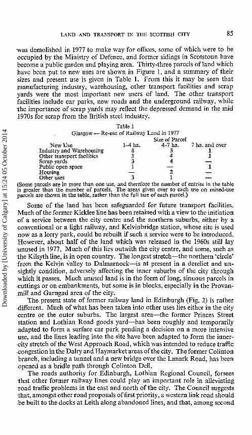
Railway lines, stations, marshalling yards, engine works and carriagesheds covered about four per cent of the area of the City of Glasgow in thelate 1950s and a smaller proportion of Edinburgh. Several hundred hectareswere released for other uses by the rail closures in the mid 1960s, amountingto more than one per cent of the area of Edinburgh and about two per centof that of Glasgow.
The subsequent fate of this land in Glasgow is shown in Figure 1. Muchof it has been taken over by other users, and this is especially true of largeblocks, such as the former stations, marshalling yards and sidings. Almostall such land has passed to some other central or local government user orgovernment-appointed body: the site of Buchanan Street station is nowoccupied by a 'bus station; St. Enoch station, which served as a car park,
Dow
nloa
ded
by [
Uni
vers
ity o
f C
alga
ry]
at 1
5:24
05
Oct
ober
201
4
*4 SCOTTISH GEOGRAPHICAL MAGAZINE
Fig. 1—Glasgow: Railways, Canals and Docks.
Dow
nloa
ded
by [
Uni
vers
ity o
f C
alga
ry]
at 1
5:24
05
Oct
ober
201
4
LAND AND TRANSPORT IN THE SCOTTISH CITY 85
-was demolished in 1977 to make way for offices, some of which were to beoccupied by the Ministry of Defence, and former sidings in Scotstoun havebecome a public garden and playing area. Thirty-three parcels of land whichhave been put to new uses are shown in Figure 1, and a summary of theirsizes and present use is given in Table 1. From this it may be seen thatmanufacturing industry, warehousing, other transport facilities and scrapyards were the most important new users of land. The other transportfacilities include car parks, new roads and the underground railway, whilethe importance of scrap yards may reflect the depressed demand in the mid1970s for scrap from the British steel industry.
Table 1Glasgow — Re-use of Railway Land in 1977
Size of ParcelNew Use
Industry and WarehousingOther transport facilitiesScrap yardsPublic open spaceHousingOther uses
l^tha.8331
—3
4-7 ha.344
—21
7 ha. and over11
—1
—
(Some parcels are in more than one use, and therefore the number of entries in the tableis greater than the number of parcels. The areas given over to each use on mixed-useparcels are shown in the table, rather than the full size of each parcel.)
Some of the land has been safeguarded for future transport facilities.Much of the former Kirklee line has been retained with a view to the initiationof a service between the city centre and the northern suburbs, either by aconventional or a light railway, and Kelvinbridge station, whose site is usednow as a lorry park, could be rebuilt if such a service were to be introduced.However, about half of the land which was released in the 1960s still layunused in 1977. Much of this lies outwith the city centre, and some, such asthe Kilsyth line, is in open country. The longest stretch—the northern 'circle'from the Kelvin valley to Dalmarnock—is at present in a derelict and un-sightly condition, adversely affecting the inner suburbs of the city throughwhich it passes. Much unused land is in the form of long, sinuous parcels in•cuttings or on embankments, but some is in blocks, especially in the Provan-mill and Garngad area of the city.
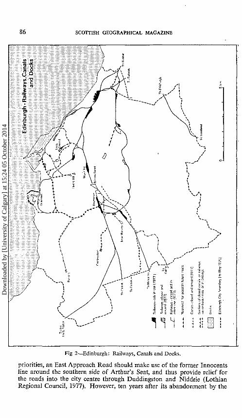
The present state of former railway land in Edinburgh (Fig. 2) is ratherdifferent. Much of what has been taken into other uses lies either in the citycentre or the outer suburbs. The largest area—the former Princes Streetstation and Lothian Road goods yard—has been roughly and temporarilyadapted to form a surface car park pending a decision on a more intensiveuse, and the lines leading into the site have been adapted to form the inner-city stretch of the West Approach Road, which was intended to reduce trafficcongestion in the Dairy and Haymarket areas of the city. The former Colintonbranch, including a tunnel and a new bridge over the Lanark Road, has beenopened as a bridle path through Colinton Dell.
The roads authority for Edinburgh, Lothian Regional Council, forseesthat other former railway lines could play an important role in alleviatingroad traffic problems in the east and north of the city. The Council suggeststhat, amongst other road proposals of first priority, a western link road shouldbe built to the docks at Leith along abandoned lines, and that, among second
Dow
nloa
ded
by [
Uni
vers
ity o
f C
alga
ry]
at 1
5:24
05
Oct
ober
201
4
86 SCOTTISH GEOGRAPHICAL MAGAZINE
Fig 2—Edinburgh: Railways, Canals and Docks.
priorities, an East Approach Road should make use of the former Innocentsline around the southern side of Arthur's Seat, and thus provide relief forthe roads into the city centre through Duddingston and Niddrie (LothianRegional Council, 1977). However, ten years after its abandonment by the
Dow
nloa
ded
by [
Uni
vers
ity o
f C
alga
ry]
at 1
5:24
05
Oct
ober
201
4
LAND AND TRANSPORT IN THE SCOTTISH CITY 87
railways much of the land in the north of the city remains derelict. Some ofthis is in narrow, sinuous parcels, in cuttings and surrounded by cemeteriesand parks which make access difficult, and other areas, such as Leith CentralStation, are covered by buildings which are probably of little value for non-iail uses.
io
Fig. 3—Glasgow New Roads.
Dow
nloa
ded
by [
Uni
vers
ity o
f C
alga
ry]
at 1
5:24
05
Oct
ober
201
4
88 SCOTTISH GEOGRAPHICAL MAGAZINE
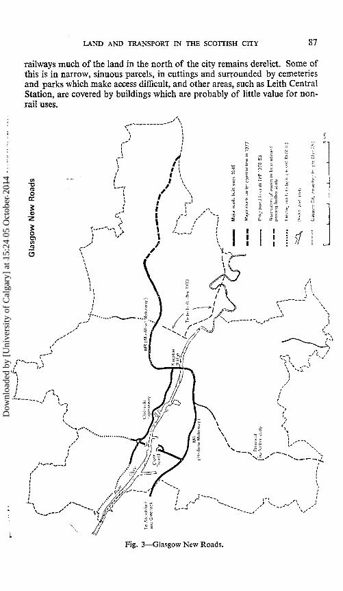
LAND FOR ROADS
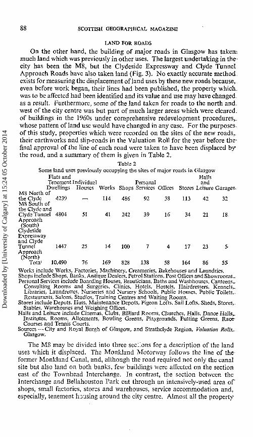
On the other hand, the building of major roads in Glasgow has takemmuch land which was previously in other uses. The largest undertaking in the-city has been the M8, but the Clydeside Expressway and Clyde TunnelApproach Roads have also taken land (Fig. 3). No exactly accurate method,exists for measuring the displacement of land uses by these new roads because,.even before work began, their lines had been published, the property which,was to be affected had been identified and its value and use may have changed.as a result. Furthermore, some of the land taken for roads to the north and.west of the city centre was but part of much larger areas which were cleared,of buildings in the 1960s under comprehensive redevelopment procedures,,whose pattern of land use would have changed in any case. For the purposes-of this study, properties which were recorded on the sites of the new roads,,their earthworks and slip-roads in the Valuation Roll for the year before the-final approval of the line of each road were taken to have been displaced bythe road, and a summary of them is given in Table 2.
Table 2Some land uses previously occupying the sites of major roads in Glasgow
Flats and HallsTenement Individual Personal andDwellings Houses Works Shops Services Offices Stores Leisure Garages-
M8 North ofthe Clyde 4239 — 114 486 92 38 113 42 32M8 South ofthe Clyde andClyde Tunnel 4804 51 41 242 39 16 34 21 18Approach(South)
ClydesideExpresswayand ClydeTunnel 1447 25 14 100 7 4 17 23 5̂Approach(North)
Tota' 10,490 76 169 828 138 58 164 86 55Works include Works, Factories, Machinery, Creameries, Bakehouses and Laundries.Shops include Shops, Banks, Antique Dealers, Petrol Stations, Post Offices and Showrooms.Personal Services include Boarding Houses, Beauticians, Baths and Washhouses, Canteens,.
Consulting Rooms and Surgeries, Clinics, Hotels, Hostels, Hairdressers, Kennels,.Libraries, Laundrettes, Nurseries and Nursery Schools, Public Houses, Public Toilets,.Restaurants, Salons, Studios, Training Centres and Waiting Rooms.
Stores include Depots, Huts, Maintenance Depots, Pigeon Lofts, Sail Lofts, Sheds, Stores,.Stables, Warehouses and Weighing Offices.
Halls and Leisure include Cinemas, Clubs, Billiard Rooms, Churches, Halls, Dance Halls,.Institutes, Rooms, Allotments, Bowling Greens, Playgrounds, Putting Greens, Race-Courses and Tennis Courts.
Sources —City and Royal Burgh of Glasgow, and Strathclyde Region, Valuation Rolls,.Glasgow.
The M8 may be divided into three sections for a description of the landuses which it displaced. The Monkland Motorway follows the line of the-former Monkland Canal, and, although the road required not only the canalsite but also land on both banks, few buildings were affected on the sectioneast of the Townhead Interchange. In contrast, the section between theInterchange and Bellahouston Park cut through an intensively-used area ofshops, small factories, stores and warehouses, service accommodation and,especially, tenement housing around the city centre. Almost all the property-
Dow
nloa
ded
by [
Uni
vers
ity o
f C
alga
ry]
at 1
5:24
05
Oct
ober
201
4
LAND AND TRANSPORT IN THE SCOTTISH CITY 89
xecorded in Table 2 stood on the site of this central section of the M8,including much of the St. George's Cross, North Street and Stobcrosschopping areas. Further west, the Renfrew Motorway took land from rail-way sidings, playing fields and allotments. The Clydeside Expressway also•displaced large numbers of tenement dwellings and shops, and used small•areas of former railway land and part of Victoria Park, while the approachroads to the Clyde Tunnel required the demolition of more than two hundredsound dwellings and fifty shops (Glasgow Corporation).
Plans for other major roads in the city have been severely pruned by thenew roads authority, Strathclyde Regional Council. Proposals for an inner-•city motorway box with spur motorways from it are not being pursued,•except for the line of the east flank of the box, which is still being reservedand the extension of the M74, in the form of a dual carriageway road, acrossland still occupied by the Clyde Iron Works and through areas of Dalmarnockwhich have already been cleared of dense tenement housing, to the LondonRoad at Bridgeton (Scotsman). On the other side of the city, the westward-extension of the Clydeside Expressway to Clydebank will require the demoli-tion of much tenement and shop property on the Dumbarton Road whichwas already in a run-down state in 1977, but the land-use demands of otherroad schemes within the built-up area will be small.
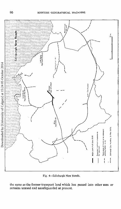
In Edinburgh, by contrast, much has been planned but little has beenachieved. With the exception of the West Approach Road the chief result ofthirty years of road proposals has been the deterioration of the area betweenthe Meadows, Holyrood Park and the Royal Mile as plans for, first, aNicolson Street bypass and, then, a Bridges Relief Road, followed by anEastern Link Road discouraged maintenance and development, and led to:much deterioration of property and some demolition. These plans have nowbeen abandoned, as have others for a Southern Link Road, Intermediate•Circular Route and South East Spur, releasing more than two thousandproperties from the threat of demolition and putting an end to any suggestionthat Edinburgh should have even part of a purpose-built inner ring road.The more modest suggestions of the new roads authority, which are shownin Figure 4, are now being debated. Those which the Regional Council•considers to be most immediately desirable are the continuation of WestApproach Road to the M8, thus providing a bypass for Corstorphine, the•outer ring road, the Leith Docks Approach Roads and Musselburgh Bypass.None of these would involve substantial demolition of existing buildings,but the ring roads around Edinburgh and Musselburgh would require land•at present in public open space and agriculture along much of their length.
SUMMARY
When all the changes in use and proposals for the re-use of former"transport land in the two cities are summarised it may be seen that there has"been little change in the proportion of the urban area which is used or is tobe used for transport. Over half of the land from which canal and rail"facilities have been withdrawn in the last twenty years has been or is intendedt o be re-used to provide new forms of transport, and, despite ambitiousproposals for transferring much land to urban motorways, the area whichlias actually been or is to be taken from non-transport uses is only about
Dow
nloa
ded
by [
Uni
vers
ity o
f C
alga
ry]
at 1
5:24
05
Oct
ober
201
4
90 SCOTTISH GEOGRAPHICAL MAGAZINE
Fig. A—Edinburgh New Roads.
the same as the former transport land which has passed into other uses orremains unused and unsafeguarded at present.
Dow
nloa
ded
by [
Uni
vers
ity o
f C
alga
ry]
at 1
5:24
05
Oct
ober
201
4

LAND AND TRANSPORT IN THE SCOTTISH CITY 91
A
DUND
EE
„
V)0)
t R
oul
Prim
an
•a
c
/ays
a
oo
if \r̂ \5" \
K C
I " o
/
\
197
land
icot
rV
J
i
\
\ ) >
;?q s/if
rout
es
Mo
torw
ay
Oth
er p
rim
ary
II
/—"io
n
y E
ler
cons
tr
30 1
Pla
nned
or
unc
i
' o-
rFig. 5
However, when seen in a wider context the impact of the new roads hasbeen substantial. The ease of movement in Glasgow has been increasedsignificantly, and through traffic between the Central Belt of Scotland andthe Clyde coast greatly assisted (Fig. 5). Without doubt, the costs of thisnew mobility have been high. More than three per cent of the city's dwellings
Dow
nloa
ded
by [
Uni
vers
ity o
f C
alga
ry]
at 1
5:24
05
Oct
ober
201
4
92 SCOTTISH GEOGRAPHICAL MAGAZINE
were demolished, several thousand people had to be rehoused, communitieswere disrupted and commuting distances increased. Many business premiseswere lost and many businesses, most of which were of a service rather thana manufacturing nature, ceased to trade. Perfectly sound buildings, including;some of architectural merit, were torn down (New Glasgow Society).
Moreover, the changes in land use in both cities have had the effect oftransferring a net balance of land into public ownership. The obligation onthe public corporations to offer unwanted land to central and local govern-ment and to other government-appointed bodies before releasing it on the:general market, and the need to ensure that areas which prove to be un-attractive to private buyers should not be allowed to decay to the extent thatthey become nuisances have led to the retention of much more than half of"the former transport land in public hands. At the same time more than aquarter of the land which has been or will be required for major new roads,will be acquired from private owners. Thus, a further increase has occurredin the area in the city which is in the direct control of government, and the-scope for the rest of society to express its wishes as to how land should be-allocated has been further restricted.
The system of offering land first to other public authorities and bodies-may not have resulted in a net benefit to the community. Very substantialdelays have occurred in the redevelopment of some major city-centre sites.which have remained in public ownership, especially the former Princes Streetand St. Enoch stations, to levels of land-use intensity which their situation,within the city would seem to be able to sustain, and these delays have not.persuaded other developers to take up the less attractive sites in the innersuburbs, such as the former railway land in Leith. It is to be hoped that this-will be borne in mind when decisions are made about the fate of the remaining,canals within the two cities and the disposal of the large areas of decaying,dockland on the upper Clyde.
Glasgow Corporation, Minutes of the Highways and Planning Committees 1956-1974.Lothian Regional Council, The Development of Transportation Policy: Edinburgh Area, 1977..New Glasgow Society, News, 1970.The Scotsman, 1st July 1975.
GRANTS FOR RESEARCH
It is announced that grants have been made as follows:20th International Geographical Congress Fund—M. G. Anderson, C. P. Green and N. Ste-phens, R. D. Knowles, A. T. O'Garra, K. Pye and S. T. Trudgill £100 each, T. Cannonand R. L. Jones and D. H. Keen £75.
Dudley Stamp Memorial Fund—A. T. O'Garra £100, S. M. Cunningham and A. A. Morrison£75 each, M. E. Wray £50.
Forms of application for the 1980 grants should be obtained from the Executive Secretary,The Royal Society, Cartlon House Terrace, London SW1Y 5AG. Details of grants will-be advertised in October.
Dow
nloa
ded
by [
Uni
vers
ity o
f C
alga
ry]
at 1
5:24
05
Oct
ober
201
4