land and rural development policy reforms in colombia: … · margarita varón usaid/colombia land...
TRANSCRIPT

Land and Rural Development Policy Reforms in
Colombia: The Path to Peace
Authors: Kevin Barthel, Vanessa Cespedes, Beatriz Salazar, Ricardo Torres,
Margarita Varón
USAID/Colombia Land and Rural Development Program (LRDP)
Presenting Author: Margarita Varón
Copyright 2016 by author(s). All rights reserved. Readers may make verbatim copies of this document
for non-commercial purposes by any means, provided that this copyright notice appears on all such copies.
Key Words: Peace Process, Land Policy, Restitution, Information Technology, Land Fund

2
I. INTRODUCTION
Land tenure insecurity inhibits the development of Colombia’s rural areas and agricultural
sector, prevents the government from addressing the country’s development challenges, and is
responsible for an armed conflict that devastated the country for over 50 years. High levels of
land informality prevent rural Colombians from overcoming poverty, and lack of formal land
ownership has exacerbated social conflict between communities, ethnic populations, businesses,
and rural citizens. Vulnerable populations—such as Afro-Colombian and indigenous people—
have experienced significant marginalization despite policy efforts that seek to acknowledge the
unique needs of this group. A strong differential approach and government commitment to
addressing the unique land challenges of these groups continues to be of the utmost
importance.
The government estimates that informality in land tenure falls somewhere between 20% and
59.5% in Colombia (lack of land information makes it difficult to pinpoint this figure). It is
believed that this percentage is likely an underestimate due to the fact that even registered property presents inconsistencies with real land tenure on the ground. Based on the quality of
life survey 2011, DNP estimates that at least 59.5% of the people who exercise relationships
over land do so informally.
The magnitude of the impact of the armed conflict on rural land has been substantial. The first
estimates compiled by the National Planning Department suggest that 352,847 families
abandoned their land during the years of conflict—often forcibly under duress—leaving behind
4,758,602 hectares of land.1 Three years after the Government implemented the Victims Law
—which seeks to protect the rights of the victims of armed conflict and recognize the injustices
they have suffered—the government of Colombia has received 87,1192 restitution claims
involving a total of 71,796 parcels accounting for 179,501 hectares of land.3
Although the figures on tenure informality, land abandonment, and dispossession are not exact,
it is abundantly clear that land informality in rural Colombia is a significant constraint to rural
development. This challenge can only be effectively addressed by developing a well-coordinated
institutional framework that is backed by strong public policies which facilitate land access for
the poorest of the poor: farmers and land-dependent communities that have been most
effected by the armed conflict.
Advancing land tenure security in Colombia will improve rural citizen access to credit and
technical assistance, which will grow agricultural productivity and promote economic
development in poor communities. A 2014 agricultural census showed that only 11% of farmers
had access to credit, and 9.6% production units received technical assistance.
Fortunately, over the past few years, the issues of land tenure and access have gained a
prominent position in the country's political and public agenda, as evidence by newly
1 This estimate is based on the declarations of those displaced. 2 Number as of January 7th 2016 3 National Restitution Unit. https://www.restituciondetierras.gov.co/estadisticas-de-restitucion-de-tierras

3
demonstrated political will to address the challenges facing Colombia’s countryside, and most
recently the partial peace agreements signed by the government and the Fuerzas Armadas
Revolucionarias de Colombia (FARC) in Havana, Cuba.
The government has demonstrated political will to transform the countryside through a new
comprehensive land policy which lays out three key initiatives:
(i) The Mission for the Transformation of the Colombian Countryside (Mision para la
Transformación del Campo);
(ii) Comprehensive Rural Reform (which has been included in the peace negotiations)
(iii) The inclusion of critical elements needed to increase land tenure security in the
National Development Plan 2014 – 2018.
These initiatives outline proposed government solutions to land challenges that will catalyze
rural transformation cross Colombia. Moving from the sphere of political dialogue to
operational implementation will take considerable effort and financial resources, which may need to be augmented by the donor community.
In an effort to support implementation of these proposed public policy reforms, this paper will
take an in-depth look at the following proposed policy instruments: (i) the policy frameworks
that support rural transformation, including Mission for Transformation of the Countryside,
Comprehensive Rural Reform, and the National Development Plan (ii) the identification,
clarification, and recovery of illegally awarded or obtained lands; and (iii) the design and
implementation of the Land Node.
I. FRAMEWORKS THAT SUPPORT TRANSFORMATIONAL RURAL REFORM
Mission for the Transformation of the Countryside
The Mission for the Transformation of the Countryside presents a comprehensive policy for
the social structuring of rural property (Ordenamiento Social de la Propiedad, or OSPR). The
OSPR policy outlines a series of processes needed to identify, clarify, consolidate, formalize, and
protect rural property rights, properly manage natural resources, and implement land access
policies that help narrow the rural-urban gap—thus promoting the well-being and prosperity of
rural inhabitants and communities.
The policy describes land tenure in Colombia as generally informal, disorganized, insecure,
improperly used, and managed without taking into account the social and productive context of
each territory; which has reduced both land access and the productive potential of land. The
policy describes state intervention on these issues as reactive and inconsistent, with weak
operational implementation. Consequently, individual tenure formality has historically been
achieved when an individual is able to initiate, drive, and essentially, attract state attention in
order to have their needs met.
The OSPR policy calls for a transformation of this historically ineffective approach in order to
set in motion more pragmatic public interventions through which public services are provided
through large-scale, focalized, operational strategies that facilitate the implementation of OSPR

4
on the ground throughout the country. The proposal calls for interventions with clear
objectives and specific resources allocated through approved plans that have a territorial focus.
In addition, the OSPR policy called for the creation of a National Land Agency. This agency was
established December 2015 and now has the authority to administer, deliver, and formalize
state lands, and promote land management throughout the national territory. As requested by
the RRI, a review of current land and agrarian processes was suggested, with a call to simplify
related legal frameworks and ensure they address the current needs of the rural sector. Special
initiatives, such as the creation of an agrarian jurisdiction/court, should be considered to
improve the judicial stage of proceedings related to the protection and definition of property
and land use rights.
However, it is important to recognize the difficulties inherent to the strategy of recovery of
state lands as included in the RRI, Mission para la Transformación del Campo. The OSPR policy
recommends that the recovery of 'illegally occupied lands', including the process, benefits,
consequences, and implications, be reviewed in detail. Lack of state presence created an environment conducive to colonization—the informal occupation of territory—is one of the
reasons the OSPR policy is necessary. However, aggressive plans to recover these lands could
result in the eviction of families that have occupied and used these parcels for decades, which
could fuel a new generation of conflicts. It is important to gather detailed information about the
realities that created conditions for ‘illegal occupation’ in order to prevent an outcome of
conflict. In this context, the policy recommends careful study of the cases and conditions that
may permit the state, in its capacity of land administrator, to recognize occupation, promote
the formalization of property rights as an effective mechanism for facilitating land access, and
reward those who have settled land in good faith and who are complying with the social
function of land.
Comprehensive Rural Reform
Comprehensive Rural Reform (RRI) is the first agreed-to point of the peace negotiations
between the Government and the FARC. This reform establishes the general criteria required
to address the conditions that drove conflict in Colombia, and reverse the effects of war. One
of the main drivers –of conflict in Colombia— although not the only one—is equitable access
to and use of land. The objective of RRI is to transform conditions of rural areas and create
conditions of wellbeing so that the country can start building stable and long-lasting peace.
Concerning land tenure the RRI objective is to democratize property and promote an equal
distribution of land. In order to achieve this objective, it proposes the following four actions.
First and in order to promote real access to land, the peace agreement includes the creation of
a land fund to identify and recover land that can be redistributed to those who do not have it,
or those who have an insufficient amount. Illegally acquired forfeited lands, illegally occupied
lands that have been recovered by the state, lands that are no longer considered to be part of
or classified as forest reserves, unexploited forfeited lands, lands donated to the fund, or lands
seized by the state due to their social interest or public utility in exchange for a corresponding
compensation will be fed into the land fund. As mentioned, there are a series of practical
difficulties associated with the implementation of the fund that are being analyzed in detail by
the Government.

5
Second is the mass formalization of small and medium rural properties. As per the agreement,
this is the means to protect rights and to prevent violence from being used to resolve or
minimize land related conflict. It also seeks to avoid dispossession. A commitment was made
that tenure on all lands will be formalized. To do this, the following measures have been
proposed (among others): putting in place legal, institutional, and operational reforms, designing
and implementing an integrated, systematic and massive formalization plan on a territorial basis,
providing formalization of property rights to small properties at no cost, and complementing
formalization efforts with measures to ensure that farms are productively viable.
Third is establishing an agrarian jurisdiction (court) with sufficient jurisdictional coverage to
provide efficient and effective justice in rural areas. This mechanism works in unison with
alternative conflict resolution mechanisms and provides the formal and last resort to resolve
disputes regarding property rights and land use rights. The agrarian jurisdiction is comprised of
several formal and informal courts, such as justices of the peace, conciliators, and mediators.
Fourth is the creation and modernization of a multipurpose cadaster in order to collect,
maintain, and make available accurate and up-to date information on the location,
ownership/occupation, value, and use of each parcel of land. This information will be linked with
the property registry to support legal certainty of property, a high-functioning and dynamic land
market, productive land use, and the equitable determination, administration, and collection of
property taxes. The cadaster is a key tool that connects the reality of land tenure with the
formal property registry, so that property rights protect and adequately reflect the land tenure
situation on the ground.
These actions are consistent with those outlined in Misión para la Transformación del Campo,
are explained in detail, and include information about the projects that need to be put in place
for their design and effective implementation.
The National Development Plan: 2014-2018
The National Development Plan (Law 1753), supports the government to meet the
commitments made by the state in the RRI described above, and adopts key elements of the
'Mission for the Transformation of the Countryside’s Public Policy’ as well as some of its
recommendations. To this end, the President used his extraordinary legislative powers to
create a new National Land Agency, which was legally established on December 7th, 2015. With
this action comes a new legal regime through which state-owned land can be provided to
vulnerable populations, and three measures that facilitate and streamline massive formalization
of rural property are provided: (i) the legal authorization for funding for massive formalization;
(ii) the implementation of a multipurpose cadaster as the informational base for formalization;
and (iii) the simplification of procedures to resolve and correct discrepancies between the
actual physical size and boundaries of land parcels and the legally registered description.

6
II. NATIONAL PLAN FOR THE CLARIFICATION AND RECOVERY OF
UNDULY OCCUPIED OR ILLEGALLY OBTAINED LANDS
The Colombian Constitution establishes that it is a duty of the state to provide progressive
farm workers4 with access to land ownership and other rural public utilities in order to
improve the income and quality of living of the rural population. Law 160/1994 sets forth
principles and procedures which grant rural citizens’ access to land programs offered by the
state. Priority is given to economically disadvantaged rural inhabitants of state-owned lands by
awarding them state lands (baldíos)5 based on the unit of measurement stipulated in the legal
framework known as the Family Farming Unit (UAF for the acronym in Spanish)6.
In the Colombian legal system, state-owned lands are public property classified in the category
of assignable fiscal assets.7 As with all public property, state owned land is imprescriptible and
cannot be seized or transferred; the only way to acquire its ownership is for the competent
authority to exhaust all the administrative procedures stipulated for this purpose.8
Consequently, they cannot be taken by individuals using statements of ownership contained in court rulings handed down by Colombian Judges.9
Notwithstanding the above, many rural citizens in recent years have turned to the judicial
branch to formalize their occupation of state-owned lands through ownership proceedings.
While these proceedings appear successful, they are expressly prohibited by Colombian law
and could have led to the misappropriation of approximately 1,202,36610 hectares of state land
by individuals.
This threatens public assets, a problem exacerbated by lack of state knowledge of the
boundaries or location of state-owned lands (because there is no inventory) let alone who is
4 These workers are understood as economically disadvantaged men and women who meet the requirements set forth in Law 160 and other
regulatory provisions, which in the case of titling state-owned lands (baldíos), are rural inhabitants over the age of 16, with a monthly salary
less than one thousand (1,000) per month, are not owners of other rural properties on national territory, and directly occupy and exploit two thirds (2/3) of the land surface requested in accordance with the suitability of the soil for at least five (5) years.
5 In Colombia, state-owned lands (baldíos) are understood as the properties located within the Nation's borders that have no owner, or have
been awarded and been returned to the State for legal reasons established in regulations. 6 A Family Farming Unit (UAF) is a basic agricultural, livestock, aquaculture or forest production unit whose extension, according to the
agroecological conditions of the area and with the proper technology, allows the family to make a living and have a capitalizable surplus that will assist in the creation of its equity.
7 Constitutional Court, Reporting Judge Carlos Gaviria Díaz, Ruling c-595 / 1995. 8 Article 65 of Law 160 / 1994 determines that the ownership of assignable state-owned lands (baldíos) can only be acquired by means of the
transfer of ownership by the State. It also points out that the occupants of state-owned lands (baldíos), are not the owners thereof in
accordance with the Civil Code, and as regards the awarding of these lands by the State, there is a mere expectation, which indicates the property is not susceptible to any other form of appropriation, such as the legal condition known as usucaption or the acquisition of ownership through uninterrupted possession.
9 One of the ways to acquire property is through the acquisition of ownership through uninterrupted possession, which operates in favor of
the person acting as the owner and master of a thing through the passage of time and under the conditions provided by law, filing petition with a Colombian Judge to declare him/her the owner thereof through ownership proceedings. This figure is grounded on the social function
of ownership and, in this sense, punishes the title holder of the asset by divesting his/her right for not having exercised ownership. On the subject of acquisition of ownership through uninterrupted possession of the assets, Article 375 (4) of the General Code of Procedure establishes that "The declaration of ownership is not applicable with regard to assets that are imprescriptible or are property of public law
entities". The last section of Article 17 of Law 1561 / 2012 establishes that in no case can the rulings on the declaration of ownership stand opposed to the Colombian Institute for Rural Development (Incoder for the acronym in Spanish) in its jurisdiction. The above prohibition of acquiring state-owned lands (baldíos) by means of the declaration of ownership is based on the precepts contained in the Fiscal Code adopted by Law 110 / 1912, particularly Articles 44 and 61, which expressly establishes that the land located within the borders of national territory
that have no other owner, are state-owned lands (baldíos) and as a result, belong to the State. Therefore, the ownership of the state-owned land (baldíos) cannot be acquired through uninterrupted possession, that is to say, they are imprescriptible.
10 Pedro Malagón, the Deputy Superintendent for the Protection, Restitution and Formalization of Lands, Presentation of Results, Bogotá D.C.,
October 19, 2015.

7
occupying them. In addition, administrative procedures for awarding or titling these properties
to agrarian reform beneficiaries, as well as those established for the recovery thereof, are
inefficient and extremely time-consuming. This has led to the need for a sound public policy
focused not only on legalizing these properties and on their identification and administration.
This is even more relevant by virtue of the historic peace negotiations with the Revolutionary
Armed Forces of Colombia (FARC) in Havana, where the first item agreed upon by the parties
is the creation of a Land Fund for the free distribution to rural citizens without land or with
insufficient land. Land within the fund is to be supplied by state-owned lands to be identified, as
well as the land recovered after being unduly occupied by third parties, making it a top priority
for the National Government in a possible post-conflict scenario. As stated before article 102
of the National Development Plan established a new legal regime through which state-owned
land can be provided to vulnerable populations, which is one of the first steps towards the
creation of the Land Fund established in the RRI.
This problem was made evident by the Constitutional Court through ruling T-488/2014, which emphasizes that the only way to acquire ownership is through the administrative procedures
stipulated for that purpose. According to the Court the ownership proceedings that breach the
actual legal framework is a problem that is threatening to extend quickly in several departments
in the country, affecting hundreds of thousands of hectares that by order of Colombian Judges
are illegitimately being stripped of their identify as public property11.
The High Court ordered the Colombian Institute for Rural Development (INCODER), which is
now going through settlement/liquidation proceedings, along with the Ministry of Agriculture
and Rural Development (MARD) and the Superintendent of Notaries and Records (SNR) to
identify state-owned lands awarded irregularly through ownership proceedings and adopt a
national plan for designing a process for identifying (including circumstances of time, method,
and place) misappropriated state-owned lands throughout the country, as well as actions for
their legal and material recovery.
In addition, the Colombian government has promoted regulatory initiatives to design and
implement the state-owned land inventory. This would optimize their management as well as
provide the state and its associates with legal security. Decree 1858/2015, under the auspices of
the Ministry of Justice and Law, establishes the procedure to assign and identify state-owned
lands by opening Land Title Registrations12 in favor of the nation.
Advances and achievements of the national plan for the clarification and recovery of
unduly occupied state-owned lands
In 2015, the entities called on to execute the orders given by the Constitutional Court—
INCODER, MARD and SNR—put in place a task force to follow the orders with the support of
the USAID Land and Rural Development Program (LRDP). This included the following.
11 Ruling T - -488 / 2014, Reporting Judge Jorge Iván Palacio, Constitutional Court, July 9, 2014, Bogotá. 12 Land title registrations are the instruments by which properties are legally identified. They contain all the information on the properties and
the transactions carried out involving them, and provide the legal status of the respective asset at any given point in time. Each land title
registration is a cadastral unit and any listings to be made will refer to this registration.

8
1. Identification of the nation's state-owned lands possibly misappropriated by
individuals through ownership proceedings.
The SNR entrusted the country's 193 Public Deed Registries (ORIP) with the responsibility of
identifying land title registrations opened on the properties acquired through ownership
proceedings throughout the national territory. This action identified 65,445 land title
registrations, 48,605 of which were rural properties, creating the baseline to identify the nation's
state-owned lands that were allegedly assigned irregularly through ownership proceedings
ordered by the High Court.
The SNR reviewed, analyzed and verified 48,605 land titles registered between August 1974
and June 2014 following criteria established by this agency. Of these, 29,020 land title
registrations, totaling approximately 1,202,366 hectares,13 were preliminarily classified as
possible state-owned lands that were misappropriated by individuals through ownership
proceedings. In addition it was found that 7,255 land titles registered had been awarded to
individuals who were favored by two or more ownership rulings, 1,745 cases involved lands
exceeding the limits of the UAF established by Law 160/1994, and 1,222 properties that were
allegedly state-owned lands were misappropriated by national or local government entities,
private companies and/or multinationals. This are only initial estimates and as has been stated
before, a careful review of data available is needed as the Government lacks reliable
information.
These results could indicate that the ownership proceedings could have become a mechanism
repeatedly used by individuals to evade the restrictions for awarding state-owned lands contained in the agrarian legislation, particularly those aimed at deconcentrating ownership and
achieving a more equitable land distribution. This exercise also identified the likely universe of
properties that have been misappropriated through ownership proceedings, and shown the
irregularities and inconsistencies in the handling of information by the ORIPs. The analysis
showed that one third of the land title registrations contained errors associated with the failure
to register the area, identification number and/or name of the awardee or final owner.
The work carried out by the SNR alone is not enough to begin legal and material recovery
proceedings of the properties identified. According to Colombian law any conflicts associated
with the ownership, use, and exploitation of rural lands must be settled by means of the
administrative proceedings set forth for this purpose in Law 160/1994 and regulated by Decree
1071/2015, which in the specific case, are those of the clarification of properties and the
recovery of unduly occupied state-owned lands.
2. Formulation of the national plan for clarification, recovery of unduly occupied state-owned lands (baldíos) and inventory of the nation's state-owned lands
13 This total comprises the areas listed in the land title registrations equivalent to the decimal metric system, which are square meters, square centimeters, square decameters, square hectometers, fanegadas and square yards. However, the records were found to contain "atypical" units of measurement, such as squares, blocks, cabuyas, cabuyadas, estancia, almudes, puchas, caballerías, cuarteron, matas, gdas, solares, and QM y TTS which complicate on-site verification and measurement.

9
Prior to its recent (December 7th, 2015) liquidation as a result of the National Development
Plan, INOCDER was the entity responsible for carrying out the administrative agrarian
proceedings mentioned above. Along with the institutions that make up the inter-institutional
task force14, it designed the methodology for the execution for clarification and recovery of
state-owned lands, and the design and implementation of the state-owned lands inventory and
land 18th, 2015, for its consideration and eventual approval.
This methodology consists of six activities to be developed in the short (1 year), medium (2-4
years) and long term (5+ years), and outlines the identification of the nation's state-owned
lands; the determination of applicable legal paths; the execution of pilot plans that will later be
replicable throughout the country; how to deal with the areas of national territory that have no
cadastral information; communication, training and community awareness strategies; and the
implementation of an interoperable information system that will facilitate its management and
make the nation's land inventory sustainable.
If the Government is to be consistent with the comprehensive public policy explained previously, pilots of the national plan for clarification and recovery should be implemented
through an integrated execution strategy. The objective of this integrated operational strategy is
to be efficient and to effectively derive public value from public investment. Individual or
scattered activities should be avoided and land issues should not be seen as separate or distinct
efforts.
The identification and recovery of state-owned lands by the Colombian Government involves
the exhaustion of the processes to clarify ownership in cases where there is uncertainty
regarding whether the validity of the property awarded from state assets; and the identification
of unduly occupied state-owned lands where titling is not possible from a legal, agronomic, and
cadastral standpoint and therefore, must be recovered and managed by the state.
The proceedings outlined in the above paragraph are defined in Title 19 of Decree 1071/ 2015,
as follows:
1) The agrarian process of Clarification from the Ownership Standpoint is to clarify the legal
situation of land ownership in order to identify whether or not these lands are state assets.
2) The agrarian process of Recovery of Unduly Occupied State-owned Lands, is intended to
recover and return to the state any state-owned lands that are unduly occupied by
individuals.
Successful execution of the proposed plan assumes that it will contribute to the implementation
of the state-owned land inventory that will enable the Colombian state to carry out effective
and rational management of state lands to ensure their productive use. In addition, this is one of
the sources of the Land Fund provided in item one of the Havana peace agreement.
14 The inter-institutional committee of the National Plan for the Clarification and Recovery of State-owned lands (baldíos) is made up of the
Ministry of Agriculture and Rural Development (MARD), the Colombian Institute for Rural Development (Incoder), now going through settlement proceedings, the Agustin Codazzi Geographic Institute (IGAC), the Superintendence of Notaries and Records (SNR) and the
Rural Agrarian Planning Unit (UPRA).

10
Challenges for the implementation of the national plan for the clarification and recovery
of state-owned lands
The implementation of the National Plan for the Clarification and Recovery of State-owned
Lands involves different challenges for the Colombian state, which include the following.
1. New institutional structure/entity: This is a time of institutional change with relation to the structures/entities that will execute Colombia’s rural land policy. INCODER, the
entity initially responsible for the formulation and execution of the National Plan for the
Clarification and Recovery of Unduly Occupied State-owned land, is currently going
through a liquidation process. This process will likely create delays in the execution of
the national plan, while the new entity, the National Land Agency, which absorbs the
land related responsibilities of INCODER, is operationally established and is ready to
carry out its technical, legal, and administrative responsibilities.
2. Identification of the state-owned lands: One of the main challenges for Colombian institutions is the dispersion of administrative responsibilities and lack of coordination
between entities, which, many times, do not have a common objective. This leads to
breakdowns in information sharing, which is segmented across different entities that do
not have a unified information system. Consequently, the task of identifying state-owned
land entails the collection, standardization, debugging and analysis of multiple sources of
information including the cadastral databases of IGAC, INCODER for the information of
the state-owned land titling and agrarian processes, the National System of Protected
Areas, and the SNR. In addition, there are areas of the national territory that have no
cartographic information for the physical identification of the property. This implies the
coordinated implementation of the multi-purpose cadaster methodology along with the
sweep of every parcel that the National Land Agency will execute on determined
geographical zones progressively until the whole country is covered. This also means
that agencies that provide services needed by the National Land Agency would have to
work in a collaborative way to provide them.15
3. Application of the agrarian legislation: The identification and recovery of state-owned lands involves the execution of complex administrative procedures that increase
the time provided by National Government to comply with the orders of the
Constitutional Court. These procedures are even more extensive in cases where the
state-owned lands have been appropriated through court rulings. This is because these
rulings are binding and, although they are not opposable to the entity in charge of state-
owned land management, they cannot be rendered null and void by the competent entity
of the executive branch by exhausting the administrative procedures. Consequently, the
Colombian State has resorted to a strategy of petitions for the protection of
fundamental rights for each of the court rulings in order to nullify the court orders and
carry out the administrative procedures to recover the lands.
15 The Colombian State is encouraging the implementation of the national cadaster with a multi-purpose approach, understood as a system that
not only has physical property information, but also the information aimed at contributing to the legal security of the right to property
ownership, the strengthening of local tax revenues, land management and social and economic planning.

11
The legal instruments for the material recovery of the properties are also unclear and
often ineffective, requiring new regulations that would provide the National Land Agency
(ANT) with sufficient authority for the effective recovery of the state-owned lands that
are ultimately identified and cannot be awarded to their occupants because they do not
meet the requirements laid down in the Law.
4. State responsibility: In addition to the legal effects of court rulings mentioned above, they represent a high risk for the state from a pecuniary standpoint since they have been
handed down by Colombian Judges. The beneficiaries thus can resort to the courts and
file suit against the Colombian state for failures in the service incurred by the judicial
branch and request payment for damages suffered. In addition, the judges involved in the
rulings could be investigated and punished as a result of handing down illegal rulings,
which would likely lead to their dismissal, creating instability and loss of confidence in
the courts.
5. Social impact: Execution of the Plan on national territory could also trigger conflicts between the state and civilian population subject to eviction from the unduly occupied
properties, which could cause endless political and social strife and repercussions in
areas subject to recovery. Consequently, the Colombian state is joining efforts to carry
out the tasks entrusted with the focus of generating the least impact possible on rural
workers who often in good faith took possession of state-owned lands without knowing
the procedures that had to be carried out to do so.
III. DESIGN AND IMPLEMENTATION OF THE LAND NODE
The Land Node is a technological platform that will permit—for the first time ever in
Colombia—the interoperability of information systems between state entities. Once fully
implemented, it will facilitate automatic information exchange among entities that manage
information related to the land restitution process, as set forth in Law 1448/2011 (the Victims
and Land Restitution Law) and the Online Government Policy of the Colombian Ministry of
Information and Communication Technologies.
But the Land Node is more than a model of technological innovation. It is expected to facilitate transformational institutional reform by strengthening the information systems of state
institutions, as well as the agreements, conventions, and protocols that ensure the sharing of
information among the Colombian institutions involved in land governance. Once functional, it
will ensure the secure and efficient exchange of information produced and managed by various
state entities, increase government accountability and transparency, and reduce the time and
cost associated with land restitution and formalization programs.
As has been said, this along with other implementation projects should be considered
strategically in an integrated view to put in place a comprehensive public policy on land tenure
available. Land Node is a great opportunity for land governance and represents at the same
time an important challenge to avoid duplicity with the national land system conceived in the
National Development Plan on article 104.

12
The Victims and Land Restitution Law (also known as the Victims Law) generated a change in
Colombia's recent social and political history. The law not only recognized the armed conflict
and the rights and needs of victims of war but also acknowledged the need to strengthen the
capacity of state institutions to implement the policy.
The main challenge to achieving restitution, demonstrated in the last four years of
implementation of the law, is the physical and legal identification of the properties subject to
claims. This has required institutions to respond to requests for clear, accurate, and updated
information. However, several structural problems have stood in the way of data availability and
quality. One particular challenge has been Colombia’s outdated cadaster, which is riddled with
information discrepancies, missing information, limited inventory of state land, poor
organization, and weak systems for the effective exchange of information between multiple
entities. Delays in the delivery of information have caused the restitution process to take an
average of more than 220 days in the first phase (known as the administrative stage), which, by
law, should not exceed 90 days, and 230 days in the final phase (known as the judicial stage),
which, by law, should not exceed four months.
The Victims Law orders public entities at the national and regional levels to organize a
comprehensive information system that will allow multiple agencies to easily access and share
information with each other and provide documentation required for the restitution process in
a more timely manner. The Land Node initiative is thus proposed as a solution for the
integration of information systems managing cadastral data, property register, inventory of state
lands, and the registration, assistance, and reparation of victims.
Context and Regulatory Framework
The Land Node is based on articles 76, 153, and 161 of the Victims Law. Article 76 requires
that the Land Restitution Unit have access to all databases on victims of land takeovers or
forced displacement and have real-time information-exchange capabilities. Article 153 calls for
the creation of a national information network that provides the National System for Victim
Assistance and Comprehensive Reparations (SNARIV) with quick and accurate national and
regional information; it also requires the SNARIV to guarantee the interoperability of
information systems for the registration and reparation of victims. Finally, article 161 establishes
that one of the main objectives of the SNARIV is to provide support for the implementation of
an information platform that enables land-related entities to carry out their legally mandated
monitoring and follow-up duties.
Entities Comprising the Land Node
The Land Node is made up of eight entities: the Land Restitution Unit, the Superior Judicial
Council, the SNR, IGAC, INCODER (which is in the process of being absorbed by the new
National Land Agency), the Directorate for Comprehensive Action against Antipersonnel
Mines, the Special Administrative Unit for the Assistance and Comprehensive Reparation of
Victims, and the Attorney General's Office.
The Ministry of Information and Communications Technologies (MINTIC) provides the
infrastructure for the Land Node’s interoperability and sets and enforces data protocols and
standards. MINTIC also ensures the availability of economic resources for the Land Node and
13
provides its certification and seal of excellence. Importantly, it has identified the Land Node as
one of 24 projects of Colombia’s Road Map for Online Government, which prioritizes the online
services that most Colombian citizens and institutions need.
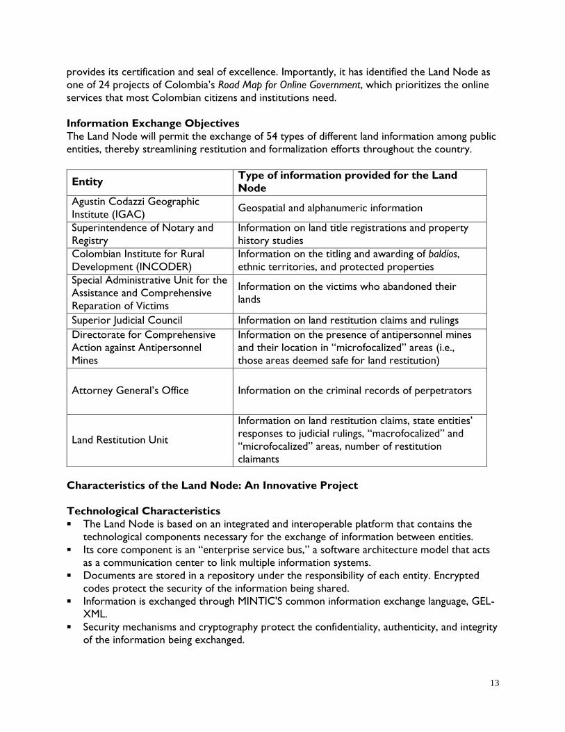
Information Exchange Objectives
The Land Node will permit the exchange of 54 types of different land information among public
entities, thereby streamlining restitution and formalization efforts throughout the country.
Entity Type of information provided for the Land
Node
Agustin Codazzi Geographic
Institute (IGAC) Geospatial and alphanumeric information
Superintendence of Notary and
Registry
Information on land title registrations and property
history studies
Colombian Institute for Rural
Development (INCODER)
Information on the titling and awarding of baldíos,
ethnic territories, and protected properties
Special Administrative Unit for the
Assistance and Comprehensive
Reparation of Victims
Information on the victims who abandoned their
lands
Superior Judicial Council Information on land restitution claims and rulings
Directorate for Comprehensive
Action against Antipersonnel
Mines
Information on the presence of antipersonnel mines
and their location in “microfocalized” areas (i.e.,
those areas deemed safe for land restitution)
Attorney General’s Office Information on the criminal records of perpetrators
Land Restitution Unit
Information on land restitution claims, state entities’ responses to judicial rulings, “macrofocalized” and
“microfocalized” areas, number of restitution
claimants
Characteristics of the Land Node: An Innovative Project
Technological Characteristics
The Land Node is based on an integrated and interoperable platform that contains the
technological components necessary for the exchange of information between entities.
Its core component is an “enterprise service bus,” a software architecture model that acts
as a communication center to link multiple information systems.
Documents are stored in a repository under the responsibility of each entity. Encrypted
codes protect the security of the information being shared.
Information is exchanged through MINTIC'S common information exchange language, GEL-
XML.
Security mechanisms and cryptography protect the confidentiality, authenticity, and integrity
of the information being exchanged.

14
The system tracks the identification of the individuals who are using it, what type of
information they are accessing, and when they are requesting the information. This allows
for an audit of how the system is being used.
Security protocols allow for different levels of authorization among entities and individuals.
Unlike a system that merely consolidates information, the Land Node allows for the
exchange of information based on web services that are independent from each other; in
other words, information does not have to be stored anywhere. The only thing that is saved
is the traceability (that is, who is requesting what from the system) in order to generate
reports and statistics.
Phases of Development
The Land Node will be fully functioning after the completion of four phases. The first phase
involves a portrayal of the project’s scope for each entity. The second involves analysis and
design. The third phase involves implementation. The last phase is deployment.
Figure 1: Team in Charge of the Project
Project Sustainability
Each entity will sign an inter-institutional agreement that has been agreed on among all
entities in order to ensure the exchange, use, confidentiality, and security of the
information.
The construction and implementation of the Land Node will be guided and supported by
the interoperability framework proposed in MINTIC’s Online Government strategy. This
includes a set of principles and policies that will guide the political, legal, and organizational
efforts of the entities involved, as well as standards and protocols for sharing information
securely and effectively.
A technical subcommittee of the SNARIV will be responsible for the monitoring,
assessment, and maintenance of the Land Node.
The Land Node is a web-based platform that links the databases or information systems of land
entities in order to allow them to exchange information in real time, as prescribed by law. One
of its most innovative features is the fact that it is not an information system through which data

15
are consumed and shared, or a database that centralizes information; rather, the information
that is exchanged on the platform is stored and administrated by each entity.
By placing technology at the service of the victims of land displacement, the Land Node
presents an opportunity for Colombia to solve the current informational bottlenecks suffered
by a range of land-related entities and to strengthen accountability in governance.
The Land Node’s success will be measured by looking at the extent to which the times and
costs of land restitution and formalization processes are reduced. This success will depend
largely on each institution’s efforts to adapt its internal processes and to strengthen
technological and regulatory tools for the Land Node’s implementation.
IV. CONCLUSIONS
The current state of land tenure is one of the factors that have contributed to the persistence
of the Colombian conflict for more than forty years. RRI and the Mission for the
Transformation of the Countryside jointly propose significant policy measures to transform the OSPR. The National Development Plan and the decrees issued by the President have taken the
first steps towards its implementation.
However, a detailed review of the commitments made in the RRI and the recommendations in
Mission for the Transformation of the Countryside bring to light the need to move forward in
the design and implementation of additional measures such as: (i) the design and issuance of a
new legal framework that allows the National Land Agency to meet its commitments; (ii) the
design and creation of an agrarian jurisdiction; (iii) a participatory process to feed back into this
policy framework; and (iv) a new operational framework that facilitates the Government's
execution of the OSPR in massive supply processes and with economies of scale that begin with
the implementation of a true multipurpose cadaster, among others.
Adequate and careful planning and the efficient implementation of this package of measures will
be the condition for these land-related adjustments to contribute towards meeting the
ambitious goals set forth by the government, which are moving in the right direction towards
building long-lasting and stable peace in Colombia.