kirklees surface water management plan · pdf filesurface water flooding is generally more...
TRANSCRIPT
Kirklees Surface
Water Management
Plan
An evidenced statement on the surface water flood risk in Kirklees and a
delivery plan for reduction of the risk across the district
2011
Tom Ghee
Kirklees Council
1/2/2011
Kirklees Surface Water Management Plan
Kirklees Council + Environment Agency + Yorkshire Water
2
Leave blank for back to back printing

Kirklees Surface Water Management Plan
Kirklees Council + Environment Agency + Yorkshire Water
3
Acknowledgements
This report follows the guidelines set down in the ―Surface Water Management Plan Technical Guidance‖ published March 2010 by Defra.
The Integrated Urban Drainage (IUD) pilot projects carried out to test and inform the guidance document, have been a useful resource in determining a practical approach to produce an effective SWMP for Kirklees. In particular, the plans produced by Richmond and Warrington have suggested processes that have influenced and guided the Kirklees SWMP.
Use of the Information in the Report
As Lead Local Flood Authority (LLFA), Kirklees Council has a duty to develop, maintain, apply and monitor a strategy for local flood risk management. The LLFA must specify objectives to manage flood risk and suggest measures to achieve those objectives. The LLFA has a responsibility to consider the flood risk management functions that it may exercise to reduce risk.
In support of the aim of a general reduction of flood risk across the district, the Council will prioritise investigations and works identified in this Plan to the best of its abilities, based on perceived and evidenced risk and within limited resources.
The indications of flood risk in the report are high level and based on incomplete information. A level of subjectivity has been used in assessing relative flood risk and the results will be used to prioritise future, more robust, investigations and assessments which will, hopefully, lead to reliable measures of risk. Consequently, it is not appropriate to apply the information and recommendations in this report at a local, property level.

Kirklees Surface Water Management Plan
Kirklees Council + Environment Agency + Yorkshire Water
4
Leave blank for back to back printing
Kirklees Surface Water Management Plan
Kirklees Council + Environment Agency + Yorkshire Water
5
Contents
Acknowledgements ............................................................................................................... 3
1 Executive Summary ....................................................................................................... 7
2 Glossary ...................................................................................................................... 11
3 Introduction .................................................................................................................. 15
3.1 Surface Water Management Plans in Context ....................................................... 15
3.2 How does the SWMP fit with other policies? ......................................................... 16
3.3 Drivers for a systematic approach to Flood Risk Management (FRM) ................... 19
3.4 What is a Surface Water Management Plan? ........................................................ 20
3.5 What is Surface Water Flooding? .......................................................................... 20
3.6 What are the factors that cause and influence surface water flooding? ................. 21
3.7 The Interaction between Surface Water Flooding and Fluvial (River) Flooding ..... 22
4 The Study Area for the SWMP ..................................................................................... 25
4.1 Definition of the scope of the Plan ......................................................................... 25
4.2 Characteristics of the Area .................................................................................... 25
4.3 General Flooding Characteristics and Issues ........................................................ 25
4.3.1 Pluvial Flooding/ Smaller Watercourse Flooding ............................................ 25
4.3.2 Pluvial Flooding/ Sewer Flooding ................................................................... 26
4.4 Recent Flood History ............................................................................................ 27
4.5 Predicted Future Flooding ..................................................................................... 28
4.6 Relative Flood Risk between Kirklees and other Local Authority Areas ................. 29
4.7 The Effect of Climate Change on Future Flooding ................................................ 29
5 Objectives of the Plan .................................................................................................. 31
5.1 Key Objectives ...................................................................................................... 31
5.2 The Approach to the Plan ..................................................................................... 31
5.3 Structure of the Report .......................................................................................... 33
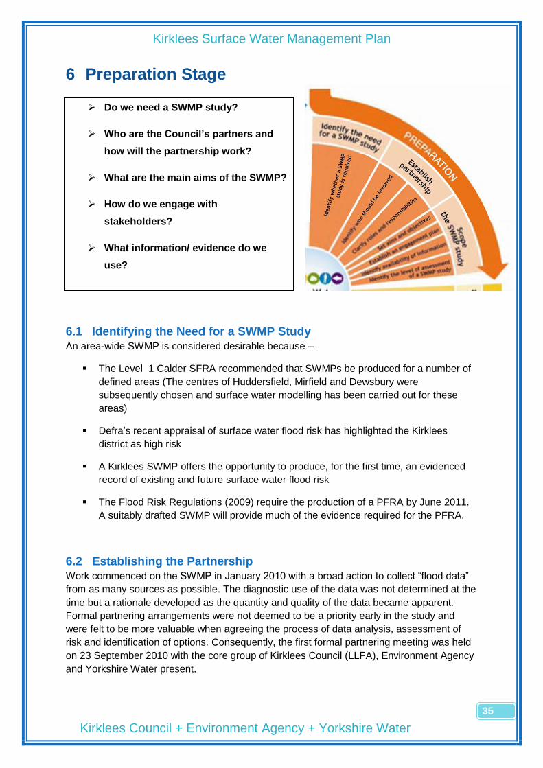
6 Preparation Stage ........................................................................................................ 35
6.1 Identifying the Need for a SWMP Study ................................................................ 35
6.2 Establishing the Partnership ................................................................................. 35
6.3 Scope of the Study................................................................................................ 38
6.3.1 Aims and Objectives ...................................................................................... 38
6.3.2 Stakeholder Engagement............................................................................... 38
6.3.3 Sources of Information ................................................................................... 39
6.3.4 The Level of the SWMP Assessment ............................................................. 39
7 Risk Assessment Stage ............................................................................................... 41

Kirklees Surface Water Management Plan
Kirklees Council + Environment Agency + Yorkshire Water
6
7.1 Collating Information ............................................................................................. 41
7.2 Undertaking the Strategic Assessment ................................................................. 43
7.2.1 Method of Assessment .................................................................................. 43
7.2.2 Results of Assessment .................................................................................. 44
7.3 Mapping and Communicating the Risk .................................................................. 45
7.3.1 Mapping ......................................................................................................... 45
7.3.2 Communicating .............................................................................................. 45
8 Options Stage .............................................................................................................. 49
8.1 Identifying Measures ............................................................................................. 49
8.2 Priorities for Assessment ...................................................................................... 50
8.3 Method of Assessment ......................................................................................... 50
9 Implementation and Review ......................................................................................... 53
9.1 The Extent and Severity of Surface Water Flood Risk ........................................... 53
9.2 Immediate Priorities .............................................................................................. 54
9.2.1 Verification of the Prioritisation Process ......................................................... 55
9.3 The SWMP Action Plan ........................................................................................ 56
9.4 Presentation and Publication of Results ................................................................ 57
9.5 Reviewing the Action Plan .................................................................................... 57
Appendix 1 .......................................................................................................................... 59
Risk Assessment Scoring Methodology ........................................................................... 59
Risk Assessment Scores ................................................................................................. 60
Appendix 2 .......................................................................................................................... 71
The Spread of Surface Water Flood Risk across Kirklees................................................ 71
Appendix 3 .......................................................................................................................... 79
Assessment Report Template ......................................................................................... 79
Appendix 4 .......................................................................................................................... 81
Priority Measures Template ............................................................................................. 81

Kirklees Surface Water Management Plan
Kirklees Council + Environment Agency + Yorkshire Water
7
1 Executive Summary
In June 2007, widespread extreme flooding was experienced in the UK. The Government
review of the 2007 flooding, chaired by Sir Michael Pitt recommended “Local Surface Water
Management Plans (SWMPs) … coordinated by local authorities, should provide the basis
for managing all local flood risk.”
The Governments guidance document for SWMPs, ―Surface Water Management Plan
Technical Guidance‖, defines a SWMP as:
a framework through which key local partners with responsibility for surface water
and drainage in their area, work together to understand the causes of surface water
flooding and agree the most cost-effective way of managing surface water flood risk
a tool to facilitate sustainable surface water management decisions that are evidence
based, risk based, future proofed and inclusive of stakeholder views and preferences
a plan for the management of urban water quality through the removal of surface
water from ―combined‖ systems and the promotion of SUDS
As a demonstration of its commitment to SWMPs as a structured way forward in managing
local flood risk, Defra announced an initiative to provide funding for the highest flood risk
authorities to produce SWMPs. Kirklees Council was one such authority, receiving a grant of
£100k towards its plan, with a delivery date of April 2011.
Recent legislation, The Flood and Water Management Act 2009 and The Flood Risk
Regulations 2010, place new responsibilities on Councils to understand, coordinate and
manage local flood risk, creating the new role for Kirklees Council of Lead Local Flood
Authority (LLFA).
The legislation, for the first time, creates a clear distinction between responsibility for main-
river flooding, managed by the Environment Agency, and flooding from other sources
(Surface Water Flooding), managed by the LLFA.
The SWMP process allows discretion to adopt a level of analytical detail appropriate to the
quality and quantity of the data available. Consequently, reflecting the scarcity of information
available on which to make judgements on risk and priorities for mitigation of the risk, the
Kirklees SWMP is strategic and area wide. It has the broad aim of evidencing the general
flood risk across the whole district, identifying areas of higher flood risk requiring further,
more detailed investigation.
Kirklees is the 11th largest district council out of 348 (Population of around 400,000) and 3rd
largest metropolitan council in area (400km2). The main population centres are Huddersfield
(125,000), Dewsbury (57,000) and Batley (45,000), with a further 10, or so, small towns (5-
20,000). Around 40% of the area is heavily urbanised with 60% rural in character, of which
half is in the Pennine hills.

Kirklees Surface Water Management Plan
Kirklees Council + Environment Agency + Yorkshire Water
8
With respect to water resources, Kirklees has 27 large reservoirs in the Pennines, managed
by the local Water and Sewerage Company, Yorkshire Water. There are approximately
100km of enmained river, managed by the Environment Agency, and unrecorded, but
substantial, lengths of culverted and open minor watercourses. The main rivers in the district
are the rivers Colne and Calder flowing to the river Aire, which drains around 85% of the
area, and the river Dearne flowing to the river Don, draining the remaining 15%. Average
annual rainfall figures for the district range from 1800mm at the Pennine headwaters to
800mm in Huddersfield, compared with an average across England of 950mm.
Surface water flooding is generally more prevalent in the hillier, rural, less developed south
side of the district. The settlements along the Dearne, Holme, Colne and Woodsome Valleys
are concentrated along the rivers and suffer the consequences of rapid surface water runoff
from the uplands and fields on the steep valley sides. Formal drainage systems are sparse,
often unrecorded and consequently, poorly maintained. The industrial heritage of the larger
settlements as textile centres has left a historical legacy of stone culverts carrying surface
water through areas of high residential occupation. Information on the location, condition and
connectivity of the culvert systems is piecemeal but is a significant factor in understanding
and reducing flood risk in those locations.
The large settlements to the centre and north of the district, Huddersfield, Dewsbury and
Batley, have significant networks of public sewers, owned and maintained by Yorkshire
Water, with less evidence of smaller culverted watercourses remaining in those areas. It is
likely that the traditional means of draining surface water via watercourses has been
gradually replaced by the developing public sewer system carrying rainwater in both surface
water and combined sewers.
There has been recent significant local summer flooding in the summers of 2002, 2004,
2007 and January 2008
The 2007 floods flooded up to an estimated 500 properties across the district and were
described by many residents as the worst in living memory. The flooding was widespread
across the district but hotspots occurred around Ravensthorpe, Liversedge, Cleckheaton,
Chickenley, Mirfield, Milnsbridge, Brockholes, New Mill, Denby Dale, Scissett and Clayton
West.
The 2007 events demonstrated that disruptive and damaging levels of flooding are
unpredictable in nature but increasingly likely to occur. Much of the future flood risk is likely
to be associated with surface water rather than from rivers and, as such, the mechanisms
need to be understood by Local Authorities to allow them to fulfil their roles as LLFA‘s.
Following the 2007 floods, the Environment Agency produced maps that identified areas
susceptible to surface water flooding following severe rainfall. The maps were used in the
assessment of relative flood risk to determine the allocation of future funding for local flood
risk management and are a useful indication of the scale and relative risk of surface water
flooding in Kirklees:
Kirklees is one of 149 LLFA‘s in England, ranking 55th in terms of general flood risk

Kirklees Surface Water Management Plan
Kirklees Council + Environment Agency + Yorkshire Water
9
Excluding Counties and London Boroughs, Kirklees‘ ranks 7th behind Hull,
Birmingham, Brighton, Doncaster, Leeds and Leicester, in terms of the flood risk to
be managed by the LLFA.
15,000 properties in the district are at risk from surface water flooding and 12,000
from main river flooding
The Kirklees SWMP provides an evidence base for understanding surface water flood risk
across the district. A district-wide, high-level, low-detail assessment of relative surface water
flood risk has been carried out to provide a foundation for future, more detailed assessment
work, targeted at the areas where the risk is highest. The SWMP includes the following:
Development of a formal drainage asset recording system for all the surface water
systems in the district
Development of a flood incident recording system to build up an understanding of
where flood risk is located
Representation of the asset and incident information in a graphical format to allow
improved visibility and easy cross-referencing of the data
An assessment of local surface water flood risk using the above data, EA surface
water maps, topographic/demographic information and site surveys
Representation of the relative surface water flood risk across the district in a format
that is understandable and accessible by the general public
A prioritised programme for future detailed investigation of the higher risk areas
A suite of measures that could be employed to mitigate the risk in the higher risk
areas
A partnership approach has been taken to the SWMP, with the Environment Agency and
Yorkshire Water engaged as principal partners in the production of the plan. Information on
drainage assets, incidents and predictions of the scope and severity of future flooding have
been collected through the partnership and represented on the Councils GIS system for
ease of understanding, analysis and presentation of flood risk.
An assessment of the risk from surface water flooding has been carried out on a 500m
square grid across the district, ranking areas on relative flood risk. Risk factors include
critical infrastructure (schools, hospitals, transport routes etc), residential and commercial
property density and the presence of historical flood incidents, coincident with the location of
predicted flooding.
The results of the assessment highlight around 200 ―squares‖, or areas, where the risk from
surface water flooding could be significant and future, more-detailed investigation work could
be beneficial. The areas are spread around the district but concentrations occur around
Slaithwaite, Ravensthorpe, Dewsbury, Liversedge and the A62 Leeds Road corridor at
Deighton.
Kirklees Surface Water Management Plan
Kirklees Council + Environment Agency + Yorkshire Water
10
The strategic approach to local surface water flood management is in a process of
development and the recent European legislation, The Flood Risk Regulations 2010, impose
a duty on Lead Local Flood Authorities to follow a structured approach to understanding,
publicising and reducing surface water flood risk in their districts. There are clear parallels
between the Preliminary Flood Risk Assessment (PFRA), required by the Regulations, and
the SWMP process, followed by Kirklees.
The Council‘s current legal obligations lie mainly with the Flood Risk Regulations and these
will direct immediate work. The SWMP provides an evidence base to inform the PFRA
required by the Regulations.
The Action Plan for the SWMP includes a programme of further investigations of those areas
identified as at high risk from surface water flooding with an indication of the level of Kirklees
Council resources required to deliver the actions.
Kirklees Surface Water Management Plan
Kirklees Council + Environment Agency + Yorkshire Water
11
2 Glossary
Annual Exceedance Probability (AEP) Catchment Catchment Flood Management Plan (CFMP) Chance of flooding Critical infrastructure Department for Environment, Food and Rural Affairs (Defra) Designing for Exceedance DG5 Register Environment Agency Environment Agency Flood Zones Exceedance flows
The chance of a flood of a given size happening in any one year eg 1 flood with a 1% AEP will happen, on average, once every 100 years A surface water catchment is the total area that drains into a river or other drainage system A strategic planning tool through which the Environment Agency works with other key decision-makers within a river catchment to identify and agree policies for sustainable flood risk management. The chance of flooding is used to describe the frequency of a flood event occurring in any given year, e.g. there is a 1 in 100 chance of flooding in this location in any given year. This can also be described as an annual probability, e.g. a 1% annual probability of flooding in any given year. (See AEP)
Infrastructure which is considered vital or indispensable to society, the economy, public health or the environment, and where the failure or destruction would have large impact. This would include emergency services such as hospitals, schools, communications, electricity sub-stations, Water and Waste Water Treatment Works, transport infrastructure and reservoirs. The UK government department responsible for policy and regulations on the environment, food and rural affairs Designing for Exceedance is an engineering philosophy or approach which aims to plan for and manage flows which are larger than the designed capacity of infrastructure during rainfall events. An example of designing for exceedance would be the use of car parks to store water during flood events. A Water and Sewerage Company (WaSC) held register of properties which have experienced sewer flooding (either internal or external flooding) due to hydraulic overload, or properties which are ‗at risk‘ of sewer flooding more frequently than once in 20 years. The Environment Agency was established under the Environment Act 1995, and is a Non-Departmental Public Body of Defra. The Environment Agency is the leading public body for protecting and improving the environment in England and Wales today and for future generations. The organisation is responsible for wide ranging matters, including the management of all forms of flood risk, water resources, water quality, waste regulation, pollution control, inland fisheries, recreation, conservation and Navigation of inland waterways. It will also have a new strategic overview for all forms of inland flooding Flood zones on the maps produced by Environment Agency providing an indication of the probability of flooding (from rivers and the coast) within all areas of England and Wales. Excess flow that appears on the surface once the capacity of the underground drainage system is exceeded
Kirklees Surface Water Management Plan
Kirklees Council + Environment Agency + Yorkshire Water
12
Flood Hazard map Flood Risk Management Plan Flood Risk Regulations Flood Risk map Flood and Water Management Act Floods Directive Fluvial Flooding Future Water Integrated Urban Drainage (IUD) Pilots Local Development Framework (LDF) Local Resilience Forums (LRF)
A map which identifies flood risk areas and shows – a) the likely extent (including water level or depth) of possible floods, b) the likely direction and speed of flow of possible floods, and c) whether the probability of each possible flood occurring is low, medium or high. A plan for the management of a significant flood risk. The plan must include details of – a) objectives set by the person preparing the plan for the purpose of managing the flood risk, and b) the proposed measures for achieving those objectives Legislation that transposed the European Floods Directive in 2009 A map showing in relation to each flood risk (a) the number of people living in the area who are likely to be affected in the event of flooding, (b) the type of economic activity likely to be affected in the event of flooding, (c) any industrial activities in the area that may increase the risk of pollution in the event of flooding, (d) any relevant protected areas that may be affected in the event of flooding, (e) any areas of water subject to specified measures or protection for the purpose of maintaining the water quality that may be affected in the event of flooding, and (f) any other effect on— (i) human health, (ii) economic activity, or (iii) the environment (including cultural heritage). The Flood and Water Management Act clarifies the legislative framework for managing surface water flood risk in England. The EU Floods Directive came into force in November 2007 and is designed to help Member States prevent and limit the impact of floods on people, property and the environment. It was transposed into English law in December 2009 by the Flood Risk Regulations. Resulting from excess water leaving the channel of a river and flooding adjacent land The Government‘s water strategy for England; Future Water was published in February 2008. This strategy sets out the Government‘s long-term vision for water and the framework for water management in England. The 15 Defra funded studies which ran from January 2007-June 2008 to test new approaches to working in partnership to improve management of urban drainage. A non-statutory term used to describe a folder of documents which includes all the local planning authority‘s Local Development Documents (LDDs). The local development framework will also comprise the statement of community involvement, the local development scheme and the annual monitoring report. LRFs are multi-agency forums, bringing together all organisations which have a duty to co-operate under the Civil Contingencies Act, and those involved in responding to emergencies. They prepare emergency plans in a co-ordinated manner.

Kirklees Surface Water Management Plan
Kirklees Council + Environment Agency + Yorkshire Water
13
Main River Making Space for Water Ordinary watercourse Pitt Review Planning Policy Statements (PPS) Pluvial flooding Resilience measures Resistance measures Riparian owners Risk Strategic Flood Risk Assessment (SFRA) Surface water flooding Sustainable Drainage Systems (SuDS) UK Climate Impacts Programme (UKCIP) Urban Creep Water Framework Directive (WFD)
Main Rivers are watercourses marked as such on a main river map. Generally main rivers are larger streams or rivers, but can be smaller watercourses. MSfW, launched in 2004, outlines the Government strategy for the next 20 years to implement a more holistic approach to managing flood and coastal erosion risks in England. An ordinary watercourse is any other river, stream, ditch, cut, sluice, dyke or non-public sewer which is not a Main River. The local authority has powers for such watercourses. An independent review of the 2007 summer floods by Sir Michael Pitt, which provided recommendations to improve flood risk management in England These set out the Government‘s national policies on different aspect of planning. The policies in these statements apply throughout England and focus on procedural policy and the process of preparing local development documents. PPS25 sets out policy to ensure that flood risk is taken into account at all stages of the planning process to avoid inappropriate development in areas at risk of flooding and direct development away from areas at highest risk. ‗Pluvial‘ flooding (or surface runoff flooding) is caused by rainfall and is that flooding which occurs due to water ponding on or flowing over the surface before it reaches a drain or watercourse. Resilience measures are designed to reduce the impact of water that enters property and businesses, and could include measures such as raising electrical appliances Resistance measures are designed to keep flood water out of properties and businesses, and could include flood guards for example. A riparian owner is someone who owns land or property adjacent to a watercourse. A riparian owner has a duty to maintain the watercourse and allow flow to pass through his land freely. In flood risk management, risk is defined as the probability of a flood occurring x consequence of the flood A SFRA provides information on areas at risk from all sources of flooding. In this context, surface water flooding describes flooding from sewers, drains, groundwater, and runoff from land, small water courses and ditches that occurs as a result of heavy rainfall. A sequence of management practices and control measures designed to mimic natural drainage processes by allowing rainfall to infiltrate and by attenuating and conveying surface water runoff slowly compared to conventional drainage. UKCIP was established to co-ordinate scientific research into the impacts of climate change. In 2002 UKCIP released climate change scenario data, which was updated in 2009 The change of permeable areas within the urban environment to impermeable areas. Typical types of urban creep are the creation of patios, paving the front gardens to create hard standing parking areas or house extensions. A European Community Directive (2000/60/EC) of the European Parliament and Council designed to integrate the way water bodies are managed across Europe. It requires all inland and coastal waters to reach ―good status‖ by 2015 through a catchment-based system of River Basin Management Plans.

Kirklees Surface Water Management Plan
Kirklees Council + Environment Agency + Yorkshire Water
14
Leave blank for back to back printing
Kirklees Surface Water Management Plan
Kirklees Council + Environment Agency + Yorkshire Water
15
3 Introduction
3.1 Surface Water Management Plans in Context
The Government‘s national strategy for flood and coastal erosion risk management, Making
Space for Water (MSfW), set out a range of approaches to ensure that flood risk would be
managed more effectively in the future by adopting holistic, sustainable and systematic
methods. Surface water flood risk in urban areas, arising from inadequacies in drainage
systems was a particular concern, with recognition that the physical and institutional
complexities of the systems made it difficult to plan improvements to reduce flood risk. MSfW
recognised that urban drainage solutions have not always been as cost effective,
sustainable, adaptable or robust as they might have been had a more integrated approach
been adopted.
In 2007, therefore, Defra instigated a series of 15 pilot studies to examine various aspects of
Integrated Urban Drainage (IUD). The pilots assessed the development of partnerships, data
sharing, modelling approaches to surface water flood risk assessment, mitigation measures
and surface water management in large, new developments. In June 2007, widespread
extreme flooding was experienced in the UK, which highlighted that intense rainfall events
can occur anywhere and the need for all stakeholders to work in partnership to improve the
understanding and management of flood risk. Informed by the IUD Pilots and the summer
flooding, Defra, through its Future Water Strategy, set out its intentions to use Surface Water
Management Plans (SWMP) as the vehicle to deliver IUD management. The Government
review of the 2007 flooding, chaired by Sir Michael Pitt, reiterated this approach.
Recommendation 18 of his report states “Local Surface Water Management Plans, as set
out in PPS25 and coordinated by local authorities, should provide the basis for managing all
local flood risk.” (See Section 3.5)
In its response to the Pitt review, the Government confirmed its support for the SWMP
approach in high risk areas and outlined the broader intention for local authorities to take a
leadership role in local flood risk management.
In October 2008, Defra asked for expressions of interest from local authorities to carry out
―first edition‖ SWMPs to test the emerging guidance on a range of approaches in a range of
authorities. 6 SWMPs were carried out and the plans were published in spring 2010.
Many of the general recommendations within the Pitt Review have been carried through to
the Flood and Water Management Act (FWMA) 2010 which received royal assent in April
2010, assigning significant new duties for local authorities as Lead Local Flood Authorities
(LLFA). The responsibilities around understanding and communicating local flood risk,
coordinating actions amongst partners and determining priorities for action can all be
developed through a SWMP.
As a further demonstration of its commitment to SWMPs as a structured way forward in
managing local flood risk, Defra announced an initiative, prior to the commencement of the
Act, to provide funding for the 77 highest risk authorities to produce SWMPs. Kirklees
Council was one such authority, receiving a grant of £100k towards its plan, with a delivery
date of April 2011.

Kirklees Surface Water Management Plan
Kirklees Council + Environment Agency + Yorkshire Water
16
3.2 How does the SWMP fit with other policies?
The SWMP fits within the existing national and local policy framework, as follows:
Nationally
The SWMP can be used to coordinate and strategically plan the drainage provision in all
new developments where piecemeal actions are inefficient and do not support consistent
ownership and maintenance regimes for sustainable drainage systems (SuDS). In
addition the SWMP can also provide a framework for the management of water quality
(e.g. the control of discharges from combined sewer overflows, surface water drainage
outfalls, sustainable drainage systems and the urban surface generally). Solutions which
can address both flood and pollution risk have dual benefits, and can contribute to
fulfilling improvements and compliance in ecology, water quality and habitats required
under the Water Framework Directive (WFD).
The SWMP will provide understanding of the mechanisms of surface water flooding and
propose mitigation measures, which can provide the evidence base to inform Preliminary
Flood Risk Assessments and fulfil the requirement for Flood Risk Management Plans
under the Flood Risk Regulations (2009)
The Flood and Water Management Act (2010) requires Lead Local Flood Authorities to
develop strategies for local flood risk management for their areas. The SWMP can make
an important contribution to inform the development of this strategy and identifying ways
to implement it
Planning Policy Statement 25 (PPS25) sets out how new development should not
increase flood risk. The SWMP will inform local planning authorities about the areas at
risk from surface water flooding
Locally
The Calder Strategic Flood Risk Assessment was completed in November 2008 and
delivers an assessment of general flood risk across the Calder catchment in Kirklees,
Calderdale and Wakefield.
o Calder SFRA (Section 6.6) – “Limited modelling of surface water flooding has been
carried out in 3 higher-risk locations in Kirklees (Huddersfield, Dewsbury and Mirfield)
and flood maps have been produced for 1 in 100 and 1 in 1000 events for these
locations. The maps indicate many significant areas vulnerable to surface water
flooding outside EA River Flood Zone 3, which require more detailed investigation.‖
o Calder SFRA (Section 8.3) – “SWMP concepts are embedded in the Governments
new Water Strategy, Future Water, setting out a vision for more effective drainage of
surface water, in order to deal with the dual pressures of climate change and housing
development.
In order to achieve this, SWMPs should:

Kirklees Surface Water Management Plan
Kirklees Council + Environment Agency + Yorkshire Water
17
Map and quantify surface flows and drainage with sufficient detail to enable local
as well as strategic flooding problems to be tackled;
Produce a delivery plan that clarifies responsibilities and then directs resources at
tackling surface water, prioritising areas at greatest risk first (See Section 7);
Influence local planning policy such that new development occurs primarily in
areas of low surface water flood risk or where flood risk can be managed
effectively, making use of sustainable drainage solutions where appropriate; and
Be periodically reviewed, possibly including independent scrutiny of planning and
resource decisions to gauge progress in tackling the most serious problems.‖
The Calder Catchment Flood Management Plan was completed in July 2010 and
provides a strategic overview of FRM in the catchment. The catchment covers
approximately 85% of the Kirklees district.
o Calder CFMP – Table 3.1 records flood incidents caused by surface water flooding
in Marsden and Huddersfield in June 2000, in Mirfield in October 2000 and across
the whole district in June 2007.
o Section 3.43 confirms the general lack of understanding of surface water flood risk –
―Further understanding of the spatial distribution of surface water flood risk is
needed.‖
o Table 6.2 summarises the flood mechanisms in the catchment and the risks
associated with them.
Colne, Holme and Fenay Beck
Overtopping of the river and fluvial systems, incapacity of the sewerage, culvert and drainage infrastructure and sheet runoff and rapid runoff.
2,291 properties;
3,882 people;
over £1.7 million damages to property;
major road networks;
gas and electricity assets;
1 CoMAH site;
1 sewage treatment works;
environmentally designated sites.
Spen
Overtopping of the river and fluvial systems, incapacity of the sewerage, culvert and drainage infrastructure.
722 properties;
1,139 people;
significant economic and agricultural damages;
road network;
15 gas and electricity assets.
Mid Calder
Overtopping of the river and fluvial systems, exceedence of sewer capacity.
128 properties;
25 people;
over £1 million damages;
road and rail network
health facilities;
environmentally designated sites.
Table 6.2

Kirklees Surface Water Management Plan
Kirklees Council + Environment Agency + Yorkshire Water
18
o Table 7.6 indicates short term actions for surface water management
Action Outcome Lead organisation
Indicator
Work in partnership with the LLFA to reduce the risk of flooding from surface water. Carry out detailed studies in areas identified as at ‗significant risk‘ in the preliminary flood risk assessment.
Working in partnership to reduce surface water flood risk within the policy unit a long term prioritised plan of action will be developed to reduce the risk of flooding from this source. Further detailed understanding of the risk this source of flooding poses will ensure that future strategic flood risk management plans and development documents take the risk of surface water into account.
Lead Local Flood Authority
Kirklees Metropolitan Borough Council.
long term costed programme of works;
prioritised plan of action is developed;
no. of properties flooded by surface water.
Table 7.6
The Don Catchment Flood Management Plan was completed in July 2010 and
provides a strategic overview of FRM in the catchment. The catchment covers
approximately 15% of the Kirklees district.
o Don CFMP – Section 3.4.3 confirms the lack of information available for risk from surface water flooding – ―We have limited information on surface water flooding. Heavy rain can lead to both river and surface water flooding and historically reports have not differentiated between these sources. Estimates suggest that in June 2007, 70% of the properties flooded in the Yorkshire and Humberside regions were as a result of surface water. Locations within the catchment appear to be at higher risk from surface water flooding, especially as a result of development in the floodplain.‖
o Don CFMP - Section 6.4.4 - The preferred policy for the Upper Don, including the Upper Dearne valley villages is ―Policy decision has been determined as storage options within the policy unit provide the long term vision and opportunity for the area. This however is based on a large geographical area. Specific flood risk issues, such as those in the villages of Denby Dale, Scissett and Clayton West, will be taken into account in localised studies.”

Kirklees Surface Water Management Plan
Kirklees Council + Environment Agency + Yorkshire Water
19
Process chart showing relationships between SWMPs and other plans and policies
Evidence Strategy/ Policy/ Legislation Delivery
National CFMP's (Calder & Don) Water Framework Directive EA Capital Works
Programme
EU Floods Directive
SFRA (Calder) PPS 25
Surface Water Maps (EA) Floods and Water Management Act
(2010)SuDs Manual
Flood Risk Maps (EA) YW Investment Plans
Flood Risk Regulations (2009)
Flood Incident Records
(Yorkshire Water)
Local Development Framework Kirklees Council
Investment Plans
Local Flood Incident Records
(Kirklees)
Local Flood Risk Assessments New Developments
Surface Water Management Plan
3.3 Drivers for a systematic approach to Flood Risk Management (FRM)
National FRM policies are directed to take account of climate change implications and the
availability of funding to be able to invest in the provision of sustainable flood risk
management. This includes avoidance, substitution and mitigation through land use
planning, having regard to flooding from all sources (not just main rivers) and improving and
maintaining flood defences where justified. Key policies and initiatives affecting the
application of FRM include:
Making Space for Water Strategy (2005) – Confirms the Government‘s strategic
direction for Flood and Coastal Erosion Risk Management over a 20 year period. The
aim of the strategy is to manage sustainability, manage flood risk and ensure the
social and economic benefits from growth and development
Catchment Flood Management Plans – Produced by the Environment Agency

Kirklees Surface Water Management Plan
Kirklees Council + Environment Agency + Yorkshire Water
20
Planning policy PPS25 – Development and Flood Risk (2006) – Enabling Planning
Authorities to make appropriate and timely decisions that deliver sustainable planning
by reducing flood risk to and from new development
Learning Lessons from the 2007 Floods – An independent review by Sir Michael
Pitt
Climate Change Prediction, Defra (UKCP09) – Providing information on inevitable
climate change to help adaptation to a changing climate
3.4 What is a Surface Water Management Plan?
Surface Water Management Plans (SWMP) are referred to in Planning Policy Statement
PPS25 (Development and Flood Risk) as ―a tool to manage surface water flood risk on a
local basis by improving and optimising coordination between relevant stakeholders‖.
SWMPs build on Strategic Flood Risk Assessments (SFRA) and provide the vehicle for local
organisations to develop a shared understanding of local flood risk, including setting out
priorities for action, maintenance needs and links into local development frameworks and
emergency plans.
The Governments guidance document for SWMPs, ―Surface Water Management Plan
Technical Guidance‖, expands the scope of the plan to include the following:
A framework through which key local partners with responsibility for surface water
and drainage in their area work together to understand the causes of surface water
flooding and agree the most cost-effective way of managing surface water flood risk
To facilitate sustainable surface water management decisions that are evidence
based, risk based, future proofed and inclusive of stakeholder views and preferences
To coordinate and plan the drainage provision in large new developments where
piecemeal actions are inefficient, reducing surface water flood risk downstream
A framework for the management of urban water quality through the removal of
surface water from ―combined‖ systems and the promotion of SUDS
3.5 What is Surface Water Flooding?
Surface water flooding describes flooding from surface water sewers, drains, small
watercourse and ditches that occurs during heavy rainfall in urban areas. It includes:

Kirklees Surface Water Management Plan
Kirklees Council + Environment Agency + Yorkshire Water
21
Pluvial flooding: flooding as a result of high intensity rainfall when, water is ponding
or flowing overground before it enters the drainage network or watercourse, or
cannot enter because the network is full to capacity
Groundwater flooding: where groundwater is defined as water emanating from below the ground
Sewer flooding: flooding which occurs when the capacity of underground sewer
systems are exceeded either through lack of hydraulic capacity or restricted outfall, a
blockage in the sewer or failure of mechanical/electrical apparatus
Flooding from Ordinary watercourses: flooding which occurs as a result of the
capacity of the watercourse being exceeded. (Ordinary watercourses are those
managed by the local authority which are not designated as Main River by the
Environment Agency)
Overland flows: flooding resulting from surface-water run-off from both developed
and undeveloped land
It does not include:
Fluvial flooding: flooding as a result of the capacity of the Main Rivers being
exceeded and the excess surface water leaving the channel, flooding adjacent land
or property
Flooding from the catastrophic failure of reservoirs, ponds and canals
Flooding from foul sewers
3.6 What are the factors that cause and influence surface water
flooding?
The Pitt Review listed several factors that can cause and influence the likelihood of surface
water flooding:
Intensity of rainfall: rainwater drains away naturally over long periods of time, but if
rain falls in intense bursts the drainage system may be unable to cope. The
probability of this type of intense rainfall occurring in the future is likely to increase
due to climate change.
Location of rainfall: the direction of travel of surface water is directly influenced by
the topography of an area. Small changes in the location of rainfall can have a
significant impact on where the water ends up.
Kirklees Surface Water Management Plan
Kirklees Council + Environment Agency + Yorkshire Water
22
Capacity and condition of the sewer and drainage system: this can affect the rate
at which rainwater can drain away.
Type of surface material: the permeability of surface material affects the amount of
runoff. Urban areas are more susceptible to surface water flooding than rural areas
because they are characterised by a significant quantity of impermeable areas.
Saturation of the ground: if the ground is saturated, or even too dry, any rain that
falls will be converted into runoff.
3.7 The Interaction between Surface Water Flooding and Fluvial (River)
Flooding
The floods of 2007 demonstrated the gaps and overlaps in understanding the interaction of
drainage networks and relevant responsibilities, and the mechanisms of failure.
Recommendations for improving understanding formed much of the substance of the
subsequent Pitt report.
Whilst the public and media perception was that the majority of flooding was as a result of
rivers bursting their banks, the post-flood review carried out by the EA attributed 70% of
property flooding in Yorkshire and Humber to surface water flooding ie flooding as a result of
overland surface water run-off being unable to enter drainage systems or rivers that were full
to capacity.
In Kirklees, there were isolated incidents of fluvial flooding where rivers overtopped, eg the
River Spen at Liversedge and the River Dearne at Clayton West and Scissett, but the
majority of property flooding was caused by either surcharging surface water systems or the
Fluvial (River) flooding is defined as flooding occurring as a result of water leaving a
river channel as a result of lack of capacity in the channel, either through overtopping of
the river bank/flood bank or as a result of breaching of the flood bank.
Responsible Authority - The Environment agency is responsible for managing flooding
from main rivers ie those significant rivers designated by the Agency as ―main‖ river.
Surface Water Flooding has been defined previously in Section 3.5.
Responsible Authority - The recent Floods and Water Management Act 2010 created a
new duty for Local Authorities, in their capacity as LLFA, to investigate all significant
flooding incidents and allocate responsibility for action as appropriate. Responsibility for
action is shared between Local Authorities, Water Companies and landowners.
Kirklees Surface Water Management Plan
Kirklees Council + Environment Agency + Yorkshire Water
23
inability of those systems to discharge freely into main rivers because of high river levels and
submerged outfalls.
During extreme rainfall events, it will often be the case that both fluvial and surface water
flooding occur during the same event. It is extremely difficult to quantify the individual effect
of each type of flooding but this is largely irrelevant to those people suffering flooding, who
are interested in the impact rather than the cause.
The LLFA has a responsibility to investigate all flooding incidents (as defined in Section 3.5)
and allocate responsibility for further action as appropriate. Close and clear working
relationships with partners and stakeholders will be essential to achieve efficient resolution
of problems.
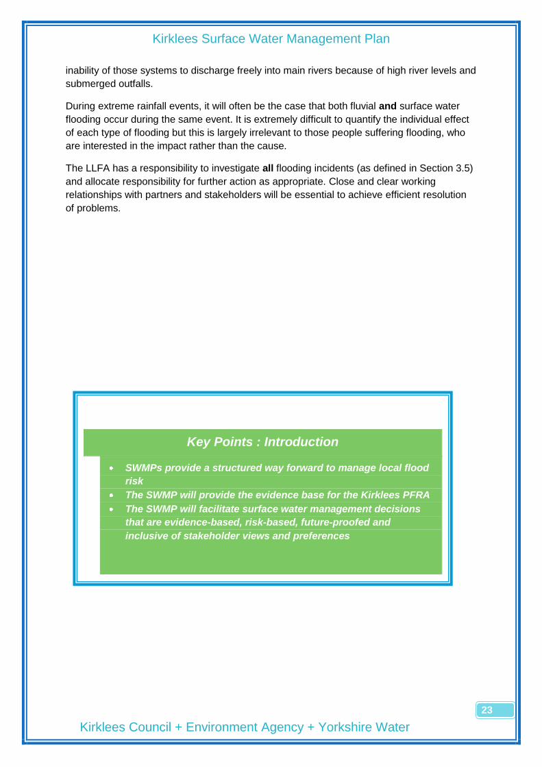
Key Points : Introduction
SWMPs provide a structured way forward to manage local flood
risk
The SWMP will provide the evidence base for the Kirklees PFRA
The SWMP will facilitate surface water management decisions
that are evidence-based, risk-based, future-proofed and
inclusive of stakeholder views and preferences

Kirklees Surface Water Management Plan
Kirklees Council + Environment Agency + Yorkshire Water
24
Leave page blank for back to back printing

Kirklees Surface Water Management Plan
Kirklees Council + Environment Agency + Yorkshire Water
25
4 The Study Area for the SWMP
4.1 Definition of the scope of the Plan
Anecdotal evidence from several significant flood events in the last decade (2002, 2004,
2007 and 2008) has illustrated that surface water flood risk in the district is widespread and
varied. The mechanisms of flooding are often complex and the Council‘s historic limited
investment in Flood Risk Management (FRM) has resulted in poor drainage asset and flood
incident records, making decisions on further action difficult.
The SWMP process allows discretion to adopt a level of analytical detail appropriate to the
quality and quantity of the data available. Consequently, reflecting the scarcity of information
available on which to make judgements on risk and priorities for mitigation of the risk, the
decision has been made to carry out an area-wide SWMP. The SWMP has the broad aim of
evidencing the general flood risk across the whole district, identifying areas of flood risk
requiring further, more detailed investigation.
4.2 Characteristics of the Area
Kirklees is a unitary council in West Yorkshire bounded by Calderdale, Bradford, Leeds,
Wakefield, Barnsley, Derbyshire and Oldham. In terms of size, it is the 11th largest district
council out of 348 (Population of around 400,000) and 3rd largest metropolitan council in
area (400km2). The main population centres are Huddersfield (125,000), Dewsbury (57,000)
and Batley (45,000), with a further 10, or so, small towns (5-20,000). Around 40% of the area
is heavily urbanised with 60% rural in character, of which half is in the Pennine hills. 1
With respect to water resources, Kirklees has 27 large reservoirs in the Pennines, managed
by the local Water and Sewerage Company, Yorkshire Water. There are approximately
100km of enmained river, managed by the Environment Agency, and unrecorded, but
substantial, lengths of culverted and open minor watercourses. The main rivers in the district
are the rivers Colne and Calder flowing to the river Aire, which drains around 85% of the
area, and the river Dearne flowing to the river Don, draining the remaining 15%. Average
annual rainfall figures for the district range from 1800mm at the Pennine headwaters to
800mm in Huddersfield, compared with an average across England of 950mm.2
4.3 General Flooding Characteristics and Issues
4.3.1 Pluvial Flooding/ Smaller Watercourse Flooding
Kirklees is dominated by 2 main river systems, the River Calder to the North of the district
and the River Dearne to the South, both rivers having their headwaters in the Pennines and
both ultimately flowing to the Humber estuary.
In the upper reaches of the Calder‘s tributaries, valleys are generally narrow and steep-
sided and consequently, flood zones are narrow. Existing development is mostly housing,
1 Kirklees Council, Factsheets 2010,
http://www.kirklees.gov.uk/community/statistics/factsheets/factsheets.shtml 2 Environment Agency, Calder Catchment Flood Management Plan July 2010, page 54
Kirklees Surface Water Management Plan
Kirklees Council + Environment Agency + Yorkshire Water
26
commercial or small areas of light industry. Flood defences are typically discontinuous with
flood walls in a mixed condition, offering low standards of flood protection.
In the downstream catchment between Huddersfield and Dewsbury, the floodplain broadens
and land-use includes large areas of heavy industry and housing within high flood risk zone.
Flood defences generally offer a higher level of protection.
The upper reaches of the Dearne above Clayton West are fairly steep and respond quickly
to rainfall. The industrial textile heritage of the area, resulting in recent residential
conversions of riverside mills, and the general high density of residential development in the
valley bottom leave a sizeable part of the local community at risk of flooding. There is little
historical evidence of river flooding from breached defences or overtopping but the main
issue appears to be flooding resulting from submerged outfalls to the river.
Surface water flooding is generally more prevalent in the hillier, rural, less developed south
side of the district. The settlements along the Dearne, Holme, Colne and Woodsome Valleys
are concentrated along the rivers and suffer the consequences of rapid surface water runoff
from the uplands and fields on the steep valley sides. Formal drainage systems are sparse,
often unrecorded and consequently, poorly maintained. The industrial heritage of the larger
settlements as textile centres has left a historical legacy of stone culverts carrying surface
water through areas of high residential occupation. Information on the location, condition and
connectivity of the culvert systems is piecemeal but is a significant factor in understanding
and reducing flood risk in those locations.
The large settlements to the centre and north of the district, Huddersfield, Dewsbury and
Batley, have significant networks of public sewers, owned and maintained by Yorkshire
Water, with less evidence of smaller culverted watercourses remaining in those areas. It is
likely that the traditional means of draining surface water via watercourses has been
gradually replaced by the developing public sewer system carrying rainwater in both surface
water and combined sewers.
The Ravensthorpe community, south west of Dewsbury, suffers an unusual form of surface
water flooding. Whilst the majority of the area lies in the highest fluvial flood risk zone, there
are no recent records of flooding from the rivers Calder and Spen, which have their
confluence in Ravensthorpe. However, there have been several recent episodes, most
notably in 2007, when high river levels restrict the free discharge of watercourses and public
sewers, causing the drainage systems to ―back-up‖, flooding the basements of the many
hundreds of Victorian terrace properties characteristic of the area. Social pressures in the
community are such that the majority of basements are now used as living space, with the
related consequence of damage and disruption to the inhabited rooms.
4.3.2 Pluvial Flooding/ Sewer Flooding
Yorkshire Water owns much of the combined and surface water sewers in the region. Sewer
systems are currently designed not to flood in a 1:30 year return period design storm. This
does not include accommodating flows from exceptional and high magnitude rainfall events.
During extremely wet weather, the rainfall may exceed current design criteria. Such events
can result in exceedance of the hydraulic capacity of the sewer thus increasing the risk of

Kirklees Surface Water Management Plan
Kirklees Council + Environment Agency + Yorkshire Water
27
flooding. One of the most recent occurrences of this type of event was the flooding
experienced in June 2007.
There are some known sewer related flooding issues within the Kirklees catchment.
However, overall sewer performance is satisfactory. Yorkshire Water is working with Kirklees
Council, the Environment Agency and other parties to better understand the interaction of
the networks and provide improvements that will help further reduce the risk of flooding.
4.4 Recent Flood History
The evidence base for this SWMP plan is gathered from the last 10 years, utilising the
available council recorded flood incidents and recently gathered drainage asset information.
It seems appropriate to consider the consequences of severe flood events during that same
period when carrying out the risk assessment
There has been recent significant local summer flooding in the summers of 2002,
2004, 2007 and January 2008
The 2007 floods flooded up to an estimated 500 properties across the district and
were described by many residents as the worst in living memory. The flooding was
widespread across the district but hotspots occurred around Ravensthorpe,
Liversedge, Cleckheaton, Chickenley, Mirfield, Milnsbridge, Brockholes, New Mill,
Denby Dale, Scissett and Clayton West.
2007 Floods
Two significant rainfall events occurred on Friday 15 June and Monday 25 June 2007,
exacerbated by previous, generally high, May and June rainfall. In Kirklees, a wet May was
followed by the wettest June on record – May rainfall was 30% above average and total
June rainfall was 325% above average (nearly 300mm falling at Emley Moor during the
month). The River Don was recorded running at 650% above the monthly average flow and
also recorded the highest peak flow on record. 3
A fifth of Hull‘s average yearly rainfall fell in a single day.
Yorkshire received more than 3 times the monthly average rainfall – a third of the average
annual rainfall fell in the 3 week period preceding 25 June.4
The effect of the above was unprecedented rainfall run-off from saturated fields onto
undrained rural roads and very high river and watercourse levels. Few watercourses in
Kirklees breached their banks but many surface water outfalls were submerged. Restricted,
or the inability to have a free, discharge, resulted in surcharge of highway drains, YW
surface water sewers and culverted watercourses causing much of the surface flooding in
3 Environment Agency (December 2007) Review of 2007 Summer Floods, page 8
4 Centre for Ecology and Hydrology (March 2008) The Summer 2007 Floods in England and Wales –
a hydrological appraisal, page 10

Kirklees Surface Water Management Plan
Kirklees Council + Environment Agency + Yorkshire Water
28
the area. The design capacity of YW combined sewers was exceeded which exacerbated
the problem with Combined Sewer Overflows (CSO‘s) operating and sewage mixing with
floodwater.
The post-analysis of the flooding by the Environment Agency identified that approximately
70% of the flooding in the region was due to surface water rather than fluvial flooding ie rain
water unable to enter drainage systems due to design capacity being exceeded, rather than
rivers breaking their banks or over-topping flood defences. The rainfall event was estimated
to have a return period of around 1 in 200 ie a 0.5% chance of occurring annually.
The 2007 events demonstrated that disruptive and damaging levels of flooding are
unpredictable in nature but increasingly likely to occur. Much of the future flood risk is likely
to be associated with surface water rather than from rivers and, as such, the mechanisms
need to be understood by Local Authorities to allow them to fulfil their roles as Lead Local
Flood Authorities (LLFA‘s) under the Floods and Water Management Act 2010.
4.5 Predicted Future Flooding
Following the 2007 floods, the Environment Agency produced maps that identified areas
susceptible to surface water flooding following severe rainfall. The maps were used in the
assessment of relative flood risk to determine the allocation of funding for the current
programme of Surface Water Management Plans. The maps predict the extent of flooding
from a severe rainfall event with a 1 in 200 return period (0.5% AEP). The number of
properties in Kirklees estimated to flood is detailed below:5
Area No of Properties affected
Huddersfield 5500
Dewsbury 1900
Holmfirth/Honley 1600
Cleckheaton/Liversedge 1400
Batley 1100
Marsden 450
Skelmanthorpe/Clayton West 420
Mirfield 320
Kirkburton 170
Meltham 160
Denby Dale 150
Heckmondwike 90
Shepley/Shelley 90
Flockton 10
Total No in Kirklees 13360
5 Defra August 2009,National Rank Order of Settlements Susceptible to Surface Water Flooding http://www.defra.gov.uk/environment/flooding/documents/manage/surfacewater/sw-settlement-order.pdf

Kirklees Surface Water Management Plan
Kirklees Council + Environment Agency + Yorkshire Water
29
4.6 Relative Flood Risk between Kirklees and other Local Authority
Areas
The Environment Agency‘s recent work on identifying areas susceptible to surface water
flooding has provided information that shows the scale and relative risk of flooding in
Kirklees.
Kirklees is one of 149 LLFA‘s in England, ranking 55th in terms of general flood
risk
Excluding Counties and London Boroughs, Kirklees‘ ranks 7th behind Hull,
Birmingham, Brighton, Doncaster, Leeds and Leicester, in terms of the flood risk
to be managed by the LLFA.
A list of selected LLFA‘s, the number of properties predicted to flood in an
extreme rainfall event and their relative rankings, are shown below:
LLFA Surface Water Flooding
Fluvial Flooding Ranking
Lincolnshire 35,000 151,000 1/149
Hull 9,000 77,000 9/149
North Yorkshire 16,000 40,000 19/149
Doncaster 7,000 14,000 49/149
Leeds 16,000 5,000 50/149
Kirklees 15,000 12,000 55/149
Calderdale 14,000 11,000 64/149
Wakefield 10,000 21,000 79/149
Bradford 8,000 3,000 93/149
(Numbers rounded for clarity)
It is likely that the above analysis of flood risk will form the basis for the distribution of
additional government funding for the new duties in the Floods and Water Management Act.6
4.7 The Effect of Climate Change on Future Flooding
Over the last 10 years, Defra and other agencies have developed a body of evidence
supporting the inevitability of climate change. The outputs from the UK Climate Change
Projections programme are informing a variety of national analyses of future flood risk,
including PPS25 and flood modelling work by the Environment Agency. In general terms, the
main implications are:
More frequent and intense rainfall events causing flash flooding to low-lying areas
More and faster surface water runoff and overland flows causing sewers, drains and
rivers to overflow
Rising groundwater levels causing increased spring source activity and higher spring
flows
6 Defra, August 2009, Distribution of £9.7m early action funding

Kirklees Surface Water Management Plan
Kirklees Council + Environment Agency + Yorkshire Water
30
Local application of PPS25, agreed and applied jointly across the West Yorkshire Councils,
requires the developers of new sites to include an allowance for a 30% increase in peak
surface water discharge rates due to future climate change.
It is clear that the ability of existing drainage systems to carry future floodwater will be
severely compromised as a result of development pressure and climate change.
Key Points: The SWMP study area
Kirklees suffered significant flooding in 2002, 2004, 2007 and
2008
Kirklees is at significant risk from future surface water flooding
(55th out of 149 LLFA’s and 7th out of 76 district or city council
LLFA’s)
15,000 properties in Kirklees are at risk from surface water
flooding from a severe rainfall event (1 in 200 year return period)
The high flood risk areas are spread across the district and the
mechanisms are varied and complex
Kirklees Surface Water Management Plan
Kirklees Council + Environment Agency + Yorkshire Water
31
5 Objectives of the Plan
5.1 Key Objectives
To collect all available information on drainage assets and historical flood incidents
and present it in a format that is accessible, maintainable and relevant to
understanding the location and mechanisms of local surface water flooding
To provide an evidenced position statement as to where the Council stands in
relation to its understanding of flood risk across the district
To provide an information tool that will benefit
o The Council‘s FRM officers in offering constructive advice to developers and
the planning department, with respect to the application of PPS25
o The Council‘s operational drainage teams in determining priorities for the
allocation of maintenance and revenue budgets
o Local communities in understanding more clearly the size and nature of the
flood risk in their areas
o Residents and businesses in understanding more clearly the size and nature
of the flood risk to their land and property and to give them the tools and
knowledge to mitigate the risk
o The Council‘s Strategic Drainage Team in determining priorities for further
detailed investigation of areas of higher flood risk
o The Council‘s Strategic Drainage team in developing the evidence base
required for agreement of Flood Risk Areas required for the Preliminary Flood
Risk Assessment detailed in the Flood Risk Regulations 2009
o The Council‘s Partners in planning future work programmes and priorities
5.2 The Approach to the Plan
The lack of available information on drainage infrastructure and flooding mechanisms has
already been mentioned earlier in the report. The previous lack of legal responsibilities for
the Council has resulted in a historic lack of investment in flood management with only a
reactive approach to post-flood incident investigation and advice being carried out.
An increasing risk of local flooding as a result of climate change and development pressure,
coupled with new legal obligations under the Flood Regulations (2009) and the Flood and
Water Management Act (2010), has resulted in the Council committing to a more proactive
and planned approach to reducing flood risk across the district.
The funding provided by Defra to produce a Surface Water Management Plan for Kirklees is
being used as the catalyst to provide an evidence base for understanding surface water
flood risk across the district. The intention is to carry out a district-wide, high-level, low-detail
assessment of relative surface water flood risk to provide a foundation for future, more

Kirklees Surface Water Management Plan
Kirklees Council + Environment Agency + Yorkshire Water
32
detailed assessment work targeted at the areas where the risk is highest. The SWMP will
include the following:
Development of a formal drainage asset recording system for all the surface water
systems in the district
Development of a flood incident recording system to build up an understanding of
where flood risk is located
Representation of the asset and incident information in a graphical format to allow
improved visibility and easy cross-referencing of the data
An assessment of local surface water flood risk using the above data, EA surface
water maps, topographic/demographic information and site surveys
Representation of the relative surface water flood risk across the district in a format
that is understandable and accessible by the general public
A prioritised programme for future detailed investigation of the higher risk areas
A suite of measures that could be employed to mitigate the risk in the higher risk
areas

Kirklees Surface Water Management Plan
Kirklees Council + Environment Agency + Yorkshire Water
33
5.3 Structure of the Report
The report follows the methodology for producing a SWMP published by Defra, ―Surface
Water Management Plan Technical Guidance March 2010‖
The SWMP guidance is structured into four key phases; preparation, risk assessment,
options and implementation and review. The four phases of the guidance provide the
framework for undertaking the Kirklees SWMP, although local needs and circumstances
have been considered in producing a document that is both appropriate and proportionate to
the resources available.
Kirklees Surface Water Management Plan
Kirklees Council + Environment Agency + Yorkshire Water
34
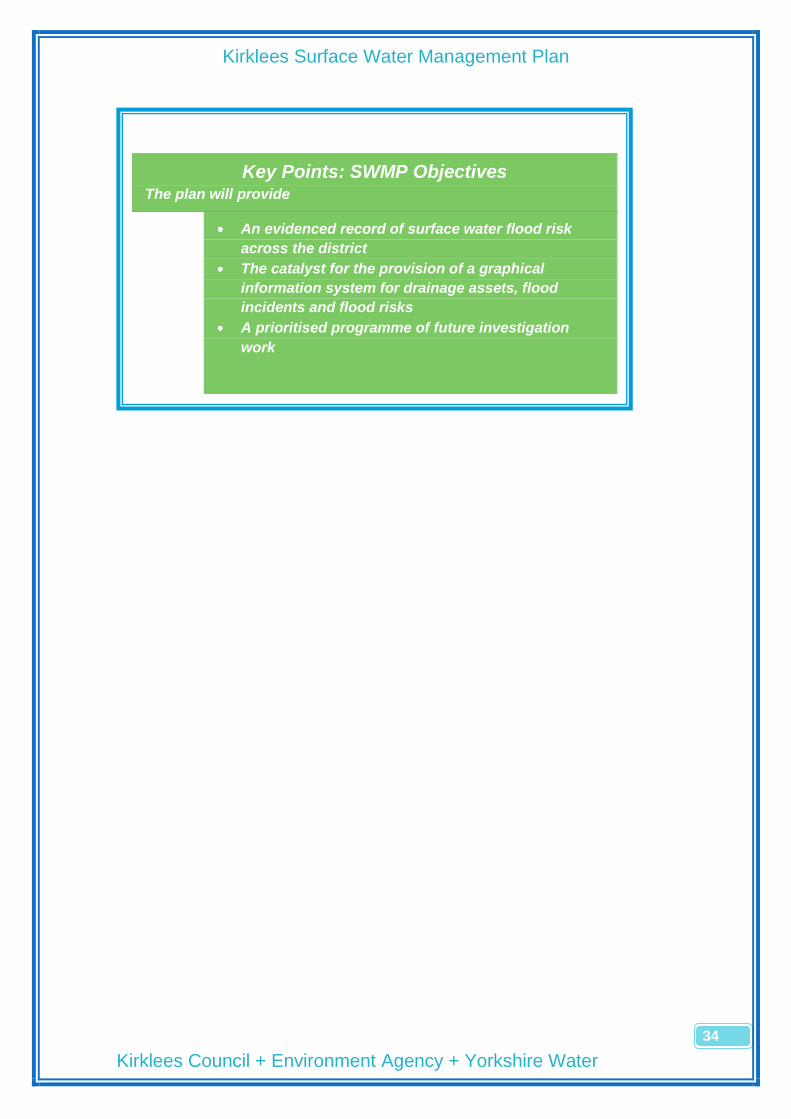
Key Points: SWMP Objectives The plan will provide
An evidenced record of surface water flood risk
across the district
The catalyst for the provision of a graphical
information system for drainage assets, flood
incidents and flood risks
A prioritised programme of future investigation
work
Kirklees Surface Water Management Plan
Kirklees Council + Environment Agency + Yorkshire Water
35
6 Preparation Stage
6.1 Identifying the Need for a SWMP Study
An area-wide SWMP is considered desirable because –
The Level 1 Calder SFRA recommended that SWMPs be produced for a number of
defined areas (The centres of Huddersfield, Mirfield and Dewsbury were
subsequently chosen and surface water modelling has been carried out for these
areas)
Defra‘s recent appraisal of surface water flood risk has highlighted the Kirklees
district as high risk
A Kirklees SWMP offers the opportunity to produce, for the first time, an evidenced
record of existing and future surface water flood risk
The Flood Risk Regulations (2009) require the production of a PFRA by June 2011.
A suitably drafted SWMP will provide much of the evidence required for the PFRA.
6.2 Establishing the Partnership
Work commenced on the SWMP in January 2010 with a broad action to collect ―flood data‖
from as many sources as possible. The diagnostic use of the data was not determined at the
time but a rationale developed as the quantity and quality of the data became apparent.
Formal partnering arrangements were not deemed to be a priority early in the study and
were felt to be more valuable when agreeing the process of data analysis, assessment of
risk and identification of options. Consequently, the first formal partnering meeting was held
on 23 September 2010 with the core group of Kirklees Council (LLFA), Environment Agency
and Yorkshire Water present.
Do we need a SWMP study?
Who are the Council’s partners and
how will the partnership work?
What are the main aims of the SWMP?
How do we engage with
stakeholders?
What information/ evidence do we
use?
How detailed will the assessment be?

Kirklees Surface Water Management Plan
Kirklees Council + Environment Agency + Yorkshire Water
36
The Kirklees SWMP will be a high-level information resource with actions geared towards
further, localised, more-detailed analysis of flood risk. The partnership reflects this by
involving a low number of strategic partners. It is anticipated that stakeholders and other
minor partners will be involved when the more detailed actions are progressed.
The following definitions have been used
Partner – A person or organisation with responsibility for the decision or
actions that need to be taken
Stakeholder – Anyone affected by, or interested in, the problem or solution
The SWMP Partnership is therefore –
o Kirklees Council – Strategic Drainage Team within the Investment and
Regeneration Service, taking lead as LLFA
o Environment Agency
o Water and Sewerage Company (Yorkshire Water)
Minor partners and stakeholders will include –
Partners
o Kirklees Council – Highways
o Kirklees Council – Emergency Planning
o Highways Agency
o Network Rail
Stakeholders
o The general public
o Riparian owners
o Developers
o Local businesses
o Association of British Insurers (ABI)

Kirklees Surface Water Management Plan
Kirklees Council + Environment Agency + Yorkshire Water
37
Roles and Responsibilities within the Partnership
o Roles of Partners – Kirklees, as LLFA, will write, maintain and review the
SWMP, and chair the Partnership meetings. The Environment Agency and
Yorkshire Water will be active partners in ensuring their respective views and
aspirations are included within the SWMP.
o Sharing Information – Systems have been established to facilitate the
sharing of relevant data between partners. The Environment Agency has a
well established system for the sharing of relevant data now formalised
through the website, http://www.geostore.com/environment-agency. A data
sharing protocol is also in place between Kirklees Council and Yorkshire
Water to manage the data flow between the two organisations.
o Engagement with Others – It is not anticipated that other partners and
stakeholders will be consulted on the content of the SWMP. The Plan is
essentially an information tool to allow further investigation of high-risk areas
and it is these investigations which will require close involvement of all
partners and affected stakeholders. Further details are included in Section
6.3.2.
o Partner Resources – Partnership working has been limited to three formal
meetings to minimise the time commitment required from Partners. The
award of the Defra grant to fund the SWMP has allowed Kirklees to allocate
dedicated resources to collect flood incident and drainage asset data to form
the evidence base for the plan. Partners may have to commit further
resources to implement the action plan for the SWMP in investigating high
risk areas in more detail. An indication as to the level of future (Kirklees
Council) resources required to complete detailed investigations are shown in
the Action Plan in Section 9.3.
o Skilled Resources – In recognition of the limited knowledge, experience and
expertise within Kirklees as LLFA, the SWMP is high-level and non-technical.
Implementing all recommendations in the Action Plan may require specific
skills, not currently available within the LLFA.
o Implementation and Monitoring – Kirklees will take responsibility for
implementing actions and monitoring progress on the SWMP. It is possible
that much of the Action Plan and identified longer-term work will be absorbed
within the PFRA and associated Flood Management plans, required under the
Flood Risk Regulations. In addition, local, formal flood management liaison
meetings will be set up to address the Flood and Water Management Act
requirements for agencies to work better with stakeholders, and each other.
SWMP actions will be discussed and monitored at these meetings.
Kirklees Surface Water Management Plan
Kirklees Council + Environment Agency + Yorkshire Water
38
6.3 Scope of the Study
6.3.1 Aims and Objectives
As a general principle, the objectives for the SWMP will be specific, measurable,
achievable, realistic and timebound (SMART)
As a Partnership,
we will map current and potential surface water flood risk areas, irrespective of
source, and engage the community and all stakeholders to share this knowledge
we will determine the consequences of surface water flooding, now and in the future,
so that we can establish our priorities and understand and compare the merits of
different mitigation strategies
we will identify effective, affordable, achievable and, cost-beneficial measures to
mitigate surface water flood risk which achieve multiple benefits, where possible
we will develop the evidence base to inform strategic planning of drainage provision
in large new developments
we will periodically review the plan and monitor the effectiveness of chosen solutions.
6.3.2 Stakeholder Engagement
A limited stakeholder consultation exercise was carried out to assess the value of
initiating a wider process and the results were disappointing. Although knowledge of
both historic flooding incidents and drainage infrastructure is clearly held by residents
and landowners, extracting the information without using significant resources is very
difficult. The scale of the task appears to be challenging for consultees and it is more
appropriate to involve stakeholders in the local issues identified through the risk
assessment process. Consequently, local stakeholder engagement will be a key part
of developing solutions for the higher-risk areas identified in the SWMP.

Kirklees Surface Water Management Plan
Kirklees Council + Environment Agency + Yorkshire Water
39
6.3.3 Sources of Information
Data Type Source Why is it required?
Highway drainage records
Kirklees Highways Dept
To understand mechanisms of highway flooding and provide solutions for flooding problems
Ordinary watercourses
Kirklees Drainage Dept
Capacity and condition data is essential for efficient urban drainage, esp. culverted watercourses
Maintenance regimes and records
All partners Need to target maintenance at areas of greatest flood risk
River models and asset data
Environment Agency
To understand the interaction between river and surface water flooding
Public sewer records Yorkshire Water
To understand interaction between combined/ surface water sewers and watercourses etc
Combined / surface water models
Yorkshire Water
Information on public sewer capacity/ hotspots
Location of critical infrastructure
Kirklees Emergency Planning
To be considered when assessing the overall flood risk
OS mapping data LLFA Sets the base for graphical presentation of risk and historic maps provide evidence of old drainage systems
Surface level data All partners Consideration of flood flow paths and depths
Historic flood incidents
All partners Will influence both current and future risk
Anecdotal evidence Local press, councillors, members of the public
Useful for verifying records and adding to the assets and flood incidents databases
Calder Strategic Flood Risk Assessment
Kirklees Planning Authority
Essential source of background info, but weak on surface water risk
Calder and Don Catchment Flood Management Plans
Environment Agency
Useful background info, but little on surface water risk
6.3.4 The Level of the SWMP Assessment
The SWMP Technical Guidance suggests that a Strategic Level assessment would be
appropriate, which would produce the following outputs
A prioritised list of locations requiring further assessment. This is done through an
assessment of the locations which are considered more vulnerable to surface water
flooding, using available data.
Information gathered as part of the strategic assessment will be used to fulfil the
requirements of Part 2 of the Flood Risk Regulations (2009), where lead local
authorities are required to prepare preliminary assessment maps and reports
Identification of achievable mitigation measures; in particular, immediate or quick win
measures which can be implemented to reduce surface water flooding
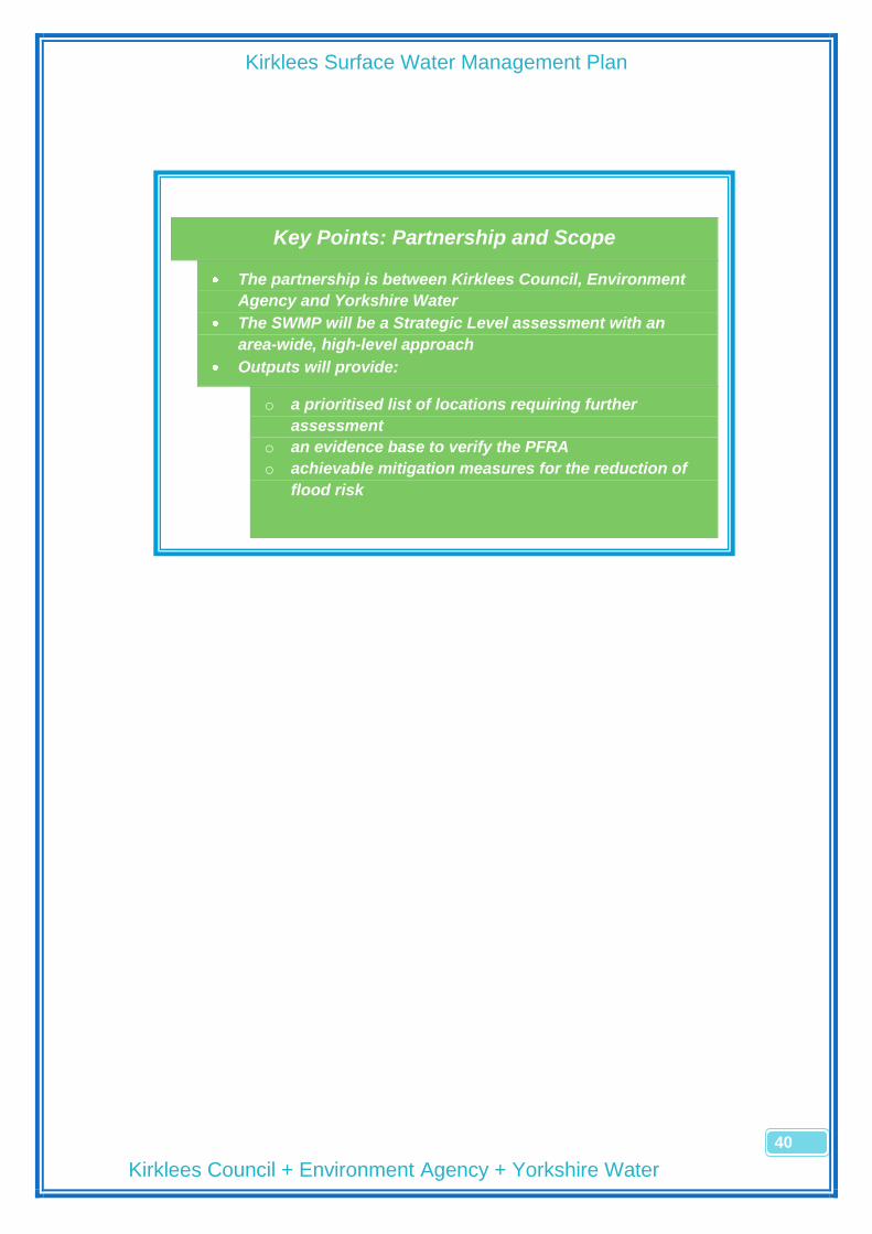
Kirklees Surface Water Management Plan
Kirklees Council + Environment Agency + Yorkshire Water
40
Key Points: Partnership and Scope
The partnership is between Kirklees Council, Environment
Agency and Yorkshire Water
The SWMP will be a Strategic Level assessment with an
area-wide, high-level approach
Outputs will provide:
o a prioritised list of locations requiring further
assessment
o an evidence base to verify the PFRA
o achievable mitigation measures for the reduction of
flood risk

Kirklees Surface Water Management Plan
Kirklees Council + Environment Agency + Yorkshire Water
41
7 Risk Assessment Stage
A Strategic Assessment has been carried out based on known historical flooding, known
drainage infrastructure location and condition and predicted future flooding.
The strategic assessment has identified ‗local‘ hotspots (i.e. parts of a settlement) which are
likely to be at greater risk of surface water flooding and require more detailed assessment.
The approach has been flexible and some elements of an Intermediate Assessment
approach have been included, providing an additional level of detail in places.
7.1 Collating Information
There are five principal sources of data and information which are considered to be
important for the strategic assessment
Historic flood incident data – Data is available from a number of sources
o Kirklees Council – The only records available are those logged on the
Councils Customer Service Request database which date back to 1999.
Significant work has been carried out to manually sift through
drainage/flooding related requests to determine their relevance to FRM.
Approximately 2500 flooding records have been extracted from the database
and are now logged as ―flood incidents‖ on the Councils GIS system
o General Public/ Local Councillors – Whilst it is accepted that there must be
extensive knowledge of flood incidents within local communities, the task of
extracting the information easily and accurately is difficult and beyond the
scope of this study. Limited liaison with ―interested‖ individuals and local
councillors has taken place but little additional information has come from the
process.
How do we collect and organise
the data?
How do we assess the flood
risk?
How do we present the risk?
How do we communicate that
risk to stakeholders and
partners?

Kirklees Surface Water Management Plan
Kirklees Council + Environment Agency + Yorkshire Water
42
o Environment Agency – The Agency has limited information available on
surface water flooding in comparison to the wealth of information on fluvial
flooding but reference has been made in the SWMP to the summer 2007
flooding map and aerial photographs from the 2007 floods.
o Yorkshire Water – The DG5 database, recording flood incidents associated
with the public sewer system, will be used in the detailed risk assessment of
areas highlighted in the SWMP as being at higher risk of surface water
flooding
Environment Agency surface water flood maps – These maps provide an
indication of areas which are more susceptible to flood first, flood deepest and flood
more frequently.
Ground model data – The GIS-based method of recording and presenting the
information gives access to Ordnance Survey data, such as historic maps and
contours as well as other Council datasets such as environmental, land
contamination and land ownership information.
SFRA/ CFMP – These sources of evidence provide further information on historical
flood incidents and information on other sources of flooding which have been taken
into account in the SWMP. Previous policy recommendations in relation to FRM
have also been considered within the SWMP.
Drainage Asset Records – A considerable amount of work has been carried out, as
part of this SWMP, to determine the location and capacity of the surface water
drainage system across the district. Much of the culverted watercourse and highway
drainage network is unrecorded but its location, condition and capacity is critical to
any meaningful understanding of flooding mechanisms and potential solutions. A
better understanding of the interaction of main rivers, ordinary watercourses, highway
drains and public sewers is required and will facilitate reductions in surface water
flood risk across the district.
A note on the collection of asset data – A structured investigation of drainage assets
was considered to be an important stage in developing achievable options for reducing flood risk.
Historical records of culverted watercourses and highway drains, held by a succession
of authorities responsible for land drainage, are sparse. Where these are available, they have
formed the basis for the current asset record.
Every significant populated area in the district has been examined for possible drainage
assets, by reference to old ordnance survey plans for evidence of old infrastructure eg troughs,
wells, mill culverts, streams etc. Asset information from recent flood incident investigations has
been transferred into the GIS system and a systematic new process for transferring knowledge
held by council drainage officers onto the system has also been carried out. A limited number of
site surveys at prioritised locations have been undertaken to try and ―fill in the gaps‖ in the

Kirklees Surface Water Management Plan
Kirklees Council + Environment Agency + Yorkshire Water
43
7.2 Undertaking the Strategic Assessment
The Guidance encourages a flexible approach to the use and interpretation of the data and
resources available to the LLFA in carrying out the assessment of surface water flood risk.
7.2.1 Method of Assessment
The following rationale has been used to record, assess and quantify surface water flood risk
in this SWMP –
The Councils corporate GIS system, ―Planweb‖, has been used to record and display
the data collected for, and relevant to, the SWMP.
Planweb,
o is Mapinfo based and offers compatibility with the Councils chosen method
for asset recording and flood incident logging
o offers compatibility with data available from partners
o allows access via ―layers‖ to other Council and national datasets eg EA flood
maps, current planning applications, environmental data etc
o is familiar to staff, intuitive and corporately maintained
The quality and quantity of data is improving with time and this initial Strategic - level
SWMP is based on incomplete data. The analysis carried out will be ―of the moment‖
information.
The value of recording the drainage asset will become apparent as detailed
investigations of areas provisionally identified as high flood risk, are investigated in more detail
and options for mitigating flood risk are developed.
The drainage asset is incomplete, resources are not available to proactively survey and
record assets, and it is unlikely that we will ever be able to record the whole asset. However,
accurate analysis of surface water risk, and the development of solutions, will only be possible if
we work towards a comprehensive record of the various systems.
Recognition of the current incompleteness of the drainage asset record is useful in
understanding the potential inaccuracies in determining causes and solutions. A summary of the
recorded drainage asset is shown below, together with an estimate of the length of unrecorded
asset.
Drainage Asset Recorded Length (km)
Estimated Total Length
(km)
% Unrecorded
Highway Drain 50 600 92
Culverted Watercourse 40 400 90
Open Ordinary watercourse (Significant)
- 600 -
YW Public Sewers 5000 5000 0

Kirklees Surface Water Management Plan
Kirklees Council + Environment Agency + Yorkshire Water
44
providing a base document on which further refinements can be made as more
supporting data becomes available
The only quantitative assessment of analytical risk made, is that associated with the
indicative 1 in 200 year flood outlines on the Surface Water Flood Maps supplied by
the EA.
The majority of the assessment of flood risk is made subjectively using a
combination of weighted, scored parameters from other data. The risk assessment
methodology is detailed in Appendix 1.
The method developed to quantify relative flood risk is similar to the method for the
risk assessments carried out to produce the ―default‖ maps for Preliminary Flood Risk
Assessments. However, it has been developed independently, reflecting a local
judgement on the weighting and relevance of data. The intention is to produce a body
of evidence in a format that will allow easy verification of the nationally developed
default maps with an independent approach.
7.2.2 Results of Assessment
The area of the study has been divided into approximately 1600, 500x500m
squares and each square has been ―scored‖ in accordance with the matrix in
Appendix 1. The results are summarised in the table in Appendix 1.
All squares have been coloured, reflecting their total risk score, with highest flood
risk areas heavily shaded and lowest risk lightly shaded. A larger scale version of
the map is included in Appendix 2.

Kirklees Surface Water Management Plan
Kirklees Council + Environment Agency + Yorkshire Water
45
Appendix 2 also shows further maps indicating the 50, 150 and 300 highest flood
risk areas across the district
7.3 Mapping and Communicating the Risk
7.3.1 Mapping
The processes around determining flood risk are complex, abstract and imprecise. They are
generally subjective assessments of risk based on a limited amount of fact and a large
amount of circumstantial evidence. The challenge is to present the overall assessment of
flood risk in a manner that is clear and accessible to all and allows access to the supporting
data when required.
Digital mapping of the data and the results of the assessment process, provides a readily
understandable media that is consistent with other Council and Partner formats.
Digital mapping will allow subsequent reanalysis of the data as and when new information is
available, providing a tool which can be regularly updated and refined.
Digital mapping will help to determine
the number of people living in the area who are likely to be affected in the event of
flooding
the type of economic activity likely to be affected in the event of flooding
industrial activities in the area that may increase the risk of pollution in the event of
flooding
relevant protected areas that may be affected in the event of flooding
7.3.2 Communicating
The main purpose of flood mapping is to provide an evidence base for partners and
stakeholders to understand flood risk. This will include:
helping to engage stakeholders in understanding surface water flood risk
informing the spatial planning process by improving the evidence base in the Local
Development Framework and directing the Development Control Process towards
sustainable surface water solutions for sites of high flood risk
informing emergency planning functions carried out by Local Resilience Forums
identifying whether critical infrastructure is at risk from surface water flooding and
where appropriate, communicating this risk to the responsible stakeholders
Kirklees Surface Water Management Plan
Kirklees Council + Environment Agency + Yorkshire Water
46
General Stakeholders
The general public should be engaged in the development and implementation of the
SWMP, in accordance with the engagement plan specified in the preparation stage of the
SWMP study (Section 6.3.2). Under the Flood Risk Regulations (2009) there is a
requirement to publish the preliminary assessment reports and maps (Part 2), and the flood
risk and flood hazard maps (Part 3) in areas of significant risk.
Therefore, flood maps produced as part of the SWMP study will be shared with, and
communicated to, the public. The presentation of information is discussed further in Section
9.4.
Planning Authority
Kirklees Planning Department will be encouraged to use the map outputs from the SWMP to
augment the Calder SFRA, where surface water flooding has not been addressed in detail.
Planning policies and site allocations may be influenced by the SWMP, if the SWMP study
highlights significant risks which were previously not taken into account.
Outputs from the SWMP study will be used in the Sustainability Appraisal of the Core
Strategy to provide evidence, sustainability objectives and indicators.
The SWMP will provide Planning Development Control with the first available evidence base
for surface water flood risk, to complement existing information on fluvial (river) flood risk. It
is anticipated that new developments in identified high surface water flood risk areas will be
rigorously assessed for suitability.
The high flood risk allocated to certain locations will help to highlight the measures that may
need to be taken in the planning process to manage the incremental increase of flood risk as
a result of urban creep.
Emergency Planning
Surface water flooding has very short lead times and is hard to predict in real time because
local topography and drainage infrastructure affects the direction or runoff and location of
flooding. However, the initial assessment carried out as part of this SWMP will provide the
basis for future identification of the likely flow pathways and locations of ponding of surface
water in those areas of highest flood risk.
The results of this future analysis will be fed to the Councils Emergency Planning team to
improve the Councils response to surface water flooding events.
Critical Infrastructure
Where the flood risk assessment process highlights critical infrastructure that may be
vulnerable to flooding, the evidence will be presented to the responsible authority or owner
with a recommendation to consider further investigations to determine the necessity for
mitigation measures.

Kirklees Surface Water Management Plan
Kirklees Council + Environment Agency + Yorkshire Water
47
Key Points: The Assessment of Risk
Historic flood incidents from the last 10 years are now
mapped on GIS
Systems are set up to auto-record future flood incidents on
GIS
Local area flood risk is determined from a combination of
recorded incidents/ EA flood maps/ land sensitivity
A record of relative flood risk from surface water has been
produced, highlighting high priority locations
Communication of flood risk to partners and stakeholders is
key to the success of the SWMP

Kirklees Surface Water Management Plan
Kirklees Council + Environment Agency + Yorkshire Water
48
Leave page blank for back to back printing

Kirklees Surface Water Management Plan
Kirklees Council + Environment Agency + Yorkshire Water
49
8 Options Stage
8.1 Identifying Measures
A range of measures are available to manage surface water flood risk. Consideration of the
measures to be used will not, at this stage, be constrained by cost or viability but will seek to
maximise the opportunity to resolve any other related flooding issues at the same time,
delivering multiple benefits. These additional benefits include water quality, biodiversity and
public amenity.
The Source-Pathway-Receptor model used in many FRM policies and technical notes can
be used to categorise the measures available:
Source (Controlling the surface water at its place of origin)
Measures – Green Roof
Soakaways
Swales
Permeable Paving
Rainwater Harvesting
Detention Basins
Ponds and Wetlands
Pathways (The routes that both overland and underground flows of water follow)
Measures - Increasing capacity in drainage systems
Separation of foul and surface water sewers
Improved maintenance regimes
What measures can we
take to reduce local flood
risk?
Agree a hierarchy of
achievable measures.
Which areas do we assess
first?
How do we carry out the
assessment?

Kirklees Surface Water Management Plan
Kirklees Council + Environment Agency + Yorkshire Water
50
Managing/ redirecting overland flows
Land management practices
Receptors (The people, property and environment affected by flooding)
Improved weather warnings
Using planning policies to influence development
Using temporary or demountable flood barriers
Social change, education and awareness, encouraging self-help
Improved resilience and resistance measures
8.2 Priorities for Assessment
The risk assessment process carried out on a local, square by square basis, has highlighted
those areas where flood risk is highest and where further investigation is required to
determine the flood mechanism and options for reducing the risk. The scoring process will
establish a programme of further investigation work spread across the whole district. (See
Section 9)
8.3 Method of Assessment
Detailed assessments of priority flood risk areas need to be methodical, consistent, robust
and as simple as is practicable. A standard approach will be taken to assess each high
priority area and a draft template has been developed to provide a structured assessment
report that could form the basis for future dialogue with partners and stakeholders.
The report template includes the following:
A description of the topography and demography of the area
A record of previous flood incidents (Map)
An assessment of future surface water flood risk indicating depth severity and extent
(Map)
A schedule of affected properties and land, including number of people and
assessment of potential damage and/or disruption
A statement on the presence and condition of drainage systems in the area, including
watercourses, public sewers, private systems and bodies of water
Land-use planning proposals in the area
An assessment of the vulnerability of properties and infrastructure in the area to
flooding, sensitivity (use) of the building/land, threshold (floor) levels, resilience and
recovery standard, escape routes.
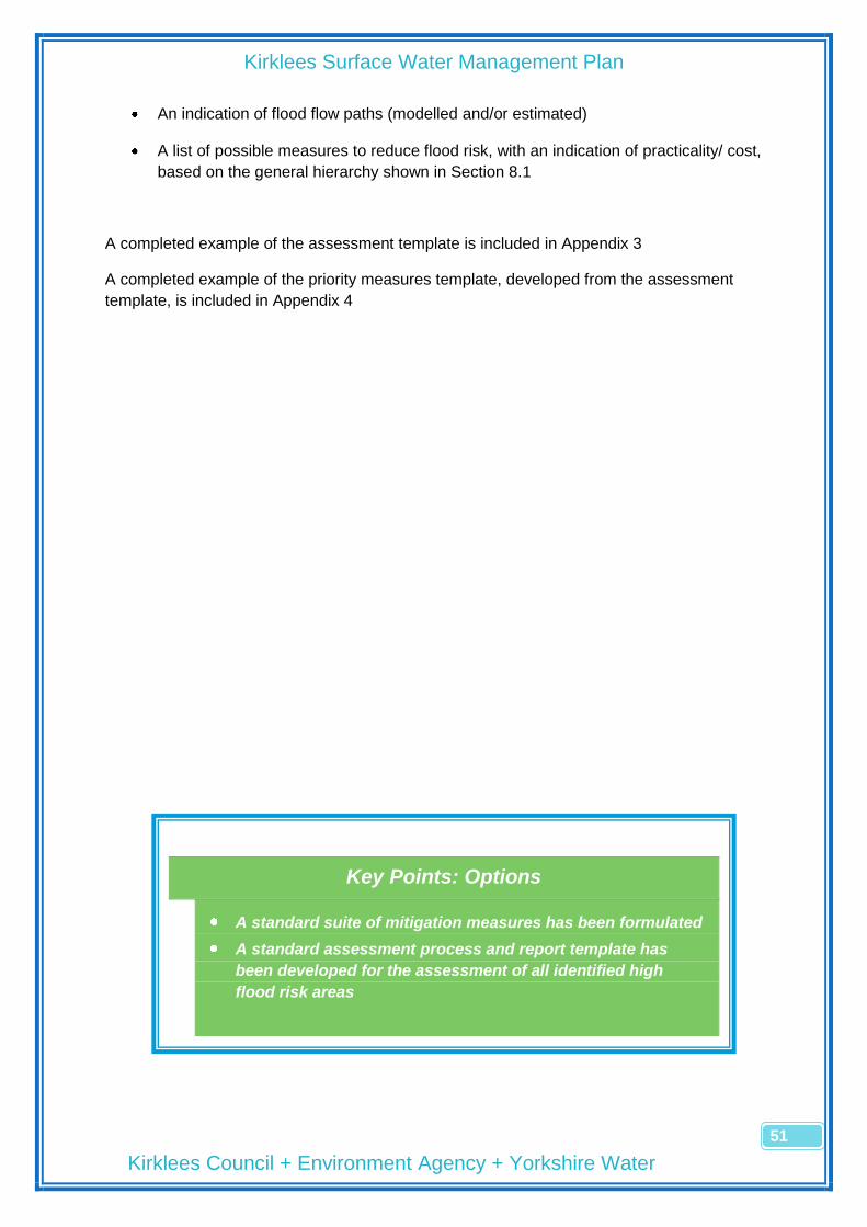
Kirklees Surface Water Management Plan
Kirklees Council + Environment Agency + Yorkshire Water
51
An indication of flood flow paths (modelled and/or estimated)
A list of possible measures to reduce flood risk, with an indication of practicality/ cost,
based on the general hierarchy shown in Section 8.1
A completed example of the assessment template is included in Appendix 3
A completed example of the priority measures template, developed from the assessment
template, is included in Appendix 4
Key Points: Options
A standard suite of mitigation measures has been formulated
A standard assessment process and report template has
been developed for the assessment of all identified high
flood risk areas

Kirklees Surface Water Management Plan
Kirklees Council + Environment Agency + Yorkshire Water
52
Leave page blank for back to back printing

Kirklees Surface Water Management Plan
Kirklees Council + Environment Agency + Yorkshire Water
53
9 Implementation and Review
9.1 The Extent and Severity of Surface Water Flood Risk
The risk assessment process in Section 7 has been used to assess the level of flood risk
across the district and the results are detailed in Appendix 1. The following table summarises
the results:
Level of Flood Risk Number of Areas (500m x 500m squares)
Severe 72
High 143
Medium 157
Low 232
Not Significant 1032
Total 1636
It is possible to refine the above analysis to prioritise individual areas within each risk
category, which will produce a programme of future investigation and detailed risk
assessment work leading to a suite of mitigation measures for each identified area. A
programme for further work, based on the highest priority squares, has been produced and
is listed in Section 9.2.
The strategic approach to local surface water flood management is in a process of
development and the recent European legislation, The Flood Risk Regulations 2009, impose
a duty on Lead Local Flood Authorities to follow a structured approach to understanding,
publicising and reducing surface water flood risk in their districts. There are clear parallels
between the Preliminary Flood Risk Assessment (PFRA), required by the Regulations, and
the SWMP process, followed by Kirklees. It is appropriate, where areas identified in the
SWMP as severe/high risk are recorded as key local Flood Risk Areas through the PFRA
process, that they are further assessed through the Councils obligations under the
Regulations. Other areas of local surface water flooding detailed in this SWMP but not
Develop a programme of further
detailed investigations
Develop a broad Action Plan
How do we present the findings/
next steps to the Public?
How and when do we review the
plan?

Kirklees Surface Water Management Plan
Kirklees Council + Environment Agency + Yorkshire Water
54
identified in the PFRA, will be investigated by the Council separately, when resources and
other priorities permit.
The Council‘s current legal obligations lie mainly with the Flood Risk Regulations and these
will direct our immediate work. The Action Plan for the SWMP will be a programme of further
investigations of those areas identified as at high risk from surface water flooding. It is likely
that many of these areas will be included within the wider high risk areas that will be
identified through the assessment process required by the Flood Risk Regulations.
9.2 Immediate Priorities
The 50 highest priority areas (Squares) for surface water flood risk, forming the initial
programme of further investigation and detailed assessment, are as follows:
Priority Ordnance Survey Reference Centre of Square Area
1 SE1408SW Holmfirth Bus Station Holmfirth
1 SE2220SW Huddersfield Rd gyratory Ravensthorpe
3 SE1516SW Lidl, Wakefield Road Aspley
4 SE1316SW The Triangle Paddock
4 SE1416NW Westgate Huddersfield TC
4 SE1417NE Hillhouse Lane Fartown
4 SE2023NE The Swan PH, Leeds Road Liversedge
8 SE0814SW Colne Valley Leisure Centre Slaithwaite
8 SE1517NW Town Estate, Leeds Road Huddersfield
8 SE2421NE Town Hall Dewsbury
8 SE2423NE Rouse Mill Lane Batley
12 SE0411NE Station Road Marsden
12 SE1417SW John William Street Huddersfield TC
12 SE1417SE Gt Northern Street gyratory Huddersfield TC
15 SE1716NW Green Lea Mills Dalton
16 SE1618SW Syngenta Works, Leeds Road Huddersfield
17 SE1717SW Kirkwood Hospice Dalton
17 SE1825SE Westgate Cleckheaton
19 SE1315SE Lockwood Road Lockwood
19 SE1311NE Honley Ambulance Station Honley
19 SE1415NW Queens Mill Lane Lockwood
19 SE1418NE Dewhurst Road Fartown Green
19 SE1518SW Textile centre, Leeds Road Huddersfield
19 SE1925NW Victoria Mills, Bradford Road Cleckheaton
25 SE0910NE Station Street Meltham
25 SE1118NE Briar Court hotel, Halifax Road Birchencliffe
25 SE1116SE Armitage Road Milnsbridge
25 SE1115NE Market Street Milnsbridge
25 SE1417NW St Johns Road Huddersfield
25 SE1418SW Norman Park Birkby
25 SE1618NE Ashgrove Road Deighton
25 SE2024SW Knowler Hill Liversedge
25 SE2220NW Broomer Street Ravensthorpe
25 SE2225NE Bradford Road Birstall
25 SE2422NW Mill Road Batley
36 SE0713NE Manchester Road Slaithwaite
36 SE2422SW Dewsbury College Dewsbury
38 SE2419NW Brewery Lane Thornhill Lees
38 SE2423SE Bradford Road Batley
40 SE1720SW Station Road Bradley

Kirklees Surface Water Management Plan
Kirklees Council + Environment Agency + Yorkshire Water
55
41 SE0814SE Grosvenor Chemicals Linthwaite
41 SE2024SE Listing Lane Liversedge
41 SE1116SW Royd Street Milnsbridge
41 SE1416SE Queen Street Sth Huddersfield
41 SE1518SE Arch Chemicals, Leeds Road Huddersfield
41 SE1616NW Grosvenor Road Dalton
41 SE1618NW Playing Fields, Leeds Road Huddersfield
41 SE2220SE Huddersfield Road Ravensthorpe
41 SE2324NW Carlinghow Lane Batley
41 SE2424SE The Mill, Bradford Road Batley
Table 9.2
9.2.1 Verification of the Prioritisation Process
The significant flooding from the summer 2007 rainfall event presents us with an opportunity
to verify, to some extent, the validity of the risk assessment process used in the SWMP. The
Environment Agency‘s report, following the flooding, suggested that 70% of local flooding
across the Yorkshire region was caused by surface water (pluvial), rather than river (fluvial)
mechanisms.
The Council has limited information available on the areas that suffered flooding and they
are summarised in table 9.2.1 below, together with their SWMP priority ranking from the
table in 9.2.
Summer 2007 Flooding Locations
Cause? Ordnance Survey Reference
SWMP Ranking
Broomer Street, Ravensthorpe SW SE2220NW Severe (25th)
St Peg Lane, Cleckheaton ? SE1925SW High (>50th)
Radulf Gardens, Liversedge River SE2024SW Severe (25th)
Gawthorpe Lane, Kirkheaton SW SE1916NW Low (>50th)
Huddersfield Road, New Mill SW SE1608NW High (>50th)
Riverside, Clayton West River/SW SE2511SW High (>50th)
Water Street, Fleet St, Dearne St, Dearne Terrace, Barnsley Rd, Scissett
River SE2410SE High (>50th)
Ings Crescent, Liversedge River SE2023NE Severe (4th)
Broadoaks Close, Chickenley River SE2621SW Medium (>50th)
Barnsley Road, Flockton SW SE2314NW Low (>50th)
Steannard Lane, Mirfield SW SE2019SE Medium (>50th)
Low Town, Kirkburton ? SE1912NE High (>50th)
Parkgate, Skelmanthorpe River SE2311SW Low (>50th)
Leeds Road Playing Fields, Huddersfield
SW SE1618NW Severe (41st)
Langley Lane, Scissett River SE2511SW High (>50th)
Gynn Lane, Honley SW SE1411NW High (>50th)
Summerfield Grove, Lepton SW (Soakaway) SE1814NE Low (>50th)
Kenyon Bank, Denby Dale SW (Blocked Grille)
SE2208SE High (>50th)
Abbey Road, Shepley SW SE1910SE Medium (>50th)
Moor Lane, Gomersal SW SE2126NW High (>50th)

Kirklees Surface Water Management Plan
Kirklees Council + Environment Agency + Yorkshire Water
56
Huddersfield Road, Liversedge SW SE2023NE Severe (4th)
Balme Road, Cleckheaton SW SE1825NE Low (>50th)
Westgate, Cleckheaton SW SE1825SE Severe (17th)
Thorntonville, Cleckheaton SW SE1924NE High (>50th)
Manor Road, Clayton West SW SE2611NW Medium (>50th)
Valley Road, Liversedge SW SE2024SW Severe (25th)
Church Green, Kirkburton SW (Blocked Grille)
SE1912NE High (>50th)
Table 9.2.1
The correlation between the actual 2007 flooding locations and the predicted locations from
the SWMP risk assessment process is good, with the majority of flooding locations identified
as high or severe flood risk in the SWMP.
9.3 The SWMP Action Plan
Further, detailed analysis of the areas identified as high flood risk will form the core of the
Action Plan. A further tranche of work, developing the most effective ways of applying the
evidence in the SWMP to improve our FRM processes will form the rest of the Plan.
Reference Action Proposed Outcomes Timescale
SWMP1 Prepare and implement a programme of further detailed investigations for the 50 highest risk areas identified in Section 9.2, producing Flood Risk Assessment Reports and Priority Measures Summary for each area
An initial summary of the flood risk issues in the defined area
A suite of measures that can be implemented to reduce flood risk
Further evidence to support the agreement of PFRA Flood Risk areas
Programme with timescales to be produced by Jan 2011.
SWMP2 Develop an operational relationship with SWMP partners to investigate and explore causes of and solutions for flooding in the priority areas
Data sharing
Skill/ knowledge sharing
Matching improvement and maintenance priorities with identified flood risk
Trial the first Flood Risk Assessment Report in February 2011
SWMP3 Produce a communications strategy for the dissemination of information from the completed Flood Risk Assessment reports for each priority area
Evidence and suggested mitigation measures to be discussed with landowners, partners and other responsible agencies
Strategy to be completed by March 2011
SWMP4 Integrate the evidence from the SWMP into the Planning Development Control assessment process
Improving the quantity, quality and relevance of FRM advice through the planning consultation process
Information to be imported to Council‘s GIS system by March 2011
SWMP 5 Use the SWMP as the local evidence base to challenge or confirm the default Flood Risk Areas issued by the EA for the PFRA
Agreement of PFRA Flood Risk Areas by June 2010
Completed and presented to Scrutiny for approval by April 2011

Kirklees Surface Water Management Plan
Kirklees Council + Environment Agency + Yorkshire Water
57
9.4 Presentation and Publication of Results
The Kirklees SWMP will be made available to the general public and promoted by the
Council as an evidence base to carry out further work into prioritised areas of high surface
water flood risk. The information in the report is sensitive and care needs to be taken to
ensure that it is not taken out of context, is as clear and unambiguous as it can be, is
discussed with individuals when requested and, ultimately, leads to a properly evidenced
assessment of surface water flood risk in each identified area.
The SWMP will be published on the Council‘s website and awareness will be raised with
local councillors, local media and the minor partners identified in Section 6.2 of the SWMP.
9.5 Reviewing the Action Plan
Although much of the future assessment work will be carried out as part of the Councils legal
responsibilities under the Flood Risk Regulations 2009, it is appropriate that an annual audit
be carried out on progress against the action plan identified in Section 9.3.

Kirklees Surface Water Management Plan
Kirklees Council + Environment Agency + Yorkshire Water
58
Key Points: Implementation and Review
The spread of surface water flood risk across Kirklees has
been determined
An Action Plan highlighting the priority areas for further
investigation and proposed uses for the FRM evidence has
been produced
A commitment to publicise and regularly review the plan

Kirklees Surface Water Management Plan
Kirklees Council + Environment Agency + Yorkshire Water
59
Appendix 1
Risk Assessment Scoring Methodology
Recorded flood incident – those incidents recorded by Kirklees Council as flood
incidents
SW map areas – A general indication of flood risk using the EA surface water maps
Recorded drainage assets – a measure of the density/completeness of the drainage
infrastructure
Land use – reflecting the density of residential/industrial/retail units
Critical infrastructure – reflecting the density and criticality of sensitive buildings/
transport links
Surface Water Flooding Risk Scoring Matrix
Risk Factor
Factor Weighting
(a)
Description of Factor (Risk Score) (b)
Score (a) x (b)
Like
liho
od
Recorded flood incident
0 1 to 5 6 to 10 10+
4 1 3 4 5
Surface water map areas
None Low Medium High
6 0 2 4 5
Recorded drainage assets
None Limited Full
2 1 2 3
Total Likelihood Score (X)
Co
nse
qu
en
ces Land use
Open Rural Urban Fringe
Central Urban
3 1 3 4 5
Critical infrastructure
None Low
density High
density
5 0 2 4
Total Consequences Score (Y)
Overall Risk Score (X) x (Y)
Overall Risk Score (XxY)
<100 101 to
300 301 to
500 501 to
900 >900
Overall Risk Rating
Not Significant
Low Medium High Severe

Kirklees Surface Water Management Plan
Kirklees Council + Environment Agency + Yorkshire Water
60
Risk Assessment Scores
Rank General Area Ordnance Survey Ref
Total Flood Risk Score
Rank General Area
Ordnance Survey Ref
Total Flood Risk Score
1 Holmfirth SE1408SW 1550
46 Huddersfield SE1618NW 920
2 Ravensthorpe SE2220SW 1550
47 Liversedge SE2024SE 920
3 Huddersfield SE1516SW 1488
48 Ravensthorpe SE2220SE 920
4 Marsh SE1316SW 1426
49 Batley SE2324NE 920
5 Huddersfield SE1416NW 1426
50 Batley SE2424SE 920
6 Huddersfield SE1417NE 1426
51 Bradley SE1720SW 896
7 Liversedge SE2023NE 1426
52 Marsden SE0411SE 880
8 Slaithwaite SE0814SW 1364
53 Marsden SE0511NW 880
9 Huddersfield SE1517NW 1364
54 Slaithwaite SE0814NW 880
10 Liversedge SE2023NE 1364
55 Linthwaite SE0914SE 880
11 Dewsbury SE2421NE 1364
56 Holme SE1010SW 880
12 Batley SE2423NE 1364
57 Holme SE1010NW 880
13 Marsden SE0411NE 1344
58 Holmbridge SE1206NW 880
14 Huddersfield SE1417SW 1240
59 Netherton SE1307NW 880
15 Huddersfield SE1417SE 1240
60 Armitage Bridge SE1313NW 880
16 Dalton SE1716NW 1240
61 Honley SE1411NW 880
17 Huddersfield SE1618SW 1178
62 New Mill SE1608NW 880
18 Dalton SE1717SW 1120
63 Oakenshaw SE1727NW 880
19 Cleckheaton SE1825SE 1120
64 Ravensthorpe SE2120SE 880
20 Lockwood SE1315SE 1058
65 Ravensthorpe SE2319NW 880
21 Honley SE1311NE 1058
66 Lockwood SE1315SW 874
22 Huddersfield SE1415NW 1058
67 Hudds SE1316SE 874
23 Fartown SE1418NE 1058
68 Huddersfield SE1518NW 874
24 Huddersfield SE1518SW 1058
69 Batley SE2324NW 868
25 Mirfield SE1925NW 1058
70 Linthwaite SE0914SW 840
26 Meltham SE0910NE 1012
71 Kirkburton SE1912NE 840
27 Lindley SE1118NE 1012
72 Birstall SE2225NW 840
28 Crosland SE1116SE 1012
73 Dalton SE1618SE 828
29 Crosland SE1115NE 1012
74 Linthwaite SE0914NE 800
30 Fartown SE1417NW 1012
75 Meltham SE1011SE 800
31 Fartown SE1418SW 1012
76 Meltham SE1010NE 800
32 Deighton SE1618NE 1012
77 Honley SE1313NE 800
33 Liversedge SE2024SW 1012
78 Honley SE1412SW 800
34 Batley SE2225NE 1012
79 Brockholes SE1411NE 800
35 Batley SE2422NW 1012
80 Brockholes SE1411SE 800
36 Ravensthorpe SE2220NW 1000
81 Newsome SE1510NW 800
37 Slaithwaite SE0713NE 966
82 Almondbury SE1714NW 800
38 Dewsbury SE2422SW 966
83 Denby Dale SE2208SE 800
39 Thornhill Lees SE2419NW 966
84 Mirfield SE2019NE 800
40 Batley SE2423SE 966
85 Liversedge SE1924NE 800
41 Slaithwaite SE0814SE 920
86 Heckmondwike SE2122NE 800
42 Milnsbridge SE1116SW 920
87 Birstall SE2126SE 800
43 Huddersfield SE1416SE 920
88 Ravensthorpe SE2219NW 800
44 Huddersfield SE1518SE 920
89 Batley SE2425SE 800
45 Huddersfield SE1616NW 920
90 Dewsbury SE2322NW 784
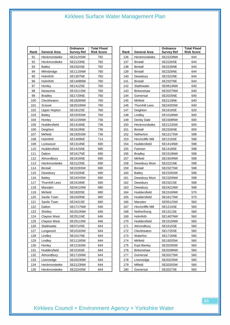
Kirklees Surface Water Management Plan
Kirklees Council + Environment Agency + Yorkshire Water
61
Rank General Area Ordnance Survey Ref
Total Flood Risk Score
Rank General Area
Ordnance Survey Ref
Total Flood Risk Score
91 Heckmondwike SE2124SW 782
136 Heckmondwike SE2223NW 644
92 Heckmondiwke SE2123NE 782
137 Birstall SE2226SE 644
93 Batley SE2324SE 782
138 Birstall SE2226NE 644
94 Milnsbridge SE1115NW 760
139 Birstall SE2326NE 644
95 Holmfirth SE1307NE 760
140 Dewsbury SE2322NE 644
96 Holmfirth SE1408NW 760
141 Birstall SE2327NE 644
97 Honley SE1412SE 760
142 Slaithwaite SE0813NW 640
98 Newsome SE1511SW 760
143 Birkenshaw SE2027NW 640
99 Bradley SE1720NE 760
144 Gomersal SE2025NE 640
100 Cleckheaton SE1826NW 760
145 Mirfield SE2119NE 640
101 Scisset SE2510NW 760
146 Thornhill Lees SE2420SW 640
102 Upper Hopton SE1912SE 760
147 Deighton SE1619SE 620
103 Batley SE2325SW 760
148 Lindley SE1018NW 600
104 Honley SE1215NW 736
149 Denby Dale SE2308NW 600
105 Huddersfield SE1416NE 736
150 Heckmondwike SE2123SW 600
106 Deighton SE1619NE 736
151 Birstall SE2326NE 600
107 Mirfield SE1925SW 736
152 Netherton SE1217SW 598
108 Holmfirth SE1409NE 714
153 Hinchcliffe Mill SE1216SE 598
109 Lockwood SE1314NE 690
154 Huddersfield SE1414NW 598
110 Huddersfield SE1415NE 690
155 Fartown SE1418SE 598
111 Dalton SE1617NE 690
156 Bradley SE1519NW 598
112 Almondbury SE1616NE 690
157 Mirfield SE1924NW 598
113 Heckmondwike SE2123SE 690
158 Dewsbury Moor SE2221NE 598
114 Birstall SE2226SW 690
159 Birstall SE2327SW 598
115 Dewsbury SE2320NE 690
160 Batley SE2326SW 598
116 Batley SE2424SW 690
161 Dewsbury Moor SE2320NW 598
117 Thornhill Lees SE2419NE 690
162 Dewsbury SE2321SE 598
118 Marsden SE0411NW 680
163 Dewsbury SE2421NW 598
119 Mirfield SE1820SE 680
164 Huddersfield SE1516NW 570
120 Savile Town SE2420NE 660
165 Huddersfield SE1617SW 570
121 Savile Town SE2421SE 660
166 Marsden SE0512SW 560
122 Dalton SE1717NW 646
167 Hinchcliffe Mill SE1214SE 560
123 Shelley SE2010NW 646
168 Netherthong SE1311SE 560
124 Clayton West SE2511NE 646
169 Holmfirth SE1407NW 560
125 Clayton West SE2511SW 646
170 Huddersfield SE1515NW 560
126 Slaithwaite SE0714SE 644
171 Almondbury SE1515SE 560
127 Longwood SE1016SW 644
172 Cleckheaton SE1725SE 560
128 Lindley SE1017NE 644
173 Waterloo SE1716NE 560
129 Lindley SE1119SW 644
174 Mirfield SE1920SW 560
130 Honley SE1216SW 644
175 East Bierley SE2029SW 560
131 Huddersfield SE1516SE 644
176 Birkenshaw SE2028NW 560
132 Almondbury SE1715NW 644
177 Gomersal SE2027SW 560
133 Liversedge SE2023NW 644
178 Liversedge SE2023SW 560
134 Heckmondwike SE2123NW 644
179 Mifield SE2020SW 560
135 Heckmondwike SE2224SW 644
180 Gomersal SE2027SE 560
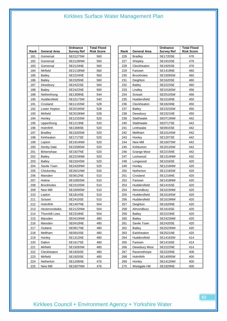
Kirklees Surface Water Management Plan
Kirklees Council + Environment Agency + Yorkshire Water
62
Rank General Area Ordnance Survey Ref
Total Flood Risk Score
Rank General Area
Ordnance Survey Ref
Total Flood Risk Score
181 Gomersal SE2127SW 560
226 Bradley SE1720SE 476
182 Gomersal SE2126NW 560
227 Shepley SE1910SE 476
183 Gomersal SE2124NE 560
228 Cleckheaton SE1925SE 476
184 Mirfield SE2119NW 560
229 Fartown SE1419NE 460
185 Batley SE2224NE 560
230 Brockholes SE1509SW 460
186 Batley SE2325NE 560
231 Deighton SE1620SE 460
187 Dewsbury SE2422SE 560
232 Batley SE2223SE 460
188 Batley SE2422NE 560
233 Lindley SE1018SW 456
189 Netherthong SE1309NE 544
234 Scisset SE2510SW 456
190 Huddersfield SE1517SW 540
235 Huddersfield SE1516NE 450
191 Crosland SE1115SW 528
236 Cleckheaton SE1824NE 450
192 Lower Hopton SE2019SW 528
237 Batley SE2323SW 450
193 Mirfield SE2019NW 528
238 Dewsbury SE2321NE 450
194 Honley SE1215SW 520
239 Slaithwaite SE0713NW 442
195 Upperthong SE1213NE 520
240 Slaithwaite SE0717SE 442
196 Holmfirth SE1308SE 520
241 Linthwaite SE0915SE 442
197 Bradley SE1520SW 520
242 Meltham SE1014SW 442
198 Kirkheaton SE1717SE 520
243 Honley SE1207SE 442
199 Lepton SE1914NW 520
244 New Mill SE1607SW 442
200 Denby Dale SE2208SW 520
245 Kirkburton SE2013SW 442
201 Birkenshaw SE1927NE 520
246 Grange Moor SE2215NE 442
202 Batley SE2224NW 520
247 Lockwood SE1314NW 432
203 Batley SE2324SW 520
248 Longwood SE1016SE 420
204 Savile Town SE2420NW 520
249 Honley SE1216NW 420
205 Chickenley SE2621NW 520
250 Netherton SE1218SW 420
206 Marsden SE0612NE 510
251 Crosland SE1216NE 420
207 Holme SE1005SW 510
252 Fartown SE1418NW 420
208 Brockholes SE1510SW 510
253 Huddersfield SE1415SE 420
209 New Mill SE1609SW 510
254 Almondbury SE1615NW 420
210 Lepton SE1814SE 510
255 Huddersfield SE1619SW 420
211 Scisset SE2410SE 510
256 Huddersfield SE1619NW 420
212 Holmfirth SE1407NE 504
257 Deighton SE1620NE 420
213 Heckmondwike SE2122NW 504
258 Almondbury SE1616SE 420
214 Thornhill Lees SE2319NE 504
259 Batley SE2223NE 420
215 Marsden SE0410NW 480
260 Batley SE2423NW 420
216 Marsden SE0410NE 480
261 Savile Town SE2420SE 420
217 Outlane SE0817NE 480
262 Batley SE2523NW 420
218 Meltham SE0910SE 480
263 Earlsheaton SE2521NE 420
219 Honley SE1312NE 480
264 Huddersfield SE1416SW 414
220 Dalton SE1617SE 480
265 Fartown SE1419SE 414
221 Mirfield SE1926SW 480
266 Dewsbury Moor SE2222NE 414
222 Cleckheaton SE1826SE 480
267 Ravensthorpe SE2220NE 408
223 Mirfield SE1920SE 480
268 Holmfirth SE1409SW 400
224 Netherton SE1206NE 476
269 Honley SE1412NW 400
225 New Mill SE1607NW 476
270 Westgate Hill SE1929NE 400
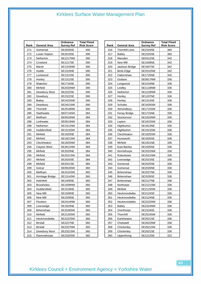
Kirklees Surface Water Management Plan
Kirklees Council + Environment Agency + Yorkshire Water
63
Rank General Area Ordnance Survey Ref
Total Flood Risk Score
Rank General Area
Ordnance Survey Ref
Total Flood Risk Score
271 Gomersal SE2026SE 400
316 Thornhill Lees SE2319SE 360
272 Lower Hopton SE2019SE 396
317 Batley SE2325SE 360
273 Netherton SE1217NW 390
318 Marsden SE0312SE 342
274 Crosland SE1217SE 390
319 New Mill SE1508NE 342
275 Marsh SE1315NW 390
320 Jackson Bridge SE1607SE 342
276 Hudds SE1315NE 390
321 Birds Edge SE2010SW 342
277 Lockwood SE1314SE 390
322 Oakenshaw SE1726NE 340
278 Honley SE1312SE 390
323 Outlane SE0817NW 336
279 Waterloo SE1716SE 390
324 Longwood SE1016NE 336
280 Mirfield SE2020NW 390
325 Lindley SE1118NW 336
281 Dewsbury Moor SE2222SE 390
326 Netherton SE1218NW 336
282 Dewsbury SE2322SE 390
327 Honley SE1207NE 336
283 Batley SE2423SW 390
328 Honley SE1313SE 336
284 Dewsbury SE2421SW 390
329 Scholes SE1626SW 336
285 Thornhill SE2518NW 390
330 Almondbury SE1715SW 336
286 Slaithwaite SE0714SW 384
331 Fenay Bridge SE1715NE 336
287 Meltham SE0910NW 384
332 Stocksmoor SE1810NW 336
288 Linthwaite SE0913NW 384
333 Lepton SE1815SW 336
289 Netherton SE1311NW 384
334 Highburton SE1813NE 336
290 Huddersfield SE1515SW 384
335 Highburton SE1913SW 336
291 Mirfield SE1820NE 384
336 Cleckheaton SE1825SW 336
292 Mirfield SE1821SW 384
337 Hunsworth SE1826SE 336
293 Cleckheaton SE1825NW 384
338 Mirfield SE1921NE 336
294 Clayton West SE2611NW 384
339 East Bierley SE1929SE 336
295 Mirfield SE2020NE 384
340 Norristhorpe SE2022NW 336
296 Mirfield SE2021SW 384
341 Roberttown SE2021NW 336
297 Mirfield SE2020SE 384
342 Liversedge SE2023SE 336
298 Mirfield SE2021SE 384
343 Gomersal SE2025SE 336
299 Golcar SE0918SW 360
344 Gomersal SE2026NE 336
300 Meltham SE1015SW 360
345 Birkenshaw SE2027NE 336
301 Armitage Bridge SE1314SW 360
346 Birkenshaw SE2028SE 336
302 Holmfirth SE1409SE 360
347 Birkenshaw SE2127NE 336
303 Brockholes SE1509NW 360
348 Northorpe SE2121SW 336
304 Huddersfield SE1518NE 360
349 Mirfield SE2119SW 336
305 New Mill SE1509NE 360
350 Heckmondwike SE2124SE 336
306 New Mill SE1509SE 360
351 Heckmondwike SE2124NE 336
307 Flockton SE2414NW 360
352 Heckmondwike SE2222NW 336
308 Liversedge SE1923NE 360
353 Batley SE2324NW 336
309 Birkenshaw SE2028SW 360
354 Overthorpe SE2318SE 336
310 Mirfield SE2120SW 360
355 Thornhill SE2519SW 336
311 Heckmondwike SE2222SW 360
356 Earlsheaton SE2521SE 336
312 Birstall SE2227NE 360
357 Chidswell SE2622NW 336
313 Birstall SE2327NW 360
358 Chickenley SE2621SW 336
314 Dewsbury Moor SE2321SW 360
359 Chickenley SE2621SE 336
315 Ravensthorpe SE2320SW 360
360 Upperthong SE1213SE 322
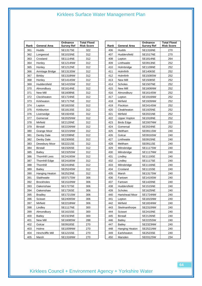
Kirklees Surface Water Management Plan
Kirklees Council + Environment Agency + Yorkshire Water
64
Rank General Area Ordnance Survey Ref
Total Flood Risk Score
Rank General Area
Ordnance Survey Ref
Total Flood Risk Score
361 Hudds SE1317SE 322
406 Hudds SE1316NE 270
362 Longwood SE1015NE 312
407 Huddersfield SE1517NE 270
363 Crosland SE1114NE 312
408 Lepton SE1814NE 264
364 Honley SE1214NW 312
409 Linthwaite SE0913NE 252
365 Honley SE1212NE 312
410 Holmbridge SE1109NE 252
366 Armitage Bridge SE1313SW 312
411 Holmfirth SE1406SE 252
367 Birkby SE1318NW 312
412 Holmfirth SE1508SW 252
368 Honley SE1414SW 312
413 New Mill SE1508SE 252
369 Huddersfield SE1415SW 312
414 Scholes SE1507NE 252
370 Almondbury SE1614NE 312
415 New Mill SE1606NW 252
371 New Mill SE1608NE 312
416 Almondbury SE1614SW 252
372 Cleckheaton SE1724NE 312
417 Lepton SE1916NW 252
373 Kirkheaton SE1717NE 312
418 Mirfield SE1926NW 252
374 Lepton SE1815SE 312
419 Flockton SE2414SW 252
375 Kirkburton SE1813SE 312
420 Cleakheaton SE1925NE 252
376 Liversedge SE1924SE 312
421 Mirfield SE2021NE 252
377 Gomersal SE2025NW 312
422 Upper Hopton SE1918NE 252
378 Mirfield SE2120NE 312
423 Birds Edge SE2007NW 252
379 Birstall SE2226NW 312
424 Gomersal SE2024NE 252
380 Grange Moor SE2215NW 312
425 Meltham SE0911SW 240
381 Denby Dale SE2208NE 312
426 Golcar SE0916SW 240
382 Denby Dale SE2309SE 312
427 Linthwaite SE0915NE 240
383 Dewsbury Moor SE2221SE 312
428 Meltham SE0911SE 240
384 Birstall SE2326SE 312
429 Milnsbridge SE1117SW 240
385 Batley SE2325SW 312
430 Milnsbridge SE1117NW 240
386 Thornhill Lees SE2419SW 312
431 Lindley SE1119SE 240
387 Thornhill Edge SE2418SW 312
432 Lindley SE1117SE 240
388 Thornhill SE2418NE 312
433 Milnsbridge SE1116NE 240
389 Batley SE2524SW 312
434 Crosland SE1115SE 240
390 Hanging Heaton SE2523NE 312
435 Marsh SE1317SW 240
391 Slaithwaite SE0717SW 306
436 Fartown SE1419SW 240
392 Brockholes SE1510NW 306
437 Fartown SE1420NE 240
393 Oakenshaw SE1727SE 306
438 Huddersfield SE1515NE 240
394 Oakenshaw SE1726SE 306
439 Scholes SE1625NE 240
395 Bradley SE1721SW 306
440 Hartshead Moor SE1724NW 240
396 Scisset SE2409SW 306
441 Lepton SE1815NW 240
397 Mirfield SE2218NW 306
442 Mirfield SE1824NW 240
398 Lindley SE1117NE 300
443 Skelmanthorpe SE2310NW 240
399 Almondbury SE1615SE 300
444 Scisset SE2410NE 240
400 Batley SE2323NE 300
445 Birstall SE2126NE 240
401 New Mill SE1608SW 288
446 Batley SE2225SW 240
402 Golcar SE0918SE 270
447 Batley SE2323NW 240
403 Holme SE1009NW 270
448 Hanging Heaton SE2521NW 240
404 Hinchcliffe Mill SE1215SE 270
449 Earlsheaton SE2523SE 240
405 Marsh SE1316NW 270
450 Marsden SE0312SW 234

Kirklees Surface Water Management Plan
Kirklees Council + Environment Agency + Yorkshire Water
65
Rank General Area Ordnance Survey Ref
Total Flood Risk Score
Rank General Area
Ordnance Survey Ref
Total Flood Risk Score
451 Marsden SE0512NE 234
496 Dewsbury SE2321NW 216
452 Marsden SE0612NW 234
497 Thornhill Lees SE2320SE 216
453 Marsden SE0613SE 234
498 Batley SE2424NE 216
454 Slaithwaite SE0716SW 234
499 Batley SE2524NW 216
455 Slaithwaite SE0810NE 234
500 Hanging Heaton SE2521SW 216
456 Golcar SE0915NW 234
501 Earlsheaton SE2520SW 216
457 Linthwaite SE0913SE 234
502 Earlsheaton SE2519NW 216
458 Holmbridge SE1207SW 234
503 Chidswell SE2622SW 216
459 Honley SE1212SE 234
504 Chidswell SE2623SE 216
460 Brockholes SE1410SE 234
505 Lindley SE1118SW 210
461 New Mill SE1606SW 234
506 Lindley SE1118SE 210
462 Almondbury SE1614SE 234
507 Hinchcliffe Mill SE1215NE 210
463 Oakenshaw SE1727NE 234
508 Hinchcliffe Mill SE1214NE 210
464 Stocksmoor SE1809NE 234
509 Birkby SE1319SE 210
465 Thunderbridge SE1811SE 234
510 Huddersfield SE1519SW 210
466 Kirkburton SE1911SW 234
511 Huddersfield SE1517SE 210
467 Shelley SE2010NE 234
512 Almondbury SE1616SW 210
468 Skelmanthorpe SE2311SW 234
513 Almondbury SE1615NE 210
469 Clayton West SE2510SE 234
514 Almondbury SE1716SW 210
470 Cleckheaton SE1926SE 234
515 Hightown SE1724SE 210
471 Shelley SE1910NE 234
516 Dewsbury SE2322SW 210
472 Lepton SE2015SE 234
517 Batley SE2323SE 210
473 Whitley SE2117SE 234
518 Thornhill SE2518SW 210
474 Mirfield SE2121SE 234
519 Outlane SE0816SE 192
475 Whitley Lower SE2217NW 234
520 Linthwaite SE0916SE 192
476 Clayton West SE2211SE 234
521 Longwood SE1015NW 192
477 Skelmanthorpe SE2210NE 234
522 Milnsbridge SE1116NW 192
478 Briestfield SE2317SE 234
523 Honley SE1208SE 192
479 Chickenley SE2620NW 234
524 Netherton SE1308SW 192
480 Longwood SE1016NW 216
525 Netherton SE1311SW 192
481 Meltham SE1010SE 216
526 Holmfirth SE1408NE 192
482 Honley SE1214SW 216
527 Holmfirth SE1407SE 192
483 Armitage Bridge SE1312NW 216
528 Scholes SE1626SE 192
484 Huddersfield SE1519NE 216
529 Scholes SE1624NE 192
485 Bradley SE1720NW 216
530 Cleckheaton SE1725NE 192
486 Shepley SE1909NW 216
531 Kirkheaton SE1718SE 192
487 Cleckheaton SE1825NE 216
532 Mirfield SE1821SE 192
488 Highburton SE1913SE 216
533 Cleckheaton SE1827SW 192
489 Gomersal SE2026SW 216
534 Roberttown SE1922SE 192
490 Birkenshaw SE2128NW 216
535 Roberttown SE1922NE 192
491 Northorpe SE2120NW 216
536 Roberttown SE2022SW 192
492 Heckmondwike SE2223SW 216
537 Gomersal SE2125NW 192
493 Denby Dale SE2308NE 216
538 Batley SE2224SE 192
494 Denby Dale SE2309SW 216
539 Chidswell SE2623SW 192
495 Batley SE2225SE 216
540 Holme SE1011SW 180
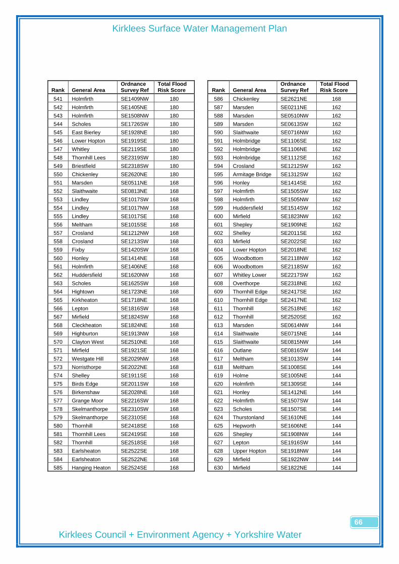
Kirklees Surface Water Management Plan
Kirklees Council + Environment Agency + Yorkshire Water
66
Rank General Area Ordnance Survey Ref
Total Flood Risk Score
Rank General Area
Ordnance Survey Ref
Total Flood Risk Score
541 Holmfirth SE1409NW 180
586 Chickenley SE2621NE 168
542 Holmfirth SE1405NE 180
587 Marsden SE0211NE 162
543 Holmfirth SE1508NW 180
588 Marsden SE0510NW 162
544 Scholes SE1726SW 180
589 Marsden SE0613SW 162
545 East Bierley SE1928NE 180
590 Slaithwaite SE0716NW 162
546 Lower Hopton SE1919SE 180
591 Holmbridge SE1106SE 162
547 Whitley SE2119SE 180
592 Holmbridge SE1106NE 162
548 Thornhill Lees SE2319SW 180
593 Holmbridge SE1112SE 162
549 Briestfield SE2318SW 180
594 Crosland SE1212SW 162
550 Chickenley SE2620NE 180
595 Armitage Bridge SE1312SW 162
551 Marsden SE0511NE 168
596 Honley SE1414SE 162
552 Slaithwaite SE0813NE 168
597 Holmfirth SE1505SW 162
553 Lindley SE1017SW 168
598 Holmfirth SE1505NW 162
554 Lindley SE1017NW 168
599 Huddersfield SE1514SW 162
555 Lindley SE1017SE 168
600 Mirfield SE1823NW 162
556 Meltham SE1015SE 168
601 Shepley SE1909NE 162
557 Crosland SE1212NW 168
602 Shelley SE2011SE 162
558 Crosland SE1213SW 168
603 Mirfield SE2022SE 162
559 Fixby SE1420SW 168
604 Lower Hopton SE2018NE 162
560 Honley SE1414NE 168
605 Woodbottom SE2118NW 162
561 Holmfirth SE1406NE 168
606 Woodbottom SE2118SW 162
562 Huddersfield SE1620NW 168
607 Whitley Lower SE2217SW 162
563 Scholes SE1625SW 168
608 Overthorpe SE2318NE 162
564 Hightown SE1723NE 168
609 Thornhill Edge SE2417SE 162
565 Kirkheaton SE1718NE 168
610 Thornhill Edge SE2417NE 162
566 Lepton SE1816SW 168
611 Thornhill SE2518NE 162
567 Mirfield SE1824SW 168
612 Thornhill SE2520SE 162
568 Cleckheaton SE1824NE 168
613 Marsden SE0614NW 144
569 Highburton SE1913NW 168
614 Slaithwaite SE0715NE 144
570 Clayton West SE2510NE 168
615 Slaithwaite SE0815NW 144
571 Mirfield SE1921SE 168
616 Outlane SE0816SW 144
572 Westgate Hill SE2029NW 168
617 Meltham SE1013SW 144
573 Norristhorpe SE2022NE 168
618 Meltham SE1008SE 144
574 Shelley SE1911SE 168
619 Holme SE1005NE 144
575 Birds Edge SE2011SW 168
620 Holmfirth SE1309SE 144
576 Birkenshaw SE2028NE 168
621 Honley SE1412NE 144
577 Grange Moor SE2216SW 168
622 Holmfirth SE1507SW 144
578 Skelmanthorpe SE2310SW 168
623 Scholes SE1507SE 144
579 Skelmanthorpe SE2310SE 168
624 Thurstonland SE1610NE 144
580 Thornhill SE2418SE 168
625 Hepworth SE1606NE 144
581 Thornhill Lees SE2419SE 168
626 Shepley SE1908NW 144
582 Thornhill SE2518SE 168
627 Lepton SE1916SW 144
583 Earlsheaton SE2522SE 168
628 Upper Hopton SE1918NW 144
584 Earlsheaton SE2522NE 168
629 Mirfield SE1922NW 144
585 Hanging Heaton SE2524SE 168
630 Mirfield SE1822NE 144

Kirklees Surface Water Management Plan
Kirklees Council + Environment Agency + Yorkshire Water
67
Rank General Area Ordnance Survey Ref
Total Flood Risk Score
Rank General Area
Ordnance Survey Ref
Total Flood Risk Score
631 Cleckheaton SE1826SW 144
676 Holme SE1012SW 126
632 East Bierley SE1929SW 144
677 Meltham SE1013NW 126
633 Shelley SE2008NE 144
678 Meltham SE1014NW 126
634 Lepton SE2015SW 144
679 Lindley SE1018NE 126
635 Lepton SE2015NW 144
680 Meltham SE1014NE 126
636 Lwr Cumberworth SE2209SW 144
681 Meltham SE1012SE 126
637 Skelmanthorpe SE2210SE 144
682 Holme SE1006SE 126
638 Flockton SE2314NW 144
683 Holmbridge SE1107NE 126
639 Flockton SE2314NE 144
684 Crosland SE1112NE 126
640 Gomersal SE2026NW 144
685 Holmfirth SE1411SW 126
641 Upper Hopton SE1918SE 144
686 Holmfirth SE1506NW 126
642 Lepton SE2114SE 144
687 Holmfirth SE1507NW 126
643 Grange Moor SE2214NE 144
688 Scholes SE1506SE 126
644 Denby Dale SE2207SE 144
689 Almondbury SE1612NW 126
645 Lower Hopton SE1919NE 138
690 Almondbury SE1613NE 126
646 Marsden SE0412SW 126
691 Farnley Tyas SE1612NE 126
647 Marsden SE0412SE 126
692 Thurstonland SE1610SE 126
648 Marsden SE0515SW 126
693 New Mill SE1608SE 126
649 Marsden SE0516SE 126
694 Jackson Bridge SE1707SE 126
650 Marsden SE0515SE 126
695 Jackson Bridge SE1707NE 126
651 Marsden SE0513SE 126
696 Stocksmoor SE1710NE 126
652 Marsden SE0512SE 126
697 Dalton SE1718SW 126
653 Marsden SE0612SW 126
698 Scholes SE1725NW 126
654 Marsden SE0615SW 126
699 Hightown SE1723SE 126
655 Marsden SE0613NE 126
700 Lepton SE1816NE 126
656 Marsden SE0612SE 126
701 Lepton SE1817NE 126
657 Slaithwaite SE0713SW 126
702 Mirfield SE1822SE 126
658 Slaithwaite SE0714NE 126
703 Kirkburton SE1912SW 126
659 Slaithwaite SE0713SE 126
704 Shepley SE1910SW 126
660 Slaithwaite SE0812NW 126
705 Flockton SE2415SW 126
661 Slaithwaite SE0815SW 126
706 Flockton SE2415SE 126
662 Outlane SE0816NW 126
707 Emley SE2413SW 126
663 Outlane SE0817SW 126
708 Emley SE2412SW 126
664 Outlane SE0816NE 126
709 Denby Dale SE2508NW 126
665 Slaithwaite SE0815SE 126
710 Clayton West SE2511SE 126
666 Slaithwaite SE0813SE 126
711 Clayton West SE2610NW 126
667 Slaithwaite SE0812NE 126
712 Drub SE1926NE 126
668 Slaithwaite SE0811NE 126
713 Shelley SE1908NE 126
669 Meltham SE0912SW 126
714 Upper Hopton SE1917NE 126
670 Golcar SE0917NE 126
715 Birds Edge SE2008NW 126
671 Meltham SE0912SE 126
716 Birds Edge SE2009SW 126
672 Meltham SE0911NE 126
717 Kirkburton SE2012SW 126
673 Holme SE1005NW 126
718 Lepton SE2014NW 126
674 Holme SE1007NW 126
719 Birds Edge SE2107SE 126
675 Holme SE1008SW 126
720 Lepton SE2114SW 126

Kirklees Surface Water Management Plan
Kirklees Council + Environment Agency + Yorkshire Water
68
Rank General Area Ordnance Survey Ref
Total Flood Risk Score
Rank General Area
Ordnance Survey Ref
Total Flood Risk Score
721 Lepton SE2116SE 126
766 Marsden SE0311NE 54
722 Woodbottom SE2117SW 126
767 Marsden SE0410SW 54
723 Emley SE2213NW 126
768 Marsden SE0414NW 54
724 Emley SE2213NE 126
769 Marsden SE0415SW 54
725 Skelmanthorpe SE2210NW 126
770 Marsden SE0415NW 54
726 Denby Dale SE2207SW 126
771 Marsden SE0416SW 54
727 Denby Dale SE2307NE 126
772 Marsden SE0416NW 54
728 Emley SE2313SW 126
773 Marsden SE0416NE 54
729 Denby SE2316SE 126
774 Marsden SE0416SE 54
730 Thornhill SE2517NW 126
775 Marsden SE0415NE 54
731 Thornhill SE2519NE 126
776 Marsden SE0415SE 54
732 Drighlington SE2128SE 120
777 Marsden SE0414NE 54
733 Drighlington SE2227NW 120
778 Marsden SE0412NE 54
734 Birkenshaw SE2128SW 102
779 Marsden SE0510SW 54
735 Heckmondwike SE2122SE 102
780 Marsden SE0512NW 54
736 Birkby SE1320SE 96
781 Marsden SE0513SW 54
737 Fixby SE1419NW 96
782 Marsden SE0513NW 54
738 Almondbury SE1614NW 96
783 Marsden SE0514SW 54
739 Scholes SE1625NW 96
784 Marsden SE0514NW 54
740 Scholes SE1625SE 96
785 Marsden SE0515NW 54
741 Mirfield SE1921NW 96
786 Marsden SE0516SW 54
742 Lindley SE1018SE 90
787 Marsden SE0516NW 54
743 Huddersfield SE1617NW 90
788 Marsden SE0516NE 54
744 Batley SE2523SW 90
789 Marsden SE0515NE 54
745 Batley SE2522NW 90
790 Marsden SE0514NE 54
746 Marsden SE0511SW 72
791 Marsden SE0514SE 54
747 Marsden SE0614NW 72
792 Marsden SE0513NE 54
748 Slaithwaite SE0815NE 72
793 Marsden SE0511SE 54
749 Meltham SE0910SW 72
794 Marsden SE0613NW 54
750 Linthwaite SE0916NE 72
795 Marsden SE0614SW 54
751 Birkby SE1319NE 72
796 Marsden SE0615NW 54
752 Fartown SE1420SE 72
797 Marsden SE0616SW 54
753 Bradley SE1520NE 72
798 Marsden SE0616NW 54
754 Bradley SE1520SE 72
799 Marsden SE0615NE 54
755 Huddersfield SE1519SE 72
800 Marsden SE0615SE 54
756 Almondbury SE1514NE 72
801 Marsden SE0614SE 54
757 Almondbury SE1615SW 72
802 Marsden SE0611NE 54
758 Thurstonland SE1609SE 72
803 Marsden SE0611SE 54
759 Farnley Tyas SE1712NW 72
804 Slaithwaite SE0712SW 54
760 Roberttown SE1923SE 72
805 Slaithwaite SE0714NW 54
761 Gomersal SE2025SW 72
806 Slaithwaite SE0715SW 54
762 Marsden SE0213SE 54
807 Slaithwaite SE0715NW 54
763 Marsden SE0212NE 54
808 Slaithwaite SE0716NE 54
764 Marsden SE0212SE 54
809 Slaithwaite SE0716SE 54
765 Marsden SE0311NW 54
810 Slaithwaite SE0715SE 54

Kirklees Surface Water Management Plan
Kirklees Council + Environment Agency + Yorkshire Water
69
Rank General Area Ordnance Survey Ref
Total Flood Risk Score
Rank General Area
Ordnance Survey Ref
Total Flood Risk Score
811 Slaithwaite SE0712NE 54
856 Honley SE1413SE 54
812 Slaithwaite SE0712SE 54
857 Brockholes SE1410NE 54
813 Slaithwaite SE0711NE 54
858 Holmfirth SE1408SE 54
814 Slaithwaite SE0811SW 54
859 Holmfirth SE1405SE 54
815 Slaithwaite SE0811NW 54
860 Holmfirth SE1506SW 54
816 Slaithwaite SE0812SW 54
861 Newsome SE1511NW 54
817 Slaithwaite SE0813SW 54
862 Huddersfield SE1514NW 54
818 Outlane SE0817SE 54
863 Almondbury SE1514SE 54
819 Slaithwaite SE0814NE 54
864 Brockholes SE1511SE 54
820 Slaithwaite SE0811SE 54
865 Brockholes SE1510SW 54
821 Meltham SE0911NW 54
866 Scholes SE1506NE 54
822 Meltham SE0912NW 54
867 Scholes SE1505NE 54
823 Linthwaite SE0913SW 54
868 Scholes SE1505SE 54
824 Linthwaite SE0914NW 54
869 Thurstonland SE1609NW 54
825 Linthwaite SE0915SW 54
870 Thurstonland SE1610SW 54
826 Golcar SE0916NW 54
871 Thurstonland SE1610NW 54
827 Golcar SE0917SW 54
872 Farnley Tyas SE1611SW 54
828 Golcar SE0917NW 54
873 Scholes SE1725SW 54
829 Golcar SE0917SE 54
874 Drub SE1927SE 54
830 Meltham SE0912NE 54
875 Mirfield SE2219SW 54
831 Holme SE1009SW 54
876 Slaithwaite SE0712NW 42
832 Holme SE1011NW 54
877 Marsden SE0213SW 18
833 Meltham SE1012NW 54
878 Marsden SE0213NW 18
834 Meltham SE1014SE 54
879 Marsden SE0213NE 18
835 Meltham SE1013NE 54
880 Marsden SE0211SE 18
836 Meltham SE1013SE 54
881 Marsden SE0311SW 18
837 Meltham SE1012NE 54
882 Marsden SE0312NW 18
838 Meltham SE1011NE 54
883 Marsden SE0313SW 18
839 Meltham SE1009NE 54
884 Marsden SE0313NW 18
840 Meltham SE1009SE 54
885 Marsden SE0313NE 18
841 Meltham SE1008NE 54
886 Marsden SE0313SE 18
842 Holmbridge SE1107SE 54
887 Marsden SE0312NE 18
843 Holmbridge SE1108SE 54
888 Marsden SE0311SE 18
844 Holmbridge SE1108NE 54
889 Marsden SE0411SW 18
845 Holmbridge SE1109SE 54
890 Marsden SE0412NW 18
846 Holmbridge SE1110SE 54
891 Marsden SE0413SW 18
847 Holmbridge SE1110NE 54
892 Marsden SE0413NW 18
848 Holmbridge SE1111SE 54
893 Marsden SE0414SW 18
849 Holmbridge SE1111NE 54
894 Marsden SE0414SE 18
850 Crosland SE1113SE 54
895 Marsden SE0413NE 18
851 Crosland SE1113NE 54
896 Marsden SE0413SE 18
852 Crosland SE1114SE 54
897 Marsden SE0410SE 18
853 Crosland SE1219SW 54
898 Marsden SE0510NE 18
854 Holmfirth SE1308NE 54
899 Marsden SE0510SE 18
855 Honley SE1413NE 54
900 Marsden SE0611SW 18

Kirklees Surface Water Management Plan
Kirklees Council + Environment Agency + Yorkshire Water
70
Rank General Area Ordnance Survey Ref
Total Flood Risk Score
901 Marsden SE0611NW 18
902 Slaithwaite SE0711SW 18
903 Slaithwaite SE0711NW 18
904 Slaithwaite SE0711SE 18
905 Slaithwaite SE0809SW 18
906 Slaithwaite SE0809NW 18
907 Slaithwaite SE0810SW 18
908 Slaithwaite SE0810NW 18
909 Slaithwaite SE0812SE 18
910 Slaithwaite SE0810SE 18
911 Slaithwaite SE0809NE 18
912 Slaithwaite SE0809SE 18
913 Holme SE1006SW 18
914 Holme SE1006NW 18
915 Holme SE1007SW 18
916 Holme SE1008NW 18
917 Meltham SE1007NE 18
918 Holme SE1007SE 18
919 Holme SE1006NE 18
920 Huddersfield SE1620SW 18
The remaining 700+ "OS Squares" are unscored but have a score of less than 100, assessing them as having insignificant flood risk.

Kirklees Surface Water Management Plan
Kirklees Council + Environment Agency + Yorkshire Water
71
Appendix 2
The Spread of Surface Water Flood Risk across Kirklees
All Areas

Kirklees Surface Water Management Plan
Kirklees Council + Environment Agency + Yorkshire Water
72
Leave page blank for back to back printing

Kirklees Surface Water Management Plan
Kirklees Council + Environment Agency + Yorkshire Water
73
The Spread of Surface Water Flood Risk across Kirklees
50 Highest Risk Areas
Kirklees Surface Water Management Plan
Kirklees Council + Environment Agency + Yorkshire Water
74
Leave page blank for back to back printing
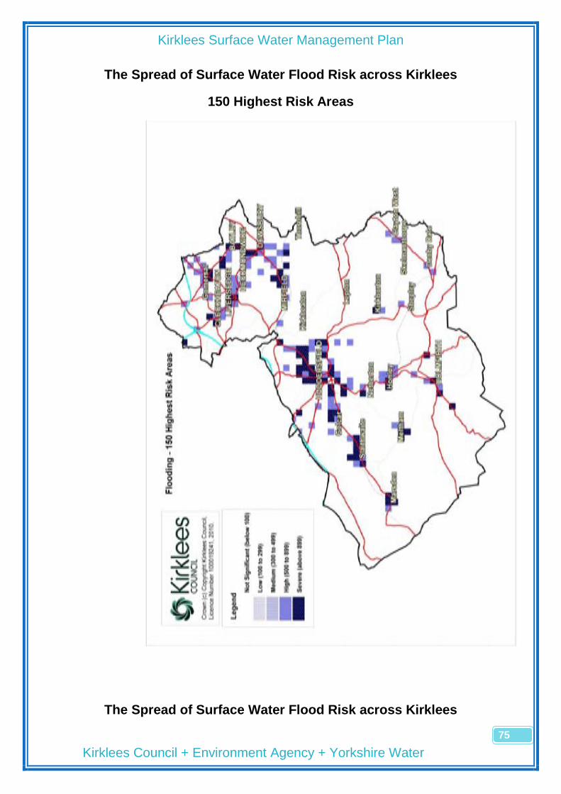
Kirklees Surface Water Management Plan
Kirklees Council + Environment Agency + Yorkshire Water
75
The Spread of Surface Water Flood Risk across Kirklees
150 Highest Risk Areas
The Spread of Surface Water Flood Risk across Kirklees
Kirklees Surface Water Management Plan
Kirklees Council + Environment Agency + Yorkshire Water
76
Leave page blank for back to back printing
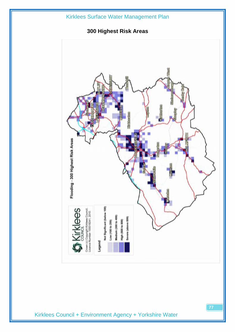
Kirklees Surface Water Management Plan
Kirklees Council + Environment Agency + Yorkshire Water
77
300 Highest Risk Areas

Kirklees Surface Water Management Plan
Kirklees Council + Environment Agency + Yorkshire Water
78
Leave page blank for back to back printing

Kirklees Surface Water Management Plan
Kirklees Council + Environment Agency + Yorkshire Water
79
Appendix 3
Assessment Report Template
(Worked Example)

Kirklees Surface Water Management Plan
Kirklees Council + Environment Agency + Yorkshire Water
80
Leave page blank for back to back printing

Kirklees Surface Water Management Plan
Kirklees Council + Environment Agency + Yorkshire Water
81
Appendix 4 (Worked Example)
Priority Measures Template
OS Square Ref: SE1417SE
Location: Gt. Northern St Gyratory, Huddersfield TC
Assessment Date: 19 November 2010
Assessment By: Tom Ghee
Ref. Priority Measure Details
A 1 Flood Warning Carry out desktop and site survey to highlight vulnerable properties eg low thresholds, on predicted flow paths, low-spots around building doors with risk of blocked drainage. Standard letter to highlight that their property may be in a predicted surface water flood zone. Bespoke letters to offer additional advice around threshold protection (ref F), private drainage maintenance (ref J).
B 1 Development Control Large commercial sites to be monitored through planning process. Potential for future SUDS approach and higher floor levels. Seems to be little opportunity to explore combined sewer separation. Real opportunities for storage and discharge control above the area of predicted flooding around the gyratory.
C 1 Resilience/ Resistance (New) Use planning opportunities to encourage resilience measures to vulnerable properties, particularly basements in terraced housing on Lwr Fitzwilliam St and William St
D 4 Brownfield Development Opp. Take opportunities through the Tesco redevelopment to improve capacity in existing drainage systems. Ex Grahams development in low spot is very vulnerable to flooding, consider raised floors in any future redevelopment proposals. Similarly, car park off Gasworks Street is vulnerable to flooding if redeveloped, unless connection to the canal is permitted.
E 4 Permeable Paving Retrofit not feasible but opportunities through redevelopment to encourage permeable paving to retail park car parks.
F 6 Threshold Raising Not feasible unless redevelopment occurs
G 6 Green Roofs Possibilities if retail parks developed but would require a change in design philosophy on lightweight roofs
H 8 Flow Paths Site inspection shows predicted flow route towards Perrys is probably inaccurate, more likely to flow down Lwr Fitzwilliam St. May be an opportunity to negotiate an overflow route into the canal.
I 9 Further Modelling Depth and velocity details would be useful. Inconsistency between EA Surface Water maps and SFRA Surface Water maps. Modelling required (possibly at developers expense) if we want to specify floor levels.
J 9 Improve Maintenance Private drainage maintenance addressed in Ref A. Gyratory vulnerable to flooding – consider increased maintenance of gullies and Beany Blocks. Need to investigate any reoccurring YW issues.
K 9 Resilience/ Resistance (Existing)
Need to highlight to terraced housing the risks of using basements for habitable accommodation and measures that can be taken to recover quickly from flooding.

Kirklees Surface Water Management Plan
Kirklees Council + Environment Agency + Yorkshire Water
82