kanchipuram district
TRANSCRIPT

1
KANCHIPURAM
DISTRICT

2
KANCHIPURAM DISTRICT
1. Introduction
i) Geographical location of the district
Kanchipuram district is situated on
the Northern East Coast of Tamil Nadu and
is bounded in the West by Vellore and
Thiruvannamalai districts, in the North by
Tiruvallur district and Chennai district, in
the South by Villuppuram district and in the
East by the Bay of Bengal. It lies between
11° 00' to 12° 00’ North and 77° 28' to
78° 50' East. The district has a total
geographical area of 4,393.37 sq.km and
coastline of 57 km Kanchipuram, the temple
town is the district headquarters.
i) Administrative profile
For administrative reasons, the
district has been divided into 4 revenue
divisions comprising of 11 taluks with 1,137
revenue villages. For development reasons,
it is divided into 13 development blocks
with 648 village panchayats.
iii) Meteorological information
The pre-monsoon rainfall is almost
uniform throughout the district. The coastal
taluks get more rains rather than the interior
regions. This district is mainly depending on
the seasonal rains. Northeast and southwest
monsoons of contribute respectively to the
total annual rainfall. The normal rainfall of
the district has been 1213.3 mm and actual
rainfall has been 1133 mm. The months
between April and June are generally hot
with temperatures going up to an average
maximum of 36.6ºC. In winter (December -
January) the average minimum temperature
is 19.8ºC.
2. Resources availability
i) Land resources
The following table shows the soil
types in the district.
Type of soil Places in district
Red Loam Kanchipuram,
Uthiramerur blocks
Lateritic Soil Plateau in the district
Black Soil Spread in all blocks
Sandy Coastal
Alluviam
Thirukazhukundram,
Thiruporur,
St.Thomas Mount.
Red Sandy Soil Kanchipuram,
ii) Agriculture and horticulture
Agriculture is the main occupation of
the people with 47% of the population

3
engaged in it. Paddy is the major crop
cultivated in this district. Groundnuts,
Sugarcane, Cereals & Millets and Pulses are
the other major crops cultivated. Palar River
along with Tanks and wells are the main
sources of irrigation in this district.
Following table shows the details of
agriculture in the district.
Classification Area in ha
Total Cropped
Area 1,98,543
Net Area Sown 1,60,090
Area sown more
than once 38,453
Area Under Principal Crops
Rice 1,45,966
Millets and
Cereals 1,217
Pulses 2,966
Sugarcane 7,586
Groundnut 28,766
Gingelly 912
Cotton 53
iii) Forest resources
The total forest area in the district is
23,586 ha spread in the interior regions of
the district. In this 366.675 ha are Reserved
Land. Much of the natural forests have been
converted into man-made forests since the
late 1950s. However, chunks of natural
forests still exist in Hanumanthaputheri,
Maiyur and parts of Kelambakkam R.F.
which still support the original vegetation.
Kanchipuram district has the singular
distinction of having established woodlots in
community (Poramboke) lands vested with
the panchayat. Way back in 1961, the first
ever community plantation- the precursor of
the present day social forestry was raised
near Sunguvarchatram in panchayat lands.
The major forest product, the
industrial pulpwood obtained from
Eucalyptus plantations, is supplied for paper
manufacturing. The lops and tops left after
extracting the pulpwood is sold as fuel
wood. Fuel wood is extracted also from the
Casuarina plantations. Cashew is the
important Non Timber Forest Produce
which contributes a major share of forest
revenue.
iv) Mineral resources
Granite, stone quarry, sand quarry,
silica sand and clay are the minerals
available in Kanchipuram district. Following
table shows the availability of mineral
resources.
Estimated Availability of Mineral
resources
Sl.
No.
Name of the
mineral
Estimated
Availability (in
metric tonnes)
1. Silica Sand 6,00,000
2. White Clay 5,00,000
3. Black Granite 3,75.000
4. Stone 75,00,000
5. Sand 45,00,000
v) Water resources
River Palar is the main river in the
district, which is not perennial. This is the
only river that flows thorough the district,
originating from Nandhi Durg in Karnataka.
It runs through for a length of 350 km and
nearly half of it in this district covering a
basin area of 2187 sq.km The river has part
of its basin in Karnataka and Andhra states.
Most of the year it remains dry, due
to the construction of dams across the river
in Andhra Pradesh. Cheyyar and Vegavathy
rivers are tributaries of Palar and join it at
Thirumakkudal.

4
vi) Fisheries production
The Kanchipuram District is rich in
fish resources. Scope for exploitation of
marine fisheries in the District is high with
the coastal line of 57 km A comparison of
fish production indicates that the coastal
production is higher than the inland fish
production. The fish production from both
inland and marine sources has increased in
both quantity and value.
vii) Heritage sites
Kanchipuram
Kanchipuram is known as the "city
of a thousand temples". The 192 ft high
temple tower of Ekamabaranadhar temple
and the 100-pillar mandabam (building) in
Varadaraja Perumal temple in this town are
famous, and are considered marvels of the
architectural beauty of the Vijayanagara
dynasty. The British Viceroy Robert Clive,
who is responsible for the British rule in
India, had exclaimed the architectural beauty
of Varadharaja perumal temple and
presented a fabulous jewelry to this temple.
Today, apart from its temples, this small
town is also known for its thriving
handloom industry. The city is quite famous
for its silk sarees, considered to be one of
the best varieties of silk sarees. Walajapet
near Kanchipuram is also famous for silk
saree weaving.
Vedanthangal
Vedanthangal is one of India's main
water-bird sanctuaries situated at a distance
of 48 km from Kanchipuram. Storks, egrets,
cormorants, darters, flamingos, pelicans,
moorhens, herons, kingfishers, sandpipers,
white ibis, spoonbills, swans and grey
wagtails are some of the birds also which
visit seasonally. Between October and
March, many migratory birds visit. The
birds can be viewed from the bank or from
the watch tower.
Vedanthangal water-bird sanctuaries
Muttukadu
Muttukadu is a large lake formed out
of the backwaters from Bay of Bengal. It has
boating and wind surfing facilities. It is
located at a distance of 80 km from
Kanchipuram. The backwaters of
Muttukkadu have been developed by the
Tamil Nadu Tourism Development
Corporation to serve as a picnic spot and a
center for water sports. Training and
demonstration programmes are also
organised for beginners.
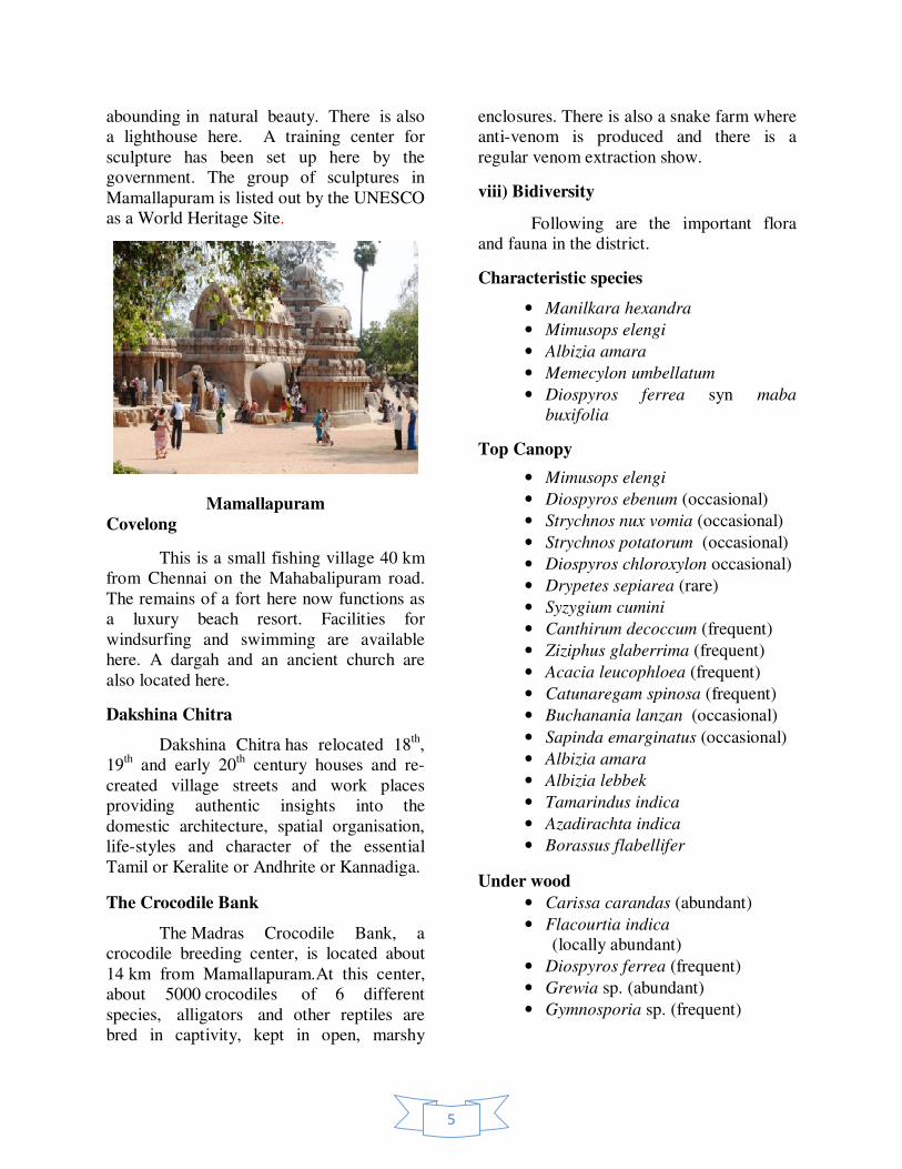
Mamallapuram
It is a place of architectural interest
and lies on the east coast, 55 km south of
Chennai. It is an important tourist center.
The shore temple and the monolithic
chariots, known as the “Five Rathas”,
Arjuna’s peanace, the Krishna Mandapam,
Mahishasura Mandapam, the elephant etc.,
are all magnificent pieces of sculpture which
attract hundreds of tourists throughout the
year. The place is also known as the Seven
Pagodas and along with the sea-shore and its
temple provides a beautiful picnic spot
5
abounding in natural beauty. There is also
a lighthouse here. A training center for
sculpture has been set up here by the
government. The group of sculptures in
Mamallapuram is listed out by the UNESCO
as a World Heritage Site.
Mamallapuram
Covelong
This is a small fishing village 40 km
from Chennai on the Mahabalipuram road.
The remains of a fort here now functions as
a luxury beach resort. Facilities for
windsurfing and swimming are available
here. A dargah and an ancient church are
also located here.
Dakshina Chitra
Dakshina Chitra has relocated 18th,
19th and early 20
th century houses and re-
created village streets and work places
providing authentic insights into the
domestic architecture, spatial organisation,
life-styles and character of the essential
Tamil or Keralite or Andhrite or Kannadiga.
The Crocodile Bank
The Madras Crocodile Bank, a
crocodile breeding center, is located about
14 km from Mamallapuram.At this center,
about 5000 crocodiles of 6 different
species, alligators and other reptiles are
bred in captivity, kept in open, marshy
enclosures. There is also a snake farm where
anti-venom is produced and there is a
regular venom extraction show.
viii) Bidiversity
Following are the important flora
and fauna in the district.
Characteristic species
• Manilkara hexandra
• Mimusops elengi
• Albizia amara
• Memecylon umbellatum
• Diospyros ferrea syn maba
buxifolia
Top Canopy
• Mimusops elengi
• Diospyros ebenum (occasional)
• Strychnos nux vomia (occasional)
• Strychnos potatorum (occasional)
• Diospyros chloroxylon occasional)
• Drypetes sepiarea (rare)
• Syzygium cumini
• Canthirum decoccum (frequent)
• Ziziphus glaberrima (frequent)
• Acacia leucophloea (frequent)
• Catunaregam spinosa (frequent)
• Buchanania lanzan (occasional)
• Sapinda emarginatus (occasional)
• Albizia amara
• Albizia lebbek
• Tamarindus indica
• Azadirachta indica
• Borassus flabellifer
Under wood
• Carissa carandas (abundant)
• Flacourtia indica
(locally abundant)
• Diospyros ferrea (frequent)
• Grewia sp. (abundant)
• Gymnosporia sp. (frequent)
6
• Ixora arborea (frequent)
• Tarenna ascatica (frequent)
• Memecylon umbellatum
• Garcinia spicata
Shrubs
• Strobilanthus
• Dodonaea viscosa (abundant)
• Glycosmis pentaphylla
• Ochna squarrosa
• Gmelina asiatica
Herbs
• Hemidesmus indicus
Tropical dry evergreen scrubs
• Diospyros ferrea
• Ziziphus glaberrima
• Calliea cinerea
• Catunaregam spinosa
• Carissa spinarum
• Albiziz amara
• Buchanania lanzan
• Dodonaea viscosa
Thorn forests
• Karunkali - Acacia chundra
• Usil - Albizia amara
• Neem - Azaridachita indica
• Sarakonnai - Cassia fistula
• Namai - Anogeissus latifolia
• Karai - Randia dumentorum
• Vagai - Albizia odaratissma
• Kala - Carisa carandas
• Etti - Strychnos nuxvomica
• Virali - Dodonaea viscosa
• Avaram - Cassia auriculata
• Canthum dicoccum
• Aristida setaca
• Heteropogon contortus.
Fauna
• Jackal - Canis aureus
• Jungle cat - Felis chaus
• Palm squirrels - Funambulus
pennanti and F.palmarum
• Hare - Lepus nigricollis nigricollis
• Common mongoose - Harpestes
edwardsi
• Shrew - Suncus sp.
• Pangolim - Manis crassicaudata.
• Pariyakite - Milvus migrans govinda
• Brahminy kite - Haliastuf indus
• Patridge - Francolinus pondicerianus
• Koel - Eudynamys scolopacea.
• Spotted owlet - Athene brahma
• Common rat snake - Ptyas mucosus
• Cobra - Naja naja
• Green whip snake - Ahaetulla
nasutus.
3. Impacts
i) Urbanization
The proportion of urban population
to total population has increased over the
decades in the district. Acceleration in
density of population is felt heavily in
urban areas. The decadal growth rate
indicates that the urban centers have
increased in the district adding
enormously on the urban population.
The estimated sewage generation is at
383.33 lakh liters per day in urban areas
with a breakup of 222.10 lakh liters per
day for municipalities and 161.23 lakh
liters per day for town panchayats.
Underground drainage system is
available in Kanchipuram,
Maraimalainagar and Uthiramerur.
Overall solid waste generated in the
district adds up to 437.14 tonnes with a
break-up of 379.00 tonnes in
municipalities and 58.14 tonnes in town
panchayats. The primary component of
the waste is compostable matter
constituting 86% in the total waste.
7
ii) Industrial development
One of the largest industrial areas of
Tamil Nadu, Kanchipuram has the pride in
being home to vital production bases of
international industrial groups like, Ford,
Hyundai, Saint Gobain as well as many
export houses in and around the Madras
Export Processing Zone. The reasons for
this are not far to seek:
• Proximity to the Chennai urban area
• Proximity to an international airport
and two sea ports at Chennai and
Ennore
• Excellent connectivity through
the world class East Coast Road and
upcoming upgraded NH4 & NH45
• Moderate cost of land
• Good industrial parks at Maraimalai
Nagar, Alanthur, Irungattukottai, Sri-
perumbudur, Siruseri, Oragadam
and Paranur
• Reasonably good power supply with
the North Madras Power Station and
Kalpakkam Atomic Power Station
located in and around the District.
• Availability of skilled and highly
qualified manpower at Chennai and
suburbs with IIT, Chennai and Anna
University .
iii) Thermal power generation
The only power project available in
the district of Kanchipuram is the atomic
power plant which is located in Kalpakkam.
iv) Natural hazards
As any other coastal environment,
coast of Kanchipuram district also gets
affected with regular erosion and accretion.
Sea level rise and elevation in sea surface
temperature are also seen here as the
consequences of global climate change.
v) Natural disaster prone areas
Information on drought, flood and
cyclone in the district is very limited.
However, it has been ascertained from the
available information that there had been
cyclones in 1985-86 and 1992-93. As a
consequence flood has occurred during the
above years. The north east monsoon
contributes more rainfall than the south west
monsoon. Generally flood occurs during
north east monsoon as there is heavy down
pour coupled with cyclonic storm formed in
Bay of Bengal. Floods occur in the zones
such as Upper Cheyyar and Kiliyar of Palar
basinches Heavy floods had occurred in
1985, causing heavy damages to
Maduranthagam tank and washing away of
Kiliyar Railway Bridge and NH Road
Bridge. There were also floods during
1992-1993 causing heavy damages to lives
and properties. The cyclonic storm which
crossed the coast at Karaikal on 4.12.93 had
caused substantial damages in the basin
area. Several hectares of crops were also
damaged due to the flood.
Kovalam
The stretch of the coast from
Kovalam upto Chinnakuppam is a bay like
formation. This bay formation is likely due
to the outcrops on its south acting as a
natural littoral barrier. A significant stretch
of coast south of Kovalam has a wide beach
conducive for plantations as a long-term
measure for protecting the coast.

8
4. Government initiatives
i) Coastal protection initiatives
Devaneri
This stretch of the coast has a flat
beach. However, in the vicinity of this coast,
a large number of dwelling units has
suffered damages due to the tsunami. This
stretch of the coast can be protected with a
flat seawall with a higher crest elevation for
0.5 km backed up by plantations in between
the dwelling units and the crown of the
seawall. On the south of Devaneri, existing
plantations act as barriers in reducing the
tsunami run-up. Hence, Devaneri stretch of
the coast can be protected by combination of
rubble mound seawall and plantations.
Mamallapuram
In the coastal stretch between
Devaneri and Mamallapuram, the shoreline
undergoes short-term changes and hence this
stretch of the coast need not be considered
for putting up any hard structures and only
plantations could be taken up as a long-term
solution.
Meyyur Kuppam and Sadras kuppam
This village lies south of Kalpakam
Atomic Power Station. The impact of
tsunami was severe in this stretch. In the
immediate south of this village, presence of
coconut plantations gave slight relief, as the
land in this area is not in an elevated
location. During tsunami the water level
rose by 3 m and penetrated into land. This
stretch of the coast has a number of houses,
which need to be protected.
Oyyalikuppam
A number of dwelling units adjacent
to the coast has been washed away due to
tsunami. This village is situated north of
Palar River. The Palar River traps some of
the sediment transport directed towards
North leading to a deficit of sediment
supply, leading to erosion along this stretch
of the coast.
ii) Awareness initiatives
There are at least eight environment
NGOs dealing with environmental
awareness programs and cleaning campaign.
Various awareness creation activities have
been made among the fisher folk on tsunami
and Coastal Regulation Zone issues by
different Government and Non Government
organizations. Attempts have been made to
develop bioshields, rebuild livelihoods,
establish the 'Village Knowledge Centres'
and reclaim soil in the tsunami affected
agricultural fields in Kanchipuram district.
5. Summary / Conclusion
• Kanchipuram district is situated on
the Northern East Coast of Tamil
Nadu and is adjacent by Bay of
Bengal.
• The district has a total geographical
area of 4,393.37 sq.km and coastline
of 57 km.
• For administrative reasons, the
district has been divided into 4
revenue divisions comprising of 11
taluks with 1,137 revenue villages.

9
• For development reasons, it is
divided into 13 development blocks
with 648 Village Panchayats.
• Agriculture is the main occupation of
the people with 47% of the
population engaged in it.
• Paddy is the major crop cultivated in
this district. Groundnuts, Sugarcane,
Cereals, Millets and Pulses are the
other major crops cultivated.
• The total forest area in the district is
23,586 ha, spread over the interior
regions of the district. In this forest
area there are 366.675 ha of
Reserved Land.
• Palar is the major river in the district,
which is not perennial. This is the
only river that flows thorough the
district, originating from Nandhi
Durg in Karnataka.
• The Kanchipuram District is rich in
fishing resources. Potential for
exploitation of marine fisheries in
the District is high with a coastal line
of 57 km.
• The proportion of urban population
to total population has increased over
the decades in this district.
• One of the largest industrial areas of
Tamil Nadu, Kanchipuram has the
pride in being home to vital
production bases of international
industrial groups
• The only power project available in
the district of Kanchipuram is the
atomic power plant which is located
in Kalpakkam.