juneau, ak 99802 habitat conservation division nmfs...juneau, ak 99802 telephone: ... in our...
TRANSCRIPT
Juneau Hydropower, Inc. PO Box 22775
Juneau, AK 99802 www.juneauhydro.com
Telephone: (907) 789-2775 Fax: (907) 375-2973
October 19, 2012 sent via e-mail Susan H. Walker, Hydropower Coordinator Habitat Conservation Division National Marine Fisheries Service (“NMFS”) P.O. Box 21109 Juneau, AK 99802 RE: Sweetheart Lake Hydroelectric Project request for finding of no adverse effect on Essential Fish Habitat Dear Ms. Walker, In our previous letter, dated August 23, 2012, Juneau Hydropower, Inc. (“JHI”) requested that a determination be made by NMFS of no significant impact be determined with the proposed operations of the Sweetheart Lake Hydroelectric Project (“Project”) as proposed in our Draft License Application (“DLA”) and Preliminary Draft Environmental Assessment (“PDEA”). In error I used the wrong language in that I should have requested that NMFS determine a “finding of no adverse effect” on Essential Fish Habitat. This letter requests that NMFS issue a finding of “no adverse effect” on Essential Fish Habitat with regards to our proposed operations of the Sweetheart Lake Hydroelectric Project. Below I explain why our proposed operations, in effect, “enhance” the Essential Fish Habitat as constructed in the language and intent of the Magnuson Stevens Act. I have reviewed the statutory language and authority of NMFS related to Essential Fish Habitat that is found in the Magnuson Stevens Fishery Conservation and Management Act as Amended through January 12, 2007 (“Act”) and find the relevant section is 305 (b) which reads: FISH HABITAT.— (1) (A) The Secretary shall, within 6 months of the date of enactment of the Sustainable Fisheries Act, establish by regulation guidelines to assist the Councils in the description and identification of essential fish habitat in fishery management plans (including adverse impacts on such habitat) and in the consideration of actions to ensure the conservation and enhancement of such habitat. The Secretary shall set forth a schedule for the amendment of fishery management plans to include the identification of essential fish habitat and for the review and updating of such identifications based on new scientific evidence or other relevant information. (B) The Secretary, in consultation with participants in the fishery, shall provide each Council with recommendations and information regarding each fishery under that Council's authority to assist it in the identification of essential fish habitat, the adverse impacts on that habitat, and the actions that should be considered to ensure the conservation and enhancement of that habitat. (C) The Secretary shall review programs administered by the Department of Commerce and ensure that any relevant programs further the conservation and enhancement of essential fish habitat. (D) The Secretary shall coordinate with and provide information to other Federal agencies to further the conservation and enhancement of essential fish habitat.
2
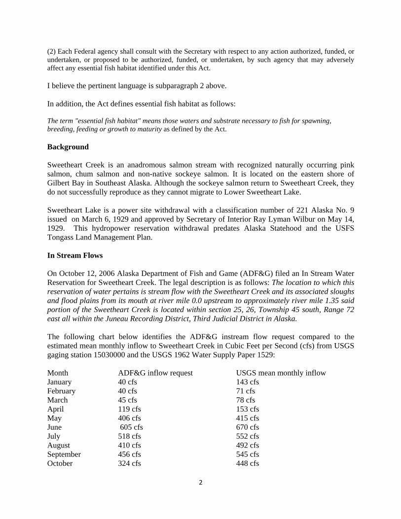
(2) Each Federal agency shall consult with the Secretary with respect to any action authorized, funded, or undertaken, or proposed to be authorized, funded, or undertaken, by such agency that may adversely affect any essential fish habitat identified under this Act. I believe the pertinent language is subparagraph 2 above. In addition, the Act defines essential fish habitat as follows: The term "essential fish habitat" means those waters and substrate necessary to fish for spawning, breeding, feeding or growth to maturity as defined by the Act. Background Sweetheart Creek is an anadromous salmon stream with recognized naturally occurring pink salmon, chum salmon and non-native sockeye salmon. It is located on the eastern shore of Gilbert Bay in Southeast Alaska. Although the sockeye salmon return to Sweetheart Creek, they do not successfully reproduce as they cannot migrate to Lower Sweetheart Lake. Sweetheart Lake is a power site withdrawal with a classification number of 221 Alaska No. 9 issued on March 6, 1929 and approved by Secretary of Interior Ray Lyman Wilbur on May 14, 1929. This hydropower reservation withdrawal predates Alaska Statehood and the USFS Tongass Land Management Plan. In Stream Flows On October 12, 2006 Alaska Department of Fish and Game (ADF&G) filed an In Stream Water Reservation for Sweetheart Creek. The legal description is as follows: The location to which this reservation of water pertains is stream flow with the Sweetheart Creek and its associated sloughs and flood plains from its mouth at river mile 0.0 upstream to approximately river mile 1.35 said portion of the Sweetheart Creek is located within section 25, 26, Township 45 south, Range 72 east all within the Juneau Recording District, Third Judicial District in Alaska. The following chart below identifies the ADF&G instream flow request compared to the estimated mean monthly inflow to Sweetheart Creek in Cubic Feet per Second (cfs) from USGS gaging station 15030000 and the USGS 1962 Water Supply Paper 1529: Month ADF&G inflow request USGS mean monthly inflow January 40 cfs 143 cfs February 40 cfs 71 cfs March 45 cfs 78 cfs April 119 cfs 153 cfs May 406 cfs 415 cfs June 605 cfs 670 cfs July 518 cfs 552 cfs August 410 cfs 492 cfs September 456 cfs 545 cfs October 324 cfs 448 cfs

3
November 117 cfs 290 cfs December 117 cfs 187 cfs
On August 7, 2012, JHI filed for an application of Water Right for Sweetheart Lake and Sweetheart Creek with the Alaska Department of Natural Resources (“ADNR”). Under the type of use section of the application, JHI listed hydropower project as use and would use more than 1,000,000 gallons annually for ADNR fee purposes. JHI also noted that it would use 300 to 335 cfs for normal operations with turbine capacity up to 486 cfs for high water events and/or if there is an emergency demand for power in Juneau. Essential Fish Habitat The habitat for spawning, breeding, feeding or growth to maturity to include areas above and below the barrier reach were investigated and documented by JHI during the 2011 and 2012 study seasons.
0100200300400500600700
Janu
ary
Febr
uary
M
arch
Ap
ril
May
Ju
neJu
ly
Augu
st
Sept
embe
r O
ctob
er
Nov
embe
r
Dece
mbe
r
ADF&G inflow request
USGS mean monthly inflow

4
Photo of Anadromous Reach 1 and Reach 2 Habitats of Sweetheart Creek Reach 1 between tidal reach and barrier falls. The first two waterfalls at 22 and 28 ft elevation do not prevent fish passage, but the next at 46ft does inhibit upstream migration. The 86 ft. falls is the barrier falls whereby no anadromous fish pass. Elevations are from a topographic survey by Max A. Schillinger of Palmer, Alaska, a registered professional land surveyor with extensive experience in coastal marine and tideland surveys. Lower transects for instream flow study shown in pink.

5
Table of Reach Habitat identification and quantification
Table 1Reach Location Distance Habitat Type Length (m) Width (m) Area (m2)Gradient (%)Depth (m)SubstrateTidal 57.943592, 133.690609 0 Riffle 131 33 4323 1
131 Riffle 100 30 3000 1 3 to 6 inch231 Riffle 20 20 400 1 3 to 6 inch231 Pool 20 10 200 1251 Fast Riffle 30 20 600 1 4 to 6 inch281 Riffle 30 36 1080 1 2 to 4 inch311 Riffle 40 41 1640 1 0.3 to 0.9 2 to 8 inch351 end riffle
Total 11243
Reach 1 351 Macro Pool 35 29 1015 1 7 3-5 inch386 2m high Falls 12 22 264 42398 Side Riffle 30 7.5 225 2 3 to 4 inch428 Side Riffle 22 7 154 2 3 to 4 inch398 Macro Pool 24 23 552 1 3 to 5 inch415 Side Pool 12 6 72 0.6 Bedrock, boulder422 3m high Falls 22 23 506 14440 Side Pool 5 5 25 1.8444 Macro Pool 30 29 870 1 Bedrock444 Side Pool 15 20 300 1 Bedrock, boulder444 Side Pool 10 5 50 1 Bedrock474 Cascade 10 15 150 Bedrock
57.944296, 133683162 484 Barrier Falls 0Total 4183
0Reach 2 0 Fast Riffle 40 20 800 3.5
10 Side Pool 4 3 12 0.657.944320, 133.683470 20 Side Pool 6 5 30Large wood 35 Side Pool 5 4 20 1Large wood 40 Fast Riffle 45 14 630 3.5
40 Macro Pool 7 7 4970 Side Pool 4 3 12 1.280 Side Pool 6 4 24 1.2
Log across channel 85 Fast Riffle 36 20 720 3.5121 Shallow Riffle 40 10 400121 Side Pool 7 7 49128 Side Pool 7 7 49161 Fast Riffle 11 20 220 3.5
Gravel bar on bend 172 Fast Riffle 12 20 240 3.5172 Side Pool 4 3 12 0.3184 Fast Riffle 39 20 780
57.94381, 133.68066 223 Macro Pool 20 20 400 2.4243 Fast Riffle 30 10 300 3.5
Bedrock outcrop 273 Fast Riffle 25 20 500 3.5Large wood 303 Side Pool 25 6 150 1.2
303 Fast Riffle 20 14 280 3.5 6 to 8 inch328 Cascade 12 >4
Total 5677

6
Lower Sweetheart Creek, Tidal Reach, Reaches 1, 2, and 3. Water Quality Federal Water Quality Standards
According to the USFS Gilbert Bay/Holkam Bay FEIS conducted in the area in 1980, the water quality is good throughout the study area and is similar to other non-glacial streams in Southeast Alaska.
Steep side-slope V-notch drainage channel most of the surface water flow to the bottomlands. These ravines often have bedrock-controlled channels averaging 25 feet in width and are 1.5 to 5 feet deep at the bankfull depth. These ravines characteristically have a steep gradient, with numerous cascades and small waterfalls. Flow velocity may reach ten feet per second. Shallow mass wasting of soil and weathered rock fragments on ravine side-slopes is a common natural erosion process that delivers sediment to these channels. This sediment is often deposited at the toe of the valley side-slopes as small alluvial fans.1
1 USFS FEIS 10038001 Proposed Recreational Development and Independent Timber Sale Gilbert Bay/Holkam Bay 1980.
Tidal Reach Barrier Falls
Reach 3 begins
Reach 1 begins
Reach 2 begins

7
Because there is not a current identified potential for domestic/commercial water uses in and near Sweetheart Creek, Gilbert Bay is unlikely that state and federal water quality criteria apply. Because there are no domestic or industrial water uses in any of the affected watershed, lakes or creek, no specific water quality standards (such as those for drinking water or industrial discharge) are currently in effect relative to specific uses.
However, certain state and federal water quality criteria apply regardless of existing or proposed uses. Further any proposed degradation to water quality could impact essential fish habitat under the Act.
Water quality sampling results from 2012 are shown in the table below
Water Quality Data 2012 (Source: E. Flory Fish Report 2012)
8
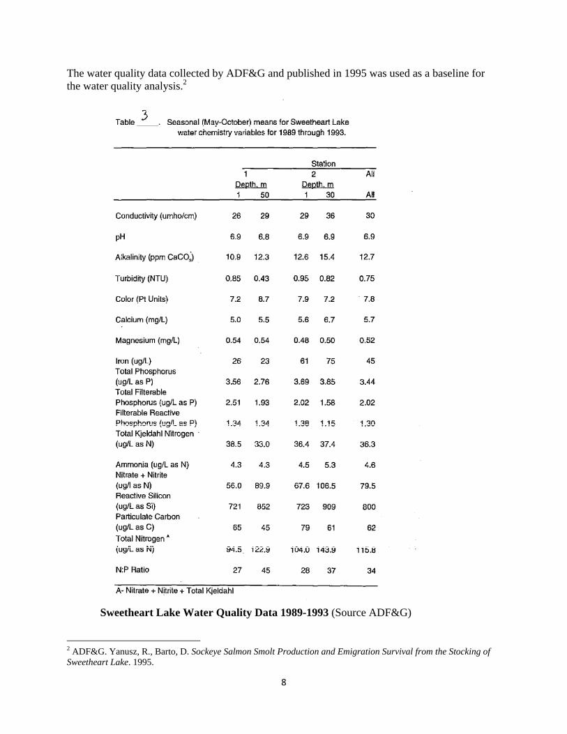
The water quality data collected by ADF&G and published in 1995 was used as a baseline for the water quality analysis.2
Sweetheart Lake Water Quality Data 1989-1993 (Source ADF&G)
2 ADF&G. Yanusz, R., Barto, D. Sockeye Salmon Smolt Production and Emigration Survival from the Stocking of Sweetheart Lake. 1995.
9
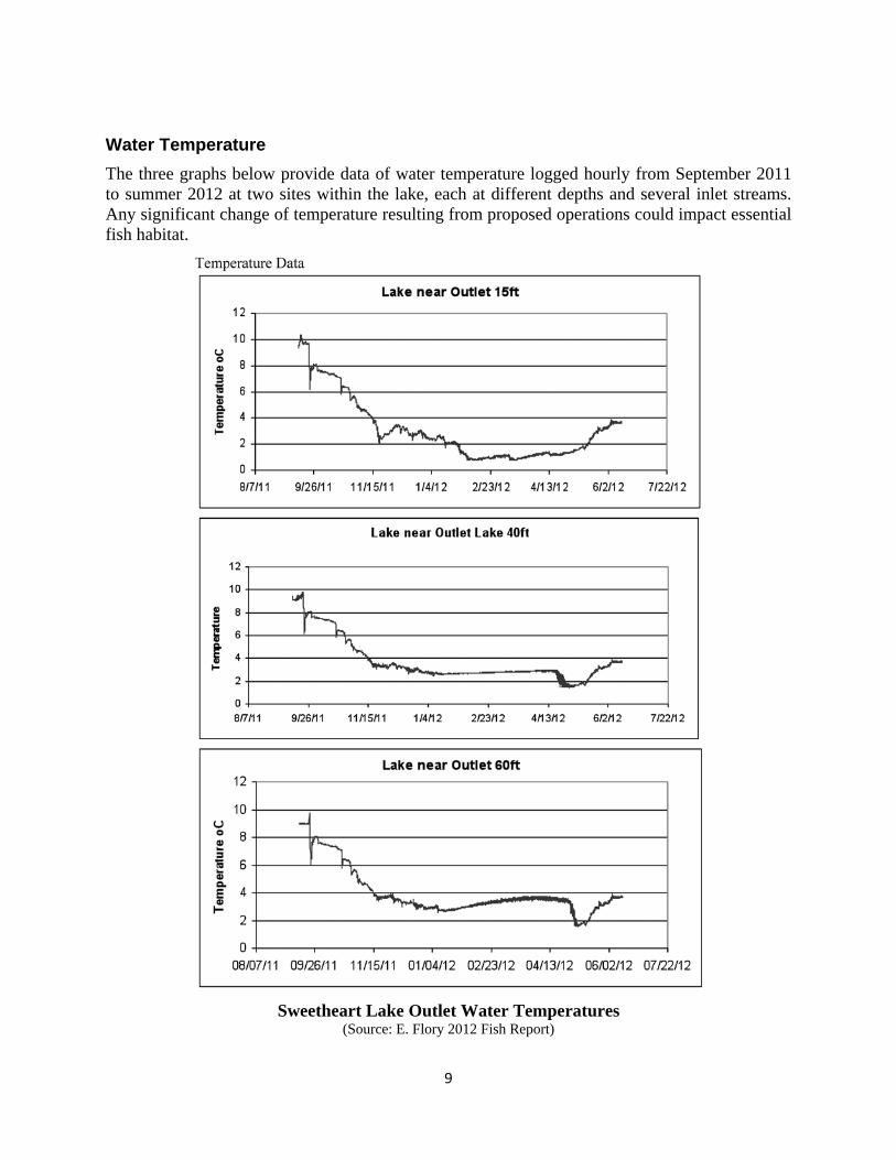
Water Temperature The three graphs below provide data of water temperature logged hourly from September 2011 to summer 2012 at two sites within the lake, each at different depths and several inlet streams. Any significant change of temperature resulting from proposed operations could impact essential fish habitat.
Sweetheart Lake Outlet Water Temperatures
(Source: E. Flory 2012 Fish Report)

10
The main lake originally had one station with loggers arrayed at 15ft, 40ft, 60ft, and 100ft, however, the loggers at 60ft and 100ft were lost. A second station near the outlet had loggers set at 15ft, 40ft, and 60ft and all were retrieved successfully for data downloading in summer 2012 and relaunched.
The station near the lake outlet showed the temperatures at all depths were similar and stable at around 7.5 – 8ºC in late September 2011 then cooling through fall. The logger at 15ft continued to fall towards 2ºC in November while deeper loggers remained above 3ºC. The 15ft logger rose back to over 3ºC in late November, and then decreased again to 1ºC in late January remaining around there until the end of March. There was then a warming period from late April through May. The deeper loggers both showed a similar dip to the coldest temperature reached on April 30 (1.4ºC at 40ft) and May 7 (1.6ºC at 60ft) perhaps around the time of surface ice melting. Unfortunately, some loggers were lost likely when ice broke out of the creeks in spring; therefore data is not available for every inlet.
At the main lake station (above the narrow pinch point) the surviving loggers at 15ft and 40ft were both similar to each other beginning at around 7.5 – 8ºC in September then falling steadily to less than 4ºC in November. Temperatures at both depths were around 3ºC in early January until a sudden dip to 0.2ºC on January 18. Temperatures were back suddenly to over 1ºC January 22 and remained steady until warming in early May. The 40ft level rose more rapidly from 2 – 4ºC during the last two weeks of May than the 15ft level, which was only 1.6ºC in the middle of May and rose to 3ºC by the end of May.
Water temperature data collected with a data logger from the base of the lower barrier falls in Sweetheart Creek is shown in graph below.
Sweetheart Creek Water Temperatures below barrier falls
(Source: E. Flory 2012 Fish Report)

11
Water Temperature at Sweetheart Gaging Stations comparisons in Centigrade (Source CSI)
Discussion The anadromous reach of Sweetheart Creek is limited by a barrier falls at 0.27 miles upriver. This distance was verified by surveys conducted in May 2012 by Max A. Schillinger of Palmer, Alaska, a registered professional land surveyor with extensive experience in coastal marine and tideland surveys. This is a limited but highly productive pink salmon habitat in a relatively small area. Therefore, limited increases in habitat improvement could yield significant benefits to the essential fish habitat. As JHI has proposed in its Draft License Application, the physical habitat for spawning, breeding, feeding or growth to maturity for anadromous natural occurring fish populations will be expanded. The increase in linear feet of the tailrace will be between 200 and 400 ft (depending on final design) and could be larger. Depending on width of 10 to 15 feet, this will yield a significant square footage increase to the overall Essential Fish Habitat of Sweetheart Creek.
-2
0
2
4
6
8
10
12
14
07/26/11 09/14/11 11/03/11 12/23/11 02/11/12 04/01/12 05/21/12 07/10/12 08/29/12 10/18/12
Wat
er Te
mpe
ratu
re, º
CSweetheart Lake Project
Water Temperature at Gaging Stations
Lower Sheetheart Lake Outlet
Sweetheart Falls Creek
12
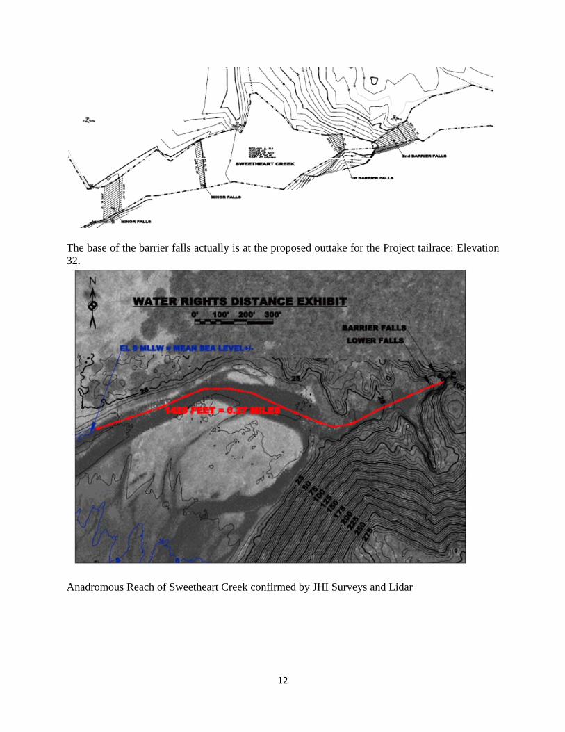
The base of the barrier falls actually is at the proposed outtake for the Project tailrace: Elevation 32.
Anadromous Reach of Sweetheart Creek confirmed by JHI Surveys and Lidar

13
Sweetheart Creek Falls February 7, 2012 92.9 cfs, 1.18 velocity fps JHI has proposed to increase the areas available for anadromous fish spawning and the spawning reach of the natural occurring pink and chum salmon by a minimum of 200 linear feet and up to 400 linear feet of engineered spawning habitat that will also act as the tailrace from the hydropower powerhouse. The tailrace will be designed and constructed to have a natural look with boulders, pools and appropriately-sized gravels. Our preliminary and final tailrace drawings are listed as a plan in Exhibit F of our draft license application. Our plan includes the use of boulders and gravel to deploy a natural tailrace that is intended to expand the pink salmon spawning habitat and therefore seeks to enhance essential fish habitat as opposed to create “adverse effects”. JHI has made an extensive investment in resources and time to install, maintain and operate two stream gages on the water system to update data that is accurate but that was collected in the early 1900’s. Further, JHI contracted with Orenco Hydropower (http://www.orencohydropower.com/) to review and synthesize the past and current hydrologic data for Sweetheart Lake. Based on the results of their detailed analysis, two alternative economic models were revealed by the data, regarding how to operate a hydropower operation on the Sweetheart Lake/Sweetheart Creek water system.
14
One alternative was to maximize the economic value of the energy that could be developed from the water system without any regard to pre-existing reservations or competing uses for the water. This alternative provided an upward bracket of what the system “could” produce to maximize power production. This alternative would not only require a larger dam, but would also essentially reverse the timing of the historic instream flows for Sweetheart Creek. In other words, the maximum energy value (as related to the demand in the Juneau market, which is winter months) would be to have large flows in the winter and less flows in the summer. This operating regime is opposite of the natural flow regime and would place stress on and possibly harm the ecosystem. Further, there would likely be water conflicts with the natural and non-native runs of salmon. Although this modeling was for “what if” evaluation purposes only, JHI as a responsible developer with responsible owners would never propose to operate any project in this manner, given the potential environmental impacts. The second alternative was to consider the ADF&G water reservation as a base condition, and then look at maximizing the value of the energy resource. The result of this analysis is the basis for our request for water rights because this alternative more nearly matches the natural flow regime in the creek, and is more likely to sustain and enhance fisheries. The “spring flow” model is the best model that we can obtain with the storage models that meets the ADF&G reservation 7 out of 12 months of the year, while also allowing the project maintain economic viability. In order to meet this alternative, the capacity of the project was significantly scaled back from an original 30 Megawatts of capacity to 19.8 Megawatts. This alternative is not without economic consequence, since electricity is more valuable during the winter, but this alternative provides a middle ground where the fishery resource is protected and can prosper while simultaneously allowing a hydropower facility to economically coexist sharing the same water source. The ADF&G water reservation request is met and surpassed by JHI’s request in 7 of the 12 months of a year in normal operating conditions as shown in the table and graph below and therefore enhances winter life cycle habitat for pink and limited numbers of chum salmon by providing additional water that increases the stream width in winter months and assists in keeping shallow and shoreline bank freezing. Moderation of the peak flows during the summer by using JHI’s flow model will potentially reduce impacts from spring/summer/fall high flows that can cause erosion of the stream bank, placing sediment in the stream; potentially covering redds.

15
The average annual base flow for Sweetheart Creek from the USGS data is 337 cfs. Our calculations, like ADFG reflect 335 cfs which is 100% QAA. JHI proposes to operate the system at 300 to 335 cfs with a turbine capacity of up to 486 cfs.
Based on scientific literature reviews, it would appear that JHI’s proposed reservation of use of water would have a neutral and arguably a positive effect on the stream habitat for salmonids and thus warrants a determination of “enhancement” and certainly not an “adverse effect” on essential fish habitat. This conclusion is based on part on the following narrative from a US Fish and Wildlife Service document
Month
ADF&G inflow request
USGS meanmonthly inflow
JHI inflow request
ADF&G compared to JHI
January 40 143 335 295February 40 71 335 295March 45 78 335 290April 119 153 335 216May 406 415 335 -71June 605 670 335 -270July 518 552 335 -183August 410 492 335 -75September 456 545 335 -121October 324 448 335 11November 117 290 335 218December 117 187 335 218
0100200300400500600700
Janu
ary
Febr
uary
M
arch
Ap
ril
May
Ju
neJu
ly
Augu
st
Sept
embe
r O
ctob
er
Nov
embe
r
Dece
mbe
r
ADF&G inflow request
JHI inflow request
USGS mean monthly inflow

16
“There is a definite relationship between the annual flow regime and the quality of salmonid riverine habitat. Adequate flows must be maintained to meet the needs of the developing embryos and yolk sac fry in the gravel, but abnormally low or high flows can be destructive. Significant mortalities to salmon embryos and yolk sac fry have been reported due to dessication or freezing of redds caused by too-low, late fall-winter flows, and from natal gravel movement and downstream displacement of newly emerged fry during abnormally high freshets (Andrew and Geen 1960). Bustard (1973) listed three major factors contributing to overwinter losses of juvenile chinook and coho salmon and steelhead in the Morice River: (1) stranding and freezing, (2) low dissolved oxygen, and (3) predation. All three factors were correlated with too-low winter flows. An annual base flow greater than or equal to 50% of the average annual daily flow is considered excellent for salmonid production, a base flow of 25% to 50% is considered fair to good, and a base flow of <25% is considered poor (adapted from Tennant 1976; Binns and Eiserman 1979; Wesche 1980). Nehring and Anderson (1982, 1983) consider a peak flow of about five times the magnitude of an excellent base flow, or about 2 times the average annual daily flow (Lister and Walker 1966) to be acceptable for good salmonid production. Peak flows exceeding these limits are considered progressively more destructive. Peak and base flow volumes that are controlled in dam tailwater salmon and trout habitats can enhance production of chum, coho, and chinook juveniles (Lister and Walker 1966) and trout (Nehring and Anderson 1982, 1983), or give a competitive edge to spring or fall spawning stocks dependent upon timing and amplitude of flow releases.” Reference: Raleigh, R.F., W.J Miller, and P.C. Nelson. 1986 Habitat suitability index models and instream flow suitability curves: chinook salmon U.S. Fish Wildl. Serv. Biol. Rep. 82(10.122). 64 pp. JHI applied Tennant’s methods to both ADF&G’s and JHI’s monthly flow quantities included in their respective applications, and using the percent of QAA figures that ADF&G used in the water reservation application. We also evaluated both sets of figures relative to the flow exceedance table (Table 1) included in ADF&G’s application. The results are in the table below. JHI provides this analysis and information to provide a scientific basis for our conclusion that our hydropower operating regime will enhance and expand the essential fish habitat of Sweetheart Creek and it’s estuarine environment.

17
In addition, JHI conducted an analysis of transects taken in the anadromous reach, with 32 data points in the areas of confirmed spawning habitat during the crest of the pink run. We found spawning velocities that fell in the 33 to 85 cm/second range, as cited by Raleigh. These data points and velocities were recorded with Sweetheart Creek running at just above 450 cfs. Based on the geography of the stream canyon Sweetheart Creek, it is likely that the velocities are lower with less cfs. JHI has velocity measurements for the last year that while not linear, confirm this trend. This reduction in velocity could reasonably improve conditions for migrating and spawning salmon at the operational level of 300 to 335 cfs.
Transect at Sweetheart Creek
Tennant (1976) modified by ADF&G (From Whitman Lake Draft S10j Submittal) Based on USGS QAA of 337
Seasonal flow descriptions
% of QAA Nov-Apr
% of QAA May-Oct
Flow using "Good" (20/40)
Flow using "Excellent" (30/50)
ADF&G flow request
USGS mean monthly flow
ADF&G flow request as % of USGS monthly
ADF&G flow request as % of"QAA"
ADF&G flow request as % of Tennant "Good"
ADF&G flow request as % of Tennant "Excellent"
JHI inflow request
QAA 100 100 Jan 67 101 40 143 28 12 59 40 335Flushing or maximum 200 200 Feb 67 101 40 71 56 12 59 40 335Optimum range 60-100 60-100 Mar 67 101 45 78 58 13 67 45 335Outstanding 40 60 Apr 67 101 119 153 78 35 177 118 335Excellent 30 50 May 135 169 406 415 98 120 301 241 335Good 20 40 Jun 135 169 605 670 90 180 449 359 335Fair or degrading 10 30 Jul 135 169 518 552 94 154 384 307 335Poor or minimum 10 10 Aug 135 169 410 492 83 122 304 243 335Severe degradation <10 <10 Sept 135 169 456 545 84 135 338 271 335
Oct 135 169 324 448 72 96 240 192 335Nov 67 101 117 290 40 35 174 116 335Dec 67 101 117 187 63 35 174 116 335

18
Based on the above guideline, JHI’s proposed use of instream flows and returning water into the tailrace between 300 and 335 cfs would provide an annual base flow greater than or equal to 50% of the average daily flow for the entire year and this is considered “excellent” for salmonid production. Our data on velocity at this transect demonstrates lower velocity at lower stream flows. The decrease in velocity during outmigration and spawning is beneficial. We also have temperature ratings for both the upper and lower gages and while there is differences, they are relatively close aligned. JHI through its proposed operations provides the following direct and indirect benefits to the essential fish habitat of Sweetheart Creek and its estuarine environment:
1. Expands salmon spawning habitat through design and installation of a “natural” tailrace with a velocity and cfs conducive to natural runs of pink and chum salmon.
2. Increases instream flows during winter periods, which is likely in turn to protect eggs and juvenile salmon from freezing, and may also decrease predation (and also prevents juvenile salmon from being canalized becoming easier prey to predators);
3. Provides an access trail (along proposed access road) to traditional salmon harvesting areas along Sweetheart Creek. The new route will decrease use of, and related habitat destruction that occurs from, the current trail that exists next to shore of Sweetheart Creek, and which is severely eroded. This road/trail infrastructure improvement will increase personal safety by decreasing bear interaction with personal use fishermen on the lower reaches of the anadromous reach;
4. Provides management control of peak and base flows which insulates against habitat destruction and thereby enhance the production of naturally-occurring salmonids;
5. Provides for long-term instream and fisheries monitoring and data collection at Sweetheart Creek for future ADF&G and NOAA/NMFS use;
6. Provides for a 3 cfs year-round release from the dam into the bypass reach, which, in combination with naturally-occurring 3% accretion flows, will help maintain aquatic resources (primary productivity, macroinvertebrates, etc.) that provide a food source for the downstream anadromous reach.
The preliminary instream flow analysis appears to show some increase in suitable spawning habitat for pink salmon. I have looked at the two main transects now including side channel sections. The lower transect crosses the side channel at its widest point (59 ft) so there seems some loss of the right velocities for spawning, but the upper transect is narrower (24ft) and habitat is increased. For transect 1 there is a change from 19 or 25% suitable habitat (depending on criteria used to define suitable spawning) to over 90% suitable at 300 cfs. For transect 2 there is a change of only 36 or 49% increasing to 42 or 61% depending on definitions used. So there is some loss at that wide part of the side channel due to velocities becoming lower than preferred, but still an overall gain in suitable habitat is gained in the main channel.

19
The net effect of JHI’s proposed operations is that high velocity currents that degrade Essential Fish Habitat are diminished resulting in better conditions and a gain in net habitat for spawning, breeding, feeding or growth to maturity of anadromous species. Additionally, the increased flows in the winter will “expand” the habitat in overwinter habitat that is essential to feeding and growth to maturity periods. Increased water flows in the winter will ameliorate the habitat and will reduce winter habitat losses that come from low water flows that increase stream bank freezing and water surface freezing at shallow areas on the lower reaches. The net impact of increased flows in the winter and decreased flows in the summer is that Essential Fish Habitat is enhanced and improved for spawning, breeding, feeding or growth to maturity species covered under the Act. Water temperature and water quality will remain unchanged with the proposed hydropower operations. The water temperature of Sweetheart lake corresponds nicely with the water in Sweetheart Creek at all seasons throughout the year. There will be no net effect on water temperature that affects the life cycle of species covered by the Act and therefore there is no adverse effect on water temperature that could impact spawning, breeding, feeding or growth to maturity of any species covered by the Act. Water quality of the lake and the stream are currently similar and the proposed hydropower operations will have no effect on water quality. The water quality from the naturally flows in the watershed and the system are unchanged. The proposed operation merely changes the amount of water and timing of the discharge into an increased fisheries habitat. There is no net effect on water quality and therefore there is no adverse effect on water quality that could impact spawning, breeding, feeding or growth to maturity of any species covered by the Act. Discussion, Recommendations and Request for a ruling of no adverse effect The crux of the issue is whether the economic use of water for a hydropower facility as proposed can coexist and perhaps enhance those waters and substrate necessary to fish for spawning, breeding, feeding or growth to maturity of naturally occurring fish of Sweetheart Creek, to fulfill the purpose and intent of the Magnuson Stevens Fishery Conservation and Management Act as Amended through January 12, 2007. Juneau Hydropower Inc. is authorized under the Alternative Licensing Process to negotiate and settle issues in writing with administrative and regulatory agencies as part of the licensing process. JHI is also the federal designee for section 7 Threatened &Endangered species. While there is no statutory requirement for JHI to be the federal designee for Magnuson Stevens Act consultation, JHI has provided this information in good faith as a step in consultation and resolution of establishing that the proposed JHI hydropower operations at Sweetheart Creek will not have an “adverse effect” on essential fish habitat, but will conversely “enhance” essential fish habitat. Based on Juneau Hydropower’s essential fish habitat investigation and analysis, the operational parameters of JHI releases of water from the natural tailrace will actually enhance and improve the "essential fish habitat" means those waters and substrate necessary to fish for spawning, breeding, feeding or growth to maturity as defined by the Act.

20
JHI appreciates your consideration, and asks that NMFS issue a finding that our proposed operations will not have an “adverse effect” on essential fish habitat. This letter is a follow up from our August 23, 2012 letter initially requesting a determination, we again ask for an agency determination of this matter. We would also like to take the opportunity to thank NMFS personnel for guidance and assistance in providing JHI consultation on our aquatic study plans. Sincerely,
Duff Mitchell VP & Business Manager