janis and natural national estate conservation requirements · janis and natural national estate...
TRANSCRIPT
JANIS and Natural NationalEstate Conservation
RequirementsA report undertaken for the NSW CRA/RFA Steering Committee


JANIS AND NATURALNATIONAL ESTATE
CONSERVATIONREQUIREMENTS
NSW NATIONAL PARKS AND WILDLIFESERVICE AND ENVIRONMENT
AUSTRALIA
A report undertaken for the NSW CRA/RFA Steering Committee
project number NE 35/EH
4 May 1998
Report Status
This report has been prepared as a working paper for the NSW CRA/RFA Steering Committee under thedirection of the Environment and Heritage Technical Committee. It is recognised that it may contain errors
that require correction but it is released to be consistent with the principle that information related to thecomprehensive regional assessment process in New South Wales will be made publicly available.
For more information and for informationon access to data contact the:Resource and Conservation Division, Department ofUrban Affairs and Planning
GPO Box 3927SYDNEY NSW 2001
Phone: (02) 9228 3166Fax: (02) 9228 4967
Forests Taskforce, Department of Prime Minister andCabinet
3-5 National CircuitBARTON ACT 2600
Phone: 1800 650 983Fax: (02) 6271 5511
© Crown copyright 4 May 1998
This project has been jointly funded by the New SouthWales and Commonwealth Governments. The workundertaken within this project has been managed by thejoint NSW / Commonwealth CRA/RFA SteeringCommittee which includes representatives from theNSW and Commonwealth Governments and stakeholdergroups.
The project has been overseen and the methodology hasbeen developed through the Environment and HeritageTechnical Committee which includes representativesfrom the NSW and Commonwealth Governments andstakeholder groups.
DisclaimerWhile every reasonable effort has been made to ensurethat this document is correct at the time of printing, theState of New South Wales, its agents and employees,and the Commonwealth of Australia, its agents andemployees, do not assume any responsibility and shallhave no liability, consequential or otherwise, of any kind,arising from the use of or reliance on any of theinformation contained in in this document.
CONTENTS
EXECUTIVE SUMMARY
1. INTRODUCTION 1
1.1 JANIS 1
1.2 NATIONAL ESTATE 2
2. CRITERIA 3
2.1 JANIS CRITERIA 32.1.1 Forest ecosystems 32.1.2 Species 32.1.3 Old growth 42.1.4 Wilderness 4
2.2 NATIONAL ESTATE VALUES 4Category 1 National Estate values 4Category 2 National Estate values 5Category 3 National Estate values 5
3. METHODOLOGY 7
3.1 BACKGROUND 7
3.2 FOREST ECOSYSTEMS 73.2.1 Rule set for obtaining JANISconservation requirements for forestecosystems 73.2.2 Changes to the rule set 8
3.3 SPECIES 83.3.1 Fauna 83.3.2 Flora 9
3.4 OLD GROWTH 103.4.1 Background 103.4.2 Obtaining conservation requirements 103.4.3 Target setting and conservationrequirements 11
3.5 WILDERNESS 113.5.1 Background 113.5.2 Target setting 12
3.6 NATIONAL ESTATE 123.6.1 Background 123.6.2 Identifying indicative areas of NationalEstate significance 12
4. RESULTS 15
4.1 FOREST ECOSYSTEMS 15
4.2 SPECIES 154.2.1 Fauna 154.2.2 Flora 16
4.3 OLD GROWTH 164.3.1 Recommendations for determiningconservation requirements in future CRAs 16
4.4 WILDERNESS 174.4.1 Negotiations considerations 17
4.5 NATIONAL ESTATE 174.5.1 Old growth forests 174.5.2 Wilderness 184.5.3 Principal characteristics of vegetationclass 184.5.4 Rare, vulnerable or endangered species 184.5.5 Centres of endemism 184.5.6 Refugia 194.5.7 Relictual species 204.5.8 Disjunct species 204.5.9 Flora community diversity or richness 20
5. CONCLUSION 34
6. REFERENCES 36
7. APPENDICES 38APPENDIX 3.1 - Supporting documentationfor forest ecosystems target table 38APPENDIX 3.2 Expert panelrecommendations 41APPENDIX 3.2(B) Old growth forestconservation options - Eden region, NSW 45APPENDIX 3.3 - Supporting documentationfor the old growth target table 48APPENDIX 4.1 Target table for forestecosystems in the Eden CRA area 50APPENDIX 4. 2 - Minutes of the forestecosystem workshop on target setting forconservation requirements 55APPENDIX 4.3: Details of maps created forspecies with area targets 59APPENDIX 4.4: A Summary of the finalagreed target areas and associatedinformation. 64APPENDIX 4.5 - Habitat models andsub-region maps 66APPENDIX 4.6 - Flora species target table123APPENDIX 4.7 Old growth target tables 128APPENDIX 4.8 - Endemic flora species 132APPENDIX 4.9 - Disjunct flora speciesfor Eden CRA 133APPENDIX 4.10 - National Estateassessment workshop report 134APPENDIX 4.11 - Australian heritagecommission criteria for the register of theNational Estate 148
TABLESTABLE 1: Extent of NWI high qualitywilderness in dedicated reserves 17TABLE 2: Extent of NWI high qualitywilderness on different land tenures 17
TABLE 3: Land tenure of the area assessedas significant for flora communities 18TABLE 4: Land tenure of the area assessedas centres of floristic endemism 18TABLE 5: Types of areas delineated asrefugia 19TABLE 6: Land tenure of the area assessedas significant as refugia 20TABLE 7: Land tenure of the area assessedas significant for relictual species 20TABLE 8: Land tenure of the area assessedas important for species with disjunctpopulations 20TABLE 9: Land tenure of the area assessedas having high diversity or richness 20
MAPSMAP 1: Indicative areas significant forflora communities (NationalEstate criterion D1) 21MAP 2: Indicative areas significant ascentres of floristic endemism (NationalEstate criterion A.1) 23MAP 3: Indicative areas significant asrefugia (National Estate criterion A.2) 25MAP 4: Indicative areas significant forrelictual, primitive and/or Gondwanicspecies (National Estate criterion A.1) 27MAP 5: Indicative areas significant forspecies with disjunct populations(National Estate Criterion A.1) 29MAP 6: Indicative areas significant forvegetation diversity or richness (NationalEstate criterion A.3) 31

EXECUTIVE SUMMARY
This report has been prepared for the jointCommonwealth/State CRA/RFA SteeringCommittee, which oversees the comprehensiveregional assessments (CRAs) of forests in NewSouth Wales.
The CRAs provide the scientific basis on which theState and Commonwealth governments will signregional forest agreements (RFAs) for the majorforests of New South Wales. These agreementswill determine the future of the State’s forests,providing a balance between conservation andecologically sustainable use of forest resources.
This report was undertaken to document theestablishment of conservation requirements for allthe elements of biodiversity (including forestecosystems, fauna and flora species, old growthand wilderness) considered in the Eden CRA.NSW NPWS in consultation with EnvironmentAustralia (EA) and State Forests of New SouthWales (SFNSW) developed a process that enabledthe formulation of these conservation requirements.
An assessment of national estate values has alsobeen undertaken as part of the CRA process. Thisreport describes how natural national estate valueshave been derived in this project. It identifies datalayers and areas of potential national estate value;though these identify indicative areas. Theattributes and indicative areas will be taken intoaccount in compiling and delineating national estateplaces for endorsement by the Australian HeritageCommission and, after standard statutoryrequirements, entry onto the Register of theNational Estate.
Rule sets were applied to data layers derivedduring previous CRA projects. Habitat protectiontargets for forest ecosystems, species, old growthand wilderness were produced. Expert panelsreviewed these protection targets and provided
relative rankings for vulnerability to threateningprocesses and suggestions to aid the bestexpression of targets during negotiations. Targettables and vulnerability rankings were produced foreach element of biodiversity. Areas of nationalestate significance, in terms of centres ofendemism, refugia, relictual species, and highdiversity or richness, were described.
Results are presented in a series of tables anddiscussion papers attached in the appendices.Protection targets were produced in a formatcompatible with C-Plan, the software package usedto assess the resource, heritage and biodiversityvalues of land in the Eden CRA region. Targetswere integrated with other data layers within C-Plan so that strategies for achieving the bestconservation outcomes could be devised.

1
1. INTRODUCTION
1.1 JANIS
The conservation requirements project was thefinal project to be undertaken for the biodiversityassessments in the Eden CRA region. TheEnvironment and Heritage Technical Committeerequested NPWS, in consultation with EnvironmentAustralia (EA) and State Forests of New SouthWales (SFNSW), to develop a process that wouldenable the formulation of conservationrequirements for all elements of biodiversity underconsideration.
The primary aim of the project was to derive theJANIS conservation requirements for the elementsof biodiversity considered in the Eden CRA region,such as forest ecosystems, species (flora andfauna), old growth and wilderness. A secondaryaim of this project was to ensure natural NationalEstate assessments were undertaken, with anefficient use of resources, and that these wereincluded where practicable to add value indetermining conservation requirements.
Conservation requirements were derived accordingto the JANIS criteria for forest biodiversity, oldgrowth and wilderness (JANIS 1997). Theresultant outputs were checked against the relevantNational Estate and other criteria in the NSWScoping Agreement to ensure that these criteriawere also met. National Estate values, which haveJANIS equivalents but no specific reservationtargets, were derived and assessed against theNational Estate criteria. These included areas ofhigh biodiversity, refugia, relicts, centres ofendemism, disjunct species and species poorlycorrelated with forest ecosystems.
The conservation requirements project determinedthe amount and spatial configuration, of eachelement of biodiversity, that needed to be identifiedfor the Eden CRA, ensuring that the appropriate
habitat protection targets were defined forintegration. The JANIS and National Estate criteriaformed the basis for determining the habitatprotection targets. Where JANIS and the NationalEstate overlapped, the National Estate assessmentswere based on identifying the best expression,based on regionally determined thresholds, of theJANIS values.
It was recognised early in the process that theestablishment of habitat protection targets forforest ecosystems, old growth and wildernesswould involve a relatively straight forwardtranslation of the JANIS reserve criteria to therelevant data layers, subject to alterationsdetermined by expert panels and the Environmentand Heritage Technical Committee which overseesenvironment and heritage assessments in the NSWCRA process. However, details for species wereless well defined in JANIS, so the formulation ofhabitat protection targets for species of flora andfauna became the responsibility of another project(Response to Disturbance) in consultation withNPWS and SFNSW.
Expert panels were used to review protectiontargets and to make suggestions for conservationoutcomes. All conservation targets produced duringthis project were integrated within the C-Planmatrix, which enabled the formulation of strategiesfor negotiations.
The conservation requirements project wasdependent on all the data layers derived from theEden CRA. The area being assessed included allthe forested public and private lands in the EdenCRA region. The Eden methodology wasdeveloped in a very short time frame and may notnecessarily form the basis for or be similar to, theformulation of requirements for other CRA regionsin NSW.
JANIS and Natural National Estate Conservation Requirements
2
1.2 NATIONAL ESTATE
The National Estate is defined in the AustralianHeritage Commission Act 1975 as:
“... those places, being components of the naturalenvironment of Australia, or the cultural environmentof Australia, that have aesthetic, historic, scientific orsocial significance or other special value for futuregenerations as well as for the present community.”
The Australian Heritage Commission’sresponsibility is to identify the National Estate and,under section 30 of the Act, to advise theCommonwealth Government on the conservation ofnational estate places and the potential impact onnational estate values of proposals relating to thoseplaces. The Act also requires the establishment ofthe Register of the National Estate. The Registerincludes places of importance at a local, regional,State or national level. The identification andassessment of places for inclusion on the Registeris guided by the national estate criteria (seeAppendix 4.11).
In the regional context, identification of theNational Estate requires a comparative assessmentof the significance of places having one or moreNational Estate value or attributes as identified bythe criteria. This requires developing an appropriateregional context, identification of national estatevalues, and establishing a ‘threshold’ ofsignificance to identify areas of ‘significant value’.
This report identifies data layers and areas ofpotential significant national estate value, thoughthese are indicative areas only. The attributes andindicative areas will be taken into account incompiling and delineating national estate places forendorsement by the Australian HeritageCommission and, after standard statutoryrequirements, entry onto the Register of theNational Estate.
Under the National Forest Policy Statement (NFPS1992) Commonwealth, State and TerritoryGovernments also agreed to the assessment ofNational Estate values of forests. Attachment 1 ofthe NSW CRA/RFA Scoping Agreement requiresthe CRAs to “identify, assess and documentnational estate values including natural and culturalheritage in NSW to satisfy Commonwealthobligations under the Australian HeritageCommission Act 1975.”
Key points from the Scoping Agreement include:
n Identification to be undertaken jointly by theAustralian Heritage Commission (theCommission) and NSW in accordance withnational estate criteria for identifying places ofsignificance;
n Values identified and methodologies utilised tobe jointly agreed between the Commission andNSW government;
n Identification, delineation and mapping ofnational estate values and places;
n Assessment of current levels of protection ofnational estate values and places;
n Identification of conservation principles for theprotection of national estate values and places;
n Documentation of agreed methodologies; and
n Documentation sufficient for interim listing inthe Register of the National Estate (RNE)where appropriate.
3
2.CRITERIA
2.1 JANIS CRITERIA
The JANIS report, Nationally Agreed Criteriafor the Establishment of a Comprehensive,Adequate and Representative Reserve Systemfor Forests in Australia (1997), provides thenational criteria for the conservation of forestbiodiversity, old growth forests and wilderness.These criteria form the foundation for conservingall elements of biodiversity, old growth andwilderness under consideration in the Eden CRA.The relevant JANIS criteria are summarised asfollows:
2.1.1 Forest ecosystems
JANIS reference: 6.1.2
(1) As a general criterion, 15% of the pre-1750distribution of each forest ecosystem should beprotected in the CAR reserve system withflexibility considerations applied according to theregional circumstances, and recognising that as faras possible and practicable, the proportion ofdedicated reserves should be maximised.
(2) Where forest ecosystems are recognised asvulnerable, then at least 60% of their remainingextent should be reserved. A vulnerable forestecosystem is one, which is:
n approaching a reduction in areal extent of 70%within a bioregional context and which remainssubject to threatening processes; or
n not depleted but subject to continuing andsignificant threatening processes which mayreduce its extent.
(3) All remaining occurrences of rare andendangered forest ecosystems should be reservedor protected by other means as far as practicable.
(4) Reserves should be replicated across thegeographic range of the forest ecosystem todecrease the likelihood that chance event such as
wildfire or disease will cause the forest ecosystemto decline.
2.1.2 Species
JANIS reference: 2.1 The objectives of biodiversityconservation for forests:
n to maintain viable populations of native forestspecies throughout their natural ranges, and
n to maintain genetic diversity of native forestspecies.
JANIS reference: 6.1.2
(5) The reserve system should seek to maximisethe area of high quality habitat for all knownelements of biodiversity wherever practicable, butwith particular reference to:
n the special needs of rare, vulnerable orendangered species,
n special groups of organisms, for examplespecies with complex habitat requirements, ormigratory or mobile species,
n areas of high species diversity, natural refugiafor flora and fauna and centres of endemismand,
n those forest species whose distribution andhabitat requirements are poorly correlated withforest ecosystems.
(6) Reserves should be large enough to sustain theviability, quality and integrity of populations.
For the Eden CRA, the species criteria have beenaddressed primarily by the Response toDisturbance project. However, areas such as highspecies diversity, natural refugia for flora andfauna, centres of endemism, and those forestspecies whose distribution and habitat requirementsare poorly correlated with forest ecosystems willbe dealt with by the national estate criteria.
JANIS and Natural National Estate Conservation Requirements
4
2.1.3 Old growth
JANIS reference: 6.2.2
(1) Where old growth forest is rare or depleted(generally less than 10% of the extant distribution)within a forest ecosystem, all viable examplesshould be protected, wherever possible. In practice,this would mean that most of the rare or depletedold growth forest would be protected. Protectionshould be afforded through the range ofmechanisms described in section 4.
(2) For other forest ecosystems, 60% of the oldgrowth forest identified at the time of assessmentwould be protected, consistent with the flexibilityapproach where appropriate, increasing to thelevels of protection necessary to achieve thefollowing objectives:
n the representation of old growth forest acrossthe geographic range of the forest ecosystem,
n the protection of high quality habitat for speciesidentified under the biodiversity criterion,
n appropriate reserve design,
n protection of the largest and least fragmentedareas of old growth, and
n specific community needs for recreation andtourism.
2.1.4 Wilderness
JANIS reference: 6.3.1
Ninety percent or more if practicable, of the areaof high quality wilderness that meets the minimumarea requirements should be protected in reserves.
(1) Potential wilderness areas will need to:
n have a minimum NWI rating of 12. In addition,minimum thresholds for each of the wildernessquality indicators will be set within the regionalcontext. This threshold will take into account theimportance of the indicators, and in particularthe biophysical naturalness component as aprimary indicator.
n The guideline for size that is consideredgenerally appropriate for areas encompassingforested wilderness is 8,000 hectares. However,a threshold of less than 8,000 hectares mayapply to areas contiguous with the sea or whichadjoin wilderness areas in adjacent regions.Higher thresholds may apply within a regionwhere wilderness is extensive.
n The presence of potential areas of nodal areaswithin higher wilderness quality may provide anindication of their significance and may guidethe future management of identified wildernessareas.
n Other factors that are not considered indetermining the NWI rating may need to beconsidered, in determining wilderness quality.These factors may include the impacts of exoticplants and feral animals on biophysicalnaturalness.
(2) Determining wilderness boundaries:
n Potential areas identified using the NWIdatabase will be considered in a regional contextto ensure their viability as wilderness, includingconsiderations of shape.
n Both ecological and management features suchas topography, water catchment boundaries,roads and other transport routes, may be usefulwhen delineating boundaries.
2.2 NATIONAL ESTATE VALUES
The identification and assessment of places forinclusion on the Register of the National Estate isguided by the national estate criteria (see Appendix4.11).
The JANIS criteria did not set targets forreservation of the National Estate but establishedthe objective of maximising protection of theNational Estate in the reserve system. Nationalestate assessments introduce a quality componentinto the achievement of the JANIS targets. In thisway integration is more likely to select the 'best’15% or the 'best’ 60% of a particular JANIS valueto meet targets.
For the purposes of the CRA/RFA process thenational estate criteria and the assessment ofnational estate values was divided into three broadcategories, based on their degree ofcorrespondence with the JANIS criteria andassessments. These are:
Category 1 National Estate values
Where there is a direct correspondence betweennational estate values and JANIS criteria with aspecific JANIS target, the JANIS assessmentprovided the primary data layer from which the
JANIS and Natural National Estate Conservation Requirements
5
national estate values were identified. This wasthe case for:
n Old growth forests(A.2 Continuing processes)
n Old growth forests by alliance or community (B.1 Natural rarity)
n Wilderness(B.1 Natural rarity)
n Principal characteristics of vegetation class(D.1 Principal characteristics of class)
n Rare flora communities(B.1 Natural rarity)
Category 2 National Estate values
Where there is a direct correspondence betweennational estate values and JANIS criteria and nospecific JANIS target, the national estateassessment identified the areas of significant value.These significant areas were then considered ashaving high conservation value under the relevantJANIS criteria. This was the case for:
n Flora and fauna refugia(A.1 Past processes, A.2 Continuing processes)
n Flora and fauna species - relictual and/orGondwanic species(A.1 Past processes)
n Flora and fauna species endemic to region(A.1 Past processes)
n Flora and fauna species - disjunct populations(A.1 Past processes)
n Flora and fauna species at edge of natural range(A.1 Past processes)
n Flora and fauna species richness(A.3 Richness and diversity)
n Migratory fauna species (RAMSAR, CAMBA,JAMBA sites and others)(A.2 Continuing processes)
n Rare flora and fauna species and their habitats(B.1 processes)
Category 3 National Estate values
Where there are no JANIS criteria that correspondwith the national estate value.
n Undisturbed catchments(A.2 Continuing processes)
n Flora communities diversity(A.3 Richness and diversity)
n Areas of unusual habitat richness(A.3 Richness and diversity)
n Natural landscapes(B.1 Natural rarity)
n Wetlands(B.1 Natural rarity & D.1 Principalcharacteristics of class)
n Fauna species - disjunct populations(A.1 Past processes)
n Remnant vegetation(A.2 Continuing processes)
n Important wildlife habitats(A.2 Continuing processes)
n Vegetation succession(A.2 Continuing processes)
n Flora species richness(A.3 Richness and diversity)
n Geological and geomorphological values(A.3 Richness and diversity, B.1 Natural rarity,D.1 Principal characteristics of class)
n Natural research, reference and teaching sites(C.1Natural research, references, teachingsites)
Assessments relating to a number of these criteriawere not undertaken directly in the Eden CRAprocess, but were incorporated as part of otherprojects. These are listed below with anexplanation as to how they were considered:
n Wetlands - All wetlands were identified as partof the Forest Ecosystem project and wereincluded in the national estate refugia analysis.
n Flora species at edge of natural range - Expertopinion was that a specific assessment of thisvalue in the Eden region would be very difficultas many species reach the southern or northernlimit of their natural range in the Eden region.
n Fauna species endemic to region - According toexpert opinion, there are no vertebrate speciesendemic to the Eden region. However furthertaxonomic work may alter this opinion.
n Migratory fauna species (RAMSAR, CAMBA,JAMBA sites and others) - No RAMSAR sites,or sites significant for CAMBA or JAMBA
JANIS and Natural National Estate Conservation Requirements
6
species are known to occur in forested areas inEden region.
n Fauna species - disjunct populations - Priorityfauna species with disjunct populations wereidentified and considered in the Response to theDisturbance project (Environment Australia1997).
n Remnant vegetation - Remnants of rare or oldgrowth vegetation types were identified inJANIS assessments.
n Important wildlife habitats - Important areas ofwildlife habitat would include old growth forest,refugia, wetlands, areas of high plant diversity,rainforest and riparian areas. These were allidentified in other JANIS or national estateassessments.
n Areas of unusual habitat richness - Areas ofhigh vegetation diversity and/or richness couldbe considered as a surrogate for identifyingareas of unusual habitat richness.
Assessments relating to the following criteria werenot able to be undertaken in the Eden CRA processdue to the limited time available:
n Vegetation succession
n Faunal species richness
n Flora species richness
n Fauna species at edge of natural range
State-wide projects have been initiated for theidentification and assessment of geological andgeomorphological values, and natural research,reference and teaching sites. The results of theseprojects are not available in time for the EdenCRA/RFA.

7
3.METHODOLOGY
3.1 BACKGROUND
Conservation requirements, for the Eden CRAregion, were derived in the following way:
For those JANIS values where there were specificreservation targets, explicit decision rules wereformulated on the basis of the rules defined in theJANIS criteria. For those JANIS values wherethere were not specific reservation targets, explicitdecision rules would be formulated on the basis ofexpert advice. The resulting rule sets are describedin the sections below. Using these rule sets, habitatprotection targets for each entity were calculatedand each was ranked according to its relativevulnerability. Vulnerability rankings were used toformulate procedures in integration. The agreedrule sets and analytical techniques were thenapplied to the derived data layers to providereservation targets for each entity. Provisional ruleswere developed to guide the expert panels on howto effectively apportion overall targets across thelandscape with full consideration of patch size,internal variation and appropriate protectionmechanisms.
Expert panels reviewed the derived targets andsuggested best expressions of the values, i.e. areasof national estate significance. These conservationtargets were then applied to the final data layersprior to integration.
All datasets and conservation requirements werecompatible with the C-Plan software in preparationfor integration. Additional information was suppliedby expert panels to ensure that protection targetswould be sought effectively across the landscapewithin differing levels of reservation.
Stakeholders were involved in the endorsement ofthe process for target setting and actual targets.They were also involved in the selection of expertsto assist in target setting.
3.2 FOREST ECOSYSTEMS
3.2.1 Rule set for obtaining JANISconservation requirements for forestecosystems
The process for formulating levels of reservationfor forest ecosystems was based on the relevantJANIS criteria outlined in section 2.1.1.
Vulnerable ecosystems include those wherethreatening processes have caused significantchanges in species composition, loss or significantdecline in species that play a major role within theecosystem, or significant alteration to ecosystemprocesses.
A rare ecosystem is one where its geographicdistribution involves a total range generally lessthan 10,000 hectares, a total area of generally lessthan 1000 hectares or patch sizes of generally lessthan 100 hectares, where such patches do notaggregate to form significant areas.
An endangered ecosystem is one where itsdistribution has contracted to less than 10% of itsformer range or the total area has contracted toless than 10% of its former area, or where 90% ofits area is in small patches which are subject tothreatening processes and unlikely to persist.Where forest ecosystems are recognised as rare orendangered, then 100% of their remaining extentshould be targeted for reservation.
In terms of rare, vulnerable and endangeredecosystems it is recognised that a range ofapproaches varying from reservation to prescriptionmanagement will be needed to ensure thepersistence of forest ecosystems.
Each forest ecosystem was ranked according to itsrelative vulnerability to threatening processes (suchas inappropriate fire regimes, logging, clearing,weeds, disease, etc) and the likelihood of thesethreats occurring. In the first instance these
JANIS and Natural National Estate Conservation Requirements
8
rankings would be used to adjust reservationtargets where appropriate and secondly to guidefall back options during negotiations such that mostthreatened forest ecosystems receive reservationprimacy in dedicated reserves and the leastthreatened receive greater levels of informalreservation and or prescriptive management wherethis is judged desirable.
Other JANIS criteria to be taken into accountwere:
n To ensure representativeness, the reservesystem should, as far as possible, sample the fullrange of biological variation within each forestecosystem, by sampling the range of variationtypical of its geographic range and sampling itsrange of successional stages. Forestecosystems are often distributed across avariety of physical environments, and theirspecies composition can vary alongenvironmental gradients and between themicroenvironments within the ecosystem. Thisapproach will maximise the likelihood that thesamples included in the reserve system willprotect the full range of genetic variability andsuccessional stages associated with eachspecies, and particularly those species withrestricted or disjunct distributions.
n In fragmented landscapes, remnants thatcontribute to sampling the full range ofbiodiversity are vital parts of a forestecosystem. These areas should be identified andprotected as part of the development ofintegrated regional conservation strategies.
n Areas of national estate significance withineach forest ecosystem will be highlighted.
An expert panel made up of Doug Binns (SF),David Keith (NPWS), Phil Gilmore (Independent)and Karl Bossard (EA) reviewed the rule set andresulting targets. It was the responsibility of thisexpert panel to award vulnerability rankings to eachforest ecosystem and highlight managementconsiderations relevant to negotiations.
Appendix 3.1 contains a description of the targettable derived from the application of the rule setand results from the expert panel workshop.Appendix 4.2 details the proceedings of the expertpanel workshop.
3.2.2 Changes to the rule set
Prior to negotiations the Environment and HeritageTechnical Committee decided that vulnerabilityrankings would not be used to adjust conservationtargets for forest ecosystems. It was felt that if thetargets were increased due to their highervulnerability to threatening processes, then forestecosystems with low vulnerability should have theirtargets adjusted down. This was not acceptable toall members of the committee and therefore it wasresolved by the Steering Committee to adjusttargets by vulnerability rankings only where threatsare precluded by tenure over less than 30% of thepre-1750 extent.
3.3 SPECIES
Conservation requirements for flora and faunaspecies of significance (based on JANIS criteria)followed on from the Response to Disturbance(RTD) project for the Eden CRA. Results obtainedduring the response to disturbance project wereused in the target setting and ranking ofvulnerability to threatening processes.
Two tasks were undertaken to determineconservation requirements for significant species inthe Eden CRAs:
n finalisation of species targets and preparation ofdata for C-Plan,
n finalisation of species reservation requirementor vulnerability rankings (see also the Responseto Disturbance report).
3.3.1 Fauna
Species targets
JANIS principles relating to species are detailed insection 2.1.2. The following steps for settingpriority fauna species conservation wereundertaken as part of the Response to Disturbanceproject.
n Fauna habitat models and definitions for core,intermediate and marginal habitat quality werereviewed and altered as required. Where therewas no appropriate model, a) a surrogate modelwas built using vegetation and other information,b) buffer zones were applied to point locationsor c) management recommendations only were
JANIS and Natural National Estate Conservation Requirements
9
specified to ensure appropriate conservation ofthe species.
n The carrying capacity of core, intermediate andmarginal quality habitat for each species wasset.
n A single habitat protection target area wasselected from the range of values (see theResponse to Disturbance report). A minimumpatch size area for each species was alsodefined.
n The habitat protection targets were appliedspatially by drawing areas (sub-regions) onmaps of the fauna habitat models to guide theallocation of the minimum patch size areas ofprotection across the Eden CRA region. Thistask included specifying the number of patches,minimum patch size and dispersal distanceinformation. Digital layers such as vegetationcommunities, forest growth stage, logginghistory and point locations assisted in thisprocess. (Only one spatial configuration wasdrawn per species, one that aimed for optimalhabitat protection).
n Brief management recommendations wereformulated and additional habitat protectiondesign information was recorded for eachspecies.
Reservation requirement ranks
Species were ranked on their relative need for theprotection target to be met by dedicated reservationas opposed to informal reservation or prescription.The ranking was designed to ensure that dedicatedreservation would be applied to those entities thatrequire it most. See the Response to Disturbanceproject report for details.
3.3.2 Flora
Species targets
Species targets refer to populations of priority floraspecies and were determined by an expert panel(made up of Doug Binns and Ross Peacock fromState Forests of NSW, Michael Doherty fromCSIRO, David Keith from NSW National Parksand Wildlife Service, and Phil Gilmour as anindependent consultant). The following rule setswere used when determining targets for significantflora species in the Eden CRA:
n A minimum target of five populations wasagreed to by the expert panel;
n Those species which were considered to beat a higher risk of extinction were identifiedand their targets were adjusted upwards toten populations based on the following sixrules for adjusting global minimum targets:
1) short-lived seed bank;
2) requires undisturbed habitat for recruitment;
3) no known mechanism for recovery afterdisturbance;
4) small area of occupancy (local populations)and susceptibility to soil disturbance;
5) habitat restricted to fragmented areas andsusceptible to habitat loss; and
6) highly restricted distribution (<10km).
n For species that qualified for the aboveadjustment, and had fewer than ten knownpopulations, the number of known populationswere targeted; and
n There were some exceptions to the abovecriteria and these species were not adjustedeven though they met one of the above and aredocumented in the Response to Disturbanceflora workshop report compiled by EnvironmentAustralia.
In order to determine the number of populations ofsignificant flora species occurring in the Eden studyarea, the following process was used. (This did notalter targets set by experts, but just determinedhow many populations were in reserves and howmany were outside the reserve system):
n A database of verified flora species locationswas created and reviewed by the expert panel.Old records with poor spatial precision wereexcluded;
n This database was used to create a GIS layershowing species presence/absence by tenure;
n From this layer a report was generated showingspecies occurrence within planning units.Species presence within a planning unit wasdefined as one population, regardless of thenumber of individuals;
n Two adjustments to targets were necessarybefore data were loaded into C-Plan. Where thetotal number of ‘populations’ exceeded the
JANIS and Natural National Estate Conservation Requirements
10
conservation target, the target was adjusted tothe total number. Second, the number ofpopulations within reserves was subtracted fromthe adjusted target to give a ‘residual’population target outside reserves.
3.4 OLD GROWTH
3.4.1 Background
The following criterion are defined within JANIS(1997) to ensure appropriate reservation of oldgrowth forest:
1) Where old-growth forest is rare ordepleted (generally less than 10% of theextant distribution) within a forestecosystem, all viable examples should beprotected, wherever possible; and
2) Where old growth forest is greater than10% of the extant distribution within aforest ecosystem, 60% of the old-growthforest identified at the time of assessmentshould be protected with a flexibleapproach where appropriate, increasing tothe levels of protection necessary toachieve the following objectives:
n assess the representation of old growthforest across the geographic range of theforest ecosystem;
n the protection of high quality habitat forspecies identified under the biodiversitycriterion;
n appropriate reserve design;
n protection of the largest and leastfragmented areas of old growth; and
n specific community needs for recreation andtourism.
3.4.2 Obtaining conservationrequirements
Prior to the meeting of the expert panel on oldgrowth the following criteria were outlined in orderto achieve the conservation requirements for oldgrowth, as recommended in JANIS, for the EdenCRA:
n obtain provisional old growth targets bycalculating the extent of forest as a % of eachforest ecosystem.
n assess whether old growth forest is rare ordepleted;
n identify largest and least fragmented areas ofold growth;
n determine representation of old growth forestacross the geographic range of each forestecosystem;
n adjust target after consideration offragmentation and landscape disturbance;
n identify High Quality Habitat old growth forest;
n identify aesthetic and cultural values of oldgrowth areas;
n determine minimum viable patch size;
n select other ‘growth stages’ when forestecosystem target exceeds old growth target;
n rank old growth forest types in terms of theirsensitivity to threatening processes; and
n incorporate spatial considerations into targetselection.
The expert panel, made up of Bob Bridges(SFNSW), Paul O’Connor (NPWS), Tony Norton(Independent), Sara May (EA), and Jane Coram(AGSO), decided upon the following changes to thecriteria in order to best achieve the conservationtargets in the limited time available:
n fragmentation and contiguity analysis of oldgrowth forest not possible for Eden CRA;
n adjustment of targets for landscape disturbancebased on a sliding scale; and
n acceptance of forest ecosystem rankings forvulnerability to threatening processes.
Appendix 3.2 (a) and (b) provides details of theexpert panel’s suggestions.
After the meeting of the expert panel the criteriawere reviewed by the Environment and HeritageTechnical Committee and the landscapedisturbance adjustment, recommended by theexpert panel was accepted. The nominatedapproach to deriving high quality habitat old growthwas also accepted. (i.e. High Quality Habitat OldGrowth (HQHOG) defined as the union of all corefauna species models intersected with candidateold growth). The Environment and HeritageTechnical Committee did not accept the translationof forest ecosystem vulnerabilities to old growthand a special meeting was called to discuss this
JANIS and Natural National Estate Conservation Requirements
11
issue. The following change was made in responseto the this meeting:
n sensitivity or vulnerability to disturbance rankingbe determined using proportions of old growtharea in 1997 relative to the sum of young andrecently disturbed forest for each forestecosystem;
Changes to the derivation of HQHOG as explainedabove were made prior to reference pointdevelopment as it became clear that the aboveapproach was not achieving its aim of preferentiallyselecting the core patches of old growth. Analternative approach that attempted to defineHQHOG as old growth habitat where species findoptimal habitat for foraging or nesting was thenattempted with a list of species reviewed byEnvironment and Heritage Technical Committeemembers. Although there were dissenting viewsabout individual species the union of the corehabitat of the following list of species intersectedwith candidate old growth was agreed to byEnvironment and Heritage Technical Committeeand used to define HQHOG for:
n Tiger Quoll
n Powerful Owl
n Sooty Owl
n Greater Glider
n Yellow-bellied Glider
n Stuttering - Barred Frog
The Joint RFA / CRA Steering Committeerequested that old growth targets not be adjustedfor landscape disturbance and revert to theprovisional old growth target split according to theJANIS criteria 1 & 2 i.e. 100% or 60%. Thischange was implemented except for adjustment ofindividual old growth types with a 60% target thathad been identified as being rare or highly depleted.These types were allocated a 100% target.
3.4.3 Target setting and conservationrequirements
Appendix 3.3 contains a description of the targettable for old growth forests.
3.5 WILDERNESS
3.5.1 Background
JANIS details a specific target for wilderness (seesection 2.1.4). It states that “90% or more ifpracticable of the area of high quality wildernessthat meet minimum area requirements should beprotected in reserves”. It further suggests meansfor determining potential wilderness areas and fordetermining potential wilderness boundaries.
For the purpose of the RFA, and National Estateassessment, the JANIS criteria defined theidentification of ‘high quality wilderness’. Thisinvolved using an up-to-date National WildernessInventory (NWI) to identify areas of at least 8,000hectares of NWI Wilderness Quality 12 or above.The Environmental Heritage and TechnicalCommittee determined that the NWI needed torecognise national manageable boundaries.
The following set of rules was adhered to indelineating wilderness boundaries:
n wilderness areas should preferably have a lowperimeter-to-area ratio;
n wherever possible boundaries should includecomplete catchments and the entirety ofdistinctive topographic features such as massifs,plateaux, gorges and escarpments;
n where the use of natural features isinappropriate, boundaries should follow featuresor infrastructure which are clearly identifiable‘on the ground’, such as roads, transmissionlines, fence lines, or native vegetation/clearedland interfaces;
n boundaries should be set to include bufferswherever possible to protect high qualitywilderness from future disturbances on adjacentland;
n boundaries should be set at a minimal distance(20 metres) from bordering roads and otherdisturbed sites;
n relatively small disturbed areas which arecapable of being restored may be includedwithin a delineated wilderness if to do so would:
− enhance the wilderness quality of thesurrounding or adjacent wilderness; or
− result in the amalgamation of otherwiseseparate nodes of high quality wilderness;
JANIS and Natural National Estate Conservation Requirements
12
n boundaries associated with impoundmentsshould follow the high water mark; and
n the use of point-to-point straight lines or contourlines that are not apparent ‘on the ground’should be avoided wherever possible.
Although the delineation process aimed to captureall land of high quality wilderness within wildernessboundaries, in some instances small areas wereexcluded due to shape and viability considerations.Conversely, in other places, small areas ofrelatively low wilderness quality were incorporatedwithin boundaries for practical managementreasons.
3.5.2 Target setting
The report on the wilderness assessment project,carried out as part of the Eden CRA (EnvironmentAustralia and National Parks and Wildlife Service,1997), describes in more detail the process involvedin provision of the wilderness data layer. As part ofthe conservation requirements project a target of90% of the area evaluated as wilderness in thisprocess needed to be identified for addition to thereserve system. To determine the currentwilderness reservation status, the delineated areasof NWI high quality wilderness were intersectedwith the existing land tenure boundaries.
3.6 NATIONAL ESTATE
3.6.1 Background
Identification of national estate values in a regionalcontext involves a comparative assessment of thesignificance of places having one or more attributesor values derived from the national estate criteria.
A place is deemed significant for a particularnational estate value when the expression of thevalue at the place is assessed to be at or above acertain threshold of significance. Thresholds ofsignificance are developed for each value, and arebased on the level of current knowledge about thenature and extent of natural values, and theirdistribution in the landscape at local, regional andnational levels.
The assessment of national estate values in aregional context requires:
n identification and mapping of relevant values inthe region;
n assessment of the expression of values inparticular areas against thresholds ofsignificance;
n identification of areas with values aboveappropriate thresholds of significance.
A workshop of experts. consisting of BrendanMackey (ANU). Phillip Gilmour (independentecologist), Dan Faith (CSIRO), Craig Moritz(University of Queensland), Bruce Wellington(independent ecologist) Bronwen Wicks (EA),Philip Hodgson (EA), Karl Bossard (EA), GeoffMoore (NSW NPWS), Simon Ferrier (NSWNPWS) and Ian Barnes (SFNSW), was held toprovide advice concerning the use of the availabledata layers for the Eden region for identifyingplaces with national estate values associated with:endemism; refugia; relictual and/or Gondwanicspecies; species with disjunct populations orpopulations at their biogeographic limits; and withhigh diversity or richness (see Appendix 4.10).
3.6.2 Identifying indicative areas ofNational Estate significance
Old Growth Forests(A.2 Continuing processes & B.1 Natural rarity) The old growth forest identified according to theJANIS criteria was used as the primary dataset foridentification of indicative national estate oldgrowth values. (Further details of the old growthassessments undertaken in the Eden CRA can befound in the report Old Growth Forest RelatedProjects Eden CRA, National Parks and WildlifeService (1997) and in Sections 3.4 and 4.3 of thisreport.)
Areas of indicative national estate old growthsignificant for ecological processes (under criteriaA.2) are considered to be those that have highintegrity and natural context (as identified by theNWI biophysical naturalness index) and above aminimum size threshold to ensure the viability andquality of the forest stand. Areas of indicative rareold growth are also of national estate significance(under criteria B.1).
An overlay of the least disturbed areas as identifiedby the biophysical naturalness index (BN=5) wasoverlaid on the JANIS old growth layer. Aminimum viable forest patch size (5 hectares) wasapplied. (This was also the minimum polygon sizefor air photo interpretation).
JANIS and Natural National Estate Conservation Requirements
13
Wilderness(B.1 Natural rarity) For the purposes of the Eden CRA assessment,national estate wilderness was considered to beequivalent to JANIS wilderness. That is, areas witha minimum NWI rating of 12 and a minimum sizeof 8,000 hectares were considered to havesignificant national estate wilderness value. Furtherdetails of the wilderness assessments undertaken inthe Eden CRA can be found in the reportWilderness Assessment and Identification in theEden Region (Environment Australia and NationalParks and Wildlife Service 1997) and in Sections3.5 and 4.4 of this report.
Flora Communities(D.1 Principal characteristics of class & B.1Natural rarity) In the Eden CRA ‘forest ecosystems’, ‘plantcommunities’ and ‘forest vegetation types’ are allconsidered to refer to the same vegetation unitsand are used interchangeably.
The forest ecosystem data layer of the CRA wasused as the primary dataset. A workshop ofexperts was convened to review JANIS ecosystemtargets and advise on forest ecosystem areas thatwould meet the threshold national estatesignificance.
The expert workshop, as part of the process ofestablishing JANIS targets, identified those forestecosystems that were rare and therefore requiringa 100% target for inclusion in the CAR reserve.These rare forest ecosystems were considered tomeet the threshold for national estate rare floracommunities.
Rare flora and fauna species and their habitats(Criterion B.1) Habitat of rare and threatened flora and faunaspecies identified according to the JANIS criteriawas used as the primary dataset for theidentification of indicative national estate areas forthis value.
Significant habitat for a range of rare andthreatened fauna species was identified in theResponse to Disturbance Project (EnvironmentAustralia, 1997).
Significant habitat for rare and threatened florawas not identified for the Eden CRA due to thepaucity of floristic data. However, a specified
number of known populations for each rare andthreatened flora species occurring in the Edenregion was identified for inclusion in the CARreserve system. Further details can be found inSections 3.3 and 4.2, and Appendices 4.2 – 4.7 ofthis report.
Threshold: All areas identified as significant forrare and threatened species were considered tomeet the threshold for national estate significance.
Flora and Fauna Refuge Values(Criteria A.1 and A.2) The workshop of experts established the followingsteps to identify refugia or potential refugia in theEden region:
Refugia to long term climatic change
Identify and map all areas of rainforest, isolatedmountain tops and areas with steep altitudinalgradients.
Steep altitudinal gradients were defined as slopes>308. Isolated mountain tops were defined as thearea including the summit and extending down to acontour between 75 m and 100 m below thesummit. Plateau areas were defined as the areaincluding the plateau down to approximately 175 mbelow the highest points on the plateau (bothdefined using a 25 m Digital Elevation Model).
Drought refugia
Identify and map all areas of rainforest, riparianvegetation, old growth wet forest and wetlands.
Fire refugia
Identify and map all areas of rainforest, wetlandsand mountain tops.
Threshold (for all refugia): All occurrences >†10 hectares of these areas were considered asrefugia or potential refugia.
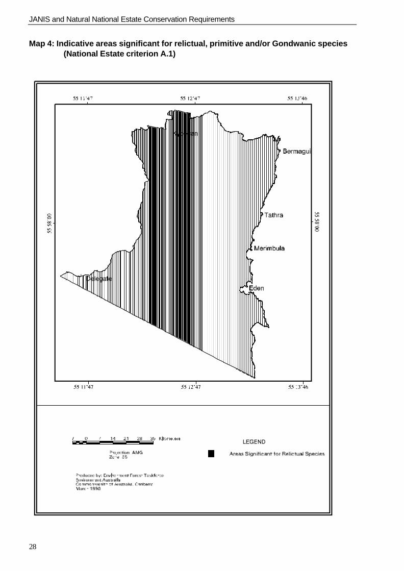
Relictual and/or Gondwanic flora species(A.1 Past processes) The opinion of the expert workshop was that areasof rainforest and mountain tops were the mostlikely habitat for relictual or Gondwanic species.
Threshold: All occurrences of Dry Rainforest>†5†hectares (all areas very small), and areas of>†20†hectares of other rainforest types were consideredto be above threshold. All of Bunga Head Rainforestwas included, as it is the only occurrence of thisrainforest type.
JANIS and Natural National Estate Conservation Requirements
14
Flora and fauna species endemic to region(A.1 Past processes) The workshop of experts identified all knownendemic flora species for the Eden region. Thereare no known endemic vertebrates in the Edenregion and this assessment gave no consideration toendemic invertebrates. Consequently thisassessment was confined to endemic flora.
Point locality information was plotted for all speciesand a 1 km2 was overlayed on this.
Threshold: All areas with two or more endemicspecies within a single grid or within two adjacentgrids were considered to be above threshold.
Flora species - disjunct populations(A.1 Past processes) All known occurrences of flora species withdisjunct populations in the Eden region wereidentified by expert opinion.
Point localities information for all identified specieswas plotted and a 1 km2 grid was overlayed on this.
Threshold: All areas with two or more specieswithin a single grid or within two adjacent gridswere considered to be above threshold.
Undisturbed catchments(A.2 Continuing processes) The methodology and results of this assessment arecovered in the report Extensive Natural NationalEstate Values: Eden CRA Region (EnvironmentAustralia 1998). Identification was based on anassessment of catchment disturbance defined bythe Wild Rivers Database.
Natural landscapes(B.1 Natural rarity) The methodology and results of this assessment arecovered in the report Extensive Natural NationalEstate Values: Eden CRA Region (EnvironmentAustralia 1998). Identification was based onbiophysical naturalness as defined by the NWI,with areas greater than 1,000 hectares and BN=5being considered to be above threshold.
Flora community diversity(A.3 Richness and diversity)
The method of identifying this value was based onprevious regional national estate assessments inother RFA regions.
The forest ecosystem layer was overlayed with a1†km2 grid. This grid size was chosen based on thecoverage of the data and the required resolution.
The number of unique ecosystem types in each gridwas determined. Multiple occurrences of anecosystem type in a grid and cleared land were notincluded.
Threshold: Grids with eight or more ecosystemtypes were considered to be of high diversity andabove threshold. (The count ranged from 1 - 15ecosystem types per grid cell.)
15
4.RESULTS
4.1 FOREST ECOSYSTEMS
Preliminary targets, based on total area for eachforest ecosystem, were calculated prior to theexpert panel workshop (i.e. pre 1750 vs extantforest ecosystem coverage) using the data layerobtained from the forest ecosystem mappingproject. The expert panel decided upon targetvalues for distribution and patch size, based on theirknowledge of the forest ecosystems and the areasin which they are located, other feasiblealternatives had limitations. Appendix 4.1 showsthe conservation targets obtained for each forestecosystem and summarises information provided bythe expert panel. Appendix 4.2 details the results ofthe expert panel workshop including areasidentified as being of National Estate significance.These results provide additional information toassist in preparations for negotiations.
4.2 SPECIES
The Response to Disturbance project providedinformation that was used to develop conservationrequirements for species. Environment Australia,State Forests of NSW and NSW National Parksand Wildlife Service were all jointly involved intasks associated with the Response to Disturbanceproject.
4.2.1 Fauna
Species targets
The following conservation requirement informationwas provided by the Response to Disturbanceproject;n review of fauna models with definitions of core,
intermediate and marginal habitat quality,n carrying capacity values,n habitat protection target areas,n minimum patch sizes,
n species subregions and number of patches persubregion,
n information on specific habitat requirements andassociated management recommendations.
Refer to, Appendix 4.3: Details of maps created forspecies with area targets, Appendix 4.4: Summaryof final agreed target areas and associatedinformation and Appendix 4.5: Habitat Models andSubregion Maps to see how fauna targets wereapplied spatially.
Some of the spatial and area targets developed inthe Response to Disturbance fauna expertworkshops were not defined clearly and needed tobe resolved prior to data preparation for C-Plan.These were:
n The total target areas for the Greater Gliderwere smaller than the sum of minimum patchsize areas allocated to the sub-regions withinEden. Thus the target area was increased by400 hectares to meet this sum.
n Some species required large target areas toadequately protect suitable habitat but thepatches allocated for reservation in theworkshops were considerably less than thetarget area. In order to meet the shortfall,SFNSW stream buffers and PreferredManagement Priority areas (PMPs) contributedto meet the total habitat protection target. Thespecies concerned were; the four forest owls,Tiger Quoll, Common Death Adder and all birdspecies except for the Red-browed Tree-creeper. See Appendix 4.4.
n Some species models had subregions identifiedfor management only or important for furthersurvey (i.e. they have no area targets). Since C-Plan required area targets to be assigned tosubregions, these areas are effectively the sameas any other area outside target associatedsubregions and thus these subregions were notincorporated in the final habitat models.
JANIS and Natural National Estate Conservation Requirements
16
n Habitat models for the Grey-headed Flying Foxand Koala were subject to some debate andwere finalised post-workshop throughnegotiations between stakeholders and faunaexperts. The Tiger Quoll model had to becorrected post-workshop as habitat qualitydefinitions were inadvertently assigned to thewrong vegetation types. This was amendedafter the workshops with one of the threeexperts present.
Preparing the data for C-Plan
The process for preparing this data is described asfollows:
n Species subregions identified in the response todisturbance workshop were digitised andclassified on screen using the appropriate faunamodel as a backdrop;
n Fauna models were “cleaned’ to remove anyfragments of modelled habitat less than 30% ofdouble the species home range. This ensuredthat isolated fragments not capable ofsupporting a population were not included in theC-Plan matrix. This process was the same asthat used during the NSW Interim AssessmentProcess;
n These processed fauna models were thenintersected with the planning unit layer toproduce a table giving hectares of each habitattype per planning unit;
Core, intermediate and marginal habitat quality wasmultiplied by the relevant carrying capacity values(ability of habitat to support species) defined in theResponse to Disturbance project. These values foreach habitat type were then summed to give a totalcarrying capacity for each planning unit. Thesevalues were then imported into the C-Plan matrix.
4.2.2 Flora
Appendix 4.6 contains the target table for significantflora species considered in the Response toDisturbance project. Each species has a target forreservation, indicating the number of populations ofthat species sought outside the current reserve system.This table also contains the rankings of the species’vulnerability to threatening processes and the order inwhich the species were to be entered into C-Plan.Vulnerability rankings or reservation requirementranks were considered in the negotiation process.
Approximately 20 species were not given a target asthere were no accurate location or ecological data
available. It was recommended that these species besurveyed in the ongoing Regional Forest Agreementassessment process.
During target setting, species that were considered tobe exceptional cases due to their unusual responses todisturbance were:
1. Hakea macreana, Santalum obtusifolium andCymbidium suave were considered by DougBinns and Michael Doherty to be of lowvulnerability thus one point was subtracted fromthe scores of these species.
2. Caladenia clarkiae, C. sp. aff reticulata, C.hunteriana and Pterostylis plumosa wereconsidered to be of exceptionally highvulnerability to threatening processes and thusone point was added to their rankings
4.3 OLD GROWTH
Appendix 4.7 contains the complete target table forold growth. Other results to come out of thisprocess to aid negotiations were a contextual layerof aesthetic old growth and recommendations fromthe expert panel to aid in negotiations (seeAppendix 3.2).
Increases in targets from 60% to 100% were doneon the basis of the JANIS criteria and objectives.Information relevant to specific objectives iscontained in Appendix 3.2.
4.3.1 Recommendations for determiningconservation requirements in future CRAs
A number of suggestions were made by the expertpanel to improve the derivation of conservationrequirements for old growth, such as:
n rule sets applied to old growth layers to obtaintargets for the Eden CRA area are specific tothis CRA region. The process needs to beexpanded and modified before being applied toother regions;
n vulnerability should be linked directly to targetadjustment;
n need to develop methods for analysingcontiguity and fragmentation of old growthforests in other regions; and
n improved fauna and flora species models shouldimprove the ability to derive high quality habitatold growth.
JANIS and Natural National Estate Conservation Requirements
17
4.4 WILDERNESS
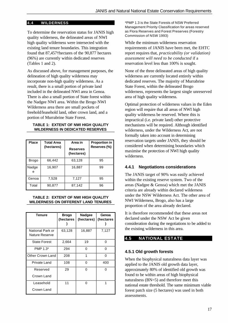
To determine the reservation status for JANIS highquality wilderness, the delineated areas of NWIhigh quality wilderness were intersected with theexisting land tenure boundaries. This integrationfound that 87,457†hectares of the 90,877 hectares(96%) are currently within dedicated reserves(Tables 1 and 2).
As discussed above, for management purposes, thedelineation of high quality wilderness mayincorporate non-high quality wilderness. As aresult, there is a small portion of private landincluded in the delineated NWI area in Genoa.There is also a small portion of State forest withinthe Nadgee NWI area. Within the Brogo NWIWilderness area there are small pockets offreehold/leasehold land, other crown land, and aportion of Murrabrine State Forest.
TABLE 1: EXTENT OF NWI HIGH QUALITYWILDERNESS IN DEDICATED RESERVES
Place Total Area(hectares)
Area in
Reserves(hectares)
Proportion inReserves (%)
Brogo 66,442 63,128 95
Nadgee
16,907 16,887 99
Genoa 7,528 7,127 95
Total 90,877 87,142 96
TABLE 2: EXTENT OF NWI HIGH QUALITYWILDERNESS ON DIFFERENT LAND TENURES
Tenure Brogo(hectares
)
Nadgee(hectares)
Genoa(hectares
)
National Park orNature Reserve
63,128 16,887 7,127
State Forest 2,664 19 0
PMP 1.3* 294 0 0
Other Crown Land 208 1 0
Private Land 108 0 400
Reserved
Crown Land
29 0 0
Leasehold
Crown Land
11 0 1
*PMP 1.3 is the State Forests of NSW PreferredManagement Priority Classification for areas reservedas Flora Reserves and Forest Preserves (ForestryCommission of NSW 1993)
While the minimum wilderness reservationrequirements of JANIS have been met, the EHTCreport requires that, practicability (or validation)assessment will need to be conducted if areservation level less than 100% is sought.
None of the three delineated areas of high qualitywilderness are currently located entirely withindedicated reserves. The majority of MurrabrineState Forest, within the delineated Brogowilderness, represents the largest single unreservedarea of high quality wilderness.
Optimal protection of wilderness values in the Edenregion will require that all areas of NWI highquality wilderness be reserved. Where this isimpractical (i.e. private land) other protectivemechanisms will be required. Although identifiedwilderness, under the Wilderness Act, are notformally taken into account in determiningreservation targets under JANIS, they should beconsidered when determining boundaries whichmaximise the protection of NWI high qualitywilderness.
4.4.1 Negotiations considerations
The JANIS target of 90% was easily achievedwithin the existing reserve system. Two of theareas (Nadgee & Genoa) which met the JANIScriteria are already within declared wildernessunder the NSW Wilderness Act. The other area ofNWI Wilderness, Brogo, also has a largeproportion of the area already declared.
It is therefore recommended that these areas notdeclared under the NSW Act be givenconsideration during the negotiations to be added tothe existing wilderness in this area.
4.5 NATIONAL ESTATE
4.5.1 Old growth forests
When the biophysical naturalness data layer wasapplied to the JANIS old growth data layer,approximately 80% of identified old growth wasfound to be within areas of high biophysicalnaturalness (BN=5) and therefore meet thisnational estate threshold. The same minimum viableforest patch size (5 hectares) was used in bothassessments.
JANIS and Natural National Estate Conservation Requirements
18
Approximately one third of the remaining area ofold growth forest below the high biophysicalnaturalness threshold (i.e. 8% of the total oldgrowth area) consisted of rare communities of oldgrowth (Criteria B.1). These rare old growth forestcommunities are also a JANIS criteria which havea 100% target for inclusion in a CAR reserve. Alloccurrences of rare old growth were considered tomeet the national estate threshold.
A separate national estate old growth map was notconsidered necessary given the high congruence(approximately 88%) between the JANIS oldgrowth data layer and indicative areas of nationalestate old growth value.
4.5.2 Wilderness
Areas with a minimum NWI rating of 12 and aminimum size of 8,000 hectares were considered tohave significant national estate wilderness value.These areas are detailed in the report WildernessAssessment and Identification in the EdenRegion (Environment Australia and National Parksand Wildlife Service, 1997).
4.5.3 Principal characteristics ofvegetation class
The expert panel identified significant areas thatwere notable representative examples of a numberof forest ecosystems. These areas are detailed inAppendix 4.2. The expert panel also identifiedspecific flora communities as being significant.These were:
n all areas of rainforest greater than 20 hectares;
n all flora communities occurring on rhyolite andlowland basalt (Lochiel group).
Where the expert panel was not able to identifyspecific outstanding examples of particular floracommunities, they advised that forest ecosystemsidentified for inclusion in the CAR reserve systemwould be of sufficient quality to meet the nationalestate criteria for those flora communities.
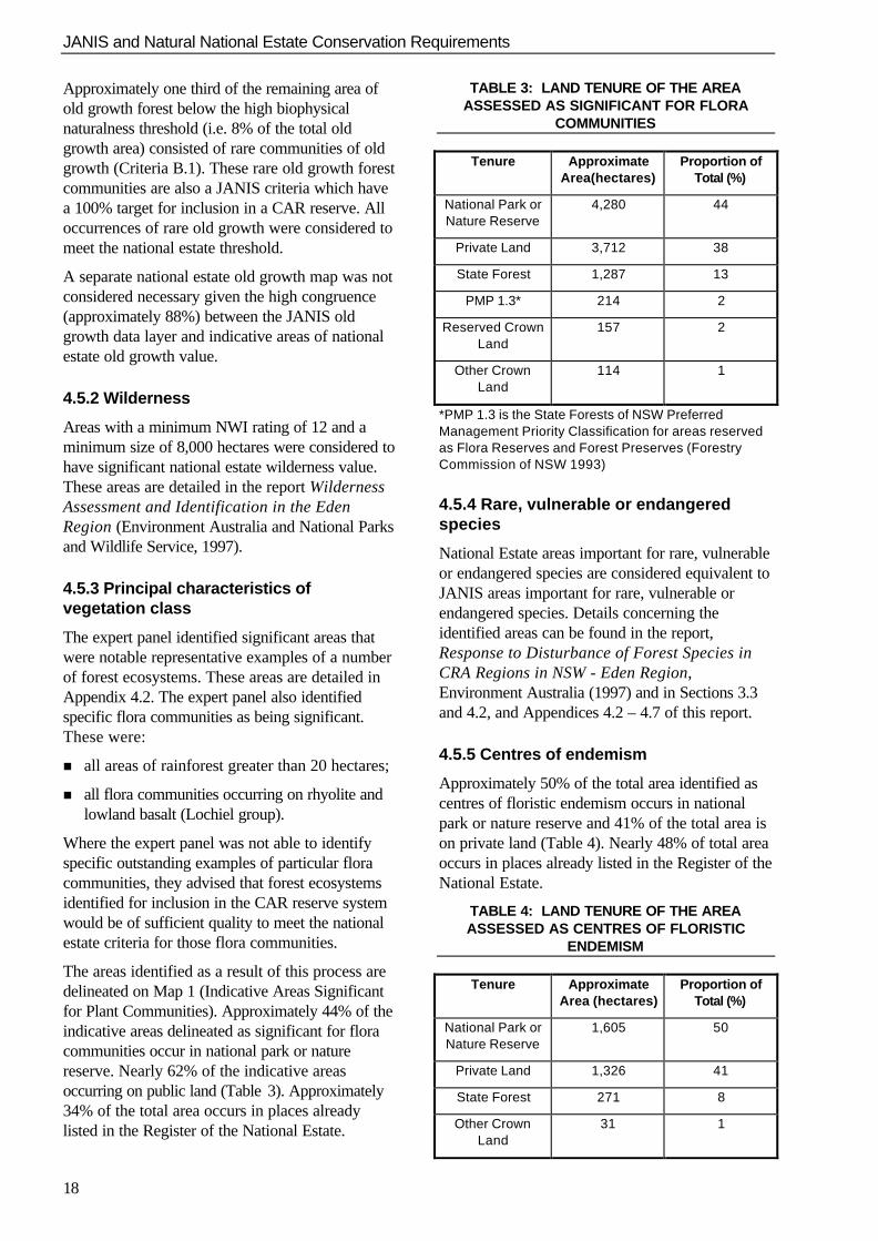
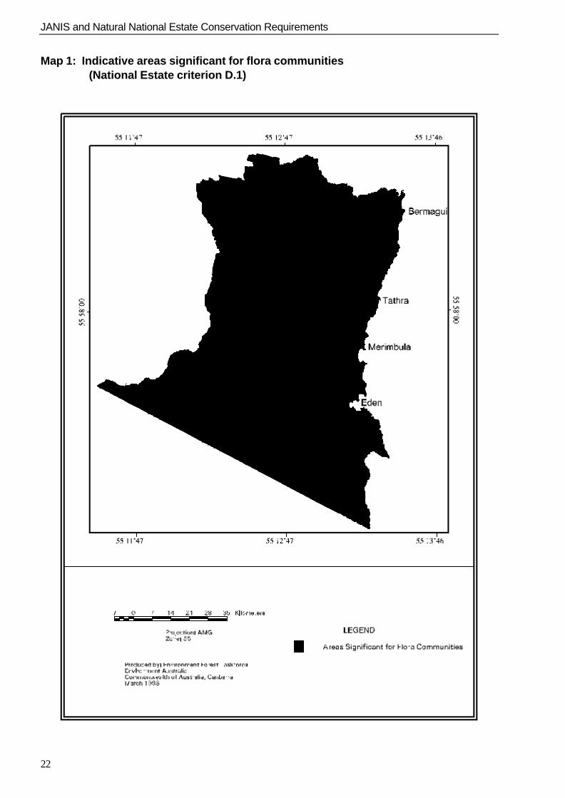
The areas identified as a result of this process aredelineated on Map 1 (Indicative Areas Significantfor Plant Communities). Approximately 44% of theindicative areas delineated as significant for floracommunities occur in national park or naturereserve. Nearly 62% of the indicative areasoccurring on public land (Table 3). Approximately34% of the total area occurs in places alreadylisted in the Register of the National Estate.
TABLE 3: LAND TENURE OF THE AREAASSESSED AS SIGNIFICANT FOR FLORA
COMMUNITIES
Tenure ApproximateArea(hectares)
Proportion ofTotal (%)
National Park orNature Reserve
4,280 44
Private Land 3,712 38
State Forest 1,287 13
PMP 1.3* 214 2
Reserved CrownLand
157 2
Other CrownLand
114 1
*PMP 1.3 is the State Forests of NSW PreferredManagement Priority Classification for areas reservedas Flora Reserves and Forest Preserves (ForestryCommission of NSW 1993)
4.5.4 Rare, vulnerable or endangeredspecies
National Estate areas important for rare, vulnerableor endangered species are considered equivalent toJANIS areas important for rare, vulnerable orendangered species. Details concerning theidentified areas can be found in the report,Response to Disturbance of Forest Species inCRA Regions in NSW - Eden Region,Environment Australia (1997) and in Sections 3.3and 4.2, and Appendices 4.2 – 4.7 of this report.
4.5.5 Centres of endemism
Approximately 50% of the total area identified ascentres of floristic endemism occurs in nationalpark or nature reserve and 41% of the total area ison private land (Table 4). Nearly 48% of total areaoccurs in places already listed in the Register of theNational Estate.
TABLE 4: LAND TENURE OF THE AREAASSESSED AS CENTRES OF FLORISTIC
ENDEMISM
Tenure ApproximateArea (hectares)
Proportion ofTotal (%)
National Park orNature Reserve
1,605 50
Private Land 1,326 41
State Forest 271 8
Other CrownLand
31 1
JANIS and Natural National Estate Conservation Requirements
19
Reserved CrownLand
6 <1
The identified Centres of Endemism are shown onMap 2. See Appendix 4.8 for a list of endemic floraspecies for the Eden CRA region.
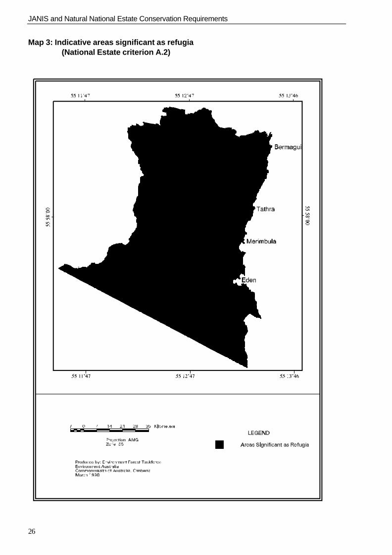
4.5.6 Refugia
Forest communities, mountain tops and steepgradients delineated as refugia or potential refugiaare listed in Table 5 and delineated on Map 3.
TABLE 5: TYPES OF AREAS DELINEATED ASREFUGIA
Refugia to Long Term Climatic Change
Rainforest included: Bunga Head Rainforest Coastal Warm Temperate Rainforest Cool Temperate Rainforest Dry Rainforest Hinterland Warm Temperate Rainforest Myanba Eucalypt - Fig Forest Isolated mountain tops included: Burragate Peak - Jingera Rock (areas above ~750 m) Mount Imlay (areas above ~800 m) Mount Poole (areas above ~675 m) Mumbulla Mountain (areas above ~675 m) Murrabrine (Mountain) (areas above ~725 m) Nadgee Mountain (areas above ~450 m) Nungatta Plateau (areas above ~800 m) Waalimma Peak (areas above ~625 m) Wolumla Peak (areas above ~675 m) Nalbaugh Plateau (areas above ~975 m) Steep Gradients included: Areas with steep (>308) altitudinal gradients.
Drought Refugia
Southern Riparian Scrub Northern Riparian Scrub Riverine Forest Wet Old Growth Forest Mountain Wet Layered Forest (Shining Gum) Mountain Wet Layered Forest (Brown Barrel) Tantawangalo Wet Shrub Forest Mountain Wet Fern Forest (Brown Barrel-Gum) Hinterland Wet Fern Forest (Gum) Hinterland Wet Shrub Forest (Stringybark) Mountain Wet Herb Forest (Messmate-Gum) Basalt Wet Herb Forest (Brown Barrel-Gum) Flats Wet Herb Forest (Ribbon Gum) Brogo Wet Vine Forest (Red Gum) Brogo Wet Shrub Forest (Peppermint-Blue Box) Wadbilliga Wet Shrub Forest Swamp Heath Lowland Swamp Swamp Forest Subalpine Bog
Floodplain Wetland Estuarine Wetland
Fire Refugia
Identified rainforest, wetlands and mountain tops.
JANIS and Natural National Estate Conservation Requirements
20
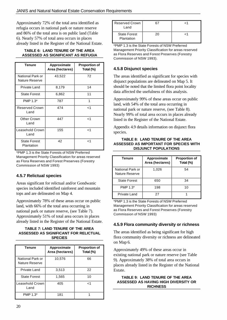
Approximately 72% of the total area identified asrefugia occurs in national park or nature reserveand 86% of the total area is on public land (Table6). Nearly 57% of total area occurs in placesalready listed in the Register of the National Estate.
TABLE 6: LAND TENURE OF THE AREAASSESSED AS SIGNIFICANT AS REFUGIA
Tenure Approximate
Area (hectares) Proportion of
Total (%)
National Park orNature Reserve
43,522 72
Private Land 8,179 14
State Forest 6,862 11
PMP 1.3* 787 1
Reserved CrownLand
474 <1
Other CrownLand
447 <1
Leasehold CrownLand
155 <1
State ForestPlantation
42 <1
*PMP 1.3 is the State Forests of NSW PreferredManagement Priority Classification for areas reservedas Flora Reserves and Forest Preserves (ForestryCommission of NSW 1993)
4.5.7 Relictual species
Areas significant for relictual and/or Gondwanicspecies included identified rainforest and mountaintops and are delineated on Map 4.
Approximately 78% of these areas occur on publicland, with 66% of the total area occurring innational park or nature reserve, (see Table 7).Approximately 51% of total area occurs in placesalready listed in the Register of the National Estate.
TABLE 7: LAND TENURE OF THE AREAASSESSED AS SIGNIFICANT FOR RELICTUAL
SPECIES
Tenure ApproximateArea (hectares)
Proportion ofTotal (%)
National Park orNature Reserve
10,576 66
Private Land 3,513 22
State Forest 1,565 10
Leasehold CrownLand
405 <1
PMP 1.3* 181 1
Reserved CrownLand
67 <1
State ForestPlantation
20 <1
*PMP 1.3 is the State Forests of NSW PreferredManagement Priority Classification for areas reservedas Flora Reserves and Forest Preserves (ForestryCommission of NSW 1993).
4.5.8 Disjunct species
The areas identified as significant for species withdisjunct populations are delineated on Map 5. Itshould be noted that the limited flora point localitydata affected the usefulness of this analysis.
Approximately 99% of these areas occur on publicland, with 54% of the total area occurring innational park or nature reserve, (see Table 8).Nearly 99% of total area occurs in places alreadylisted in the Register of the National Estate.
Appendix 4.9 details information on disjunct floraspecies.
TABLE 8: LAND TENURE OF THE AREAASSESSED AS IMPORTANT FOR SPECIES WITH
DISJUNCT POPULATIONS
Tenure ApproximateArea (hectares)
Proportion ofTotal (%)
National Park orNature Reserve
1,026 54
State Forest 650 34
PMP 1.3* 198 10
Private Land 27 1
*PMP 1.3 is the State Forests of NSW PreferredManagement Priority Classification for areas reservedas Flora Reserves and Forest Preserves (ForestryCommission of NSW 1993)
4.5.9 Flora community diversity or richness
The areas identified as being significant for highflora community diversity or richness are delineatedon Map 6.
Approximately 49% of these areas occur inexisting national park or nature reserve (see Table9). Approximately 38% of total area occurs inplaces already listed in the Register of the NationalEstate.
TABLE 9: LAND TENURE OF THE AREAASSESSED AS HAVING HIGH DIVERSITY OR
RICHNESS

JANIS and Natural National Estate Conservation Requirements
21
Tenure ApproximateArea (hectares)
Proportion ofTotal (%)
National Park orNature Reserve
37,195 49
State Forest 22,562 30
Private Land 13,871 18
PMP 1.3* 896 1
State ForestPlantation
641 1
Reserved CrownLand
422 <1
Other Crown 308 <1
Land
Leasehold CrownLand
206 <1
Coastal Inlet 81 <1
*PMP 1.3 is the State Forests of NSW PreferredManagement Priority Classification for areas reservedas Flora Reserves and Forest Preserves (ForestryCommission of NSW 1993).
JANIS and Natural National Estate Conservation Requirements
22
Map 1: Indicative areas significant for flora communities(National Estate criterion D.1)

JANIS and Natural National Estate Conservation Requirements
23

JANIS and Natural National Estate Conservation Requirements
24
Map 2: Indicative areas significant as centres of floristic endemism(National Estate criterion A.1)

JANIS and Natural National Estate Conservation Requirements
25
JANIS and Natural National Estate Conservation Requirements
26
Map 3: Indicative areas significant as refugia(National Estate criterion A.2)

JANIS and Natural National Estate Conservation Requirements
27
JANIS and Natural National Estate Conservation Requirements
28
Map 4: Indicative areas significant for relictual, primitive and/or Gondwanic species(National Estate criterion A.1)

JANIS and Natural National Estate Conservation Requirements
29

JANIS and Natural National Estate Conservation Requirements
30
Map 5: Indicative areas significant for species with disjunct populations(National Estate criterion A.1)

JANIS and Natural National Estate Conservation Requirements
31

JANIS and Natural National Estate Conservation Requirements
32
Map 6: Indicative areas significant for vegetation diversity or richness(National Estate criterion A.3)

JANIS and Natural National Estate Conservation Requirements
33
34
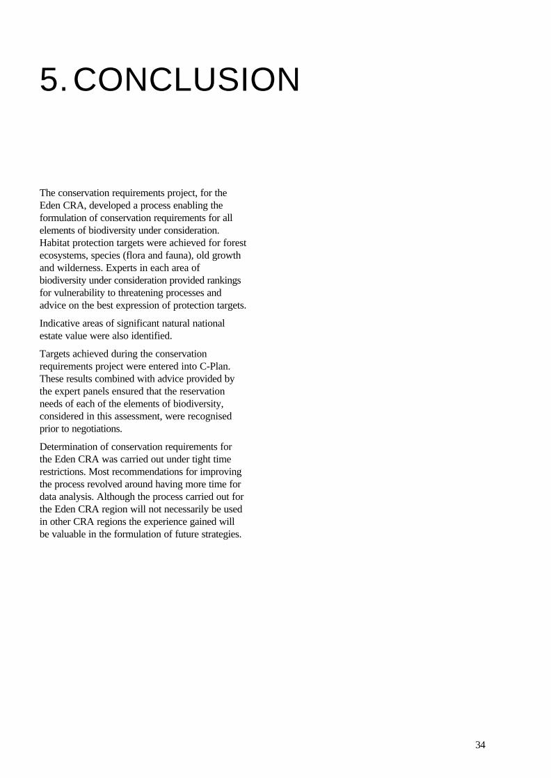
5.CONCLUSION
The conservation requirements project, for theEden CRA, developed a process enabling theformulation of conservation requirements for allelements of biodiversity under consideration.Habitat protection targets were achieved for forestecosystems, species (flora and fauna), old growthand wilderness. Experts in each area ofbiodiversity under consideration provided rankingsfor vulnerability to threatening processes andadvice on the best expression of protection targets.
Indicative areas of significant natural nationalestate value were also identified.
Targets achieved during the conservationrequirements project were entered into C-Plan.These results combined with advice provided bythe expert panels ensured that the reservationneeds of each of the elements of biodiversity,considered in this assessment, were recognisedprior to negotiations.
Determination of conservation requirements forthe Eden CRA was carried out under tight timerestrictions. Most recommendations for improvingthe process revolved around having more time fordata analysis. Although the process carried out forthe Eden CRA region will not necessarily be usedin other CRA regions the experience gained willbe valuable in the formulation of future strategies.

JANIS and Natural National Estate Conservation Requirements for the Eden Region
35
36
6.REFERENCES
Commonwealth of Australia (1992) National ForestPolicy Statement - a new focus for Australia’sforests. Advance Press Pty Ltd, Perth.
Commonwealth of Australia (1997) JointANZECC/MCFFA National Forest PolicyStatement Implementation sub-committee (JANIS),Nationally Agreed Criteria for the establishment ofa Comprehensive, Adequate and RepresentativeReserve System for Forests in Australia. Canberra
Environment and Heritage Technical Committee(1997) Technical Framework for environment andheritage assessments in the NSW CRA/RFAprocess.
Environment Australia (1997). Response toDisturbance of Forest Species in CRA Regionsin NSW - Eden Region. Report to the Resourceand Conservation Assessment Council. Resourceand Conservation Division, Department of UrbanAffairs and Planning, Sydney.
Environment Australia and National Parks andWildlife Service (1997). Wilderness Assessmentand Identification in the Eden Region. Report tothe Resource and Conservation AssessmentCouncil. Resource and Conservation Division,Department of Urban Affairs and Planning,Sydney.
Forestry Commission of NSW (1993). PMPPreferred Management Priority Classification.Circular No. 1100. Forest Planning andEnvironment Series No. 2. Forestry Commission ofNSW, Sydney.
National Parks and Wildlife Service (1997). OldGrowth Forest Related Projects Eden CRARegion. Report to the Resource and ConservationAssessment Council. Resource and ConservationDivision, Department of Urban Affairs andPlanning, Sydney.

JANIS and Natural National Estate Conservation Requirements for the Eden Region
37
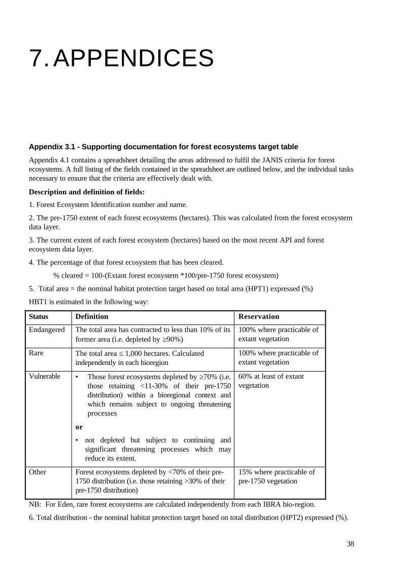
38
7.APPENDICES
Appendix 3.1 - Supporting documentation for forest ecosystems target table
Appendix 4.1 contains a spreadsheet detailing the areas addressed to fulfil the JANIS criteria for forestecosystems. A full listing of the fields contained in the spreadsheet are outlined below, and the individual tasksnecessary to ensure that the criteria are effectively dealt with.
Description and definition of fields:
1. Forest Ecosystem Identification number and name.
2. The pre-1750 extent of each forest ecosystems (hectares). This was calculated from the forest ecosystemdata layer.
3. The current extent of each forest ecosystem (hectares) based on the most recent API and forestecosystem data layer.
4. The percentage of that forest ecosystem that has been cleared.
% cleared = 100-(Extant forest ecosystem *100/pre-1750 forest ecosystem)
5. Total area = the nominal habitat protection target based on total area (HPT1) expressed (%)
HBT1 is estimated in the following way:
Status Definition Reservation
Endangered The total area has contracted to less than 10% of itsformer area (i.e. depleted by ≥90%)
100% where practicable ofextant vegetation
Rare The total area ≤ 1,000 hectares. Calculatedindependently in each bioregion
100% where practicable ofextant vegetation
Vulnerable • Those forest ecosystems depleted by ≥70% (i.e.those retaining <11-30% of their pre-1750distribution) within a bioregional context andwhich remains subject to ongoing threateningprocesses
or
• not depleted but subject to continuing andsignificant threatening processes which mayreduce its extent.
60% at least of extantvegetation
Other Forest ecosystems depleted by <70% of their pre-1750 distribution (i.e. those retaining >30% of theirpre-1750 distribution)
15% where practicable ofpre-1750 vegetation
NB: For Eden, rare forest ecosystems are calculated independently from each IBRA bio-region.
6. Total distribution - the nominal habitat protection target based on total distribution (HPT2) expressed (%).
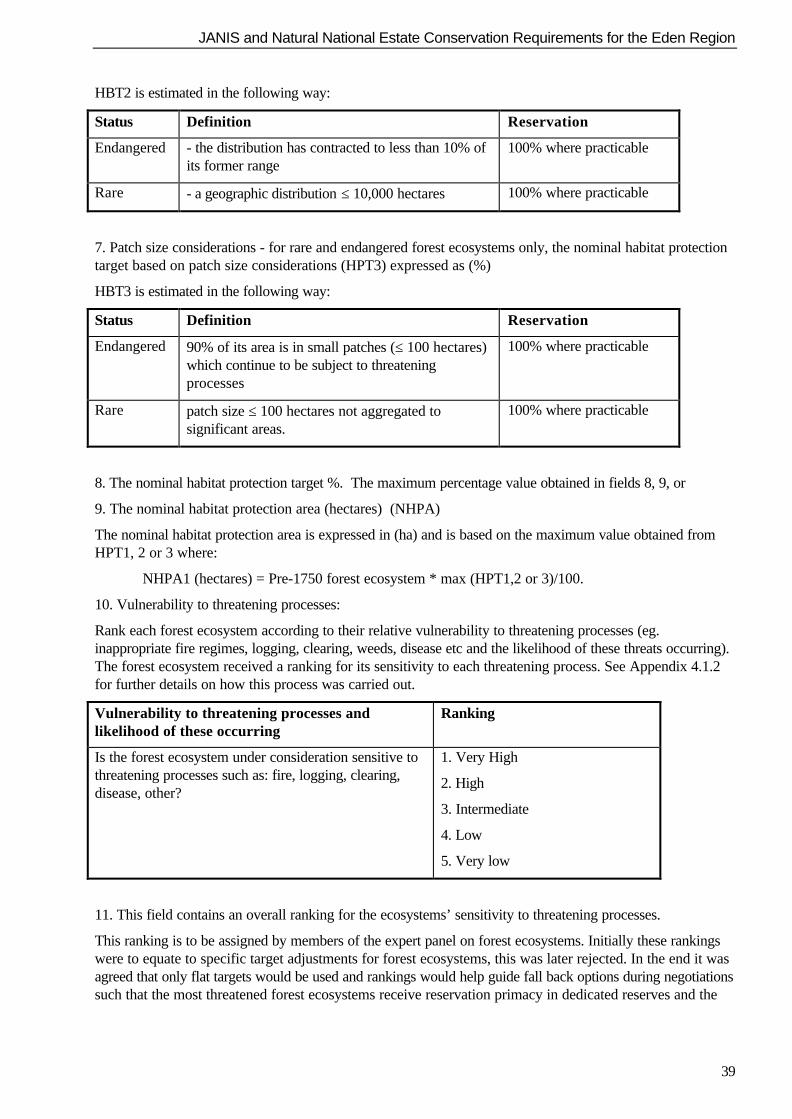
JANIS and Natural National Estate Conservation Requirements for the Eden Region
39
HBT2 is estimated in the following way:
Status Definition Reservation
Endangered - the distribution has contracted to less than 10% ofits former range
100% where practicable
Rare - a geographic distribution ≤ 10,000 hectares 100% where practicable
7. Patch size considerations - for rare and endangered forest ecosystems only, the nominal habitat protectiontarget based on patch size considerations (HPT3) expressed as (%)
HBT3 is estimated in the following way:
Status Definition Reservation
Endangered 90% of its area is in small patches (≤ 100 hectares)which continue to be subject to threateningprocesses
100% where practicable
Rare patch size ≤ 100 hectares not aggregated tosignificant areas.
100% where practicable
8. The nominal habitat protection target %. The maximum percentage value obtained in fields 8, 9, or
9. The nominal habitat protection area (hectares) (NHPA)
The nominal habitat protection area is expressed in (ha) and is based on the maximum value obtained fromHPT1, 2 or 3 where:
NHPA1 (hectares) = Pre-1750 forest ecosystem * max (HPT1,2 or 3)/100.
10. Vulnerability to threatening processes:
Rank each forest ecosystem according to their relative vulnerability to threatening processes (eg.inappropriate fire regimes, logging, clearing, weeds, disease etc and the likelihood of these threats occurring).The forest ecosystem received a ranking for its sensitivity to each threatening process. See Appendix 4.1.2for further details on how this process was carried out.
Vulnerability to threatening processes andlikelihood of these occurring
Ranking
Is the forest ecosystem under consideration sensitive tothreatening processes such as: fire, logging, clearing,disease, other?
1. Very High
2. High
3. Intermediate
4. Low
5. Very low
11. This field contains an overall ranking for the ecosystems’ sensitivity to threatening processes.
This ranking is to be assigned by members of the expert panel on forest ecosystems. Initially these rankingswere to equate to specific target adjustments for forest ecosystems, this was later rejected. In the end it wasagreed that only flat targets would be used and rankings would help guide fall back options during negotiationssuch that the most threatened forest ecosystems receive reservation primacy in dedicated reserves and the

JANIS and Natural National Estate Conservation Requirements
40
least threatened receive greater levels of informal reservation and or prescriptive management where this isjudged desirable.
12. Spatial consideration - replication across the geographic range:
Is the forest ecosystem adequately replicated across its geographic range? Ensure that it is and identify theappropriate areas on the supplied map. This will be done manually.
13. Spatial consideration - sampling of full range of biological variation:
Has the full range of biological variation been sampled for this forest ecosystem? (e.g. altitudinal, latitudinal,rainfall etc.). Again, ensure that the likely gradients are identified and demonstrate how the sampling of thesecan be best achieved across its distribution. This will be done manually.
NB: Fields 12, 13, and 14 identify those forest ecosystems that require special consideration duringnegotiation due to either their patchy distribution across the landscape, where profound biological variationexists or where the “best bits” are unlikely to receive consideration. For these forest ecosystems, specificrecommendations will need to be made to assist manual operations during negotiations.
14. National Estate:
Are the national estate criteria adequately addressed by the JANIS criteria identified above? (i.e. have weidentified the best bits?) Expert panel to highlight areas that may be of national estate significance
15. Maximum target value in % columns 5, 6, or 7.
16\17. Shows the targets that should be applied to either the pre-1750 vegetation or the extant vegetationcoverage.
18. Shows the JANIS target of 15% of pre-1750 distribution in hectares for all forest ecosystems.
19. Shows the area in hectares for those forest ecosystems with 60 or 100% targets.
20. Final target in hectares. i.e. the greatest value from columns 18 or 19.
21. Comments and suggested management practices to ameliorate threatening processes.
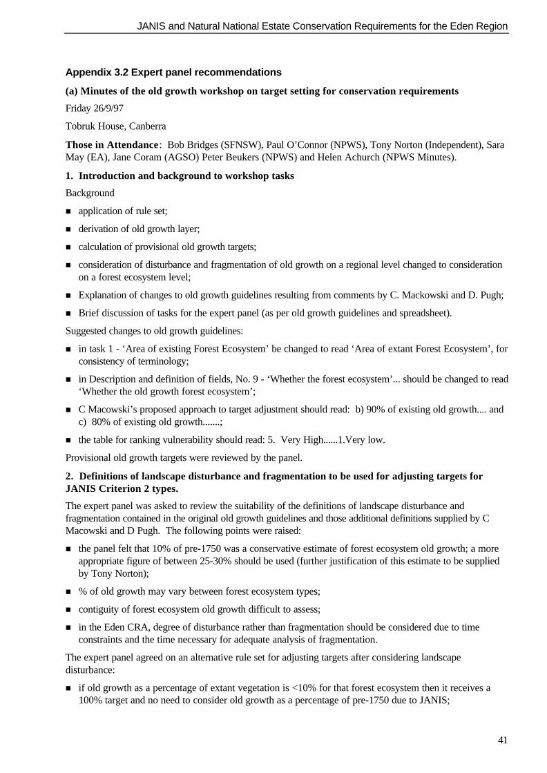
JANIS and Natural National Estate Conservation Requirements for the Eden Region
41
Appendix 3.2 Expert panel recommendations
(a) Minutes of the old growth workshop on target setting for conservation requirements
Friday 26/9/97
Tobruk House, Canberra
Those in Attendance: Bob Bridges (SFNSW), Paul O’Connor (NPWS), Tony Norton (Independent), SaraMay (EA), Jane Coram (AGSO) Peter Beukers (NPWS) and Helen Achurch (NPWS Minutes).
1. Introduction and background to workshop tasks
Background
n application of rule set;
n derivation of old growth layer;
n calculation of provisional old growth targets;
n consideration of disturbance and fragmentation of old growth on a regional level changed to considerationon a forest ecosystem level;
n Explanation of changes to old growth guidelines resulting from comments by C. Mackowski and D. Pugh;
n Brief discussion of tasks for the expert panel (as per old growth guidelines and spreadsheet).
Suggested changes to old growth guidelines:
n in task 1 - ‘Area of existing Forest Ecosystem’ be changed to read ‘Area of extant Forest Ecosystem’, forconsistency of terminology;
n in Description and definition of fields, No. 9 - ‘Whether the forest ecosystem’... should be changed to read‘Whether the old growth forest ecosystem’;
n C Macowski’s proposed approach to target adjustment should read: b) 90% of existing old growth.... andc) 80% of existing old growth.......;
n the table for ranking vulnerability should read: 5. Very High......1.Very low.
Provisional old growth targets were reviewed by the panel.
2. Definitions of landscape disturbance and fragmentation to be used for adjusting targets forJANIS Criterion 2 types.
The expert panel was asked to review the suitability of the definitions of landscape disturbance andfragmentation contained in the original old growth guidelines and those additional definitions supplied by CMacowski and D Pugh. The following points were raised:
n the panel felt that 10% of pre-1750 was a conservative estimate of forest ecosystem old growth; a moreappropriate figure of between 25-30% should be used (further justification of this estimate to be suppliedby Tony Norton);
n % of old growth may vary between forest ecosystem types;
n contiguity of forest ecosystem old growth difficult to assess;
n in the Eden CRA, degree of disturbance rather than fragmentation should be considered due to timeconstraints and the time necessary for adequate analysis of fragmentation.
The expert panel agreed on an alternative rule set for adjusting targets after considering landscapedisturbance:
n if old growth as a percentage of extant vegetation is <10% for that forest ecosystem then it receives a100% target and no need to consider old growth as a percentage of pre-1750 due to JANIS;
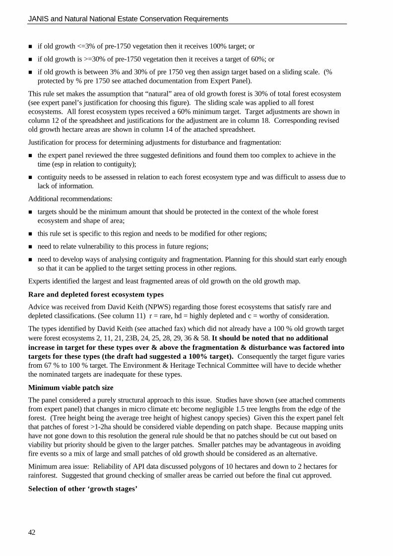
JANIS and Natural National Estate Conservation Requirements
42
n if old growth <=3% of pre-1750 vegetation then it receives 100% target; or
n if old growth is >=30% of pre-1750 vegetation then it receives a target of 60%; or
n if old growth is between 3% and 30% of pre 1750 veg then assign target based on a sliding scale. (%protected by % pre 1750 see attached documentation from Expert Panel).
This rule set makes the assumption that “natural” area of old growth forest is 30% of total forest ecosystem(see expert panel’s justification for choosing this figure). The sliding scale was applied to all forestecosystems. All forest ecosystem types received a 60% minimum target. Target adjustments are shown incolumn 12 of the spreadsheet and justifications for the adjustment are in column 18. Corresponding revisedold growth hectare areas are shown in column 14 of the attached spreadsheet.
Justification for process for determining adjustments for disturbance and fragmentation:
n the expert panel reviewed the three suggested definitions and found them too complex to achieve in thetime (esp in relation to contiguity);
n contiguity needs to be assessed in relation to each forest ecosystem type and was difficult to assess due tolack of information.
Additional recommendations:
n targets should be the minimum amount that should be protected in the context of the whole forestecosystem and shape of area;
n this rule set is specific to this region and needs to be modified for other regions;
n need to relate vulnerability to this process in future regions;
n need to develop ways of analysing contiguity and fragmentation. Planning for this should start early enoughso that it can be applied to the target setting process in other regions.
Experts identified the largest and least fragmented areas of old growth on the old growth map.
Rare and depleted forest ecosystem types
Advice was received from David Keith (NPWS) regarding those forest ecosystems that satisfy rare anddepleted classifications. (See column 11) r = rare, hd = highly depleted and c = worthy of consideration.
The types identified by David Keith (see attached fax) which did not already have a 100 % old growth targetwere forest ecosystems 2, 11, 21, 23B, 24, 25, 28, 29, 36 & 58. It should be noted that no additionalincrease in target for these types over & above the fragmentation & disturbance was factored intotargets for these types (the draft had suggested a 100% target). Consequently the target figure variesfrom 67 % to 100 % target. The Environment & Heritage Technical Committee will have to decide whetherthe nominated targets are inadequate for these types.
Minimum viable patch size
The panel considered a purely structural approach to this issue. Studies have shown (see attached commentsfrom expert panel) that changes in micro climate etc become negligible 1.5 tree lengths from the edge of theforest. (Tree height being the average tree height of highest canopy species) Given this the expert panel feltthat patches of forest >1-2ha should be considered viable depending on patch shape. Because mapping unitshave not gone down to this resolution the general rule should be that no patches should be cut out based onviability but priority should be given to the larger patches. Smaller patches may be advantageous in avoidingfire events so a mix of large and small patches of old growth should be considered as an alternative.
Minimum area issue: Reliability of API data discussed polygons of 10 hectares and down to 2 hectares forrainforest. Suggested that ground checking of smaller areas be carried out before the final cut approved.
Selection of other ‘growth stages’
JANIS and Natural National Estate Conservation Requirements for the Eden Region
43
The guidelines suggested that the expert panel consider which other growth stages should be selected whenthe forest ecosystem target exceeds the old growth target so as to ensure temporal viability.
Suggestions from the panel were:
n Bob Bridges - select old growth and the rest should be a balance through age groups
n Jane Coram & Tony Norton - should select the oldest stands because it is impossible to protect areascompletely from disturbance. It is then highly likely that we will end up with a range of successional ageswithout trying to preserve them.
n Jane Coram - an alternative to old growth could be disturbed old forest or undisturbed mature.
n Tony Norton - could look at each on a case by case basis
n Jane Coram - Because not a lot of disturbed old forest, undisturbed mature forest is more likely to beintact from disturbance (weeds, ferals etc).
The panel agreed that preference of selection should be old growth, then undisturbed mature, then disturbedold forest, and then to disturbed mature forest.
Sensitivity to threatening processes
It was agreed by the panel that the vulnerability rankings for each forest ecosystem, derived during the forestecosystem workshop, be applied to old growth in those forest ecosystem types. It was highlighted that oldgrowth would incur a greater vulnerability to these processes but lack of information prevents its separationfrom other growth stages. Appropriate buffering for protection of old growth patches was not considered inthe workshop. Experts felt that this needed to be dealt with in the RFA’s. Tony Norton will supplyinformation re: buffering requirements for plans of management.
(See Minutes of Forest Ecosystem Expert Workshop Appendix 4.2 for explanation of vulnerabilityrankings)
Spatial considerations
Suggestions:
n Select old growth throughout its range if 100% target is not achieved;
n look at in a contiguous context, i.e. preferentially select old growth in undisturbed catchments;
n keep contiguity with undisturbed mature forests;
n selecting intact old growth areas irrespective of forest ecosystem types;
n pick up largest sections of old growth rather than individual forest ecosystem approach. May need to giveand take a little on targets in order to achieve this;
n maximise contiguity and minimise fragmentation in consideration of tenure.
High quality habitat old growth
On the day of the workshop the high quality habitat layer for fauna species was not complete (we only had 12species) so the intersection of this layer with the old growth was not possible. The expert panel noted theEnvironment & Heritage Technical Committee minutes from 12/9/97 to identify areas of high quality habitatold growth for a 100% conservation target & preferentially select these areas. NPWS advised that scalingtargets according to the draft would not be possible due to the lack of the layer, however, selection of theseareas was probably best achieved by having a high quality habitat old growth layer within C-Plan with theabove target.
Aesthetic old growth
NPWS advised the workshop that an aesthetic layer had been generated (Commonwealth responsible forthis) and that it had been intersected with the old growth layer. This identified 103 hectares of aesthetic old

JANIS and Natural National Estate Conservation Requirements
44
growth within the Eden CRA region. The panel noted the suggestion that these areas receive a 100% targetfrom the Environment & Heritage Technical Committee minutes 12/9/97.
Comments from Brian Brooker (FPA)
Brian Brooker’s comments received during the meeting were circulated to the workshop. The expert panelthought the above discussion and associated documentation would deal with the FPA’s concerns.
JANIS and Natural National Estate Conservation Requirements for the Eden Region
45
Appendix 3.2(b) Old growth forest conservation options - Eden region, NSW
Introduction
An expert panel comprising Ms Jane Coram (AGSO, Canberra) and Professor Tony Norton (CSU,Canberra) was established to comment on conservation options for old growth forest in the Eden region ofNSW as part of the CRA process. The experts met for one day in Canberra on 26 September 1997 in thepresence of Mr Paul O'Connor, Ms Helen Achurch, and Mr Max Beukers (NSW NPWS), Mr Bob Bridges(State Forests of NSW), and Ms Sarah May and Mr Karl Bossard (Environment Australia).
The primary aims of the expert panel were to:
• evaluate the provisional old growth targets for each forest ecosystem;
• rank old growth types for each forest ecosystem from those most vulnerable and likely to be impacted tothose least vulnerable and least likely to be impacted;
• identify the largest and least fragmented areas of old growth forest;
• evaluate the potential for representation of old growth forest across the geographic range of each forestecosystem; and
• evaluate/develop conservation mechanisms to ensure the long term protection of old growth forest.
Each of the above aims were considered by the experts in consultation with all other participants of themeeting.
Provisional old growth targets for each forest ecosystem
The expert panel was asked to review the suitability of two proposed (and three modified) definitions oflandscape disturbance and fragmentation for determining conservation targets (as detailed in the revised oldgrowth conservation requirements version 25/9/97).
The expert panel considered that the figures used in the proposed definitions were quite arbitrary, and that thedefinitions of fragmentation and contiguity needed to be considered on an ecosystem basis, which wasimpossible within the time constraints of this exercise. These tabled approaches (and proposed modifications)to assigning reservation targets for old growth forest ecosystems were therefore put aside in favour of a morestraight forward approach that required only one assumption.
The JANIS Conservation and Natural National Estate requirements for ecosystem protection establishedtargets of 100% reservation levels where less than 10% of the pre-1750 distribution of a forest ecosystemremains. Assuming that 30% of any pre-1750 forest ecosystem comprised old growth forest (discussedbelow), this translates to a target of 100% reservation levels where less than 3% of the pre-1750 distributionof a forest ecosystem is old growth forest. Furthermore, the JANIS requirement for protection of old growthforest established a minimum level of 60% of extant old growth forest of each ecosystem. This level shouldbe applied where the extent of old growth forest is equivalent to pre-1750 levels (that is, 30% of the pre-1750extent of each ecosystem). Using these JANIS targets as fixed points defining the ends of a sliding scale, theexperts recommended that:
1. the old growth conservation target for each forest ecosystem be calculated using the function:
O = 100-((I-3)/27)x40, where
O = the proportion of extant old growth forest which should be protected, and
I = the area of extant candidate old growth forest expressed as a percentage of the calculated pre-1750distribution of each forest ecosystem.
except
when I<3% where the target automatically becomes 100% (ie. to fulfil the JANIS requirement for 100%reservation when <10% remains of the pre-1750 extent of a forest ecosystem);
JANIS and Natural National Estate Conservation Requirements
46
and I>30 where the target is fixed at a minimum of 60% (ie. to fulfil the JANIS requirement for 60%minimum reservation).
The assumption that 30% of a forest ecosystem may support old growth forest is based on a limited, butscientifically-based range of observations from Australia, USA, Canada and Chile (eg. BC Forest PracticeGuidelines 1995, Spies 1997, JF. Franklin and M. Arroyo, personal communications 1997). These studiessuggest that in the order of one third of a forest estate can be expected to support truly old forest undernatural conditions (ie. within the calculated natural disturbance regime of the system). The experts believe thisthreshold to be a conservative estimate, as applied here, since it assumes that a proportional reduction fromthe pre-1750 situation in the total area of old growth is adequate to sustain the functional requirements of aforest ecosystem such that it will persist indefinitely. This is unlikely to be true as a minimum area of oldgrowth within each forest ecosystem is expected to be necessary to ensure a high probability of persistenceof the key structural, functional and biotic features of the ecosystem. The experts hope that this concern canbe accommodated during future phases of data integration.
Rank old growth types for each forest ecosystem in terms of vulnerability
Given the limited data available, the expert panel recommended that the same assignment of vulnerabilityidentified for the ecosystem level assessment be adopted for candidate old growth.
Identify the largest and least fragmented areas of old growth forest
Given that most of the available data concern disturbance, the experts recommended that "fragmentation" beconsidered as least disturbed. Given also that few undisturbed forested catchments remain in south easternAustralia (Norton 1996), it was recommended that emphasis be given to identifying large contiguous orreasonably contiguous blocks of forest that supports candidate old growth and/or undisturbed mature forest(see below) in the study region. Issues like the ratio of perimeter to surface area of each patch also needconsideration. This would require consideration of the spatial configuration of the candidate old growth (andother relevant growth stages) of each forest ecosystem with respect to reservation targets, a task that theexperts did not have the time nor the data to undertake on the day.
Minimum patch size for viability
The current assessments of candidate old growth are based exclusively on floristic and stand structuralfeatures and key disturbances that can be characterised, derived and modelled at the landscape level. Theminimum reliable horizontal (spatial) resolution for these analyses is certainly in the order of 3-5 hectares.Since the available published data on the minimum area of old growth forest necessary to sustain basicfunctional features such as micro-climate (eg. ambient temperature, humidity, precipitation, wind speed) andstructure is less than this area in non-linear patches (eg. USDA-FS 1995, Gregory 1997), the expertsrecommended that all mapped areas of candidate old growth be considered as "viable" for the purposes ofany subsequent conservation options analyses. That is, no mapped areas of candidate old growth should bedisregarded or considered unimportant.
Representation of old growth forest across the geographic range of each forest ecosystem
Since extant old growth forest is now a rare commodity in the region compared to the likely pre-1750condition and requires the longest period outside of extreme disturbance to recover (assuming this is nowpossible), the experts recommended that priority be given to the protection of “undisturbed mature forest”where the remaining extent of “candidate old growth forest” within each forest ecosystem was inadequate tomeet specified targets. Despite the undisputed habitat and other values of “disturbed old forest”, it isconsidered likely to have a higher proportion of weeds and feral animals as the result of past disturbances,and hence is considered a lower priority for protection than “undisturbed mature forest”. The order ofselection is therefore recommended to be: candidate old growth forest, undisturbed mature forest, disturbedold forest.
Conservation mechanisms to ensure the long term protection of old growth forest
JANIS and Natural National Estate Conservation Requirements for the Eden Region
47
Adequate consideration of this aim was beyond the scope of the present expert panel due to severe timeconstraints. It was recommended that this issue be reconsidered at a subsequent date when more time isavailable.
References
BC Forest Practice Guidelines (1995). Biodiversity Guidelines. Ministry of Forests, Victoria, BC, Canada.
Gregory, S.V. (1997). Riparian management in the 21st Century. pp. 69-86 in Creating a Forestry for the 21stCentury. The science of ecosystem management. (eds) K.A. Kohm and J.F. Franklin, Island Press,California.
Spies, T. (1997). Forest stand structure, composition and function. pp. 11-30 in Creating a Forestry for the21st Century. The science of ecosystem management. (eds) K.A. Kohm and J.F. Franklin, Island Press,California.
Norton, T.W. (1997). Conserving biological diversity in Australia's temperate eucalypt forests. Forest Ecologyand management, 85(1-3), 21-34.
USDA-FS (1995). Final supplemental impact statement on management of habitat for late-successional andold-growth forest related species within the range of the northern spotted owl. Volume 1. USDSA-FS,Washington D.C., USA.
Jane Coram
Tony Norton
29 September 1997
JANIS and Natural National Estate Conservation Requirements
48
Appendix 3.3 - Supporting documentation for the old growth target table
Appendix 4.7 details the areas that were addressed to fulfil the JANIS criteria for old growth forests. A fulllisting of the fields contained in the spreadsheet is outlined below.
1. Not applicable;
2. Forest ecosystem identification number;
3. Forest is Eucalypt or non-Eucalypt forest;
4. Forest ecosystem name;
5. Pre-1750 forest ecosystem coverage in hectares;
6. Extant forest ecosystem coverage in hectares;
7. Conservation targets for forest ecosystem in %;
8. Conservation targets for forest ecosystem in hectares;
9. Area in hectares in each forest ecosystem which is old growth;
10. % old growth/forest ecosystem pre-1750 coverage;
11. % old growth/forest ecosystem 1997 extant coverage;
12. Provisional old growth target %
IF % old growth/forest ecosystem 1997 extant coverage is < 10% then the conservation target =100%
IF % old growth/forest ecosystem 1997 extant coverage is >= 10% then the conservation target = 60%;
13. Assessment of rarity and depletion of old growth forests was done with advice from David Keith(NPWS). It was done in a way consistent with assessment of rarity for derivation of forest ecosystemtargets. JANIS identified forest ecosystems as rare if their extant area was <1000 hectares. An analogousthreshold for extant area of old growth in each forest ecosystem would be 250 hectares. The old growthforest ecosystems requiring adjustment for rarity are 2, 11, 25, 27, 28, 29, 30, 36 and 58. A number of thesehave 100% forest ecosystem targets. Old growth received (c) if they just fell out of the rare category and(hd) if the forest ecosystem’s original extent is highly depleted.
r=rare, hd=highly depleted, c=worthy of consideration;
14. Adjusted Landscape disturbance target (%)
= IF(provisional OG% targ>100% =100% and if
(provisional OG%target<100% then (100-((OG%Orig Target-3)/27)*40) A base level target of 60 %was used for old growth as per JANIS;
15. Final agreed target in %;
16. Final agreed target in hectares;
17. Refer to report by expert panel, Minimum Viable Patch Size column is redundant and hence notnecessary to keep in the target table;
18. Vulnerability and the likelihood of threatening process:
Ranked 1(most vulnerable - 5 least vulnerable).
F=fire, L=logging, C=clearing, G=grazing, P=feral pigs, W=weeds and D=degradation;
19. Sensitivity to threatening processes. Final rank 1(most sensitive) - 5(least sensitive)

JANIS and Natural National Estate Conservation Requirements for the Eden Region
49
1=ratio of old growth to young and recently disturbed forest is less than 0.25
2= ratio of old growth to young and recently disturbed forest is between 0.25 and 0.50
3= ratio of old growth to young and recently disturbed forest is less than 0.50 and 1.00
4= ratio of old growth to young and recently disturbed forest is less than 1.00 and 2.00
5= ratio of old growth to young and recently disturbed forest is greater than 2.00;
20. Justification of target adjustment.
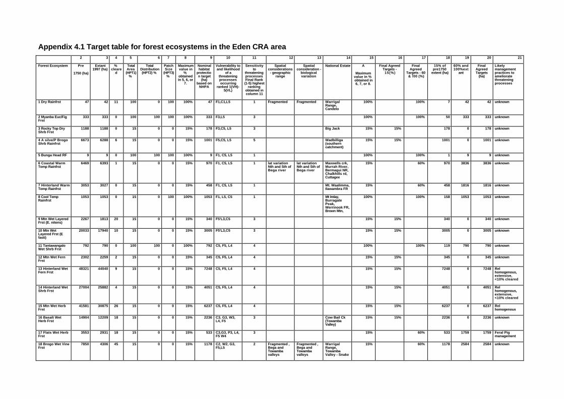
Appendix 4.1 Target table for forest ecosystems in the Eden CRA area2 3 4 5 6 7 8 9 10 11 12 13 14 15 16 17 18 19 20 21
Forest Ecosystem Pre
1750 (ha)
Extant1997 (ha)
%cleare
d
TotalArea
(HPT1)%
TotalDistribution(HPT2) %
PatchSize
(HPT3)%
Maximumvalue in
%obtainedin 5, 6, or
7.
Nominalhabitat
protection target
(ha)based on
NHPA
Vulnerability toand likelihood
of athreateningprocessesoccurring
ranked 1(VH)-5(VL)
Sensitivityto
threateningprocessesFinal Rank
(1-5) highestranking
obtained incolumn 11
Spatialconsiderations
- geographicrange
Spatialconsideration -
biologicalvariation
National Estate A
Maximumvalue in %obtained in6, 7, or 8.
Final AgreedTargets -
15(%)
FinalAgreed
Targets - 60& !00 (%)
15% ofpre1750
extent (ha)
60% and100%ext
ant
FinalAgreedTargets
(ha)
Likelymanagementpractices toamelioratethreateningprocesses
1 Dry Rainfrst 47 42 11 100 0 100 100% 47 F1,C1,L5 1 Fragmented Fragmented WarrigalRange,Candelo
100% 100% 7 42 42 unknown
2 Myanba Euc/FigFrst
333 333 0 100 100 100 100% 333 F3,L5 3 100% 100% 50 333 333 unknown
3 Rocky Top DryShrb Frst
1188 1188 0 15 0 0 15% 178 F3,C5, L5 3 Big Jack 15% 15% 178 0 178 unknown
4 A silve/P BrogoShrb Rainfrst
6673 6288 6 15 0 0 15% 1001 F5,C5, L5 5 Wadbilliga(southerncatchment)
15% 15% 1001 0 1001 unknown
5 Bunga Head RF 9 9 0 100 100 100 100% 9 F1, C5, L5 1 100% 100% 1 9 9 unknown
6 Coastal WarmTemp Rainfrst
6469 6393 1 15 0 0 15% 970 F1, C5, L5 1 lat variationNth and Sth ofBega river
lat variationNth and Sth ofBega river
Maxwells crk,Murrah River,Bermagui NR,Chalkhills rd,Cuttagee
15% 60% 970 3836 3836 unknown
7 Hinterland WarmTemp Rainfrst
3053 3027 0 15 0 0 15% 458 F1, C5, L5 1 Mt. Waalimma,Ilawambra FR
15% 60% 458 1816 1816 unknown
8 Cool TempRainfrst
1053 1053 0 15 0 100 100% 1053 F1, L5, C5 1 Mt Imlay,BurragatePeak,Werrinook FR,Brown Mtn,
100% 100% 158 1053 1053 unknown
9 Mtn Wet LayeredFrst (E. nitens)
2267 1813 20 15 0 0 15% 340 F5'L3,C5 3 15% 15% 340 0 340 unknown
10 Mtn WetLayered Frst (Efasti)
20033 17940 10 15 0 0 15% 3005 F5'L3,C5 3 15% 15% 3005 0 3005 unknown
11 TantawangaloWet Shrb Frst
792 790 0 100 100 0 100% 792 C5, F5, L4 4 100% 100% 119 790 790 unknown
12 Mtn Wet FernFrst
2302 2259 2 15 0 0 15% 345 C5, F5, L4 4 15% 15% 345 0 345 unknown
13 Hinterland WetFern Frst
48321 44040 9 15 0 0 15% 7248 C5, F5, L4 4 15% 15% 7248 0 7248 Relhomogenous,extensive,<10% cleared
14 Hinterland WetShrb Frst
27004 25882 4 15 0 0 15% 4051 C5, F5, L4 4 15% 15% 4051 0 4051 Relhomogenous,extensive,<10% cleared
15 Mtn Wet HerbFrst
41581 30875 26 15 0 0 15% 6237 C5, F5, L4 4 15% 15% 6237 0 6237 Relhomogenous
16 Basalt WetHerb Frst
14904 12209 18 15 0 0 15% 2236 C3, G3, W3,L4, F5
3 Cow Bail Ck(TowambaValley)
15% 15% 2236 0 2236 unknown
17 Flats Wet HerbFrst
3553 2931 18 15 0 0 15% 533 C3,G3, P3, L4,F5 W4
3 15% 60% 533 1759 1759 Feral Pigmanagement
18 Brogo Wet VineFrst
7850 4306 45 15 0 0 15% 1178 C2, W2, G3,F5,L5
2 Fragmented ,Bega andTowambavalleys
Fragmented ,Bega andTowambavalleys
WarrigalRange,TowambaValley - Snake
15% 60% 1178 2584 2584 unknown
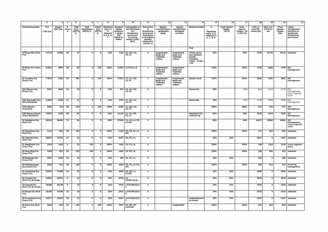
2 3 4 5 6 7 8 9 10 11 12 13 14 15 16 17 18 19 20 21
Forest Ecosystem Pre
1750 (ha)
Extant1997 (ha)
%cleare
d
TotalArea
(HPT1)%
TotalDistribution(HPT2) %
PatchSize
(HPT3)%
Maximumvalue in
%obtainedin 5, 6, or
7.
Nominalhabitat
protection target
(ha)based on
NHPA
Vulnerability toand likelihood
of athreateningprocessesoccurring
ranked 1(VH)-5(VL)
Sensitivityto
threateningprocessesFinal Rank
(1-5) highestranking
obtained incolumn 11
Spatialconsiderations
- geographicrange
Spatialconsideration -
biologicalvariation
National Estate A
Maximumvalue in %obtained in6, 7, or 8.
Final AgreedTargets -
15(%)
FinalAgreed
Targets - 60& !00 (%)
15% ofpre1750
extent (ha)
60% and100%ext
ant
FinalAgreedTargets
(ha)
Likelymanagementpractices toamelioratethreateningprocesses
Trail
19 Bega Wet ShrbFrst
47749 16908 65 15 0 0 15% 7162 C2, W2, G3,F5, L5
2 Fragmented ,Bega andTowambavalleys
Fragmented ,Bega andTowambavalleys
Yellow pinchdam (lowlandbasalt)TowambaValley - SnakeTrail
15% 60% 7162 10145 10145 unknown
20 Bega Dry GrassFrst
31952 3809 88 60 0 100 100% 31952 C1,F5,G1,L5 1 Fragmented ,Bega andTowambavalleys
Fragmented ,Bega andTowambavalleys
100% 100% 4793 3809 4793 Relhomogenous
21 Candelo DryGrass Frst
17873 1463 92 100 0 100 100% 17873 C1, G1, W2,L5, F5
1 Fragmented ,Bega andTowambavalleys
Fragmented ,Bega andTowambavalleys
Sandy Creek 100% 100% 2681 1463 2681 Relhomogenous
22A Monaro DryGrass Frst
5427 3625 33 15 0 0 15% 814 C2, G2, W2,L5, F5
2 Numurella 15% 60% 814 2175 2175 Relhomogenous,cross regionalissue
22B Numeralla DryShrb Woodland
11893 8248 31 15 0 0 15% 1784 C1, W1, G1,L5, F5
1 Numurella 15% 60% 1784 4949 4949 Relhomogenous
*23A MonaroGrassland
6481 334 95 100 0 100 100% 6481 C1, W1, G1,L5, F5
1 100% 100% 972 334 972 Relhomogenous
23B Monaro BasaltGrass Woodland
23567 3406 86 60 0 0 60% 14140 C1, G1, W1,F5, L4
1 Nimitibell VCL,Cathcart tip
60% 60% 3535 2044 3535 Relhomogenous
24 Subalpine DryShrb Frst
95154 26604 72 60 0 0 60% 57092 C4, G4, L4, F5,L4 W5
3 60% 60% 14273 15962 15962 Relhomogenous,cross regionalissue
25 Sandstone DryShrb Frst
1142 822 28 100 0 0 100% 1142 C5, G5, F5, L4W5
4 100% 100% 171 822 822 unknown
26 Tableland DryShrb Frst
28047 16115 43 15 0 0 15% 4207 C5, F5, L4, 4 15% 15% 4207 0 4207 unknown
27 Waalimma DryGrass Frst
1324 1324 0 15 100 0 100% 1324 C5, F5, L4, 4 100% 100% 199 1324 1324 cross regionalissue
28 Wog Wog DryGrass Frst
1304 922 29 100 100 0 100% 1304 C5, F5, L4, 4 100% 100% 196 922 922 unknown
29 Nalbaugh DryGrass Frst
2597 1936 25 15 0 0 15% 390 C5, F5, L4, 4 15% 15% 390 0 390 unknown
30 WallagaraughDry Grass Frst
1663 914 45 100 0 0 100% 1663 C5, F5, L4, P3,W3
3 100% 100% 249 914 914 Feral Pigmanagement
31 Hinterland DryGrass Frst
32925 27586 16 15 0 0 15% 4939 C5, G5, L4F5,W5
4 15% 15% 4939 0 4939 unknown
32 Coastal DryShrb Frst (E.longi)
24521 23401 5 15 0 0 15% 3678 L4,F5,W5,C5,G5
4 15% 15% 3678 0 3678 unknown
33 Coastal DryShrb Frst (E.muell)
16298 16136 0 15 0 0 15% 2445 L4,F5,W5,G5,C5
4 15% 15% 2445 0 2445 unknown
34 Brogo Dry ShrbFrst
16155 14155 12 15 0 0 15% 2423 L4,F5,W5,G5,C5
4 15% 15% 2423 0 2423 unknown
35 Escarpment DryGrass Frst
34577 22007 36 15 0 0 15% 5187 L4,F5,W5,G5,C5
4 lowland forestson basalt
15% 15% 5187 0 5187 unknown
36 Dune Dry ShrbFrst
1023 604 41 100 0 100 100% 1023 C2, W2, D1L4,F5,G4
1 Fragmented 100% 100% 153 604 604 unknown
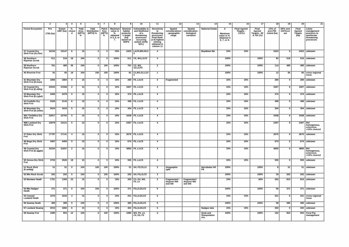
2 3 4 5 6 7 8 9 10 11 12 13 14 15 16 17 18 19 20 21
Forest Ecosystem Pre
1750 (ha)
Extant1997 (ha)
%cleare
d
TotalArea
(HPT1)%
TotalDistribution(HPT2) %
PatchSize
(HPT3)%
Maximumvalue in
%obtainedin 5, 6, or
7.
Nominalhabitat
protection target
(ha)based on
NHPA
Vulnerability toand likelihood
of athreateningprocessesoccurring
ranked 1(VH)-5(VL)
Sensitivityto
threateningprocessesFinal Rank
(1-5) highestranking
obtained incolumn 11
Spatialconsiderations
- geographicrange
Spatialconsideration -
biologicalvariation
National Estate A
Maximumvalue in %obtained in6, 7, or 8.
Final AgreedTargets -
15(%)
FinalAgreed
Targets - 60& !00 (%)
15% ofpre1750
extent (ha)
60% and100%ext
ant
FinalAgreedTargets
(ha)
Likelymanagementpractices toamelioratethreateningprocesses
37 Coastal DryShrb Frst (An.flor)
16153 15147 6 15 0 0 15% 2423 L4,F5,W5,G5,C5
4 Boydtown flat 15% 15% 2423 0 2423 unknown
38 SouthernRiparian Scrub
611 516 16 100 0 0 100% 611 C5, W4,L5,F5 4 100% 100% 92 516 516 unknown
39 NorthernRiparian Scrub
761 485 36 100 0 100 100% 761 C2, W2,G2,L5,F5
2 100% 100% 114 485 485 unknown
40 Riverine Frst 81 65 19 100 100 100 100% 81 C1,W1,G1,L5,F5
1 100% 100% 12 65 65 cross regionalissue
41 Mountain DryShrb Frst (E.fraxi)
1865 1864 0 15 0 0 15% 280 F5, L4,C5 4 Fragmented 15% 15% 280 0 280 unknown
42 Coastal DryShrb Frst (E.obliq)
22044 21556 2 15 0 0 15% 3307 F5, L4,C5 4 15% 15% 3307 0 3307 unknown
43 Mountain DryShrb Frst (E.cypel)
2492 2479 0 15 0 0 15% 374 F5, L4,C5 4 15% 15% 374 0 374 unknown
44 Foothills DryShrb Frst
3326 3142 6 15 0 0 15% 499 F5, L4,C5 4 15% 15% 499 0 499 unknown
45 Mountain DryShrb Frst (E.siebe)
2024 1915 5 15 0 0 15% 304 F5, L4,C5 4 15% 15% 304 0 304 unknown
46A Timbillica DryShrb Frst
22917 22792 0 15 0 0 15% 3438 F5, L4,C5 4 15% 15% 3438 0 3438 unknown
46B Lowland DryShrb Frst
15978 15121 5 15 0 0 15% 2397 F5, L4,C5 4 15% 15% 2397 0 2397 Relhomogenous,extensive,<10% cleared
47 Eden Dry ShrbFrst
17797 17141 4 15 0 0 15% 2670 F5, L4,C5 4 15% 15% 2670 0 2670 unknown
48 Bega Dry ShrbFrst
4497 4455 0 15 0 0 15% 674 F5, L4,C5 4 15% 15% 674 0 674 unknown
49 Coastal DryShrb Frst (E.agglo)
32334 31837 2 15 0 0 15% 4850 F5, L4,C5 4 15% 15% 4850 0 4850 Relhomogenous,extensive,<10% cleared
50 Genoa Dry ShrbFrst
3702 3026 18 15 0 0 15% 555 F5, L4,C5 4 15% 15% 555 0 555 unknown
51 Rock Shrb(K.ambig)
51 51 0 100 100 100 100% 51 G4, F3,C5,L5 3 Geographicsplit
Narrababa hillFR
100% 100% 8 51 51 unknown
52 Mtn Rock Scrub 202 202 0 100 0 100 100% 202 G4, F3,L5,C5 3 100% 100% 30 202 202 unknown
53 Montane Heath 1751 1350 23 15 0 0 15% 263 C3, G4, W4,F5, L5
3 Fragmented /disjunct Nthand Sth
Fragmented /disjunct Nthand Sth
15% 60% 263 810 810 unknown
54 Mtn NadgeeHeath
371 371 0 100 100 0 100% 371 F5,L5,G5,C5 5 100% 100% 56 371 371 unknown
55 CoastalLowland Heath
1676 1630 3 15 0 0 15% 251 F5,L5,G5,C5 5 15% 15% 251 0 251 cross regionalissue
56 Swamp Heath 385 385 0 100 0 0 100% 385 F5,L5,G5,C5 5 100% 100% 58 385 385 unknown
57 Lowland Swamp 2010 1892 6 15 0 0 15% 302 F5,L5,G5,C5 5 Nadgee lake 15% 15% 302 0 302 unknown
58 Swamp Frst 1080 953 12 100 0 100 100% 1080 W3, P3, L5,C4, G5, F5
3 Snob andSheepstationcks
100% 100% 162 953 953 Feral Pigmanagement
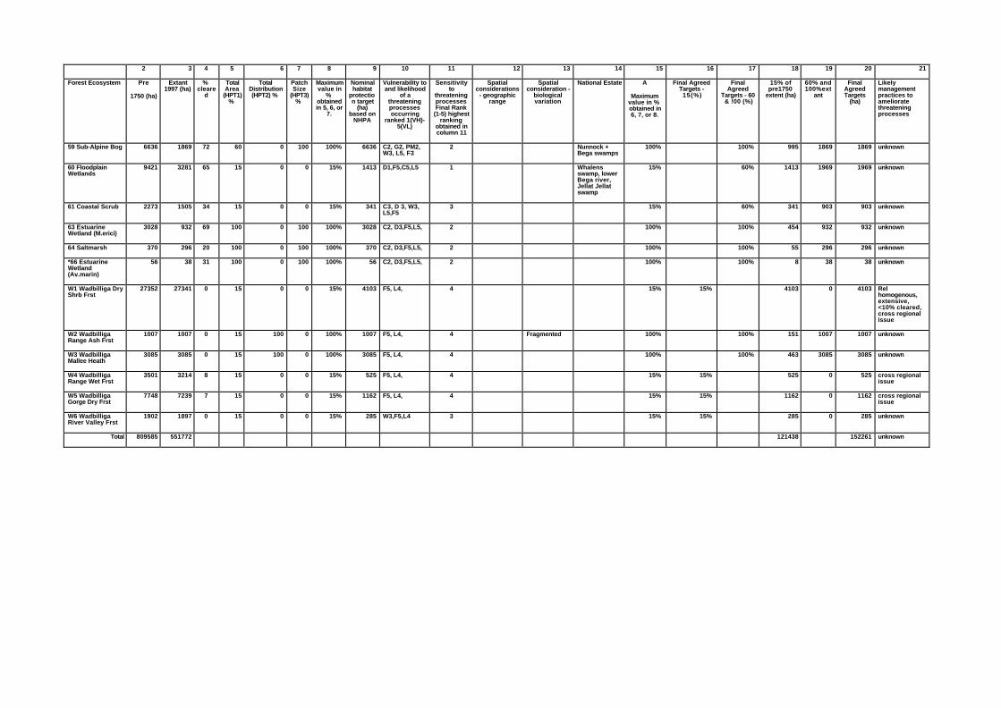
2 3 4 5 6 7 8 9 10 11 12 13 14 15 16 17 18 19 20 21
Forest Ecosystem Pre
1750 (ha)
Extant1997 (ha)
%cleare
d
TotalArea
(HPT1)%
TotalDistribution(HPT2) %
PatchSize
(HPT3)%
Maximumvalue in
%obtainedin 5, 6, or
7.
Nominalhabitat
protection target
(ha)based on
NHPA
Vulnerability toand likelihood
of athreateningprocessesoccurring
ranked 1(VH)-5(VL)
Sensitivityto
threateningprocessesFinal Rank
(1-5) highestranking
obtained incolumn 11
Spatialconsiderations
- geographicrange
Spatialconsideration -
biologicalvariation
National Estate A
Maximumvalue in %obtained in6, 7, or 8.
Final AgreedTargets -
15(%)
FinalAgreed
Targets - 60& !00 (%)
15% ofpre1750
extent (ha)
60% and100%ext
ant
FinalAgreedTargets
(ha)
Likelymanagementpractices toamelioratethreateningprocesses
59 Sub-Alpine Bog 6636 1869 72 60 0 100 100% 6636 C2, G2, PM2,W3, L5, F3
2 Nunnock +Bega swamps
100% 100% 995 1869 1869 unknown
60 FloodplainWetlands
9421 3281 65 15 0 0 15% 1413 D1,F5,C5,L5 1 Whalensswamp, lowerBega river,Jellat Jellatswamp
15% 60% 1413 1969 1969 unknown
61 Coastal Scrub 2273 1505 34 15 0 0 15% 341 C3, D 3, W3,L5,F5
3 15% 60% 341 903 903 unknown
63 EstuarineWetland (M.erici)
3028 932 69 100 0 100 100% 3028 C2, D3,F5,L5, 2 100% 100% 454 932 932 unknown
64 Saltmarsh 370 296 20 100 0 100 100% 370 C2, D3,F5,L5, 2 100% 100% 55 296 296 unknown
*66 EstuarineWetland(Av.marin)
56 38 31 100 0 100 100% 56 C2, D3,F5,L5, 2 100% 100% 8 38 38 unknown
W1 Wadbilliga DryShrb Frst
27352 27341 0 15 0 0 15% 4103 F5, L4, 4 15% 15% 4103 0 4103 Relhomogenous,extensive,<10% cleared,cross regionalissue
W2 WadbilligaRange Ash Frst
1007 1007 0 15 100 0 100% 1007 F5, L4, 4 Fragmented 100% 100% 151 1007 1007 unknown
W3 WadbilligaMallee Heath
3085 3085 0 15 100 0 100% 3085 F5, L4, 4 100% 100% 463 3085 3085 unknown
W4 WadbilligaRange Wet Frst
3501 3214 8 15 0 0 15% 525 F5, L4, 4 15% 15% 525 0 525 cross regionalissue
W5 WadbilligaGorge Dry Frst
7748 7239 7 15 0 0 15% 1162 F5, L4, 4 15% 15% 1162 0 1162 cross regionalissue
W6 WadbilligaRiver Valley Frst
1902 1897 0 15 0 0 15% 285 W3,F5,L4 3 15% 15% 285 0 285 unknown
Total 809585 551772 121438 152261 unknown

JANIS and Natural National Estate Conservation Requirements for the Eden Region
55
Appendix 4. 2 - Minutes of the forest ecosystem workshop on target setting forconservation requirements
Friday 19/9/97
Head Office NPWS
Those in Attendance: Doug Binns (SF), David Keith (NPWS), Phil Gilmore (Independent), Karl Bossard(EA), Geoff Moore (NPWS Convenor), Helen Neave (EA observer), Bronwyn Goody (EA observer) andHelen Achurch (NPWS Minutes).
1. Introduction and addition to agenda items
Suggested changes to forest ecosystem guiding principles document
n clarification of table in task 6 of 3.1.3 of the supporting documentation for forest ecosystems so that itreads: ‘Endangered is when total area has contracted to less than 10% of its former range; vulnerableecosystems are those where total area is reduced to 11-30% of their former area; and ‘other’ areecosystems which cover greater than 30% of their former area’;
n Formula in task 10 of 3.1.3 be amended to read:
NHPA1(ha)= Pre-1750 FE*maximum(HPT1, HPT2 or HPT3)/100.
Addition of cross-regional considerations to the Agenda.
2. Review of targets based on total area, and setting of targets, based on distribution and patchsize
Experts reviewed each vegetation type and checked HPT1 target that was derived prior to the workshop.
Expert knowledge was used to assign targets (HPT2 and HPT3). Each forest ecosystem type wasconsidered in terms of distribution and patch size. Using the rule set contained in the supportingdocumentation, targets HPT2 and HPT3 were assigned where appropriate. (The expert panel considered allvegetation types and assigned targets of 100% to those vegetation types meeting the categories set out in therule set)
Discussion of each vegetation type is summarised in Table 1.
It was noted that SFNSW had not yet supported the use of vegetation types as ‘forest ecosystems’ to assessJANIS targets. The workshop recommended that if decisions were taken to reduce the number of forestecosystems by merging vegetation types, targets should be assessed as demonstrated in the followingexample.
In the case of vegetation types 28 and 31 which are floristically similar but have differing targets. If these areto be merged, the expert panel recommended that the target assigned to the more extensive type also beassigned to the less extensive type. This would then ensure that the less extensive vegetation type is stillreserved at least to the level of 15%, thereby also ensuring that heterogeneity within broader merged units isrepresented in reserves (JANIS).
3. Ranking of forest ecosystem vulnerability 1(highest)-5(lowest)
Determination of a vulnerability ranking was broken down in the following way:
n determine major threatening processes likely to affect the forest ecosystem in the study area;
n group forest ecosystem types which experience a similar level of vulnerability to a threatening process;
n apply a ranking of vulnerability to each of the major threatening processes for each forest ecosystem;
n determine overall vulnerability ranking by taking the highest ranking from any of the threatening processes.
JANIS and Natural National Estate Conservation Requirements
56
The main threatening processes were: inappropriate fire regimes (F), logging (L), clearing (C), grazing (G),weeds (W), feral pigs (P) and habitat degradation (D). (Disease was not considered a likely threat in thestudy area).
Generalities that were agreed to so that forest ecosystems with similar vulnerabilities to certain threateningprocesses could be grouped:
Fire :
n Eucalyptus dominated ecosystems were given a ranking of 1 for vulnerability to fire. Rainforest forestecosystem types 1,5,6,7 and 8 were given a ranking of 5 due to the higher vulnerability due to rainforestspecies. Forest ecosystems 2 and 3 were given a ranking of 3 due to the vulnerability of some rainforestspecies in their ecosystem;
n Heath ecosystems were given a ranking of 3 - the panel felt that fire could be a problem when combinedwith variable weather conditions;
n Swamps and bogs were given a ranking of 3 - rare, but extreme fire events would lead to habitatdegradation through peat consumption.
Logging:
n Non-eucalypt species given a ranking of 1 because of low logging pressures;
n Dry Euc forests receive a ranking of 2;
n Wet Euc. forests receive a ranking of 3 (because of the adverse competitive effect of a dense fernunderstorey on regenerating seedlings of trees and shrubs > vulnerability);
n Exceptions to this; forest ecosystem types 11,12,14, 15, and 16, were ranked as 2 because they do nothave dense fern understorey.
Clearing:
The panel decided that clearing was a threatening process occurring mainly on private land. Therefore landtenure was important when considering the vulnerability of FE’s to this threatening process. Ranking forclearing was assigned on an ecosystem by ecosystem basis.
Weeds:
Considered on an ecosystem by ecosystem basis.
Grazing:
Considered on an ecosystem by ecosystem basis.
Degradation:
Considered on an ecosystem by ecosystem basis.
Feral Pigs:
Considered on an ecosystem by ecosystem basis with emphasis on ecosystems occurring on flats assumed tobe the most vulnerable.
Each forest ecosystem type was then assigned a final ranking based on the highest ranking received for anyof the threatening processes. For the vulnerable grouping of forest ecosystems (ie those whose pre-1750extent has been depleted to 11-30%, HBT1 = 60%) where they received an overall vulnerable ranking of 1 or2, the target was adjusted up to 80% or 100% respectively. (This only occurred in one case).
4. Spatial considerations
The panel determined spatial considerations enabling forest ecosystems to be adequately replicated acrosstheir geographic range and for the full range of biological variation to be sampled.
JANIS and Natural National Estate Conservation Requirements for the Eden Region
57
Forest ecosystem types 1, 18 -21 need to be sampled from both the Bega and Towamba valleys. Forestecosystem types in these two areas have been fragmented so some proportion of the target should be metfrom each of the remaining fragments. It was suggested that original hectares of each forest type in each ofthe two areas be calculated and then target sought proportionally. The outcome then is reviewed by theexpert panel.
Forest ecosystem type 53 is also fragmented into north and south segments. As above, target should besought proportionally from each area.
Forest ecosystem type 6 has some latitudinal variations so, as above, target should be sought from north andsouth of the Bega River.
Forest ecosystem type 51 has a geographic split in its range. Narabarba and Nullica. As above, seek targetin all areas.
If amalgamated veg types are to be used in negotiation then further spatial considerations should beconsidered.
5. National Estate
Some general rules for identifying the best (national estate) examples of forest ecosystems were outlined:
n all areas of rainforest > 20 hectares;
n all areas on rhyolite; and
n all areas on lowland basalt (Lochiel group).
The expert panel then recommended areas of various forest ecosystem types where national estate valueswould be high:
FE 1 - Warrigal Range, Candelo
FE 3 - Big Jack Mountain
FE 4 - Wadbilliga (southern catchments)
FE 5 - Bunga Head
FE 6 - Maxwells creek, Murrah River, Bermagui Nature Reserve and Chalk Hills Rd in Yurammie.
FE 7 - Waalmma Mt and Illawambra Forest Reserve
FE 8 - Mt Imlay, Brown Mt, Burragate Peak and Werrinook Forest Reserve
FE 16 - Cow Bail creek (head of Towamba valley)
FE 18 - Warrigal Range and Snake Trail (Towamba Valley)
FE 19 - Yellow Pinch Dam with E.teriticornis and Snake Trail (Towamba Valley)
FE 21 - Sandy Creek
FE 22B - Numeralla Crown Land
FE 23A - Nimitabel Vacant Crown Land and Cathcart Tip
FE 35 - Any lowland forests on basalt
FE 51 - Narabarba hill and surrounds
FE 57 - Nadgee Lake
FE 58 - Sheep Station Creek and Snob Creek
FE 59 - Nunnock Swamp and Bega Swamp (research site)
FE 60 - Whalens Swamp, lower Bega river wetlands and Jellat Jellat, Boyd Town Flats Vacant Crown Land
JANIS and Natural National Estate Conservation Requirements
58
Nalbaugh Plateau would conserve a range of forest ecosystem types.
The panel also advised that in addition to the above areas, the examples of each ecosystem type incorporatedinto the CAR reserve system would meet the national estate criteria relating to rare and representativeecosystems and plant communities.
6. Management practices to ameliorate threatening process.
Each forest ecosystem type was previously given a ranking for their vulnerability to various threateningprocesses. The panel suggested that this would be a good guide for determining management strategies.Detailed management prescriptions should be determined in the course of management planning with regardto strategies identified by workshop experts.
Forest ecosystem types 17, 30 and 58 - feral pig control was a necessary management practice.
7. Recommendations for prioritising targets
The panel suggested that the following criteria were appropriate for selecting forest ecosystem types, thatcould be identified as lower priority for meeting targets where conflicts preclude all targets being met:
n vegetation type is extensive and relatively homogeneous throughout its range and incurs low resource useand is resilient;
n vegetation type given a final ranking or 1 or 2 for vulnerability to threatening process (in previous tasks);
n vegetation type covers greater than 20000 hectares;
n vegetation type has been cleared less than 10% from pre-1750 coverage.
Based on these criteria, vegetation types 13, 14, 46A, 49 and 81 were flagged as lower priority targets.
8. Cross-regional issues
The panel noted that an extensive cross-regional analysis was required to identify with a high level ofcertainty, vegetation types with distributions extending over large areas outside the Eden CRA. Nonetheless,the panel flagged some forest ecosystems that occurred outside the Eden CRA region, with some degree ofcertainty that they are floristically similar to examples found within the Eden region. They were: 22A, 24, 27,40, 55, 65, 81, 84, and 85. These forest ecosystems require a closer examination of their extent andreservation status over the border before any adjustments are made to Eden targets. This could be importantfor forest ecosystems for which 100% targets were assigned. Subsequent investigation of vegetation studiescarried out in East Gippsland revealed that forest ecosystem 27 is likely to be very restricted there. The mostsimilar Ecological Vegetation Class (No.24) in East Gippsland has a structurally and floristically differentunderstorey and has a more restricted distribution than forest ecosystem 27 in NSW.
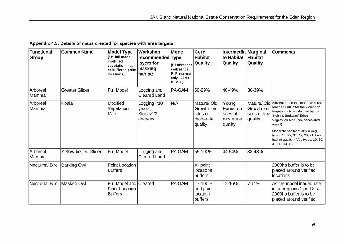
JANIS and Natural National Estate Conservation Requirements for the Eden Region
59
Appendix 4.3: Details of maps created for species with area targets
FunctionalGroup
Common Name Model Type(i.e. full model,modifiedvegetation mapor buffered pointlocations)
Workshoprecommendedlayers formaskinghabitat
ModelType
(PA=Presence-absence,P=Presenceonly, GAM= ,GLM = )
CoreHabitatQuality
Intermediate HabitatQuality
MarginalHabitatQuality
Comments
ArborealMammal
Greater Glider Full Model Logging andCleared Land
PA-GAM 50-99% 40-49% 30-39%
ArborealMammal
Koala ModifiedVegetationMap
Logging <10years,Slope>23degrees
N/A Mature/ OldGrowth onsites ofmoderatequality.
YoungForest onsites ofmoderatequality.
Mature/ OldGrowth onsites of lowquality.
Agreement on this model was notreached until after the workshop.Vegetation types defined by the“Keith & Bedward” EdenVegetation Map (see associatedreport).
Moderate habitat quality = Vegtypes: 14, 32, 34, 42, 20, 21. Lowhabitat quality = Veg types: 29. 30,31, 35, 43, 18.
ArborealMammal
Yellow-bellied Glider Full Model Logging andCleared Land
PA-GAM 55-100% 44-54% 33-43%
Nocturnal Bird Barking Owl Point LocationBuffers
All pointlocationsbuffers.
2000ha buffer is to beplaced around verifiedlocations.
Nocturnal Bird Masked Owl Full Model andPoint LocationBuffers
Cleared PA-GAM 17-100 %and pointlocationbuffers.
12-16% 7-11% As the model inadequatein subregions 1 and 8, a2000ha buffer is to beplaced around verified
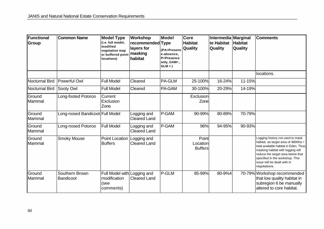
JANIS and Natural National Estate Conservation Requirements
60
FunctionalGroup
Common Name Model Type(i.e. full model,modifiedvegetation mapor buffered pointlocations)
Workshoprecommendedlayers formaskinghabitat
ModelType
(PA=Presence-absence,P=Presenceonly, GAM= ,GLM = )
CoreHabitatQuality
Intermediate HabitatQuality
MarginalHabitatQuality
Comments
locations.
Nocturnal Bird Powerful Owl Full Model Cleared PA-GLM 25-100% 16-24% 11-15%
Nocturnal Bird Sooty Owl Full Model Cleared PA-GAM 30-100% 20-29% 14-19%
GroundMammal
Long-footed Potoroo CurrentExclusionZone
ExclusionZone
GroundMammal
Long-nosed Bandicoot Full Model Logging andCleared Land
P-GAM 90-99% 80-89% 70-79%
GroundMammal
Long-nosed Potoroo Full Model Logging andCleared Land
P-GAM 96% 94-95% 90-93%
GroundMammal
Smoky Mouse Point LocationBuffers
Logging andCleared Land
PointLocationBuffers
Logging history not used to maskhabitat as target area of 4800ha =total available habitat in Eden. Thus,masking habitat with logging willreduce the target area below thatspecified in the workshop. Thisissue will be dealt with innegotiations.
GroundMammal
Southern BrownBandicoot
Full Model withmodification(seecomments)
Logging andCleared Land
P-GLM 95-99% 80-9%4 70-79% Workshop recommendedthat low quality habitat insubregion 6 be manuallyaltered to core habitat.
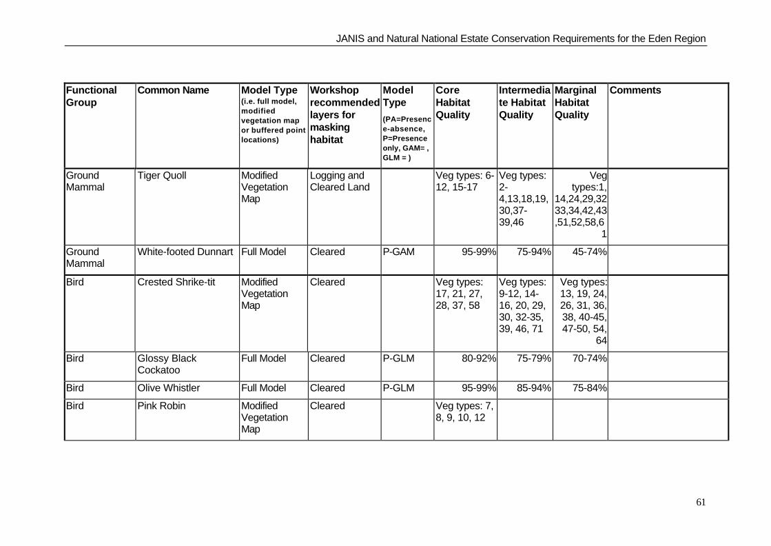
JANIS and Natural National Estate Conservation Requirements for the Eden Region
61
FunctionalGroup
Common Name Model Type(i.e. full model,modifiedvegetation mapor buffered pointlocations)
Workshoprecommendedlayers formaskinghabitat
ModelType
(PA=Presence-absence,P=Presenceonly, GAM= ,GLM = )
CoreHabitatQuality
Intermediate HabitatQuality
MarginalHabitatQuality
Comments
GroundMammal
Tiger Quoll ModifiedVegetationMap
Logging andCleared Land
Veg types: 6-12, 15-17
Veg types:2-4,13,18,19,30,37-39,46
Vegtypes:1,
14,24,29,3233,34,42,43,51,52,58,6
1
GroundMammal
White-footed Dunnart Full Model Cleared P-GAM 95-99% 75-94% 45-74%
Bird Crested Shrike-tit ModifiedVegetationMap
Cleared Veg types:17, 21, 27,28, 37, 58
Veg types:9-12, 14-16, 20, 29,30, 32-35,39, 46, 71
Veg types:13, 19, 24,26, 31, 36,38, 40-45,47-50, 54,
64
Bird Glossy BlackCockatoo
Full Model Cleared P-GLM 80-92% 75-79% 70-74%
Bird Olive Whistler Full Model Cleared P-GLM 95-99% 85-94% 75-84%
Bird Pink Robin ModifiedVegetationMap
Cleared Veg types: 7,8, 9, 10, 12
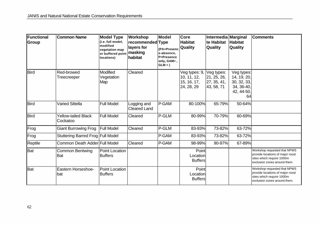
JANIS and Natural National Estate Conservation Requirements
62
FunctionalGroup
Common Name Model Type(i.e. full model,modifiedvegetation mapor buffered pointlocations)
Workshoprecommendedlayers formaskinghabitat
ModelType
(PA=Presence-absence,P=Presenceonly, GAM= ,GLM = )
CoreHabitatQuality
Intermediate HabitatQuality
MarginalHabitatQuality
Comments
Bird Red-browedTreecreeper
ModifiedVegetationMap
Cleared Veg types: 9,10, 11, 12,15, 16, 17,24, 28, 29
Veg types:21, 25, 26,27, 35, 41,43, 58, 71
Veg types:14, 19, 20,30, 32, 33,34, 36-40,42, 44-50,
64
Bird Varied Sittella Full Model Logging andCleared Land
P-GAM 80-100% 65-79% 50-64%
Bird Yellow-tailed BlackCockatoo
Full Model Cleared P-GLM 80-99% 70-79% 60-69%
Frog Giant Burrowing Frog Full Model Cleared P-GLM 83-93% 73-82% 63-72%
Frog Stuttering Barred Frog Full Model P-GAM 83-93% 73-82% 63-72%
Reptile Common Death Adder Full Model Cleared P-GAM 98-99% 90-97% 67-89%
Bat Common BentwingBat
Point LocationBuffers
PointLocationBuffers
Workshop requested that NPWSprovide locations of major roostsites which require 1000mexclusion zones around them.
Bat Eastern Horseshoe-bat
Point LocationBuffers
PointLocationBuffers
Workshop requested that NPWSprovide locations of major roostsites which require 1000mexclusion zones around them.

JANIS and Natural National Estate Conservation Requirements for the Eden Region
63
FunctionalGroup
Common Name Model Type(i.e. full model,modifiedvegetation mapor buffered pointlocations)
Workshoprecommendedlayers formaskinghabitat
ModelType
(PA=Presence-absence,P=Presenceonly, GAM= ,GLM = )
CoreHabitatQuality
Intermediate HabitatQuality
MarginalHabitatQuality
Comments
Bat Grey-headed FlyingFox
ModifiedVegetationMap
Logging andCleared Land
Veg types:18, 20, 21,32, 46, 47
Doug Mills, Brad Law and HarryParnaby discussed the veg basedmodel after the workshop andsuggested developing a modelbased on E. tereticonis,E.gummnifera and E.longifoliainstead. It was agreed that a targetof 4* 300ha patches per sub-region be set.
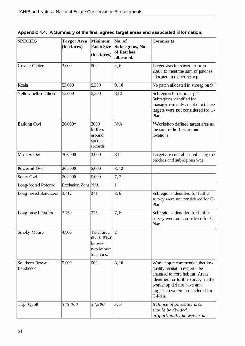
JANIS and Natural National Estate Conservation Requirements
64
Appendix 4.4: A Summary of the final agreed target areas and associated information.
SPECIES Target Area(hectares)
MinimumPatch Size
(hectares)
No. ofSubregions, No.of Patchesallocated.
Comments
Greater Glider 3,000 500 4, 6 Target was increased to from2,600 to meet the sum of patchesallocated in the workshop.
Koala 53,000 5,300 9, 10 No patch allocated in subregion 9.
Yellow-bellied Glider 53,000 5,300 8,10 Subregion 6 has no target.Subregions identified formanagement only and did not havetargets were not considered for C-Plan.
Barking Owl 26,000* 2000buffersaroundspeciesrecords.
N/A *Workshop defined target area asthe sum of buffers aroundlocations.
Masked Owl 308,000 3,000 8,11 Target area not allocated using thepatches and subregions was...
Powerful Owl 260,000 5,000 8, 12
Sooty Owl 204,000 5,000 7, 7
Long-footed Potoroo Exclusion Zone N/A 1
Long-nosed Bandicoot 3,412 341 8, 9 Subregions identified for furthersurvey were not considered for C-Plan.
Long-nosed Potoroo 3,750 375 7, 8 Subregions identified for furthersurvey were not considered for C-Plan.
Smoky Mouse 4,800 Total areadivide 60:40betweentwo knownlocations.
2
Southern BrownBandicoot
5,000 500 8, 10 Workshop recommended that lowquality habitat in region 6 bechanged to core habitat. Areasidentified for further survey in theworkshop did not have areatargets so weren’t considered forC-Plan.
Tiger Quoll 375,000 37,500 5, 5 Balance of allocated areashould be dividedproportionally between sub-
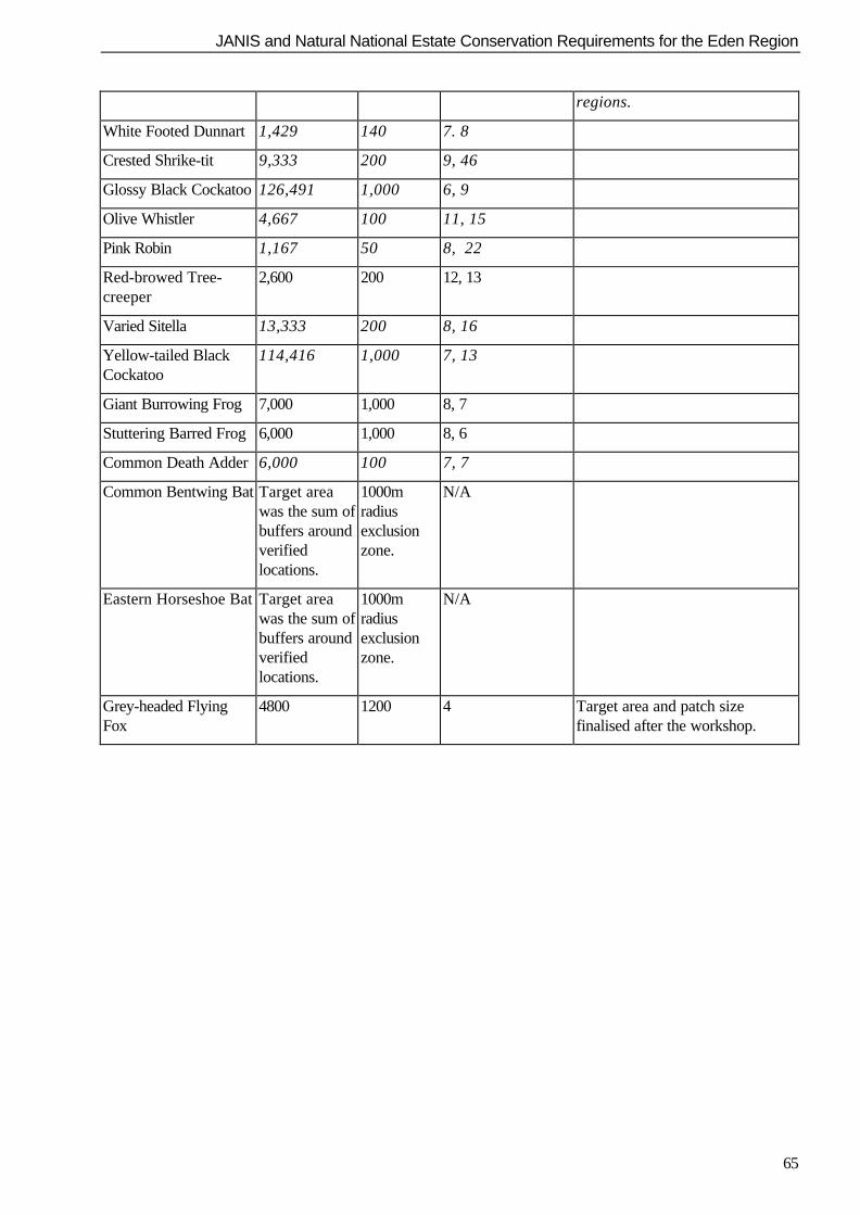
JANIS and Natural National Estate Conservation Requirements for the Eden Region
65
regions.
White Footed Dunnart 1,429 140 7. 8
Crested Shrike-tit 9,333 200 9, 46
Glossy Black Cockatoo 126,491 1,000 6, 9
Olive Whistler 4,667 100 11, 15
Pink Robin 1,167 50 8, 22
Red-browed Tree-creeper
2,600 200 12, 13
Varied Sitella 13,333 200 8, 16
Yellow-tailed BlackCockatoo
114,416 1,000 7, 13
Giant Burrowing Frog 7,000 1,000 8, 7
Stuttering Barred Frog 6,000 1,000 8, 6
Common Death Adder 6,000 100 7, 7
Common Bentwing Bat Target areawas the sum ofbuffers aroundverifiedlocations.
1000mradiusexclusionzone.
N/A
Eastern Horseshoe Bat Target areawas the sum ofbuffers aroundverifiedlocations.
1000mradiusexclusionzone.
N/A
Grey-headed FlyingFox
4800 1200 4 Target area and patch sizefinalised after the workshop.

JANIS and Natural National Estate Conservation Requirements
66
Appendix 4.5 - Habitat models and sub-region maps

JANIS and Natural National Estate Conservation Requirements for the Eden Region
67

JANIS and Natural National Estate Conservation Requirements
68

JANIS and Natural National Estate Conservation Requirements for the Eden Region
69

JANIS and Natural National Estate Conservation Requirements
70

JANIS and Natural National Estate Conservation Requirements for the Eden Region
71

JANIS and Natural National Estate Conservation Requirements
72

JANIS and Natural National Estate Conservation Requirements for the Eden Region
73

JANIS and Natural National Estate Conservation Requirements
74

JANIS and Natural National Estate Conservation Requirements for the Eden Region
75

JANIS and Natural National Estate Conservation Requirements
76

JANIS and Natural National Estate Conservation Requirements for the Eden Region
77

JANIS and Natural National Estate Conservation Requirements
78

JANIS and Natural National Estate Conservation Requirements for the Eden Region
79

JANIS and Natural National Estate Conservation Requirements
80

JANIS and Natural National Estate Conservation Requirements for the Eden Region
81

JANIS and Natural National Estate Conservation Requirements
82

JANIS and Natural National Estate Conservation Requirements for the Eden Region
83

JANIS and Natural National Estate Conservation Requirements
84

JANIS and Natural National Estate Conservation Requirements for the Eden Region
85

JANIS and Natural National Estate Conservation Requirements
86

JANIS and Natural National Estate Conservation Requirements for the Eden Region
87

JANIS and Natural National Estate Conservation Requirements
88

JANIS and Natural National Estate Conservation Requirements for the Eden Region
89

JANIS and Natural National Estate Conservation Requirements
90

JANIS and Natural National Estate Conservation Requirements for the Eden Region
91

JANIS and Natural National Estate Conservation Requirements
92

JANIS and Natural National Estate Conservation Requirements for the Eden Region
93

JANIS and Natural National Estate Conservation Requirements
94

JANIS and Natural National Estate Conservation Requirements for the Eden Region
95

JANIS and Natural National Estate Conservation Requirements
96

JANIS and Natural National Estate Conservation Requirements for the Eden Region
97

JANIS and Natural National Estate Conservation Requirements
98

JANIS and Natural National Estate Conservation Requirements for the Eden Region
99

JANIS and Natural National Estate Conservation Requirements
100

JANIS and Natural National Estate Conservation Requirements for the Eden Region
101

JANIS and Natural National Estate Conservation Requirements
102

JANIS and Natural National Estate Conservation Requirements for the Eden Region
103

JANIS and Natural National Estate Conservation Requirements
104

JANIS and Natural National Estate Conservation Requirements for the Eden Region
105

JANIS and Natural National Estate Conservation Requirements
106

JANIS and Natural National Estate Conservation Requirements for the Eden Region
107

JANIS and Natural National Estate Conservation Requirements
108

JANIS and Natural National Estate Conservation Requirements for the Eden Region
109

JANIS and Natural National Estate Conservation Requirements
110

JANIS and Natural National Estate Conservation Requirements for the Eden Region
111

JANIS and Natural National Estate Conservation Requirements
112

JANIS and Natural National Estate Conservation Requirements for the Eden Region
113

JANIS and Natural National Estate Conservation Requirements
114

JANIS and Natural National Estate Conservation Requirements for the Eden Region
115

JANIS and Natural National Estate Conservation Requirements
116

JANIS and Natural National Estate Conservation Requirements for the Eden Region
117

JANIS and Natural National Estate Conservation Requirements
118

JANIS and Natural National Estate Conservation Requirements for the Eden Region
119

JANIS and Natural National Estate Conservation Requirements
120

JANIS and Natural National Estate Conservation Requirements for the Eden Region
121

JANIS and Natural National Estate Conservation Requirements
122
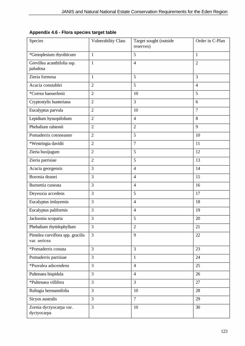
JANIS and Natural National Estate Conservation Requirements for the Eden Region
123
Appendix 4.6 - Flora species target table
Species Vulnerability Class Target sought (outsidereserves)
Order in C-Plan
*Genoplesium rhyoliticum 1 5 1
Grevillea acanthifolia ssp.paludosa
1 4 2
Zieria formosa 1 5 3
Acacia constablei 2 5 4
*Correa baeuerlenii 2 10 5
Cryptostylis hunteriana 2 3 6
Eucalyptus parvula 2 10 7
Lepidium hyssopifolium 2 4 8
Phebalium ralstonii 2 2 9
Pomaderris cotoneaster 2 5 10
*Westringia davidii 2 7 11
Zieria buxijugum 2 5 12
Zieria parrisiae 2 5 13
Acacia georgensis 3 4 14
Boronia deanei 3 4 15
Burnettia cuneata 3 4 16
Deyeuxia accedens 3 5 17
Eucalyptus imlayensis 3 4 18
Eucalyptus paliformis 3 4 19
Jacksonia scoparia 3 5 20
Phebalium rhytidophyllum 3 2 21
Pimelea curviflora spp. gracilisvar. sericea
3 9 22
*Pomaderris costata 3 3 23
Pomaderris parrisiae 3 1 24
*Psoralea adscendens 3 4 25
Pultenaea hispidula 3 4 26
*Pultenaea villifera 3 3 27
Rulingia hermannifolia 3 10 28
Sicyos australis 3 7 29
Zornia dyctyocarpa var.dyctyocarpa
3 10 30
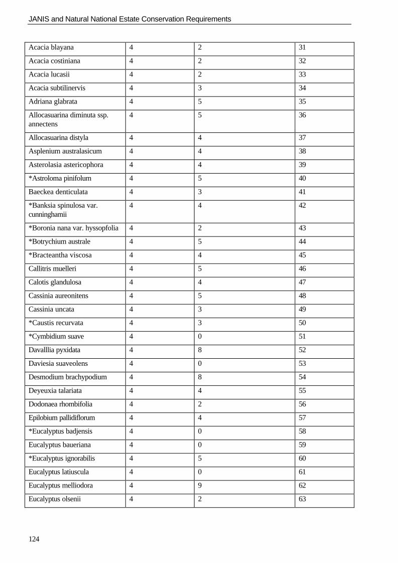
JANIS and Natural National Estate Conservation Requirements
124
Acacia blayana 4 2 31
Acacia costiniana 4 2 32
Acacia lucasii 4 2 33
Acacia subtilinervis 4 3 34
Adriana glabrata 4 5 35
Allocasuarina diminuta ssp.annectens
4 5 36
Allocasuarina distyla 4 4 37
Asplenium australasicum 4 4 38
Asterolasia astericophora 4 4 39
*Astroloma pinifolum 4 5 40
Baeckea denticulata 4 3 41
*Banksia spinulosa var.cunninghamii
4 4 42
*Boronia nana var. hyssopfolia 4 2 43
*Botrychium australe 4 5 44
*Bracteantha viscosa 4 4 45
Callitris muelleri 4 5 46
Calotis glandulosa 4 4 47
Cassinia aureonitens 4 5 48
Cassinia uncata 4 3 49
*Caustis recurvata 4 3 50
*Cymbidium suave 4 0 51
Davalllia pyxidata 4 8 52
Daviesia suaveolens 4 0 53
Desmodium brachypodium 4 8 54
Deyeuxia talariata 4 4 55
Dodonaea rhombifolia 4 2 56
Epilobium pallidiflorum 4 4 57
*Eucalyptus badjensis 4 0 58
Eucalyptus baueriana 4 0 59
*Eucalyptus ignorabilis 4 5 60
Eucalyptus latiuscula 4 0 61
Eucalyptus melliodora 4 9 62
Eucalyptus olsenii 4 2 63
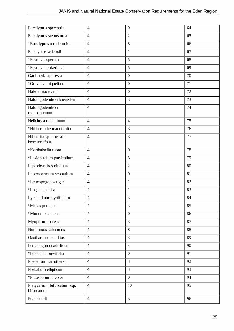
JANIS and Natural National Estate Conservation Requirements for the Eden Region
125
Eucalyptus spectatrix 4 0 64
Eucalyptus stenostoma 4 2 65
*Eucalyptus tereticornis 4 8 66
Eucalyptus wilcoxii 4 1 67
*Festuca asperula 4 5 68
*Festuca hookeriana 4 5 69
Gaultheria appressa 4 0 70
*Grevillea miqueliana 4 0 71
Hakea macreana 4 0 72
Haloragodendron baeuerlenii 4 3 73
Haloragodendronmonospermum
4 1 74
Helichrysum collinum 4 4 75
*Hibbertia hermanniifolia 4 3 76
Hibbertia sp. nov. aff.hermanniifolia
4 3 77
*Korthalsella rubra 4 9 78
*Lasiopetalum parvifolium 4 5 79
Leptorhynchos nitidulus 4 2 80
Leptospermum scoparium 4 0 81
*Leucopogon setiger 4 1 82
*Logania pusilla 4 1 83
Lycopodium myrtifolium 4 3 84
*Mazus pumilio 4 3 85
*Monotoca albens 4 0 86
Myoporum bateae 4 3 87
Notothixos subaurens 4 8 88
Ozothamnus conditus 4 3 89
Pentapogon quadrifidus 4 4 90
*Persoonia brevifolia 4 0 91
Phebalium carruthersii 4 3 92
Phebalium ellipticum 4 3 93
*Pittosporum bicolor 4 0 94
Platycerium bifurcatum ssp.bifurcatum
4 10 95
Poa cheelii 4 3 96
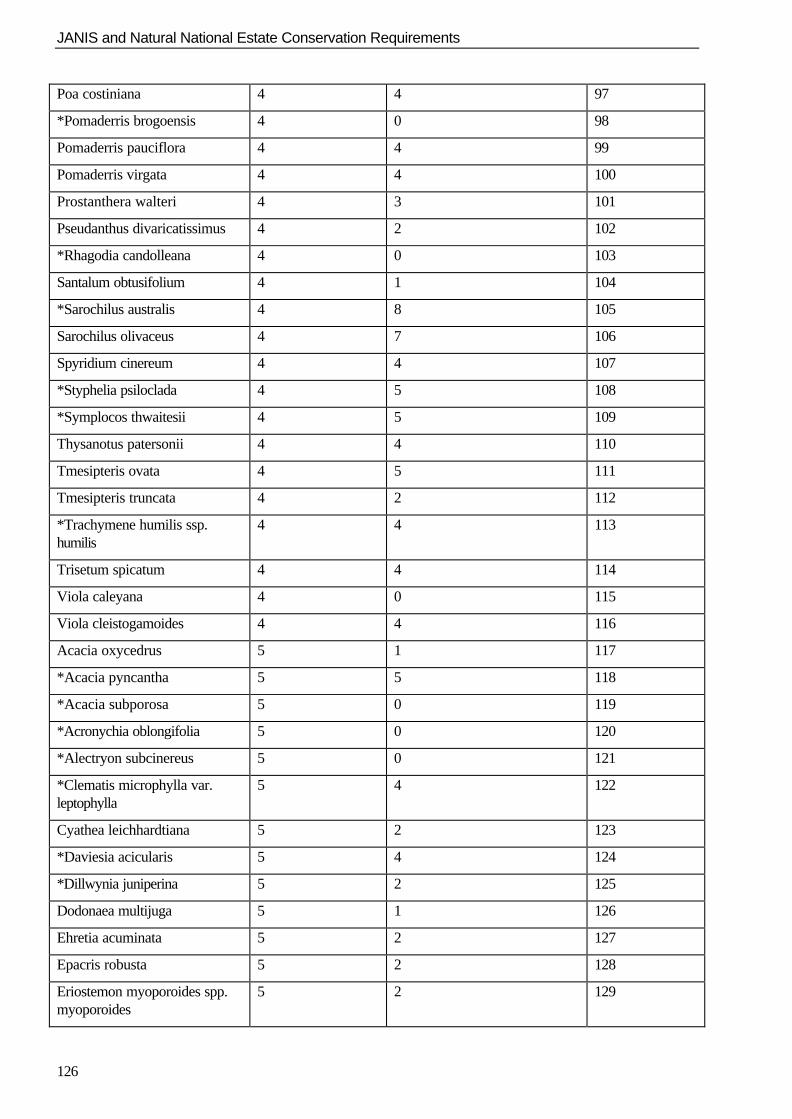
JANIS and Natural National Estate Conservation Requirements
126
Poa costiniana 4 4 97
*Pomaderris brogoensis 4 0 98
Pomaderris pauciflora 4 4 99
Pomaderris virgata 4 4 100
Prostanthera walteri 4 3 101
Pseudanthus divaricatissimus 4 2 102
*Rhagodia candolleana 4 0 103
Santalum obtusifolium 4 1 104
*Sarochilus australis 4 8 105
Sarochilus olivaceus 4 7 106
Spyridium cinereum 4 4 107
*Styphelia psiloclada 4 5 108
*Symplocos thwaitesii 4 5 109
Thysanotus patersonii 4 4 110
Tmesipteris ovata 4 5 111
Tmesipteris truncata 4 2 112
*Trachymene humilis ssp.humilis
4 4 113
Trisetum spicatum 4 4 114
Viola caleyana 4 0 115
Viola cleistogamoides 4 4 116
Acacia oxycedrus 5 1 117
*Acacia pyncantha 5 5 118
*Acacia subporosa 5 0 119
*Acronychia oblongifolia 5 0 120
*Alectryon subcinereus 5 0 121
*Clematis microphylla var.leptophylla
5 4 122
Cyathea leichhardtiana 5 2 123
*Daviesia acicularis 5 4 124
*Dillwynia juniperina 5 2 125
Dodonaea multijuga 5 1 126
Ehretia acuminata 5 2 127
Epacris robusta 5 2 128
Eriostemon myoporoides spp.myoporoides
5 2 129
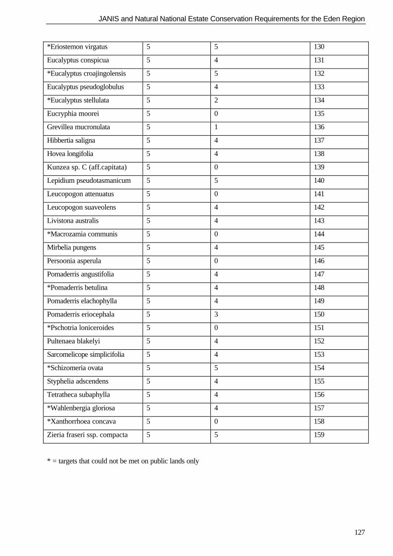
JANIS and Natural National Estate Conservation Requirements for the Eden Region
127
*Eriostemon virgatus 5 5 130
Eucalyptus conspicua 5 4 131
*Eucalyptus croajingolensis 5 5 132
Eucalyptus pseudoglobulus 5 4 133
*Eucalyptus stellulata 5 2 134
Eucryphia moorei 5 0 135
Grevillea mucronulata 5 1 136
Hibbertia saligna 5 4 137
Hovea longifolia 5 4 138
Kunzea sp. C (aff.capitata) 5 0 139
Lepidium pseudotasmanicum 5 5 140
Leucopogon attenuatus 5 0 141
Leucopogon suaveolens 5 4 142
Livistona australis 5 4 143
*Macrozamia communis 5 0 144
Mirbelia pungens 5 4 145
Persoonia asperula 5 0 146
Pomaderris angustifolia 5 4 147
*Pomaderris betulina 5 4 148
Pomaderris elachophylla 5 4 149
Pomaderris eriocephala 5 3 150
*Pschotria loniceroides 5 0 151
Pultenaea blakelyi 5 4 152
Sarcomelicope simplicifolia 5 4 153
*Schizomeria ovata 5 5 154
Styphelia adscendens 5 4 155
Tetratheca subaphylla 5 4 156
*Wahlenbergia gloriosa 5 4 157
*Xanthorrhoea concava 5 0 158
Zieria fraseri ssp. compacta 5 5 159
* = targets that could not be met on public lands only
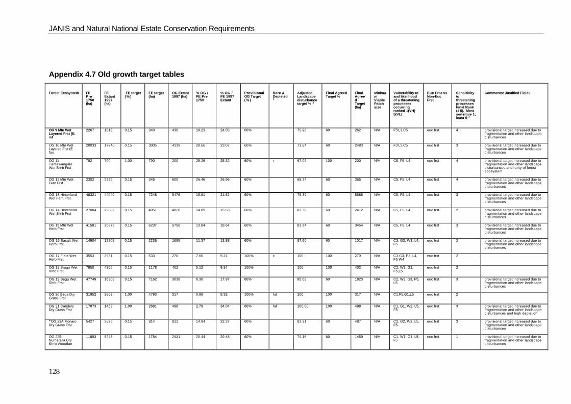
JANIS and Natural National Estate Conservation Requirements
128
Appendix 4.7 Old growth target tables
Forest Ecosystem FEPre1750(ha)
FEExtant1997(ha)
FE target( % )
FE target(ha)
OG Extant1997 (ha)
% OG /FE Pre1750
% OG /FE 1997Extant
ProvisionalOG Target( % )
Rare &Depleted1
AdjustedLandscapedisturbancetarget % 2
Final AgreedTarget %
FinalAgreedTarget(ha)
MinimumViablePatchsize
Vulnerability toand likelihoodof a threateningprocessesoccurringranked 1(VH)-5(VL)
Euc Frst vsNon-EucFrst
SensitivitytothreateningprocessesFinal Rank(1-5). Mostsensitive 1,least 5 3
Comments: Justified Fields
OG 9 Mtn WetLayered Frst (E.nit
2267 1813 0.15 340 436 19.23 24.05 60% 75.96 60 262 N/A F5'L3,C5 euc frst 4 provisional target increased due tofragmentation and other landscapedisturbances
OG 10 Mtn WetLayered Frst (Efas
20033 17940 0.15 3005 4139 20.66 23.07 60% 73.84 60 2483 N/A F5'L3,C5 euc frst 3 provisional target increased due tofragmentation and other landscapedisturbances
OG 11TantawangaloWet Shrb Frst
792 790 1.00 790 200 25.26 25.32 60% r 67.02 100 200 N/A C5, F5, L4 euc frst 4 provisional target increased due tofragmentation and other landscapedisturbances and rarity of forestecosystem
OG 12 Mtn WetFern Frst
2302 2259 0.15 345 609 26.46 26.96 60% 65.24 60 365 N/A C5, F5, L4 euc frst 4 provisional target increased due tofragmentation and other landscapedisturbances
OG 13 HinterlandWet Fern Frst
48321 44040 0.15 7248 9476 19.61 21.52 60% 75.39 60 5686 N/A C5, F5, L4 euc frst 3 provisional target increased due tofragmentation and other landscapedisturbances
OG 14 HinterlandWet Shrb Frst
27004 25882 0.15 4051 4020 14.89 15.53 60% 82.39 60 2412 N/A C5, F5, L4 euc frst 2 provisional target increased due tofragmentation and other landscapedisturbances
OG 15 Mtn WetHerb Frst
41581 30875 0.15 6237 5756 13.84 18.64 60% 83.94 60 3454 N/A C5, F5, L4 euc frst 3 provisional target increased due tofragmentation and other landscapedisturbances
OG 16 Basalt WetHerb Frst
14904 12209 0.15 2236 1695 11.37 13.88 60% 87.60 60 1017 N/A C3, G3, W3, L4,F5
euc frst 2 provisional target increased due tofragmentation and other landscapedisturbances
OG 17 Flats WetHerb Frst
3553 2931 0.15 533 270 7.60 9.21 100% c 100 100 270 N/A C3,G3, P3, L4,F5 W4
euc frst 2
OG 18 Brogo WetVine Frst
7850 4306 0.15 1178 402 5.12 9.34 100% 100 100 402 N/A C2, W2, G3,F5,L5
euc frst 2
OG 19 Bega WetShrb Frst
47749 16908 0.15 7162 3038 6.36 17.97 60% 95.02 60 1823 N/A C2, W2, G3, F5,L5
euc frst 3 provisional target increased due tofragmentation and other landscapedisturbances
OG 20 Bega DryGrass Frst
31952 3809 1.00 4793 317 0.99 8.32 100% hd 100 100 317 N/A C1,F5,G1,L5 euc frst 2
OG 21 CandeloDry Grass Frst
17873 1463 1.00 2681 498 2.79 34.04 60% hd 100.00 100 498 N/A C1, G1, W2, L5,F5
euc frst 3 provisional target increased due tofragmentation and other landscapedisturbances and high depletion
*'OG 22A MonaroDry Grass Frst
5427 3625 0.15 814 811 14.94 22.37 60% 82.31 60 487 N/A C2, G2, W2, L5,F5
euc frst 3 provisional target increased due tofragmentation and other landscapedisturbances
OG 22BNumeralla DryShrb Woodlan
11893 8248 0.15 1784 2431 20.44 29.48 60% 74.16 60 1459 N/A C1, W1, G1, L5,F5
euc frst 1 provisional target increased due tofragmentation and other landscapedisturbances
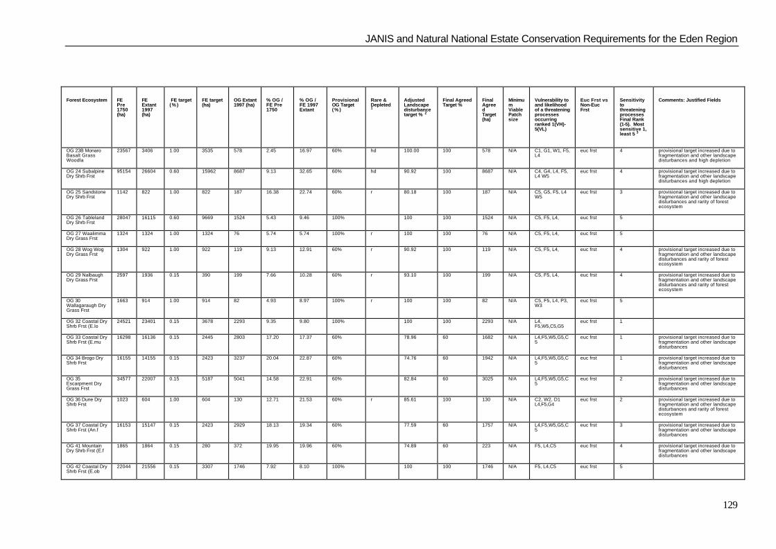
JANIS and Natural National Estate Conservation Requirements for the Eden Region
129
Forest Ecosystem FEPre1750(ha)
FEExtant1997(ha)
FE target( % )
FE target(ha)
OG Extant1997 (ha)
% OG /FE Pre1750
% OG /FE 1997Extant
ProvisionalOG Target( % )
Rare &Depleted1
AdjustedLandscapedisturbancetarget % 2
Final AgreedTarget %
FinalAgreedTarget(ha)
MinimumViablePatchsize
Vulnerability toand likelihoodof a threateningprocessesoccurringranked 1(VH)-5(VL)
Euc Frst vsNon-EucFrst
SensitivitytothreateningprocessesFinal Rank(1-5). Mostsensitive 1,least 5 3
Comments: Justified Fields
OG 23B MonaroBasalt GrassWoodla
23567 3406 1.00 3535 578 2.45 16.97 60% hd 100.00 100 578 N/A C1, G1, W1, F5,L4
euc frst 4 provisional target increased due tofragmentation and other landscapedisturbances and high depletion
OG 24 SubalpineDry Shrb Frst
95154 26604 0.60 15962 8687 9.13 32.65 60% hd 90.92 100 8687 N/A C4, G4, L4, F5,L4 W5
euc frst 4 provisional target increased due tofragmentation and other landscapedisturbances and high depletion
OG 25 SandstoneDry Shrb Frst
1142 822 1.00 822 187 16.38 22.74 60% r 80.18 100 187 N/A C5, G5, F5, L4W5
euc frst 3 provisional target increased due tofragmentation and other landscapedisturbances and rarity of forestecosystem
OG 26 TablelandDry Shrb Frst
28047 16115 0.60 9669 1524 5.43 9.46 100% 100 100 1524 N/A C5, F5, L4, euc frst 5
OG 27 WaalimmaDry Grass Frst
1324 1324 1.00 1324 76 5.74 5.74 100% r 100 100 76 N/A C5, F5, L4, euc frst 5
OG 28 Wog WogDry Grass Frst
1304 922 1.00 922 119 9.13 12.91 60% r 90.92 100 119 N/A C5, F5, L4, euc frst 4 provisional target increased due tofragmentation and other landscapedisturbances and rarity of forestecosystem
OG 29 NalbaughDry Grass Frst
2597 1936 0.15 390 199 7.66 10.28 60% r 93.10 100 199 N/A C5, F5, L4, euc frst 4 provisional target increased due tofragmentation and other landscapedisturbances and rarity of forestecosystem
OG 30Wallagaraugh DryGrass Frst
1663 914 1.00 914 82 4.93 8.97 100% r 100 100 82 N/A C5, F5, L4, P3,W3
euc frst 5
OG 32 Coastal DryShrb Frst (E.lo
24521 23401 0.15 3678 2293 9.35 9.80 100% 100 100 2293 N/A L4,F5,W5,C5,G5
euc frst 1
OG 33 Coastal DryShrb Frst (E.mu
16298 16136 0.15 2445 2803 17.20 17.37 60% 78.96 60 1682 N/A L4,F5,W5,G5,C5
euc frst 1 provisional target increased due tofragmentation and other landscapedisturbances
OG 34 Brogo DryShrb Frst
16155 14155 0.15 2423 3237 20.04 22.87 60% 74.76 60 1942 N/A L4,F5,W5,G5,C5
euc frst 1 provisional target increased due tofragmentation and other landscapedisturbances
OG 35Escarpment DryGrass Frst
34577 22007 0.15 5187 5041 14.58 22.91 60% 82.84 60 3025 N/A L4,F5,W5,G5,C5
euc frst 2 provisional target increased due tofragmentation and other landscapedisturbances
OG 36 Dune DryShrb Frst
1023 604 1.00 604 130 12.71 21.53 60% r 85.61 100 130 N/A C2, W2, D1L4,F5,G4
euc frst 2 provisional target increased due tofragmentation and other landscapedisturbances and rarity of forestecosystem
OG 37 Coastal DryShrb Frst (An.f
16153 15147 0.15 2423 2929 18.13 19.34 60% 77.59 60 1757 N/A L4,F5,W5,G5,C5
euc frst 3 provisional target increased due tofragmentation and other landscapedisturbances
OG 41 MountainDry Shrb Frst (E.f
1865 1864 0.15 280 372 19.95 19.96 60% 74.89 60 223 N/A F5, L4,C5 euc frst 4 provisional target increased due tofragmentation and other landscapedisturbances
OG 42 Coastal DryShrb Frst (E.ob
22044 21556 0.15 3307 1746 7.92 8.10 100% 100 100 1746 N/A F5, L4,C5 euc frst 5
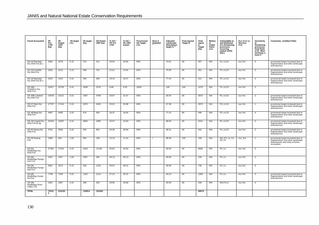
JANIS and Natural National Estate Conservation Requirements
130
Forest Ecosystem FEPre1750(ha)
FEExtant1997(ha)
FE target( % )
FE target(ha)
OG Extant1997 (ha)
% OG /FE Pre1750
% OG /FE 1997Extant
ProvisionalOG Target( % )
Rare &Depleted1
AdjustedLandscapedisturbancetarget % 2
Final AgreedTarget %
FinalAgreedTarget(ha)
MinimumViablePatchsize
Vulnerability toand likelihoodof a threateningprocessesoccurringranked 1(VH)-5(VL)
Euc Frst vsNon-EucFrst
SensitivitytothreateningprocessesFinal Rank(1-5). Mostsensitive 1,least 5 3
Comments: Justified Fields
OG 43 MountainDry Shrb Frst (E.c
2492 2479 0.15 374 512 20.54 20.65 60% 74.01 60 307 N/A F5, L4,C5 euc frst 3 provisional target increased due tofragmentation and other landscapedisturbances
OG 44 FoothillsDry Shrb Frst
3326 3142 0.15 499 752 22.61 23.94 60% 70.95 60 451 N/A F5, L4,C5 euc frst 3 provisional target increased due tofragmentation and other landscapedisturbances
OG 45 MountainDry Shrb Frst (E.s
2024 1915 0.15 304 369 18.23 19.27 60% 77.44 60 221 N/A F5, L4,C5 euc frst 4 provisional target increased due tofragmentation and other landscapedisturbances
OG 46ATimbillica DryShrb Frst
22917 22792 0.15 3438 1579 6.89 6.93 100% 100 100 1579 N/A F5, L4,C5 euc frst 3
OG 46B LowlandDry Shrb Frst
15978 15121 0.15 2397 4789 29.97 31.67 60% 60.04 60 2873 N/A F5, L4,C5 euc frst 3 provisional target increased due tofragmentation and other landscapedisturbances
OG 47 Eden DryShrb Frst
17797 17141 0.15 2670 4453 25.02 25.98 60% 67.38 60 2672 N/A F5, L4,C5 euc frst 1 provisional target increased due tofragmentation and other landscapedisturbances
OG 48 Bega DryShrb Frst
4497 4455 0.15 674 826 18.37 18.54 60% 77.23 60 496 N/A F5, L4,C5 euc frst 4 provisional target increased due tofragmentation and other landscapedisturbances
OG 49 Coastal DryShrb Frst (E.ag
32334 31837 0.15 4850 3385 10.47 10.63 60% 88.93 60 2031 N/A F5, L4,C5 euc frst 3 provisional target increased due tofragmentation and other landscapedisturbances
OG 50 Genoa DryShrb Frst
3702 3026 0.15 555 903 24.39 29.84 60% 68.31 60 542 N/A F5, L4,C5 euc frst 2 provisional target increased due tofragmentation and other landscapedisturbances
OG 58 SwampFrst
1080 953 1.00 953 109 10.10 11.44 60% r 89.48 100 109 N/A W3, P3, L5, C4,G5, F5
euc_frst 1 provisional target increased due tofragmentation and other landscapedisturbances and rarity of forestecosystem
OG W1Wadbilliga DryShrb Frst
27352 27341 0.15 4103 11109 40.62 40.63 60% 60.00 60 6665 N/A F5, L4, euc frst 5
OG W2Wadbilliga RangeAsh Frst
1007 1007 1.00 1007 394 39.13 39.13 60% 60.00 60 236 N/A F5, L4, euc frst 2
OG W4Wadbilliga RangeWet Frst
3501 3214 0.15 525 1226 35.01 38.15 60% 60.00 60 736 N/A F5, L4, euc frst 5
OG W5Wadbilliga GorgeDry Frst
7748 7239 0.15 1162 2110 27.23 29.15 60% 64.10 60 1266 N/A F5, L4, euc frst 5 provisional target increased due tofragmentation and other landscapedisturbances
OG W6Wadbilliga RiverValley Frst
1902 1897 0.15 285 563 29.60 29.68 60% 60.59 60 338 N/A W3,F5,L4 euc frst 4
TOTAL 751513
515152 125814 102453 69070

JANIS and Natural National Estate Conservation Requirements for the Eden Region
131
Rare & Depleted 1r = rarehd = highly depletedc = worthy of consideration
Adjusted Landscape disturbance target % 2
(equals IF (provo % targ >100% =100) AND IF (provo % targ <100% THEN (100-((OG % Orig Targ -3)/27)*40). Where formula equals < 60% then 60% held and formula ignored)104.44
Sensitivity to threatening processes Final Rank (1-5). Highest sensitivity 1, least 5 31 = ratio of oldgrowth the young and recently disturbed forest is less than 0.252 = ratio of oldgrowth the young and recently disturbed forest is between 0.25 and 0.503 = ratio of oldgrowth the young and recently disturbed forest is between 0.50 and 1.004 = ratio of oldgrowth the young and recently disturbed forest is between 1.00 and 2.005 = ratio of oldgrowth the young and recently disturbed forest is greater than 2.00
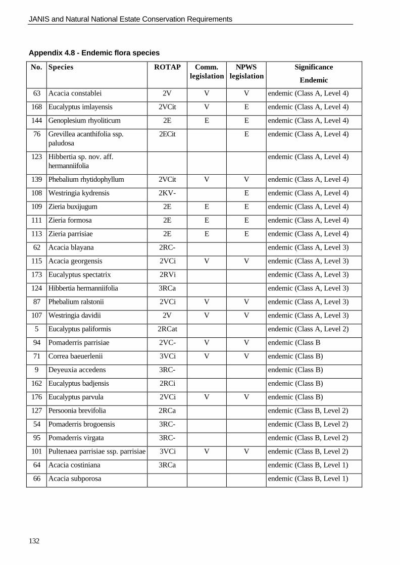
JANIS and Natural National Estate Conservation Requirements
132
Appendix 4.8 - Endemic flora species
No. Species ROTAP Comm.legislation
NPWSlegislation
Significance
Endemic
63 Acacia constablei 2V V V endemic (Class A, Level 4)
168 Eucalyptus imlayensis 2VCit V E endemic (Class A, Level 4)
144 Genoplesium rhyoliticum 2E E E endemic (Class A, Level 4)
76 Grevillea acanthifolia ssp.paludosa
2ECit E endemic (Class A, Level 4)
123 Hibbertia sp. nov. aff.hermanniifolia
endemic (Class A, Level 4)
139 Phebalium rhytidophyllum 2VCit V V endemic (Class A, Level 4)
108 Westringia kydrensis 2KV- E endemic (Class A, Level 4)
109 Zieria buxijugum 2E E E endemic (Class A, Level 4)
111 Zieria formosa 2E E E endemic (Class A, Level 4)
113 Zieria parrisiae 2E E E endemic (Class A, Level 4)
62 Acacia blayana 2RC- endemic (Class A, Level 3)
115 Acacia georgensis 2VCi V V endemic (Class A, Level 3)
173 Eucalyptus spectatrix 2RVi endemic (Class A, Level 3)
124 Hibbertia hermanniifolia 3RCa endemic (Class A, Level 3)
87 Phebalium ralstonii 2VCi V V endemic (Class A, Level 3)
107 Westringia davidii 2V V V endemic (Class A, Level 3)
5 Eucalyptus paliformis 2RCat endemic (Class A, Level 2)
94 Pomaderris parrisiae 2VC- V V endemic (Class B
71 Correa baeuerlenii 3VCi V V endemic (Class B)
9 Deyeuxia accedens 3RC- endemic (Class B)
162 Eucalyptus badjensis 2RCi endemic (Class B)
176 Eucalyptus parvula 2VCi V V endemic (Class B)
127 Persoonia brevifolia 2RCa endemic (Class B, Level 2)
54 Pomaderris brogoensis 3RC- endemic (Class B, Level 2)
95 Pomaderris virgata 3RC- endemic (Class B, Level 2)
101 Pultenaea parrisiae ssp. parrisiae 3VCi V V endemic (Class B, Level 2)
64 Acacia costiniana 3RCa endemic (Class B, Level 1)
66 Acacia subporosa endemic (Class B, Level 1)
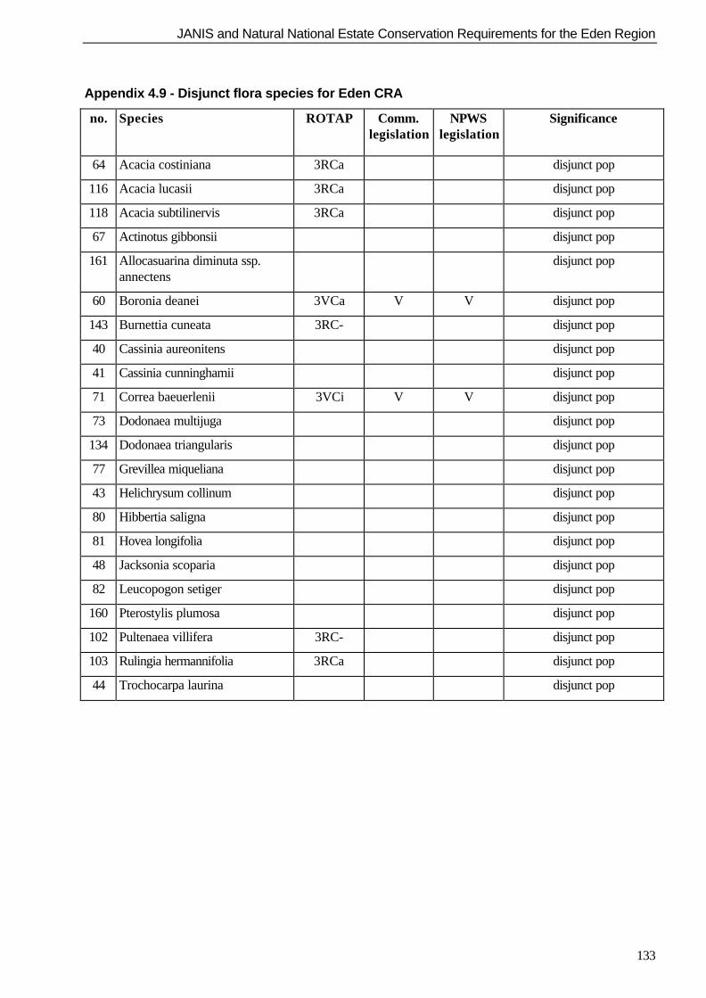
JANIS and Natural National Estate Conservation Requirements for the Eden Region
133
Appendix 4.9 - Disjunct flora species for Eden CRA
no. Species ROTAP Comm.legislation
NPWSlegislation
Significance
64 Acacia costiniana 3RCa disjunct pop
116 Acacia lucasii 3RCa disjunct pop
118 Acacia subtilinervis 3RCa disjunct pop
67 Actinotus gibbonsii disjunct pop
161 Allocasuarina diminuta ssp.annectens
disjunct pop
60 Boronia deanei 3VCa V V disjunct pop
143 Burnettia cuneata 3RC- disjunct pop
40 Cassinia aureonitens disjunct pop
41 Cassinia cunninghamii disjunct pop
71 Correa baeuerlenii 3VCi V V disjunct pop
73 Dodonaea multijuga disjunct pop
134 Dodonaea triangularis disjunct pop
77 Grevillea miqueliana disjunct pop
43 Helichrysum collinum disjunct pop
80 Hibbertia saligna disjunct pop
81 Hovea longifolia disjunct pop
48 Jacksonia scoparia disjunct pop
82 Leucopogon setiger disjunct pop
160 Pterostylis plumosa disjunct pop
102 Pultenaea villifera 3RC- disjunct pop
103 Rulingia hermannifolia 3RCa disjunct pop
44 Trochocarpa laurina disjunct pop

JANIS and Natural National Estate Conservation Requirements
134
Appendix 4.10 - National Estate assessment workshop report
Identification of non-targeted JANIS and National Estate natural values CRA/RFA Eden region 20 August 1996
Participants:
Dr Brendan Mackey (Geography, ANU) Philip Hodgson (Environment Australia) Phillip Gilmour (ecologist) Karl Bossard (Environment Australia) Dr Dan Faith (CSIRO Wildlife & Ecology) Geoff Moore (NSW NPWS) Assoc Prof Craig Moritz (Zoology, UQ) Simon Ferrier (NSW NPWS) Dr Bruce Wellington (ecologist), Ian Barnes (State Forests, NSW) Bronwen Wicks (Environment Australia) Background:
National estate values are amongst those required to be assessed as part of the Comprehensive RegionalAssessment of forested areas in Australia. Assessment of national estate values in a regional contextinvolves a comparative evaluation of the significance of places having one or more attributes or valuesderived from the national estate criteria.
A place is deemed significant for a particular national estate value when the expression of the value at theplace is assessed to be at or above a certain threshold of significance. Thresholds of significance aredeveloped for each value, and are based on the level of current knowledge about the nature and extent ofnatural values, and their distribution in the landscape at local, regional and national levels.
The assessment of national estate values in a regional context requires:
n identification and mapping of relevant values in the region;
n assessment of the expression of values at particular places against thresholds of significance;
n identification of places with values above appropriate thresholds of significance.
Aim of workshop:
The aim of the workshop was to provide advice concerning the use of currently available data layers for theEden CRA region for identifying places with national estate values associated with:1) Centres of endemism;2) Places of refugia;3) Areas important for relictual species;4) Areas important for disjunct species and species at their biogeographic limits;5) Areas of high diversity and/or richness.
Data:
Data being used for the Eden CRA include new data layers, and improved and extended versions of datalayers used for previous assessment work in the region, such as the IAP and DFA processes. Some datalayers for Eden, including the forest vegetation and growth stages maps, and distribution models for somefauna species are currently in varying stages of development.
Timelines:
All derived outputs to meet national estate requirements for the Eden RFA are required to be completed by12 September 1997. The outputs will be used for the integration phase of the RFA in conjunction withdecision support systems, including C-Plan.
It is estimated that some of the baseline datasets necessary to derive outputs required for national estateassessment (for example forest type mapping) will not be available before the end of August 1997. As a
JANIS and Natural National Estate Conservation Requirements for the Eden Region
135
result, only a limited amount of time will be available to undertake the necessary derivation work for nationalestate values.
The Workshop was asked to consider these time constraints when it formulated its advice concerning work tomeet national estate, and consequently JANIS, requirements for the Eden CRA region.
National estate assessment
Some national estate values have specific targets that have been set as part of the JANIS criteria. However,there are also national estate values that have no JANIS equivalents, and others for which there are JANISequivalents, but no specific conservation targets.
Recommendations
The Workshop recommended that:
1) all options identified in relation to values with specific targets are also evaluated for their relativecontribution to those values without targets in the application of C-Plan;
2) the integration phase attempt to identify options that maximise the protection of all national estate values,including those values without specific targets set under JANIS.
Such an approach would provide a mechanism of ensuring that the trade-offs for national estate valueswithout specific targets are explicitly considered in the integration phase.
1. Endemism and centres of endemism
Definitions
n Endemics were defined to include the following two classes of taxa:
Class A endemics - species of plants and animals whose natural distribution is wholly confined to theEden region; and
Class B endemics - species of plants and animals whose natural distribution is mainly (>50%) in theEden region, and with additional populations confined to adjacent regions
n Centres of Endemism were defined as places which include a number of endemic species:
Endemic Flora
Distribution
n Rhyolite outcrops were identified as an important factor associated with endemic flora in the Eden region.Many of the endemic plant species in the region are confined to rhyolite outcrops. Some species (egZieria sp.) have distributions confined to one or a few outcrops, whereas other taxa (eg Westringia sp.)may be distributed widely on rhyolite outcrops throughout the region.
n It was noted that there is sometimes a good correlation between the distributions of endemic plant speciesin the region, with several taxa likely to be found at the same locality.
n In contrast, there is likely to be little or no correlation between the distributions of endemic plant andanimal taxa.Endemic plant taxa are often found in extreme habitats (eg the acid volcanic soils associated with rhyoliteoutcrops) whereas faunal diversity and the incidence of endemic animal taxa are more likely to beassociated with other factors such as areas of higher soil nutrient availability.
Class A endemics
n The distribution of Class A plant endemics in the region is reasonably well defined based on available siterecords and expert knowledge.
n The distribution of Class A plant endemics tends to be restricted and, for many species including thoseassociated with rhyolite outcrops, is reasonably well known.
n Modelling is unlikely to be of much use for predicting the distribution of Class A species.
JANIS and Natural National Estate Conservation Requirements
136
n The distribution of some Class A plant endemics has been mapped (likely accuracy - ca 100m +).
Class B endemics
n The distribution of Class B plant endemics in the region is broader and more difficult to define.
n Most Class B plant endemics are likely to have a restricted distribution, but there are also some species(eg Acacia porosa) which are widely distributed in the Eden region and these endemics are thereforelocally common.
n Many Class B endemics are likely to be associated with the escarpment, and many species will thereforebe represented in the reserve system.
Centres of endemism
n The co-occurrence of endemic species is an important criterion for a centre of endemism.
n Centres of endemism may be associated with particular processes leading to endemicity; they thereforecan be important in predicting endemicity amongst other species.
n Identification of places that support more than one endemic species is important for identifying possiblecentres of endemism.
Thresholds
n In discussing thresholds for endemism, the Workshop identified the following levels:n Level 4 - endemic to the region, and occurring at only one locality (Class A endemic)n Level 3 - endemic to the region and occurring at more than one locality (Class A endemic)n Level 2 - mainly endemic to the region and rare elsewhere (Class B endemic)n Level 1 - mainly endemic to the region, but common in adjacent regions (Class B endemic)
n It is important to ensure that all grid cells (or polygons) with expressions of endemism at Level 4 areincluded.
n It is also important to ensure that all grid cells with expressions of endemism at Level 3 are included wherethe endemic species is uncommon.
n Grid cells with expressions of endemism at Level 3 for more than 2 species may be associated withcentres of endemicity and should also be included.
n Thresholds for Levels 2 and 1 (Class B endemics) will need to be determined based on a consideration ofall of the available distribution data for each species.
Actions
It was agreed that Phil Gilmore would identify plant species endemic to the region, and categorise eachspecies according to the classes and levels of endemism outlined above.
Endemic fauna
Distribution
n Distribution models are currently available for 300 fauna species in the region, including those on the list ofpriority species. The available data concern higher vertebrates, including mammals, birds, reptiles andamphibians.
n Little is currently known of the distribution of aquatic fauna or invertebrates in the region. Invertebratesare thought likely to have a very high diversity in the region, and to include many endemic species, butthere is little or no data concerning either the taxa involved or their distribution in the region.
JANIS and Natural National Estate Conservation Requirements for the Eden Region
137
Class A endemics
n There are no Class A endemics amongst the higher vertebrates as currently known for the region,although it should be noted that the distribution of spatially-constrained species (for example frogs) has yetto be considered in detail.
n Too little is currently known of the distribution of lower fauna taxa including invertebrates in the region todetermine whether these include any Class A endemics.
Class B endemics
n The Long-footed Potoroo was thought likely to be a Class B endemic for the Eden region on the basis ofits distribution which is confined to the south-east IBRA region, including the Eden and adjacent EastGippsland RFA regions.
n It was thought that other likely Class B endemics for the Eden region would include some species ofreptiles and amphibians.
n Too little is currently known of the distribution of lower fauna taxa including invertebrates in the region todetermine whether these include any Class B endemics.
Thresholds
n The Workshop agreed that a conceptual approach similar to that outlined above for plants should be usedto identify fauna species above threshold for national estate value related to endemism. This would involvethe following steps:
1) Finalise the list of fauna species for the region;
2) Identify relevant experts for each major taxonomic group;
3) Identify species above threshold in relation to endemism, using relevant experts.
Actions
It was agreed that the list of 300 fauna species for the region would be used and Geoff Moore wouldapproach relevant experts to identify the endemic status of fauna species.
It was agreed that Karl Bossard would approach Penelope Greenslade (CSIRO Entomology) (if timepermitted) to provide expert advice regarding the known or possible endemic status of any invertebrates in theregion .
Recommendations
n Requirements for the integration phase (C-Plan) should include layers with defined areas that representvalues associated with endemism, including centres of endemism.
n Statements indicating the following should be included in any discussion of national estate valuesassociated with endemism and centres of endemism for the Eden CRA/RFA:
a) little is currently known of the distribution of lower plant taxa including bryophytes and fungi and thesetaxa may include a number of endemic species;
b) centres of endemism for plants are unlikely to predict centres of endemism for invertebrates;
c) high levels of diversity and endemism are known to occur amongst invertebrate fauna for the region,but that there are no data available to characterise the distribution of these taxa;
d) it is unlikely that the reserve system will necessarily include adequate representation of endemicinvertebrate species; and
e) there is a need to ensure that appropriate data concerning the distribution and status of lower plant andanimal taxa are collected for use in future planning processes in the region.
Draft rule set for identifying centres of endemism

JANIS and Natural National Estate Conservation Requirements
138
Identify endemic species and centres of endemism:
1) Identify all endemic species for the region;
2) Classify endemic species into class and level (see above);
3) Identify appropriate methods and spatial scales for representing species distributions(methods will include grid cells for site data, and polygons for modelled distributions;grid resolution will need to be as fine as possible, but broad enough to avoid false absences);
4) Identify places (grid squares or polygons) with endemic values at Level 4, and Level 3 where the speciesare uncommon (these areas above threshold);
5) Identify places (grid squares or polygons) with endemic species at Levels 2 and 1 and assess these in thecontext of the distribution of their endemic species outside the region;
6) Identify any places above threshold in the region for Levels 2 and 1 species;
7) Identify all places which have more than one endemic species and therefore are possible centres ofendemism;
8) Rank all possible centres of endemism against their total number of endemic species and their number ofspecies at each level of endemism;
9) Identify thresholds for centres of endemism based on an assessment of all possible places for number ofendemics, and levels of endemism in the region,
10) Identify places above threshold for number of endemics as centres of endemism.
Ensure protection of endemic values:
1) Quantify the contribution to protecting endemic values of each land-use option generated to achieveparticular targets for other values using C-Plan;
2) Rank the options on the basis of their contribution to endemic values;
3) Ensure that the selection of options attempts to maximise the contribution to protecting endemic values;
4) For land-use options selected, identify places with above threshold value that are not adequately protectedby tenure arrangements;
5) Ensure that other arrangements, including prescriptive management arrangements, are agreed to protectall endemic values above threshold.
2. Places of refugia
Definitions
n Refugia are places where species are not eliminated by a threatening process. The impacts of thethreatening process are either prevented or buffered, and species are able to persist despite beingeliminated from other (non-refugial) areas.
n Refugia include places to which species can move to avoid a threatening process.
n Refugia are places where species can persist and subsequently disperse from following large fluctuationsin threatening processes.
Threatening processes
n Threatening processes identified as relevant to refugia in the Eden region, and of high priority for nationalestate assessment in the CRA/RFA process included:
- climate change (long-term);
- drought;
- fire.
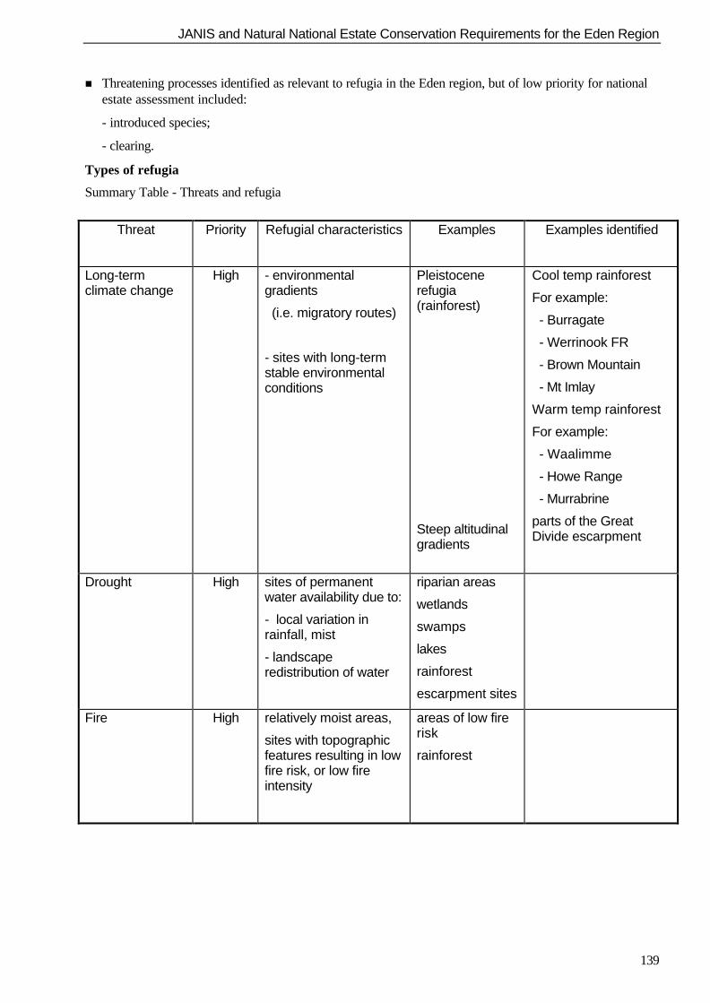
JANIS and Natural National Estate Conservation Requirements for the Eden Region
139
n Threatening processes identified as relevant to refugia in the Eden region, but of low priority for nationalestate assessment included:
- introduced species;
- clearing.
Types of refugia
Summary Table - Threats and refugia
Threat
Priority Refugial characteristics Examples Examples identified
Long-termclimate change
High - environmentalgradients
(i.e. migratory routes)
- sites with long-termstable environmentalconditions
Pleistocenerefugia(rainforest)
Steep altitudinalgradients
Cool temp rainforest
For example:
- Burragate
- Werrinook FR
- Brown Mountain
- Mt Imlay
Warm temp rainforest
For example:
- Waalimme
- Howe Range
- Murrabrine
parts of the GreatDivide escarpment
Drought High sites of permanentwater availability due to:
- local variation inrainfall, mist
- landscaperedistribution of water
riparian areas
wetlands
swamps
lakes
rainforest
escarpment sites
Fire High relatively moist areas,
sites with topographicfeatures resulting in lowfire risk, or low fireintensity
areas of low firerisk
rainforest
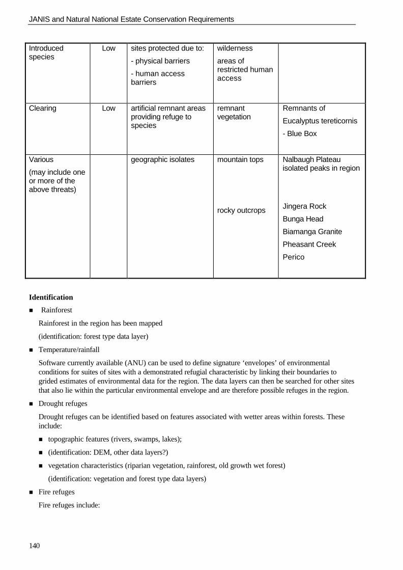
JANIS and Natural National Estate Conservation Requirements
140
Introducedspecies
Low sites protected due to:
- physical barriers
- human accessbarriers
wilderness
areas ofrestricted humanaccess
Clearing Low artificial remnant areasproviding refuge tospecies
remnantvegetation
Remnants of
Eucalyptus tereticornis
- Blue Box
Various
(may include oneor more of theabove threats)
geographic isolates mountain tops
rocky outcrops
Nalbaugh Plateauisolated peaks in region
Jingera Rock
Bunga Head
Biamanga Granite
Pheasant Creek
Perico
Identification
n Rainforest
Rainforest in the region has been mapped
(identification: forest type data layer)
n Temperature/rainfall
Software currently available (ANU) can be used to define signature ‘envelopes’ of environmentalconditions for suites of sites with a demonstrated refugial characteristic by linking their boundaries togrided estimates of environmental data for the region. The data layers can then be searched for other sitesthat also lie within the particular environmental envelope and are therefore possible refuges in the region.
n Drought refuges
Drought refuges can be identified based on features associated with wetter areas within forests. Theseinclude:
n topographic features (rivers, swamps, lakes);
n (identification: DEM, other data layers?)
n vegetation characteristics (riparian vegetation, rainforest, old growth wet forest)
(identification: vegetation and forest type data layers)
n Fire refuges
Fire refuges include:
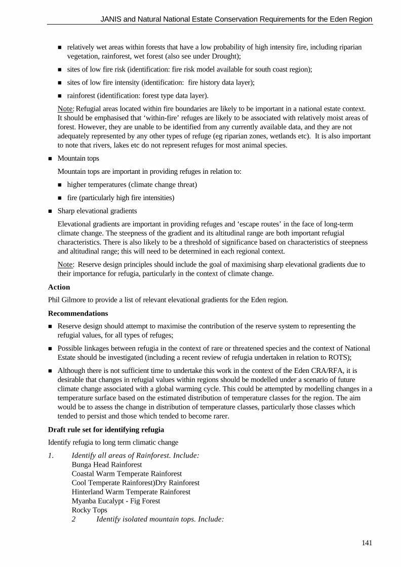
JANIS and Natural National Estate Conservation Requirements for the Eden Region
141
n relatively wet areas within forests that have a low probability of high intensity fire, including riparianvegetation, rainforest, wet forest (also see under Drought);
n sites of low fire risk (identification: fire risk model available for south coast region);
n sites of low fire intensity (identification: fire history data layer);
n rainforest (identification: forest type data layer).
Note: Refugial areas located within fire boundaries are likely to be important in a national estate context.It should be emphasised that ‘within-fire’ refuges are likely to be associated with relatively moist areas offorest. However, they are unable to be identified from any currently available data, and they are notadequately represented by any other types of refuge (eg riparian zones, wetlands etc). It is also importantto note that rivers, lakes etc do not represent refuges for most animal species.
n Mountain tops
Mountain tops are important in providing refuges in relation to:
n higher temperatures (climate change threat)
n fire (particularly high fire intensities)
n Sharp elevational gradients
Elevational gradients are important in providing refuges and ‘escape routes’ in the face of long-termclimate change. The steepness of the gradient and its altitudinal range are both important refugialcharacteristics. There is also likely to be a threshold of significance based on characteristics of steepnessand altitudinal range; this will need to be determined in each regional context.
Note: Reserve design principles should include the goal of maximising sharp elevational gradients due totheir importance for refugia, particularly in the context of climate change.
Action
Phil Gilmore to provide a list of relevant elevational gradients for the Eden region.
Recommendations
n Reserve design should attempt to maximise the contribution of the reserve system to representing therefugial values, for all types of refuges;
n Possible linkages between refugia in the context of rare or threatened species and the context of NationalEstate should be investigated (including a recent review of refugia undertaken in relation to ROTS);
n Although there is not sufficient time to undertake this work in the context of the Eden CRA/RFA, it isdesirable that changes in refugial values within regions should be modelled under a scenario of futureclimate change associated with a global warming cycle. This could be attempted by modelling changes in atemperature surface based on the estimated distribution of temperature classes for the region. The aimwould be to assess the change in distribution of temperature classes, particularly those classes whichtended to persist and those which tended to become rarer.
Draft rule set for identifying refugia
Identify refugia to long term climatic change
1. Identify all areas of Rainforest. Include:Bunga Head RainforestCoastal Warm Temperate RainforestCool Temperate Rainforest)Dry RainforestHinterland Warm Temperate RainforestMyanba Eucalypt - Fig ForestRocky Tops2 Identify isolated mountain tops. Include:

JANIS and Natural National Estate Conservation Requirements
142
Burragate Peak – Jingera Rock (areas above 750 m)Mount Imlay (areas above 800 m)Mount Poole (areas above 675 m)Mumbulla Mountain (areas above 675 m)Murrabrine (Mountain) (areas above 725 m)Nadgee Mountain (Mt Nagha) (areas above 450 m)Nungatta Plateau (areas above 800 m)Waalimma Peak (areas above 625 m)Wolumla Peak (areas above 675 m)Nalbough Plateau (areas above 975 m) White Rock Mountain Wog Wog Mountain
Identify Drought Refugia
3. Use identified rainforest (above)
4. Identify riparian vegetation, old growth wet forest and wetlands. Include:Southern Riparian ScrubNorthern Riparian ScrubRiverine ForestOld Growth Mountain Wet Layered Forest (Shining Gum) Mountain Wet Layered Forest (Brown Barrel) Tantawangalo Wet Shrub Forest Mountain Wet Fern Forest (Brown Barrel-Gum) Hinterland Wet Fern Forest (Gum) Hinterland Wet Shrub Forest (Stringybark) Mountain Wet Herb Forest (Messmate-Gum) Basalt Wet Herb Forest (Brown Barrel-Gum) Flats Wet Herb Forest (Ribbon Gum) Brogo Wet Vine Forest (Red Gum) Brogo Wet Shrub Forest (Peppermint-Blue Box) Wadbilliga Wet Shrub ForestSwamp HeathLowland SwampSwamp ForestSubalpine BogFloodplain WetlandsEstuarine Wetland
Identify Fire refugia
5. Use identified rainforest, wetlands and mountain tops (above)
6. Identify rocky outcrops. Include:Jingera RockBunga HeadBiamanga GranitePheasant’s PeakPerico Mountain
7. Identify sites of low fire risk (based on fire risk model)
8. Identify sites that are only known to have burnt with low fire intensity (or not at all) (based onfire history data)

JANIS and Natural National Estate Conservation Requirements for the Eden Region
143
9. In the context of all places identified, define threshold of refugial significance inrelation to each type of refugial value
10. Identify those places (grid squares or polygons) with refugial values above threshold for theregion
JANIS and Natural National Estate Conservation Requirements
144
3. Relicts
Definition
Relicts are disjunct populations that have become isolated due to historical factors (for example environmentalchange, evolutionary factors) rather than recent factors (for example due to long distance dispersal).
Relicts are likely to have a high level of significance associated with their rarity in the region, or theirparticular taxonomic status and genetic structure.
Places associated with relicts in the Eden CRA region include:
n mountain tops (high altitude isolates are likely to be relictual)
n heathlands (it is not certain whether these are relictual or recent)
Taxa likely to have national estate significance due to their relictual status in the region include Gondwanicrainforest families. These include:
Monemiaceae
Winteraceae
Eupomateaceae
Eucryphiaceae
Atherospermataceae
Cool temperate rainforest can therefore be used as a surrogate for these relictual values in the Eden region
Other relictual taxa in the region may include:
Prostanthera monticola
Grevillea obtusifolia
Eucalyptus parviflora
primitive taxa (Macrozamia communis)
Draft rule set for identifying places important for relictual species
Identify places important for relictual species:
1) Use identified rainforest and mountain tops (above);
2) Identify heathlands (wet heaths, damp sub-alpine heath and subalpine treeless complex (bog communities))and riparian scrub complex;
3) In the context of all places identified as supporting relictual species, define threshold of significance forrelictual values;
4) Identify those places (grid squares or polygons) with relictual values above threshold for the region.
Ensure protection of places important for relictual species:
5) Quantify the contribution to protecting places important for relictual species of each land-use optiongenerated to achieve particular targets for other values using C-Plan;
6) Rank the options on the basis of their contribution to protecting places important for relictual species;
7) Ensure that the selection of options attempts to maximise the contribution to protecting places importantfor relictual species;
8) For land-use options selected, identify places with above threshold value that are not adequately protectedby tenure arrangements;
JANIS and Natural National Estate Conservation Requirements for the Eden Region
145
9) Ensure that other arrangements, including prescriptive management arrangements are agreed to protect allplaces important for relictual species above threshold.
4. Disjunct populations, biogeographic limits
Definition
Disjunct populations are defined as those that are isolated geographically from other populations of the samespecies.
Disjunct flora
Action
Species with disjunct populations:
n Geoff Moore to provide relevant species lists (David Keith’s report, database) to Phil Gilmore
n Phil Gilmore to use lists to identify:
1) disjunct species
2) species at their biogeographic limits in the region
n Geoff Moore to map distribution of relevant species and identify areas important in relation to disjunctpopulations, and for species at their biogeographic limits in the region
Unusual habitats in the region
(For example, Eucalyptus tereticornis, E. maidenii on basalt)
n Phil Gilmore to examine lists provided by Geoff Moore for unusual habitats
n Phil Gilmore to discuss these with David Keith, Doug Binns (Sydney)
Disjunct communities
n Phil Gilmore to check available information re these
Disjunct fauna
Action
(For example, Long-footed Potoroo)
n Geoff Moore to identify relevant species
Draft rule set for identifying places important fordisjunct populations and populations at their biogeographical limits
Identify places important for disjunct populations, biogeographical limits
1) Identify species that are disjunct or at their biogeographical limit in the region;
2) Identify unusual habitats and disjunct communities in the region;
3) Identify appropriate methods and spatial scales for representing the distributions of 1 and 2 in the region(methods will include grid cells for site data, and polygons for mapped or modelled distributions; gridresolution will need to be as fine as possible, but broad enough to avoid false absences);
4) Identify places (grid squares or polygons) with disjunct species, species at their biogeographical limits,unusual habitats, disjunct communities;
5) In the context of all places identified in 4. above, define thresholds of significance for these values in aregional context;
6) Identify places above threshold in the region for these values;
7) Ensure protection of values associated with disjunct populations, biogeographical limits;
JANIS and Natural National Estate Conservation Requirements
146
8) Quantify the contribution, to protecting places important for disjunct populations and for species at theirbiogeographical limit, of each land-use option generated to achieve particular targets for other values usingC-Plan;
9) Rank the options on the basis of their contribution to protecting places important for disjunct populationsand for species at their biogeographical limit;
10) Ensure that the selection of options attempts to maximise the contribution to protecting places importantfor disjunct populations and for species at their biogeographical limit;
11) For land-use options selected, identify places with above threshold value that are not adequately protectedby tenure arrangements;
12) Ensure that other arrangements, including prescriptive management arrangements are agreed to protect allplaces important for disjunct populations and for species at their biogeographical limit above threshold.
5. Areas of high diversity/richness
Diversity can be expressed as alpha diversity (species richness at or within a site), beta diversity (speciesrichness between sites), and gamma diversity (diversity at landscape scale). The Workshop noted that bothalpha and gamma diversity are relevant to assessing national estate values for diversity.
Difficulties exist in estimating diversity for the Eden region based on the flora data as these are available onlyas sample records. There is also a strong sampling bias, with little data available for private forests.
The option exists of developing surrogates for diversity based on the available biotic and abiotic datasets forthe region. These can be used to develop indices of heterogeneity at relevant scales. For example, it would bepossible to use 2 resolutions of grid cells. Compartment and coupe scales are also currently in use for theregion. These can vary depending on management factors such as accessibility, but are roughly in the orderof 200 ha (compartments) and 50 ha (coupes).
Recommendations
n Forest types be used as surrogates for diversity at the broader scale in the Eden region.
n At the finer scale, intra-forest type diversity be estimated based on the modelled environmental variationwithin each forest type.
n Compartments can then be ranked according to their relative richness at the different scales, and areas ofhigher diversity identified based on the richest compartments.
Draft rule set for identifying areas of high diversity/richness
Identify places important as areas of high ecosystem diversity/richness:
1) Intersect forest ecosystem/forest type layer with planning unit (compartment) layer;
2) Calculate the number of ecosystem types in each compartment and divide by the size of the compartment(ha) to provide an index (ecosystem diversity index) of the number of ecosystem types per unit area foreach compartment;
3) Rank the compartments according to their diversity index and in the context of all compartments, definethreshold of significance for areas of high diversity/richness;
4) Identify those places (compartments) with high ecosystem diversity/richness above threshold for theregion.
Identify places important as areas of high fauna diversity/richness:
1) Intersect fauna models with planning unit (compartment) layer;
2) Calculate the number of fauna types in each compartment and divide by the size of the compartment (ha)to provide an index (fauna diversity index) of the number of fauna types per unit area for eachcompartment;
JANIS and Natural National Estate Conservation Requirements for the Eden Region
147
3) Rank the compartments according to their diversity index and in the context of all compartments, definethreshold of significance for areas of high fauna diversity/richness;
4) Identify those places (compartments) with high fauna diversity/richness above threshold for the region.
Ensure protection of places important as areas of high diversity/richness:
1) Quantify the contribution to protecting places important as areas of high diversity/richness for each land-use option generated to achieve particular targets for other values using C-Plan;
2) Rank the options on the basis of their contribution to protecting places as areas of high diversity/richness
3) Ensure that the selection of options attempts to maximise the contribution to protecting places important asareas of high diversity/richness;
4) For land-use options selected, identify places with above threshold value that are not adequately protectedby tenure arrangements;
5) Ensure that other arrangements, including prescriptive management arrangements are agreed to protect allplaces important as areas of high diversity/richness above threshold.
JANIS and Natural National Estate Conservation Requirements
148
Appendix 4.11 - Australian heritage commission criteria for the register of the NationalEstate
Without limiting the generality of sub-section (1) of the Australian Heritage Commission Act 1975, a placethat is a component of the natural or cultural environment of Australia is to be taken to be a place included inthe National Estate if it has significance or other special value for future generations as well as for thepresent community because of:
Criterion A: Its importance in the course, or pattern, of Australia’s natural or cultural history.
A.1 Importance in the evolution of Australian flora, fauna, landscapes or climate;
A.2 Importance in maintaining existing processes or natural systems at the regional or national scale;
A.3 Importance in exhibiting unusual richness or diversity of flora, fauna, landscapes or cultural features;
A.4 Importance for association with events, developments or cultural phases which have had a significantrole in the human occupation and evolution of the nation, State, region or community.
Criterion B: Its possession of uncommon, rare or endangered aspects of Australia’s natural orcultural history.
B.1 Importance for rare, endangered or uncommon flora, fauna, communities, ecosystems, naturallandscapes or phenomena, or as a wilderness;
B.2 Importance in demonstrating a distinctive way of life, custom, process, land-use, function or design nolonger practised, in danger of being lost, or of exceptional interest.
Criterion C: Its potential to yield information that will contribute to an understanding ofAustralia’s natural or cultural history.
C.1 Importance for information contributing to a wider understanding of Australian natural history, by virtueof its use as a research site, teaching site, type locality, reference or benchmark site;
C.2 Importance for information contributing to a wider understanding of the history of human occupation ofAustralia.
Criterion D: Its importance in demonstrating the principal characteristics of:
(i) a class of Australia’s natural or cultural places; or
(ii) a class of Australia’s natural or cultural environments.
D.1 Importance in demonstrating the principal characteristics of the range of landscapes, environments orecosystems, the attributes of which identify them as being characteristic of their class;
D.2 Importance in demonstrating the principal characteristics of the range of human activities in theAustralian environment (including way of life, custom, process, land-use, function, design or technique).
Criterion E: Its importance in exhibiting particular aesthetic characteristics valued by acommunity or cultural group.
E.1 Importance for a community for aesthetic characteristics held in high esteem or otherwise valued by thecommunity.
Criterion F: Its importance in demonstrating a high degree of creative or technical achievementat a particular period.
F.1 Importance for its technical, creative, design or artistic excellence, innovation or achievement.

JANIS and Natural National Estate Conservation Requirements for the Eden Region
149
Criterion G: Its strong or special associations with a particular community or cultural group forsocial, cultural or spiritual reasons.
G.1 Importance as a place highly valued by a community for reasons of religious, spiritual, symbolic, cultural,educational, or social associations.
Criterion H: Its special association with the life or works of a person, or group of persons, ofimportance in Australia's natural or cultural history.
H.1 Importance for close associations with individuals whose activities have been significant within thehistory of the nation, State or region.