jacques whitford 4-4.8-i - open.alberta.ca · 4.8 fish community the environmental effects...
TRANSCRIPT
4.8 Fish Community .........................................................................................................4-202
4.8.1 Boundaries .....................................................................................................4-205 4.8.1.1 Spatial Boundaries...........................................................................4-205 4.8.1.2 Population Boundaries.....................................................................4-207 4.8.1.3 Temporal Boundaries ......................................................................4-207 4.8.1.4 Administrative Boundaries ...............................................................4-207 4.8.1.5 Technical Boundaries ......................................................................4-208
4.8.2 Description of Existing Conditions ..................................................................4-208 4.8.2.1 General Characteristics ...................................................................4-208 4.8.2.2 Benthic Resources...........................................................................4-209 4.8.2.3 Species Composition and Abundance.............................................4-212 4.8.2.4 Distribution.......................................................................................4-214 4.8.2.5 Life History.......................................................................................4-214 4.8.2.6 Movements ......................................................................................4-214 4.8.2.7 Health and Survival..........................................................................4-217 4.8.2.8 Habitat .............................................................................................4-217 4.8.2.9 Summary .........................................................................................4-220
4.8.3 Potential Interactions, Issues and Concerns ..................................................4-220 4.8.3.1 Construction.....................................................................................4-222 4.8.3.2 Operations .......................................................................................4-222 4.8.3.3 Decommissioning ............................................................................4-224 4.8.3.4 Malfunctions and Accidents .............................................................4-225 4.8.3.5 Past, Present, and Likely Future Projects........................................4-225
4.8.4 Residual Environmental Effects Evaluation Criteria .......................................4-225 4.8.4.1 Rating Categories ............................................................................4-226
4.8.5 Effects Analysis, Mitigation and Residual Environmental Effects Prediction..4-229 4.8.5.1 Construction Phase .........................................................................4-230 4.8.5.2 Operations Phase ............................................................................4-245 4.8.5.3 Decommissioning Phase .................................................................4-296 4.8.5.4 Malfunctions and Accidents .............................................................4-298 4.8.5.5 Cumulative Environmental Effects ...................................................4-302 4.8.5.6 Residual Effects Prediction ..............................................................4-302 4.8.5.7 Risk Assessment .............................................................................4-310
4.8.6 Monitoring and Follow-up ...............................................................................4-317 4.8.7 Summary ........................................................................................................4-319
4.8.7.1 Consequences of the Project Effects to the Fish Community..........4-319 4.8.7.2 Mitigation and Compensation ..........................................................4-321
Jacques Whitford © 2006 PROJECT ABC50541 October 2006 4-4.8-i
List Of Tables
Table 4.8-1: Fish Species of the Peace River Basin and Project Area, Spawning Period and Provincial Status ..........................................................................4-212
Table 4.8-2: Movement Patterns of the Dominant Fish Species Life Stages in the Project Area....................................................................................................4-216
Table 4.8-3: Fish Habitats in the Peace River between Vermilion Chutes and Peace Canyon Dam...................................................................................................4-219
Table 4.8-4: Project Environmental Effects Interaction Matrix: Fish Community ................4-221 Table 4.8-5: Environmental Effects from Project-Initiated Interactions by Component
and Phase ......................................................................................................4-230 Table 4.8-6: Environmental Effects Assessment Matrix for Fish Community:
Construction ...................................................................................................4-231 Table 4.8-7: Infrastructure Effects on Fish Habitat: Construction .......................................4-233 Table 4.8-8: Seasonal Suspended Sediment Concentrations in the Peace River in
the Project Area..............................................................................................4-237 Table 4.8-9: Severity of Ill Effects Based on Suspended Sediments in the Peace
River at the Project Area ................................................................................4-238 Table 4.8-10: Upstream Fish Passage through Headworks during Construction................4-243 Table 4.8-11: Environmental Effects Assessment Matrix for Fish Community:
Operations ......................................................................................................4-246 Table 4.8-12: Instream Habitat Affected by Headpond.........................................................4-253 Table 4.8-13: Bank Habitat Affected by Headpond ..............................................................4-253 Table 4.8-14: Overall Summary of Weighted Habitat Unit Losses and Gains from
Headpond .......................................................................................................4-259 Table 4.8-15: Summary of Weighted Habitat Unit Losses and Gains from Headpond
for Indicator Fish Species ...............................................................................4-260 Table 4.8-16: Pre- and Post-Project Comparison of Seasonal Water Temperatures at
Headworks......................................................................................................4-270 Table 4.8-17: Effects of Heat Transfer Coefficient on Calculated Water Temperatures.......4-270 Table 4.8-18: Frequency of Sub-optimal Water Temperatures ............................................4-271 Table 4.8-19: Fish Species by Category, Population Boundaries and Distribution ..............4-275 Table 4.8-20: Percentage Average Bi-weekly Peace River Flow Apportionment.................4-278 Table 4.8-21: Project Turbines Compared to Fish-Friendly Turbines...................................4-282 Table 4.8-22: Fish Movement Timinga Downstream Past the Project Area, and
Window for Fish Exclusion Trash Racks ........................................................4-284 Table 4.8-23: Survival Rate of Fish by Size-Class in the Project Area.................................4-285 Table 4.8-24. Fish Survival Rates at Turbines Similar to the Project ...................................4-286 Table 4.8-25: Summary of Effects of Turbines on Fish Health and Survival ........................4-287 Table 4.8-26: Timing of Fish Passage Structure Operation and Water Flow .......................4-290 Table 4.8-27: Upstream Fish Population Movement - Timing, Predicted Success and
Effect ..............................................................................................................4-295 Table 4.8-28: Environmental Effects Assessment Matrix for Fish Community:
Decommissioning ...........................................................................................4-297 Table 4.8-29: Environmental Effects Assessment Matrix for Fish Community:
Accidents and Malfunctions............................................................................4-299 Table 4.8-30: Residual Environmental Effects Summary Matrix: Fish Community ..............4-302
Jacques Whitford © 2006 PROJECT ABC50541 October 2006 4-4.8-ii
Table 4.8-31: Risk Assessment of Significant Adverse Project Effects on Fish Populations: Construction...............................................................................4-311
Table 4.8-32: Risk Assessment of Significant Adverse Project Effects on Fish Populations: Operations .................................................................................4-312
Table 4.8-33: Risk Assessment of Significant Adverse Project Effects on Fish Populations: Decommissioning ......................................................................4-313
Table 4.8-34: Risk Assessment of Significant Adverse Project Effects on Fish Populations: Malfunctions and Accidents .......................................................4-314
Table 4.8-35: Risk Assessment of Significant Adverse Project Effects on Fish Populations: Summary ...................................................................................4-317
Table 4.8-36: Project Fish Monitoring Program Components and Questions during Operations ......................................................................................................4-318
Table 4.8-37: Fish Monitoring Program: Schedule and Frequency ......................................4-319 Table 4.8-38: Residual Environmental Project Effects Summary Matrix: Fish
Community .....................................................................................................4-319
List of Figures
Figure 4.8-1: Spatial Boundaries for Fisheries Assessment ................................................4-206 Figure 4.8-2 Water Temperatures on the Peace River, May to October 1999 ...................4-268 Figure 4.8-3: Comparison of Pre- and Post-Project Water Temperature in the
Headpond Reach............................................................................................4-269
Jacques Whitford © 2006 PROJECT ABC50541 October 2006 4-4.8-iii

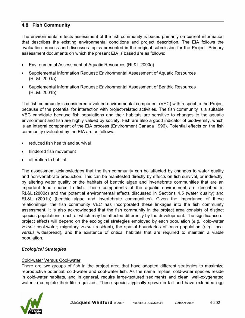
4.8 Fish Community The environmental effects assessment of the fish community is based primarily on current information that describes the existing environmental conditions and project description. The EIA follows the evaluation process and discusses topics presented in the original submission for the Project. Primary assessment documents on which the present EIA is based are as follows: • Environmental Assessment of Aquatic Resources (RL&L 2000a)
• Supplemental Information Request: Environmental Assessment of Aquatic Resources (RL&L 2001a)
• Supplemental Information Request: Environmental Assessment of Benthic Resources (RL&L 2001b)
The fish community is considered a valued environmental component (VEC) with respect to the Project because of the potential for interaction with project-related activities. The fish community is a suitable VEC candidate because fish populations and their habitats are sensitive to changes to the aquatic environment and fish are highly valued by society. Fish are also a good indicator of biodiversity, which is an integral component of the EIA process (Environment Canada 1996). Potential effects on the fish community evaluated by the EIA are as follows: • reduced fish health and survival
• hindered fish movement
• alteration to habitat The assessment acknowledges that the fish community can be affected by changes to water quality and non-vertebrate production. This can be manifested directly by effects on fish survival, or indirectly, by altering water quality or the habitats of benthic algae and invertebrate communities that are an important food source to fish. These components of the aquatic environment are described in RL&L (2000c) and the potential environmental effects discussed in Sections 4.5 (water quality) and RL&L (2001b) (benthic algae and invertebrate communities). Given the importance of these relationships, the fish community VEC has incorporated these linkages into the fish community assessment. It is also acknowledged that the fish community in the project area consists of distinct species populations, each of which may be affected differently by the development. The significance of project effects will depend on the ecological strategies employed by each population (e.g., cold-water versus cool-water; migratory versus resident), the spatial boundaries of each population (e.g., local versus widespread), and the existence of critical habitats that are required to maintain a viable population. Ecological Strategies Cold-water Versus Cool-water There are two groups of fish in the project area that have adopted different strategies to maximize reproductive potential: cold-water and cool-water fish. As the name implies, cold-water species reside in cold-water habitats, and in general, require large-textured sediments and clean, well-oxygenated water to complete their life requisites. These species typically spawn in fall and have extended egg
Jacques Whitford © 2006 PROJECT ABC50541 October 2006 4-202
incubation periods (e.g., mountain whitefish and bull trout). Cool water species tend to be able to tolerate higher water temperatures and are better adapted to inhabit turbid water and cope with high sediment loads. These species typically spawn in spring and have short egg incubation periods (e.g., walleye and longnose sucker). The project area is a transition zone for these two groups of fish. Cool-water species dominate the community, but cold-water fish also reside in the area. For the purposes of this assessment it is assumed that the fish community in the project area is comprised of both cold-water and cool-water fish species. Migratory Versus Resident Fish that reside in north temperate climates use migration (movement) as a strategy to cope with harsh and unpredictable environments. Migration is defined as movements resulting in alterations between two or more separate habitats occurring with regular periodicity (seasonal or annual) and involving a large fraction of the population (Northcote 1998). The patterns of movement can vary between species and even between groups within the same population (Northcote 1978). Fish residing in the Peace River use movement as a strategy to access important habitats (Nelson and Paetz 1992; Mill et al. 1997); however, certain species are known to undertake extensive movements (migratory), whereas others undertake only local movements (resident). For the purposes of this assessment it is assumed that the fish community in the project area is composed of both migratory (e.g., goldeye) and resident (e.g., burbot) fish. Important Habitat Fish habitat is defined as any spawning grounds and nursery, rearing, food supply, and migration areas on which fish depend directly or indirectly to carry out their life processes (DFO 1998). An important distinction is made for critical habitat, which is defined as a discrete area of habitat that is essential for the maintenance of a self-sustaining, fish population. Removal of critical habitat from production, by alteration, destruction or elimination of access, would severely reduce the viability of the population. Fish habitat is present throughout the project area, but baseline investigations (fish and habitat, fish movements) did not identify critical habitats potentially affected by the proposed development. Important habitats were recorded in the project area. An important habitat represents high quality habitat that has the potential to be used as critical habitat. It differs from critical habitat in that it is not a discrete area that is known to be used by fish. For the purposes of this assessment, it is assumed that the project area contains important fish habitat required for the maintenance of fish populations recorded in the project area. Fish Community Groups As stated previously, the fish community will be used as the VEC for this assessment, but project effects will vary depending on the species and population characteristics. To properly evaluate project effects, or risk to a specific species population, it is necessary to categorize each species population of the fish community into representative groups based on these characteristics. The following groups will be used as a basis for the environmental effects assessment: Migratory Group Migratory refers to a strategy that requires extensive movements outside the project area to access one or more critical habitats. Based on this strategy, it is assumed that migratory fish belong to biological populations that are widely distributed in the Peace River and the population boundary is not limited to
Jacques Whitford © 2006 PROJECT ABC50541 October 2006 4-203
the project area. Fish populations recorded in the project area that are assumed to use this strategy include the following cool-water species: • goldeye
• flathead chub Resident Group Resident refers to a strategy that entails local movements within and adjacent to the project area to access one or more critical habitats. Based on this strategy, it is assumed that the boundary of the biological population is limited to the vicinity of the project area, but similar populations reside upstream and downstream from the project area. Cool-water species populations recorded in the project area represented by this group include: • burbot
• northern pike
• longnose sucker
• white sucker
• walleye
• all small-fish species (cyprinids and sculpins) Transitory Group Transitory refers to fish that occur in the project area that have undertaken dispersal movements from outside locations. Due to limitations of the project area habitat, these fish are not part of viable, self-sustaining populations. In addition, these fish are not an essential reproductive component of the population from which they originated. Transitory populations are characterized by four factors as follows:
• The absence of important habitats in the project area preclude establishment of a self sustaining population.
• The fish account for a small fraction of the parent population from which they originated.
• The population persists in the project area due to recruitment from the parent population; not from natural reproduction from within the project area.
• These fish use habitats in the project area on a seasonal basis and either die when habitat conditions become suboptimal, or they emigrate from the project area (upstream or downstream).
The two species that comprise this group, which are cold-water species, are: • bull trout
• mountain whitefish
Jacques Whitford © 2006 PROJECT ABC50541 October 2006 4-204
It should be noted that bull trout has been identified as a species of concern in the province of Alberta (Berry 1994; Bull Trout Task Force 1995); therefore, this species likely has a higher social value than others recorded in the project area. From an ecological perspective, bull trout are a very small component of the project area fish community, and as such, this species was not given a high priority by the assessment (i.e., it was not used as a specific VEC). Unique Group A population in this group is defined as a viable, spatially distinct, resident species population that is not widespread either upstream or downstream from the project area. Because the population is resident and spatially distinct, project effects have the potential to adversely affect the species distribution within the Peace River basin. The single species population that comprises this group is fathead minnow. Incidental Group The incidental group encompasses all remaining species having the potential to occur in the project area that are not assigned to migratory, resident, transitory or unique. Fish of these species are present in the project area in low numbers, are not part of a viable population, and provide no reproductive contribution to parent populations. They differ from species populations in the transitory group because their occurrence in the project area is rare and sporadic. Species in this group are as follows: • Arctic grayling
• rainbow trout
• lake whitefish
• kokanee
• northern pikeminnow 4.8.1 Boundaries 4.8.1.1 Spatial Boundaries The spatial boundaries of the Project have been delineated to reflect local and regional effects (Figure 4.8-1). This is required to address cumulative effects and differences in fish population boundaries (e.g., resident versus migratory). The term “local study area” refers to the immediate-effects zone of the Project as follows: • 36 km of the mainstem Peace River from 10 km downstream from the headworks to the upstream
extent of the headpond (26 km)
• the lowermost 1000 m of Ksituan River (section that will be inundated by the headpond)
• the lowermost 300 m of Hines Creek (section that encompasses the road crossing location downstream to the confluence with Peace River)
• the lowermost 300 m of Dunvegan Creek (section that encompasses the road and transmission line crossing location downstream to the confluence with Peace River)
Jacques Whitford © 2006 PROJECT ABC50541 October 2006 4-205
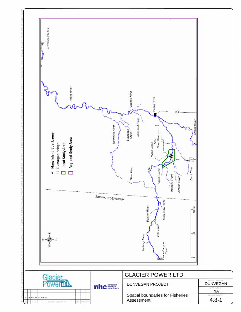
GLACIER POWER LTD.
4.8-1
DUNVEGAN PROJECT Spatial boundaries for Fisheries Assessment
NA
DUNVEGAN
A 06 08 22 FOR E.I.A.

The “regional study area” (RSA) refers to the mainstem Peace River from the Peace Canyon Dam to Vermilion Chutes, which is a distance of approximately 865 km, and all major tributaries entering the Peace River within this zone. These spatial limits are used because they delineate the maximum distribution of distinct fish populations that are potentially influenced by the Project. The regional boundary encompasses all of the migratory fish population boundaries and all the boundaries of resident fish populations outside the local boundary. 4.8.1.2 Population Boundaries In general, a fish population can be defined as a group of individuals of the same species that live at the same point in time in a geographically defined area (Wootton 1990). For populations residing in the project area, this geographic boundary can be defined as the mainstem river and its tributaries upstream from Vermilion Chutes and downstream from the Peace Canyon Dam (Mill et al. 1997). This population boundary reflects the regional boundary defined in Section 4.8.1.1. The population within this geographic boundary, however, consists of several stocks or sub-populations that are defined biologically. A biological population is defined as a collection of individuals that make up a gene pool that has continuity in time because of reproductive activities within the population (MacLean and Evans 1981). The Peace River supports several discrete biological populations. The spatial boundaries of these biological populations can be regional or local, depending on the movement strategy and habitat requirements of the population. It is assumed that the fish community in the project area consists of species populations that have local and regional boundaries. Resident fish populations within the project area demonstrate local boundaries consistent with the definition presented in Section 4.8.1.1. However, a fundamental approach of the effects assessment is the need to acknowledge the potential presence of resident fish populations immediately upstream or downstream from the local project boundary. These biological populations may or may not be affected by the Project. This approach also is applied to the other fish groups that include migratory, transitory and unique species populations. 4.8.1.3 Temporal Boundaries The temporal boundary of the Project has been divided into the following: • pre-development: 1968 to 2007 (38 years)
• construction: April 2008 to September 2011 (3.5 years)
• operations: September 2011 to 2111 (100 years)
• decommissioning: infrastructure: 2111 (9 months) and headpond: 2112 to 2142 (30 years) 4.8.1.4 Administrative Boundaries Much of the information used in the assessment was collected from federal and provincial government files and reports. Industry data from BC Hydro and Diashowa-Marubeni International Ltd. are also incorporated into the assessment.
Jacques Whitford © 2006 PROJECT ABC50541 October 2006 4-207
4.8.1.5 Technical Boundaries Baseline information and data used to evaluate project effects on the aquatic environment were generated from a variety of sources. Site-specific fish information was collected for the project area during field studies conducted in 1999 and from 2001 to 2005. Regional fisheries data from government and industry also were used in the assessment. The majority of the information is quantitative and of good quality. 4.8.2 Description of Existing Conditions The baseline data used to describe the existing conditions in the Dunvegan Hydroelectric project area are primarily from technical reports that describe fish community characteristics prepared specifically for the Project as follows: • 1999 Fish and habitat inventory comprehensive report (RL&L 2000b)
• Water quality, benthic algae, and benthic macroinvertebrate information base comprehensive report (RL&L 2000c)
• Habitat losses and gains in the headpond (MMA 2001)
• 2002–2003 Fish movement study (Mainstream 2004a)
• 2004 Baseline fish inventory study (Mainstream 2006a)
• 2004–2005 Fish movement study (Mainstream 2006b)
• Habitat no net loss plan (Mainstream 2006c) Where appropriate, information from other technical sources were reviewed and included in the assessment. 4.8.2.1 General Characteristics The characteristics of the Peace River and its tributaries affect the existing fish species assemblage and fish abundance in the project area. The following are factors that have a major influence on the fish populations and their habitats. 4.8.2.1.1 Flow Regulation The Peace River is subjected to flow regulation by the Bennett Dam in British Columbia. Peak annual flows are reduced while there are large diurnal fluctuations in flow. According to Prowse and Conly (1996) flow regulation of the Peace River has affected the fish community as follows: • an altered temperature regime that has permitted cold-water species to extend their downstream
limit of distribution
• a reduced capacity to transport sediments, which has caused a narrowing of the river channel and altered habitats
Jacques Whitford © 2006 PROJECT ABC50541 October 2006 4-208
• an ice regime that severely restricts the availability of overwintering habitat
• diurnal fluctuations in water level that reduces the availability of habitats 4.8.2.1.2 Sediment Load The Peace River has a high sediment load (MMA 2000a). Post-Bennett Dam suspended sediment concentrations in the project area have ranged as high as 4 730 mg/L. The associated daily suspended sediment load was estimated to be 1.3 Mt/d. Suspended sediment concentrations (and turbidity levels) tend to be highest in spring and decline throughout summer and fall. These constituents regularly exceed the Canadian Water Quality Guidelines (CWQG) criteria for Aquatic Life, particularly in spring. There is a generally accepted body of literature that demonstrates the severity of effects of suspended solids on fish increases as a function of both sediment concentration and duration of exposure (Anderson et al. 1995; Newcombe and Jensen 1996). High suspended sediment loads can also affect other aquatic biota; for example, high total suspended sediments (TSS) levels can result in abrasion of benthic algal communities and decreased light penetration, both of which result in reduced primary productivity (Stevenson et al. 1996). The sediment concentration and duration of exposure in the Peace River presently exceed the threshold deemed to cause adverse effects. 4.8.2.1.3 Tributaries The tributaries flowing into Peace River in the project area have been influenced by land-use activities such as agriculture and logging. Stream flow in the tributaries is highly variable, with extreme discharge occurring in spring or during large rainfall events, followed by subsequent intermittent or zero flow conditions. This discharge regime has reduced the quality and availability of fish habitats. These effects have influenced the structure of the fish community that resides in the project area. Fish populations that require tributary habitats for spawning and rearing purposes during summer and fall are severely restricted. Similarly, the tributaries cannot provide overwintering habitat for fish or areas of refuge from adverse conditions in the mainstem Peace River. 4.8.2.2 Benthic Resources As identified above, benthic algae and invertebrate communities are an important food source to fish and, as such, they have been included in the description and assessment of project effects on the fish community. From past studies of benthic communities in the Peace River in Alberta, it can be concluded that the benthic invertebrate community near Dunvegan is characteristically different (i.e., relatively higher numbers of bristle worms [Enchytraeidae, Naididae, Tubificidae], and midges [Orthocladiinae, Diamesinae]) from other reaches of the Peace River, likely as a function of the habitat characteristics that define this area (i.e., water velocity, suspended sediment load, and substrate particle size). The project area contains two general types of benthic algae and invertebrate communities: hard substrate communities associated with swift water and large particle sizes, and soft-substrate communities associated with slower water velocity and small particle sizes. Due to the high water velocities in the main channel, this part of the aquatic habitat likely supports hard-substrate communities whereas the soft-substrate communities are likely to be restricted to habitats in low velocity areas found in near-
Jacques Whitford © 2006 PROJECT ABC50541 October 2006 4-209
shore areas. These latter habitats currently account for a relatively small percentage of the total aquatic habitat within the project area. Pre-development benthic algae and invertebrate communities in the project area are currently influenced by several factors that limit their productive capacity. Some important factors include the operational regime of the Bennett Dam that causes dewatering on a seasonal and daily basis, and high sediment loads that cause reduced light penetration, scour, and sediment deposition. 4.8.2.2.1 Benthic Algae Benthic algae are an important component of the microflora (algae, bacteria, fungi, and their secretions) associated with solid surfaces of aquatic systems (Wetzel 1983; Lock et al. 1984). Benthic algae are primary producers that are an important component of the aquatic food chain. Site specific studies of the benthic algal community were not completed in the local study area (LSA); however, benthic algal community studies have been conducted on other large northern Alberta rivers. In a section of the Athabasca River near Fort McKay, a river section that has similar habitat features to that of Peace River near the project area, diatoms (Bacillariophyta) accounted for 61 percent of the taxonomic groups that were encountered during four sampling seasons. Green algae (Chlorophyta) were second (18 percent) in overall abundance; however, blue-green algae (Cyanobacteria) generally dominated the benthic algal community in fall and winter. Standing crop measurements (number of cells/m2 and mg of organic matter/m2) indicated highest benthic algal productivity in January, June, and September-October (McCart et al. 1977). Chlorophyll a is a photosynthesizing pigment found in most algae and its concentration generally is correlated to algal biomass (i.e., an estimate of the amount of live algae or standing crop). Planktonic chlorophyll a is an estimate of algal abundance within the water column, whereas benthic chlorophyll a is a measure of algae attached to bottom substrates. For the purposes of this discussion, planktonic chlorophyll is included with benthic chlorophyll. Planktonic concentrations of chlorophyll a at Dunvegan were examined in 1988 and 1989 by Shaw et al. (1990). Concentrations varied from 0.6 (in February) to 15.7 mg/m3 (in May). In general, mean planktonic chlorophyll a concentrations of the Peace River mainstem between the British Columbia–Alberta border to upstream from the Whitemud River were near 2 mg/m3. Planktonic chlorophyll a concentrations tend to be lowest in winter and highest in late summer. Long-term monitoring of Peace River planktonic concentrations of chlorophyll a was conducted at Fort Vermilion (NAQUADAT, Damayo and Hunt 1975; RL&L 2000a). Between June 1989 and December 1998, the mean concentration at this site was 0.68 mg/m3. Concentrations varied from 0.20 mg/m3 (in January to March) to 5.4 mg/m3 (in July). Planktonic concentrations were generally lowest in winter and highest in summer (late July to early September). This is to be expected because of higher biological productivity in late summer common to most aquatic systems at temperate latitudes. Planktonic concentrations of chlorophyll a in the Peace River are comparable to concentrations measured in other rivers in northern Alberta. Upstream from the City of Edmonton in the North Saskatchewan River, mean concentrations varied from 0.21 to 1.62 mg/m3 among nine sites sampled in 1985 and 1986 (Shaw et al. 1994); municipal wastewaters markedly affected downstream
Jacques Whitford © 2006 PROJECT ABC50541 October 2006 4-210
chlorophyll a concentrations. Between 1984 and 1986, chlorophyll a concentrations in the upper reaches of the Athabasca River (at the Town of Hinton and up to 75 km downstream) were generally between 0.20 and 0.90 mg/m3 (Anderson 1989). Anderson (1989), however, encountered concentrations as high as 17.0 mg/m3, which were attributed to enrichment effects from the combined Hinton-pulp mill effluent. During winter synoptic surveys conducted in the early 1990s, concentrations of planktonic chlorophyll a in the Athabasca River varied from 0.1 to 1.4 mg/m3 among 16 sampling sites between Hinton and Lake Athabasca (Noton and Saffran 1995). Benthic concentrations of chlorophyll a were measured at Dunvegan in 1988 by Shaw et al. (1990). Concentrations varied from 2.1 to 99.1 mg/m2 on 21 July 1988 and 22 August 1988, respectively. Four samples were collected between May and September 1988, with an overall average of 40.1 mg/m2. Benthic concentrations of chlorophyll a in the Peace River are similar to other rivers in northern Alberta with local variation usually associated with effluent outfalls. For example, concentrations of the North Saskatchewan River varied from 1.0 to 50 mg/m2; downstream from Edmonton from the headwaters to Devon. Values increased sharply to a maximum of 500 mg/m2 due to nutrient enrichment effects from municipal wastewaters downstream from the city (Shaw et al. 1994). From 1984 to 1986, concentrations of benthic chlorophyll a in the Athabasca River, upstream from the combined Town of Hinton-pulp mill effluent outfall, were less than 15 mg/m2, whereas all concentrations downstream were greater than 30 mg/m2 (Anderson 1989). The benthic algal community in Peace River at Dunvegan is typical of large turbid rivers. The ecology of the benthic algae in this area is influenced by discharge, velocity, and water quality parameters such as suspended solids, turbidity, and nutrients. Scour caused by high suspended sediment concentrations, and limited photosynthesis caused by high turbidity likely reduce the productive capacity of this community. Seasonal patterns in the species composition and standing crop of the benthic algal community also reflect large seasonal differences in river discharge. Furthermore, frequent water level fluctuations resulting from operation of Bennett Dam are detrimental to benthic algae in near-shore areas because of stranding and desiccation (Cushman 1985; RL&L 1995). As such, productive capacity of the benthic algal community in Peace River at Dunvegan is limited by a combination of natural conditions and Bennett Dam operations. 4.8.2.2.2 Benthic Invertebrates Benthic invertebrate studies have been conducted on Peace River and near Dunvegan (Shaw et al. 1990; Monenco Consultants Ltd. 1992a, b; Cash et al. 1996). These studies have shown that the macroinvertebrate community of Peace River in the project area consists primarily of bristle worms (Oligochaeta), midge larvae (Chironomidae), and roundworms (Nematoda); a small portion of the community is composed of mayflies (Ephemeroptera) and stoneflies (Plecoptera). Distinct seasonal changes in the community structure were not apparent, although numbers tended to be lower during spring and higher during autumn. The low numbers of benthic invertebrates recorded in Peace River near the project area are typical of large rivers that have unstable silts and sands that overlie compacted gravel and cobble materials (MMA, 2000). Similar to the benthic algae, the benthic invertebrate community is adversely affected by high suspended sediment concentrations and variable discharge. High suspended sediment levels can cause sedimentation, thereby limiting benthic invertebrate productivity. Similar to effects on benthic
Jacques Whitford © 2006 PROJECT ABC50541 October 2006 4-211
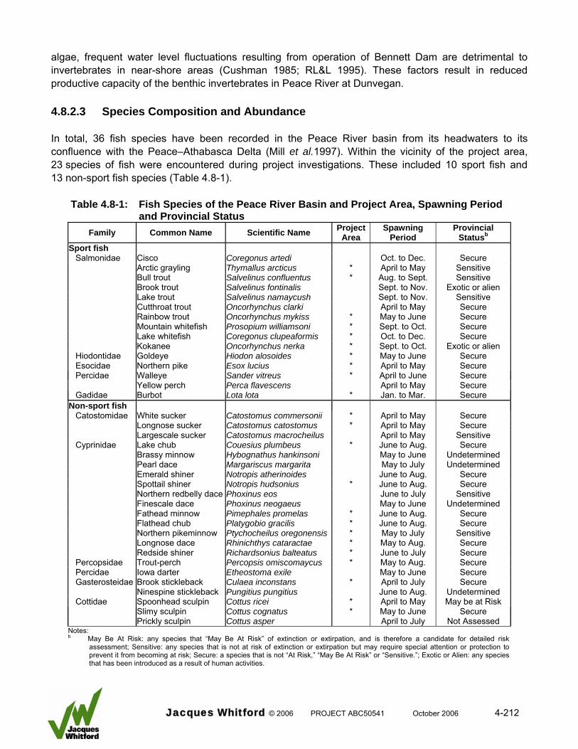
algae, frequent water level fluctuations resulting from operation of Bennett Dam are detrimental to invertebrates in near-shore areas (Cushman 1985; RL&L 1995). These factors result in reduced productive capacity of the benthic invertebrates in Peace River at Dunvegan. 4.8.2.3 Species Composition and Abundance In total, 36 fish species have been recorded in the Peace River basin from its headwaters to its confluence with the Peace–Athabasca Delta (Mill et al.1997). Within the vicinity of the project area, 23 species of fish were encountered during project investigations. These included 10 sport fish and 13 non-sport fish species (Table 4.8-1).
Table 4.8-1: Fish Species of the Peace River Basin and Project Area, Spawning Period and Provincial Status
Family Common Name Scientific Name Project Area
Spawning Period
Provincial Statusb
Sport fish Salmonidae Cisco Coregonus artedi Oct. to Dec. Secure Arctic grayling Thymallus arcticus * April to May Sensitive Bull trout Salvelinus confluentus * Aug. to Sept. Sensitive Brook trout Salvelinus fontinalis Sept. to Nov. Exotic or alien Lake trout Salvelinus namaycush Sept. to Nov. Sensitive Cutthroat trout Oncorhynchus clarki April to May Secure Rainbow trout Oncorhynchus mykiss * May to June Secure Mountain whitefish Prosopium williamsoni * Sept. to Oct. Secure Lake whitefish Coregonus clupeaformis * Oct. to Dec. Secure Kokanee Oncorhynchus nerka * Sept. to Oct. Exotic or alien Hiodontidae Goldeye Hiodon alosoides * May to June Secure Esocidae Northern pike Esox lucius * April to May Secure Percidae Walleye Sander vitreus * April to June Secure Yellow perch Perca flavescens April to May Secure Gadidae Burbot Lota lota * Jan. to Mar. Secure
Non-sport fish Catostomidae White sucker Catostomus commersonii * April to May Secure Longnose sucker Catostomus catostomus * April to May Secure Largescale sucker Catostomus macrocheilus April to May Sensitive Cyprinidae Lake chub Couesius plumbeus * June to Aug. Secure Brassy minnow Hybognathus hankinsoni May to June Undetermined Pearl dace Margariscus margarita May to July Undetermined Emerald shiner Notropis atherinoides June to Aug. Secure Spottail shiner Notropis hudsonius * June to Aug. Secure Northern redbelly dace Phoxinus eos June to July Sensitive Finescale dace Phoxinus neogaeus May to June Undetermined Fathead minnow Pimephales promelas * June to Aug. Secure Flathead chub Platygobio gracilis * June to Aug. Secure Northern pikeminnow Ptychocheilus oregonensis * May to July Sensitive Longnose dace Rhinichthys cataractae * May to Aug. Secure Redside shiner Richardsonius balteatus * June to July Secure Percopsidae Trout-perch Percopsis omiscomaycus * May to Aug. Secure Percidae Iowa darter Etheostoma exile May to June Secure Gasterosteidae Brook stickleback Culaea inconstans * April to July Secure Ninespine stickleback Pungitius pungitius June to Aug. Undetermined Cottidae Spoonhead sculpin Cottus ricei * April to May May be at Risk Slimy sculpin Cottus cognatus * May to June Secure Prickly sculpin Cottus asper April to July Not Assessed
Notes: b May Be At Risk: any species that “May Be At Risk” of extinction or extirpation, and is therefore a candidate for detailed risk
assessment; Sensitive: any species that is not at risk of extinction or extirpation but may require special attention or protection to prevent it from becoming at risk; Secure: a species that is not “At Risk,” “May Be At Risk” or “Sensitive.”; Exotic or Alien: any species that has been introduced as a result of human activities.
Jacques Whitford © 2006 PROJECT ABC50541 October 2006 4-212
None of the 36 species known to occur in the Peace River drainage within Alberta are listed under the Species at Risk Act (SARA) Public Registry (SARA 2006, Internet site). The Alberta Government, Sustainable Resource Development, Alberta Species at Risk Program provides a status listing of each fish species found in the province (ASRD 2000). The majority of fish species recorded in the study area (18 of 23) are considered secure (Table 4.8.1), while one species is categorized as alien or exotic (kokanee). Three species are designated as sensitive: bull trout, Arctic grayling, and northern pike minnow. Individuals of all three originate from viable populations upstream from the Alberta–British Columbia boundary. Spoonhead sculpin is the only species that received a “May be at Risk” designation under the provincial listing. Only one unique species population, fathead minnow, was recorded in the project area downstream from the proposed facility. The species is widespread in Alberta river basins south of the Peace River and is present in the Slave River drainage, but it has been identified only from one location in the Peace River system: One Island Lake near Tupper, British Columbia (Smith and Lamb [1976] in Nelson and Paetz 1992). Sixteen fathead minnows were recorded in the mainstem Peace River during the 1999 investigation. These fish likely originated from nearby tributaries. In terms of overall fish abundance in the project area, fish numbers are low. Sampling for large-sized fish (greater than 200 mm length) using boat electrofishing, set lines, and trap nets established that the majority of fish consisted of non-sport fish species. The numerically dominant species were longnose sucker and flathead chub. Sport fish were much less abundant than non-sport fish in the large-fish sample. The dominant species in this group were mountain whitefish, walleye, burbot, and goldeye. During small fish sampling using beach seining and backpack electrofishing, 11 non-sport fish and 4 sport fish species were recorded. Most of the sample (99 percent) consisted of non-sport fish, with lake chub and longnose sucker being the dominant species. The remaining non-sport fish species captured included flathead chub, longnose dace, white sucker, redside shiner, spoonhead sculpin, slimy sculpin, spottail shiner, trout-perch, and fathead minnow. Sport fish encountered in very low numbers included mountain whitefish, bull trout, burbot, and kokanee. All of the major sport and non-sport fish species were recorded in each of the three study zones sampled in the project area (upstream, headpond, and downstream). In general, catch rates were similar among each of the three zones, but the abundance of some species varied between seasons. In particular goldeye and flathead chub were most numerous in spring, but were largely absent during fall. This change in abundance likely reflected movements of fish through the project area (goldeye) or may have reflected changes in gear capture efficiency (flathead chub). During sampling of upper and lower tributary sections, one sport fish and seven non-sport fish species were captured. Most fish were recorded in the lower sites; lake chub was the dominant species. Other non-sport fish species captured in the tributaries included, in decreasing order of abundance, longnose sucker, longnose dace, white sucker, flathead chub, spottail shiner, and brook stickleback. Burbot was the only sport fish recorded in project area tributaries.
Jacques Whitford © 2006 PROJECT ABC50541 October 2006 4-213
4.8.2.4 Distribution Section 4.2.5 in Mainstream (2006a) provides an overview of fish distribution. Information from the present investigation, as well as from other studies, indicates that the project area is a transition zone between cold water and cool water fish communities. The fish community in the project area is dominated by cool water species that are adapted to high water turbidity (e.g., goldeye, walleye, northern pike and longnose sucker), but cold water species (mountain whitefish and bull trout) also are present. The cold water species populations mountain whitefish and bull trout are at the downstream extent of their range in the project area due to a combination of factors that include exceedance of critical temperature thresholds and marginal quality habitat that severely limit the productive capacity of local fish (e.g., spawning habitat). 4.8.2.5 Life History The majority of sport fish in the project area are adults. The only exceptions are mountain whitefish (juveniles, adults, and few young-of-the-year fish) and bull trout (mainly subadults). Seasonal changes in the size distribution of mountain whitefish in the project area in 1999 and 2004 indicated that these fish likely dispersed from upstream areas of the Peace River. In contrast to sport fish, all life stages of several non-sport fish species, including longnose sucker, flathead chub and white sucker, are well represented. Most non-sport fish in tributaries consist of young-of-the-year and juvenile fish, and cyprinids of all life stages. Adult non-sport fish present in the tributaries include spawning longnose and white suckers. The majority of fish species in the project area are spring or early summer spawners that have short egg incubation periods. This life history strategy maximizes the probability of reproductive success by taking advantage of suitable water conditions. Burbot is the only species that spawns during winter (January or February), but the egg incubation period is also brief. The only two species that are fall spawners with an extended egg incubation period are bull trout and mountain whitefish. This strategy is not appropriate for the project area due to the unfavourable sediment loads and ice conditions, which minimize the probability of reproductive success. 4.8.2.6 Movements An overview of fish movements that are expected to occur in the project area are presented in Section 4.2.5.2 of Mainstream (2006a) and summarized in this section. The information presented in this section is based on site-specific data that include: seasonal catch rates, floy tag returns, and radio-telemetry data, information from other studies, and the author’s knowledge of the Peace River fish species populations. Goldeye that occur in the project area are part of a migratory population. Radio-telemetry movement studies from 2002 to 2005 indicate that goldeye overwinter in the Peace River downstream from the Smoky River confluence. A portion of the population migrates upstream into and through the project area to spawn and feed. Other goldeye remain downstream from the project area during their annual migration cycle. Differences in seasonal abundance documented during fish inventories in 1999 and 2004 support the radio telemetry results.
Jacques Whitford © 2006 PROJECT ABC50541 October 2006 4-214

Other species populations in the project area are non-migratory. Radio telemetry data for burbot, walleye, and longnose sucker indicate that most fish undertake only local movements within a discrete section of the Peace River between the confluence of the Smoky River and the Many Islands area. Seasonal movement patterns were documented, but distances traveled were generally short (less than 20 km). Movement data for walleye, burbot, and longnose suckers indicate that at least a portion of each population spawns outside of the project area. It is likely that most populations of other large-fish species not examined using radio-telemetry are non-migratory. Seasonal differences in abundance of flathead chub documented during fish inventories indicate that this population may be migratory. It is unclear whether the results were representative of a migratory population or whether seasonal differences in abundance were an artefact of changes in fish capture efficiency. Low numbers of adult mountain whitefish and bull trout precluded an assessment of movements by of these populations in the project area. Studies have documented viable populations of both species in the Peace River in British Columbia (Mainstream and Gazey 2004) and the scarcity of these species in the Peace River downstream from the project area (Hildebrand 1990). Seasonal changes in size distribution of mountain whitefish and the presence of primarily subadult bull trout suggest that fish of these species disperse into the project area from upstream populations. These fish either die or move back upstream to complete their life requisites. Movement data were not collected for small-fish species recorded in the project area, but it is likely that these species populations are resident given their small size. A study completed by Gibbons et al. (1996) documented very little movement by spoonhead sculpin and lake chub in the upper Athabasca River. This provides evidence that small-fish species undertake only restricted movements to complete their life requisites. For most fish species expected to occur in the project area, upstream movements commence in April and end in October. Downstream movements generally occur from August to November. During the months of December to March, fish tend to be stationary. Within this general pattern there are species-specific movement strategies that are illustrated in Table 4.8-2. The only strong exception to the general pattern described above is burbot. The project area population completes its annual movements in winter. Burbot move downstream in December and January then undertake upstream movements in February and March; all under ice. For the remainder of the year burbot in the project area tend to be stationary.
Jacques Whitford © 2006 PROJECT ABC50541 October 2006 4-215
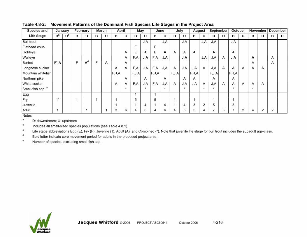
Table 4.8-2: Movement Patterns of the Dominant Fish Species Life Stages in the Project Area January February March April May June July August September October November DecemberSpecies and
Life Stage Da Ua D U D U D U D U D U D U D U D U D U D U D U Bull trout J,A J,A J,A J,A J,A J,A Flathead chub F F Goldeye A E A E A A A A A A Walleye A F,A J,A F,A J,A J,A J,A J,A A J,A A A Burbot Fc,A F Ad F A A A A Longnose sucker A A F,A J,A F,A J,A A J,A J,A A J,A A A A A A Mountain whitefish F,J,A F,J,A F,J,A F,J,A F,J,A F,J,A F,J,A Northern pike A A A A A A A White sucker A A F,A J,A F,A J,A A J,A J,A A J,A A A A A A Small-fish spp. b * * * * * * * * Egg 1 1 Fry 1e 1 1 1 5 5 1 1 1 1 Juvenile 1 1 4 1 4 1 4 3 2 5 3 Adult 1 1 1 3 6 4 6 4 6 4 6 5 4 7 3 7 2 4 2 2 Notes: a D: downstream; U: upstream b Includes all small-sized species populations (see Table 4.8.1). c Life stage abbreviations Egg (E), Fry (F), Juvenile (J), Adult (A), and Combined (*). Note that juvenile life stage for bull trout includes the subadult age-class. d Bold letter indicate core movement period for adults in the proposed project area. e Number of species, excluding small-fish spp.
Jacques Whitford © 2006 PROJECT ABC50541 October 2006 4-216
4.8.2.7 Health and Survival A review of the literature pertaining to fish health in Peace River indicates that levels of contamination are low, particularly compared to other systems in Canada and elsewhere in the world (Wrona et al. 1996; Stanley 1997). In general, contaminant loads in fish conform to federal guidelines. Furthermore, there is no fish consumption advisory in effect for the Peace River between Many Islands (upstream from the project area) and the confluence with Smoky River (ASRD 2006, Internet site). In a review of mercury concentration in fish residing in the Peace River of British Columbia, Triton (1992) reported that mercury levels in several species (rainbow trout, lake trout and burbot) were below the federal guidelines, although elevated levels were identified in some larger bull trout. 4.8.2.8 Habitat Fish habitats in the project area were documented in terms of their quality and quantity during the 1999 investigation (RL&L 2000b). The information was supplemented by additional field investigations completed in 2000 that examined specific habitat sites within the project area (Glacier 2001, MMA 2001) and comparisons to other studies (Mainstream 2006a). This work was followed by a detailed evaluation of habitat losses and gains in preparation for a No Net Loss Habitat Plan for the Project (Mainstream 2006c). The survey methods used during each study are described in the respective documents. The following summarizes the general findings. 4.8.2.8.1 Mainstem Peace River The results of field investigations show that fish habitat in the Peace River in the project area is uniform and exhibits low complexity. In general, riverbank mesohabitats provide limited amounts of cover for fish, and unique instream mesohabitats are restricted in distribution. Backwaters that provide protected, low velocity areas for fish, although present, are not abundant. Shoal and riffle or rapid habitats that could potentially be used for feeding and spawning purposes are present, but they provide small amounts of habitat relative to other lower quality habitats such as deep exposed runs. No protected snyes (side channels) are present. The mainstem Peace River provides limited amounts of high-quality fish habitat. The channel is relatively shallow throughout, which limits its potential as overwintering habitat, and water velocities are generally high. There is a paucity of instream cover, as a result of smooth riverbanks and channel bottom (caused by embedded large-textured materials). As such, habitats that provide refuge from high water velocities are not abundant. This situation is exacerbated by daily fluctuations in the flow regime that further reduce the quality of available habitat. 4.8.2.8.2 Tributaries Tributaries in the project area are characterized by variable flows. In summer and fall habitat is frequently limited to isolated pools with no surface connection to the mainstem Peace River. Channel characteristics of project area tributaries indicate that they are subject to significant flow events and extensive bedload movement. Stream channels are laterally unstable as evidenced by extensive bank erosion. Due to low (spring) and negligible flows (summer and fall), an absence of deep-water habitat capable of supporting overwintering fish, and the prevalence of fine substrates, the tributaries provided
Jacques Whitford © 2006 PROJECT ABC50541 October 2006 4-217
poor habitat for most fish species. Resident stream populations were not recorded and the tributaries had limited value to sport and non-sport fish populations originating from in the mainstem Peace River. However, the tributaries did provide seasonal habitat for cyprinid and sucker species. 4.8.2.8.3 Important Habitats Two important habitats were found in the project area during the 1999 and 2004 investigations. A walleye spawning site was identified at a shoal within the proposed headpond area. A small number of fish (9) in spawning condition and walleye eggs were recorded at the site in 1999. The shoal consisted of unconsolidated gravels and cobbles that were not unfilled by sediments. Walleye in spawning condition (9 fish) were recorded at the site again in 2004. Although used for spawning, the shoal is subjected to dewatering due to flow regulation. In 1999, the shoal and incubating walleye eggs were dewatered. In 1999, a northern pike spawning area was in the proposed headpond area adjacent to a nonactive side channel of the Peace River. Northern pike appeared to be using submerged shoreline vegetation as spawning substrate. Flow regulation caused the site to dewater shortly after it was identified. A subsequent survey in 2004 established that the site was completely destroyed by ice scour caused by the unconsolidated ice sheet during winter of 2003–04. Longnose sucker, white sucker, and a number of cyprinid species used tributary habitats in the project area for spawning and rearing. These included areas in Hines and Dunvegan Creeks and the Ksituan River. 4.8.2.8.4 Habitat Quantity and Quality Fish habitat quantity and quality were quantified in order to evaluate habitat losses and gains associated with the Project using the Habitat Suitability Matrix protocol (Mainstream 2006c). In the headpond, the majority of existing instream habitats consist of deep run (93 percent by area) interspersed with small, discrete units of shoal (2 percent) and backwater (2 percent) habitats. Banks are dominated by erosional habitats dominated by sands (58 percent), armoured habitats that consist of rock (34 percent), and depositional habitats dominated by sands (6 percent). Habitat suitability ratings for individual species and life stages indicate that habitat quality within the project area is low. The exceptions are Shoal and Backwater habitats, which have a moderate or high habitat suitability rating; however, these specific habitats are not abundant. The evaluation established that a small number of habitat types dominate in the project area and these habitats are low quality, which confirms the findings of the field investigations completed in 1999 and 2004. 4.8.2.8.5 Habitat Distribution The majority of habitats required by fish species expected to occur in the project area exhibit widespread distributions (Table 4.8.3).
Jacques Whitford © 2006 PROJECT ABC50541 October 2006 4-218
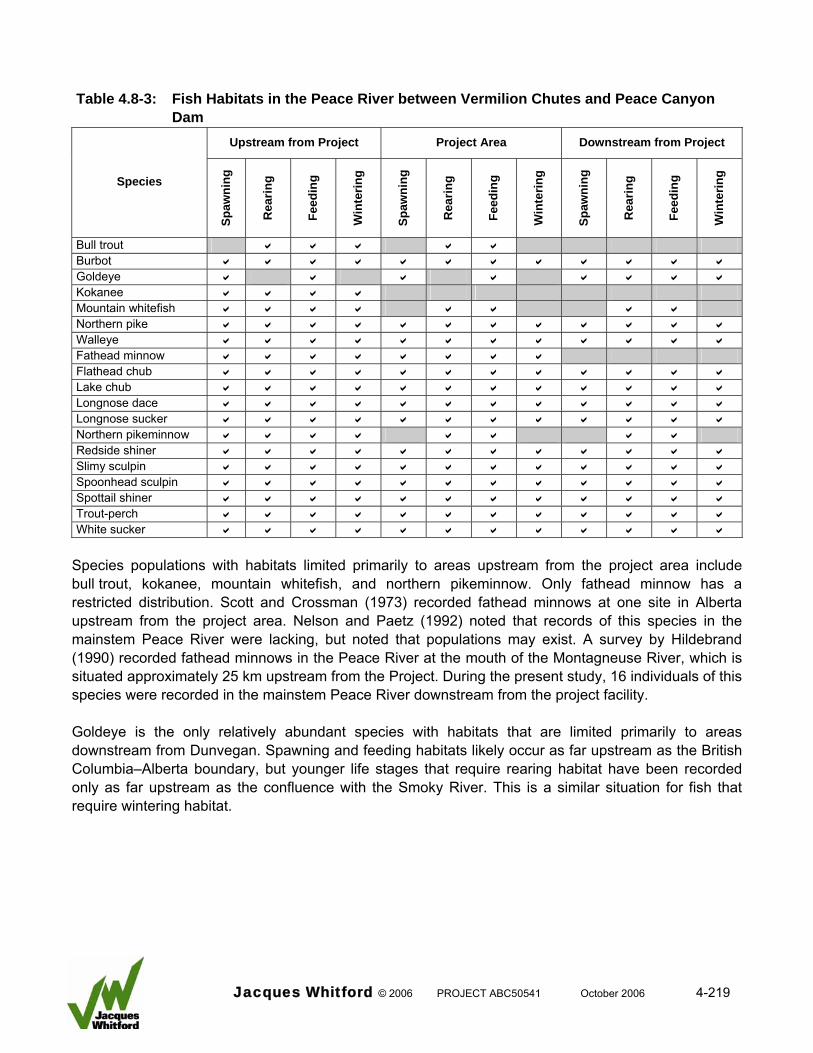
Table 4.8-3: Fish Habitats in the Peace River between Vermilion Chutes and Peace Canyon
Dam Upstream from Project Project Area Downstream from Project
Species
Spaw
ning
Rea
ring
Feed
ing
Win
terin
g
Spaw
ning
Rea
ring
Feed
ing
Win
terin
g
Spaw
ning
Rea
ring
Feed
ing
Win
terin
g
Bull trout a a a a a Burbot a a a a a a a a a a a a Goldeye a a a a a a a a Kokanee a a a a Mountain whitefish a a a a a a a a Northern pike a a a a a a a a a a a a Walleye a a a a a a a a a a a a Fathead minnow a a a a a a a a Flathead chub a a a a a a a a a a a a Lake chub a a a a a a a a a a a a Longnose dace a a a a a a a a a a a a Longnose sucker a a a a a a a a a a a a Northern pikeminnow a a a a a a a a Redside shiner a a a a a a a a a a a a Slimy sculpin a a a a a a a a a a a a Spoonhead sculpin a a a a a a a a a a a a Spottail shiner a a a a a a a a a a a a Trout-perch a a a a a a a a a a a a White sucker a a a a a a a a a a a a
Species populations with habitats limited primarily to areas upstream from the project area include bull trout, kokanee, mountain whitefish, and northern pikeminnow. Only fathead minnow has a restricted distribution. Scott and Crossman (1973) recorded fathead minnows at one site in Alberta upstream from the project area. Nelson and Paetz (1992) noted that records of this species in the mainstem Peace River were lacking, but noted that populations may exist. A survey by Hildebrand (1990) recorded fathead minnows in the Peace River at the mouth of the Montagneuse River, which is situated approximately 25 km upstream from the Project. During the present study, 16 individuals of this species were recorded in the mainstem Peace River downstream from the project facility. Goldeye is the only relatively abundant species with habitats that are limited primarily to areas downstream from Dunvegan. Spawning and feeding habitats likely occur as far upstream as the British Columbia–Alberta boundary, but younger life stages that require rearing habitat have been recorded only as far upstream as the confluence with the Smoky River. This is a similar situation for fish that require wintering habitat.
Jacques Whitford © 2006 PROJECT ABC50541 October 2006 4-219
4.8.2.9 Summary Information collected between 1999 and 2005 provides comprehensive baseline data that describes the fish community in the LSA. In general, the fish community does not exhibit large inter-annual differences in species composition, abundance, population structure, or movement. The fish community in the LSA is influenced by the flow regimes and sediment loads of the Peace River and its tributaries. The area is a transition zone between cool-water and cold-water species. Cool-water species populations dominate the fish community and within this group sucker species and minnow species are numerically most important. Sport fish species are not abundant. No endangered fish species populations occur in the project area. Fathead minnows recorded downstream from the proposed facility are considered unique because they have not been previously recorded in the Peace River in Alberta. Spoonhead sculpin are considered a species that ‘May be at Risk” by the provincial government. Cold-water species populations that occur in the project area include mountain whitefish and bull trout. Neither population is self-sustaining, but instead is maintained by an influx of fish from upstream areas. This conclusion is based evidence that includes atypical age and size structures of each population and the absence of important habitats. Seasonal movement patterns of goldeye, walleye, burbot, and longnose sucker indicate that most species except goldeye are non-migratory. A portion of the goldeye population in the Peace River migrates upstream into and past the project area to spawn or feed, while remainder of the population completes its annual movements downstream from the project area. Seasonal changes in catch rates indicate that flathead chub may also be migratory, but it is unclear whether these data represent seasonal movements by this species population or seasonal differences in catchability. Movement data for other species (walleye, burbot, and longnose suckers) indicate that at least a portion of each population spawns outside of the project area. Fish habitats in the Peace River in the project area are characterized by low complexity and low quality. This is due to the regulated flow regime, the ice regime, and the sediment load of the river. Similarly, the quality of tributary habitats is adversely affected by flow, temperature, and sediment regimes. Some good quality habitats occur in the project area (shoals and backwaters), but they are not abundant. No protected snyes or side channels are present. Two important habitats were recorded in the proposed headpond area. A potential northern pike spawning area identified in 1999 was subsequently destroyed by ice scour in winter 2003–04. A walleye spawning shoal was documented in 1999 and was also used by fish in 2004. The area is subjected to dewatering during the spawning period. 4.8.3 Potential Interactions, Issues and Concerns Project activities can interact with the Aquatic Environment VEC in several ways, some of which may result in an effect on the fish community (Table 4.8-4). Project activities have been grouped by project phase (construction, operations, decommissioning, and accidents and malfunctions). Other development activities that may add to project effects are included in the review. Mitigation measures designed to reduce or eliminate adverse effects are discussed under each project phase.
Jacques Whitford © 2006 PROJECT ABC50541 October 2006 4-220
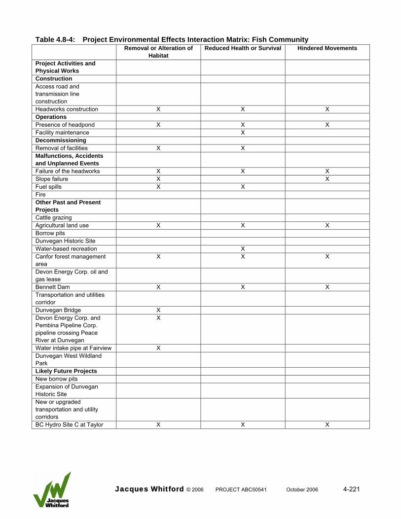
Table 4.8-4: Project Environmental Effects Interaction Matrix: Fish Community
Removal or Alteration of Habitat
Reduced Health or Survival Hindered Movements
Project Activities and Physical Works
Construction Access road and transmission line construction
Headworks construction X X X Operations Presence of headpond X X X Facility maintenance X Decommissioning Removal of facilities X X Malfunctions, Accidents and Unplanned Events
Failure of the headworks X X X Slope failure X X Fuel spills X X Fire Other Past and Present Projects
Cattle grazing Agricultural land use X X X Borrow pits Dunvegan Historic Site Water-based recreation X Canfor forest management area
X X X
Devon Energy Corp. oil and gas lease
Bennett Dam X X X Transportation and utilities corridor
Dunvegan Bridge X Devon Energy Corp. and Pembina Pipeline Corp. pipeline crossing Peace River at Dunvegan
X
Water intake pipe at Fairview X Dunvegan West Wildland Park
Likely Future Projects New borrow pits Expansion of Dunvegan Historic Site
New or upgraded transportation and utility corridors
BC Hydro Site C at Taylor X X X
Jacques Whitford © 2006 PROJECT ABC50541 October 2006 4-221
4.8.3.1 Construction Several potential interactions between project activities and the fish community could occur during construction. Effects that may result from such interactions are: • physical removal or alteration of fish habitat
• reduced health or survival of fish
• hindered movements of fish 4.8.3.1.1 Infrastructure Development Uncontrolled runoff from disturbed shoreline areas or disturbance of the stream bottom could result in increased sediment inputs. If increased sediment input occurs during periods of low suspended sediment concentrations (i.e., late fall and winter), this could reduce habitat quality and cause mortality of sensitive life stages of fish (e.g., eggs and larvae). Likewise, a toxic materials spill could affect fish directly by causing mortality or indirectly through degradation of habitat. Instream construction may hinder upstream fish movements in the mainstem Peace River and tributaries. If this prevents access to critical habitats, the viability of fish populations may be affected. The isolated construction areas may also cause stranding of fish during dewatering. In addition, pumping activities have the potential to impinge fish resulting in mortality. 4.8.3.1.2 Use of Explosives and Driving Cofferdam Sheet Piles Explosives may be used for excavation of bedrock. Possible locations for explosives use include bridge approaches across Hines and Dunvegan creeks and fishway installations on each bank of the Peace River. Explosives can affect the survival of fish by causing physical damage to fish and fish eggs. There are no plans to use explosives in the aquatic environment. Cofferdam sheet piles will be used to isolate the headworks construction cells, the fishway installations on each bank and possibly at the bridge approaches across Hines and Dunvegan creeks. Driving sheet piles has the potential to disturb or harm fish through production of pressure waves. 4.8.3.1.3 Workforce The presence of a large workforce during the construction period has the potential to reduce fish survival due to recreational angling. 4.8.3.2 Operations Effects on the fish community during the operations phase are dependent on the project component, but the effects from such interactions would include those identified under the construction phase as follows:
Jacques Whitford © 2006 PROJECT ABC50541 October 2006 4-222
• physical removal or alteration of fish habitat
• reduced health or survival of fish
• hindered movements of fish 4.8.3.2.1 Headworks Operation The headworks facility on the mainstem Peace River and bridge crossings on Dunvegan Creek and Hines Creek will result in the permanent removal of approximately 4 ha of fish habitat. Adverse effects could result if habitats that are critical to the viability of the population are no longer available (e.g., spawning habitat). The headworks may alter fish habitat downstream from the facility in a number of ways. Without the incorporation of mitigative features in the headworks design, water flow over the weir could increase total gas pressure, which would reduce the suitability of the downstream area for fish. The headworks will affect the initiation and duration of ice formation in the headpond, which, in turn, will eliminate the source of frazil ice required for ice formation downstream from the structure. The result will be an open water area that extends several kilometres downstream. A portion of this open water has the potential to be used as wintering habitat by fish. Without mitigation upstream and downstream fish movements in Peace River will be affected by the headworks facility. Effects could include complete blockage or delays of sufficient duration that prevent fish from accessing important habitats in a timely fashion. Without mitigation, fish undertaking downstream movements could be affected by spillway and turbine operation. Fish encountering the headworks will either move around the powerhouse to the spillway (when operational) or they will attempt to enter the turbines. Some fish moving over the spillway could suffer physical damage; fish attempting to pass through the turbines may be harmed or impinged on trash racks in front of the turbines. 4.8.3.2.2 Headpond Formation The headpond will inundate up to 26 km of the mainstem Peace River and 1000 m of the Ksituan River. Water depths in the headpond will increase and water velocities will be reduced, which will result in deposition of sediments. Deposition of large sediments (i.e., gravels and cobbles) will be most prominent at the upstream end of the headpond, which could provide spawning and feeding habitats. Throughout the remainder of the headpond, low velocity zones associated with the channel margins and the downstream ends of islands will be deposition zones for smaller particles (i.e., sands). Similarly, the inundated section of the Ksituan River would also in-fill with sediments. This change will result in alteration of fish habitat in both river systems. Although a fluvial environment will remain in the headpond, habitats that are characterized by shallow depths and higher velocities will decrease in extent and distribution. In contrast, habitats characterized by greater depths and lower velocities will become more prominent. The increased water depth and lower water velocities will promote formation of a more stable and thinner ice sheet compared to what
Jacques Whitford © 2006 PROJECT ABC50541 October 2006 4-223
forms under present conditions. This change could increase the availability of overwintering habitat for fish in the headpond. An increase in water level will result in a new water-bank interface zone that will inundate approximately 165 ha of the river valley (at 50 percent exceedance). The inundated area will range between 106 ha and 215 ha at 5 percent and 95 percent exceedance conditions, respectively. This could induce bank erosion until a new equilibrium is reached. Sediment introductions resulting from this erosion could alter fish habitat within and immediately downstream from the headpond. 4.8.3.2.3 Maintenance Given the longevity of the Project (expected life span of 100 years) maintenance of several structures will be required. Refurbishing of the bridges across Hines and Dunvegan creeks and refurbishing of the public boat ramp will have minimal interaction with the fish community unless blasting and extensive earthworks are required, which is unlikely. 4.8.3.2.4 Public Access The boat ramp and the boat lock will facilitate public access to the headpond. This may lead to an increase in fish harvest rates. 4.8.3.3 Decommissioning 4.8.3.3.1 Project Infrastructure The Project has an expected life span of 100 years, but may never be decommissioned because the turbines and other components can be replaced. Decommissioning of project infrastructure, if it occurs, would involve removal of the physical infrastructure of the Project. For these facilities, it is assumed that decommissioning activities and their potential effects will be similar to those identified for construction, although of shorter duration. A decommissioning plan will be prepared and reviewed by the regulatory agencies and will meet the standards and requirements at that time. 4.8.3.3.2 Headpond De-watering It is assumed that decommissioning of the headpond will lower water levels to pre-development elevations. This could result in significant changes to the fish community that developed during the 100 year life span of the Project. At the termination of operations, it is expected that a large percentage of the headpond may have in-filled with sediments. Lowering of the water levels could potentially cause the river channel to down cut through these sediments, resulting in resuspension of smaller particles and movement of a large amount of bed material load. Dewatering and down cutting could remove or alter habitats both within the previous headpond area and downstream from the project area. Down cutting of the river channel may also create a perched confluence of the Ksituan River that would hamper fish access to this tributary during periods of low discharge.
Jacques Whitford © 2006 PROJECT ABC50541 October 2006 4-224

4.8.3.4 Malfunctions and Accidents Although the probability of occurrence is low, malfunctions and accidents could have serious consequences to the fish community, which include removal or alteration of habitat, hindrance of fish movements, and negative effects on fish health and survival. There are four types of malfunctions and accidents related to the Project: • infrastructure failure (due to a design flaw, large flood event or ice damage)
• massive slope failure
• flood induced large-scale bank erosion
• accidental spill of toxic materials Structural failure may involve any physical component of the project infrastructure and could occur during any phase of the Project. Slope failure and large-scale bank erosion are specific to the headpond zone. Access roads to the Project will be used to transport a large volume of materials during the headworks construction phase. A number of potentially hazardous materials may be transported on these access roads; the primary concerns, in terms of frequency and volume, are diesel fuel and concrete. An accidental spill involving a large volume of these materials (e.g., an overturned transport truck) in close proximity to the Peace River or Hines and Dunvegan creeks could potentially introduce contaminants into the aquatic environment. 4.8.3.5 Past, Present, and Likely Future Projects The Peace River watershed supports a diverse assemblage of human activities (Wrona et al. 1996), many of which influence the aquatic environment in the project area. Agriculture and wood extraction activities are widespread land-based operations that can induce changes to the watershed by altering the hydraulic regime and introducing contaminants. The aquatic environment in the project area is affected by flow regulation of Peace River at Bennett Dam. This has resulted in widespread changes to Peace River in the project area that include seasonal redistribution of flow, a reduction in magnitude, frequency and duration of peak flow events, cyclic inundation and dewatering of the active channel, and a general reduction of channel dimensions. Other important changes induced by flow regulation are modification of the temperature and ice regimes. All influence the fish community in the RSA and the Project may contribute to the effects. 4.8.4 Residual Environmental Effects Evaluation Criteria The purpose of this section is to define the criteria used to evaluate the significance of the Project on the fish community. For the purposes of this environmental effects assessment, a significant adverse effect is defined as:
Jacques Whitford © 2006 PROJECT ABC50541 October 2006 4-225
A significant adverse effect on fish community is any project-related activity that affects a fish community in sufficient magnitude, duration, or frequency, as to cause a change that would not allow that community to return to its former structure. This change is manifested directly through differences in abundance, growth, reproduction, health, and survival of one or more species populations that comprise that community. Alternatively, the change can be induced indirectly through removal or alteration of habitat, reduced food production, and hindered movements. It is assumed that any change to a specific population will cause a change in the fish community. For the purposes of assessment, project effects on the fish community will be manifested in three ways: • habitat loss or alteration
• reduced health and survival
• hindered fish movement Each has the potential to affect the viability of the fish community, through a reduction in overall fish abundance or a change in species composition. 4.8.4.1 Rating Categories Significance rating categories are as follows: • magnitude
• geographic extent
• duration
• frequency
• reversibility
• ecological context
• level of confidence
• probability of occurrence
• scientific certainty 4.8.4.1.1 Magnitude Magnitude describes the nature and extent of the environmental effect. The magnitude of an effect is quantified in terms of the amount of change in a parameter or variable from an appropriate threshold value, which may be represented by a guideline or baseline conditions. Three general categories of change to be employed are low, medium, and high. The definitions used to rate the magnitude will depend on the type of effect, the methods available to measure the effect, and the accepted practices for a particular discipline.
Jacques Whitford © 2006 PROJECT ABC50541 October 2006 4-226

Habitat loss or alteration can refer to the physical removal of an area that is important to the well-being of a species population (e.g., spawning site). Habitat loss can also be manifested by altering the characteristics of an area in such a way as to reduce or eliminate its value to fish. For the purpose of this assessment, important habitats are defined as spawning, rearing, feeding, and overwintering. The criteria used to quantify the magnitude of effect on a species population as a result of habitat loss are: • low (1) 10 percent loss of important habitat • moderate (2) greater than 10 to 20 percent loss of important habitat • high (3) greater than 20 percent loss of important habitat These criteria assume a direct correlation between the amount of habitat and fish abundance. Although this relationship cannot be substantiated quantitatively, percent loss of important habitat provides a conservative estimate of effect. Reduced health and survival incorporates several parameters that influence fish abundance. These include direct mortality, as well as reduced growth and reproduction caused by physiological stress or the lack of food. The criteria used to quantify the magnitude of effect on fish populations as a result of reduced health and survival are: • low (1) 10 percent change in fish population abundance • moderate (2) greater than 10 to 20 percent change in fish population abundance • high (3) greater than 20 percent change in fish population abundance Hindered fish movement refers to an unacceptable delay in the timing of movements or reduction in number of fish that must move past a potential obstacle. Unacceptable delay is defined as a period that exceeds 15 days. The consequences of hindered fish movement include loss of timely access to important habitats or loss of genetic diversity. The criteria used to quantify the magnitude of effect of hindered fish movement is based on relative effects on immature and mature (spawning) components of the fish population rather on the number of fish affected. This approach was adopted due to the absence quantitative estimates of fish numbers that move through the LSA. Criteria are as follows: • low (1) movement of the immature component of the population is hindered • moderate (2) movement of a the immature component and a portion of the mature
component of the population are hindered • high (3) movement of all fish in the population are hindered 4.8.4.1.2 Geographic Extent Geographic extent is similar to the spatial boundaries of the assessment outlined in Section 4.8.1.1. It can be separated into three ratings as follows:
Jacques Whitford © 2006 PROJECT ABC50541 October 2006 4-227
• sublocal (1) includes specific areas within the immediate influence of the project components or activities (e.g., the headworks construction zone)
• local (2) includes the area within the influence of the Project (the headworks, headpond, and immediately adjoining areas)
• regional (3) includes the Peace River and major tributaries from the Peace Canyon Dam to Vermillion Chutes, excluding the local study area
4.8.4.1.3 Duration and Timing Duration is defined as a measure of the length of time that the potential effect could last. It is closely related to the project phase or activity that could cause the effect. The three project phases that define the temporal boundaries (Section 4.8.1.2) include construction, operations and decommissioning. The duration ratings are divided into three classes based on the time scale of each project phase: • short-term (1) effects lasting for less than one year (e.g. associated with the construction and
decommissioning periods, or other short-term activities) • mid-term (2) effects lasting from one to 30 years (e.g. associated with the decommissioning
phase) • long-term (3) effects lasting longer than 30 years (e.g. operations phase) 4.8.4.1.4 Frequency Frequency is associated with duration and defines the number of occurrences that can be expected during each phase of the Project. The frequency ratings are divided into three classes: • low (1) effects occur infrequently during each phase (one event) • moderate (2) effects occur frequently during each phase • high (3) effects occur continuously 4.8.4.1.5 Reversibility Reversibility is the ability of the fish community to return to conditions that existed prior to the adverse environmental effect. Two ratings will be used: reversible (R) and not reversible (NR). 4.8.4.1.6 Ecological Context Ecological context is a measure of the relative importance of the affected ecological component to the ecosystem, or the sensitivity of the ecosystem to disturbance. The ecological context ratings are grouped into two classes: a relatively pristine area or an area not adversely affected by human activity (1) and evidence of previous adverse effects (2).
Jacques Whitford © 2006 PROJECT ABC50541 October 2006 4-228
4.8.4.1.7 Level of Confidence Using the rating criteria described in the preceding paragraphs, the significance of adverse environmental effects is evaluated based on a review of project-specific data, relevant literature and professional opinion. Three rating classes are used to assess the level of confidence: low (1), moderate (2), and high (3). 4.8.4.1.8 Probability of Occurrence The more likely that an adverse effect will or will not occur, the higher the level of confidence that an adverse effect will be or will not be significant. Probability of occurrence is rated using three classes as follows: low (1), moderate (2), and high (3). 4.8.4.1.9 Scientific Certainty During the assessment of significance, it is desirable to apply rigorous scientific or statistical methods (quantitative approach), but where such methods are not feasible, professional judgment is usually employed (qualitative approach). Rating the scientific certainty of significance is an additional step that can be used to justify or substantiate the likelihood that a significant adverse effect will occur. The three ratings that will be applied are: low (1), moderate (2), and high (3). 4.8.5 Effects Analysis, Mitigation and Residual Environmental Effects Prediction The environmental effects analysis will assess whether a potential environmental effect caused by a specific project activity is adverse. Based on a detailed assessment of activities related to the component and phase of the development, the Project will have twelve interaction pathways that may affect the fish community (Table 4.8-5). Some interactions are common to most project components and phases (e.g., sediment inputs), while others are specific to a particular phase and component (e.g., use of explosives). The effects analysis section has been structured so as to discuss the effects on the fish community through each successive project phase, rather than through a discussion of individual project issues such as sediments, contaminants and fish habitat.
Jacques Whitford © 2006 PROJECT ABC50541 October 2006 4-229
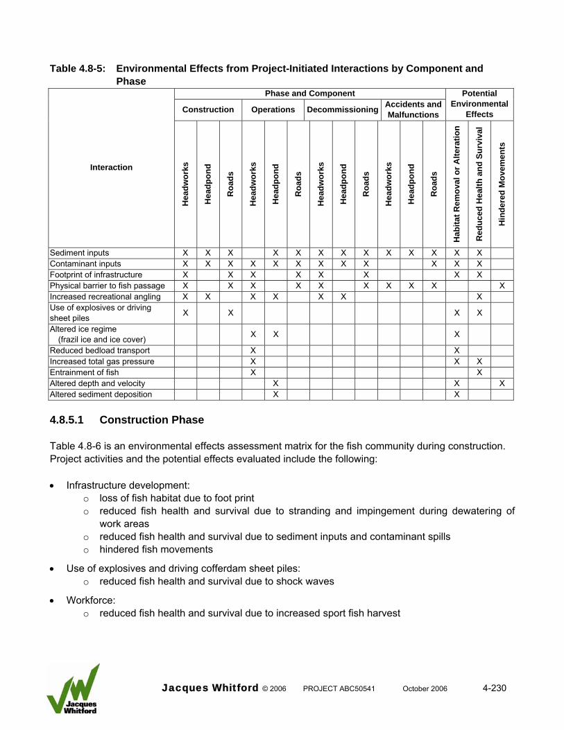
Table 4.8-5: Environmental Effects from Project-Initiated Interactions by Component and
Phase Phase and Component
Construction Operations Decommissioning Accidents and Malfunctions
Potential Environmental
Effects
Interaction
Hea
dwor
ks
Hea
dpon
d
Roa
ds
Hea
dwor
ks
Hea
dpon
d
Roa
ds
Hea
dwor
ks
Hea
dpon
d
Roa
ds
Hea
dwor
ks
Hea
dpon
d
Roa
ds
Hab
itat R
emov
al o
r Alte
ratio
n
Red
uced
Hea
lth a
nd S
urvi
val
Hin
dere
d M
ovem
ents
Sediment inputs X X X X X X X X X X X X X Contaminant inputs X X X X X X X X X X X X Footprint of infrastructure X X X X X X X X Physical barrier to fish passage X X X X X X X X X X Increased recreational angling X X X X X X X Use of explosives or driving sheet piles X X X X
Altered ice regime (frazil ice and ice cover) X X X
Reduced bedload transport X X Increased total gas pressure X X X Entrainment of fish X X Altered depth and velocity X X X Altered sediment deposition X X 4.8.5.1 Construction Phase Table 4.8-6 is an environmental effects assessment matrix for the fish community during construction. Project activities and the potential effects evaluated include the following: • Infrastructure development:
o loss of fish habitat due to foot print o reduced fish health and survival due to stranding and impingement during dewatering of
work areas o reduced fish health and survival due to sediment inputs and contaminant spills o hindered fish movements
• Use of explosives and driving cofferdam sheet piles: o reduced fish health and survival due to shock waves
• Workforce: o reduced fish health and survival due to increased sport fish harvest
Jacques Whitford © 2006 PROJECT ABC50541 October 2006 4-230
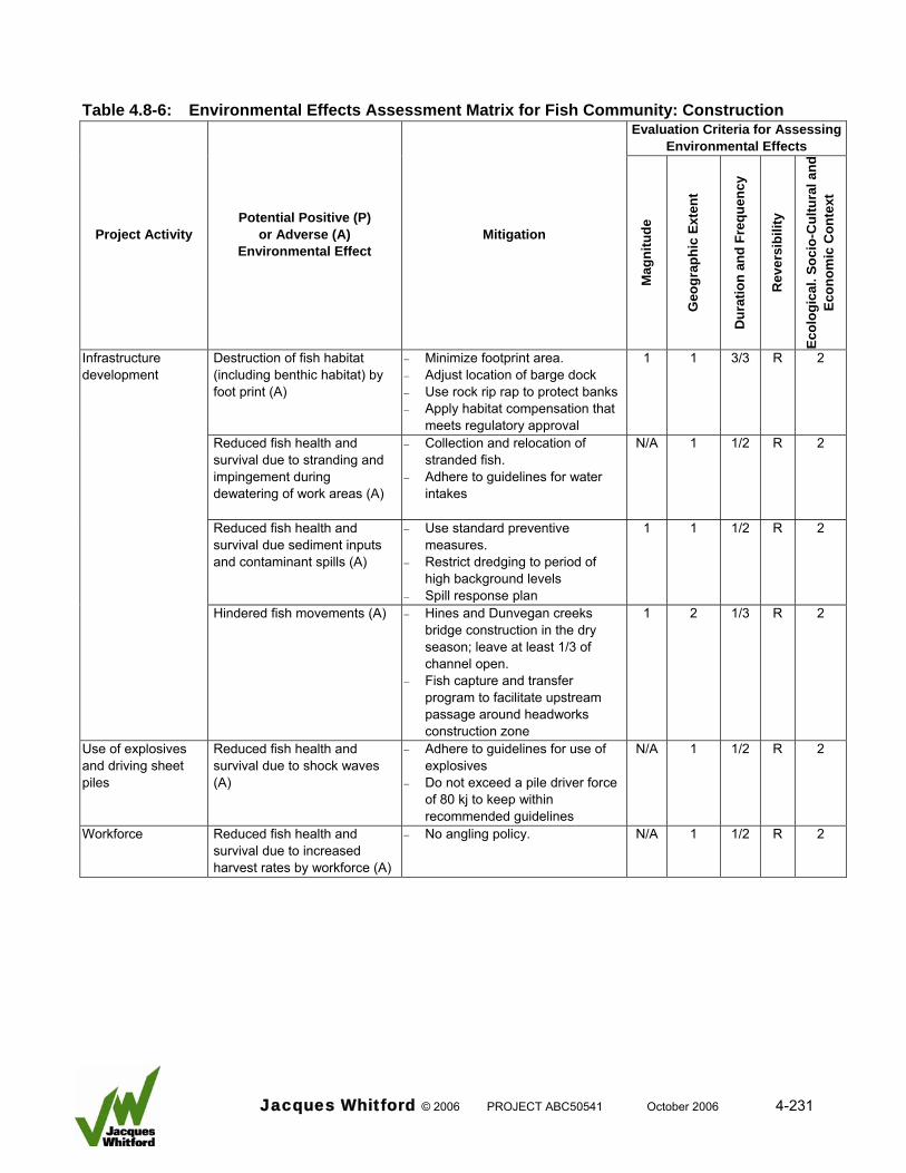
Table 4.8-6: Environmental Effects Assessment Matrix for Fish Community: Construction
Evaluation Criteria for Assessing Environmental Effects
Ecol
ogic
al. S
ocio
-Cul
tura
l and
Ec
onom
ic C
onte
xt
Project Activity Potential Positive (P)
or Adverse (A) Environmental Effect
Mitigation
Mag
nitu
de
Geo
grap
hic
Exte
nt
Dur
atio
n an
d Fr
eque
ncy
Rev
ersi
bilit
y
Destruction of fish habitat (including benthic habitat) by foot print (A)
− Minimize footprint area. − Adjust location of barge dock − Use rock rip rap to protect banks − Apply habitat compensation that
meets regulatory approval
1 1 3/3 R 2
Reduced fish health and survival due to stranding and impingement during dewatering of work areas (A)
− Collection and relocation of stranded fish.
− Adhere to guidelines for water intakes
N/A 1 1/2 R 2
Reduced fish health and survival due sediment inputs and contaminant spills (A)
− Use standard preventive measures.
− Restrict dredging to period of high background levels
− Spill response plan
1 1 1/2 R 2
Infrastructure development
Hindered fish movements (A) − Hines and Dunvegan creeks bridge construction in the dry season; leave at least 1/3 of channel open.
− Fish capture and transfer program to facilitate upstream passage around headworks construction zone
1 2 1/3 R 2
Use of explosives and driving sheet piles
Reduced fish health and survival due to shock waves (A)
− Adhere to guidelines for use of explosives
− Do not exceed a pile driver force of 80 kj to keep within recommended guidelines
N/A 1 1/2 R 2
Workforce Reduced fish health and survival due to increased harvest rates by workforce (A)
− No angling policy. N/A 1 1/2 R 2
Jacques Whitford © 2006 PROJECT ABC50541 October 2006 4-231
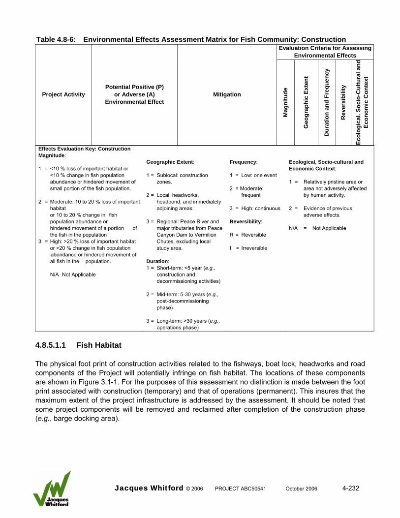
Table 4.8-6: Environmental Effects Assessment Matrix for Fish Community: Construction
Evaluation Criteria for Assessing Environmental Effects
Ecol
ogic
al. S
ocio
-Cul
tura
l and
Ec
onom
ic C
onte
xt
Project Activity Potential Positive (P)
or Adverse (A) Environmental Effect
Mitigation
Mag
nitu
de
Geo
grap
hic
Exte
nt
Dur
atio
n an
d Fr
eque
ncy
Rev
ersi
bilit
y
Effects Evaluation Key: Construction Magnitude: 1 = <10 % loss of important habitat or
<10 % change in fish population abundance or hindered movement of small portion of the fish population.
2 = Moderate: 10 to 20 % loss of important
habitat or 10 to 20 % change in fish
population abundance or hindered movement of a portion of
the fish in the population 3 = High: >20 % loss of important habitat
or >20 % change in fish population abundance or hindered movement of all fish in the population.
N/A Not Applicable
Geographic Extent: 1 = Sublocal: construction
zones. 2 = Local: headworks,
headpond, and immediately adjoining areas.
3 = Regional: Peace River and
major tributaries from Peace Canyon Dam to Vermilion Chutes, excluding local study area.
Duration: 1 = Short-term: <5 year (e.g.,
construction and decommissioning activities)
2 = Mid-term: 5-30 years (e.g.,
post-decommissioning phase)
3 = Long-term: >30 years (e.g.,
operations phase)
Frequency: 1 = Low: one event 2 = Moderate:
frequent 3 = High: continuous Reversibility: R = Reversible I = Irreversible
Ecological, Socio-cultural and Economic Context: 1 = Relatively pristine area or
area not adversely affected by human activity.
2 = Evidence of previous
adverse effects. N/A = Not Applicable
4.8.5.1.1 Fish Habitat The physical foot print of construction activities related to the fishways, boat lock, headworks and road components of the Project will potentially infringe on fish habitat. The locations of these components are shown in Figure 3.1-1. For the purposes of this assessment no distinction is made between the foot print associated with construction (temporary) and that of operations (permanent). This insures that the maximum extent of the project infrastructure is addressed by the assessment. It should be noted that some project components will be removed and reclaimed after completion of the construction phase (e.g., barge docking area).
Jacques Whitford © 2006 PROJECT ABC50541 October 2006 4-232
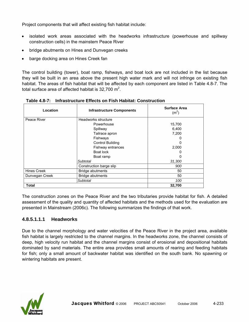
Project components that will affect existing fish habitat include: • isolated work areas associated with the headworks infrastructure (powerhouse and spillway
construction cells) in the mainstem Peace River
• bridge abutments on Hines and Dunvegan creeks
• barge docking area on Hines Creek fan
The control building (tower), boat ramp, fishways, and boat lock are not included in the list because they will be built in an area above the present high water mark and will not infringe on existing fish habitat. The areas of fish habitat that will be affected by each component are listed in Table 4.8-7. The total surface area of affected habitat is 32,700 m2.
Table 4.8-7: Infrastructure Effects on Fish Habitat: Construction
Location Infrastructure Components Surface Area (m2)
Peace River Headworks structure Powerhouse 15,700 Spillway 6,400 Tailrace apron 7,200 Fishways 0 Control Building 0 Fishway entrances 2,000 Boat lock 0 Boat ramp 0 Subtotal 31,300 Construction barge slip 900
Hines Creek Bridge abutments 50 Dunvegan Creek Bridge abutments 50 Subtotal 100 Total 32,700
The construction zones on the Peace River and the two tributaries provide habitat for fish. A detailed assessment of the quality and quantity of affected habitats and the methods used for the evaluation are presented in Mainstream (2006c). The following summarizes the findings of that work. 4.8.5.1.1.1 Headworks Due to the channel morphology and water velocities of the Peace River in the project area, available fish habitat is largely restricted to the channel margins. In the headworks zone, the channel consists of deep, high velocity run habitat and the channel margins consist of erosional and depositional habitats dominated by sand materials. The entire area provides small amounts of rearing and feeding habitats for fish; only a small amount of backwater habitat was identified on the south bank. No spawning or wintering habitats are present.
Jacques Whitford © 2006 PROJECT ABC50541 October 2006 4-233
4.8.5.1.1.2 Bridge Abutments Fish habitat that may be affected by the bridge construction zones in Hines and Dunvegan creeks is used on a seasonal basis and is of limited value to fish. The affected areas in both creeks are characterized by riffle and run dominated by sand substrates, interspersed with cobbles and gravels. These areas are probably used for spawning by sucker species and cyprinids. Because these systems exhibit intermittent flow and high summer temperatures, the habitats are only available in spring and during periods with high rainfall. 4.8.5.1.1.3 Barge Docking Area The barge docking area is situated on the upstream portion of the Hines Creek fan, which extends into the Peace River. The barge docking area is in an existing shallow back channel at the most upstream portion of the fan. The area receives the brunt of the ice floes during breakup and is gouged, compacted and reshaped every year. It will consist of deepened (approximately 1.2 m depth) and a 100-m long by 2-m high sheet pile wall to form a gravel ramp level with the barge deck height. The choice of a barge docking site was based on consideration of the following characteristics: • proximity to the headworks
• environmental sensitivity
• slower river currents
• stable, dry site for storage of materials
• within boomed area for safety reasons Alternative sites considered for the barge docking site included building out the riverbank near the access roads on either bank. The problem with these sites is the steepness of the banks, the lack of nearby large laydown areas and the river current. In addition, there would be difficulty manoeuvring through the safety boom at these sites, particularly along the south bank. The barge docking site has been sited to avoid infringing on important fish habitat provided by Hines Creek tributary fan. The foot print of the barge docking site will not exceed 4500 m2 of the wetted Peace River channel. The area consists of bank habitat dominated by silts, sands, and cobbles and instream habitat dominate by slow run. It is not considered important fish habitat. Mitigation • the barge area has been sited to avoid effects on the Hines Creek tributary shoal
• clean rock fill and rip-rap will be used where appropriate to protect the banks of Hines and Dunvegan creeks - these materials provide better quality habitat than native material
• permanent effects of habitat loss caused by the Project are fully addressed by habitat compensation measures outlined in Mainstream (2006c)
Jacques Whitford © 2006 PROJECT ABC50541 October 2006 4-234
Effects Evaluation As the areas removed from production by the foot print of the project infrastructure provide habitat for fish, there is the potential for an adverse effect. The area of affected habitat is small relative to the area of habitat available in the remainder of the local project area (3.3 ha or 0.6 percent of total available local habitat) and there are no important habitats. Fish populations will adjust by using habitats available in adjacent locations. In addition, measures have been developed to address the issue of habitat destruction and alteration associated with these and other project components (i.e., headpond inundation). Based on this information, effects on fish habitat caused by the project infrastructure would be negligible. 4.8.5.1.2 Fish Health and Survival Fish health and survival would potentially be affected by construction activities as follows: • stranding of fish in isolated work areas during dewatering
• impingement of fish on pump intakes during dewatering
• excessive recreational harvest by workforce personnel
• sediments inputs during instream construction and by surface runoff from offstream work areas
• introduction of toxic substances during instream construction activities (e.g., fuel and concrete)
• shock waves from use of explosives and driving metal sheet piles 4.8.5.1.2.1 Stranding Stranding of fish within the isolated construction zones would affect fish survival because the enclosed areas will be dewatered to allow construction activities. For the headworks zone, dewatering will occur periodically during the construction period as construction cells are added to the infrastructure. Isolated work areas for the north and south bank fishways will be dewatered. There is also the possibility that the work areas for the bridge abutments on Hines and Dunvegan creeks would be dewatered. Stranding of fish will be fully mitigated. Fish will be collected from each construction cell as it is dewatered and relocated. Fish salvage is a standard mitigation technique for isolated work areas that are dewatered that is recommended by the provincial (Alberta Water Act Code of Practice) and federal governments (Fisheries Act Operational Statements). 4.8.5.1.2.2 Impingement during Dewatering Dewatering of isolated work areas will be required during construction. Dewatering systems will entail use of one or more pumps to draw down and maintain the work areas in dry condition. Impingement on intake screens or entrainment of fish into the pump intakes would cause direct mortality of fish. The DFO has specific guidelines for the screening of water intake structures for the protection of fish (DFO 1995). The guidelines present design criteria that are intended to protect small fish, such as young of the year and juveniles, which are most susceptible to entrainment. The criteria are based on fish length, swimming ability, and water uptake volume per unit time, and are used to specify
Jacques Whitford © 2006 PROJECT ABC50541 October 2006 4-235
requirements for screen mesh size, water velocity, and surface area of the intake opening. Adhering to these criteria ensures that fish of a minimum size are not drawn into water intake structures. These screening guidelines will be adhered to during dewatering. This mitigation measure will eliminate the potential effects of impingement causing fish mortality. 4.8.5.1.2.3 Excessive Harvest The workforce associated with project construction has the potential to affect fisheries resources in the vicinity of the project area and in adjacent waterbodies through increased recreational angling. To eliminate the potential effect of over harvest, Glacier Power is willing, after discussions with ASRD, to implement a no angling policy near the Project. The preferred option is a complete ban on angling by workforce personnel as a condition of employment. Implementation of this mitigation measure will eliminate the potential effect of increased harvest by workforce personnel. 4.8.5.1.2.4 Introduction of Sediments Several construction activities have the potential to introduce sediments into the aquatic environment. Major sources include the following: • surface runoff from offstream laydown areas
• surface runoff from access road construction zones
• transport of excavated bed material to offstream storage areas
• dredging the channel bottom for placement of precast concrete barges
• pre-drilling the channel bottom prior to driving cofferdam sheet piles
• driving cofferdam sheet piles The amount of sediments produced by these activities cannot be accurately quantified, but they are expected to be large. For example 53,000 m3 of bed material will need to be dredged during instream construction of the headworks (see Project Description Section 3.0). The quantities of sediment released by project construction will depend on the nature and extent of activities carried out in and adjacent to the river, the specific characteristics of materials involved and the mitigation measures employed. Elevated suspended sediment concentrations are known to be harmful to fish (Newcombe 1994, Anderson et al. 1995). These effects include decreased health and reduced viability of eggs and larvae, irritation of gills, and smothering of food production areas making habitats unsuitable for fish. The suspended sediment concentrations that occur in the Peace River during the open water period can reach very high levels (e.g., greater than 1000 mg/L). Concentrations are correlated with discharge and show a strong seasonal pattern (Table 4.8-8). High concentrations occur in spring and summer, whereas lower concentrations occur in fall and winter.
Jacques Whitford © 2006 PROJECT ABC50541 October 2006 4-236
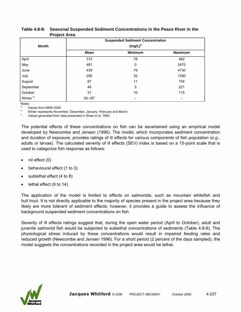
Table 4.8-8: Seasonal Suspended Sediment Concentrations in the Peace River in the
Project Area Suspended Sediment Concentration
(mg/L)aMonth
Mean Minimum Maximum
April 315 78 482 May 481 0 2470 June 439 79 4730 July 256 32 1390 August 87 11 734 September 46 5 221 October 31 10 115 Winter b 20–30c - - Notes: a Values from MMA 2000. b Winter represents November, December, January, February and March. c Values generated from data presented in Shaw et al. 1990.
The potential effects of these concentrations on fish can be ascertained using an empirical model developed by Newcombe and Jensen (1996). The model, which incorporates sediment concentration and duration of exposure, provides ratings of ill effects for various components of fish population (e.g., adults or larvae). The calculated severity of ill effects (SEV) index is based on a 15-point scale that is used to categorize fish response as follows: • nil effect (0)
• behavioural effect (1 to 3)
• sublethal effect (4 to 8)
• lethal effect (9 to 14) The application of the model is limited to effects on salmonids, such as mountain whitefish and bull trout. It is not directly applicable to the majority of species present in the project area because they likely are more tolerant of sediment effects; however, it provides a guide to assess the influence of background suspended sediment concentrations on fish. Severity of ill effects ratings suggest that, during the open water period (April to October), adult and juvenile salmonid fish would be subjected to sublethal concentrations of sediments (Table 4.8-9). The physiological stress induced by these concentrations would result in impaired feeding rates and reduced growth (Newcombe and Jensen 1996). For a short period (2 percent of the days sampled), the model suggests the concentrations recorded in the project area would be lethal.
Jacques Whitford © 2006 PROJECT ABC50541 October 2006 4-237
Table 4.8-9: Severity of Ill Effects Based on Suspended Sediments in the Peace River at the
Project Area Consecutive Days that
Exceeded Concentration Adults and Juvenile Fish Eggs and Larvae
Number Percent
Concentration (mg/L)a
SEV Rating Category SEV Rating Category
184 100 7 7.6 Sublethal 13.5 Lethal
109 59 20 8.1 Sublethal 13.3 Lethal
56 30 55 8.4 Sublethal 12.9 Lethal
40 22 148 8.9 Sublethal 12.8 Lethal
9 5 403 8.8 Sublethal 11.5 Lethal
4 2 1097 9.0 Lethal 10.9 Lethal
Notes: b Values generated from data presented in MMA 2000. SEV Severity of ill effects
The model ratings for salmonid fish eggs and larvae indicate severe conditions. Effects causing delayed hatching, reduced feeding, and extensive mortality would occur at all times during the open water period. This indicates that salmonids in the project area would be unable to successfully incubate eggs and rear larval fish. This applies to the winter incubation periods of mountain whitefish and bull trout when suspended sediment concentrations typically do not fall below 20 mg/L (Table 4.8-8). Based on the model predictions, existing background suspended sediment concentrations in the Peace River would have sublethal and lethal effects on salmonid fish. Clearly, the presence of viable fish populations in the project area indicates that most fish species have adapted to these high background levels. Mitigation Standard mitigation measures will be employed during construction to eliminate sediment input into the aquatic environment from offstream activities (see Section 3). The proposed measures will include standard techniques recommended by transportation agencies (Alberta Infrastructure 1999) and the pipeline industry (Canadian Pipeline Water Crossing Committee 2005). Several specific mitigation measures will be implemented to eliminate sediment inputs from surface runoff and minimize sediment inputs during instream construction activities as follows: • use of containment ponds that include appropriate settling, skimming and decanting features
• testing of water for acceptable water quality before release back to the aquatic environment
• terminate activities during intense rainfall or when the ground becomes saturated
• carry out dredging during periods when high levels of sediment transport occur (April to July)
• use of a suction dredging equipment to minimize sediment release
Jacques Whitford © 2006 PROJECT ABC50541 October 2006 4-238
• maintain a positive head inside the construction cells to prevent sediments in the cells from entering the aquatic environment
• controlled removal of material excavated from the cells using a conveyor system to prevent sediment from entering the aquatic environment
Effects Evaluation Sediment inputs associated with surface runoff from offstream construction areas can be contained and treated using standard mitigation practices prior to release back to the aquatic environment. Instream construction activities will generate substantial amounts of sediment. Mitigation measures will be applied to reduce, but not eliminate those sediment inputs. The fish community in the project area is pre-adapted to cope with the existing high suspended sediment levels in the Peace River. Restricting dredging to periods of high background sediment levels will substantially reduce the potential effects of this activity. Other activities that could input sediments will be managed to minimize inputs. Based on this information, the effects of sediment inputs are deemed to be negligible. 4.8.5.1.2.5 Introduction of Contaminants Construction activities related to the headworks, headpond, and road components may introduce contaminants into the aquatic environment via a release of toxic materials. Operation of heavy equipment (e.g., trucks, loaders, and excavators) in and adjacent to the aquatic environment has the potential for the spillage of hydraulic oils and diesel, which are harmful to fish. Concrete, which will be used for construction of the headworks and bridges, also is toxic to fish (Envirochem 1997). Mitigation Standard mitigation measures will be employed during construction to minimize the potential for introduction of contaminants as follows (see Section 3.0): • fuel storage tanks will be a minimum of 100 m from a waterbody and be placed on an impermeable
base, which will be bermed and designed to hold 110 percent of the tank capacity
• equipment will be fuelled and maintained off site to prevent drainage spill materials into the aquatic environment
• spill contingency plans will be complied to address accidental fuel and oils spills. Containment equipment will be on site along with personnel properly trained for their use
• concrete activities would be developed such that cement will not be released into the water
• application of tremie concrete within construction cells prior to dewatering would occur only under conditions of negative hydrostatic pressure to prevent leakage of concrete into the aquatic environment
• runoff from areas under concrete construction will be directed to offstream settling basins, monitored, treated, and only released after testing demonstrates compliance
Jacques Whitford © 2006 PROJECT ABC50541 October 2006 4-239
Effects Evaluation Mitigation measures will eliminate the potential for contaminant inputs from minor spills during construction activities; therefore, there will be negligible effects on the fish community. 4.8.5.1.2.6 Use of Explosives and Driving Sheet Piles Explosives may be used for excavation of bedrock at bridge approaches across Hines Creek and Dunvegan Creek and fishway installations on each bank of the Peace River. Cofferdam sheet piles will be used to isolate the headworks construction cells, the fishway installations on each bank and possibly at the bridge approaches across Hines and Dunvegan creeks. Fish can be harmed by the shock wave produced by an explosion (Wright and Hopky 1998). Shock waves cause “a rapid rise to a high peak pressure followed by a rapid decay to below ambient hydrostatic pressure” (Wright and Hopky 1998). The drop below ambient hydrostatic pressure causes most of the negative effects on fish, which can range from damage to the swim bladder or other organs to the disruption of development and mortality of fish eggs. Small fish are more susceptible to the effects of shock waves than large fish (Wright 1982) and disturbance to fish behaviour has also been recorded (Wright and Hopky 1998). Two components of the shock wave harm fish and fish eggs: an instantaneous pressure change or “over pressure” and “peak particle velocity”, which is a measure of ground vibration. Based on Department of Fisheries and Oceans (DFO) guidelines for the protection of fish, the threshold of damage for instantaneous pressure change is 100 kPa measured in the swim bladder of a free swimming fish. Peak particle velocity below 13 mm/s is recommended to ensure the protection of eggs (Wright and Hopky 1998). Both thresholds are based on a 50 percent mortality rate (Wright,, pers. comm.). The intensity of the shock wave produced will vary depending on the weight of the charge, the distance from the point of the explosion, the time delay between explosions and the characteristics of the substances through which the shock wave is traveling. Lowering the magnitude of the shock wave caused by the explosion can be reduced below the threshold of damage to fish by adjusting the attributes of the first three parameters. Driving sheet piles may disturb or physically harm fish in the same way as an explosion: through production of a shock wave. Available information suggests that direct fish mortality can result from pile driving metal or wood posts used for mooring facilities (Vagle 2003). The magnitude of the shock wave produced by such activity depends on the force that is applied. Pile drivers having a force of 80 kJ or less do not produce shock waves that exceed DFO guidelines for the protection of fish (Vagle 2003). The pile driver proposed for use during construction of the headworks will have a force of 72 kJ (Slopek, pers. comm.) Mitigation There are a number of mitigation measures available to reduce the magnitude of the shock waves produced by the explosion (Munday et al. 1986). The most appropriate mitigation is to reduce the total weight of explosives, or separate the total explosion into a series of smaller explosions (and weights) by increasing the detonation delay period between charges (Munday et al. 1986). Guidelines for the Use of
Jacques Whitford © 2006 PROJECT ABC50541 October 2006 4-240
Explosives In or Near Canadian Fisheries Waters (Wright and Hopky 1998) recommend a minimum detonation delay period of 25 milliseconds (ms). Adherence to a minimum setback distance also would mitigate this effect. These mitigation measures will be used during construction. In addition to reducing the magnitude of the explosion, construction of the bridge abutments would occur during periods when water flows in Hines and Dunvegan creeks are lowest and fish use is minimal (late summer). The cofferdam sheet pile driver that will be used during construction of the headworks is below the size that may directly harm fish, which would mitigate the potential effects associated with this activity. No measures are planned to mitigate the effect of disturbance to fish because the period of the disturbance will be short (less than 2 months each year). Effects Evaluation Fish are expected to occur in the vicinity of the construction area during potential use of explosives along the banks and the headworks zone during cofferdam sheet pile driving. Spawning habitat does not occur in these areas; therefore, there is no potential to harm fish eggs. With the possible exception of a limited number of cyprinids, fish are not expected to occur in Hines and Dunvegan creeks during the potential blasting period of late summer and no fish eggs will be present. Based on the mitigation being proposed direct harm to fish and fish eggs will not result from use of explosives and driving cofferdam sheet piles. Fish may be disturbed by the activities, which may force them to leave the immediate vicinity of the disturbance. As such, there would be a negligible influence on fish health and survival. 4.8.5.1.3 Fish Movement Construction will occur during a four year period. Instream construction activities that may influence fish movement will occur over three years (Year Two to Year Four). In Year One activities will include off stream site preparation, construction of fishways, the headworks abutments, and boat lock along the banks of the Peace River, and development of road access to the headworks site. Road access will involve construction of bridges across Hines and Dunvegan creeks, which may require use of cofferdams for the bridge abutments. Because the enclosed construction zone will not infringe on the channel (i.e., limited to the shoreline bridge abutment) and construction will occur when the channel exhibits base flows or is dry, fish passage issues will be negligible for this project activity. The project description discusses and presents a schedule for construction activities during the four year construction period. A two-dimensional (2D) numerical model was used to investigate the hydraulic performance of the Project on the Peace River during the construction period (NHC 2004 and NHC 2006b). The report includes a summary of water velocities in the Peace River adjacent to the Project. The following provides a summary of that information as it relates to upstream fish passage. In Year One, the channel width of the Peace River will not be affected by the presence of the fishways, boat lock, and headworks abutment structures as the structures will be constructed outside of the natural channel.
Jacques Whitford © 2006 PROJECT ABC50541 October 2006 4-241
Instream construction activities will commence in April of Year Two. It will involve the staged construction of five project components. The components are four sets of powerhouse units and the spillway. Each stage of construction involves isolating the work area using sheet pile cofferdams, building the structure, and allowing water flow through upon completion. Water flow through would occur via the fish sluiceways, the spillway, and the turbine ports, if required. Water flow through reduces the head differential between upstream and downstream, which minimizes physical forces placed on the headworks infrastructure during the construction period. As each project component is completed the channel narrows and water velocities increase around the structure, which may prevent or hinder upstream fish movement. In Year Two, powerhouse units 1-10 on the south bank and powerhouse units 31-40 on the north bank will be constructed. The combined width of these components is 144 m. The total width of the headworks components that would be within the active channel would be 174 m, which represents 41 percent of the active channel width. The installation of the cofferdams for the powerhouse units would be completed in mid-June. Once the isolated work areas are in place, water velocities around the structures could exceed 1.6 m/s; however, until the cofferdams are complete the velocities around the structure will be depend on the amount of cofferdam that is in place. Upon completion of the work in September, water flow through the powerhouse units would be initiated, but velocities would remain above 1.0 m/s. Figures showing the velocities through the project area are showing in the NHC reports including the 1.0 m/s velocity contour line. This contour line was selected as it defines the approach corridors available for upstream fish movement. Commencing in April of Year Three, powerhouse units 11-20 (south bank) and the spillway would be constructed. This would result in a further restriction of the channel, particularly while there is no water flow through the powerhouse units. The reduction in channel width would increase by 212 m. Water velocities around the work areas at this time would exceed 2.8 m/s. In September of Year Three, the fish sluices, turbine ports, and spillway would be able to pass flow through the structure, but water velocities would remain above 1.0 m/s. In Year Four, the last component would be constructed (powerhouse units 21-30) extending the structure across the entire river channel forming a complete barrier to upstream fish passage. At this stage the river will be effectively blocked except for passage of flow through the various components of the Project and through the spillway. This will result in an increase in water levels upstream from the Project in order to pass flows in the river. The increased upstream water levels may allow for commissioning of the fishways. The last stage of construction consists of the completion of the ogee sections of the spillway which would be carried out in a staged approach. In August of Year Four, construction would be completed and commissioning of the headworks would commence. Based on this construction sequence and the predicted water velocities around the structure, upstream fish movements will be blocked from June Year Two until June of Year Four. This period encompasses approximately two years. (Slopek, pers. comm.) Movement patterns of fish populations in the Peace River are described in detail in Mainstream (2004a) and (2006b) and are summarized in Section 4.8.2.4. Several fish species populations undertake upstream movements during spring and early summer (April to July) as part of their annual life history strategy. The one exception is burbot, which undertakes upstream movements during late winter
Jacques Whitford © 2006 PROJECT ABC50541 October 2006 4-242
(February to March). Goldeye in the project area belong to a migratory population, while other species populations are non-migratory. However, all or portions of those populations may require upstream passage. As such three consecutive spring and early summer upstream movement periods may be blocked based on the proposed construction schedule. Downstream movements of fish will not be hampered because portions of the Peace River channel will remain open and free flow of water through the structure will facilitate downstream fish passage. Potential upstream passage routes available to fish during construction include the fish sluiceways, the turbine ports, and the perimeter of the sheet pile cofferdam. Water velocities associated with these passage routes were deemed excessive (greater than 1.0 m/s) given the distance that would need to be traveled by fish (Table 4.8-10). It is assumed that a velocity of less than 1.0 m/s is required in order for fish (Table 2 in NHC 2006b). Based on this information the flow through structures would not provide upstream passage routes for fish during construction. Table 4.8-10: Upstream Fish Passage through Headworks during Construction
Characteristics Passage Route Travel Distance
(m) Minimum Predicted Water Velocity
(m/s)
Fish sluiceway b 10 1.2 Turbine port b 10 1.1 Spillwaya 80 - Sheet pile cofferdam perimeterc 80 1.6 Notes: a Spillway is absolute barrier to fish passage. Source: b CPL (internal memo) - unpublished data provided by CPL (11/02/2005). c NHC (2004)
Mitigation Several options to facilitate upstream fish passage in the Peace River during the construction period were examined: • modify the configuration of flow through structures or perimeter of sheet metal cofferdam perimeter
to provide resting areas for fish
• lower the fishway elevation to allow operation earlier in the construction period
• use of the boat lock as a fish passage route
• use of a fish collection and transfer program to move fish around the structure Large-scale physical modifications to the fish sluiceways, the turbine ports, and the sheet metal cofferdam perimeter to provide resting areas for fish as they move upstream were deemed unfeasible as were large-scale modifications to the boat lock and fishways (e.g., changes to surface elevations). Such modifications would require substantial engineering design, additional excavation and concrete work to re-establish the final project configuration. As such physical modifications were not chosen as the primary mitigation method to pass fish upstream during the construction period. However, small
Jacques Whitford © 2006 PROJECT ABC50541 October 2006 4-243
modifications to the project configuration are possible. These include use of pumped water to create attraction flows at strategic locations downstream from the structure as a way to facilitate fish collection. Fish collection and transfer is a viable method to facilitate fish passage. Methods include various passive or active fish collection methods (e.g., fish pumps, fish lifts, fish traps) combined with some type of manual or automated fish transfer system. Because blockage of fish passage will be temporary and upstream fish passage is required primarily in spring and early summer a non-permanent fish transfer system would be most appropriate for the Project. Manual fish capture and transfer programs have been used successfully in Alberta to facilitate upstream fish passage. As part of the fisheries mitigation plan for the Oldman River Dam, a fish transfer program was undertaken immediately downstream from the Oldman River Dam between 1989 and 1992 (Mainstream 2004b). The purpose was to capture and enumerate sport fish from below the construction site and transport these fish upstream from the dam for release. Fish collections were made using a boat electrofisher. The program successfully captured and transferred 9,423 fish. This option is a viable method to facilitate fish passage in the Peace River during project construction. Attraction flows generated at strategic locations can be used to concentrate fish thereby increasing the efficiency of the fish capture program. Attraction flows can be generated in the boat lock, as well as at outlets of the turbine ports, sluiceways and fishways. To maximize the effectiveness of mitigation a phased approach will be adopted:
1. Fish community monitoring (radio-tagged fish and fish capture programs) will be used identify if and when upstream passage of fish becomes blocked during construction and to identify areas of fish concentration. This information would be collected as part of the existing monitoring program (Mainstream 2006d).
2. Based on the findings of the monitoring program, a comprehensive fish collection and transfer program would be initiated.
a. Sampling would occur continuously until fish concentrations no longer occur downstream from the construction zone.
b. Depending on the locations of fish concentrations, attraction flows will be created using pumped water, or other method, at strategic locations. For example, attraction flows can be used to lead fish into the boat lock or fishway ramp where they can be easily captured.
3. If fish concentrations continue to occur downstream from the construction zone, fish collection effort would be increased and alternate sampling methods would be investigated (e.g., automated screw traps).
This mitigation strategy would allow:
• the fish passage problem to be quickly identified if and when it occurs
• steps to be taken immediately to reduce or eliminate the issue (fish collection and transfer program)
• the effectiveness of mitigation to be maximized (i.e., use of attraction flows to concentrate fish)
• fish passage to not be blocked for an extended period during spring and early summer
• the success of mitigation to be continuously evaluated and adjusted as required
Jacques Whitford © 2006 PROJECT ABC50541 October 2006 4-244
The potential for hindering fish movements on Hines and Dunvegan creeks during construction will be fully mitigated by restricting instream work to the driest time of year to the extent possible (July and August) and maintaining at least one third of the active channel open during the construction period. Effects Evaluation The significance of a movement barrier to the fish community in the project area during the construction period is directly related to the importance of habitats that may not be accessible. If these habitats are important (e.g., spawning and overwintering), then the population in particular and fish community in general will be adversely affected. The importance of the effect is dependent on whether the entire population is isolated from that habitat or whether access is restricted for only a fragment of the population. For the purpose of the evaluation it is assumed that all fish populations that move past the project area require access to important habitats. This assumption applies to migratory and resident species populations. If blockage of fish passage is not mitigated, then access to important habitats would be prevented for at least two possibly three upstream movement periods, which constitutes a negative adverse effect. Glacier Power is committed to initiating a comprehensive, adaptive fish mitigation strategy in the event that upstream fish movement is blocked in the Peace River during headworks construction. The strategy will ensure a timely response, maximize the effectiveness of fish collections, and will allow adjustments to improve mitigation, if required. As such, the potential adverse effect of blocked upstream fish passage during construction spring and early summer can be mitigated. Logistical constraints during the ice cover period of winter would limit the effectiveness of mitigation. As such, for species that move upstream in winter (i.e., burbot) upstream passage could be blocked during construction. Whether this adverse effect is significant and its ramifications on fish populations are discussed in detail in Sections 4.8.5.5.1 and 4.8.8, respectively. 4.8.5.2 Operations Phase Table 4.8-11 is an environmental effects assessment matrix for the fish community during operations. Project activities and the potential effects evaluated include: • Headworks structure
o loss of fish habitat due to footprint o hindered fish movements (upstream and downstream)
• Headworks operation o altered transport of bed materials may alter downstream fish habitat o altered ice regime may improve downstream fish habitat o entrainment of fish over the spillway and through the turbines may affect fish health and
survival
• Headpond formation o altered ice regime may improve overwintering habitat o inundation of non-active river channels may increase available fish habitat
Jacques Whitford © 2006 PROJECT ABC50541 October 2006 4-245
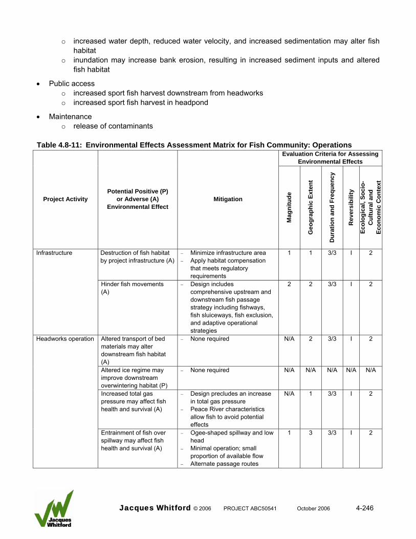
o increased water depth, reduced water velocity, and increased sedimentation may alter fish
habitat o inundation may increase bank erosion, resulting in increased sediment inputs and altered
fish habitat
• Public access o increased sport fish harvest downstream from headworks o increased sport fish harvest in headpond
• Maintenance o release of contaminants
Table 4.8-11: Environmental Effects Assessment Matrix for Fish Community: Operations
Evaluation Criteria for Assessing Environmental Effects
Project Activity Potential Positive (P)
or Adverse (A) Environmental Effect
Mitigation
Mag
nitu
de
Geo
grap
hic
Exte
nt
Dur
atio
n an
d Fr
eque
ncy
Rev
ersi
bilit
y
Ecol
ogic
al, S
ocio
- C
ultu
ral a
nd
Econ
omic
Con
text
Destruction of fish habitat by project infrastructure (A)
− Minimize infrastructure area − Apply habitat compensation
that meets regulatory requirements
1 1 3/3 I 2 Infrastructure
Hinder fish movements (A)
− Design includes comprehensive upstream and downstream fish passage strategy including fishways, fish sluiceways, fish exclusion, and adaptive operational strategies
2 2 3/3 I 2
Headworks operation Altered transport of bed materials may alter downstream fish habitat (A)
− None required N/A 2 3/3 I 2
Altered ice regime may improve downstream overwintering habitat (P)
− None required N/A N/A N/A N/A N/A
Increased total gas pressure may affect fish health and survival (A)
− Design precludes an increase in total gas pressure
− Peace River characteristics allow fish to avoid potential effects
N/A 1 3/3 I 2
Entrainment of fish over spillway may affect fish health and survival (A)
− Ogee-shaped spillway and low head
− Minimal operation; small proportion of available flow
− Alternate passage routes
1 3 3/3 I 2
Jacques Whitford © 2006 PROJECT ABC50541 October 2006 4-246
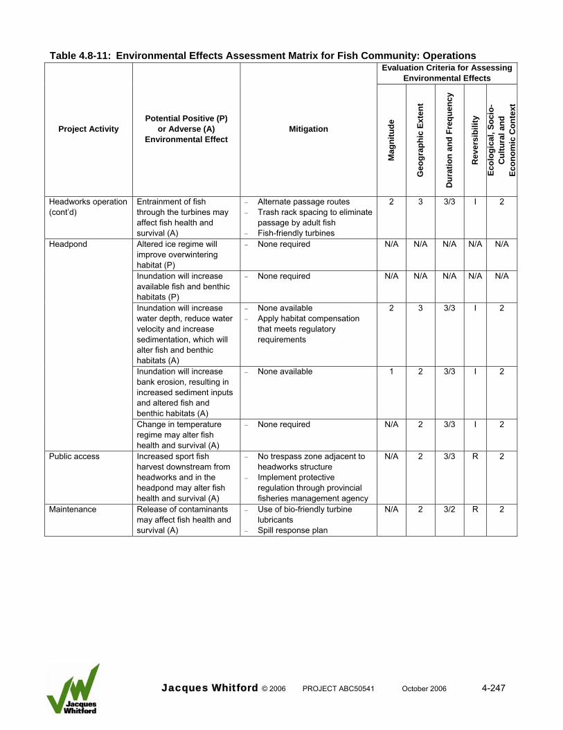
Table 4.8-11: Environmental Effects Assessment Matrix for Fish Community: Operations
Evaluation Criteria for Assessing Environmental Effects
Project Activity Potential Positive (P)
or Adverse (A) Environmental Effect
Mitigation
Mag
nitu
de
Geo
grap
hic
Exte
nt
Dur
atio
n an
d Fr
eque
ncy
Rev
ersi
bilit
y
Ecol
ogic
al, S
ocio
- C
ultu
ral a
nd
Econ
omic
Con
text
Headworks operation (cont’d)
Entrainment of fish through the turbines may affect fish health and survival (A)
− Alternate passage routes − Trash rack spacing to eliminate
passage by adult fish − Fish-friendly turbines
2 3 3/3 I 2
Headpond Altered ice regime will improve overwintering habitat (P)
− None required N/A N/A N/A N/A N/A
Inundation will increase available fish and benthic habitats (P)
− None required N/A N/A N/A N/A N/A
Inundation will increase water depth, reduce water velocity and increase sedimentation, which will alter fish and benthic habitats (A)
− None available − Apply habitat compensation
that meets regulatory requirements
2 3 3/3 I 2
Inundation will increase bank erosion, resulting in increased sediment inputs and altered fish and benthic habitats (A)
− None available 1 2 3/3 I 2
Change in temperature regime may alter fish health and survival (A)
− None required N/A 2 3/3 I 2
Public access Increased sport fish harvest downstream from headworks and in the headpond may alter fish health and survival (A)
− No trespass zone adjacent to headworks structure
− Implement protective regulation through provincial fisheries management agency
N/A 2 3/3 R 2
Maintenance Release of contaminants may affect fish health and survival (A)
− Use of bio-friendly turbine lubricants
− Spill response plan
N/A 2 3/2 R 2
Jacques Whitford © 2006 PROJECT ABC50541 October 2006 4-247
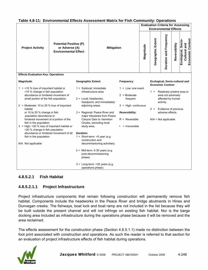
Table 4.8-11: Environmental Effects Assessment Matrix for Fish Community: Operations
Evaluation Criteria for Assessing Environmental Effects
Project Activity Potential Positive (P)
or Adverse (A) Environmental Effect
Mitigation
Mag
nitu
de
Geo
grap
hic
Exte
nt
Dur
atio
n an
d Fr
eque
ncy
Rev
ersi
bilit
y
Ecol
ogic
al, S
ocio
- C
ultu
ral a
nd
Econ
omic
Con
text
Effects Evaluation Key: Operations Magnitude: 1 = <10 % loss of important habitat or
<10 % change in fish population abundance or hindered movement of small portion of the fish population.
2 = Moderate: 10 to 20 % loss of important
habitat or 10 to 20 % change in fish
population abundance or hindered movement of a portion of the
fish in the population 3 = High: >20 % loss of important habitat or
>20 % change in fish population abundance or hindered movement of all fish in the population.
N/A Not applicable
Geographic Extent: 1 = Sublocal: immediate
infrastructure area 2 = Local: headworks,
headpond, and immediately adjoining areas.
3 = Regional: Peace River and
major tributaries from Peace Canyon Dam to Vermilion Chutes, excluding local study area.
Duration: 1 = Short-term: <5 year (e.g.
construction and decommissioning activities)
2 = Mid-term: 5-30 years (e.g.
post-decommissioning phase)
3 = Long-term: >30 years (e.g.
operations phase)
Frequency: 1 = Low: one event 2 = Moderate:
frequent 3 = High: continuous Reversibility: R = Reversible I = Irreversible
Ecological, Socio-cultural and Economic Context: 1 = Relatively pristine area or
area not adversely affected by human activity.
2 = Evidence of previous
adverse effects. N/A = Not applicable
4.8.5.2.1 Fish Habitat 4.8.5.2.1.1 Project Infrastructure Project infrastructure components that remain following construction will permanently remove fish habitat. Components include the headworks in the Peace River and bridge abutments in Hines and Dunvegan creeks. The fishways, boat lock and boat ramp are not included in the list because they will be built outside the present channel and will not infringe on existing fish habitat. Nor is the barge docking area included as infrastructure during the operations phase because it will be removed and the area reclaimed. The effects assessment for the construction phase (Section 4.8.5.1.1) made no distinction between the foot print associated with construction and operations. As such the reader is referred to that section for an evaluation of project infrastructure effects of fish habitat during operations.
Jacques Whitford © 2006 PROJECT ABC50541 October 2006 4-248
4.8.5.2.1.2 Altered Sediment Transport by Headworks The following summarizes information presented in MMA (2000a, and b, 2006) in relation to existing and predicted sediment transport in the Peace River in relation to the project headworks. Sediment transport in the Peace River is presently affected by flow regulation at the Bennett Dam and in general, the capacity of the river to transport larger materials (gravels and cobbles) has been reduced. In the project area, the post-Bennett Dam flow regime is generally incapable of mobilizing the surface armour and larger bed load material that originates from tributaries. The only major source of larger materials to the Peace River immediately upstream from the headworks is the Ksituan River; however, the fan at its confluence currently extends into the mainstem channel, which is an indication of the limited capacity of the Peace River to mobilize these materials. Sediment trapping in the proposed headpond will reduce the coarse textured sediment load to the downstream channel. Given that the Peace River presently has a limited capacity to move coarse-textured materials during most years and there are only limited amounts of these materials available to be mobilized, headworks operation will have a negligible effect on the present coarse-textured bed material transport regime. Channel conditions of the Peace River downstream from the headworks near Dunvegan Bridge indicate that an erosion resistant lag layer has developed, which could limit channel down cutting if it were to occur. The Project, therefore, is not expected to result in significant down cutting or a large increase in the size of the bed material armour layer downstream from the headworks as these changes have, to a large extent, already occurred due to the Bennett Dam. Analyses of sand-sized sediment transport indicate that substantial quantities of sand will be periodically deposited in the headpond and a portion of this material will be re-entrained during high flows. This will decrease the sand supply to the downstream channel, possibly reduce rates of sand-sized deposition along channel margins and could locally result in increased rates of re-entrainment of previously deposited sand materials. Given the large amount of sediment transport that presently exists, changes associated with the Project may be difficult to detect downstream from the headworks. Mitigation No mitigation is required due to the absence of detectable effects. Effects Evaluation Fish habitat in the project area is presently influenced by the sediment transport regime of the Peace River. Coarse materials are not easily transported and sands dominate the channel margins, whereas mid-channel areas contain embedded gravel and cobble materials. Given the present lack of larger-sized materials moving through the system combined with the large quantities of sand that is being transported, the incremental changes caused by the Project will have negligible effects on fish habitat downstream from the Project. These effects relate to transport of larger-sized materials, down cutting of the river channel and deposition and mobilization of smaller sized materials.
Jacques Whitford © 2006 PROJECT ABC50541 October 2006 4-249
4.8.5.2.1.3 Altered Ice Regime by the Headworks The following summarizes information presented in NHC (2006a) in relation to existing and predicted ice production and transport in the Peace River in relation to the Project. Under present conditions, ice formation in the project area is controlled by flow regulation by the Bennett Dam. Extensive frazil ice production in the upper Peace River causes formation of an unconsolidated ice sheet, which can attain a thickness of approximately 3.0 m. The presence of the headworks will create an open water zone downstream from the facility by eliminating formation of the unconsolidated ice sheet and production of frazil ice. Modelling suggests that the open water area will extend between 10 and 90 km downstream from the headworks depending on the year with a predicted average of 40 km. The facility will cause formation of anchor ice (i.e., bottom-fast ice) in the tailrace zone. Depending on the air temperature, winter period, and distance downstream, anchor ice thickness would range from 5 to 25 cm. Anchor ice would form on the river bottom in high velocity zones rather than calm water areas adjacent to the channel margin or downstream from islands. Mitigation No mitigation is required due to the altered ice regime having a positive effect. Effects Analysis The effects of an altered ice regime on fish habitat will be positive due to improvement in the amount and quality of overwintering habitat downstream from the headworks. Overwintering habitats used by large fish in the Peace River can be characterized by deep water, low velocity areas that provide protection from solid ice (surface ice, anchor ice) and frazil ice (Hildebrand 1990; Pattenden 1993; Power et al. 1993; Brown et al. 1994). Smaller fish, such as cyprinids, also seek protection within interstitial spaces provided by rock substrates in areas that are not subjected to freezing or damage from ice (Cunjak and Power 1986). In general, overwintering fish are closely associated with river edges and protected areas that provide refugia from high flows, as has been demonstrated by Whalen and Parrish (1999). Based on the characteristics described above, overwintering habitats presently available to large and small fish are limited in the project area due to the presence of the thick, unconsolidated ice sheet and frazil ice. The absence of an unconsolidated ice sheet and frazil ice production immediately downstream from the facility will improve overwintering habitat for fish over what presently exists. As such, the headworks operation will have a positive effect on downstream fish habitat. It is unknown to what extent the modified ice regime will improve fish habitat; therefore, the importance of this positive effect cannot be quantified. 4.8.5.2.1.4 Headpond Formation Existing Conditions The characteristics of the Peace River and its tributaries affect fish habitats in the project area. Several factors that have a major influence on fish habitat were described in Section 4.8.2, but are repeated here for clarity.
Jacques Whitford © 2006 PROJECT ABC50541 October 2006 4-250
The Peace River is subjected to flow regulation by the Bennett Dam in British Columbia. Peak annual flows are reduced while there are large diurnal fluctuations in flow. According to Prowse and Conly (1996) flow regulation of the Peace River has affected the fish community as follows: • an altered temperature regime that has permitted cold-water species to extend their downstream
limit of distribution
• a reduced capacity to transport sediments, which has caused a narrowing of the river channel and altered habitats
• an ice regime that severely restricts the availability of overwintering habitat
• diurnal fluctuations in water level that reduces the availability of habitats The Peace River has a high sediment load (MMA 2000a). Post-Bennett Dam suspended sediment concentrations in the project area have ranged as high as 4 730 mg/L. The associated daily suspended sediment load was estimated to be 1.3 Mt/d. Suspended sediment concentrations (and turbidity levels) tend to be highest in spring and decline throughout summer and fall. These constituents regularly exceed the CWQG criteria, particularly in spring. There is a generally accepted body of literature that demonstrates the severity of effects of suspended solids on fish increases as a function of both sediment concentration and duration of exposure (Anderson et al. 1995; Newcombe and Jensen 1996). High suspended sediment loads can also affect other aquatic biota; for example, high TSS levels can result in abrasion of benthic algal communities and decreased light penetration, both of which result in reduced primary productivity (Stevenson et al. 1996). The sediment concentration and duration of exposure in the Peace River presently exceed the threshold deemed to cause adverse effects. The tributaries flowing into the Peace River in the project area have been influenced by land-use activities such as agriculture and logging. Stream flow in the tributaries is highly variable, with extreme discharge occurring in spring or during large rainfall events, followed by subsequent intermittent or zero flow conditions. This discharge regime has reduced the quality and availability of fish habitats. These effects have influenced the structure of the fish community that resides in the project area. Fish populations that require tributary habitats for spawning and rearing purposes during summer and fall are severely restricted. Similarly, the tributaries cannot provide overwintering habitat for fish or areas of refuge from adverse conditions in the mainstem Peace River. Existing Fish Habitats Existing fish habitats were described in terms of their quality and quantity during the 1999 investigation (RL&L 2000b). The information was supplemented by additional field investigations completed in 2000 that examined specific habitat sites within the project area (Glacier 2001, MMA 2001). This work was followed by a detailed evaluation of habitat losses and gains in preparation for a No Net Loss Habitat Plan for the Project (Mainstream 2006c). The survey methods used during each study are described in the respective documents. The following summarizes the general findings. The results of field investigations show that fish habitat in the Peace River in the project area is uniform and exhibits low complexity. In general, riverbank mesohabitats provide limited amounts of cover for fish, and unique instream mesohabitats are restricted in distribution. Backwaters that provide protected,
Jacques Whitford © 2006 PROJECT ABC50541 October 2006 4-251
low velocity areas for fish, although present, are not abundant. Shoal and riffle or rapid habitats that could potentially be used for feeding and spawning purposes are present, but they provide small amounts of habitat relative to other lower quality habitats such as deep exposed Runs. No protected snyes or side channels are present under existing flows. Also, several areas of the active channel do not become inundated under the present flow regime. The mainstem Peace River provides limited amounts of high-quality fish habitat. The channel is relatively shallow throughout, which limits its potential as overwintering habitat, and water velocities are generally high. There is a paucity of instream cover, as a result of smooth riverbanks and channel bottom (caused by embedded large-textured materials). As such, habitats that provide refuge from high water velocities are not abundant. This situation is exacerbated by daily fluctuations in the flow regime that further reduce the quality of available habitat. Tributaries in the headpond area include the Ksituan River and Hamelin Creek. They are characterized by variable flows. In summer and fall habitat is frequently limited to isolated pools with no surface connection to the mainstem Peace River. Channel characteristics of project area tributaries indicate that they are subject to significant flow events and extensive bedload movement. Stream channels are laterally unstable as evidenced by extensive bank erosion. Due to low (spring) and negligible flows (summer and fall), an absence of deep-water habitat capable of supporting overwintering fish, and the prevalence of fine substrates, the tributaries provided poor habitat for most fish species. Resident stream populations were not recorded and the tributaries had limited value to sport and non-sport fish populations originating from in the mainstem Peace River. However, the tributaries did provide seasonal habitat for cyprinid and sucker species. Two important habitats were found in the project area during the 1999 and 2004 investigations. A walleye spawning site was identified at a shoal within the proposed headpond area. A small number of fish (9) in spawning condition and walleye eggs were recorded at the site in 1999. The shoal consisted of unconsolidated gravels and cobbles that were not unfilled by sediments. Walleye in spawning condition (9 fish) were recorded at the site again in 2004. Although used for spawning, the shoal is subjected to dewatering due to flow regulation. In 1999, the shoal and incubating walleye eggs were dewatered. In 1999, a northern pike spawning area was in the proposed headpond area adjacent to a nonactive side channel of the Peace River. Northern pike appeared to be using submerged shoreline vegetation as spawning substrate. Flow regulation caused the site to dewater shortly after it was identified. A subsequent survey in 2004 established that the site was completely destroyed by ice scour caused by the unconsolidated ice sheet during winter of 2003–04. Longnose sucker, white sucker, and a number of cyprinid species used tributary habitats in the project area for spawning and rearing. These included areas in Hines and Dunvegan creeks and the Ksituan River. Fish habitat quantity and quality were quantified in order to evaluate habitat losses and gains associated with the Project using the Habitat Suitability Matrix protocol (Mainstream 2006c). A summary of exiting fish habitat type, number, and surface area potentially affected by the headpond is presented in Tables 4.8-12 and 4.8-13. In the headpond, the majority of existing instream habitats consist of deep run (93 percent by area) interspersed with small, discrete units of shoal (2 percent) and
Jacques Whitford © 2006 PROJECT ABC50541 October 2006 4-252
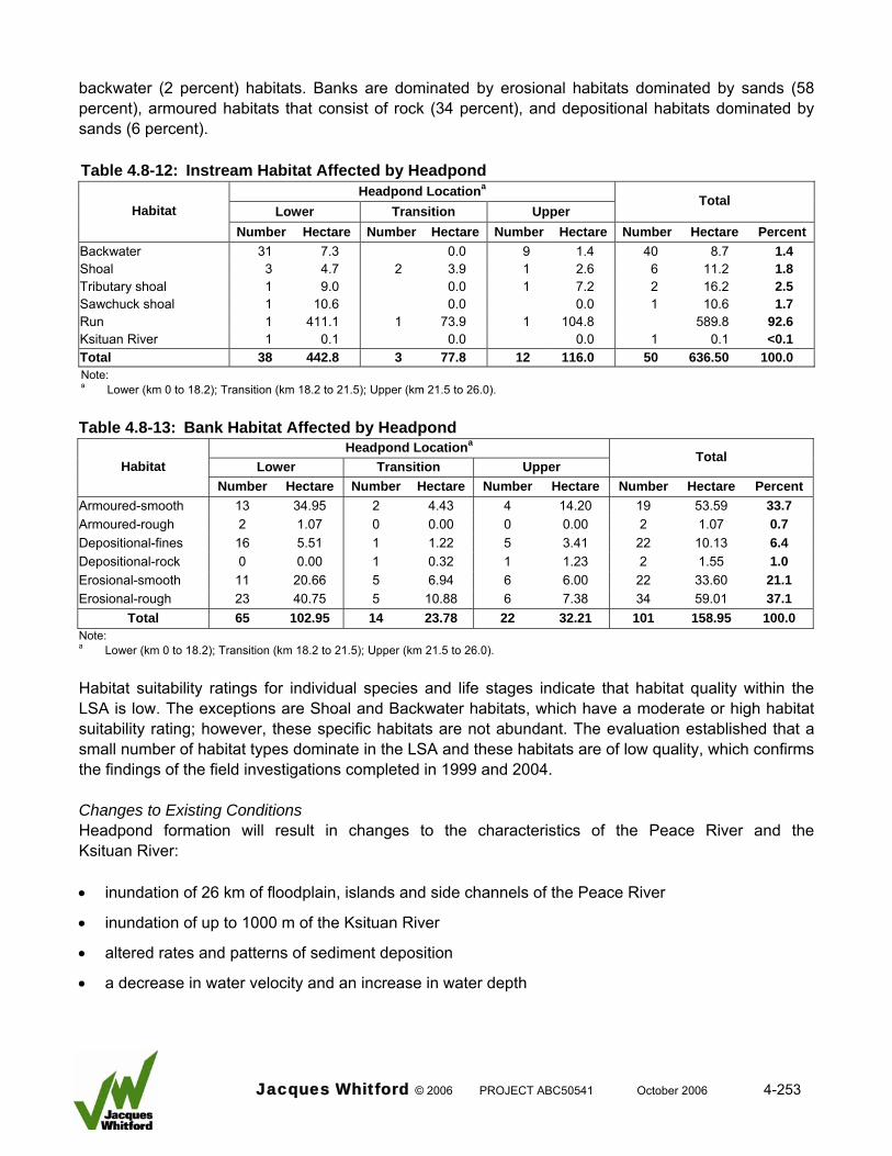
backwater (2 percent) habitats. Banks are dominated by erosional habitats dominated by sands (58 percent), armoured habitats that consist of rock (34 percent), and depositional habitats dominated by sands (6 percent). Table 4.8-12: Instream Habitat Affected by Headpond
Headpond Locationa
Lower Transition Upper Total
Habitat Number Hectare Number Hectare Number Hectare Number Hectare Percent
1.4 Backwater 31 7.3 0.0 9 1.4 40 8.7 1.8 Shoal 3 4.7 2 3.9 1 2.6 6 11.2 2.5 Tributary shoal 1 9.0 0.0 1 7.2 2 16.2 1.7 Sawchuck shoal 1 10.6 0.0 0.0 1 10.6
Run 1 411.1 1 73.9 1 104.8 589.8 92.6 Ksituan River 1 0.1 0.0 0.0 1 0.1 <0.1 Total 38 442.8 3 77.8 12 116.0 50 636.50 100.0 Note: a Lower (km 0 to 18.2); Transition (km 18.2 to 21.5); Upper (km 21.5 to 26.0). Table 4.8-13: Bank Habitat Affected by Headpond
Headpond Locationa
Lower Transition Upper Total
Habitat Number Hectare Number Hectare Number Hectare Number Hectare Percent
Armoured-smooth 13 34.95 2 4.43 4 14.20 19 53.59 33.7 Armoured-rough 2 1.07 0 0.00 0 0.00 2 1.07 0.7 Depositional-fines 16 5.51 1 1.22 5 3.41 22 10.13 6.4 Depositional-rock 0 0.00 1 0.32 1 1.23 2 1.55 1.0 Erosional-smooth 11 20.66 5 6.94 6 6.00 22 33.60 21.1 Erosional-rough 23 40.75 5 10.88 6 7.38 34 59.01 37.1
Total 65 102.95 14 23.78 22 32.21 101 158.95 100.0 Note: a Lower (km 0 to 18.2); Transition (km 18.2 to 21.5); Upper (km 21.5 to 26.0). Habitat suitability ratings for individual species and life stages indicate that habitat quality within the LSA is low. The exceptions are Shoal and Backwater habitats, which have a moderate or high habitat suitability rating; however, these specific habitats are not abundant. The evaluation established that a small number of habitat types dominate in the LSA and these habitats are of low quality, which confirms the findings of the field investigations completed in 1999 and 2004. Changes to Existing Conditions Headpond formation will result in changes to the characteristics of the Peace River and the Ksituan River: • inundation of 26 km of floodplain, islands and side channels of the Peace River
• inundation of up to 1000 m of the Ksituan River
• altered rates and patterns of sediment deposition
• a decrease in water velocity and an increase in water depth
Jacques Whitford © 2006 PROJECT ABC50541 October 2006 4-253
The only other named tributary potentially affected by headpond formation is Hamelin Creek. Because this tributary is at the upstream extent of the headpond it will not be affected by inundation. The Project will increase the existing water level in the Peace River by 5.4 to 7.6 m (MSA 2005). Under normal operating conditions headpond water elevation will be maintained at 347.9 m, which will cause a maximum water depth of 10.9 m at the headworks. Headpond effects on water depth will progressively decrease until they are within 0.5 m of the present daily water level fluctuations 26 km upstream from the headworks. MMA (2006) discusses predicted changes in water velocities in the headpond calculated by MSA (2005). A HEC RAS model was used to calculate the average cross-section velocity in the headpond for a range of flows. The 90 percent exceedance flows of the Peace River range from 250 to 905 m³/s. The associated average water velocity ranges from 1.1 to 1.8 m/s. The Project will decrease water velocities associated with the 90 percent exceedance flow by 0.3 m/s at km 26 and by 0.9 m/s near the headworks. The 50 percent exceedance flows of the Peace River range from 822 to 1,540 m³/s, average water velocities are 1.2 to 1.3 m/s at most locations. The Project will reduce the associated water velocities downstream from approximately km 24 with velocities being 1.1 m/s (km 24) to 0.4 m/s (km 0). Flood flow water velocities also would be reduced by headpond formation. The 2 year flood flow water velocities would decrease from approximately 1.9 m/s to 1.6 at km 22 to 0.4 m/s (km 0). For a 5 year flood event, velocities would decrease from approximately 2.2 m/s to 1.8 at km 22 to 0.4 m/s (km 0). The reduction in water velocities will result in increased deposition. Based on these data MMA (2006) suggested that the majority of the headpond would become sand bedded, with the transition zone from gravel to sand being between km 20 and km 23. The computer program GSTAR3 was used to provide more detailed information on sediment transport through the headpond and to better estimate potential rates of long-term sediment deposition. Analyses undertaken by Northwest Hydraulic Consultants Ltd. are discussed in MMA (2006) The GSTARS modelling results indicate that predicted sediment accumulations in the headpond after 10 years of operations would be: • all of the incoming gravel load is deposited in the upstream end of the headpond, mainly upstream
from km 18
• virtually all of the medium and coarse sand (0.2 mm to 2 mm) is deposited in the headpond, with most deposition occurring between km 8 and km 18
• virtually all of the fine sand (0.0625 mm to 0.2 mm) is deposited in the headpond, with most of the deposition occurring between station km 4 and km 18
• a small fraction of the silt (4.9 percent) is deposited in the headpond with most of this deposition occurring near the headworks between km 6 and km 0
The GSTARS modelling results indicate, as discussed in MMA (2006), that the predicted sediment accumulations in the headpond up to 50 years of operations would be:
Jacques Whitford © 2006 PROJECT ABC50541 October 2006 4-254
• Sand and fine pea-gravel is deposited in the headpond and the resulting sediment wedge advances
towards the dam as a delta front. The rate of deposition decreases after about 30 years, indicating a significant fraction of the sediments starts to be flushed through the headpond after this time. Over the 50 year period, silt and clay size sediments make up a very small fraction of the deposited sediments (0.4 percent) even though these sizes make up the majority of the total sediment inflow (greater than 80 percent). This indicates over a 50 year time span, the silt and clay size sediments will behave as “wash load” and will be flushed though the channel without remaining on the bed.
. • Upstream from km 18, the accumulated deposits consist mainly of gravel and sand. Comparison
with results from Year 10 show the deposited sediments in the upper end of the headpond become coarser over time, indicating that gravel bed load eventually starts to prograde over the finer sandy deposits. Given sufficient time, the river will eventually return to a gravel bed channel, if there is a significant supply of gravel sediments to the system.
• Most of the sediments deposited downstream from km 18 consist of medium to fine sand. • The total volume of sediment deposited in the headpond after 50 years is calculated to be 35 x
106 m³, which represents 11.6 percent of the incoming sediment load. The average annual sediment deposition volume is 700,000 m³.
Changes to Existing Fish Habitats Based on this information changes to the fluvial characteristics of Peace River and Ksituan River will alter, but will not destroy existing fish habitats. Some of the predicted changes will have a negative effect, while others can be considered positive. Inundation will increase the area of habitat available to fish by approximately 100 ha. This increase will occur along the river margins and in side channels that are currently dry or that are dewatered under the present flow regime. This can be viewed as a positive effect. The increase in water depth and reduction in water velocity will enhance overwintering habitat for larger-sized fish by providing a large area that is not affected by the unconsolidated ice sheet where fish can reside with minimal energy expenditures. The area with greatest benefit would extend from the headworks to approximately 6 km upstream. This can be viewed as a positive effect because overwintering habitat is very limited in the project area. Coarse-textured materials (gravels and cobbles) will be deposited in an area at the upstream end of the headpond. It is expected that the deposition zone will provide spawning habitat that is of similar quality to the shoal that currently exists at km 17. The timing for such a shoal to form and the surface area of the shoal cannot be reliably calculated, but it is expected to develop within 10 years of headpond formation and could extend over a distance of 5 km. This can be viewed as a positive effect because shoal habitat is limited in the project area. Increased water depth, reduced water velocity and increased sedimentation will alter the characteristics of certain fish habitats to the point where they may no longer retain their original function. This may be a negative effect associated with headpond formation. Headpond locations that will be altered include existing shoals (shallow-water areas with gravel and cobble materials) that are potential spawning
Jacques Whitford © 2006 PROJECT ABC50541 October 2006 4-255
areas for some species, as well as feeding for all fish species. Included in the affected area is a known walleye spawning site at km 17 that that is expected to infill with fine sediments. Bank areas that are characterized by deep water (backwater habitats) and bank irregularities, which are considered good quality habitat, also will be affected by the altered flow regime. Over the long term (50 years), channel margins are predicted to become more uniform in the lower section of the headpond due to infilling with sands. Similar changes will occur to fish habitat in the 1000 m section of the Ksituan River, which currently consists entirely of riffle and boulder garden habitat. Over an extended period of time, the majority of the inundated section may infill with sediments until equilibrium is reached with the water elevation of the headpond (MMA 2001). A change in sediment quality that would affect benthic communities is not expected; however, the predicted change in the particle size and spatial manner in which sediment is deposited in the headpond (i.e., more coarse material in the most upstream segment of the headpond and more finer material in the downstream portion of the headpond) is expected to result in a shift to the benthic community composition. These predictions of changes in physical habitat within the headpond (physical habitat for benthic communities affected by the Project is defined functionally as substrate particle size and water velocity) will result in changes in the taxonomic composition because of the association between life history requisites of many taxa and these physical parameters. The benthic community in the first 15 km upstream from the headworks is expected to become more characteristic of that associated with slower flowing water and finer particle size than what currently dominates. Similar changes will occur to habitat in the 1 km section of the Ksituan River, which currently contains an abundance of gravel and cobble materials. By analogy, once the Project is in operation, the benthic community is expected to evolve to that currently found near Carcajou, a reach of the Peace River downstream from Dunvegan with substrate and water velocity conditions consistent with those predicted for the downstream portion of the project headpond. Past synoptic sampling programs have estimated invertebrate densities near the Project (i.e., upstream from the confluence of the Smoky River to the British Columbia–Alberta border) as being approximately twice those of the Carcajou reach of the Peace River. Following the logic outlined above, it is possible that invertebrate densities could decrease in areas of the headpond where smaller-grained sediment is expected to deposit. A potential positive effect of the Project is the deposition of coarser materials at the upstream end of the headpond that could provide additional habitat for hard substrate benthic communities. An increase in the wetted surface area caused by headpond inundation of presently dry channel sections may also benefit the benthic communities by increasing the overall availability of habitat. Losses versus Gains Changes to fish habitat caused by headpond formation were evaluated based on losses versus gains using the habitat assessment completed as part of the No Net Loss Plan for the Project (Mainstream (2006c). The following summarizes the results of that assessment, which is followed by the effects evaluation. The approach used to calculate the losses and gains balance for the Project is a modification of the Habitat Suitability Matrix (HSM) protocol (Minns et al. 2001). The approach uses the habitat suitability index (HSI) as a measure of habitat quality. The HSI value is assigned based on criteria that describe
Jacques Whitford © 2006 PROJECT ABC50541 October 2006 4-256
physical characteristics that affect habitat quality (e.g., depth, velocity, and bed material). It is a standardized categorical value that rates the quality of a particular habitat type for specific species and life stage. The HSI value is multiplied by the surface area of the affected habitat to generate a standardized habitat unit. Each standardized habitat unit is then weighted by a species-specific importance value. The weighted habitat units (WHUs) are then summed to generate the net change in habitat. This number is the basis for the loss versus gains balance. For the purposes of this assessment, it is assumed that bank fish habitats and instream fish habitats will be equally affected by formation of the headpond. Initially bank habitats will be displaced higher up the channel margins following inundation, and over the short-term, they will maintain the characteristics that dictate their value to fish. As the channel morphology of the Peace River in the headpond and Ksituan River adjusts to the new flow regime, bank habitats are predicted to become more uniform in the lower 18 km section of the headpond due to infilling of channel margins with sand. Predicted 50 percent exceedance flows were used to evaluate changes to existing fish habitats. This approach was deemed appropriate because this represented average conditions expected to occur in the headpond. Hydraulic characteristics of the headpond at 50 percent exceedance flows (i.e., water depth, water velocity, and shear stress) and the probability for sand deposition described in MMA (2006) were used to delineate the headpond into habitat zones. The headpond was divided into three general habitat zones. In the Lower Zone (km 0 to 18.2) increased water depths, decreased water velocities, and increased sand deposition would potentially alter all habitats. The available instream habitat would consist mainly of deep slow Run and available bank habitat would transform to Depositional areas that contain sands. There would be a short Transition Zone from km 18.2 to 21.5, where habitat conditions would be in a continual state of change. During average flows (50 percent exceedance) sand deposition would occur, while higher flows equal to or greater than 50 percent exceedance would cause alterations by remobilizing deposited sand materials. For the purposes of the assessment it is conservatively assumed that existing habitats in the Transition Zone would be altered. They would become more uniform due to deposition of sand along the channel margin and an increase in water depth. The water depth and water velocities in the Upper Zone of the headpond (km 21.5 to 26.0) at 50 percent exceedance would remain generally the same; therefore, it was assumed that habitat conditions in this section would not change. Habitats that potentially could be inundated by the headpond, or new habitats, were included in the assessment. Each potential habitat unit was evaluated based on the probability of inundation (at 50 percent exceedance) and the frequency and extent of sediment deposition. Dominant bed material (rock versus sand) expected to occur in the habitat polygon following inundation was used to define habitat type. The assessment included a detailed evaluation of important habitats that presently exist in the headpond area. The shoal locally known as Sawchuck Rapids at km 17 of the headpond (21.2 ha) provides important fish habitat because a portion of the shoal is a confirmed spawning area for walleye. The dimensions and surface elevations of the shoal were mapped and the information used to generate a surface contour map of the shoal at 0.25 m intervals. To delineate potential walleye spawning habitat
Jacques Whitford © 2006 PROJECT ABC50541 October 2006 4-257
provided by the shoal, a hydraulic assessment was completed of the shoal during the expected walleye spawning period. Based on these results, the area of potential walleye spawning habitat was delineated using the predicted mean elevation of 345.62 m (1776 m3/s). The contour data, the predicted mean water level elevation, and physical characteristics of the shoal were then used to delineate the potential walleye spawning habitat provided by the shoal. Using established criteria to define walleye spawning habitat (McMahon et al. 1984) the surface area of potential walleye spawning habitat provided by Sawchuck Shoal at a water elevation of 345.62 m was 10.58 ha. The entire 10.58 ha habitat unit was given a high habitat suitability rating for walleye spawning because:
• it met established criteria for walleye spawning habitat
• the area was used by walleye for spawning
• it was the best available habitat in the project area The high rating was provided despite the fact that walleye did not use the entire area for spawning and fluctuations in water level precluded spawning on portions of the shoal (RL&L 2000b). The conservative approach used to rate walleye spawning habitat quality was adopted because the spatial extent of walleye spawning activity on the shoal over the long-term could not be delineated.
Finally, it is worth noting that coarse textured materials (gravels and cobbles) will be deposited at the extreme upstream end of the headpond (MMA 2006). This zone could provide spawning habitat that is of similar quality to the walleye spawning shoal that presently exists at km 17 of the headpond. The timing for such a shoal to form and the surface area of the shoal cannot be reliably calculated, but it is expected to develop within 10 years of headpond formation and could extend over a distance of 5 km (MMA 2001). Even though this area has the potential to provide important fish habitat (e.g., walleye spawning area) it is not included in the assessment because there is low certainty regarding the quantity of habitat that would be created. The total area of existing habitat affected by headpond inundation would be 785.7 ha (Table 4.8-14). Of this total, the amount of affected area would be highest for instream habitats (626.0 ha), and bank habitats (149.2 ha). Affected areas would be primarily in the Peace River (785.6 WHU), with a very small area occurring in the Ksituan River (0.10 ha).
Jacques Whitford © 2006 PROJECT ABC50541 October 2006 4-258
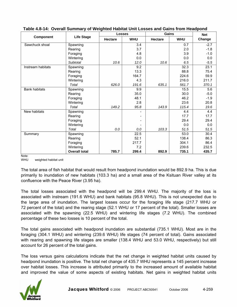
Table 4.8-14: Overall Summary of Weighted Habitat Unit Losses and Gains from Headpond
Losses Gains Component Life Stage Hectare WHU Hectare WHU
Net Change
Sawchuck shoal Spawning 3.4 0.7 -2.7 Rearing 3.7 2.0 -1.8 Foraging 4.8 3.9 -1.0 Wintering 0.0 0.0 0.0 Subtotal 10.6 12.0 10.6 6.5 -5.5
Instream habitats Spawning 9.2 32.3 23.1 Rearing 13.3 88.8 75.4 Foraging 164.7 224.6 59.9 Wintering 4.3 216.0 211.7 Total 626.0 191.6 635.1 561.7 370.1 Bank habitats Spawning 9.9 15.5 5.6 Rearing 35.0 30.0 -5.0 Foraging 48.1 46.2 -1.9 Wintering 2.8 23.6 20.8 Total 149.2 95.8 143.9 115.4 19.6 New habitats Spawning - 4.4 4.4 Rearing - 17.7 17.7 Foraging - 29.4 29.4 Wintering - 0.0 0.0
Total 0.0 0.0 103.3 51.5 51.5 Summary Spawning 22.5 53.0 30.4 Rearing 52.1 138.4 86.3 Foraging 217.7 304.1 86.4 Wintering 7.2 239.6 232.5
Overall total 785.7 299.4 892.9 735.1 435.7 Note: WHU weighted habitat unit The total area of fish habitat that would result from headpond inundation would be 892.9 ha. This is due primarily to inundation of new habitats (103.3 ha) and a small area of the Ksituan River valley at its confluence with the Peace River (3.95 ha). The total losses associated with the headpond will be 299.4 WHU. The majority of the loss is associated with instream (191.6 WHU) and bank habitats (95.8 WHU). This is not unexpected due to the large area of inundation. The largest losses occur for the foraging life stage (217.7 WHU or 72 percent of the total) and the rearing stage (52.1 WHU or 17 percent of the total). Smaller losses are associated with the spawning (22.5 WHU) and wintering life stages (7.2 WHU). The combined percentage of these two losses is 10 percent of the total. The total gains associated with headpond inundation are substantial (735.1 WHU). Most are in the foraging (304.1 WHU) and wintering (239.6 WHU) life stages (74 percent of total). Gains associated with rearing and spawning life stages are smaller (138.4 WHU and 53.0 WHU, respectively) but still account for 26 percent of the total gains. The loss versus gains calculations indicate that the net change in weighted habitat units caused by headpond inundation is positive. The total net change of 435.7 WHU represents a 145 percent increase over habitat losses. This increase is attributed primarily to the increased amount of available habitat and improved the value of some aspects of existing habitats. Net gains in weighted habitat units
Jacques Whitford © 2006 PROJECT ABC50541 October 2006 4-259
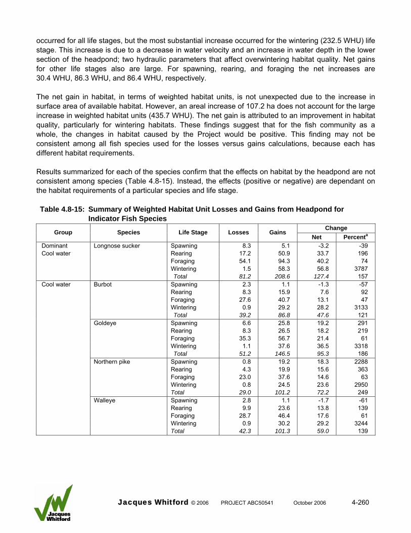
occurred for all life stages, but the most substantial increase occurred for the wintering (232.5 WHU) life stage. This increase is due to a decrease in water velocity and an increase in water depth in the lower section of the headpond; two hydraulic parameters that affect overwintering habitat quality. Net gains for other life stages also are large. For spawning, rearing, and foraging the net increases are 30.4 WHU, 86.3 WHU, and 86.4 WHU, respectively. The net gain in habitat, in terms of weighted habitat units, is not unexpected due to the increase in surface area of available habitat. However, an areal increase of 107.2 ha does not account for the large increase in weighted habitat units (435.7 WHU). The net gain is attributed to an improvement in habitat quality, particularly for wintering habitats. These findings suggest that for the fish community as a whole, the changes in habitat caused by the Project would be positive. This finding may not be consistent among all fish species used for the losses versus gains calculations, because each has different habitat requirements. Results summarized for each of the species confirm that the effects on habitat by the headpond are not consistent among species (Table 4.8-15). Instead, the effects (positive or negative) are dependant on the habitat requirements of a particular species and life stage. Table 4.8-15: Summary of Weighted Habitat Unit Losses and Gains from Headpond for
Indicator Fish Species Change
Group Species Life Stage Losses Gains Net Percenta
Dominant Longnose sucker Spawning 8.3 5.1 -3.2 -39 Cool water Rearing 17.2 50.9 33.7 196 Foraging 54.1 94.3 40.2 74 Wintering 1.5 58.3 56.8 3787 Total 81.2 208.6 127.4 157 Cool water Burbot Spawning 2.3 1.1 -1.3 -57 Rearing 8.3 15.9 7.6 92 Foraging 27.6 40.7 13.1 47 Wintering 0.9 29.2 28.2 3133 Total 39.2 86.8 47.6 121 Goldeye Spawning 6.6 25.8 19.2 291 Rearing 8.3 26.5 18.2 219 Foraging 35.3 56.7 21.4 61 Wintering 1.1 37.6 36.5 3318 Total 51.2 146.5 95.3 186 Northern pike Spawning 0.8 19.2 18.3 2288 Rearing 4.3 19.9 15.6 363 Foraging 23.0 37.6 14.6 63 Wintering 0.8 24.5 23.6 2950
Total 29.0 101.2 72.2 249 Walleye Spawning 2.8 1.1 -1.7 -61 Rearing 9.9 23.6 13.8 139 Foraging 28.7 46.4 17.6 61 Wintering 0.9 30.2 29.2 3244 Total 42.3 101.3 59.0 139
Jacques Whitford © 2006 PROJECT ABC50541 October 2006 4-260
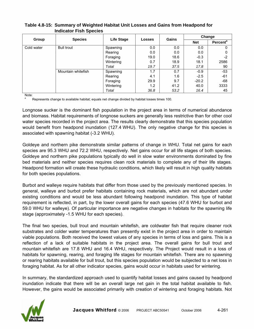
Table 4.8-15: Summary of Weighted Habitat Unit Losses and Gains from Headpond for
Indicator Fish Species Change
Group Species Life Stage Losses Gains Net Percenta
Cold water Bull trout Spawning 0.0 0.0 0.0 0 Rearing 0.0 0.0 0.0 0 Foraging 19.0 18.6 -0.3 -2 Wintering 0.7 18.9 18.1 2586 Total 19.7 37.5 17.8 90 Mountain whitefish Spawning 1.7 0.7 -0.9 -53 Rearing 4.1 1.6 -2.5 -61 Foraging 29.9 9.7 -20.2 -68 Wintering 1.2 41.2 40.0 3333 Total 36.8 53.2 16.4 45 Note: a Represents change to available habitat; equals net change divided by habitat losses times 100.
Longnose sucker is the dominant fish population in the project area in terms of numerical abundance and biomass. Habitat requirements of longnose suckers are generally less restrictive than for other cool water species recorded in the project area. The results clearly demonstrate that this species population would benefit from headpond inundation (127.4 WHU). The only negative change for this species is associated with spawning habitat (-3.2 WHU). Goldeye and northern pike demonstrate similar patterns of change in WHU. Total net gains for each species are 95.3 WHU and 72.2 WHU, respectively. Net gains occur for all life stages of both species. Goldeye and northern pike populations typically do well in slow water environments dominated by fine bed materials and neither species requires clean rock materials to complete any of their life stages. Headpond formation will create these hydraulic conditions, which likely will result in high quality habitats for both species populations. Burbot and walleye require habitats that differ from those used by the previously mentioned species. In general, walleye and burbot prefer habitats containing rock materials, which are not abundant under existing conditions and would be less abundant following headpond inundation. This type of habitat requirement is reflected, in part, by the lower overall gains for each species (47.6 WHU for burbot and 59.0 WHU for walleye). Of particular importance are negative changes in habitats for the spawning life stage (approximately -1.5 WHU for each species). The final two species, bull trout and mountain whitefish, are coldwater fish that require cleaner rock substrates and colder water temperatures than presently exist in the project area in order to maintain viable populations. Both received the lowest values of any species in terms of loss and gains. This is a reflection of a lack of suitable habitats in the project area. The overall gains for bull trout and mountain whitefish are 17.8 WHU and 16.4 WHU, respectively. The Project would result in a loss of habitats for spawning, rearing, and foraging life stages for mountain whitefish. There are no spawning or rearing habitats available for bull trout, but this species population would be subjected to a net loss in foraging habitat. As for all other indicator species, gains would occur in habitats used for wintering. In summary, the standardized approach used to quantify habitat losses and gains caused by headpond inundation indicate that there will be an overall large net gain in the total habitat available to fish. However, the gains would be associated primarily with creation of wintering and foraging habitats. Not
Jacques Whitford © 2006 PROJECT ABC50541 October 2006 4-261
all indicator species will benefit equally from the habitat gains. Species that require rock materials to complete some of their life requisites would be most affected. Mitigation None are available for modification of headpond formation. Fish habitat compensation described in Mainstream (2006c) that is acceptable to regulatory authorities (DFO and ASRD) will be completed to offset alteration to fish habitats caused by headpond formation and other project effects. Physical compensation will include development of approximately 11 ha of northern pike spawning and rearing habitat in the headpond area. Additional compensation will include a study designed to delineate important habitats used by the Little Smoky River walleye population. This information will aid in the management objectives for that population, which likely will benefit Peace River walleye populations (Walty, pers. comm.). The planned habitat compensation was derived in consultation with regulatory authorities. It is deemed an appropriate mitigation measure to offset effects on fish habitat caused by headpond formation. From an ecological perspective, however, habitat compensation cannot be considered full mitigation because certain species and life stages would still be adversely affected. Effects Evaluation The overall effects of headpond formation on fish habitat is deemed to be positive due to the large increase in habitat available to fish and an increase in certain habitats that are presently limiting in the project area (overwintering). However, habitats containing rock materials would be adversely affected due to deposition of sands. This change to existing conditions would adversely affect species that require those types of habitats. The species and life stages adversely affected are: • longnose sucker (3.4 WHU [39 percent of available spawning habitat]) • burbot (1.3 WHU [57 percent of available spawning habitat]) • walleye (1.7 WHU [61 percent of available spawning habitat]) • bull trout (0.3 WHU [2 percent of available foraging habitat]) • mountain whitefish (0.9 WHU [53 percent of available spawning habitat]; 2.5 WHU [61 percent of
available rearing habitat]; 20.2 WHU [68 percent of available foraging habitat) Based on these predicted changes there will be an adverse effect on fish habitat caused by headpond formation. The consequences of changes to fish habitat in the headpond to most fish populations are considered minor (see Section 4.8.8.2). This is because fish in this area of the Peace River are pre-adapted to the predicted headpond conditions and habitats that are unaffected by the headpond are available to fish immediately upstream and downstream from the effected zone. 4.8.5.2.1.5 Increased Bank Erosion due to Headpond Formation The following summarizes information presented in MMA (2006) and AMEC (2004) regarding the potential for bank erosion or channel bank stability following headpond formation. Post-project water levels are below the two-year return period pre-Bennett Dam levels throughout the upper 9 km of the headpond. Within this upper area, raised water levels will cause some inundation of low-lying areas; however, the inundated channel banks or valley walls have been previously exposed to
Jacques Whitford © 2006 PROJECT ABC50541 October 2006 4-262
river flow. As a consequence, these areas should be relatively resistant to erosion in areas where previous river erosion has formed a lag deposit on the surface. Nevertheless, wave or possibly ice action could cause localized sediment production in erosion-prone unconsolidated materials. The newly inundated areas range up to approximately 4 m in height. Wave, or possibly ice, action in this area, has the potential to result in erosion or surficial slope instability. This is most likely to occur in areas where the headpond water levels exceed the pre-Bennett Dam two-year flood elevation at sites where mass-wasting or weathering has produced erodible materials or situations where the riverbank or valley wall is composed of unconsolidated sediments. As discussed in MMA (2000a), the average annual suspended sediment load in the project area is estimated to be 15,600,000 t/a and suspended sediment concentrations of up to 4,730 mg/L have been recorded. As a consequence, the background suspended sediment concentrations are sufficiently high during the spring and summer months that it would be difficult to detect anything other than very large increases in sediment loadings. AMEC (2004) predicts that there will be an increase in channel and valley wall slumping following headpond formation, but the effect will be localized and small scale. MMA (2006) notes that cold temperatures and ice cover are expected to minimize the potential for shoreline erosion in the headpond during the winter period when naturally occurring suspended sediment concentrations reach their minimum levels. The effects of shoreline erosion and localized slumping of riverbanks on the benthic communities is related to the timing of the movements. The rate of slumping in the headpond is predicted in the Slope Stability Assessment technical report (AGRA 2000) to occur initially following inundation and then to decrease. Sediment loading and sedimentation following inundation and resultant slope instability is expected to be localized and short term. Normal suspended solid concentrations are at their lowest levels from late summer through the winter months within the annual cycle. This period coincides with part of the period of greatest benthic productivity for most taxa in aquatic systems, and as such, physical changes to habitat such as reduced light penetration due to increased turbidity would be expected to reduce productivity because of the relative change in localized suspended sediment levels. As noted above, cold temperatures and ice cover are expected to minimize the potential for shoreline erosion during winter months, therefore the potential for introduction of sediment from slumping and erosion during the periods of lowest natural suspended sediment concentrations is very low. While it is not possible to quantitatively assess the environmental effect of this process on benthic communities because of the lack of quantitative predictions about the magnitude of the increase in small-scale slumping, due to the scale and localized nature of the expected events, effects on benthos are also likely to be localized and small-scale. Mitigation Measures Bank protection techniques are available to address bank erosion caused by headpond formation; however, mitigation is not deemed necessary at this time.
Jacques Whitford © 2006 PROJECT ABC50541 October 2006 4-263
Effects Evaluation Information discussed in MMA (2006) indicates that suspended solids resulting from erosion of the Peace and Ksituan riverbanks following headpond formation will not significantly increase the existing values for this parameter on a yearly basis. AMEC (2004) predicts the slumping will be small scale and localized; therefore the effects are expected to be restricted to the headpond area. Because fish habitat is presently influenced by large sediment loads of the Peace River and the channel margins of the headpond are predicted to infill with sands (downstream from km 18) following headpond formation the effect of sediment inputs from bank erosion on fish habitat are considered negligible. 4.8.5.2.2 Fish Health and Survival 4.8.5.2.2.1 Increased Total Gas Pressure Operation of the headworks has the potential to increase the total gas pressure (TGP). Excessive dissolved gas pressure is known to be harmful to fish and other aquatic organisms (Weitkamp and Katz 1980: Fidler 1988; White et al. 1991). Dissolved gases can be supersaturated without adverse effects on fish. However, when TGP exceeds atmospheric pressure, there is the potential for gas bubbles to develop in water, as well as fish. Spillways on water control structures can cause an increase in total gas pressure by forcing air (in the form of bubbles) to plunge to depth, where under elevated hydrostatic pressure, it is forced into solution under pressure (Smith 1974; Fidler and Miller 2004). Increases in TGP can also be associated with air injection systems and rapid pressure changes associated with turbine operation (Fidler and Miller 2004). Increased TGP associated with turbine operation will not be an issue (see Section 3.0). A description of the spillway and its operation is also presented in Section 3.3.6.3. The 110 m long spillway, which is in the center portion of the headworks, will have a fixed crest elevation of 344.4 m. The crest will be separated into seven sections by piers extending from the upstream face to the start of the energy dissipater basin. The energy dissipater is a standard Basin III type used for small spillways (USBR designation). The basin contains chute blocks at the upstream end and a solid triangular end sill with a set of floor blocks placed at about the one-third point of the basin. With this dissipater basin design, a hydraulic jump is not fully developed, is very unstable, and is accompanied by many surface waves. Seven 3.5 m adjustable gates installed between the spillway piers will be used to maintain the headpond elevation of 347.9 m. A combination of one or all of the spillway gates could be operated to maintain headpond levels. At flows greater than the powerhouse discharge capacity, the gates are lowered to maintain water levels below the top of the powerhouse (El. 348.4 m). The gates are fully lowered during larger, more extreme flood events. The spillway will not spill water at all times. Based on the annual operating curve, spillway flow would occur at a river discharge of 2 150 m3/s or 10 percent exceedance.
Jacques Whitford © 2006 PROJECT ABC50541 October 2006 4-264
The Project is designed to increase the water level in the river at the headworks by approximately 6 m to create an adequate head differential of between 5.4 and 7.6 m for operation of the facility’s turbines. Under typical operating conditions (50 percent exceedance) headpond elevation will be maintained at (347.9 m) relative to the tailwater elevation (341.2 m), which creates a head difference of 6.7 m. The river bed elevation at the headworks is 337.0 m, while the tailrace zone immediately downstream from the spillway is set 1.4 m lower at 335.6 m. This configuration would allow a portion of the spillway flow to plunge to depths between 6 and 7 m depending on tailwater elevation at the time of spill. Mitigation The potential for increased total gas pressure downstream from the headworks will be mitigated using the current project design. US Army Corps of Engineers Dissolved Gas Abatement Study Final Phase II Report provides a comprehensive review of design features of existing hydroelectric facilities that affect TGP (USACE 2002). TGP levels that are generated depend on the amount of air that is entrained during water passage over the spillway, the water depth to which the entrained air is taken, and the amount of time the entrained air stays at depth. The design features that control these factors include: • portion of water that is spilled relative to the total flow
• pattern of the spill through the spillway (turbulent or smooth)
• configuration of the stilling basin
• presence of flow deflectors As indicated earlier, the spillway will not spill water at all times. Based on the annual operating curve, spillway flow would occur at a river discharge of 2 150 m3/s or 10 percent exceedance. As such, water passing the headworks would not flow over the spillway during 90 percent of all expected flows. During spill events, the proportion of water spilled relative to the total flow would depend on total river discharge. Percentages of total river discharge prior to headworks overtopping are: • 8.0 percent at 10 percent exceedance
• 21.7 percent at 5 percent exceedance
• 36.7 percent at 2 percent exceedance These values indicate the portion of water that is spilled by the Project prior to overtopping relative to the total river discharge is small. Project spillway configuration is designed to minimize water turbulence as follows: • ogee-shaped crest
• smooth concrete surface
Jacques Whitford © 2006 PROJECT ABC50541 October 2006 4-265
• seven piers that confine and stabilize flow
• a low head of approximately 6.6 m These spillway design features promote smooth laminar flow that minimizes air entrainment. These features combined with the low head reduce the potential for air entrainment. One project design feature that will promote air entrainment is the spill gate configuration. The spillway is not intended for operation when the gates are in the fully-upright position. However, when spillway operation is required the gates will be slowly lowered to maintain headpond levels. At this point the spilled water will free-fall approximately 3.5 m before striking the spillway surface. This will create turbulence, which would promote air entrainment. The stilling basin is configured to receive horizontal flow from the spillway and dissipate the spill energy using three sets of dissipaters placed (base of the spillway, in the basin, at the end of the basin) before transfer of the water out of the tailrace zone. Spilled water will be able to go to depth (approximately 6.0 m), but the horizontal flow and dissipaters will prevent the entire volume from going to depth. In addition, the short residence time and rapid mixing of water in the basin will promote dissipation of entrained air bubbles before gases go into solution. These design features also will minimize the potential for elevated TGP levels. Effects Evaluation The current project design will mitigate the potential for increased total gas pressure downstream from the headworks. This is due to the limited occurrence of spillway operation, the low portion of water that is spilled relative to the total discharge, and the design of the spillway and dissipater basin. One other factor that will mitigate potential TGP effects, if caused by the Project, is the physical characteristics of the Peace River. Water depth plays an important role in TGP thresholds for causing adverse effects to fish. For each meter of water depth, TGP decreases by 10 percent due to increased pressure. If sufficient water depth is available to fish, they make use of it to avoid the adverse effects of TGP. The Peace River is a large system with water depths ranging from 4 to 7 m depending on discharge (RL&L 2000b, MSA 2005). These depths provide opportunities for fish to avoid TGP values in excess of 150 percent (Fidler and Miller 2004). Based on this information, the potential for the Project to produce elevated total gas pressure is low and fish likely would be able to avoid the adverse effects of TGP, if it occurred. As such, project effects on fish health and survival associated with increased total gas pressure are deemed to be negligible. 4.8.5.2.2.2 Headpond Temperature The Peace River in the project area is a transition zone between cool and coldwater species. Cool water species dominate due to factors that include habitat and temperature requirements. Although water temperatures in the project area are suitable, they approach and at times exceed tolerance thresholds for cold water species. Empirical data for the project area indicates that there will be no change in the frequency or occurrence of sub-optimal water temperatures due to the Project. At a typical flow of 1600 m3/s, the analysis (Trillium Engineering 2001) indicates that the headpond will change water temperatures at the
Jacques Whitford © 2006 PROJECT ABC50541 October 2006 4-266
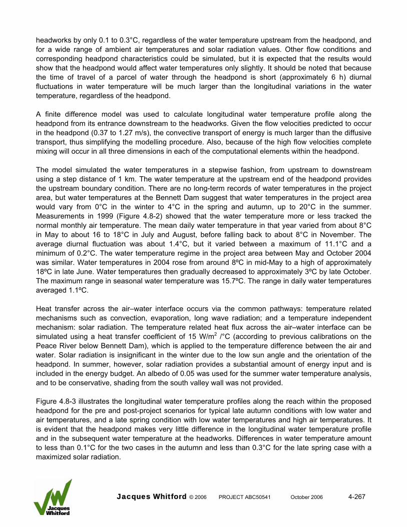
headworks by only 0.1 to 0.3°C, regardless of the water temperature upstream from the headpond, and for a wide range of ambient air temperatures and solar radiation values. Other flow conditions and corresponding headpond characteristics could be simulated, but it is expected that the results would show that the headpond would affect water temperatures only slightly. It should be noted that because the time of travel of a parcel of water through the headpond is short (approximately 6 h) diurnal fluctuations in water temperature will be much larger than the longitudinal variations in the water temperature, regardless of the headpond. A finite difference model was used to calculate longitudinal water temperature profile along the headpond from its entrance downstream to the headworks. Given the flow velocities predicted to occur in the headpond (0.37 to 1.27 m/s), the convective transport of energy is much larger than the diffusive transport, thus simplifying the modelling procedure. Also, because of the high flow velocities complete mixing will occur in all three dimensions in each of the computational elements within the headpond. The model simulated the water temperatures in a stepwise fashion, from upstream to downstream using a step distance of 1 km. The water temperature at the upstream end of the headpond provides the upstream boundary condition. There are no long-term records of water temperatures in the project area, but water temperatures at the Bennett Dam suggest that water temperatures in the project area would vary from 0°C in the winter to 4°C in the spring and autumn, up to 20°C in the summer. Measurements in 1999 (Figure 4.8-2) showed that the water temperature more or less tracked the normal monthly air temperature. The mean daily water temperature in that year varied from about 8°C in May to about 16 to 18°C in July and August, before falling back to about 8°C in November. The average diurnal fluctuation was about 1.4°C, but it varied between a maximum of 11.1°C and a minimum of 0.2°C. The water temperature regime in the project area between May and October 2004 was similar. Water temperatures in 2004 rose from around 8ºC in mid-May to a high of approximately 18ºC in late June. Water temperatures then gradually decreased to approximately 3ºC by late October. The maximum range in seasonal water temperature was 15.7ºC. The range in daily water temperatures averaged 1.1ºC. Heat transfer across the air–water interface occurs via the common pathways: temperature related mechanisms such as convection, evaporation, long wave radiation; and a temperature independent mechanism: solar radiation. The temperature related heat flux across the air–water interface can be simulated using a heat transfer coefficient of 15 W/m2 /°C (according to previous calibrations on the Peace River below Bennett Dam), which is applied to the temperature difference between the air and water. Solar radiation is insignificant in the winter due to the low sun angle and the orientation of the headpond. In summer, however, solar radiation provides a substantial amount of energy input and is included in the energy budget. An albedo of 0.05 was used for the summer water temperature analysis, and to be conservative, shading from the south valley wall was not provided. Figure 4.8-3 illustrates the longitudinal water temperature profiles along the reach within the proposed headpond for the pre and post-project scenarios for typical late autumn conditions with low water and air temperatures, and a late spring condition with low water temperatures and high air temperatures. It is evident that the headpond makes very little difference in the longitudinal water temperature profile and in the subsequent water temperature at the headworks. Differences in water temperature amount to less than 0.1°C for the two cases in the autumn and less than 0.3°C for the late spring case with a maximized solar radiation.
Jacques Whitford © 2006 PROJECT ABC50541 October 2006 4-267

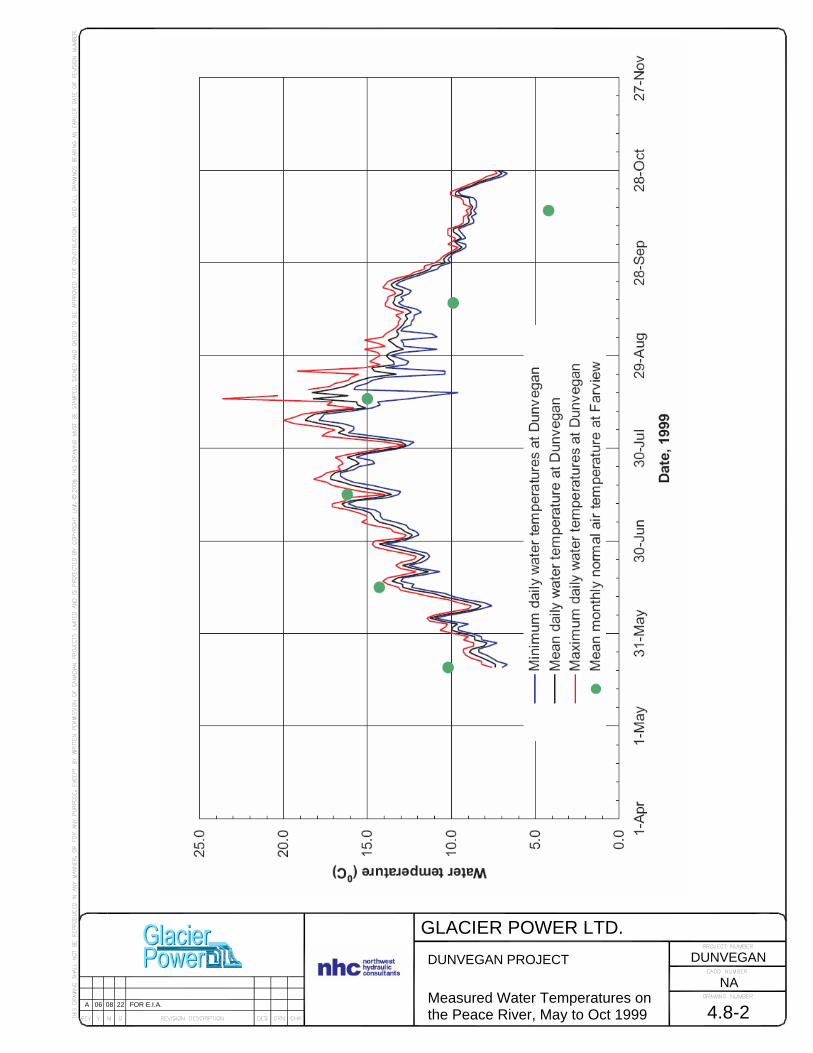
GLACIER POWER LTD.
4.8-2
DUNVEGAN PROJECT Measured Water Temperatures on the Peace River, May to Oct 1999
NA
DUNVEGAN
A 06 08 22 FOR E.I.A.

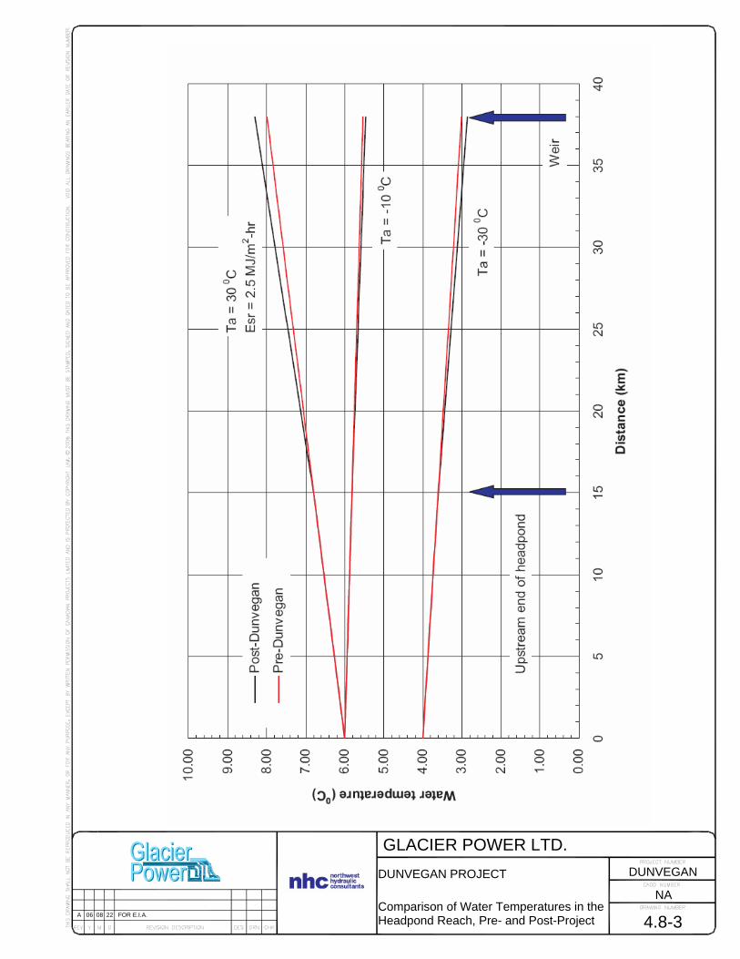
GLACIER POWER LTD.
4.8-3
DUNVEGAN PROJECT Comparison of Water Temperatures in the Headpond Reach, Pre- and Post-Project
NA
DUNVEGAN
A 06 08 22 FOR E.I.A.

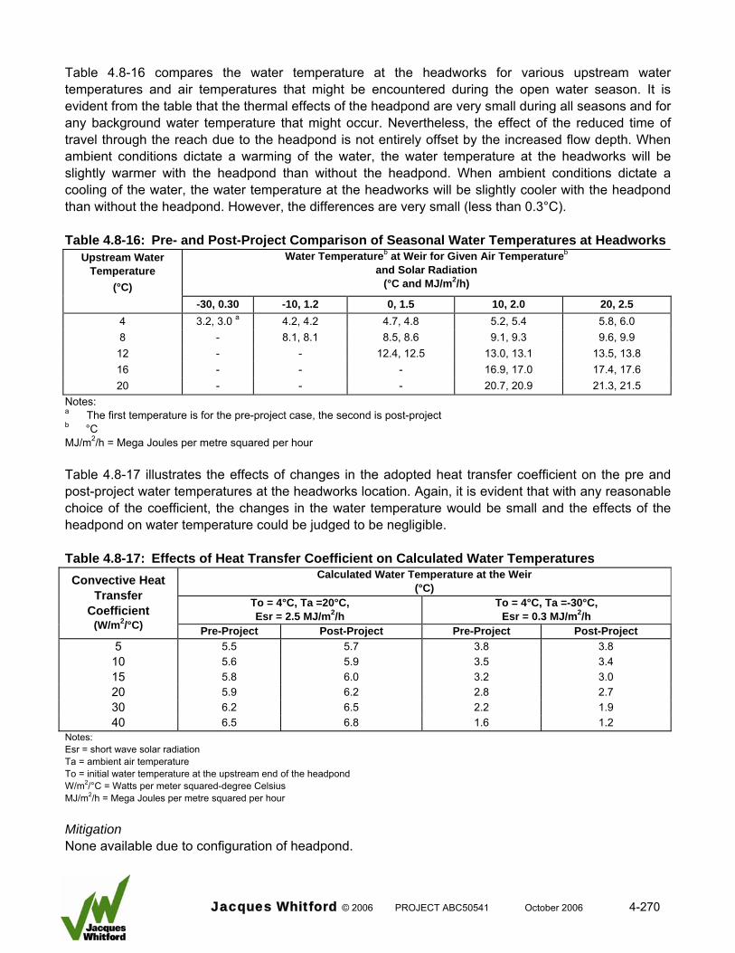
Table 4.8-16 compares the water temperature at the headworks for various upstream water temperatures and air temperatures that might be encountered during the open water season. It is evident from the table that the thermal effects of the headpond are very small during all seasons and for any background water temperature that might occur. Nevertheless, the effect of the reduced time of travel through the reach due to the headpond is not entirely offset by the increased flow depth. When ambient conditions dictate a warming of the water, the water temperature at the headworks will be slightly warmer with the headpond than without the headpond. When ambient conditions dictate a cooling of the water, the water temperature at the headworks will be slightly cooler with the headpond than without the headpond. However, the differences are very small (less than 0.3°C). Table 4.8-16: Pre- and Post-Project Comparison of Seasonal Water Temperatures at Headworks
Upstream Water Temperature
(°C)
Water Temperatureb at Weir for Given Air Temperatureb and Solar Radiation
(°C and MJ/m2/h)
-30, 0.30 -10, 1.2 0, 1.5 10, 2.0 20, 2.5 4 3.2, 3.0 a 4.2, 4.2 4.7, 4.8 5.2, 5.4 5.8, 6.0 8 - 8.1, 8.1 8.5, 8.6 9.1, 9.3 9.6, 9.9 12 - - 12.4, 12.5 13.0, 13.1 13.5, 13.8 16 - - - 16.9, 17.0 17.4, 17.6 20 - - - 20.7, 20.9 21.3, 21.5
Notes: a The first temperature is for the pre-project case, the second is post-project b °C MJ/m2/h = Mega Joules per metre squared per hour Table 4.8-17 illustrates the effects of changes in the adopted heat transfer coefficient on the pre and post-project water temperatures at the headworks location. Again, it is evident that with any reasonable choice of the coefficient, the changes in the water temperature would be small and the effects of the headpond on water temperature could be judged to be negligible. Table 4.8-17: Effects of Heat Transfer Coefficient on Calculated Water Temperatures
Calculated Water Temperature at the Weir (°C)
To = 4°C, Ta =-30°C, Esr = 0.3 MJ/m2/h
To = 4°C, Ta =20°C, Esr = 2.5 MJ/m2/h
Convective Heat Transfer
Coefficient (W/m2/°C) Pre-Project Post-Project Pre-Project Post-Project
5 5.5 5.7 3.8 3.8 10 5.6 5.9 3.5 3.4 15 5.8 6.0 3.2 3.0 20 5.9 6.2 2.8 2.7 30 6.2 6.5 2.2 1.9 40 6.5 6.8 1.6 1.2
Notes: Esr = short wave solar radiation Ta = ambient air temperature To = initial water temperature at the upstream end of the headpond W/m2/°C = Watts per meter squared-degree Celsius MJ/m2/h = Mega Joules per metre squared per hour Mitigation None available due to configuration of headpond.
Jacques Whitford © 2006 PROJECT ABC50541 October 2006 4-270
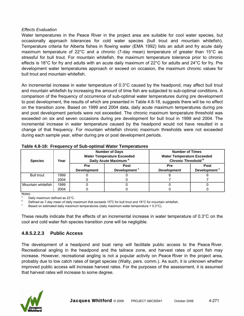
Effects Evaluation Water temperatures in the Peace River in the project area are suitable for cool water species, but occasionally approach tolerances for cold water species (bull trout and mountain whitefish). Temperature criteria for Alberta fishes in flowing water (EMA 1992) lists an adult and fry acute daily maximum temperature of 22°C and a chronic (7-day mean) temperature of greater than 15°C as stressful for bull trout. For mountain whitefish, the maximum temperature tolerance prior to chronic effects is 18°C for fry and adults with an acute daily maximum of 22°C for adults and 24°C for fry. Pre development water temperatures approach or exceed on occasion, the maximum chronic values for bull trout and mountain whitefish. An incremental increase in water temperature of 0.3°C caused by the headpond, may affect bull trout and mountain whitefish by increasing the amount of time fish are subjected to sub-optimal conditions. A comparison of the frequency of occurrence of sub-optimal water temperatures during pre development to post development, the results of which are presented in Table 4.8-18, suggests there will be no effect on the transition zone. Based on 1999 and 2004 data, daily acute maximum temperatures during pre and post development periods were not exceeded. The chronic maximum temperature threshold was exceeded on six and seven occasions during pre development for bull trout in 1999 and 2004. The incremental increase in water temperature caused by the headpond would not have resulted in a change of that frequency. For mountain whitefish chronic maximum thresholds were not exceeded during each sample year, either during pre or post development periods. Table 4.8-18: Frequency of Sub-optimal Water Temperatures
Number of Days Water Temperature Exceeded
Daily Acute Maximum a
Number of Times Water Temperature Exceeded
Chronic Threshold bSpecies Year Pre
Development Post
Development cPre
Development Post
Development c
Bull trout 1999 0 0 6 6 2004 0 0 7 7
Mountain whitefish 1999 0 0 0 0 2004 0 0 0 0
Notes: a Daily maximum defined as 22°C. b Defined as 7-day mean of daily maximum that exceeds 15oC for bull trout and 18°C for mountain whitefish. c Based on estimated daily maximum temperatures (daily maximum water temperature + 0.3°C). These results indicate that the effects of an incremental increase in water temperature of 0.3°C on the cool and cold water fish species transition zone will be negligible. 4.8.5.2.2.3 Public Access The development of a headpond and boat ramp will facilitate public access to the Peace River. Recreational angling in the headpond and the tailrace zone, and harvest rates of sport fish may increase. However, recreational angling is not a popular activity on Peace River in the project area, probably due to low catch rates of target species (Walty, pers. comm.). As such, it is unknown whether improved public access will increase harvest rates. For the purposes of the assessment, it is assumed that harvest rates will increase to some degree.
Jacques Whitford © 2006 PROJECT ABC50541 October 2006 4-271

Sport fish targeted would include walleye, goldeye, northern pike and burbot. The harvest of bull trout in the province of Alberta is currently not legal (AENV 2000b); it is expected that there will be incidental mortalities associated with the capture of this species. Large numbers of sport fish do not currently use Hines and Dunvegan Creek, and Ksituan River and it is not expected that use of these systems by sport fish would change during the life span of the development. As such, recreational angling from the access roads is not an issue. Planned habitat compensation measures (Mainstream 2006c) will increase the availability of northern pike in the headpond area and may increase the vulnerability of fish within the physical compensation works during the spawning season. Mitigation To eliminate the potential effect of over harvest, Glacier Power would be willing, after discussions with ASRD, to implement a no angling policy near the Project. Overharvest of fish by the general public can be minimized by instituting a no trespass zone on the private property adjacent to the tailrace. In addition, current provincial regulations prohibit angling within 25 yards (22.86 m) of the lower entrance of a fishway (ASRD 2006a). These mitigation measures will not prevent recreational angling by the general public in the headpond. In this case, ASRD can impose specific regulations to protect the fisheries as follows: • total or partial seasonal closures to fishing
• implementing no harvest regulations for specific target species
• changes in daily possession limits
• implementation of increased minimum size of harvested fish
• implementation of other fisheries management techniques at their discretion Effects Evaluation Based on these mitigation options, the potential effect of angling by the public will be partially mitigated. The boat ramp will facilitate access to the headpond, so there is the potential for increased pressure on the resource; however, a number of factors suggest that this will no additional effect on fish populations in the area. First, an existing boat ramp at Dunvegan Bridge currently facilitates public access; therefore, a second boat ramp in the headpond will maintain, but not increase public access to the river. Second, recreational angling is not a popular activity on Peace River in the project area, which is likely due to low catch rates of target species. Although the boat ramp may facilitate public access to the headpond, low success rates will minimize any incentive to increase recreational angling activity. Assuming that angler catch rates will remain constant for the duration of the Project, increased recreational angling attributed to the Project would not adversely affect the fish health and survival.
Jacques Whitford © 2006 PROJECT ABC50541 October 2006 4-272
4.8.5.2.2.4 Maintenance Given the longevity of the Project, maintenance of several structures will be required. Refurbishing of the bridges across Hines and Dunvegan creeks and refurbishing of the public boat ramp will produce negligible effects unless blasting and extensive earthworks are required, which is unlikely. Regular turbine maintenance will also be required. Each activity has the potential to adversely affect fish health and survival through introduction of contaminants or stranding of fish in the work area. Mitigation Standard mitigation measures will be employed during maintenance similar to those used for construction (See Section 3.10 and Section 5) Lubricant oils used for the turbine units will be environmentally friendly brands which will eliminate effects associated with minor spills. Limiting the amount and type of hazardous materials transported to the project site can minimize the potential for release of toxic materials into the aquatic environment. In the event of a spill, a response plan will be in place to allow a rapid and effective response. Effects Evaluation Mitigation measures will essentially eliminate the potential for adverse effects; therefore, there will be negligible effects on the fish community. 4.8.5.2.2.5 Headworks Operation Operation of the headworks structure likely will cause entrainment of fish, which potentially could affect fish health and survival. Entrainment occurs when a fish is accidentally drawn or intentionally enters into a water intake structure and cannot escape due to excessive water velocity (DFO 1995). Entrainment is associated with hydroelectric facilities where fish pass through turbine intakes, power canals, or spillways during their downstream migration; it also occurs at intake structures associated with irrigation, water cooling, and domestic or industrial water supplies (Stone and Webster 1995). The potential for an adverse effect of entrainment on a fish population’s health and survival is dependent primarily on three factors:
• population tendency to move downstream (movement strategy)
• portion of the population that passes through the structure
• facility operation, which can affect passage route (spillway versus turbines) Movement Strategy The tendency to move downstream, and therefore, be entrained is based primarily on fish movement strategy. In a review of fish movement behaviour in relation to passage through hydroelectric facilities, Coutant and Whitney (2000), categorized fish based on their tendency to migrate. These would include anadromous species (e.g., salmon), nonanadromous freshwater migrants, and nonmigratory residents. Smolt of anadromous salmon exhibit a behavioural motivation to move downstream in order to complete their life cycles and this drive increases their susceptibility to entrainment. Coutant and Whitney (2000) indicated that freshwater migrants demonstrate migratory tendencies similar to their anadromous counterparts although the distance traveled typically is not as great. Therefore, this group
Jacques Whitford © 2006 PROJECT ABC50541 October 2006 4-273
also would be highly susceptible to entrainment. An example of a nonanadromous freshwater migrant species in the Peace River is the goldeye. The majority of adult goldeye in the Peace River population undertake extensive, unidirectional migrations to and from important habitats (Mainstream 2006c). In contrast, nonmigratory resident fish, which by definition lack true migratory behaviour, are adapted to resist the tendency to move downstream that would displace them from their normal habitats. The majority of species populations in the project area are resident (Mainstream 2006a). Entrainment of most resident fish populations is dictated primarily by their habitat preferences and local movements during the annual life cycle. As such, the probability of entrainment of resident fish is highly site specific, depending on the species, life stage, and distribution of habitats. For truly resident fish that do not move, entrainment is related to the degree to which each species or life stage uses the area in close proximity to the entrainment zone. For this category of resident fish entrainment can be viewed as accidental, with fish unable to break away from approach velocities at the intake structure. Susceptibility in this case is due to feeding activities, habitat preferences, or the inability to move away from the entrainment zone (e.g., cold torpor in winter). As for migratory species, susceptibility of resident fish in close proximity to a facility can be based on motivation to move. This motivation is regulated by a complex interplay between environmental cues and the resulting response by fish that varies with species, size, age, and sex (Northcote 1998). Superimposed on the effects of these environmental cues are genetic controls at the species and stock level that ultimately guide the movement response (Leggett 1977). Northcote (1997) indicated that resident fish may move only short distances, but these movements may be essential to the fitness of the population. Movements are required by fish to complete their life cycles and result from the separation in space and time of optimal habitats needed to maximize production. Furthermore, use of habitats and movements between those habitats are dependent on the life stage and the type of habitat required. In the north temperate region, which includes the project area, movements involve cyclic, seasonal alternations between three primary habitat types that include spawning, rearing and feeding, and wintering habitats. Typically, young fish emerge from the spawning habitat and either passively or actively move to their first feeding habitat. This movement may be only a few metres or may be several kilometres. Usually, the juveniles later undertake movements from their feeding habitat to wintering habitat in order to survive unfavourable conditions. This cyclic movement between feeding and wintering habitats may occur only once or it could be repeated over several years until the juvenile approaches maturity. At this point, the mature individual (adult) will initiate movement to spawning habitat. Similar to younger fish, this movement may only be a few metres or it may be several kilometres; it can occur once or on several occasions. The extent, frequency, direction, and cyclic nature of these movements will dictate how vulnerable a fish is to entrainment. The LSA fish community consists of both migratory and nonmigratory (resident) fish populations (Table 4.8-19). In the LSA, only goldeye and possibly flathead chub are considered migratory. The timing and direction of expected fish movements are discussed in detail in Mainstream (2006a, c) and Section 4.8.2.5, and are depicted in Table 4.8-2. In general, entrainment due to downstream movement in the project area is most likely to occur from August to November for most fish species. The only exception is burbot, which moves downstream in December and January.
Jacques Whitford © 2006 PROJECT ABC50541 October 2006 4-274
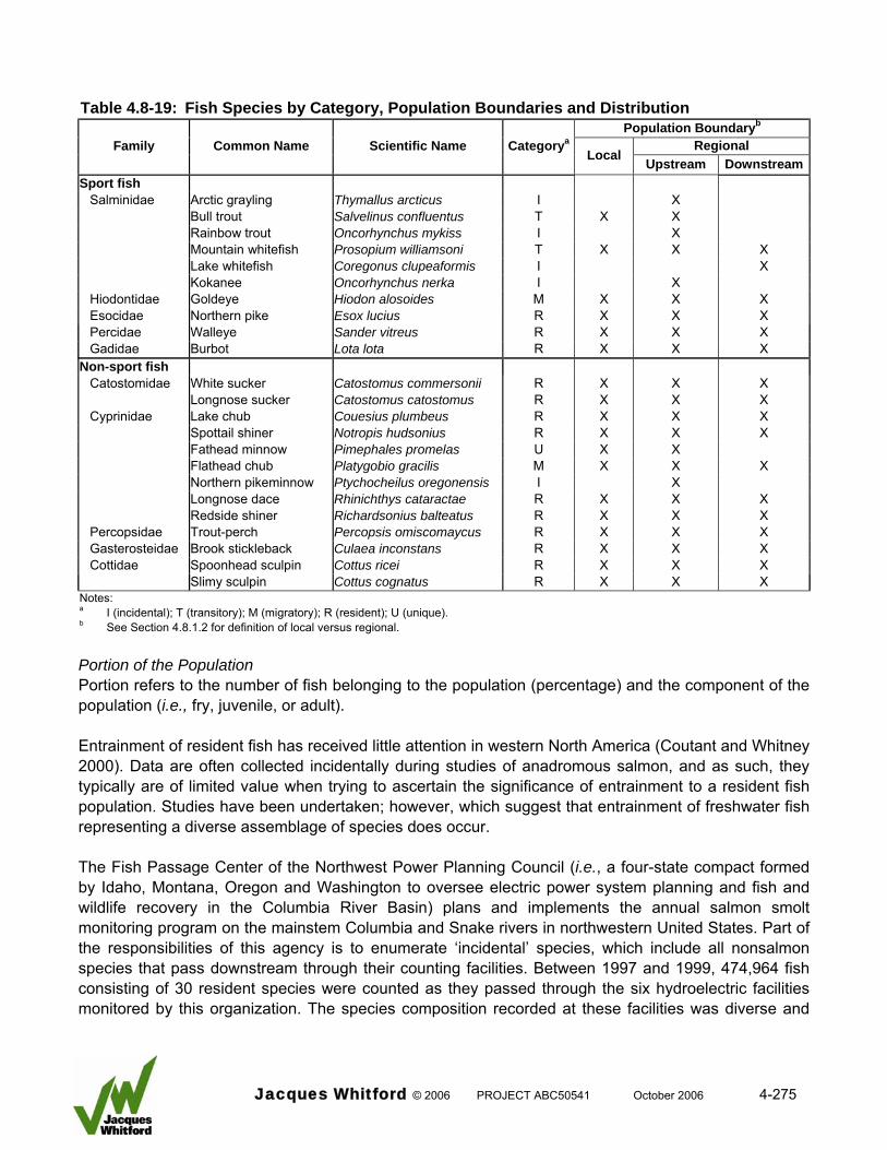
Table 4.8-19: Fish Species by Category, Population Boundaries and Distribution
Population Boundaryb
Regional Family Common Name Scientific Name Categorya
Local Upstream DownstreamSport fish
Salminidae Arctic grayling Thymallus arcticus I X Bull trout Salvelinus confluentus T X X Rainbow trout Oncorhynchus mykiss I X Mountain whitefish Prosopium williamsoni T X X X Lake whitefish Coregonus clupeaformis I X Kokanee Oncorhynchus nerka I X Hiodontidae Goldeye Hiodon alosoides M X X X Esocidae Northern pike Esox lucius R X X X Percidae Walleye Sander vitreus R X X X Gadidae Burbot Lota lota R X X X
Non-sport fish Catostomidae White sucker Catostomus commersonii R X X X Longnose sucker Catostomus catostomus R X X X Cyprinidae Lake chub Couesius plumbeus R X X X Spottail shiner Notropis hudsonius R X X X Fathead minnow Pimephales promelas U X X Flathead chub Platygobio gracilis M X X X Northern pikeminnow Ptychocheilus oregonensis I X Longnose dace Rhinichthys cataractae R X X X Redside shiner Richardsonius balteatus R X X X Percopsidae Trout-perch Percopsis omiscomaycus R X X X Gasterosteidae Brook stickleback Culaea inconstans R X X X Cottidae Spoonhead sculpin Cottus ricei R X X X Slimy sculpin Cottus cognatus R X X X
Notes: a I (incidental); T (transitory); M (migratory); R (resident); U (unique). b See Section 4.8.1.2 for definition of local versus regional.
Portion of the Population Portion refers to the number of fish belonging to the population (percentage) and the component of the population (i.e., fry, juvenile, or adult). Entrainment of resident fish has received little attention in western North America (Coutant and Whitney 2000). Data are often collected incidentally during studies of anadromous salmon, and as such, they typically are of limited value when trying to ascertain the significance of entrainment to a resident fish population. Studies have been undertaken; however, which suggest that entrainment of freshwater fish representing a diverse assemblage of species does occur. The Fish Passage Center of the Northwest Power Planning Council (i.e., a four-state compact formed by Idaho, Montana, Oregon and Washington to oversee electric power system planning and fish and wildlife recovery in the Columbia River Basin) plans and implements the annual salmon smolt monitoring program on the mainstem Columbia and Snake rivers in northwestern United States. Part of the responsibilities of this agency is to enumerate ‘incidental’ species, which include all nonsalmon species that pass downstream through their counting facilities. Between 1997 and 1999, 474,964 fish consisting of 30 resident species were counted as they passed through the six hydroelectric facilities monitored by this organization. The species composition recorded at these facilities was diverse and
Jacques Whitford © 2006 PROJECT ABC50541 October 2006 4-275
included small-sized cyprinids, as well as larger-sized non-sport fish and sport fish. These data indicate that on the Columbia system in the United States, resident fish pass downstream through hydroelectric facilities, which is evidence that they are susceptible to entrainment. A database developed on behalf of the Electric Power Institute has documented resident fish entrainment at more than 100 hydroelectric facilities in central and eastern United States (Winchell et al. 2000). Over 24 families of fish are represented in this database, the majority of which would be considered resident (greater than 80 percent of the families). Even within a relatively short section of river, fish entrainment can occur. Navarro et al. (1996) monitored entrainment of fish through four hydroelectric facilities on a 62 km section of the Thunder Bay River in northeastern Michigan. Between 1991 and 1993, approximately 80,000 fish representing 41 species were collected from these facilities. The majority were resident (38 species) and included a diverse assemblage of families such as cyprinids, catostomids, centrids, and salmonids. Based on this information, entrainment of resident fish can be considered a common occurrence and there are indications that large numbers of fish can be entrained. But, these data do not indicate what component of a resident population is most likely to be entrained. In general, larger fish are less susceptible to entrainment than smaller fish because they are stronger swimmers that can resist entrainment velocities or they do not have the same propensity to undertake downstream movements. Several studies have documented that small fish often comprise the bulk of fish entrained at hydroelectric facilities (Taft et al. 1992; Stone and Webster 1995; Winchell et al. 2000). These include small-sized species (e.g., cyprinids) and younger life stages of larger-sized fish species. Navarro et al. (1996) documented that 63 percent of the fish passing through several hydroelectric facilities in Michigan were less than 100 mm long. An investigation of fish entrainment at an irrigation intake structure on the Bow River in Alberta by (RL&L 1999) established that small fish (less than 200 mm) dominated the sample (82 percent) and there were seasonal patterns of entrainment. Not only was the sample dominated by cyprinids, young-of-the-year, and juveniles, but entrainment occurred primarily in late summer and fall. This information supports the position that smaller fish are most likely to be entrained due to downstream movements related to dispersal. As such, this component of a resident population is most likely to be entrained. Unlike migratory species, it is unlikely that substantial portions of resident fish populations in the project area undertake downstream movements. Movement studies demonstrated that large portions of monitored samples did not undertake unidirectional movements (Section 4.8.2.5). In addition, important habitats are present upstream and downstream from the project area suggesting that there is not an ecological imperative for the entire population to move past the proposed facility (Section 4.8.2.7).
Jacques Whitford © 2006 PROJECT ABC50541 October 2006 4-276
Studies have established that for large-sized fish species, younger fish comprised the bulk of the entrained sample. Loss of mature fish, which contribute to the productive capacity of a population, is arguably more important than loss of young, immature fish. As such, the relative portion of these groups that are entrained by the Project would influence the effect on the population. Facility Operation The number of fish that are entrained is dependent on facility operation. Downstream moving fish have a high tendency to follow bulk water flow (largest portion of available flow), which provides a signal that directs fish to the most expedient passage route (Coutant and Whiteney 2000). Headworks operation of the Project will be continuous because there is no storage capacity. Primary downstream passage routes include the powerhouse turbines, the spillway, and the downstream fish passage system. Bulk flow will occur through the turbines at all times during normal river discharge (greater than 84 percent of available flow). The spillway and fish passage system will operate depending on the time of year and mitigation strategy to be employed. The effects evaluation of facility operation will examine spillway and turbine effects in relation to the fish passage system that would be used as mitigation. Spillway The spillway is a gated fixed crest Ogee shaped design used to provide flood discharge capacity for flows in excess of approximately 2,150 m3/s. Flows less than this amount would normally be passed through the powerhouse units and the fish bypass sluices, which would be used to regulate upstream water levels. The downstream lip of the spillway is designed to direct the discharge horizontally to prevent spill flow from plunging to depth. Energy dissipaters will be at the base of the spillway in the tailrace zone. Energy dissipaters are the Standard Basin III type (USBR designation) for small spillways. Each of the seven spillway chutes will contain five energy dissipaters, two in the front and three in the rear of the tailrace. Spillway operation in terms of frequency and duration will depend on river flow versus operational requirements. In general, spillway flow will not occur for 90 percent of all expected flows under normal operating conditions (equal to or less than 2,150 m3/s) Table 4.8-20 provides a summary of percent average bi-weekly apportionment of Peace River flow through the major headworks structures. Structures include turbines, spillway, downstream sluiceways, and upstream fishway or auxiliary flow systems. Flows through the boat lock are considered negligible, and therefore, are not included in the summary.
Jacques Whitford © 2006 PROJECT ABC50541 October 2006 4-277
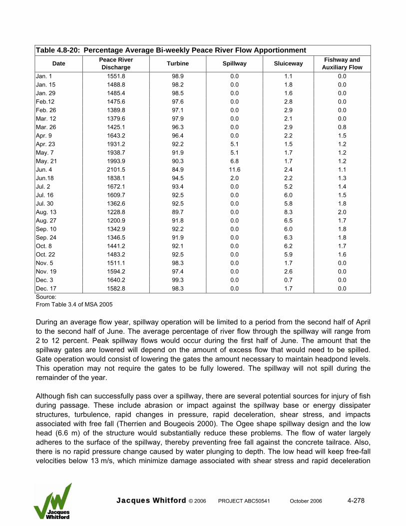
Table 4.8-20: Percentage Average Bi-weekly Peace River Flow Apportionment
Date Peace River Discharge Turbine Spillway Sluiceway Fishway and
Auxiliary Flow Jan. 1 1551.8 98.9 0.0 1.1 0.0 Jan. 15 1488.8 98.2 0.0 1.8 0.0 Jan. 29 1485.4 98.5 0.0 1.6 0.0 Feb.12 1475.6 97.6 0.0 2.8 0.0 Feb. 26 1389.8 97.1 0.0 2.9 0.0 Mar. 12 1379.6 97.9 0.0 2.1 0.0 Mar. 26 1425.1 96.3 0.0 2.9 0.8 Apr. 9 1643.2 96.4 0.0 2.2 1.5 Apr. 23 1931.2 92.2 5.1 1.5 1.2 May. 7 1938.7 91.9 5.1 1.7 1.2 May. 21 1993.9 90.3 6.8 1.7 1.2 Jun. 4 2101.5 84.9 11.6 2.4 1.1 Jun.18 1838.1 94.5 2.0 2.2 1.3 Jul. 2 1672.1 93.4 0.0 5.2 1.4 Jul. 16 1609.7 92.5 0.0 6.0 1.5 Jul. 30 1362.6 92.5 0.0 5.8 1.8 Aug. 13 1228.8 89.7 0.0 8.3 2.0 Aug. 27 1200.9 91.8 0.0 6.5 1.7 Sep. 10 1342.9 92.2 0.0 6.0 1.8 Sep. 24 1346.5 91.9 0.0 6.3 1.8 Oct. 8 1441.2 92.1 0.0 6.2 1.7 Oct. 22 1483.2 92.5 0.0 5.9 1.6 Nov. 5 1511.1 98.3 0.0 1.7 0.0 Nov. 19 1594.2 97.4 0.0 2.6 0.0 Dec. 3 1640.2 99.3 0.0 0.7 0.0 Dec. 17 1582.8 98.3 0.0 1.7 0.0 Source: From Table 3.4 of MSA 2005 During an average flow year, spillway operation will be limited to a period from the second half of April to the second half of June. The average percentage of river flow through the spillway will range from 2 to 12 percent. Peak spillway flows would occur during the first half of June. The amount that the spillway gates are lowered will depend on the amount of excess flow that would need to be spilled. Gate operation would consist of lowering the gates the amount necessary to maintain headpond levels. This operation may not require the gates to be fully lowered. The spillway will not spill during the remainder of the year. Although fish can successfully pass over a spillway, there are several potential sources for injury of fish during passage. These include abrasion or impact against the spillway base or energy dissipater structures, turbulence, rapid changes in pressure, rapid deceleration, shear stress, and impacts associated with free fall (Therrien and Bougeois 2000). The Ogee shape spillway design and the low head (6.6 m) of the structure would substantially reduce these problems. The flow of water largely adheres to the surface of the spillway, thereby preventing free fall against the concrete tailrace. Also, there is no rapid pressure change caused by water plunging to depth. The low head will keep free-fall velocities below 13 m/s, which minimize damage associated with shear stress and rapid deceleration
Jacques Whitford © 2006 PROJECT ABC50541 October 2006 4-278
(Bell and DeLacy 1972). In addition, water depth in the tailrace zone would exceed 4.9 m during a spill event, which also would reduce the probability of impact against the floor of the tailrace. The energy dissipaters at the base of the spillway have the potential to injure fish. Due to the lack of data for the species of interest (Therrien and Bougeois 2000) or the Basin III type energy dissipater, it is not possible to estimate fish injury rate for the Project. Spillways with energy dissipaters are known to cause lower survival of salmon smolts compared to spillways that do not have energy dissipaters, but survival rates under both scenarios is generally high (Muir et al. 2001). After a review of 3 facilities on the Snake River Muir et al. (2001) found that estimated relative survival ranged from 98.4 percent to 100.0 percent through spill bays without flow deflectors compared to 92.7 percent to 100.0 percent for spill bays with flow deflectors. Based on this information it is likely that a small percentage of fish that pass over the project spillway will suffer injury. The probability of fish passing over the spillway, and subsequently being injured, is primarily dependent on two factors. These are the percentage of available flow that is spilled and the timing of the spill relative to downstream fish movement. The greatest potential for an adverse effect would occur if a large percentage available flow passes over the spillway during a period when a large percentage of a fish population moves downstream past the headworks. Fish species populations in the project area do not undertake strong, unidirectional downstream movements during the period April to June; the majority is expected to move upstream during this period including goldeye that are migratory (see Section 4.8.2.5). However, a portion of some populations may have a tendency to move downstream. These include longnose sucker, walleye, and mountain whitefish. The first two species populations are resident and it is expected that only fish in close proximity to the headworks would potentially be entrained through the spillway. Mountain whitefish found in the project area are transients that disperse from upstream areas. This dispersal activity likely is continuous; therefore, this species has the highest probability of being entrained over the spillway. Mitigation Mitigation measures include use of downstream sluiceways as an alternate downstream passage route. The percentage of available flow through this alternate route during spillway operation will be 1.5 percent to 2.4 percent (Table 4.8-20). The fishways also will provide an alternate downstream passage route, but flows will not exceed 2 m3/s. Assuming that downstream passage route used by fish is directly proportional to water volume, the effectiveness of mitigation (i.e., directing fish away from spillways during downstream passage) will depend on the relative flow over the spillway versus through the alternate downstream passage routes. Sluiceways and fishways will provide partial mitigation as alternate passage routes for the spillway. Turbines also will provide a downstream passage route for smaller-sized fish (see Section 4.8.5.2.3). Given the assumed high survival rate of small fish during spillway passage relative to turbine passage, turbines are not considered mitigation. A detailed discussion of turbine passage and fish survival is provided in the evaluation of turbine effects.
Jacques Whitford © 2006 PROJECT ABC50541 October 2006 4-279
To minimize injury the spill pool below the spillway should have a minimum depth of 0.9 m, be equal to a quarter of the differential head, and the volume of the pool must be about 10 m3 for every cubic meter of flow to allow for an adequate energy dissipation (Odeh and Orvis 1998). The project design meets these criteria (Slopek, pers. comm.). Effects Evaluation The potential adverse effect on fish health and survival caused by spillway operation is expected to be negligible for most fish species populations. No migratory species and few resident species populations will require downstream passage during the spillway operation period (April to June). Fish of two resident species populations (longnose sucker and walleye) may move downstream during this period, but it is expected that only fish in close proximity to the structure will be entrained because movement data indicate that these fish move only short distances and only a portion of the populations move downstream. Juvenile mountain whitefish have the potential to be affected by spillway operation because this transient species likely disperses downstream past the facility during the period April to June. Based on the size and age characteristics of mountain whitefish that occur in the LSA during the period April to June, the majority (greater than 60 percent) would consist of young-of-the year and small juveniles less than 150 mm in length (Mainstream 2006a). In addition, mountain whitefish in the project area are not part of a viable, self-sustaining population. The configuration of the spillway suggests that some fish that pass over the spillway will be injured, but data from other hydroelectric facilities suggests that survival rates will be very high despite the presence of energy dissipaters in the tailrace (greater than 90 percent). Given the spillway operation and design, and the downstream movement strategies of fish species populations in the project area some fish of three resident species populations will be entrained during spillway operation. Survival rates of fish that are entrained by the spillway are expected to be high. Although there will be some adverse effects on fish health and survival caused by spillway operation, these are expected to be small. Turbines The headworks powerhouse will consist of 30 turbine units arranged side by side extending from the south bank of the main channel and 10 turbine units arranged side by side extending from the north bank of the main channel for a total powerhouse length of 286 m. Each unit, which is 6.2 m wide, would be comprised of a 2500 kW (2.5 MW) propeller type turbine. The turbine would have four fixed-pitch blades and a runner diameter of 2.6 m, and would rotate at about 170 rpm. The operable flow for each unit is between 42.5 m3/s and 46.3 m3/s. The turbine will typically operate at full capacity at a flow of 45 m3/s. The turbine units selected are based on a modular concept based on the idea that if low river flow occurs, instead of throttling down all turbines, some turbines will be shut down entirely. This will allow the remaining turbines to operate at their full capacity and peak efficiency. Total powerhouse turbine flow is 1800 m3/s. Table 4.8-20 summarizes the percent available flow used by the turbines on a bi-weekly basis during an average flow year. Turbine flow will account for 84.9 percent (second half of June) to 99.3 percent (first half of December) of total available flow.
Jacques Whitford © 2006 PROJECT ABC50541 October 2006 4-280
Fish entrained through turbines can sustain injuries (Therrien and Bougeois 2000). However, the injury rate and subsequent survival rate would depend on two primary factors: the size of fish and the characteristics of the turbine. Fish size is an important factor affecting the injury of fish passing through turbines (Cada 1990; Taft et al. 1993; Alden Research 2001). In general, smaller fish suffer lower injury rates because they pass through the available gaps and openings in the turbine system more easily than larger fish. A study conducted by Turnpenny (1998) that simulated blade velocities of 5 to 7 m/s determined that fish less than 20 g (less than 120 mm long) were generally swept aside by the water moving around the blade; however, strikes to smaller fish still occurred 14 percent of the time. Fish up to 200 g were shown to have a 75 percent chance of being struck, while heavier fish had a 100 percent chance. The mean blade velocity of the project turbines will be approximately 12 m/s; therefore, the probability of strikes likely will be higher for fish passing through the powerhouse. Turbine characteristics can affect injury rates by influencing the rate of physical strikes and by causing pressure change and shear stress. The probability of fish experiencing a physical strike from a turbine blade was calculated by Von Raben (1957) to be a function of fish length, flow, and the number of runner blades, blade angle, and revolutions/minute. In general, the higher the flow rate, and number of blades and revolutions, the greater the strike rate. Rapid pressure change adjacent to the turbine blade may cause internal injury to fish in the absence of a physical strike (Cada 1990). Cavitation can be a primary cause of pressure-induced injury (Eicher 1988). Cavitation most often occurs at high loads, when pressure drops in the turbine are greatest; however, it may also occur when the turbine is not operating at peak efficiency. It is generally believed that maximum survival of fish coincides with greatest turbine efficiency (Stone and Webster 1992). Shearing forces cause injury when two or more high-velocity flows are incidental with each other, which typically occurs at the leading edges of runner blades (Collins 1984). Although water shear is thought to be important, some studies have found insignificant injuries to early life stages and small fish (Cada 1990), whereas controlled studies designed to simulate effects of shear stress recorded a 12 percent injury rate following exposure to high levels of shear stress. Mechanical related injury (physical strikes) rather than pressure change and shear stress, has been reported as the dominant cause of fish mortality at low head (less than 30 m) projects (Franke et al. 1997). The predominant cause of injury is blade-strike (Turnpenny 1998) that would affect larger-sized fish, which has been shown by several studies (see summary by Alden Research 2001). Fish surviving turbine passage may suffer increased mortality rates through increased risk of predation caused by stress and nonlethal injuries. Predation by fish (Friesen and Ward 1999) and birds (Collis et al. 2002) can also occur. Mitigation Glacier Power has chosen a relatively slow rotating propeller type turbine design that is considered the best technology available today for this low-head application, while at the same time minimizing fish mortality.
Jacques Whitford © 2006 PROJECT ABC50541 October 2006 4-281
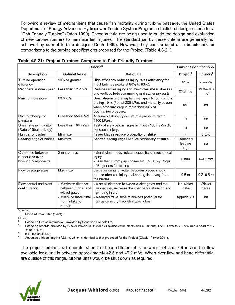
Following a review of mechanisms that cause fish mortality during turbine passage, the United States Department of Energy Advanced Hydropower Turbine System Program established design criteria for a “Fish-Friendly Turbine” (Odeh 1999). These criteria are being used to guide the design and evaluation of new turbine runners to minimize fish injuries. The standard set by these criteria are generally not achieved by current turbine designs (Odeh 1999). However, they can be used as a benchmark for comparisons to the turbine specifications proposed for the Project (Table 4.8-21).
Table 4.8-21: Project Turbines Compared to Fish-Friendly Turbines Criteriaa Turbine Specifications
Description Optimal Value Rationale Projectb Industryc
Turbine operating efficiency
90% or greater High efficiency reduces injury rates (efficiency for most turbines peaks at 90% to 93%). 91% 78–92%
Peripheral runner speed Less than 12.2 m/s Reduces strike injury and minimizes shear stresses and vortices between moving and stationary parts. 23.3 m/s 19.0–40.8
m/se
Minimum pressure 68.8 kPa Downstream migrating fish are typically found within the top 10 m (i.e., at 206 kPa), and mortality occurs when pressure drop is more than 30% of acclimation pressure.
nad na
Rate of change of pressure
Less than 550 kPa/s Assumes fish injury occurs at a pressure rate of 1100 kPa/s. na na
Shear stress indicator (Rate of Strain, du/dy)
Less than 180 m/s/m Tests of alewives, a fragile fish, with 180 m/s/m did not cause injury. na na
Number of blades Minimize Fewer blades reduce probability of strike. 4 3 to 6 Leading edge of blades Minimize Shorter leading edges reduce probability of strike. Rounded
leading edge
na
Clearance between runner and fixed housing components
2 mm or less - Small clearances reduce possibility of mechanical injury - Less than 3 mm gap chosen by U.S. Army Corps of Engineers for testing
6 mm 4–10 mm
Flow passage sizes Maximize Large amounts of water between blades should reduce abrasion injury by keeping fish away from the blades.
0.5 m 0.2–0.6 m
Flow control and plant configuration
- Maximize distance between runner and wicket gates.
- Minimize travel time from intake to runner.
- A small distance between wicket gates and the runner may increase the chance for abrasion and grinding injury.
- Reduced travel time minimizes potential for abrasion injury through intake tubes.
No wicket gates
Approx. 2 s
Wicket gates
na
Source: Modified from Odeh (1999). Notes: b Based on turbine information provided by Canadian Projects Ltd. c Based on records provided by Glacier Power (2001) for 174 hydroelectric plants with a unit output of 0.9 MW to 2.1 MW and a head of 1.7
m to 10.8 m. d na = not available. e Assumes a blade length of 2.6 m, which is identical to that proposed for the Project (Glacier Power 2001).
The project turbines will operate when the head differential is between 5.4 and 7.6 m and the flow available for a unit is between approximately 42.5 and 46.2 m3/s. When river flow and head differential are outside of this range, turbine units would be shut down as required.
Jacques Whitford © 2006 PROJECT ABC50541 October 2006 4-282
The peripheral runner speed of approximately 23.3 m/s of the proposed turbine is 94 percent higher than optimum, which indicates that fish could sustain injuries from physical strikes. However, this value is at the lower range of turbine runner speeds presently used by similar hydroelectric projects. Runner blade design features of the proposed turbine that would reduce the probability of fish injury are – use of 4 rather than 6 blades, rounded leading edge of the blade, and the 0.5 m space between the blades that provides a passage route for fish. The clearance between the runner and the fixed housing components proposed for the Project (6 mm) is greater than the 2 mm criteria in Table 4.8-23 and the 3 mm criteria used by the U.S. Army Corps of Engineers (Odeh 1999). This may increase the possibility of mechanical injury. The absence of wicket gates to control water flow will greatly reduce the potential for fish injury because the probability of a physical strike against this flow control device is eliminated. This positive effect will be partially offset by the presence of support vanes that are required to maintain the turbine unit within the draft tube. Glacier Power has committed to a comprehensive mitigation strategy to protect fish populations from the adverse effects of entrainment (NHC 2006b, see also Section 3.0). This includes the provision of a downstream fish passage system consisting of eight fish exclusion racks and ten fish passage sluiceways. These are described in Section 4.8.5.2.3. Placement of the trash racks in the low velocity zone in front of the turbines will eliminate the potential problem of fish impingement against the trash racks caused by excessive velocities (NHC 2006b). The fish exclusion trash racks will operate during the downstream movement period from August 1 to November 15 or 3.5 months of the 8 month open water period. Alternate passage routes will be available to fish. Flows through the downstream sluiceways will occur year round. The average percentage of Peace River flow through the sluiceways will range from 0.7 percent to 8.3 percent. The flow apportionment to the downstream sluiceways will be highest from the end of June to the beginning of November (greater than 5 percent). Fishways and the auxiliary flow systems will be operational from end of March to the beginning of November; the percentage of Peace River flow will range from 0.8 percent to 2.0 percent. During an average flow year, spillway operation will occur from the second half of April to the second half of June. The average percentage of river flow through the spillway will range from 2 to 12 percent. Effects Evaluation The effects evaluation of turbine entrainment on fish health and survival is based on the assumption that the fish passage mitigation strategy will achieve its goal of preventing all adult fish of large-sized fish species populations from passing downstream through the turbines while the exclusion trash racks are in place and fish will not be impinged against the trash racks. Flows through the turbines account for at least 84 percent of the total Peace River flow, and would account for greater than 92 percent of available flows during 20 of the 26 bi-weekly periods, or 76 percent of the time. Assuming that preferred downstream passage route used by fish is directly proportional to water volume, the powerhouse turbines have the highest probability of passing fish.
Jacques Whitford © 2006 PROJECT ABC50541 October 2006 4-283
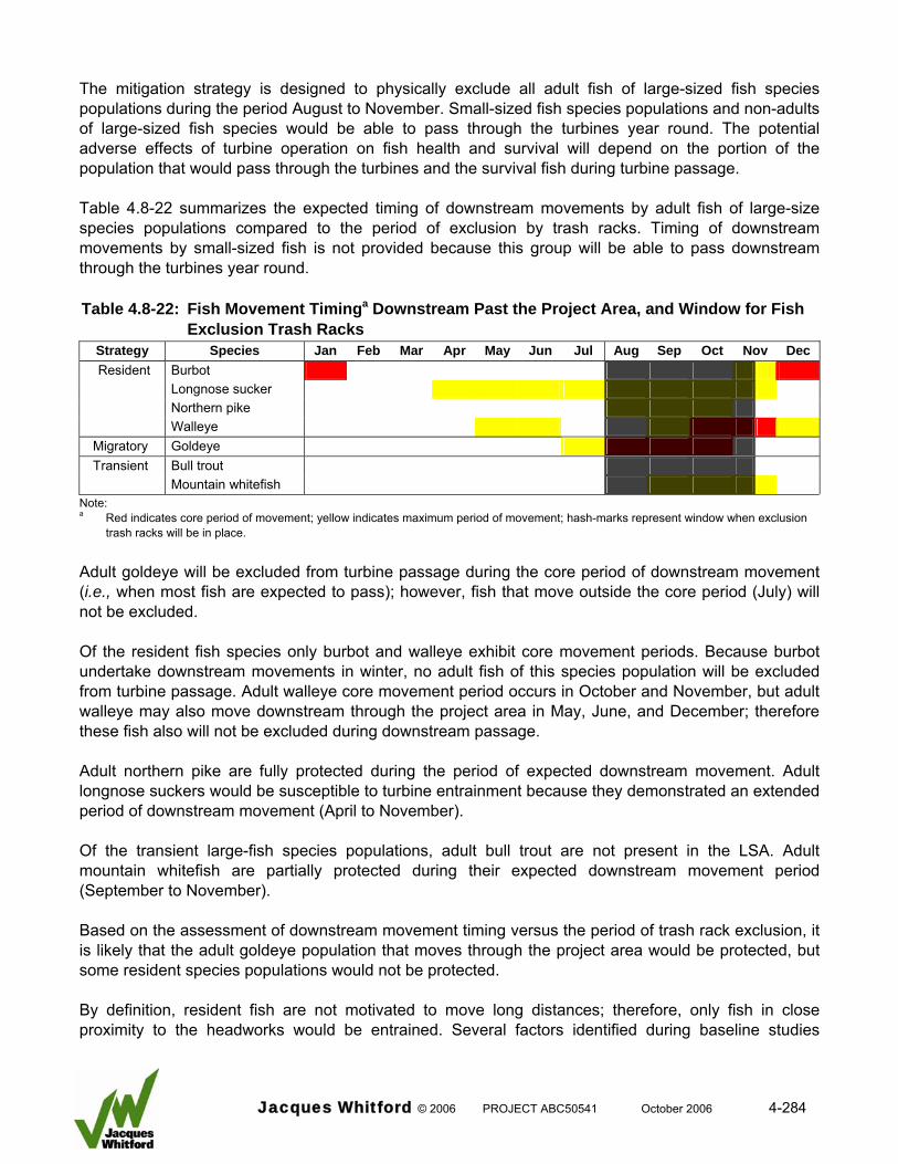
The mitigation strategy is designed to physically exclude all adult fish of large-sized fish species populations during the period August to November. Small-sized fish species populations and non-adults of large-sized fish species would be able to pass through the turbines year round. The potential adverse effects of turbine operation on fish health and survival will depend on the portion of the population that would pass through the turbines and the survival fish during turbine passage. Table 4.8-22 summarizes the expected timing of downstream movements by adult fish of large-size species populations compared to the period of exclusion by trash racks. Timing of downstream movements by small-sized fish is not provided because this group will be able to pass downstream through the turbines year round. Table 4.8-22: Fish Movement Timinga Downstream Past the Project Area, and Window for Fish
Exclusion Trash Racks Strategy Species Jan Feb Mar Apr May Jun Jul Aug Sep Oct Nov Dec Resident Burbot
Longnose sucker Northern pike Walleye
Migratory Goldeye Transient Bull trout
Mountain whitefish Note: a Red indicates core period of movement; yellow indicates maximum period of movement; hash-marks represent window when exclusion
trash racks will be in place.
Adult goldeye will be excluded from turbine passage during the core period of downstream movement (i.e., when most fish are expected to pass); however, fish that move outside the core period (July) will not be excluded. Of the resident fish species only burbot and walleye exhibit core movement periods. Because burbot undertake downstream movements in winter, no adult fish of this species population will be excluded from turbine passage. Adult walleye core movement period occurs in October and November, but adult walleye may also move downstream through the project area in May, June, and December; therefore these fish also will not be excluded during downstream passage. Adult northern pike are fully protected during the period of expected downstream movement. Adult longnose suckers would be susceptible to turbine entrainment because they demonstrated an extended period of downstream movement (April to November). Of the transient large-fish species populations, adult bull trout are not present in the LSA. Adult mountain whitefish are partially protected during their expected downstream movement period (September to November). Based on the assessment of downstream movement timing versus the period of trash rack exclusion, it is likely that the adult goldeye population that moves through the project area would be protected, but some resident species populations would not be protected. By definition, resident fish are not motivated to move long distances; therefore, only fish in close proximity to the headworks would be entrained. Several factors identified during baseline studies
Jacques Whitford © 2006 PROJECT ABC50541 October 2006 4-284
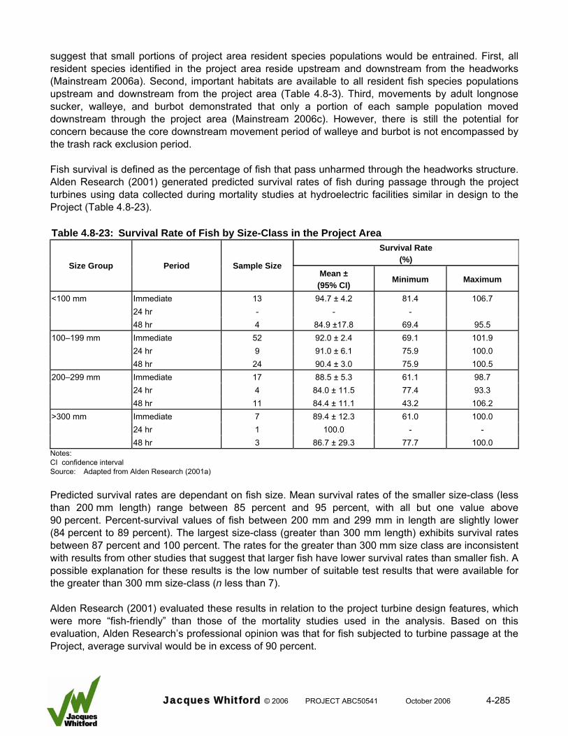
suggest that small portions of project area resident species populations would be entrained. First, all resident species identified in the project area reside upstream and downstream from the headworks (Mainstream 2006a). Second, important habitats are available to all resident fish species populations upstream and downstream from the project area (Table 4.8-3). Third, movements by adult longnose sucker, walleye, and burbot demonstrated that only a portion of each sample population moved downstream through the project area (Mainstream 2006c). However, there is still the potential for concern because the core downstream movement period of walleye and burbot is not encompassed by the trash rack exclusion period. Fish survival is defined as the percentage of fish that pass unharmed through the headworks structure. Alden Research (2001) generated predicted survival rates of fish during passage through the project turbines using data collected during mortality studies at hydroelectric facilities similar in design to the Project (Table 4.8-23). Table 4.8-23: Survival Rate of Fish by Size-Class in the Project Area
Survival Rate (%)
Size Group Period Sample Size Mean ±
(95% CI) Minimum Maximum
<100 mm Immediate 13 94.7 ± 4.2 81.4 106.7 24 hr - - - 48 hr 4 84.9 ±17.8 69.4 95.5 100–199 mm Immediate 52 92.0 ± 2.4 69.1 101.9 24 hr 9 91.0 ± 6.1 75.9 100.0 48 hr 24 90.4 ± 3.0 75.9 100.5 200–299 mm Immediate 17 88.5 ± 5.3 61.1 98.7 24 hr 4 84.0 ± 11.5 77.4 93.3 48 hr 11 84.4 ± 11.1 43.2 106.2 >300 mm Immediate 7 89.4 ± 12.3 61.0 100.0 24 hr 1 100.0 - - 48 hr 3 86.7 ± 29.3 77.7 100.0 Notes: CI confidence interval Source: Adapted from Alden Research (2001a) Predicted survival rates are dependant on fish size. Mean survival rates of the smaller size-class (less than 200 mm length) range between 85 percent and 95 percent, with all but one value above 90 percent. Percent-survival values of fish between 200 mm and 299 mm in length are slightly lower (84 percent to 89 percent). The largest size-class (greater than 300 mm length) exhibits survival rates between 87 percent and 100 percent. The rates for the greater than 300 mm size class are inconsistent with results from other studies that suggest that larger fish have lower survival rates than smaller fish. A possible explanation for these results is the low number of suitable test results that were available for the greater than 300 mm size-class (n less than 7). Alden Research (2001) evaluated these results in relation to the project turbine design features, which were more “fish-friendly” than those of the mortality studies used in the analysis. Based on this evaluation, Alden Research’s professional opinion was that for fish subjected to turbine passage at the Project, average survival would be in excess of 90 percent.
Jacques Whitford © 2006 PROJECT ABC50541 October 2006 4-285
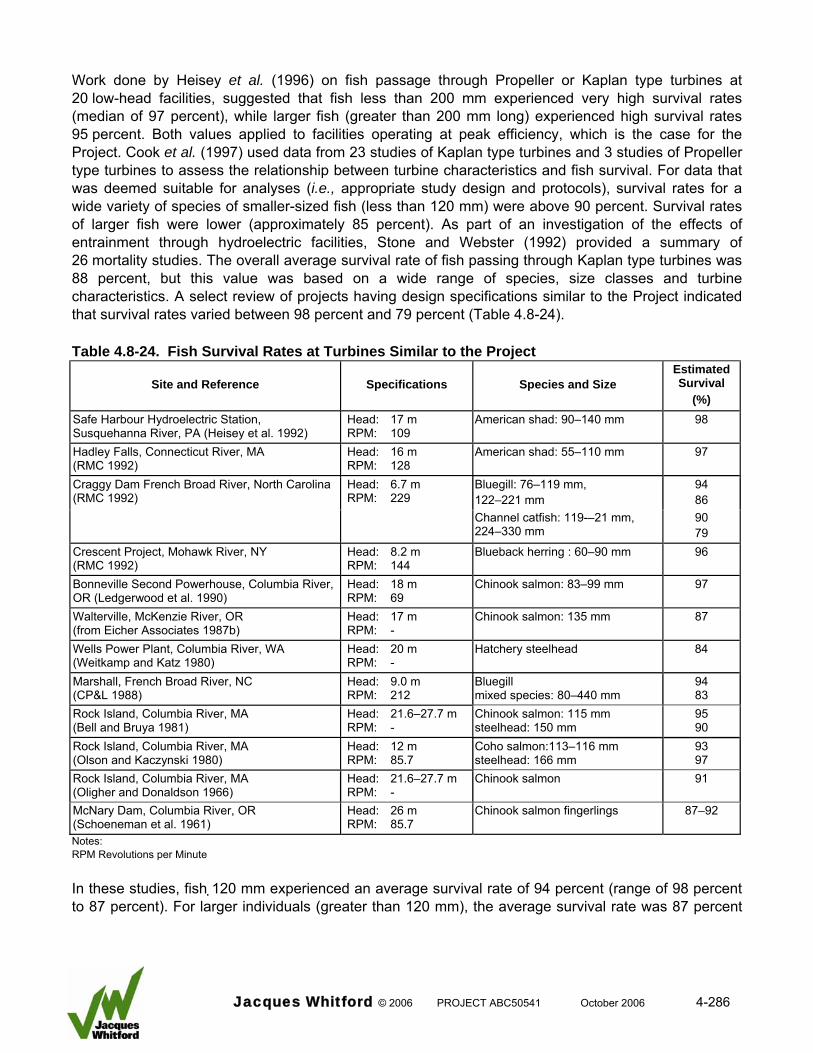
Work done by Heisey et al. (1996) on fish passage through Propeller or Kaplan type turbines at 20 low-head facilities, suggested that fish less than 200 mm experienced very high survival rates (median of 97 percent), while larger fish (greater than 200 mm long) experienced high survival rates 95 percent. Both values applied to facilities operating at peak efficiency, which is the case for the Project. Cook et al. (1997) used data from 23 studies of Kaplan type turbines and 3 studies of Propeller type turbines to assess the relationship between turbine characteristics and fish survival. For data that was deemed suitable for analyses (i.e., appropriate study design and protocols), survival rates for a wide variety of species of smaller-sized fish (less than 120 mm) were above 90 percent. Survival rates of larger fish were lower (approximately 85 percent). As part of an investigation of the effects of entrainment through hydroelectric facilities, Stone and Webster (1992) provided a summary of 26 mortality studies. The overall average survival rate of fish passing through Kaplan type turbines was 88 percent, but this value was based on a wide range of species, size classes and turbine characteristics. A select review of projects having design specifications similar to the Project indicated that survival rates varied between 98 percent and 79 percent (Table 4.8-24). Table 4.8-24. Fish Survival Rates at Turbines Similar to the Project
Site and Reference Specifications Species and Size Estimated Survival
(%) Safe Harbour Hydroelectric Station, Susquehanna River, PA (Heisey et al. 1992)
Head: 17 m RPM: 109
American shad: 90–140 mm 98
Hadley Falls, Connecticut River, MA (RMC 1992)
Head: 16 m RPM: 128
American shad: 55–110 mm 97
Bluegill: 76–119 mm, 122–221 mm
94 86
Craggy Dam French Broad River, North Carolina (RMC 1992)
Head: 6.7 m RPM: 229
Channel catfish: 119-–21 mm, 224–330 mm
90 79
Crescent Project, Mohawk River, NY (RMC 1992)
Head: 8.2 m RPM: 144
Blueback herring : 60–90 mm 96
Bonneville Second Powerhouse, Columbia River, OR (Ledgerwood et al. 1990)
Head: 18 m RPM: 69
Chinook salmon: 83–99 mm 97
Walterville, McKenzie River, OR (from Eicher Associates 1987b)
Head: 17 m RPM: -
Chinook salmon: 135 mm 87
Wells Power Plant, Columbia River, WA (Weitkamp and Katz 1980)
Head: 20 m RPM: -
Hatchery steelhead 84
Marshall, French Broad River, NC (CP&L 1988)
Head: 9.0 m RPM: 212
Bluegill mixed species: 80–440 mm
94 83
Rock Island, Columbia River, MA (Bell and Bruya 1981)
Head: 21.6–27.7 m RPM: -
Chinook salmon: 115 mm steelhead: 150 mm
95 90
Rock Island, Columbia River, MA (Olson and Kaczynski 1980)
Head: 12 m RPM: 85.7
Coho salmon:113–116 mm steelhead: 166 mm
93 97
Rock Island, Columbia River, MA (Oligher and Donaldson 1966)
Head: 21.6–27.7 m RPM: -
Chinook salmon 91
McNary Dam, Columbia River, OR (Schoeneman et al. 1961)
Head: 26 m RPM: 85.7
Chinook salmon fingerlings 87–92
Notes: RPM Revolutions per Minute In these studies, fish 120 mm experienced an average survival rate of 94 percent (range of 98 percent to 87 percent). For larger individuals (greater than 120 mm), the average survival rate was 87 percent
Jacques Whitford © 2006 PROJECT ABC50541 October 2006 4-286
(range of 97 percent to 79 percent). Although no data were presented specifically for larger fish (greater than 250 mm), it can be assumed that survival rates would be lower. Based on the findings of Alden Research (2001) and a review of the literature it is assumed that fish survival during turbine passage at the Project will be as follows: • 95 percent survival of fish less than 100 mm in length
• 90 percent survival of fish between 100 and 199 mm in length
• 88 percent survival of fish between 200 and 299 mm in length
• 83 percent survival of fish equal to or greater than 300 mm in length The magnitude of potential adverse effect on fish health and survival was evaluated for each species population expected to occur in the Project (Table 4.8-25). The evaluation was based on each populations expected movement strategy relative to the trash rack exclusion period, the expected portion of the population that is expected to pass the headworks during the annual movement cycle, and the predicted survival rate (all size-classes combined) of fish that do pass through the turbines. Table 4.8-25: Summary of Effects of Turbines on Fish Health and Survival
Potential for Downstream
Movement Outside Exclusion Perioda
Portion of Population Affecteda
Expected Survival Rate (All Sizes
Combined) (%)
Magnitude of EffectcMovement Strategy
Species Name
Immature Mature Immature Mature Immature Mature Immature Mature Resident Brook stickleback High Low Low Low 95 95 1 1
Burbot High High Moderate Moderate 90 83 1 2 Lake chub High Low Low Low 95 95 1 1 Longnose dace High Low Low Low 95 95 1 1 Longnose sucker High Moderate Low Low 90 88 1 1 Northern pike High Low Low Low 88 83 1 1 Redside shiner High Low Low Low 95 95 1 1 Slimy sculpin High Low Low Low 95 95 1 1 Spoonhead sculpin High Low Low Low 95 95 1 1 Trout-perch High Low Low Low 95 95 1 1 Spottail shiner High Low Low Low 95 95 1 1 Walleye High High Low Moderate 90 83 1 2 White sucker High Low Low Low 90 88 1 1
Migratory Flathead chub High Moderate Moderate Moderate 95 90 1 1 Goldeye - Low - Moderate 83 1 1
Transient Bull trout Moderate - Low - 83 1 1 Mountain whitefish Moderate Moderate Moderate Moderate 90 88 1 2
Incidental Arctic grayling Low Low Low Low 90 88 1 1 Kokanee Low Low Low Low 95 95 1 1 Lake whitefish Low Low Low Low 90 83 1 1 Northern pikeminnow Low Low Low Low 90 83 1 1 Rainbow trout Low Low Low Low 90 88 1 1
Unique Fathead minnow Low Low Low High >95 >95 1 1 Notes: a Rating based on predicted movement strategy of species population in project area (Mainstream 2006a). b Immature fish of large-sized species and all fish of small-sized species received a high rating regardless of movement strategy because they will
not be excluded by trash racks. c 1 = <10 % loss of important habitat or <10 % change in fish population abundance or hindered movement of small portion of the fish population. 2 = Moderate: 10 to 20 % loss of important habitat or 10 to 20 % change in fish population abundance or hindered movement of a portion of the
fish in the population.
Jacques Whitford © 2006 PROJECT ABC50541 October 2006 4-287
Based on this evaluation most fish populations (21 of 23 species) received a low rating for magnitude of effect (i.e., less than 10 percent of the population would be adversely affected by headworks turbine operation). Three species, burbot, walleye and mountain whitefish received a rating of moderate (10 percent to 20 percent of the population potentially affected). This was due primarily to the presence of adult fish in the project area, and the movement strategy of these populations that may cause fish to move past the headworks structure when the exclusion trash racks are not in place. Summary of Effects on Fish Health and Survival Glacier Power has developed a comprehensive, state of the art mitigation strategy in order to maximize fish health and survival. Based on the mitigation measures to be applied the potential effects of headworks operation on fish health and survival will be largely mitigated; however, some residual effects will remain following mitigation. Downstream movement strategies of some fish species populations in the project area will make them susceptible to spillway or turbine entrainment. Given the spillway design, period of operation, and amount of water spilled versus total available flow, the adverse effects on fish health and survival during spillway passage are expected to be small. The mitigation strategy to be used during turbine operation will protect the majority of fish populations including goldeye, which are known to be migratory. However, some resident species populations, including burbot and walleye will be susceptible to turbine entrainment. A portion of these populations consist of adult fish that will suffer reduced survival rates during turbine passage. As such, there is the potential for an adverse effect of headworks operation on fish health and survival. Whether the adverse effect is significant and the ramifications of this on fish populations are discussed in detail in Sections 4.8.5.6.2 and 4.8.5.7, respectively. 4.8.5.2.3 Fish Movements 4.8.5.2.3.1 Headworks Structure The headworks structure will physically block upstream and downstream fish movements without mitigation. Glacier Power has committed to a comprehensive mitigation strategy to protect fish populations from the adverse effects of hindered movement (NHC 2006b, Section 3.6). To achieve this goal Glacier Power has completed extensive work to maximize its understanding of movement requirements of fish populations potentially affected by the Project (RL&L 2000b, Mainstream 2004a, 2006a, and 2006b). Glacier Power has completed an extensive evaluation and modelling program to develop a fish passage strategy that will achieve its goal: to provide effective fish passage to ensure the long-term viability of fish populations (NHC 2006b, Project Description). This work was carried out in close consultation with DFO and ASRD. This evaluation will provide a summary of the fish system and operation strategy for upstream and downstream fish passage that will be used to mitigate effects on fish movement during project operations. This will be followed by an evaluation of the effectiveness of mitigation in relation to movement patterns of fish populations in the LSA.
Jacques Whitford © 2006 PROJECT ABC50541 October 2006 4-288
Mitigation The following has been summarized from information presented in NHC (2006b) and the Project Description. The reader is referred to those documents for a more in depth discussion. The rationale and objectives of the fish passage strategy are as follows: • downstream passage:
o exclude the adult component of the fish population from turbine entrainment; o minimize the potential for impingement against the trash racks; o guide excluded fish to fish sluiceways to provide safe downstream passage; and o allow smaller-sized, non-adult fish to pass through the trash racks and turbine units (the
smaller-sized fish will have a high survival rate).
• upstream passage: o provide effective passage conditions for fish greater than 150 mm in length.
The fish passage structures and operation strategy were arrived at through an extensive hydraulic modelling program designed to test proposed fish passage structures in an adaptive management framework to arrive at the best practical solution with ideal hydraulics and highest efficiencies. Modelling was used to confirm the hydraulic design criteria and assumptions prior to the final design and construction of the facility. And, it was used to provide a high level of confidence for the regulators in the hydraulic performance of the structure with respect to fish passage requirements. Modelling allowed integration of several criteria and operational objectives for fish passage strategies as follows: • Ecohydraulic Criteria:
o design hydraulics are based on conservative assumptions related to fish swimming capabilities, fish habitat preferences, and fish movement strategies
• Connectivity: o the design provides multiple, safe movement pathways with suitable hydraulic conditions
through the Project.
• Positive Hydraulic Gradients: o hydraulic conditions provide well distributed flows through the range of project operation
conditions.
• Adaptive: o structures are capable of providing fish passage through a range of operational hydraulic
conditions and range of potential inflows.
• Viability: o structures are technically viable and functional under all operating conditions and are
constructible.
• Contingency: o the strategy is designed to accommodate contingency actions (adaptive operations and
management strategies) to provide effective fish passage as required. The fish passage facilities that have been designed and modeled for the Project are illustrated in Figures 3.1-2 and 3.2-1.
Jacques Whitford © 2006 PROJECT ABC50541 October 2006 4-289
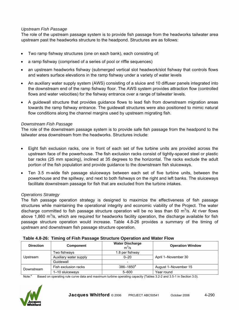
Upstream Fish Passage The role of the upstream passage system is to provide fish passage from the headworks tailwater area upstream past the headworks structure to the headpond. Structures are as follows:
• Two ramp fishway structures (one on each bank), each consisting of:
• a ramp fishway (comprised of a series of pool or riffle sequences)
• an upstream headworks fishway (submerged vertical slot headwork/slot fishway that controls flows and waters surface elevations in the ramp fishway under a variety of water levels
• An auxiliary water supply system (AWS) consisting of a sluice and 10 diffuser panels integrated into the downstream end of the ramp fishway floor. The AWS system provides attraction flow (controlled flows and water velocities) for the fishway entrance over a range of tailwater levels.
• A guidewall structure that provides guidance flows to lead fish from downstream migration areas towards the ramp fishway entrance. The guidewall structures were also positioned to mimic natural flow conditions along the channel margins used by upstream migrating fish.
Downstream Fish Passage The role of the downstream passage system is to provide safe fish passage from the headpond to the tailwater area downstream from the headworks. Structures include:
• Eight fish exclusion racks, one in front of each set of five turbine units are provided across the upstream face of the powerhouse. The fish exclusion racks consist of tightly-spaced steel or plastic bar racks (25 mm spacing), inclined at 35 degrees to the horizontal. The racks exclude the adult portion of the fish population and provide guidance to the downstream fish sluiceways.
• Ten 3.5 m-wide fish passage sluiceways between each set of five turbine units, between the powerhouse and the spillway, and next to both fishways on the right and left banks. The sluiceways facilitate downstream passage for fish that are excluded from the turbine intakes.
Operations Strategy The fish passage operation strategy is designed to maximize the effectiveness of fish passage structures while maintaining the operational integrity and economic viability of the Project. The water discharge committed to fish passage structure operation will be no less than 60 m3/s. At river flows above 1,860 m3/s, which are required for headworks facility operation, the discharge available for fish passage structure operation would increase. Table 4.8-26 provides a summary of the timing of upstream and downstream fish passage structure operation. Table 4.8-26: Timing of Fish Passage Structure Operation and Water Flow
Direction Component Water Discharge m3/s Operation Window
Two fishways 1.8 per fishway Auxiliary water supply 0–20 Upstream Guidewall -
April 1–November 30
Fish exclusion racks 386–1850a August 1–November 15 Downstream 1–10 sluiceways 5–600 Year round
Note:a Based on operating rule curve data and maximum turbine operating capacity (Tables 3.2-2 and 3.5-1 in Section 3.0).
Jacques Whitford © 2006 PROJECT ABC50541 October 2006 4-290
Discharge committed to specific components of the fish passage system will depend on river flow and time of year. In general fishways will operate during the entire open water period (approximately April 1 to November 30), with the optimal design flow of 1.8 m3/s. Auxiliary water supply discharge would vary from 0 m3/s at 95 percent exceedance to 20 m3/s at 5 percent exceedance in order to create optimal attraction flows (Table 7 in NHC 2006b). Due to ice formation upstream fish passage structures cannot operate when water temperatures approach zero. Downstream fish passage structures will operate during the downstream movement period from August 1 to November 15. Fish exclusion racks will be in place during this period and sluiceways will be operational. The water discharge through the structures will vary depending on river flow and turbine operation. At full output, up to 1800 m3/s could pass through the exclusion racks. Due to ice formation fish exclusion racks cannot operate when water temperatures approach zero, and therefore will be removed. Sluiceways will continue to operate year round as water flows permit. Review of Existing Fish Passage Facilities The following has been excerpted from a review completed by Alden Research Laboratory (Alden 2006). The review was completed to provide documentation of fish passage efficiency and probability of success of passing the target fish species. A relatively large number of studies evaluating upstream passage of several freshwater species were identified. Most research was conducted with smallmouth bass, walleye, and northern pike. Information on the passage of non-game species (e.g., suckers, carps and minnows, catfish and bullheads) was less prevalent. The most common non-game species reported at upstream passage facilities were suckers (catostomids). In recent years, very few studies have evaluated the effectiveness of downstream passage technologies in diverting riverine fishes away from hydroelectric turbines. However, downstream protection or passage facilities have recently been installed or are being planned for many projects in the U.S. specifically for riverine fish. Although at many projects downstream passage targets non-game and game species, no data or information has been reported for most of the species of concern at the project site. Upstream passage of riverine fish has received considerable attention by fishery managers in recent years. The apparent need to keep rivers connected and open to upstream and downstream movements of resident fish populations has spurred considerable research over the past 10 to 15 years in the development of effective fishways for application with freshwater fishes throughout the world. Traditional fishway designs have been re-examined for their ability to pass nonsalmonids upstream and, more recently, nature-like bypass channels and rock ramps have been developed for the same purpose. Despite the recent interest in passing riverine fishes upstream, a review of fish passage mitigation in the U.S. conducted by the Federal Energy Regulatory Commission found that effectiveness evaluations have only been conducted at eight of the 43 non-federal projects where upstream passage facilities have been installed. Of these eight studies, only three produced meaningful data and none included an evaluation of passage rates for riverine fishes even though they were targeted for passage at
Jacques Whitford © 2006 PROJECT ABC50541 October 2006 4-291
12 facilities. Subsequently, there appears to be no existing data on upstream passage effectiveness of riverine fish at hydroelectric projects in the U.S. Many facilities, however, have documented the occurrence of riverine species using fishways, including at facilities designed specifically for anadromous migrants. The literature review found most upstream passage facilities designed for riverine fishes have been installed at low head weirs or dams that are used for purposes other than power production (Table 1 in Alden 2006). Of the six species of interest for the Project, walleye and northern pike have been extensively evaluated during studies examining the performance of upstream fish passage facilities. Some past studies and monitoring efforts have included data on the passage of species similar to those that are of concern at the Project. In particular, the passage of catostomids (sucker species) through several fishway types has been reported at many dams and weirs, which suggest that upstream passage of longnose sucker at the Project could be achieved through the use of several different fishway designs. Little information is available on upstream passage for goldeye, mountain whitefish, and burbot, all of which are species of interest for the Project. In an older study that monitored the passage of nonsalmonid fishes through vertical slot and Denil fishways at the Lesser Slave Lake weir in Alberta, northern pike, longnose sucker, and burbot were observed using both fishway types. Walleye and goldeye also were observed at this site, but neither of these species used the fishways during the evaluation, which may have been due in part to the weir being passable to fish during the study period due to high flows. Mountain whitefish have been reported to use a vertical slot ladder at the Carseland Weir in Alberta. Walleye upstream passage has been evaluated with Denil and vertical slot fishway designs and nature-like channels and ramps. The swimming speeds and behaviour of walleye as they move upstream has also been investigated during laboratory studies. These data indicate that Denil, vertical slot, and nature-like fishways all have potential to effectively pass walleye upstream. Walleye have also been documented using fish lifts at hydroelectric projects on several major U.S. rivers. Similar to walleye, northern pike upstream passage has been studied with different fishway designs and this species has been shown to use Denil, vertical slot, and nature-like bypass designs. Fishway evaluations generally have not been conducted with the other species of concern (goldeye, mountain whitefish, burbot, and longnose sucker). Despite a lack of studies, several fishways have been installed at weirs or dams where these species occur and, at some locations, the passage of one or more of these species has been documented, including weirs with Denil, vertical slot, and nature-like fishways (Table 2 in Alden 2006). Most downstream passage facilities have targeted anadromous migrants. The primary means for protecting riverine fishes at hydroelectric projects in the U.S. has been the use of narrow-spaced bar racks, which typically have clear spacings of 1 to 2 inches. These facilities may be accompanied by a downstream bypass, but many installations are designed only to prevent turbine entrainment and loss of reservoir fish. Although prescribed by resource agencies at many projects in the U.S., few studies have been conducted at existing installations to determine their effectiveness in minimizing entrainment of target species. A review of downstream passage mitigation found that effectiveness evaluations were conducted at 12 projects, of which only one focused on riverine fish species. This study was conducted at the Hudson Falls Hydroelectric Project to estimate bypass efficiency rates for 45-degree angled bar
Jacques Whitford © 2006 PROJECT ABC50541 October 2006 4-292
racks with 1-inch clear spacing and a single bypass at the downstream end of the structure. Bypass efficiency rates were low (less than 50 percent) at Hudson Falls and they were similar to those reported for laboratory studies conducted with several riverine species and 45-degree angled bar racks with 2-inch clear spacing. Although the Hudson Falls study demonstrates that 45-degree bar racks may not be an effective downstream passage measure for the species tested, the results are not completely relevant to the Project because none of the species of interest were evaluated and the 45-degreen bar rack design is very different than what has been proposed for preventing entrainment at the project intake (i.e., vertically sloping bar racks with multiple surface and submerged bypasses). Behavioural deterrents or guidance systems (strobe lights, underwater sound, and turbulent flow paths) have been evaluated with many species as means to reduce entrainment at hydroelectric projects. Recent studies have focused on diversion of salmonid species and repulsion of riverine or resident species at cooling water intakes. Despite a relatively large number of studies conducted in the lab and field during the past 50 years, very little information exists to support the use or behavioural deterrents. In particular, an evaluation of strobe light and sound at a hydroelectric power project in Wisconsin concluded that none of the fish collected during entrainment sampling were effectively repelled by either device. However, the only species collected during this study that is a species of concern for the Project was walleye; similar species included several catostomids (suckers). Currently, no information appears to be available on the behavioural responses of hiodontids (goldeye and mooneye), coregonines (whitefish species), esocids (pike and pickerel), and lotids (burbot) to any type of behavioural deterrent. Responses of fish to behavioural deterrents often are highly species- and size-specific, which makes it even more unlikely that a behavioural technology would be effective in protecting all of the species of interest at the Project. The results of the literature search and review did not allow for definitive summary statistics to be developed on the use and effectiveness of upstream and downstream passage facilities for the species of concern that may be affected by the Project. Very few upstream and downstream fish passage studies have been conducted at hydroelectric projects with riverine species either the same or similar to those that will occur at the Project. However, upstream passage facilities have been installed and evaluated at a number of non-hydropower dams and weirs in Europe, the U.S. and Canada. Many of these facilities have been installed for passing some of the species of interest at the Project and the results from evaluations that have been conducted indicate that Denil, vertical slot, and nature-like fishways could be considered state-of-the-art for all of the species of interest depending on site-specific design considerations. For downstream passage, the results of the literature review indicate that there are no state-of-the-art technologies that could be used on a widespread basis for safely passing the species of interest for the Project. Although narrow-spaced bar racks appear to be the most prevalent means for protecting riverine fishes at U.S. hydroelectric projects, there has been little data collected to determine their effectiveness. However, the few studies that have been conducted with narrow-spaced bar racks support the use of this approach for preventing entrainment simply because they act as a physical barrier (as well as a behavioural barrier to some species). If riverine fish are required to be passed downstream one or more downstream bypasses (e.g., sluiceways) need to be provided. Because fish responses to behavioural guidance technologies can be highly species and size-specific, they are unlikely to provide effective deterrence for all of the species and size classes of fish that will have to be passed downstream.
Jacques Whitford © 2006 PROJECT ABC50541 October 2006 4-293
Effects Evaluation The following section presents assumptions used to evaluate effects of headworks operation on fish movement, a general discussion of potential effects on the fish groups found in the project area, and an examination of potential effects based on predicted movement patterns of specific fish species. Assumptions Four assumptions are adhered to by the effects evaluation as follows:
• The hydraulic characteristics of the upstream and downstream fish passage structures are sufficient to meet all fish passage objectives. For example, it is assumed that fish as small as 150 mm length are capable of moving through the fishways without undo delay. It is acknowledged that several questions can be posed regarding whether the hydraulic characteristics of the fish passage structures are sufficient to meet the fish passage objectives. The reader is directed to the Fish Passage Rationale document (NHC 2006b) for a detailed discussion and justification for the hydraulic characteristics used. This effects evaluation will not examine these questions.
• Headworks operation does not hinder downstream fish passage because pathways that allow downstream movement operate at all times. Two points are noted regarding this assumption. First, the hydraulic characteristics of the downstream fish passage structures are sufficient to meet all fish passage objectives. Second, potential mortality of fish that pass downstream is not addressed in this evaluation (See Section 4.8.5.2.2 for evaluation of headworks operation on fish survival).
• Fish belonging to migratory, resident, and transitory species populations undertake upstream and downstream movements to access important habitats as part of their life history strategy.
• Fish belonging to incidental and unique groups are assumed not to undertake distinct upstream and downstream movements as part of the population’s life history strategy. This assumption is deemed appropriate given the paucity of individual fish (incidental) or the isolated nature of the population (unique).
General Evaluation In general, the effect of headworks operation on upstream fish movement is dependent on the population type. The boundaries of fish populations in the Peace River are defined, in part, by the availability of important habitats and the strategies employed by fish species to access those habitats. Resident species recorded in the project area are widely distributed in the Peace River system. Because these species do not undertake extensive upstream movements, critical habitats required by these fish must also be widely distributed. If a barrier blocks access to a critical habitat, then the local biological population that requires access would be severely affected, but the regional population would remain viable due to the availability of the habitat elsewhere in the system. As such adverse effects on a local resident population are high, but the regional population would not be affected. This approach applies to a sub-group within the resident species group. Due to their size, no individuals of smaller-sized species (less than 150 mm length) would be able to pass upstream through the fishways with certainty. However, this entire sub-group of small fish species would be affected the same way as larger-sized resident fish species. The effects would be restricted to the local population, but not the regional population.
Jacques Whitford © 2006 PROJECT ABC50541 October 2006 4-294
In contrast to resident species, migratory fish species rely on large-scale movements to access critical habitats, which may or may not be restricted in distribution. A migratory population can be widely distributed in the Peace River, but if it is excluded from a critical habitat that has a restricted distribution, then viability of the entire population would be negatively affected. It is unknown whether critical habitats used by migratory populations are restricted in distribution within the Peace River. Based on the movement strategy employed, one can assume that some or all critical habitats are restricted. If so, hindered movements of migratory fish would have an adverse effect on the population and this effect would be widespread. Transitory species present in the project area do not constitute self-sustaining populations, nor will their exclusion from important habitats adversely affect the parent population that resides outside the project area. As such, hindered movement of these fish would have no adverse effect. Species Specific Evaluation The effects of headworks operation on upstream fish movements would be species-specific based on the species population’s movement strategy and the fish passage structure operation. Table 4.8-27 summarizes this information and provides a rating of the species-specific magnitude of effect using the definition presented in Section 4.8.4. Table 4.8-27: Upstream Fish Population Movement - Timing, Predicted Success and Effect
Species-specific Information Upstream Movement Outside Operation
Window of Fish Passage Structure
Upstream Passage Success
Magnitude of Effect on MovementaMovement
Strategy Species Name
Immature Mature Immature Mature Immature Mature Resident Brook stickleback No No No No 3 3 Burbot No Yes Partial No 2 Lake chub No No No No 3 3 Longnose dace No No No No 3 3 Longnose sucker No No Partial Yes 2 Northern pike No No Partial Yes 2 Redside shiner No No No No 3 3 Slimy sculpin No No No No 3 3 Spoonhead sculpin No No No No 3 3 Trout-perch No No No No 3 3 Spottail shiner No No No No 3 3 Walleye No No Partial Yes 2 White sucker No No Partial Yes 2 Migratory Flathead chub No No No Yes 3 1 Goldeye - No - Yes Transient Bull trout No - Yes - Mountain whitefish No No Partial Yes 3 Incidental Arctic grayling No No Partial Yes 2 Kokanee No No Partial Yes 2 Lake whitefish No No Partial Yes 2 Northern pikeminnow No No Partial Yes 2 Rainbow trout No No Partial Yes 2 Unique Fathead minnow No No No No 3 3 Notes: a 1 = <10 % loss of important habitat or <10 % change in fish population abundance or hindered movement of small portion of the fish
population. 2 = Moderate: 10 to 20 % loss of important habitat or 10 to 20 % change in fish population abundance or hindered movement of a
portion of the fish in the population. 3 = High: >20 % loss of important habitat or >20 % change in fish population abundance or hindered movement of all fish in the
population.
Jacques Whitford © 2006 PROJECT ABC50541 October 2006 4-295
Based on a review of fish species movement strategies, the location of important habitats, and the operation strategy of the fish passage structures, the magnitude of the adverse effect on fish movement is considered low for the majority of large-fish species and high for all small-fish species. This is due to these factors:
• upstream fish passage structures will be operating when the majority of fish are expected to move upstream
• the structure are designed to pass fish greater than 150 mm in length
• small fish less than 150 mm length may be able to pass upstream Burbot was the only large fish species that received a moderate rating for magnitude of effect. Movement studies completed in the project area indicate that burbot undertake upstream movements during the winter period (Mainstream 2006c), when the upstream passage facilities would not be operational. These movements are most likely to post-spawning feeding habitats. A higher magnitude of effect was not chosen because spawning habitats also were present downstream from the headworks facility and most study fish used these areas rather than upstream locations (Mainstream 2006b). By default all small-fish species received a high magnitude of effect rating because it is assumed that upstream passage will be largely blocked. Summary of Effects on Fish Movements Based on the comprehensive mitigation measures to be applied most large-fish species will be able to move upstream and all fish will be able to move downstream past the facility. As such, the potential effect of headworks operation on fish movement will be largely mitigated. The only exception is for the large-fish species burbot, which potentially will move upstream when the fishways are not operational. Also, upstream movements of small-fish species potentially will be blocked because the fishways are designed to pass fish 150 mm in length and largely. Based on this assessment there is the potential for an adverse effect on fish movement in the project area. The significance of this residual effect and its consequences to fish populations are examined in detail in Sections 4.8.5.6.2 and 4.8.8, respectively. 4.8.5.3 Decommissioning Phase Table 4.8-28 is an environmental effects assessment matrix for the fish community during decommissioning. Project activities and the potential effects evaluated include: • infrastructure removal:
o increased suspended sediments o loss or alteration of fish habitat
• dewatering headpond: o increased fish habitat complexity and quality
Jacques Whitford © 2006 PROJECT ABC50541 October 2006 4-296
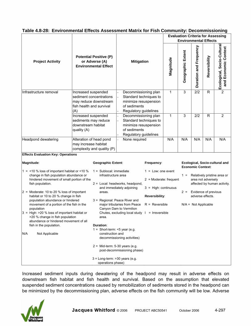
Table 4.8-28: Environmental Effects Assessment Matrix for Fish Community: Decommissioning
Evaluation Criteria for Assessing Environmental Effects
Ecol
ogic
al, S
ocio
-Cul
tura
l an
d Ec
onom
ic C
onte
xt
Project Activity Potential Positive (P)
or Adverse (A) Environmental Effect
Mitigation
Mag
nitu
de
Geo
grap
hic
Exte
nt
Dur
atio
n an
d Fr
eque
ncy
Rev
ersi
bilit
y
Increased suspended sediment concentrations may reduce downstream fish health and survival (A)
− Decommissioning plan − Standard techniques to
minimize resuspension of sediments
− Regulatory guidelines
1 3 2/2 R 2 Infrastructure removal
Increased suspended sediments may reduce downstream habitat quality (A)
− Decommissioning plan − Standard techniques to
minimize resuspension of sediments
− Regulatory guidelines
1 3 2/2 R 2
Headpond dewatering Alteration of head pond may increase habitat complexity and quality (P)
− None required N/A N/A N/A N/A N/A
Effects Evaluation Key: Operations Magnitude: 1 = <10 % loss of important habitat or <10 %
change in fish population abundance or hindered movement of small portion of the fish population.
2 = Moderate: 10 to 20 % loss of important
habitat or 10 to 20 % change in fish population abundance or hindered movement of a portion of the fish in the population
3 = High: >20 % loss of important habitat or >20 % change in fish population abundance or hindered movement of all fish in the population.
N/A Not Applicable
Geographic Extent: 1 = Sublocal: immediate
infrastructure area 2 = Local: headworks, headpond,
and immediately adjoining areas.
3 = Regional: Peace River and
major tributaries from Peace Canyon Dam to Vermilion Chutes, excluding local study area.
Duration: 1 = Short-term: <5 year (e.g.
construction and decommissioning activities)
2 = Mid-term: 5-30 years (e.g.
post-decommissioning phase) 3 = Long-term: >30 years (e.g.
operations phase)
Frequency: 1 = Low: one event 2 = Moderate: frequent 3 = High: continuous Reversibility: R = Reversible I = Irreversible
Ecological, Socio-cultural and Economic Context: 1 = Relatively pristine area or
area not adversely affected by human activity.
2 = Evidence of previous
adverse effects. N/A = Not Applicable
Increased sediment inputs during dewatering of the headpond may result in adverse effects on downstream fish habitat and fish health and survival. Based on the assumption that elevated suspended sediment concentrations caused by remobilization of sediments stored in the headpond can be minimized by the decommissioning plan, adverse effects on the fish community will be low. Adverse
Jacques Whitford © 2006 PROJECT ABC50541 October 2006 4-297
effects will most likely occur during the first few months of the decommissioning phase; however, elevated sediment loads may continue to occur at least once annually (i.e., during spring freshet) for at least 30 years. The geographic extent of the effect is not known, but it is expected to influence the headpond zone and several kilometres of river downstream from the headworks structure. It is assumed that the adverse effects on fish will be highest in the section of river downstream from the headworks where suspended sediment loads and sedimentation will be highest, but it is expected that adverse effects would extend much farther downstream. The majority of the species populations in the project area are adapted to high suspended sediment loads. Based on the assumption that the decommissioning plan will minimize the remobilization of sediments in the headpond area and the fish community is pre-adapted to high sediment loads, the potential for an adverse effect is considered low for fish health and survival. The effects of dewatering in the headpond are predicted to be positive in terms of effects on fish habitat. Habitat complexity and quality are expected to increase as the river channel within the headpond returns to its pre-development state. 4.8.5.4 Malfunctions and Accidents Although very unlikely to occur certain accidents or malfunctions could result in potential adverse effects. Table 4.8-29 is an environmental effects assessment matrix for the fish community during malfunctions and accidents. Project activities and the potential effects evaluated include: • infrastructure failure:
o increased suspended sediments o contaminant inputs o loss or alteration of fish habitat o hindered fish movements
• major spill of toxic materials: o contaminants may be toxic to fish o loss or alteration of fish habitat during cleanup
• massive slope failure: o increased sediment inputs o removal of fish habitat o hindered fish movements
Jacques Whitford © 2006 PROJECT ABC50541 October 2006 4-298
Table 4.8-29: Environmental Effects Assessment Matrix for Fish Community: Accidents and Malfunctions
Evaluation Criteria for Assessing Environmental Effects
Project Activity
Potential Positive (P) or Adverse (A)
Environmental Effect Mitigation
Mag
nitu
de
Geo
grap
hic
Exte
nt
Dur
atio
n an
d Fr
eque
ncy
Rev
ersi
bilit
y
Ecol
ogic
al, S
ocio
-Cul
tura
l an
d Ec
onom
ic C
onte
xt
Increased suspended sediments (A) − None available N/A 1 2/1 R 2
Elevated contaminant (A) − Standard mitigation techniques
− Regulatory guidelines
N/A 1 1/1 R 2
Loss or alteration to downstream fish habitat (A)
− None available 1 1 2/1 R 2
Infrastructure failure
Hindered fish movements (A) − Mitigate by opening all turbine ports or spillway bays
N/A 1 2/1 R 2
Elevated contaminants (A) − Standard mitigation techniques
− Regulatory guidelines − Spill response plan
2 1 1/1 R 2 Major spill of toxic materials
Disturbance of habitat during cleanup (A)
− Spill response plan N/A 1 1/1 R 2
Elevated sediment concentrations (A) − None available 1 3 1/1 R 2
Removal of fish habitat (A) − None available 1 1 1/1 I 2
Massive slope failure
Hindered upstream fish movements (A) − None available N/A 1 1/1 I 2 Effects Evaluation Key: Operations Magnitude: 1 = <10 % loss of important habitat or
<10 % change in fish population abundance or hindered movement of small portion of the fish population.
2 = Moderate: 10 to 20 % loss of important
habitat or 10 to 20 % change in fish population abundance or hindered movement of a portion of the fish in the population
3 = High: >20 % loss of important habitat or
>20 % change in fish population abundance or hindered movement of all fish in the population.
N/A Not Applicable
Geographic Extent: 1 = Sublocal: immediate
infrastructure area 2 = Local: headworks, headpond,
and immediately adjoining areas.
3 = Regional: Peace River and
major tributaries from Peace Canyon Dam to Vermilion Chutes, excluding local study area.
Duration: 1 = Short-term: <5 year (e.g.
construction and decommissioning activities)
2 = Mid-term: 5-30 years (e.g.
post-decommissioning phase)
3 = Long-term: >30 years (e.g. operations phase)
Frequency: 1 = Low: one event 2 = Moderate: frequent 3 = High: continuous Reversibility: R = Reversible I = Irreversible
Ecological, Socio-cultural and Economic Context: 1 = Relatively pristine
area or area not adversely affected by human activity.
2 = Evidence of
previous adverse effects.
N/A = Not Applicable
Jacques Whitford © 2006 PROJECT ABC50541 October 2006 4-299
Sediment Inputs Extreme bank erosion due to a flood event, catastrophic failure of the infrastructure, and massive slope failure have the potential to generate large sediment inputs. Built in safeguards have been incorporated into the project design to prevent infrastructure failure due to a design flaw; however, if infrastructure failure or the other accidents occurred, no mitigation measures would be available to minimize sediment inputs. Infrastructure failure and bank erosion would most likely be associated with peak discharges of a flood event. Because suspended sediment loads would be at their highest during these conditions, the incremental input of sediments resulting from these accidents or malfunctions only minor adverse effects on the fish community would be expected. There could be adverse effects associated with massive slope failure. Large amounts of sediments would be associated with a slope failure. As such, the magnitude of increased sediment concentrations was rated as moderate and the geographic extent was rated as regional because river flows can carry sediment particles a considerable distance downstream. The effect would be short term. Slope stability is addressed in greater detail in Sections 4.3 and 4.6. Contaminant Inputs Failure of the headworks infrastructure has the potential to release contaminants into the environment. The primary contaminant source, lubricants used for the turbines, will be environmentally friendly or vegetable based; therefore, the potential for adverse effects from this source will be negligible. Another contaminant source involves a major spill of materials hauled to the construction site via the access roads across Hines and Dunvegan creeks (e.g., diesel fuel and concrete). Although unlikely to occur, an accident involving transport vehicles in the vicinity of the stream crossing, may release contaminants into the aquatic environment. Limiting the amount and type of hazardous materials transported to the construction site can minimize the potential for release of a large amount of toxic materials into the aquatic environment due to an accidental spill. All vehicle fuelling will be completed offsite; therefore, uncured concrete will be the only toxic material that will be transported onsite in large amounts. In the event of a transport vehicle upset, an emergency response plan will be in place to deal with spills. This will allow a rapid and effective response to contain the spill and initiate cleanup procedures. In the event that the spill occurs in close proximity to the water, some materials may enter the aquatic environment; therefore, mitigation may not be completely effective. An accidental spill of a large volume of uncured concrete into Hines or Dunvegan creeks would have an adverse effect on fish, but only in the affected stream sections and only during periods when fish are present (spring). The high pH of this material is the primary reason for adverse effects on aquatic organisms; pH values exceeding 9.0 are considered harmful to aquatic biota (CCME 1999). Water having elevated pH would be diluted upon entry into the Peace River and the effect substantially reduced. As such, the effect would be restricted to the short section of stream between the crossing and the confluence with the Peace River (approximately 300 m). A secondary effect on fish associated with a spill would involve disturbance of habitat during cleanup operations. Hines and Dunvegan creeks provide only limited amounts of habitat on a seasonal basis to the project area fish community. The sections potentially affected are likely used for spawning and egg incubation by sucker and cyprinid species during spring.
Jacques Whitford © 2006 PROJECT ABC50541 October 2006 4-300
Massive Slope Failure A massive slope failure in the headpond could physically remove fish habitat from production, but the probability of such a failure is extremely low. The potential effect of a massive slope failure on fish habitat is dependant on the size and location of the failure; however, the area removed by a slope failure would be negligible compared to habitats available in the remainder of the project area. Barriers to Upstream Fish Passage Two types of accidents or malfunctions, while unlikely, could create barriers to fish passage. Failure of the headworks infrastructure may involve the fishway, which will temporally reduce or eliminate its ability to pass fish. In the event of headworks failure all turbine ports and spillway bays could be opened to reduce water velocities and facilitate fish passage. A slope failure in the headpond of sufficient size may temporarily block upstream fish movements by creating a physical or velocity barrier. Catastrophic failure of the headworks is unlikely to occur, but if it did, it would probably be caused by a large flood event, which is a period when upstream fish movements would be minimal. Massive slope failure is also an unlikely event and if a bank failure into the Peace River did occur, it is unlikely the channel would be entirely blocked (AMEC 2006). If complete blockage occurred, the river would down cut through material very rapidly (MMA 2000b). In both cases there would be negligible effects to upstream fish passage. A summary of potential adverse effects on the fish community caused by malfunctions and accidents are: • no adverse effect expected from infrastructure failure or bank erosion
• adverse effects associated with massive slope failure, including loss of habitat, which would be reversible once the slope failure stabilized
• adverse effects on fish from accidental spill of a large volume of uncured concrete, but only in the affected stream sections and only during periods when fish are present, and adverse effects of cleanup operations through disturbance of habitat. The geographic extent of such spills would be restricted to the stream sections between the bridge crossings over the Hines and Dunvegan creeks and Peace River, such spills would occur infrequently, if ever, would be reversible and, as such, would not have a significant effect on water quality in the project area
• loss of important fish habitat due to massive slope failure, deemed extremely unlikely
• failure of the headworks infrastructure involving the fishways, thus reducing or eliminating their ability to pass fish, an event considered to be highly unlikely; however, if it did occur, it would probably be caused by a large flood event, which is a period when upstream fish movements would be minimal
• a slope failure in the headpond of sufficient magnitude as to temporarily block upstream fish movements by creating a physical or velocity barrier; massive slope failure is also an unlikely event and if a bank failure into the Peace River did occur, it is unlikely the channel would be entirely blocked. If complete blockage occurred, the river will down cut through material very rapidly. In both cases there would be negligible effects to upstream fish passage
Jacques Whitford © 2006 PROJECT ABC50541 October 2006 4-301
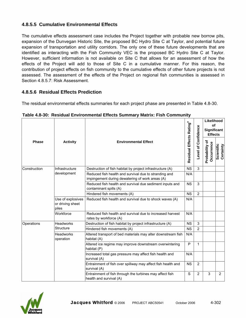
4.8.5.5 Cumulative Environmental Effects The cumulative effects assessment case includes the Project together with probable new borrow pits, expansion of the Dunvegan Historic Site, the proposed BC Hydro Site C at Taylor, and potential future expansion of transportation and utility corridors. The only one of these future developments that are identified as interacting with the Fish Community VEC is the proposed BC Hydro Site C at Taylor. However, sufficient information is not available on Site C that allows for an assessment of how the effects of the Project will add to those of Site C in a cumulative manner. For this reason, the contribution of project effects on fish community to the cumulative effects of other future projects is not assessed. The assessment of the effects of the Project on regional fish communities is assessed in Section 4.8.5.7: Risk Assessment. 4.8.5.6 Residual Effects Prediction The residual environmental effects summaries for each project phase are presented in Table 4.8-30. Table 4.8-30: Residual Environmental Effects Summary Matrix: Fish Community
Likelihood of
Significant Effects
Phase Activity Environmental Effect
Res
idua
l Effe
cts
Rat
inga
Leve
l of C
onfid
ence
Prob
abili
ty o
f O
ccur
renc
e Sc
ient
ific
Cer
tain
ty
Destruction of fish habitat by project infrastructure (A) NS 3 Reduced fish health and survival due to stranding and impingement during dewatering of work areas (A)
N/A
Reduced fish health and survival due sediment inputs and contaminant spills (A)
NS 3
Infrastructure development
Hindered fish movements (A) NS 2 Use of explosives or driving sheet piles
Reduced fish health and survival due to shock waves (A) N/A
Construction
Workforce Reduced fish health and survival due to increased harvest rates by workforce (A)
N/A
Operations Destruction of fish habitat by project infrastructure (A) NS 3
Headworks Structure Hindered fish movements (A) NS 2
Altered transport of bed materials may alter downstream fish habitat (A)
N/A
Altered ice regime may improve downstream overwintering habitat (P)
P 1
Increased total gas pressure may affect fish health and survival (A)
N/A
Entrainment of fish over spillway may affect fish health and survival (A)
NS 2
Headworks operation
Entrainment of fish through the turbines may affect fish health and survival (A)
S 2 3 2
Jacques Whitford © 2006 PROJECT ABC50541 October 2006 4-302
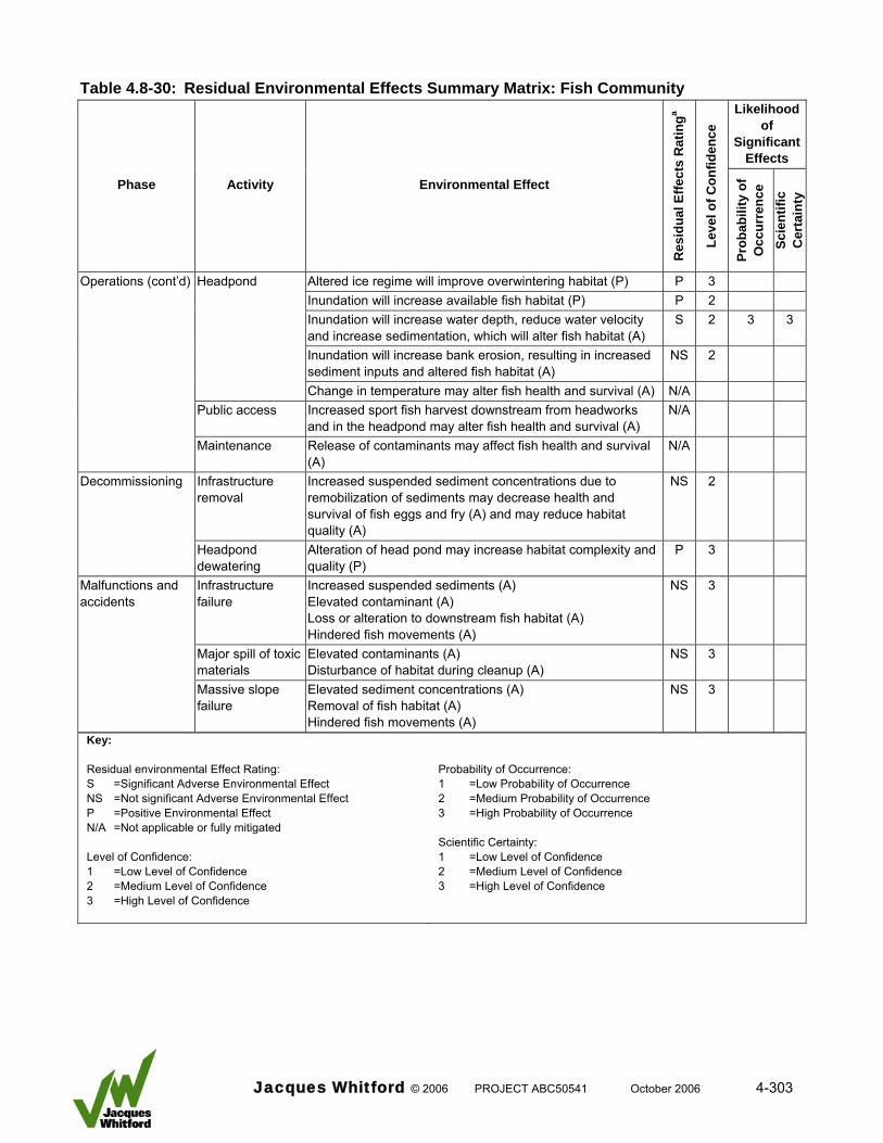
Table 4.8-30: Residual Environmental Effects Summary Matrix: Fish Community Likelihood
of Significant
Effects
Phase Activity Environmental Effect
Res
idua
l Effe
cts
Rat
inga
Leve
l of C
onfid
ence
Prob
abili
ty o
f O
ccur
renc
e Sc
ient
ific
Cer
tain
ty
Operations (cont’d) Headpond Altered ice regime will improve overwintering habitat (P) P 3 Inundation will increase available fish habitat (P) P 2 Inundation will increase water depth, reduce water velocity
and increase sedimentation, which will alter fish habitat (A) S 2 3 3
Inundation will increase bank erosion, resulting in increased sediment inputs and altered fish habitat (A)
NS 2
Change in temperature may alter fish health and survival (A) N/A Public access Increased sport fish harvest downstream from headworks
and in the headpond may alter fish health and survival (A) N/A
Maintenance Release of contaminants may affect fish health and survival (A)
N/A
Infrastructure removal
Increased suspended sediment concentrations due to remobilization of sediments may decrease health and survival of fish eggs and fry (A) and may reduce habitat quality (A)
NS 2 Decommissioning
Headpond dewatering
Alteration of head pond may increase habitat complexity and quality (P)
P 3
Infrastructure failure
Increased suspended sediments (A) Elevated contaminant (A) Loss or alteration to downstream fish habitat (A) Hindered fish movements (A)
NS 3
Major spill of toxic materials
Elevated contaminants (A) Disturbance of habitat during cleanup (A)
NS 3
Malfunctions and accidents
Massive slope failure
Elevated sediment concentrations (A) Removal of fish habitat (A) Hindered fish movements (A)
NS 3
Key: Residual environmental Effect Rating: S =Significant Adverse Environmental Effect NS =Not significant Adverse Environmental Effect P =Positive Environmental Effect N/A =Not applicable or fully mitigated Level of Confidence: 1 =Low Level of Confidence 2 =Medium Level of Confidence 3 =High Level of Confidence
Probability of Occurrence: 1 =Low Probability of Occurrence 2 =Medium Probability of Occurrence 3 =High Probability of Occurrence Scientific Certainty: 1 =Low Level of Confidence 2 =Medium Level of Confidence 3 =High Level of Confidence
Jacques Whitford © 2006 PROJECT ABC50541 October 2006 4-303

4.8.5.6.1 Construction Construction of infrastructure will cause residual effects in three ways: removal of fish habitat by the infrastructure footprint, reduced fish health and survival due to sediment inputs or contaminants spills, and hindered fish movements due to blockage of upstream fish passage. 4.8.5.6.1.1 Infrastructure Footprint The areas removed from production by the footprint of the project infrastructure provide habitat for fish; therefore, there is the potential for an adverse effect. For the purposes of the evaluation, there is no distinction between temporary loss of habitat during construction and permanent loss caused by operations. The affected areas are small relative to habitats available in the remainder of the project area and they contain no important habitats; therefore, habitat loss received a low magnitude of effect rating. All fish populations can adjust by utilizing habitats available in adjacent locations. Flow regulation from the Bennett Dam presently affects the availability of fish habitat in the project area as a result of diurnal fluctuations in water levels and alteration to the annual hydrograph (MSA 2006). Most of the near shore habitats in the mainstem Peace River that would be affected by the project infrastructure are presently negatively affected by the fluctuating flow regime. The habitats in the project area tributaries are presently subjected to large seasonal changes in flow, with channels becoming dry or near dry following spring freshet. As such, the value of tributary habitat presently available to the fish community is severely limited. Based on this information the infrastructure footprint would have no significant adverse effect on fish habitat. There is a high level of confidence in the evaluation. The evaluation is based on an assessment of detailed, quantitative pre-development baseline habitat data. 4.8.5.6.1.2 Sediment Inputs There is the potential for reduced fish health and survival due to sediment inputs during dredging and sheet pile driving. These effects will be localized, short-term and low magnitude. Land-use practices (agriculture and wood extraction) that are characteristic of the project area can increase sediment inputs into the aquatic environment (Hartman et al. 1996; Richards et al. 1996; Harding et al. 1998). Sediment levels of the Peace River in the project area are extremely high depending on the flow regime and time of year, which is a result of natural or manmade influences. The fish community has adapted to these conditions. As such, short-term, increased sediment inputs are not expected to result in a significant adverse effect on fish health and survival. The level of confidence for this rating is high due to good information on suspended sediment levels in the Peace River and the ecology of fish populations in the area.
Jacques Whitford © 2006 PROJECT ABC50541 October 2006 4-304
4.8.5.6.1.3 Hindered Fish Movements Construction of the headworks structure in the Peace River could result in potential blockage of upstream fish passage for at least two and at most three consecutive years. Downstream movements will not be hindered during construction. The fish community in the project area consists of several species populations, each with its own movement strategy. Most small-fish resident species populations (e.g., cyprinids) are not likely to require passage past the construction site due to a life history strategy that requires only short distance movements. Large-fish resident species populations may undertake upstream movements past the construction site in order to complete their life requisites. Movement and baseline studies indicate the entire populations do not require upstream passage. However, upstream movement of a portion of each population is likely to occur. Of the resident large-fish species populations in the project area, three are considered at risk: burbot and walleye are at a high risk, while longnose sucker is at a moderate risk. Migratory species populations such as flathead chub and goldeye are considered at greatest risk from blockage of upstream passage because a substantive portion of each of these populations may require passage past the construction site annually. A comprehensive fish collection and transfer program is proposed as mitigation. Monitoring of fish movements and the occurrence of fish concentrations below the construction site will be used as an early warning signal that upstream fish passage is blocked. As such, it is assumed that the fish collection and transfer program, assisted by use of attraction flows at strategic locations will provide effective mitigation. Passage can be facilitated for most fish populations considered at risk without excessive delay, thereby minimizing the detrimental effects of blocked upstream passage. The only exception is a portion of the burbot population, which may move upstream in late winter during the post-spawning period. Upstream passage of these fish would be delayed until spring when the mitigation program is implemented. As such, the blockage would be temporary. Based on this evaluation there would be no significant adverse effect to the fish community due to blockage of upstream fish movement during construction. There is a moderate level of confidence in this assessment due to potential logistical constraints that could reduce the effectiveness of the mitigation strategy. 4.8.5.6.2 Operations Residual effects associated with project infrastructure during the operations phase include loss of fish habitat and hindered fish movements. 4.8.5.6.2.1 Project Infrastructure Loss of Fish Habitat Loss of fish habitat by the infrastructure footprint is examined in Section 4.8.5.6.1. The evaluation concluded that the infrastructure footprint would have no significant adverse effect on fish habitat and there was a high level of confidence in the evaluation.
Jacques Whitford © 2006 PROJECT ABC50541 October 2006 4-305
Hindered Fish Movements The headworks structure has the potential to block upstream and downstream fish movement. Glacier Power has developed a comprehensive mitigation program that includes upstream and downstream passage structures and operations strategy. The initial effects evaluation was based on four assumptions:
• The hydraulic characteristics of the upstream and downstream fish passage structures are sufficient to meet all fish passage objectives.
• Headworks operation does not hinder downstream fish passage because pathways that allow downstream movement are available.
• Fish belonging to migratory, resident and transitory species populations undertake upstream and downstream movements to access important fish habitats as part of their life history strategy.
• Fish belonging to incidental and unique species populations are assumed not to undertake distinct upstream and downstream movements as part of the population’s life history strategy.
Based on the mitigation measures to be applied and the assumptions listed above, the potential effect of headworks structure operation on fish movements will be partially mitigated. There are two issues of concern (residual effects) that remain following mitigation. First, upstream passage by small-sized species will be blocked because fishways are not designed to pass fish less than 150 mm in length. Also, not all large-sized resident species populations will be able to move upstream unhindered. Burbot is a primary concern because this species requires upstream passage in winter when fishways are not operational. The residual adverse effects of the headworks structure on fish movements are considered not significant for two reasons. First, small-sized resident species populations (e.g., cyprinids) employ a life history strategy that includes only short distance movement. As such, it is highly unlikely that upstream passage is required in order to maintain these populations. Flathead chub is the exception because it is assumed to be migratory. But, a large portion of the adult component of this species population is greater than 150 mm (Mainstream 2006a); therefore, upstream passage is possible. Second, upstream movements of burbot past the headworks structure will be delayed and not permanently blocked because fishways will become operational starting in April of each year. The delay is expected to be from one to two months in duration and will occur after completion of spawning by adult fish. This delay is deemed acceptable because post-spawning movements are to feeding habitats. These movements are not time sensitive and feeding habitats are available downstream from the facility. The confidence in this evaluation is moderate based on good movement data and knowledge of the species population ecology. 4.8.5.6.2.2 Headworks Operation Residual effects associated with headworks operation include altered downstream fish habitat due to a new ice regime, reduced fish health and survival due to entrainment over the spillway and through the turbines.
Jacques Whitford © 2006 PROJECT ABC50541 October 2006 4-306
Improved Downstream Overwintering Fish Habitat The presence of the headworks will alter the ice regime and create an open water zone that would extend between 10 and 90 km downstream from the facility. The effects of an altered ice regime on fish habitat will be positive due to improvement in the amount and quality of overwintering habitat downstream from the headworks. The effects of the present ice regime on fish habitats in the Peace River have not been quantified in terms of quality and distribution. However, research on other river systems has clearly documented the adverse effects of ice (frazil and anchor) on overwintering fish habitat. Although the fish community downstream from the Project will benefit from the altered ice regime the significance of this benefit cannot be estimated with confidence. As such, a rating of not significant is provided. Reduced Fish Health and Survival due to Spillway Entrainment The adverse effect of spillway operation on fish health and survival is expected to be negligible for most fish species populations for the following:
• The proportion of available flow that will pass over the spillway is small compared to total river flow.
• No migratory species and few resident species populations will require downstream passage during the spillway operation period (April to June). Therefore, few fish would have the opportunity to use the spillway as a passage route. Movement data suggests that some adult longnose suckers and walleye may move downstream during this period. It is expected that only fish residing within a few kilometres of the structure would be susceptible to entrainment over the spillway. Juvenile mountain whitefish may also be entrained during spillway operation. These fish belong to a transient species population, which by definition is not viable.
• Literature suggests that fish that are entrained over the spillway will experience reasonable survival rates.
Based on this information the effect of spillway entrainment on fish health and survival is deemed not significant. This rating is given with a moderate level of confidence because information are lacking that quantifies the adverse effects of the proposed spillway energy dissipaters on project area species populations. Reduced Fish Health and Survival due to Turbine Entrainment Entrainment of some fish through the turbines may have an adverse effect on the fish community. The effect is related to reduced health and survival caused by passage through the turbines and not physical damage due to impingement on the trash rack in front of the turbines. The effects evaluation assumed that the fish passage mitigation structures and operation strategy will be effective. The goal of the program is to prevent all adult fish of large-sized species populations from passing downstream through the turbines when the exclusion trash racks are in place. As such, the magnitude of the effect is dependant on the movement strategy of a particular species population that puts it at risk, the survival rate during passage through the turbines, and the portion of the population that will attempt to pass through the turbines.
Jacques Whitford © 2006 PROJECT ABC50541 October 2006 4-307
All small-sized species populations (less than 150 mm) will be entrained because fish will pass through the trash racks. Since the exclusion racks (bar spacing of 25 mm) will be in position from August 1 to November 15, large-sized species populations will be excluded from turbine passage during the primary downstream movement period (August to October). It should be noted that goldeye, the only migratory large-fish species, is deemed to be at minor risk of entrainment. Species populations that will be at some risk include burbot, walleye, and mountain whitefish. Burbot undertake downstream movements in winter; therefore, adult burbot will not be excluded. The core downstream movement period for walleye occurs in October and November, but adult walleye also move downstream through the project area in May, June, and December. As such, adult burbot and walleye will not be fully protected by the exclusion trash racks. Mountain whitefish, which belong to a transient population, are only protected during their expected downstream movement period (September to November). Predicted survival rates of fish that do undertake turbine passage are dependant primarily on fish size. Survival rates of smaller fish (juveniles of large-sized species and all fish of small-sized species) are expected to exceed 90 percent. Survival rates for adult fish predicted to be 83 percent. The magnitude of effect on fish health and survival is predicted to be low for all small-sized species populations (less than 150 mm) because of the predicted high survival rate. The effect on large-sized species burbot, walleye, and mountain whitefish is expected to be moderate because some adult fish will move through the turbines and have a lower survival rate. The portion of each population that will be entrained is not known; therefore, it is conservatively assumed that there is a high probability for an adverse effect. Based on this conservative assumption, and on the effects assessment criteria in section 4.8.4, the results of the evaluation suggest that there would be a significant adverse effect on fish community health and survival caused by turbine entrainment. The implications of this potential effect on the fish community are discussed in detail in Section 4.8.5.7. There is a high level of confidence in the evaluation based on predicted survival rates and good baseline data that describes species population movement strategies. The probability of occurrence is high, but a moderate rating was provided for certainty. A precautionary approach to the significance evaluation was required due to the lack of information regarding the portion of each species population that would be entrained. 4.8.5.6.2.3 Headpond Formation Residual effects associated with headpond formation include positive effects due to improved overwintering habitat and increased availability of habitat caused by inundation, and negative effects that include alteration of fish habitat due to reduced water velocities and sedimentation and increased sediment inputs due to bank erosion. The evaluation did not include additional positive effects such as development of spawning habitat at the upstream end of the headpond due to bedload deposition because the temporal and spatial boundaries of this new habitat could not be established. Improved Fish Habitat The overall effect of headpond formation on fish habitat is deemed to be positive. There will be an increase in available habitats caused by inundation of previously dry areas. Inundation of previously dry areas would have marginal benefits to fish habitat due to the generally low quality of new habitats. As such, this positive effect is deemed not significant because of the limited gains in habitat quality.
Jacques Whitford © 2006 PROJECT ABC50541 October 2006 4-308
Headpond formation will cause large increases in several types of habitats for most species populations that include rearing, feeding, and overwintering. In particular, an increase in the amount of overwintering habitat is deemed to be important for the fish community because this habitat type is suspected of being limited (amount and distribution) by the present flow and ice regime caused by flow regulation by the Bennett Dam. Research in other systems has established that the absence of overwintering habitat can limit fish populations. Based on this information the increase in fish habitat caused by headpond formation is deemed to have a significant positive effect. There is a high level of confidence in the evaluation based on good quantitative data that describes habitat losses and gains caused by the Project. Degraded Fish Habitat Headpond formation would have a negative effect on certain habitats that are required by some species populations. This would occur by altering the physical characteristics that presently exist (water depth and velocity) and erosion of the Peace River and Ksituan riverbanks following inundation. Both changes would result in sedimentation due to deposition of sands. Sediment inputs caused by bank erosion will not significantly increase suspended sediment levels that presently exist (MMA 2006). Because fish habitat is presently influenced by large sediment loads of the Peace River the effect of sediment inputs from bank erosion on fish habitat are considered not significant. Sedimentation caused by sand deposition would adversely affect longnose sucker, burbot, walleye spawning habitat, which consist of clean rock materials. Bull trout and mountain whitefish rearing and feeding habitats, which also consist of rock materials, also would be adversely affected. A mitigation and compensation proposal (Mainstream 2006c) that is acceptable to regulatory authorities (DFO and ASRD) will be completed to offset alteration to fish habitats caused by headpond formation and other Project effects. From an ecological perspective, habitat compensation cannot be considered full mitigation because certain specie and life stages would still be adversely affects, therefore the negative effects on fish habitat caused by sedimentation are deemed significant. There is a high level of confidence in the evaluation due to good quantitative information regarding species population’s habitat requirements, baseline habitat conditions, and predicted changes caused by headpond formation. The consequences of degraded fish habitat caused by sedimentation and viability of the fish community are discussed in detail in Section 4.8.8. The overall consequences of headpond formation on fish habitat include a net gain in available fish habitat, as discussed in Section 4.8.5.7.2. 4.8.5.6.3 Decommissioning Decommissioning would involve infrastructure removal and dewatering of the headpond (Table 4.8-28). Residual effects would be increased sediment loads downstream from the headpond and alteration of fish habitat in the former headpond location. The effects of infrastructure removal are deemed not significant because decommissioning will occur in a controlled manner. It is assumed that the process will be adjusted to ensure minimal effects. Dewatering of the headpond is considered a positive significant effect because it will reverse the adverse effects associated with headpond formation. Habitat complexity and quality are expected to increase as the river channel returns to its pre-development state.
Jacques Whitford © 2006 PROJECT ABC50541 October 2006 4-309
4.8.5.6.4 Malfunctions and Accidents Although very unlikely to occur, certain accidents or malfunctions could result in infrastructure failure, a major spill of toxic materials or massive slope failure (Table 4.8-29). Built in safeguards have been incorporated into the project design to minimize each of these potential events. 4.8.5.6.4.1 Infrastructure Failure Although the headworks structure is designed to be overtopped and withstand extreme flood events (i.e., Probable Maximum Flood) infrastructure failure may be associated such an event. Failure could result in increased suspended sediment loads due to bank erosion, introduction of contaminants, and blockage of upstream fish passage. However, by itself, such an event would be catastrophic for fish populations with or without the Project. Infrastructure failure received a not significant rating for the following reasons. First, it is extremely unlikely to occur. Second, suspended sediment levels would be highest during flood events; therefore, the incremental input of sediments would be small. Third, the primary contaminant source, lubricants used for the turbines, will be environmentally friendly or vegetable based. Finally, upstream fish movements during a major flood event are unlikely. 4.8.5.6.4.2 Major Spill A major spill of materials could occur during construction via the access roads across Hines and Dunvegan creeks (e.g., diesel fuel and concrete). If an accident occurred involving these transport vehicles in the vicinity of the stream crossing, contaminants may enter the aquatic environment. Because only a small fraction of the project area fish community uses Hines and Dunvegan creeks and the extent of the effect of a large accidental spill would be restricted to the stream sections between the bridge crossings and the Peace River, the effect is assessed as not significant. 4.8.5.6.4.3 Slope Failure Massive slope failure could cause elevated sediment levels, block upstream fish passage, and remove fish habitat. Large amounts of sediments would be associated with a slope failure and local fish habitat would be lost. The duration of blocked fish passage likely would be short term. With the exception of lost habitat, the effects would be reversible once the slope failure stabilized. This effect received a rating of not significant due to the extremely low probability that a massive slope failure into the headpond would occur (AMEC 2004). 4.8.5.7 Risk Assessment A significant adverse effect on the fish community is defined as any project-related activity that affects the fish community in sufficient magnitude, duration, or frequency, as to cause a change that would not allow that community to return to its former structure. For the purposes of the effects evaluation, it is assumed that any change to a specific species population will cause a change in the fish community. The environmental effects assessment used fish habitat, fish movement, and fish health and survival to evaluate project effects. The fish community consists of several species populations that may be affected differently by the Project depending on habitat requirements, movement strategies, and
Jacques Whitford © 2006 PROJECT ABC50541 October 2006 4-310

population characteristics. To understand the overall significance of project effects on the fish community it is important to ascertain whether significant adverse effects to one or more components (i.e., habitat, movement and survival) would individually, or in combination, cause a significant adverse effect at the species population level. A risk assessment for each species population was completed to address this question. The assessment is based on the magnitude of effect rating assigned to each of habitat, movement, and health and survival during the initial effects evaluation. The cumulative effect of the individual ratings were then used to rate the risk to each species population at the local and regional level. Based on this information the potential for a significant adverse effect is presented. Risk assessments are summarized by project phase: construction, operations, decommissioning, malfunctions and accidents (Tables 4.8-31 to 4.8-34). Table 4.8-31: Risk Assessment of Significant Adverse Project Effects on Fish Populations:
Construction Magnitude of Adverse Effecta
Habitat Movement SurvivalRisk to
Populationb
Population Type
Species Name
Spaw
ning
Rea
ring
Feed
ing
Win
terin
g
Imm
atur
e
Mat
ure
Imm
atur
e
Mat
ure
Loca
l
Reg
iona
l
Potential for Significant
Adverse Effectc
Resident Brook stickleback 1 1 3 3 Nil Nil Nil Burbot 1 3 1 Low Nil Low Lake chub 1 1 3 3 Nil Nil Nil Longnose dace 1 1 3 3 Nil Nil Nil Longnose sucker 1 1 3 1 Low Nil Low Northern pike 1 3 1 Low Nil Low Redside shiner 1 1 3 3 Nil Nil Nil Slimy sculpin 1 3 3 Nil Nil Nil Spoonhead sculpin 1 3 3 Nil Nil Nil Trout-perch 1 1 3 3 Nil Nil Nil Spottail shiner 1 1 3 3 Nil Nil Nil Walleye 1 3 1 Low Nil Low White sucker 1 1 3 1 Low Nil Low Migratory Flathead chub 1 1 3 1 - Low Low Goldeye 1 1 - Low Low Transient Bull trout 1 1 Low Nil Low Mountain whitefish 1 1 3 1 Low Nil Low Incidental Arctic grayling 1 1 Nil Nil Nil Kokanee 1 1 Nil Nil Nil Lake whitefish 1 1 Nil Nil Nil Northern pikeminnow 1 1 Nil Nil Nil Rainbow trout 1 1 Nil Nil Nil Unique Fathead minnow 3 3 Nil Nil Nil Notes: a See definition in Section 4.8.4. b Risk assessment based on review of habitat requirements, movement strategy and population characteristics; ratings are Nil, Low,
Moderate, and High. See Section 4.8.1.2 for definition of local versus regional. c Significant adverse effect based on definition in Section 4.8.4 applied to specific population; ratings are Nil, Low, Moderate and High.
Jacques Whitford © 2006 PROJECT ABC50541 October 2006 4-311

Table 4.8-32: Risk Assessment of Significant Adverse Project Effects on Fish Populations:
Operations Magnitude of Adverse Effecta
Habitat Movement SurvivalRisk to
Populationb
Population Type
Species Name
Spaw
ning
Rea
ring
Feed
ing
Win
terin
g
Imm
atur
e
Mat
ure
Imm
atur
e
Mat
ure
Loca
l
Reg
iona
l
Potential for Significant
Adverse Effectc
Resident Brook stickleback 3 3 1 1 Nil Nil Nil Burbot 3 2 2 1 2 High Nil High
Nil Lake chub 3 3 1 1 Nil Nil Longnose dace 3 3 1 1 Nil Nil Nil Longnose sucker 1 2 1 1 Low Nil Low Northern pike 2 1 1 Nil Nil Nil Redside shiner 3 3 1 1 Nil Nil Nil Slimy sculpin 1 3 3 1 1 Low Nil Low Spoonhead sculpin 1 3 3 1 1 Low Nil Low Trout-perch 3 3 1 1 Nil Nil Nil Spottail shiner 3 3 1 1 Nil Nil Nil Walleye 3 2 1 2 Moderate Nil Moderate White sucker 1 2 1 1 Low Nil Low Migratory Flathead chub 3 1 1 1 - Low Low Goldeye 1 1 - Low Low Transient Bull trout 1 1 1 Nil Nil Nil Mountain whitefish 3 3 3 3 1 2 High Nil High Incidental Arctic grayling 2 1 1 Nil Nil Nil Kokanee 2 1 1 Nil Nil Nil Lake whitefish 2 1 1 Nil Nil Nil Northern pikeminnow 2 1 1 Nil Nil Nil Rainbow trout 2 1 1 Nil Nil Nil Unique Fathead minnow 3 3 1 1 Nil Nil Nil Notes: a See definition in Section 4.8.4. b Risk assessment based on review of habitat requirements, movement strategy and population characteristics; ratings are Nil, Low,
Moderate, and High. See Section 4.8.1.2 for definition of local versus regional. c Significant adverse effect based on definition in Section 4.8.4 applied to specific population; ratings are Nil, Low, Moderate and High.
Jacques Whitford © 2006 PROJECT ABC50541 October 2006 4-312
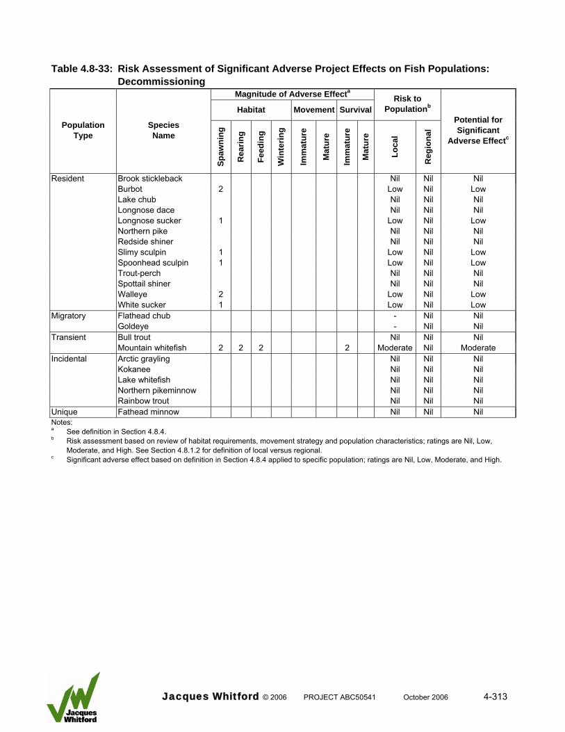
Table 4.8-33: Risk Assessment of Significant Adverse Project Effects on Fish Populations:
Decommissioning Magnitude of Adverse Effecta
Habitat Movement SurvivalRisk to
Populationb
Population Type
Species Name
Spaw
ning
Rea
ring
Feed
ing
Win
terin
g
Imm
atur
e
Mat
ure
Imm
atur
e
Mat
ure
Loca
l
Reg
iona
l
Potential for Significant
Adverse Effectc
Resident Brook stickleback Nil Nil Nil Burbot 2 Low Nil Low Lake chub Nil Nil Nil Longnose dace Nil Nil Nil Longnose sucker 1 Low Nil Low Northern pike Nil Nil Nil Redside shiner Nil Nil Nil Slimy sculpin 1 Low Nil Low Spoonhead sculpin 1 Low Nil Low Trout-perch Nil Nil Nil Spottail shiner Nil Nil Nil Walleye 2 Low Nil Low White sucker 1 Low Nil Low Migratory Flathead chub - Nil Nil Goldeye - Nil Nil Transient Bull trout Nil Nil Nil Mountain whitefish 2 2 2 2 Moderate Nil Moderate Incidental Arctic grayling Nil Nil Nil Kokanee Nil Nil Nil Lake whitefish Nil Nil Nil Northern pikeminnow Nil Nil Nil Rainbow trout Nil Nil Nil Unique Fathead minnow Nil Nil Nil Notes: a See definition in Section 4.8.4. b Risk assessment based on review of habitat requirements, movement strategy and population characteristics; ratings are Nil, Low,
Moderate, and High. See Section 4.8.1.2 for definition of local versus regional. c Significant adverse effect based on definition in Section 4.8.4 applied to specific population; ratings are Nil, Low, Moderate, and High.
Jacques Whitford © 2006 PROJECT ABC50541 October 2006 4-313
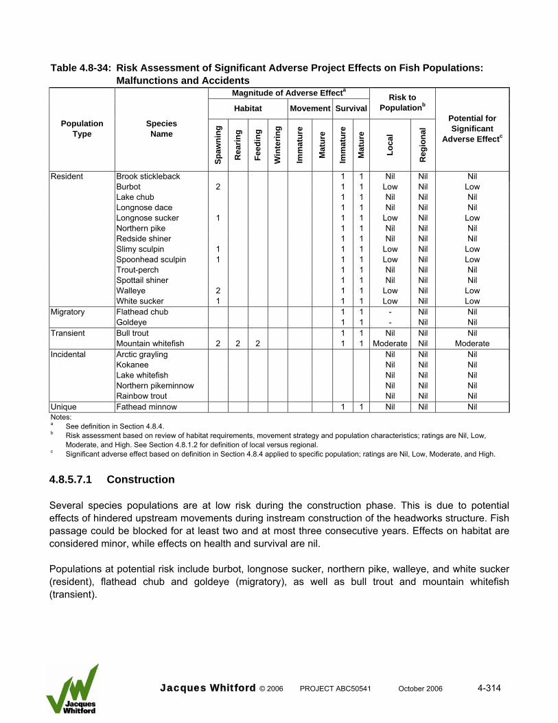
Table 4.8-34: Risk Assessment of Significant Adverse Project Effects on Fish Populations:
Malfunctions and Accidents Magnitude of Adverse Effecta
Habitat Movement SurvivalRisk to
Populationb
Population Type
Species Name
Spaw
ning
Rea
ring
Feed
ing
Win
terin
g
Imm
atur
e
Mat
ure
Imm
atur
e
Mat
ure
Loca
l
Reg
iona
l
Potential for Significant
Adverse Effectc
Resident Brook stickleback 1 1 Nil Nil Nil Burbot 2 1 1 Low Nil Low Lake chub 1 1 Nil Nil Nil Longnose dace 1 1 Nil Nil Nil Longnose sucker 1 1 1 Low Nil Low Northern pike 1 1 Nil Nil Nil Redside shiner 1 1 Nil Nil Nil Slimy sculpin 1 1 1 Low Nil Low Spoonhead sculpin 1 1 1 Low Nil Low Trout-perch 1 1 Nil Nil Nil Spottail shiner 1 1 Nil Nil Nil Walleye 2 1 1 Low Nil Low White sucker 1 1 1 Low Nil Low Migratory Flathead chub 1 1 - Nil Nil Goldeye 1 1 - Nil Nil Transient Bull trout 1 1 Nil Nil Nil Mountain whitefish 2 2 2 1 1 Moderate Nil Moderate Incidental Arctic grayling Nil Nil Nil Kokanee Nil Nil Nil Lake whitefish Nil Nil Nil Northern pikeminnow Nil Nil Nil Rainbow trout Nil Nil Nil Unique Fathead minnow 1 1 Nil Nil Nil Notes: a See definition in Section 4.8.4. b Risk assessment based on review of habitat requirements, movement strategy and population characteristics; ratings are Nil, Low,
Moderate, and High. See Section 4.8.1.2 for definition of local versus regional. c Significant adverse effect based on definition in Section 4.8.4 applied to specific population; ratings are Nil, Low, Moderate, and High.
4.8.5.7.1 Construction Several species populations are at low risk during the construction phase. This is due to potential effects of hindered upstream movements during instream construction of the headworks structure. Fish passage could be blocked for at least two and at most three consecutive years. Effects on habitat are considered minor, while effects on health and survival are nil. Populations at potential risk include burbot, longnose sucker, northern pike, walleye, and white sucker (resident), flathead chub and goldeye (migratory), as well as bull trout and mountain whitefish (transient).
Jacques Whitford © 2006 PROJECT ABC50541 October 2006 4-314
Because it is assumed that upstream passage by adults of the large-fish species can be mitigated the outcome of the risk assessment indicates that during project construction there is a low potential for a significant adverse effect on large-fish species considered at risk 4.8.5.7.2 Operations Several species populations would potentially be at risk during the operations phase from one or more factors. Analysis of habitat losses versus gains suggest that for the fish community as a whole, the changes in habitat caused by the Project would be positive. This includes the benthic habitat which would also include both losses and gains. This finding is not consistent among all fish species used for the losses versus gains calculations, because each has different habitat requirements. Species that require rock materials as a habitat component would be adversely affected by headpond formation. Populations most affected would include burbot, walleye, and mountain whitefish. Other species populations were given a low or nil magnitude rating because alternate areas are available or the requirement for rock materials as a habitat component is not essential. Large-fish species of note that may be positively affected by headpond formation include northern pike and goldeye (Mainstream 2006c). Project operations would hinder fish movements of some populations. Immature and mature classes of small sized-fish species and the immature class of large-sized fish species may not be able to move upstream due to the hydraulic characteristics of the fish passage facilities. In addition, upstream passage of burbot would be affected due to the timing of movement relative to passage structure operation. Downstream movement by all species would not be hindered. Project operations could affect the health and survival of all populations in the project area due to turbine passage. It is important to note that the magnitude of effect is low for most species for two reasons. First, survival rates would be high for small-sized species and immature fish of large-sized species. Second, the fish passage mitigation strategy would protect adults of most large fish-species. The only exceptions would be burbot, walleye, and mountain whitefish. For these three species the magnitude of effect on survival was considered moderate (burbot and walleye) or high (mountain whitefish) based on the conservative assumption that a substantial portion of the adult (mature) population could pass through the turbines. The risk to a particular population depends on the population boundary and population type. The risk to populations at the regional level is considered low because there are only minimal effects. This applies equally to all population types including migratory flathead chub and goldeye. At the local level some species populations are at higher risk because of combined effects on habitat, movement, and health and survival. Burbot and walleye resident populations are at moderate risk because spawning habitat and adult survival would be adversely affected by the Project. The transient mountain whitefish population is considered at high risk because several habitat types would be affected as would survival of adults during turbine passage. The outcome of the risk assessment indicates that during project operations there is a moderate potential for a significant adverse effect on local burbot and walleye populations and high potential for a significant adverse effect on the local mountain whitefish population. It should be acknowledged; however, that the local mountain whitefish population is transitory and is not self-sustaining in the
Jacques Whitford © 2006 PROJECT ABC50541 October 2006 4-315
project area, and the burbot and walleye populations immediately adjacent to the Project will be unaffected (see Section 4.8.7.1.4). 4.8.5.7.3 Decommissioning During the decommissioning phase the only adverse effect is related to alteration of downstream fish habitat due to dewatering of the headpond. This assumes that the decommissioning plan is designed to effectively manage sedimentation effects. The magnitude of effect is either low or moderate depending on the species population habitat requirements and distribution of available habitats. There is no risk to species populations at the regional level and only a low risk at the local level. The only species population expected to be at moderate risk is mountain whitefish. The outcome of the risk assessment indicates that during project decommissioning there is a moderate potential for a significant adverse effect on local mountain whitefish population. All other species have a low or nil potential for a significant adverse effect. 4.8.5.7.4 Malfunctions and Accidents Malfunctions and accidents, although unlikely to occur, have the potential to cause adverse effects to fish habitat (infrastructure failure and massive slope failure) and on fish health and survival (contaminants spill). The magnitude of these effects was considered low for most species. Exceptions included a moderate rating for burbot, walleye, and mountain whitefish habitat. The risk to all populations at the regional level was nil. At the local level only the mountain whitefish population was at moderate risk. The outcome of the risk assessment indicates that there is a moderate potential for a significant adverse effect on local mountain whitefish population due to malfunctions and accidents. All other species have a low or nil potential for a significant adverse effect. 4.8.5.7.5 Risk Assessment Conclusion The risk assessment evaluated the potential for a significant adverse effect of project activities on individual species populations during each project phase. The evaluation examined the magnitude of effect on habitat, movement, and health and survival based on species population requirements and rated risk at the local and regional level based on population type. The outcome of the risk assessment identified a number of species populations that have a low to moderate risk of a significant adverse effect. A summary is provided in Table 4.8-35. When project effects are viewed as a whole burbot and mountain whitefish populations have a high potential for a significant adverse effect at the local level, while walleye have a moderate potential for a significant adverse effect at the local level. All other species potentially affected by project activities received a low rating. There is a nil to low potential for the Project to cause a significant adverse effect at the regional level.
Jacques Whitford © 2006 PROJECT ABC50541 October 2006 4-316
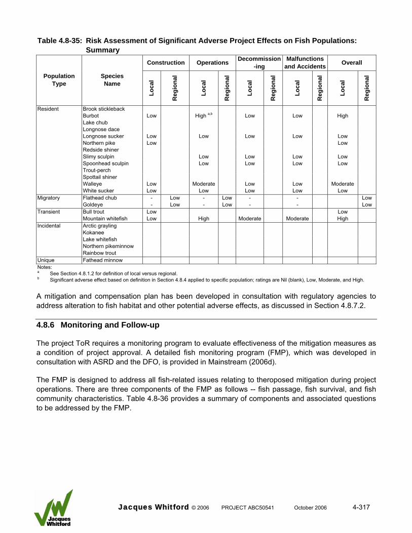
Table 4.8-35: Risk Assessment of Significant Adverse Project Effects on Fish Populations:
Summary
Construction Operations Decommission-ing
Malfunctions and Accidents Overall
Population Type
Species Name
Loca
l
Reg
iona
l
Loca
l
Reg
iona
l
Loca
l
Reg
iona
l
Loca
l
Reg
iona
l
Loca
l
Reg
iona
l
Resident Brook stickleback Burbot Low High a,b Low Low High Lake chub Longnose dace Longnose sucker Low Low Low Low Low Northern pike Low Low Redside shiner Slimy sculpin Low Low Low Low Spoonhead sculpin Low Low Low Low Trout-perch Spottail shiner Walleye Low Moderate Low Low Moderate White sucker Low Low Low Low Low Migratory Flathead chub - Low - Low - - Low Goldeye - Low - Low - - Low Transient Bull trout Low Low Mountain whitefish Low High Moderate Moderate High Incidental Arctic grayling Kokanee Lake whitefish Northern pikeminnow Rainbow trout Unique Fathead minnow Notes: a See Section 4.8.1.2 for definition of local versus regional. b Significant adverse effect based on definition in Section 4.8.4 applied to specific population; ratings are Nil (blank), Low, Moderate, and High.
A mitigation and compensation plan has been developed in consultation with regulatory agencies to address alteration to fish habitat and other potential adverse effects, as discussed in Section 4.8.7.2. 4.8.6 Monitoring and Follow-up The project ToR requires a monitoring program to evaluate effectiveness of the mitigation measures as a condition of project approval. A detailed fish monitoring program (FMP), which was developed in consultation with ASRD and the DFO, is provided in Mainstream (2006d). The FMP is designed to address all fish-related issues relating to theroposed mitigation during project operations. There are three components of the FMP as follows -- fish passage, fish survival, and fish community characteristics. Table 4.8-36 provides a summary of components and associated questions to be addressed by the FMP.
Jacques Whitford © 2006 PROJECT ABC50541 October 2006 4-317
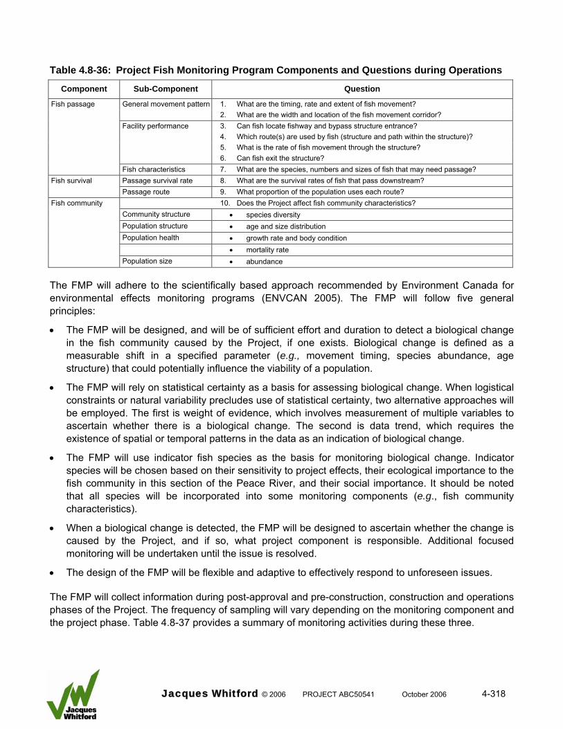
Table 4.8-36: Project Fish Monitoring Program Components and Questions during Operations
Component Sub-Component Question
Fish passage 1. What are the timing, rate and extent of fish movement?
General movement pattern 2. What are the width and location of the fish movement corridor?
3. Can fish locate fishway and bypass structure entrance? 4. Which route(s) are used by fish (structure and path within the structure)? 5. What is the rate of fish movement through the structure?
Facility performance
6. Can fish exit the structure? Fish characteristics 7. What are the species, numbers and sizes of fish that may need passage? Fish survival Passage survival rate 8. What are the survival rates of fish that pass downstream? Passage route 9. What proportion of the population uses each route? Fish community 10. Does the Project affect fish community characteristics? Community structure • species diversity Population structure • age and size distribution Population health • growth rate and body condition • mortality rate Population size • abundance
The FMP will adhere to the scientifically based approach recommended by Environment Canada for environmental effects monitoring programs (ENVCAN 2005). The FMP will follow five general principles:
• The FMP will be designed, and will be of sufficient effort and duration to detect a biological change in the fish community caused by the Project, if one exists. Biological change is defined as a measurable shift in a specified parameter (e.g., movement timing, species abundance, age structure) that could potentially influence the viability of a population.
• The FMP will rely on statistical certainty as a basis for assessing biological change. When logistical constraints or natural variability precludes use of statistical certainty, two alternative approaches will be employed. The first is weight of evidence, which involves measurement of multiple variables to ascertain whether there is a biological change. The second is data trend, which requires the existence of spatial or temporal patterns in the data as an indication of biological change.
• The FMP will use indicator fish species as the basis for monitoring biological change. Indicator species will be chosen based on their sensitivity to project effects, their ecological importance to the fish community in this section of the Peace River, and their social importance. It should be noted that all species will be incorporated into some monitoring components (e.g., fish community characteristics).
• When a biological change is detected, the FMP will be designed to ascertain whether the change is caused by the Project, and if so, what project component is responsible. Additional focused monitoring will be undertaken until the issue is resolved.
• The design of the FMP will be flexible and adaptive to effectively respond to unforeseen issues. The FMP will collect information during post-approval and pre-construction, construction and operations phases of the Project. The frequency of sampling will vary depending on the monitoring component and the project phase. Table 4.8-37 provides a summary of monitoring activities during these three.
Jacques Whitford © 2006 PROJECT ABC50541 October 2006 4-318
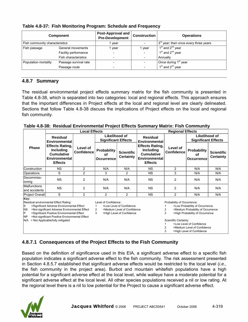
Table 4.8-37: Fish Monitoring Program: Schedule and Frequency
Component Post-Approval and Pre-Development Construction Operations
3rd year; then once every three years Fish community characteristics 1 year - 1st and 2nd year Fish passage General movements 1 year 1 year 1st and 2nd year Facility performance - -
Fish characteristics - - Annually Once during 1st year Passage survival rate - - Population mortality
Passage route - - 1st and 2nd year
4.8.7 Summary The residual environmental project effects summary matrix for the fish community is presented in Table 4.8-38, which is separated into two categories: local and regional effects. This approach ensures that the important differences in Project effects at the local and regional level are clearly delineated. Sections that follow Table 4.8-38 discuss the implications of Project effects on the local and regional fish community. Table 4.8-38: Residual Environmental Project Effects Summary Matrix: Fish Community
Local Effects Regional Effects Likelihood of
Significant Effects Likelihood of
Significant Effects
Phase
Residual Environmental Effects Rating,
Including Cumulative
Environmental Effects
Level of Confidence Probability
of Occurrence
Scientific Certainty
Residual Environmental Effects Rating,
Including Cumulative
Environmental Effects
Level of Confidence Probability
of Occurrence
Scientific Certainty
Construction NS 2 N/A N/A NS 2 N/A N/A Operations S 2 3 2 NS 3 N/A N/A Decommiss-ioning NS 2 N/A N/A NS 2 N/A N/A
Malfunctions and accidents NS 2 N/A N/A NS 2 N/A N/A
Project Overall S 2 2 2 NS 2 N/A N/A Key: Residual environmental Effect Rating: S =Significant Adverse Environmental Effect NS =Not significant Adverse Environmental Effect P =Significant Positive Environmental Effect NP =Not significant Positive Environmental Effect N/A = Not Applicable/fully mitigated
Level of Confidence: 1 =Low Level of Confidence 2 =Medium Level of Confidence 3 =High Level of Confidence
Probability of Occurrence: 1 =Low Probability of Occurrence 2 =Medium Probability of Occurrence 3 =High Probability of Occurrence Scientific Certainty: 1 =Low Level of Confidence 2 =Medium Level of Confidence 3 =High Level of Confidence
4.8.7.1 Consequences of the Project Effects to the Fish Community Based on the definition of significance used in this EIA, a significant adverse effect to a specific fish population indicates a significant adverse effect to the fish community. The risk assessment presented in Section 4.8.5.7 established that significant adverse effects would be restricted to the local level (i.e., the fish community in the project area). Burbot and mountain whitefish populations have a high potential for a significant adverse effect at the local level, while walleye have a moderate potential for a significant adverse effect at the local level. All other species populations received a nil or low rating. At the regional level there is a nil to low potential for the Project to cause a significant adverse effect.
Jacques Whitford © 2006 PROJECT ABC50541 October 2006 4-319
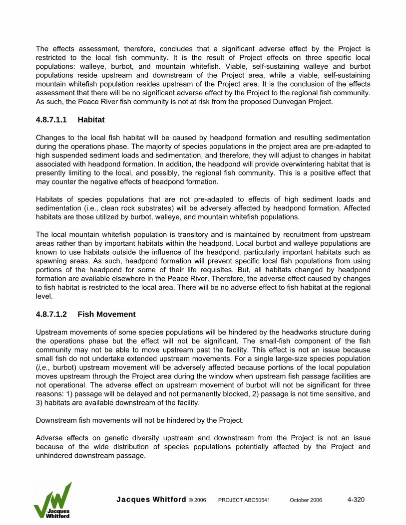
The effects assessment, therefore, concludes that a significant adverse effect by the Project is restricted to the local fish community. It is the result of Project effects on three specific local populations: walleye, burbot, and mountain whitefish. Viable, self-sustaining walleye and burbot populations reside upstream and downstream of the Project area, while a viable, self-sustaining mountain whitefish population resides upstream of the Project area. It is the conclusion of the effects assessment that there will be no significant adverse effect by the Project to the regional fish community. As such, the Peace River fish community is not at risk from the proposed Dunvegan Project. 4.8.7.1.1 Habitat Changes to the local fish habitat will be caused by headpond formation and resulting sedimentation during the operations phase. The majority of species populations in the project area are pre-adapted to high suspended sediment loads and sedimentation, and therefore, they will adjust to changes in habitat associated with headpond formation. In addition, the headpond will provide overwintering habitat that is presently limiting to the local, and possibly, the regional fish community. This is a positive effect that may counter the negative effects of headpond formation. Habitats of species populations that are not pre-adapted to effects of high sediment loads and sedimentation (i.e., clean rock substrates) will be adversely affected by headpond formation. Affected habitats are those utilized by burbot, walleye, and mountain whitefish populations. The local mountain whitefish population is transitory and is maintained by recruitment from upstream areas rather than by important habitats within the headpond. Local burbot and walleye populations are known to use habitats outside the influence of the headpond, particularly important habitats such as spawning areas. As such, headpond formation will prevent specific local fish populations from using portions of the headpond for some of their life requisites. But, all habitats changed by headpond formation are available elsewhere in the Peace River. Therefore, the adverse effect caused by changes to fish habitat is restricted to the local area. There will be no adverse effect to fish habitat at the regional level. 4.8.7.1.2 Fish Movement Upstream movements of some species populations will be hindered by the headworks structure during the operations phase but the effect will not be significant. The small-fish component of the fish community may not be able to move upstream past the facility. This effect is not an issue because small fish do not undertake extended upstream movements. For a single large-size species population (i,e., burbot) upstream movement will be adversely affected because portions of the local population moves upstream through the Project area during the window when upstream fish passage facilities are not operational. The adverse effect on upstream movement of burbot will not be significant for three reasons: 1) passage will be delayed and not permanently blocked, 2) passage is not time sensitive, and 3) habitats are available downstream of the facility. Downstream fish movements will not be hindered by the Project. Adverse effects on genetic diversity upstream and downstream from the Project is not an issue because of the wide distribution of species populations potentially affected by the Project and unhindered downstream passage.
Jacques Whitford © 2006 PROJECT ABC50541 October 2006 4-320
4.8.7.1.3 Fish Health and Survival The health and survival of local burbot, walleye, and mountain whitefish would be adversely affected by turbine passage during the operations phase. Turbine passage will occur when downstream fish passage facilities are not fully operational (i.e., when exclusion bars are not in place during winter). The consequences to these local populations and the local fish community depends on the portion of each population that require passage, and whether these fish are integral to the viability of each population. Movement data suggests that some, but not the entire local population of burbot and walleye pass the proposed project site. Because the portion of fish that will undertake turbine passage cannot be accurately quantified, the conservative approach of the evaluation dictates that this adverse effect be deemed significant. Local mountain whitefish originate from upstream populations and are likely dispersing through the project area; therefore, it is possible that a large segment of the local population would pass through the turbines. Because mountain whitefish are dispersing through the area the adverse effect on the fish community would be minimized by continued replacement of lost fish via recruitment from upstream sources. Despite the assumed significant adverse effect on health and survival of local burbot, walleye, and mountain whitefish populations, this project effect will not be an issue for regional fish populations or the regional fish community. 4.8.7.1.4 Configuration of the Post-development Fish Community The potential effects of the Project on the local fish community are complex and difficult to predict. One way to evaluate the effects is to identify other reaches of the Peace River that exhibit features that are expected to occur in the headpond and make comparisons to fish communities that exist in those reaches. One reach that resembles the proposed headpond, in terms of gradient, materials, ice conditions and water depth is the section near Carcajou (Hildebrand 1990, RL&L 1993, NHC 2006c, Miles 2000b). It exhibits a low gradient, is dominated by small-textured materials, contains water depths exceeding 6 m and is covered by a thermal ice sheet during winter. The fish community in the Carcajou reach of the Peace River is similar to the one that currently resides in the project area (Hildebrand 1990; RL&L 1993). Except for the absence of cold water species that require clean rock substrates (e.g., , mountain whitefish), species diversity is similar. Longnose sucker is the dominant large-fish species followed by much lower numbers of goldeye, walleye, northern pike and burbot. As for the project area, adults dominate the life stages of various fish species at Carcajou. The only notable difference is the presence of young-of-the-year goldeye, a life stage that is absent in the project area. Based on the assumption that the physical characteristics of the Carcajou site will be similar to those of the Project, it can be concluded that the fish community in the headpond will not change dramatically from what presently exists. 4.8.7.2 Mitigation and Compensation The environmental effects assessment of the Project on the Peace River has identified a number of adverse effects that could have significant effects on the fish community if not mitigated.
Jacques Whitford © 2006 PROJECT ABC50541 October 2006 4-321
Glacier Power is committed to the fullest extent possible to mitigate potential adverse effects of the Project. Mitigation measures have been discussed in each of the effects assessment sections. Each subsection of the Fish EIA provides descriptions of mitigation measures. Other documents that describe mitigation include: • Project Description (CPL 2006)
• Dunvegan Hydroelectric Project Fish Passage Rationale (NHC 2006b)
• Habitat No Net Loss Plan for the Dunvegan Hydroelectric Project (Mainstream 2006c)
• Fish Monitoring Plan for the Dunvegan Hydroelectric Project (Mainstream 2006d) 4.8.7.2.1 Fish Passage Glacier Power is committed to providing effective fish passage as an integral part of the Project. To achieve this goal Glacier Power has completed extensive work to maximize its understanding of movement requirements of fish populations potentially affected by the Project. Glacier Power has completed an extensive evaluation and modelling program to develop a fish passage strategy that will achieve its goal: to provide effective fish passage to ensure the long-term viability of fish populations. Modelling tested proposed fish passage structures in an adaptive management framework to arrive at the best practical solution with ideal hydraulics and highest efficiencies. Modelling was used to confirm the hydraulic design criteria and assumptions prior to the final design and construction of the facility. And, it was used to provide a high level of confidence for the regulators in the hydraulic performance of the structure with respect to fish passage requirements. Glacier Power has designed a fish passage operation strategy to maximize the effectiveness of fish passage structures while maintaining the operational integrity and economic viability of the Project. This work and decisions related to fish passage mitigation was carried out in close consultation with DFO and ASRD. 4.8.7.2.1.1 Fish Health and Survival Glacier Power acknowledges that fish health and survival could be affected by headworks operation. Mitigation includes two primary features. Firstly, fish-friendly turbines are used to maximize fish survival. Secondly, downstream fish passage facilities will be used in combination with exclusion trash racks to facilitate safe downstream passage. 4.8.7.2.1.2 Fish Habitat Headpond formation will result in changes to fish habitat. These include negative and positive effects. Full mitigation of headpond effects on fish habitat is not possible; however, Glacier Power has developed a fish habitat compensation package in consultation with DFO and ASRD. 4.8.7.2.1.3 Monitoring Glacier Power is committed to well-structured, scientifically defensible monitoring programs to assess the effectiveness of mitigation measures, and to inform any adaptive management that may be required. The proposed monitoring plan has been developed in consultation with DFO and ASRD (see Mainstream 2006d).
Jacques Whitford © 2006 PROJECT ABC50541 October 2006 4-322
