iucn world heritage evaluations 2017whc.unesco.org/archive/2017/whc17-41com-inf8b2-en.pdf · this...
TRANSCRIPT
:RUOG+HULWDJH&RQYHQWLRQ
8QLWHG�1DWLRQV(GXFDWLRQDO��6FLHQWL¿F�DQG
&XOWXUDO�2UJDQL]DWLRQ
��>693+
�/,90;(.,���7(;904
60
5,�465+0(3�
�
7(;9
046506�4<5+0(3
IUCN World Heritage Evaluations 2017IUCN Evaluations of nominations of natural and mixed properties to the World Heritage List
WHC/17/41.COM/INF.8B2
IUCN REPORT FOR THE WORLD HERITAGE COMMITTEE, 41ST SESSION, KRAKÓW, POLAND, 2-12 JULY 2017

Cover page photo: Los Alerces National Park, Argentina © IUCN/T. Jaeger 2016
IUCN Evaluations of Nominations of Natural and Mixed Properties to the World Heritage List
Table of Contents Executive summary table Alphabetical index and IUCN field evaluators Introduction A. Natural Properties Page n° A1. New Nominations of Natural Properties
Africa Benin/Burkina Faso – W-Arly-Pendjari Complex (extension of W – Niger) 3 Ghana – Mole National Park 17 Asia / Pacific China – Qinghai Hoh Xil 29 India – Bhitarkanika Conservation Area 43 Europe / North America Albania/Austria/Belgium/Bulgaria/Croatia/Italy/Romania/Slovenia/Spain/Ukraine –
Primeval Beech Forests of the Carpathians and Other Regions of Europe 55 Latin America / Caribbean Argentina – Los Alerces National Park 73
A2. Referred Nominations of Natural Properties
Asia / Pacific Mongolia/Russian Federation – Landscapes of Dauria See document WHC/17/41.COM/INF.8B2.ADD
A3. Minor Boundary Modifications of Natural Properties
Asia / Pacific India – Manas Wildlife Sanctuary See document WHC/17/41.COM/INF.8B2.ADD India – Western Ghats See document WHC/17/41.COM/INF.8B2.ADD
B. Mixed Properties Page n° B1. New Nominations of Mixed Properties
Latin America / Caribbean Mexico – Tehuacán-Cuicatlán Valley: originary habitat of Mesoamerica 89
B2. Minor Boundary Modifications of Mixed Properties Asia / Pacific China – Mount Wuyi See document WHC/17/41.COM/INF.8B2.ADD

C. Cultural Properties Page n° C1. New Nominations of Cultural Landscapes
Africa South Africa – ǂKhomani Cultural Landscape 103
Europe / North America Denmark – Kujataa – a subarctic farming landscape in Greenland 107 France – Taputapuātea 111 United Kingdom of Great Britain and Northern Ireland – The English Lake District 115
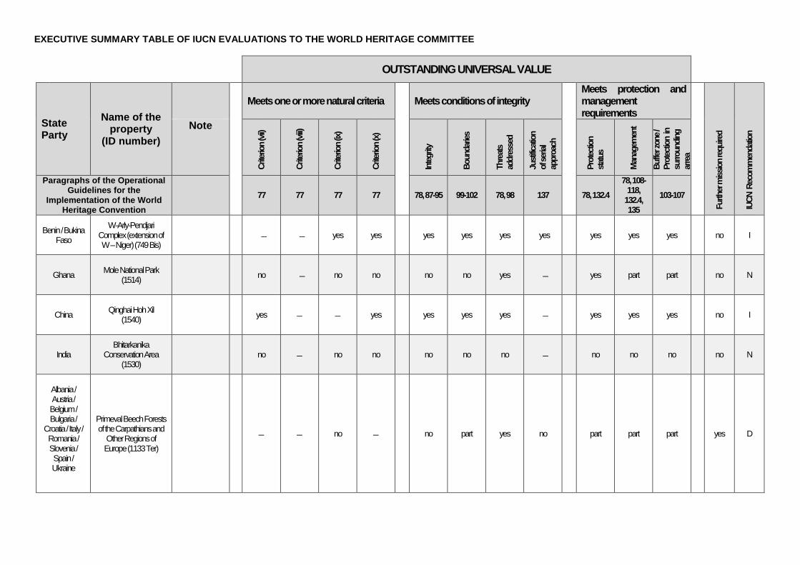
EXECUTIVE SUMMARY TABLE OF IUCN EVALUATIONS TO THE WORLD HERITAGE COMMITTEE
OUTSTANDING UNIVERSAL VALUE
State Party
Name of the property
(ID number)
Meets one or more natural criteria
Meets conditions of integrity
Meets protection and management requirements
Furth
er m
ission
requ
ired
IUCN
Rec
omm
enda
tion
Note
Crite
rion (
vii)
Crite
rion (
viii)
Crite
rion (
ix)
Crite
rion (
x)
Integ
rity
Boun
darie
s
Thre
ats
addr
esse
d
Justi
ficati
on
of se
rial
appr
oach
Prot
ectio
n sta
tus
Man
agem
ent
Buffe
r zon
e /
Prot
ectio
n in
surro
undin
g ar
rea
Paragraphs of the Operational Guidelines for the
Implementation of the World Heritage Convention
77 77 77 77
78, 87-95 99-102 78, 98 137
78, 132.4
78, 108-118,
132.4, 135
103-107
Benin / Bukina Faso
W-Arly-Pendjari Complex (extension of W – Niger) (749 Bis)
yes yes
yes yes yes yes
yes yes yes no I
Ghana Mole National Park (1514)
no no no
no no yes
yes part part no N
China Qinghai Hoh Xil (1540)
yes yes
yes yes yes
yes yes yes no I
India Bhitarkanika
Conservation Area (1530)
no no no
no no no
no no no no N
Albania / Austria / Belgium / Bulgaria /
Croatia / Italy / Romania / Slovenia / Spain / Ukraine
Primeval Beech Forests of the Carpathians and
Other Regions of Europe (1133 Ter)
no
no part yes no
part part part yes D
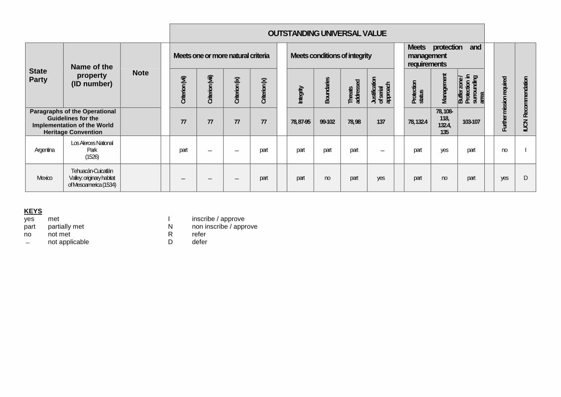
OUTSTANDING UNIVERSAL VALUE
State Party
Name of the property
(ID number)
Meets one or more natural criteria
Meets conditions of integrity
Meets protection and management requirements
Furth
er m
ission
requ
ired
IUCN
Rec
omm
enda
tion
Note
Crite
rion (
vii)
Crite
rion (
viii)
Crite
rion (
ix)
Crite
rion (
x)
Integ
rity
Boun
darie
s
Thre
ats
addr
esse
d
Justi
ficati
on
of se
rial
appr
oach
Prot
ectio
n sta
tus
Man
agem
ent
Buffe
r zon
e /
Prot
ectio
n in
surro
undin
g ar
rea
Paragraphs of the Operational Guidelines for the
Implementation of the World Heritage Convention
77 77 77 77
78, 87-95 99-102 78, 98 137
78, 132.4
78, 108-118,
132.4, 135
103-107
Argentina Los Alerces National
Park (1526)
part part
part part part
part yes part no I
Mexico Tehuacán-Cuicatlán
Valley: originary habitat of Mesoamerica (1534)
part
part no part yes
part no part yes D
KEYS yes met I inscribe / approve part partially met N non inscribe / approve no not met R refer not applicable D defer
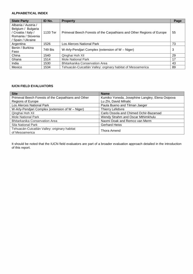
ALPHABETICAL INDEX State Party ID No. Property Page Albania / Austria / Belgium / Bulgaria / Croatia / Italy / Romania / Slovenia / Spain / Ukraine
1133 Ter Primeval Beech Forests of the Carpathians and Other Regions of Europe 55
Argentina 1526 Los Alerces National Park 73 Benin / Burkina Faso 749 Bis W-Arly-Pendjari Complex (extension of W – Niger) 3
China 1540 Qinghai Hoh Xil 29 Ghana 1514 Mole National Park 17 India 1530 Bhitarkanika Conservation Area 43 Mexico 1534 Tehuacán-Cuicatlán Valley: orginary habitat of Mesoamerica 89 IUCN FIELD EVALUATORS Site Name Primeval Beech Forests of the Carpathians and Other Regions of Europe
Kumiko Yoneda, Josephine Langley, Elena Osipova Lu Zhi, David Mihalic
Los Alerces National Park Paula Bueno and Tilman Jaeger W-Arly-Pendjari Complex (extension of W – Niger) Thierry Lefebvre Qinghai Hoh Xil Carlo Ossola and Chimed Ochir-Bazarsad Mole National Park Wendy Strahm and Oscar Mthimkhulu Bhitarkanika Conservation Area Naomi Doak and Remco van Merm Sila National Park Gerhard Heiss Tehuacán-Cuicatlán Valley: originary habitat of Mesoamerica Thora Amend
It should be noted that the IUCN field evaluators are part of a broader evaluation approach detailed in the introduction of this report.

THE WORLD HERITAGE CONVENTION IUCN TECHNICAL EVALUATION REPORT OF WORLD HERITAGE NOMINATIONS
MAY 2017
1. INTRODUCTION This technical evaluation report of natural and mixed properties nominated for inclusion on the World Heritage List has been conducted by the World Heritage Programme of IUCN (International Union for Conservation of Nature). The World Heritage Programme co-ordinates IUCN’s input to the World Heritage Convention in close cooperation with the IUCN Global Protected Areas Programme (GPAP) and other units of IUCN both at headquarters and in the regions. It also works particularly closely with IUCN’s World Commission on Protected Areas (WCPA), the world’s leading expert network of protected area managers and specialists, with the IUCN Species Survival Commission (SSC) and other IUCN Commissions, as well as the many members and partners of IUCN. IUCN’s evaluations are conducted according to the Operational Guidelines that the World Heritage Committee has agreed, and which are the essential framework for the application of the evaluation process. This framework was updated and revised in 2015, and a revised process documented in Annex 6 of the Operational Guidelines, following discussion by the World Heritage Committee. In carrying out its function under the World Heritage Convention, IUCN has been guided by four principles: (i) ensuring the highest standards of quality control,
institutional memory and consistency in relation to technical evaluation, monitoring and other associated activities;
(ii) increasing the use of specialist networks of IUCN,
especially WCPA, but also other relevant IUCN Commissions and specialist partner networks;
(iii) working in support of the UNESCO World
Heritage Centre and States Parties to examine how IUCN can creatively and effectively support the World Heritage Convention and individual properties as “flagships” for conservation; and
(iv) increasing the level of effective partnership
between IUCN and the World Heritage Centre, ICOMOS and ICCROM.
Members of the expert network of WCPA carry out the majority of technical evaluation missions, supported by other specialists where appropriate. The WCPA network now totals more than 1800 members, protected area managers and specialists from over 140 countries. In addition, the World Heritage Programme calls on relevant experts from IUCN’s
other five Commissions (Species Survival, Environmental Law, Education and Communication, Ecosystem Management, and Environmental, Economic and Social Policy); from international earth science unions, non-governmental organizations and scientific contacts in universities and other international agencies. This highlights the considerable “added value” from investing in the use of the extensive networks of IUCN and partner institutions. These networks allow for the increasing involvement of regional natural heritage experts and broaden the capacity of IUCN with regard to its work under the World Heritage Convention. Reports from field missions and comments from a large number of external reviewers are comprehensively examined by the IUCN World Heritage Panel, as key inputs to each evaluation. The IUCN World Heritage Programme prepares the final technical evaluation reports which are presented in this document and represent the corporate position of IUCN on World Heritage evaluations. IUCN has also placed emphasis on providing input and support to ICOMOS in relation to those cultural landscapes which have important natural values. IUCN has continued to extend its cooperation with ICOMOS, including coordination in relation to the evaluation of mixed sites and cultural landscapes. IUCN and ICOMOS have also enhanced the coordination of their panel processes as requested by the World Heritage Committee. This cooperation was reported at the 40th Session of the World Heritage Committee, and will be discussed under Item 9B this year, where IUCN and ICOMOS exchanged and coordinated their advice to the Committee, as also noted in the relevant specific reports. IUCN has endeavoured wherever possible to work in the spirit of the Upstream Process, as will be debated in the relevant items on the Committee’s agenda 2. EVALUATION PROCESS In carrying out the technical evaluation of nominations IUCN is guided by the Operational Guidelines to the World Heritage Convention, specifically Annex 6 which spells out the evaluation process. The evaluation process is carried out over the period of one year, from the receipt of nominations at IUCN in March and the submission of the IUCN evaluation report to the World Heritage Centre in May of the following year. The process involves the following steps:
IUCN Evaluation Report – May 2017 i
1. External Review. The nomination is sent to independent experts knowledgeable about the property or its natural values, including members of WCPA, other IUCN specialist Commissions and scientific networks or NGOs working in the region. IUCN received over 120 external reviews in relation to the properties examined in 2015 / 2016.
2. Field Mission. Missions involving one, or
wherever possible two or more IUCN experts, evaluate the nominated property on the ground and discuss the nomination with the relevant national and local authorities, local communities, NGOs and other stakeholders. Missions usually take place between July and October. In the case of mixed properties and certain cultural landscapes, missions are jointly implemented with ICOMOS.
3. IUCN World Heritage Panel Review. The Panel
intensively reviews the nomination dossiers, field mission reports, comments from external reviewers and other relevant reference material, and provides its technical advice to IUCN on recommendations for each nomination. A final report is prepared and forwarded to the World Heritage Centre in May for distribution to the members of the World Heritage Committee.
4. Comparative Analysis. IUCN commissions UN
Environment WCMC to carry out a global comparative analysis for all properties nominated under the biodiversity criteria (ix) and (x) to a standard and publicly available IUCN/WCMC methodology. Following inscription, datasheets are compiled with WCMC.
5. Communities. IUCN has enhanced its evaluation
processes through the implementation of a series of measures to evaluate stakeholder and rights holder engagement during the nomination process (see below for further details)
6. Final Recommendations. IUCN presents, with
the support of images and maps, the results and recommendations of its evaluation process to the World Heritage Committee at its annual session in June or July, and responds to any questions. The World Heritage Committee makes the final decision on whether or not to inscribe the property on the World Heritage List.
It should be noted that IUCN has increasingly sought, over many years, to develop and maintain a dialogue with the State Party throughout the evaluation process to allow the State Party every opportunity to supply all the necessary information and to clarify any questions or issues that may arise. IUCN is available to respond to questions at any time, however, there are three occasions on which IUCN may formally request further information from the State Party. These are: • Before the field mission. IUCN sends the State
Party, usually directly to the person organizing the mission in the host country, a briefing on the
mission, in many cases raising specific questions and issues that should be discussed during the mission. This allows the State Party to prepare properly in advance;
• Directly after the field mission. Based on
discussions during the field mission, IUCN may send an official letter requesting supplementary information before the IUCN World Heritage Panel meets in December, to ensure that the Panel has all the information necessary to make a recommendation on the nomination; and
• After the first meeting of the IUCN World
Heritage Panel (December). IUCN continues its practice of ongoing communication with the nominating State Party/ies following its Panel meeting. In line with changes to Annex 6 of the Operational Guidelines this communication now comprises an interim report to the Parties on the status of the evaluation, sent by the end of January. If the Panel finds some questions are still unanswered or further issues need to be clarified, this letter may request supplementary information by a specific deadline. That deadline must be adhered to strictly in order to allow IUCN to complete its evaluation. In view of the importance of the requests for supplementary information, IUCN seeks to complete those at least one month before the requested deadline of 31st January, and in the present cycle all nominations where the IUCN Panel had questions, these were sent before the end of December 2016. It should be noted that in a number of cases the Panel may not have additional questions, but nevertheless dialogue is invited in all cases. It is expected that supplementary information will be in response to specific questions or issues and should not include completely revised nominations or substantial amounts of new information. It should be emphasized that whilst exchanges between evaluators and the State Party during the mission may provide valuable feedback they do not substitute for the formal requests for supplementary information outlined above. In additional IUCN has continued to promote additional dialogue with States Parties on the conclusion of its panel process, to allow for discussion of issues that have been identified and to allow more time to prepare discussions at the World Heritage Committee. This has involved face to face meetings in Paris, and in IUCN’s offices in Switzerland, and conference calls via Skype or dial-in conferences.
In the technical evaluation of nominated properties, global biogeographic classification systems such as Udvardy’s biogeographic provinces, and the Terrestrial Ecoregion of the World (similarly, freshwater and marine ecoregions of the world in respective environments) are used to identify and assess comparable properties at the global level. These methods make comparisons of natural properties more objective and provide a practical means of assessing similarity and representation at the global level. At the
ii IUCN Evaluation Report – May 2017
same time, World Heritage properties are expected to contain special features, habitats and faunistic or floristic peculiarities that can also be compared on a broader biome basis. It is stressed that these systems are used as a basis for comparison only and do not imply that World Heritage properties are to be selected based on these systems alone. In addition, global conservation priority-setting schemes such as Key Biodiversity Areas (http://www.keybiodiversityareas.org/home), including Important Bird Areas, Alliance for Zero Extinction sites, and systems such as WWF’s Global 200 Priority Ecoregions, Conservation International’s Biodiversity Hotspots and High Biodiversity Wilderness Areas, Birdlife International’s Endemic Bird Areas, and IUCN/WWF Centres of Plant Diversity provide useful guidance. The decisive principle is that World Heritage properties are only those areas of Outstanding Universal Value. The evaluation process is also aided by the publication of a series of reference volumes and thematic studies. In early 2012 a resource manual on the preparation of World Heritage Nominations was published, under joint lead authorship of IUCN and ICOMOS, and has provided further details on best practices, including the key resources that are available to support nominations. IUCN’s range of thematic studies and key references that advise priorities on the World Heritage List are available at the following web address: https://www.iucn.org/theme/world-heritage/resources. IUCN members adopted a specific resolution on these matters at the IUCN World Conservation Congress in 2012, which remains current, and this resolution (WCC-2012-Res-047-EN Implementation of the United Nations Declaration on the Rights of Indigenous Peoples in the context of the UNESCO World Heritage Convention) is available at the following address: https://portals.iucn.org/congress/assembly/motions. IUCN has continued to implement a range of improved practices within its evaluation process in response to these reviews and reflections, which are focused on the inclusion of a specific section headed “Communities” within each evaluation report, to ensure transparency and consistency of IUCN’s advice to the World Heritage Committee on this important issue. These measures include a standard screening form for all evaluation missions, additional consultation with networks specialised in this field, and including an expert advisor in the membership of the IUCN World Heritage Panel. In 2013, IUCN updated its format for field evaluation reports, to include specific questions on communities, and to also clarify a range of questions and expectations of feedback from evaluators to ensure consistency of reports from field missions. This material is all publicly available and available at the following web address: https://www.iucn.org/theme/world-heritage/our-work/advisor-world-heritage/nominations. IUCN completed also in 2013 an evaluation of its World Heritage Programme, and a management response to its findings was agreed in 2014 and is
being implemented. Following this, and consistent with discussions held at the World Heritage Committee, the implementation of revised working methods of the IUCN World Heritage Panel is being implemented in 2016. The evaluation and the management response are available online at the following address: https://www.iucn.org/monitoring-and-evaluation/monitoring-our-work/evaluations-database. The implementation of reform on IUCN’s work on World Heritage is also integrating agreed actions arising from the work of the Ad-hoc Working Group of States Parties, which has enabled valuable dialogue between States Parties and the Advisory Bodies, and also enabled IUCN and ICOMOS to consider a range of potential options to harmonise further their evaluation processes. IUCN welcomes this dialogue and considers the work of the Ad-hoc group provides a good model for possible continued dialogue towards effective new procedures for the evaluation process. IUCN notes that reform of the evaluation process is constrained fundamentally by the current calendar, and that many of the expections of States Parties regarding increases in dialogue and transparency require more time to be provided for the evaluation, especially for nominations that are found to not meet requirements of the Operational Guidelines. In addition the implementation of the upstream process needs to be a central priority, and additional reflection on options, and additional resources will be required to enable it to be effective, equitable to States Parties, and appropriate in supporting a balanced and representative World Heritage List. 3. THE IUCN WORLD HERITAGE PANEL Purpose: The Panel advises IUCN on its work on World Heritage, particularly in relation to the evaluation of World Heritage nominations. The Panel normally meets face to face once a year for a week in December. Depending on the progress made with evaluations, and the requirement for follow up action, a second meeting or conference call in the following March may be required. Additionally, the Panel operates by email and/or conference call, as required. Functions: A core role of the Panel is to provide a technical peer review process for the consideration of nominations, leading to the formal adoption of advice to IUCN on the recommendations it should make to the World Heritage Committee. In doing this, the Panel critically examines each available nomination document, the field mission report, the UNEP-WCMC Comparative Analysis, comments from external reviewers and other material, and uses this to help prepare IUCN’s advice, including IUCN recommendations relating to inscription under specified criteria, to the World Heritage Committee (and, in the case of some cultural landscapes, advice to ICOMOS). It may also advise IUCN on other matters concerning World Heritage, including the State of Conservation of World Heritage properties and on policy matters relating to the Convention. Though it takes account of the policy context of IUCN’s work under the Convention, its primary role is to deliver
IUCN Evaluation Report – May 2017 iii
independent, high quality scientific and technical advice to IUCN, which has the final responsibility for corporate recommendations made to the World Heritage Committee. Panel members agree to a code of conduct which ensures ethical behaviour and avoids any conflict of interest. Membership: Membership of the Panel is at the invitation of the IUCN Director General (or Deputy Director General under delegated authority) through the Director of the World Heritage Programme. The members of the Panel comprise IUCN staff with responsibility for IUCN’s World Heritage work, other relevant IUCN staff, Commission members and external experts selected for their high level of experience with the World Heritage Convention. The membership of the Panel comprises: • The Director, IUCN World Heritage Programme
(Chair – non-voting) • At least one and a maximum of two staff of the
IUCN Global Protected Areas Programme • One Senior Advisor appointed by the IUCN
Director General or delegate to advise the organisation on World Heritage
• The IUCN World Commission on Protected Areas (WCPA) Vice Chair for World Heritage
• A representative of the IUCN Species Survival Commission (SSC) appointed on recommendation of the Chair, SSC
• The Head of the UNEP-WCMC Protected Areas Programme (this position is an ex-officio advisor to the Panel, without a vote).
• Up to seven technical advisors, invited by IUCN and serving in a personal capacity, with recognised leading expertise and knowledge relevant to IUCN’s work on World Heritage, including particular thematic and/or regional perspectives.
• As of 2017 one position for a specialist in geological heritage, appointed by IUCN following consultation with IUGS and the UNESCO Earth Sciences will be introduced.
In the course of 2016, and as previously agreed following the recommendation of the Committee’s ad-hoc working group, IUCN has introduced a fixed term for Panel members (four years renewable once) and an internal application process, open to IUCN Commission members and IUCN members, to fill vacancies for technical advisors when they arise. The first appointments to the Panel made following this process were made in the present nomination cycle. The Panel’s preparations and its meetings are facilitated through the work of the World Heritage Evaluations and Operations Officer. Information on the members of the IUCN World Heritage Panel, together with its Terms of Reference and the formats for IUCN documentation related to the evaluation process is posted online at the following link: https://www.iucn.org/theme/world-heritage/our-work/advisor-world-heritage/iucn-world-heritage-panel. A senior manager in IUCN (currently the IUCN Global Director, Biodiversity Conservation) is delegated by the
Director General to provide oversight at senior level on World Heritage, including with the responsibility to ensure that the Panel functions within its TOR and mandate. This senior manager is not a member of the Panel, but is briefed during the Panel meeting on the Panel’s conclusions. The Panel may also be attended by other IUCN staff, Commission members (including the WCPA Chair) and external experts for specific items at the invitation of the Chair. 4. EVALUATION REPORTS Each technical evaluation report presents a concise summary of the nominated property, a comparison with other similar properties, a review of management and integrity issues and concludes with the assessment of the applicability of the criteria and a clear recommendation to the World Heritage Committee. IUCN also submits separately to the World Heritage Centre its recommendation in the form of a draft decision, and a draft Statement of Outstanding Universal Value for all properties it recommends for inscription. Inaddition, IUCN carries out field missions and/or external reviews for cultural landscapes containing important natural values, and provides its comments to ICOMOS. This report contains a short summary of these comments on each cultural landscape nomination reviewed. 5. NOMINATIONS EXAMINED IN 2016 / 2017 Nomination dossiers and minor boundary modifications examined by IUCN in the 2016 / 2017 cycle included: • 7 natural property nominations (including 6 new
nominations and 1 extension); 1 nomination was withdrawn by the State Party after IUCN’s interim report;
• 1 mixed property nomination, where a joint mission was undertaken with ICOMOS;
• 4 cultural landscape nominations (all new nominations); IUCN accompanied ICOMOS on 1 field mission given the high natural values of the site, and 3 were commented on by IUCN based on internal and external desktop reviews;
• 1 referred nomination; • 3 minor boundary modifications. 6. COLLABORATION WITH INTERNATIONAL EARTH SCIENCE UNIONS IUCN implements its consideration of earth science values within the World Heritage Convention through a global theme study on Geological Heritage published in 2005. In addition collaboration agreements with the International Union of Geological Sciences (IUGS) and the International Association of Geomorphologists (IAG) focus on strengthening the evaluation process by providing access to the global networks of earth scientists coordinated through IUGS and IAG. IUCN would like to record its gratitude to IUGS and IAG for their willingness to provide support for its advisory role to the World Heritage Convention.
iv IUCN Evaluation Report – May 2017
7. RECOMMENDATIONS TO THE WORLD HERITAGE COMMITTEE In the 2016 / 2017 cycle, IUCN has sought to ensure that States Parties have the opportunity to provide all the necessary information on their nominated properties through the process outlined in section 2 above. As per the provisions of the Operatioal Guidelines, and Decision 30 COM 13 of the World Heritage Committee (Vilnius, 2006), IUCN has not taken into consideration or included any information submitted by States Parties after 28 February 2017, as evidenced by the postmark. IUCN has previously noted a number of points for improvement in the evaluation process, and especially to clarify the timelines involved. 8. ACKNOWLEDGEMENTS As in previous years, this report is a group product to which a large number of people have contributed. Acknowledgements for advice received are due to the external evaluators and reviewers, many of them from IUCN’s members, Commissions and Networks, and numerous IUCN staff at Headquarters and in IUCN’s Regional and Country Offices. Many others contributed inputs during field missions. This support is acknowledged with deep gratitude.
IUCN Evaluation Report – May 2017 v
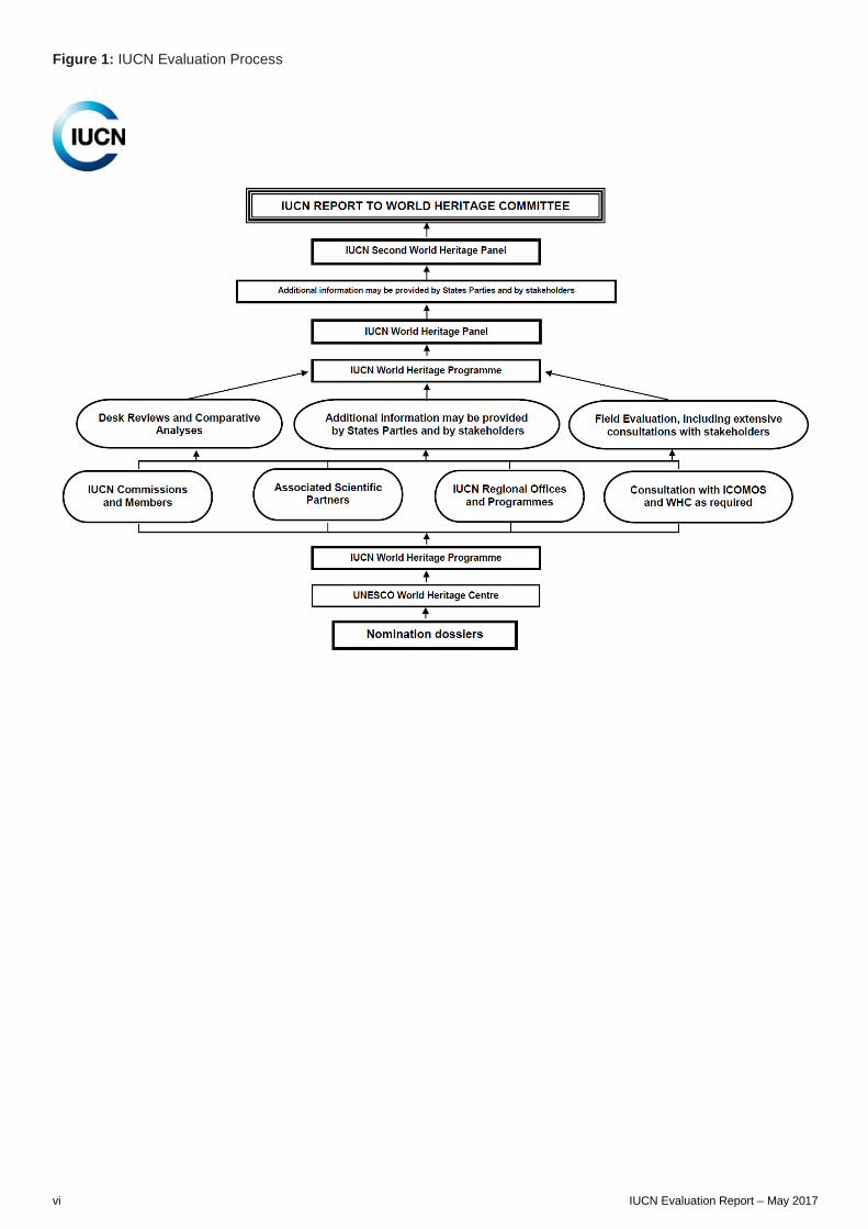
Figure 1: IUCN Evaluation Process
vi IUCN Evaluation Report – May 2017
A. NATURAL PROPERTIES A1. NEW NOMINATIONS OF NATURAL PROPERTIES

AFRICA
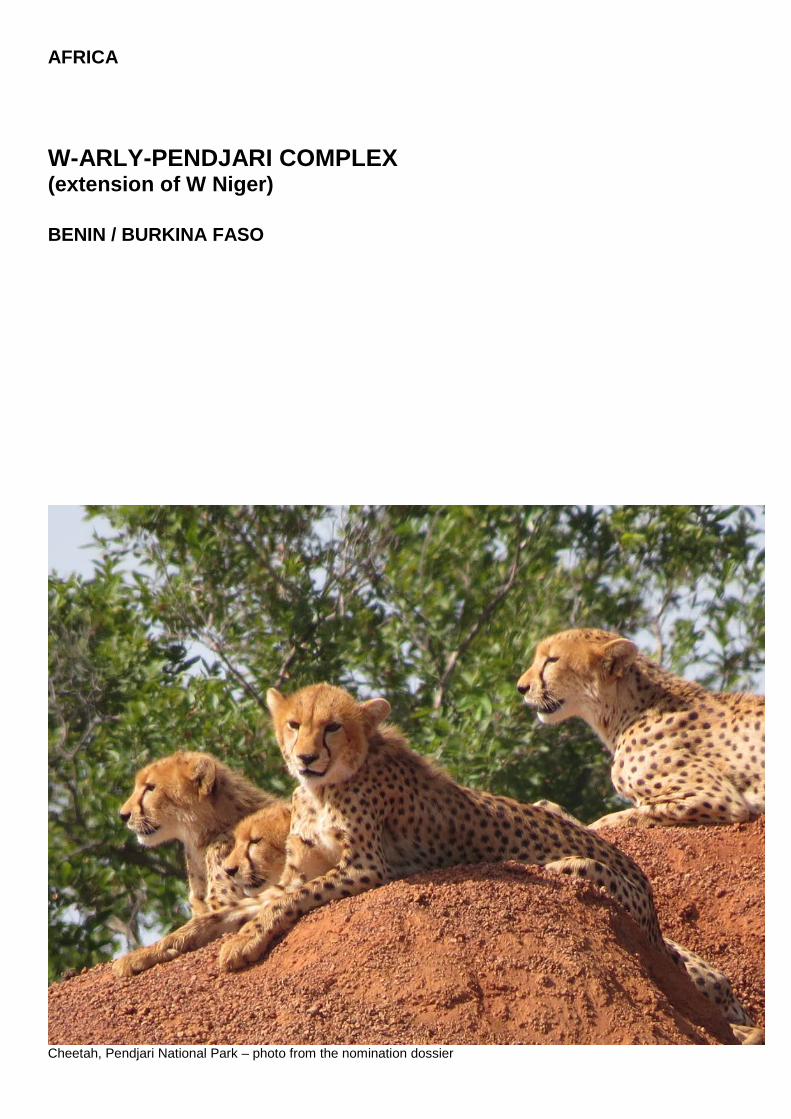
W-ARLY-PENDJARI COMPLEX (extension of W Niger) BENIN / BURKINA FASO
Cheetah, Pendjari National Park – photo from the nomination dossier

Benin / Burkina Faso – W-Arly-Pendjari Complex
WORLD HERITAGE NOMINATION – IUCN TECHNICAL EVALUATION
W-ARLY-PENDJARI COMPLEX (BENIN / BURKINA FASO) – ID N° 749 Bis
IUCN RECOMMENDATION TO WORLD HERITAGE COMMITTEE: To inscribe the property under natural criteria. Key paragraphs of Operational Guidelines: Paragraph 77: Nominated property meets World Heritage criteria. Paragraph 78: Nominated property meets integrity, protection and management requirements. Background note: The W-Arly-Pendjari Complex (WAP) is nominated under criteria (ix) and (x) as an extension of W National Park of Niger (WNP-Niger). WNP-Niger was inscribed on the World Heritage list under then natural criteria N(ii) and N(iv), now considered equivalent to criteria (ix) and (x). In its report to the World Heritage Committee, IUCN, at the time, had concluded that the nominated property in only Niger did not have Outstanding Universal Value as its characteristics were commonly found throughout the region and surpassed in importance in existing nearby World Heritage sites. Following a lengthy debate the Committee inscribed WNP-Niger in the World Heritage list through a majority vote at its 20th session in 1996 (Decision CONF 201 VIII.A). Since the addition of WNP-Niger onto the list in 1996 there have been a series of nominations, IUCN evaluations and Committee decisions related to this trinational complex of protected areas. In 2002, the State Party of Benin presented a joint nomination of Pendjari National Park (Pendjari NP) and W National Park of Benin (WNP-Benin) under criteria (vii) and (x). In its report to the 26th session of the World Heritage Committee, IUCN concluded that the site did not meet these criteria. The Committee referred the site back to the State Party to confirm that it considered this nomination as an extension of the WNP-Niger and to seek the approval of the Niger authorities for such an extension. Burkina Faso intended in 2009 to nominate Arly National Park (Arly NP) and Singou Wildlife Reserve with adjacent hunting reserves as a third extension of the WNP-Niger. The Committee encouraged the three concerned States Parties to coordinate across the entire trinational complex to configure one natural World Heritage property. In 2010, the State Party of Benin submitted a nomination of only Pendjari NP as an extension of WNP-Niger under only criteria (x). Following IUCN’s recommendation, the Committee deferred the examination of the nomination and recommended that Benin resubmit the property as an extension of WNP-Niger under identical criteria to the existing inscribed property, namely natural criteria (ix) and (x) (Decision 35 COM 8B.5). State of Conservation reporting on WNP-Niger has also, in the past, called for collaboration in finalizing proposals to extend the property in Niger into a transboundary property between the three countries (for example Decision 29COM 7B.3 of 2005). 1. DOCUMENTATION a) Date nomination received by IUCN: 24 March 2016 b) Additional information officially requested from and provided by the States Parties: Following the IUCN World Heritage Panel, a progress report was sent to the States Parties on 20 December 2016. This letter advised on the status of the evaluation process and sought responses/clarifications on a range of issues including the resource condition and management regime in the corridor areas between the two component areas of the proposed serial extension (the Pendjari and Arly NPs complex in the southwest and the WNPs complex in the northeast). The corridors were excluded from the originally nominated area due to a perceived incompatibility between hunting and World Heritage status. Additional information was therefore sought on the management and sustainability of hunting in these proposed buffer zones and the views of the States Parties on the possible inclusion of these corridors within the
nominated area to improve protection and connectivity. In addition, the States Parties were requested to confirm if there are additional national level buffer zones in place and their function; to provide more detail on the implementation of anti-poaching measures; and to provide more information on the management of fire in the nominated property. Specific additional information was sought from Burkina Faso on traditional transhumance patterns, their impact and management. The information in response was received from the States Parties on 7 February 2017. c) Additional literature consulted: IUCN’s previous evaluations of properties within the WAP Complex have generated good reference material which was reviewed. Various sources consulted in this evaluation including: MacKinnon, J. and MacKinnon K. (1986) Review of the protected areas system in the Afrotropical Realm Scoring system. UNEP/IUCN Rue Mauverney 28, Gland Switzerland 1196 (275pp). Bouché, P., Lungren, C.G., Hien, B. and Omondi, P. (2004) Aerial total count of the “W”-Arly-Pendjari-Oti-Mandouri-Keran (WAPOK) ecosystem in West Africa:
IUCN Evaluation Report – May 2017 5
Benin / Burkina Faso – W-Arly-Pendjari Complex
April-May 2003. Final Report February 2004. MIKE, EU, ECOPAS, PAUCOF and AFD. Ouagadougou, Burkina Faso. Clerici, N., Bodini, A., Eva, H., Gregoire, J. M., Dulieu, D. and Paolini, C. (2007). Increased isolation of two Biosphere Reserves and surrounding protected areas (WAP ecological complex, West Africa). Journal for Nature Conservation 15, 26-40. Djossa, B.A., Fahr, J., Kalko, E.V. and Sinsin, B. (2007) Importance of protected area in biodiversity conservation in Benin: Case Study of Bat. African Bat Conservation News 14, 6. Nago, S.G.A., Grell, O., Sinsin, B. and Rödel, M.-O. (2006) The amphibian fauna of Pendjari National Park and surroundings, northern Benin. Salamandra 42 (2/3), 93-108. Sinsin, B., Tehou, A. C., Daouda, I. and Saidou, A. (2009). Abundance and species richness of larger mammals in Pendjari National Park in Benin. Mammalia 66 (3), 369-380. Thiollay, J.M. (2007) Raptor declines in West Africa: comparisons between protected, buffer and cultivated areas. Oryx 41, 322-329. UNDP/GEF (2005) Enhancing the effectiveness and catalyzing the sustainability of the W-Arly-Pendjari (WAP) protected area system. UNDP Project Document. UNDP Project Document PIMS 1617. Available at: http://gefonline.org/projectDetailsSQL.cfm?projID=1197 Colyn M., Hulselman J., Sonet G., Oude P., Winter J., Natta A., Nagy Z., Verheyen E. 2010. Discovery of a new duiker species (Bovidae: Cephalophinae) from the Dahomey Gap, West Africa. Zootaxa 2637 : 1–30. DOI : http://dx.doi.org/10.11646/zootaxa.2637.1.1 Bouché P, Douglas-Hamilton I, Wittemyer G, Nianogo AJ, Doucet J-L, Lejeune P, et al. (2011). Will Elephants Soon Disappear from West African Savannahs? PLoS ONE 6(6): e20619. doi:10.1371/journal.pone.0020619. Chase MJ, Schlossberg S, Griffin CR, Bouché PJC, Djene SW, Elkan PW, Ferreira S, Grossman F, Kohi EM, Landen K, Omondi P, Peltier A, Selier SAJ, Sutcliffe R. (2016). Continent-wide survey reveals massive decline in African savannah elephants. PeerJ4:e2354 https://doi.org/10.7717/peerj.2354. Sinsin B., Saïdou A., Tehou A., Daouda I.H. et Nobime G., 2000: Dénombrement de la faune sauvage dans la Réserve de Biosphère de la Pendjari (Rapport technique). CENAGREF, Cotonou, Bénin, 58 p. Sokpon N., Biaou H., Hounhyet O., Ouisavi C. et Barbier N., 2001: Inventaire et caractérisation des formations végétales du complexe Réserve de Biosphère de la Pendjari, zones cynégétiques de la Pendjari et de l’Atacora (région de Konkombri), CENAGREF, Cotonou, Bénin. Sinsin B., Tehou A., Assogbadjo A., Sogbohossou E., Mama A., Gbangboche A., Yorou S. et Toko I., 2001:a). Fondation des savanes oust-africaines (FSOA), Un mécanisme sous-régional de financement durable de la conservation de la biodiversité. http://fsoa-conservationtrustfund.org/. Accessed 26 February 2017. d) Consultations: 13 desk reviews received. The mission met with representatives and staff of various authorities concerned in Burkina Faso and Benin including regional organizations such as the Economic Community of West African States (Union Economique et Monétaire Ouest Africaine - UEMOA), authorities concerned with the management of national parks and
hunting zones - the National Office of Protected Areas in Burkina Faso (Office National des Parcs et Réserves - OFINAP) and the National Centre for the Management of Wildlife Reserves in Benin (Centre National de Gestion des Réserves de Faune - CENAGREF). The mission also met with representatives of scientific organizations such as the National Centre for Scientific and Technical Research (CNRST), NGOs, technical staff from Gesellschaft für Internationale Zusammenarbeit (GIZ), the Programme d’Appui aux Parcs de l’Entente (PAPE) project, local authorities and village associations such as the Association Villageoise de Gestion des Réserves de Faune (AVIGREF). Representatives from WNP-Niger were met; however, the site was not visited during the mission. e) Field Visit: Thierry Lefebvre, 16 - 26 October 2016 f) Date of IUCN approval of this report: April 2017 2. SUMMARY OF NATURAL VALUES The W-Arly-Pendjari Complex (WAP Complex) is located in West Africa and, with the inclusion of the W National Park of Niger, spans the borders of all three countries: The Republic of Niger, Burkina Faso and the Republic of Benin. The nominated property is a transnational (Benin, Burkina Faso) extension to WNP-Niger inscribed in 1996. As originally nominated, the property was configured as a transnational serial extension to WNP-Niger partitioned in two component parts and comprising four protected areas (WNP-Benin and Pendjari NP both in Benin and WNP-Burkina Faso and Arly NP both in Burkina Faso). The States Parties in their supplementary information of January 2017 have advised a reconfigured nomination which adds four additional protected areas (hunting zones) to the nominated area thus creating a contiguous extension to the existing WNP-Niger. Two “zones cynégétiques” (Konkombri and Mékrou) in Benin which were previously within the proposed buffer zone have been added to the nominated area. In Burkina Faso two “zones villageoises d'intérêt cynégétique” (ZOVIC) have similarly been added to the nominated area from the previous buffer zone: Koakrana and Kourtiagou ZOVICs. As a consequence, the total extension area nominated is now 1,494,831 ha and a reconfigured buffer zone of 1,101,221 ha surrounds these areas within Benin and Burkina Faso. Table 1 shows the amended configuration and areas of the nominated extension to WNP-Niger. The nominated property is submitted based on the same two criteria as the existing WNP-Niger [criteria (ix) and (x)] and IUCN has evaluated the property as reconfigured. The State Party of Niger has provided a letter of support to the nomination and the proposed change of name should the extension be approved. Niger noted it has been engaged with Benin and Burkina Faso since 2000 on conservation and management of the Complex, and indicated in the letter that all three States Parties share the strong wish for the property to be an extension to WNP-Niger.
6 IUCN Evaluation Report – May 2017
Benin / Burkina Faso – W-Arly-Pendjari Complex
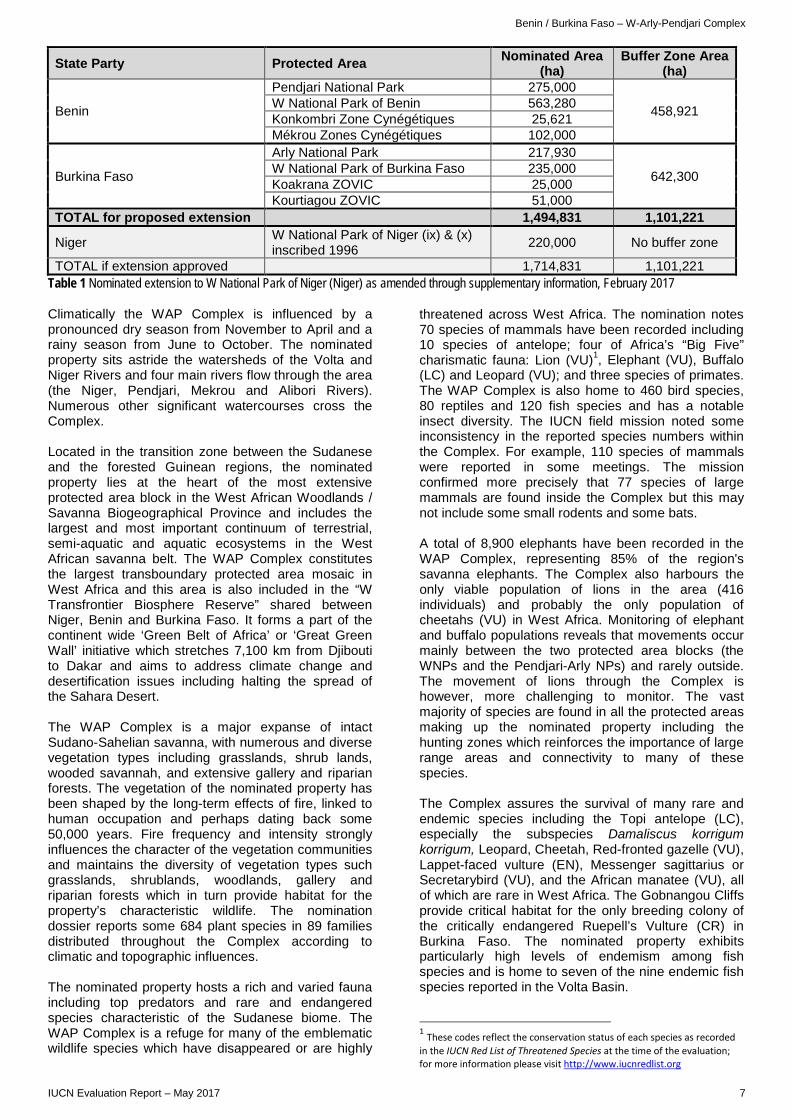
State Party Protected Area Nominated Area (ha)
Buffer Zone Area (ha)
Benin
Pendjari National Park 275,000
458,921 W National Park of Benin 563,280 Konkombri Zone Cynégétiques 25,621 Mékrou Zones Cynégétiques 102,000
Burkina Faso
Arly National Park 217,930
642,300 W National Park of Burkina Faso 235,000 Koakrana ZOVIC 25,000 Kourtiagou ZOVIC 51,000
TOTAL for proposed extension 1,494,831 1,101,221
Niger W National Park of Niger (ix) & (x) inscribed 1996 220,000 No buffer zone
TOTAL if extension approved 1,714,831 1,101,221 Table 1 Nominated extension to W National Park of Niger (Niger) as amended through supplementary information, February 2017 Climatically the WAP Complex is influenced by a pronounced dry season from November to April and a rainy season from June to October. The nominated property sits astride the watersheds of the Volta and Niger Rivers and four main rivers flow through the area (the Niger, Pendjari, Mekrou and Alibori Rivers). Numerous other significant watercourses cross the Complex. Located in the transition zone between the Sudanese and the forested Guinean regions, the nominated property lies at the heart of the most extensive protected area block in the West African Woodlands / Savanna Biogeographical Province and includes the largest and most important continuum of terrestrial, semi-aquatic and aquatic ecosystems in the West African savanna belt. The WAP Complex constitutes the largest transboundary protected area mosaic in West Africa and this area is also included in the “W Transfrontier Biosphere Reserve” shared between Niger, Benin and Burkina Faso. It forms a part of the continent wide ‘Green Belt of Africa’ or ‘Great Green Wall’ initiative which stretches 7,100 km from Djibouti to Dakar and aims to address climate change and desertification issues including halting the spread of the Sahara Desert. The WAP Complex is a major expanse of intact Sudano-Sahelian savanna, with numerous and diverse vegetation types including grasslands, shrub lands, wooded savannah, and extensive gallery and riparian forests. The vegetation of the nominated property has been shaped by the long-term effects of fire, linked to human occupation and perhaps dating back some 50,000 years. Fire frequency and intensity strongly influences the character of the vegetation communities and maintains the diversity of vegetation types such grasslands, shrublands, woodlands, gallery and riparian forests which in turn provide habitat for the property’s characteristic wildlife. The nomination dossier reports some 684 plant species in 89 families distributed throughout the Complex according to climatic and topographic influences. The nominated property hosts a rich and varied fauna including top predators and rare and endangered species characteristic of the Sudanese biome. The WAP Complex is a refuge for many of the emblematic wildlife species which have disappeared or are highly
threatened across West Africa. The nomination notes 70 species of mammals have been recorded including 10 species of antelope; four of Africa’s “Big Five” charismatic fauna: Lion (VU)1, Elephant (VU), Buffalo (LC) and Leopard (VU); and three species of primates. The WAP Complex is also home to 460 bird species, 80 reptiles and 120 fish species and has a notable insect diversity. The IUCN field mission noted some inconsistency in the reported species numbers within the Complex. For example, 110 species of mammals were reported in some meetings. The mission confirmed more precisely that 77 species of large mammals are found inside the Complex but this may not include some small rodents and some bats. A total of 8,900 elephants have been recorded in the WAP Complex, representing 85% of the region's savanna elephants. The Complex also harbours the only viable population of lions in the area (416 individuals) and probably the only population of cheetahs (VU) in West Africa. Monitoring of elephant and buffalo populations reveals that movements occur mainly between the two protected area blocks (the WNPs and the Pendjari-Arly NPs) and rarely outside. The movement of lions through the Complex is however, more challenging to monitor. The vast majority of species are found in all the protected areas making up the nominated property including the hunting zones which reinforces the importance of large range areas and connectivity to many of these species. The Complex assures the survival of many rare and endemic species including the Topi antelope (LC), especially the subspecies Damaliscus korrigum korrigum, Leopard, Cheetah, Red-fronted gazelle (VU), Lappet-faced vulture (EN), Messenger sagittarius or Secretarybird (VU), and the African manatee (VU), all of which are rare in West Africa. The Gobnangou Cliffs provide critical habitat for the only breeding colony of the critically endangered Ruepell’s Vulture (CR) in Burkina Faso. The nominated property exhibits particularly high levels of endemism among fish species and is home to seven of the nine endemic fish species reported in the Volta Basin.
1 These codes reflect the conservation status of each species as recorded in the IUCN Red List of Threatened Species at the time of the evaluation; for more information please visit http://www.iucnredlist.org
IUCN Evaluation Report – May 2017 7
Benin / Burkina Faso – W-Arly-Pendjari Complex
The nominated property is uninhabited as is the case with all national parks and hunting reserves in Benin and Burkina Faso. However, traces of prehistoric settlements can be found in the Complex (mounds, ceramics, evidence of iron metallurgy). The prehistoric migration of populations from the area was probably caused by disease epidemics and/or climate change. The few inhabitants who remained in the area were relocated by the colonial authorities from 1926 to 1954, to establish a park refuge and then the national park of zone W in 1954. At the time of their creation, the national parks were in a good state of conservation due to low levels of human impact and there remains little legacy of past land use. There are however three transhumance corridors, ancient seasonal grazing routes, affecting the nominated property: in the west, a corridor runs across Arly NP, while the other two cross the buffer zone to the west and east of the complex of WNPs in the northeast. 3. COMPARISONS WITH OTHER AREAS The nomination is a proposed extension to the WNP-Niger. IUCN notes that the nominated property therefore must make a case as to how it adds attributes of Outstanding Universal Value to the existing property and/or how it significantly improves integrity and/or protection and management effectiveness. As noted above, there have been various previous nominations of proposed extensions to the WNP-Niger which have emanated from within this complex of protected areas. Several past IUCN evaluations (1996, 2002, 2011) have variously assessed the comparative natural values of component parts of the complex. The comparative analysis within the nomination dossier is relatively brief. The WAP Complex is compared to six World Heritage properties inscribed in the Tropical and Subtropical Grasslands, Savannas, and Shrubland biome. Comparisons have been made on habitat specificities and species diversity against the Manovo-Gounda St Floris National Park (Central African Republic), the Comoé National Park (Ivory Coast), the Niokolo-Koba National Park (Senegal), the Mount Nimba Strict Nature Reserve (Guinea, Ivory Coast), the Sangha Trinational site (Cameroon, Central African Republic, Congo) and the Serengeti National Park (Tanzania). Apart from one site in Chad noted below, no other comparable Tentative Listed sites have been considered. The nomination dossier mixes values and attributes between both biodiversity criteria (ix) and (x). In addition, the global comparative analysis is mainly focused on criterion (x) attributes, and the viability of faunal populations is not well analyzed. The nomination references a 1986 IUCN study which reviewed the protected area system in the Afrotropical Realm. This study used a scoring system to assess the relative contribution to conservation of various protected areas in West Africa. The scoring system is based on a combination of size, protection objectives and management effectiveness. The dossier revisits this analysis and compares the WAP Complex against
five other protected areas in the same biogeographic province, four existing World Heritage sites and one Tentative Listed site: Zakouma National Park in Chad. In this analysis, the WAP Complex scores highest and has the second largest area of the compared sites. The analysis also concludes that the WAP Complex has the best level of conservation of the sites. Although this study is now over 30 years old and uses a methodology that has been superseded by more sophisticated data sets and analytic tools, IUCN considers that the findings remain valid. The WAP Complex persists as one of the best protected large-scale systems in West Africa. The nominated property’s contribution to conservation within the Region has likely, in fact, to have increased given the progressive loss of habitat and increasing pressure on the emblematic wildlife of West Africa over the past 30 years. Expert reviewers generally support this premise observing that the WAP ecosystem represents a jewel in West Africa. Whilst pointing out that there are comparatively very few endemic species, the area hosts the last viable or most viable populations for several species in West Africa. For example, when considering species such as cheetah, the subspecies Acinonyx jubatus hecki found in West and North Africa is different from the one found in other parts of Africa and is consequently critically endangered. The only viable population of this species in West Africa is in the WAP ecosystem. The situation is similar for the lion where the subspecies in West and Central Africa is different from the one in other parts of Africa. Additional spatial analysis by IUCN and WCMC notes seven other World Heritage properties occur within Udvardy’s West African Woodland Savanna Province, six of which are listed for biodiversity values. In addition, 16 natural Tentative Listed sites are found in the same Province, nine of these on the basis of their biodiversity values. 19 other biodiversity World Heritage sites and more than 65 Tentative Listed sites occur within the larger Afrotropic - Tropical and Subtropical Grasslands, Savannas, and Shrublands Terrestrial realm/biome combination. It is clear that the WAP Complex lies within biogeographic contexts which are well-represented on the World Heritage List and with a large number of potential new nominations in same biogepgraphy. This analysis also reveals the nominated property does not overlap with any broad scale global conservation priority systems but does correspond to three Important Bird Areas (Arly - W - Singou Complex; W du Bénin NP; and Pendjari NP). The key question relates to what additional values and integrity improvements the proposed extension adds to WNP-Niger. In overall terms the species composition across the WAP Complex is similar, however notwithstanding some variability in data, additional numbers of species are added through the extension (potentially 184 additional plant species, at least seven additional mammal species and 93 additional bird species, although the data is not very clear). The integration of Arly and Pendjari NPs also adds substantially to the habitat diversity, for example the addition of gallery forest ecosystems and a rare semi-deciduous Bondjagou/Pendjari forest. The numbers and density of rare and endangered species is
8 IUCN Evaluation Report – May 2017

Benin / Burkina Faso – W-Arly-Pendjari Complex
reportedly higher in Arly and Pendjari NPs than in the WNPs cluster, and the addition of the hunting reserves, which also contain similar natural values, ensures vital connectivity for these species. The IUCN/WCMC comparative analysis undertaken in 2011 in support of the evaluation of Pendjari NP as an extension to WNP-Niger stated on criterion (x) that "In conclusion, Pendjari NP’s inscription would add significant biodiversity values to the existing World Heritage property (WNP-Niger).” This is consistent with IUCN’s 1996 evaluation of WNP-Niger in which IUCN noted that “WNP-Niger on its own was only of national significance, whereas a transnational site with Benin and Burkina Faso would be of regional significance." On criterion (ix) the values were considered less distinctive from other World Heritage sites in the same Udvardy biogeographic province but WCMC concluded it would assist the balance and integrity of the WNP-Niger. In summary, many of the species occurring within the WAP Complex are also included within other existing World Heritage properties in the same biogeographic context. However, many of these sites are under severe threat and a disproportionate percentage is on the World Heritage in Danger List (50% of the biodiversity sites in the Udvardy West African Woodland/Savanna Province). One can conclude from this that the value of the WAP Complex rests on its size, intactness and viability as a refuge for a range of biodiversity and ecosystems which were formerly found across wider areas of the West African Region. IUCN in past evaluations has concluded that the various protected areas which comprise the WAP Complex have been unable to demonstrate Outstanding Universal Value in their own right, but as a large mosaic of protection, the Complex offers a globally significant refuge for these emblematic species. The nominated property as an extension to WNP-Niger adds attributes of Outstanding Universal Value hence strengthening the range and diversity of values that occur within WNP-Niger. The reconfigured and now contiguous nominated property extends the area of WNP-Niger by more than sevenfold appreciably improving the integrity of the overall complex and creating a system with greatly enhanced ecological connectivity and resilience. 4. INTEGRITY, PROTECTION AND MANAGEMENT 4.1. Protection Four of the protected areas within the nominated extension are national parks (Pendjari NP, Arly NP, WNP-Benin and WNP-Burkina Faso) considered to be IUCN Protected Area Management Category II. Protected areas which permit controlled hunting - called “zones cynégétiques” in Benin and “zones villageoises d'intérêt cynégétique” (ZOVIC) in Burkina Faso - surround the national parks and in some cases form parts of the World Heritage buffer zone. Four hunting zones have been included within the nominated area: Konkombri and Mékrou Zones Cynégétiques in Benin and Koakrana and Kourtiagou
ZOVICs in Burkina Faso. A range of relevant laws and decrees constitutes the legislative basis of protection across all protected areas in the Complex and is considered adequate in each country. The States Parties in supplementary information have reconfirmed that the hunting zones enjoy the same legal protection as national parks, the only difference being that sustainable hunting is permitted under strict control. IUCN considers the hunting zones are equivalent to IUCN Category VI. The Pendjari NP and the WNPs are also jointly recognized as biosphere reserves, which enable co-management with the surrounding populations. In 2007, a tripartite agreement for the management of the cross-border reserve was signed between Benin, Burkina Faso and Niger. The mission observed during the field visit that these various legal protections are effectively implemented and applied. The protected areas within the Complex are also subject to numerous national policies, strategies and plans. The area of the WAP Complex has a long history of protection having been designated since colonial times as a refuge zone in 1926. Both Benin and Burkina Faso have established protected areas progressively since the 1950s increasing protection through the various legal instruments referred to above. All land in the four national parks is publicly owned (it is the case across all three concerned States Parties). There is also no private ownership within hunting zones and this activity is managed under concessions. Public authorities manage the nominated property: in Benin by the Centre National de Gestion des Réserves de Faune (CENAGREF) and in Burkina Faso, Arly NP is managed by the Office National des Parcs et Réserves (OFINAP) and WNP-Burkina Faso by the State forestry administration: Direction Générale des Forêts et de la Faune (DGFF). At local level, people are aware of the boundaries of national parks and hunting zones. The national parks are not subject to any traditional resource use. Illegal use of land (anarchic cultivation, presence of pastoralists) is declining thanks to the development of peripheral pastoral areas, control and awareness. The States Parties have provided additional information on the management of the hunting zones indicating a system of quotas set each year and carefully monitored. Data has been provided indicating that these quotas from 2014-2016 have not been exceeded (or indeed reached) for any species over the past three years. The sport hunting concessions provide local people with employment and access to benefits. IUCN considers that the activity appears to be ecologically sustainable and therefore consistent with the potential Outstanding Universal Value of the area in accordance with Paragraph 90 of the Operational Guidelines. IUCN believes that the protection levels inside the WAP Complex, including the hunting zones, is adequate to protect the Outstanding Universal Value and therefore considers the protection status of the
IUCN Evaluation Report – May 2017 9
Benin / Burkina Faso – W-Arly-Pendjari Complex
nominated extended property meets the requirements of the Operational Guidelines. 4.2 Boundaries Boundaries are specified in the nomination and clearly demarcated on maps. As noted the States Parties have proposed amended boundaries to include within the nominated area four hunting zones which were previously within the World Heritage buffer zone proposed in the nomination. These hunting zones provide a functional link between the Complex elements and contain additional habitats for wildlife species. They also host savanna ecosystems and wildlife densities equivalent to those within the national parks. In its Decision 35 COM 8B.5 related to the nomination of the Pendjari NP, the World Heritage Committee recommended to the State Party of Benin to “confirm that there are effective means to provide connectivity and buffer zones between the Pendjari National Park and W National Park of Niger, and to consider identifying relevant hunting zones and other protected areas as either part of the nomination, or as buffer zones to a serial property”. IUCN welcomes the inclusion of these linking lands within the nominated area as they greatly improve the connectivity and wholeness of the proposed extension. These areas perform a much more central ecological and watershed function for wide ranging wildlife than that of a buffer zone and are thus considered an important contributory element to the Outstanding Universal Value of the WAP Complex. In addition, the supplementary information confirms that the State Parties wish to present a reconfigured World Heritage buffer zone that would add connecting areas, creating a buffer zone that now surrounds the proposed extension. The States Parties have also confirmed that national regulations already define a buffer zone around the boundaries of all national parks, varying in width from 5 to 7 km depending on the country, and so the additional areas correspond to areas that already exist and are functioning. The IUCN mission, however, reported some concerns about implementation and enforcement of national buffer zone regulations which seems to be variable. The locations of the buffer zone are explained in the supplementary information, although it will be important that the States Parties submit further maps to the World Heritage Centre to indicate the precise boundaries and areas of the buffer zones adjacent to the central portion of the property. Much of the perimeter of the resulting nominated property coincides with that of national parks, whose boundaries were defined in the 1950s in some cases. Whilst these boundaries are broadly known to the local populations, the management regime within the World Heritage buffer zone should be explicit as far as prohibited and permissible activities and development. IUCN notes that with this reconfiguration of the proposed WAP Complex, the only protected area lacking a buffer zone will become the WNP-Niger.
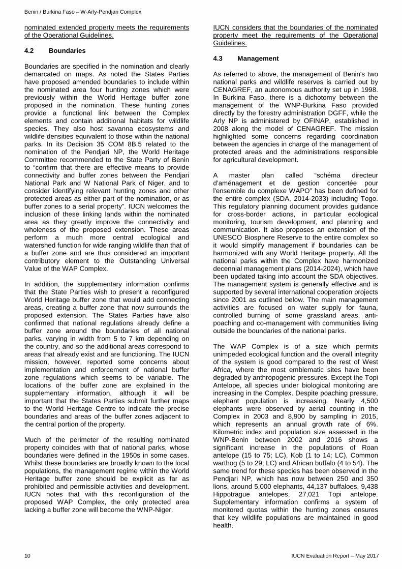
IUCN considers that the boundaries of the nominated property meet the requirements of the Operational Guidelines. 4.3 Management As referred to above, the management of Benin's two national parks and wildlife reserves is carried out by CENAGREF, an autonomous authority set up in 1998. In Burkina Faso, there is a dichotomy between the management of the WNP-Burkina Faso provided directly by the forestry administration DGFF, while the Arly NP is administered by OFINAP, established in 2008 along the model of CENAGREF. The mission highlighted some concerns regarding coordination between the agencies in charge of the management of protected areas and the administrations responsible for agricultural development. A master plan called “schéma directeur d’aménagement et de gestion concertée pour l'ensemble du complexe WAPO” has been defined for the entire complex (SDA, 2014-2033) including Togo. This regulatory planning document provides guidance for cross-border actions, in particular ecological monitoring, tourism development, and planning and communication. It also proposes an extension of the UNESCO Biosphere Reserve to the entire complex so it would simplify management if boundaries can be harmonized with any World Heritage property. All the national parks within the Complex have harmonized decennial management plans (2014-2024), which have been updated taking into account the SDA objectives. The management system is generally effective and is supported by several international cooperation projects since 2001 as outlined below. The main management activities are focused on water supply for fauna, controlled burning of some grassland areas, anti-poaching and co-management with communities living outside the boundaries of the national parks. The WAP Complex is of a size which permits unimpeded ecological function and the overall integrity of the system is good compared to the rest of West Africa, where the most emblematic sites have been degraded by anthropogenic pressures. Except the Topi Antelope, all species under biological monitoring are increasing in the Complex. Despite poaching pressure, elephant population is increasing. Nearly 4,500 elephants were observed by aerial counting in the Complex in 2003 and 8,900 by sampling in 2015, which represents an annual growth rate of 6%. Kilometric index and population size assessed in the WNP-Benin between 2002 and 2016 shows a significant increase in the populations of Roan antelope (15 to 75; LC), Kob (1 to 14; LC), Common warthog (5 to 29; LC) and African buffalo (4 to 54). The same trend for these species has been observed in the Pendjari NP, which has now between 250 and 350 lions, around 5,000 elephants, 44,137 buffaloes, 9,438 Hippotrague antelopes, 27,021 Topi antelope. Supplementary information confirms a system of monitored quotas within the hunting zones ensures that key wildlife populations are maintained in good health.
10 IUCN Evaluation Report – May 2017
Benin / Burkina Faso – W-Arly-Pendjari Complex
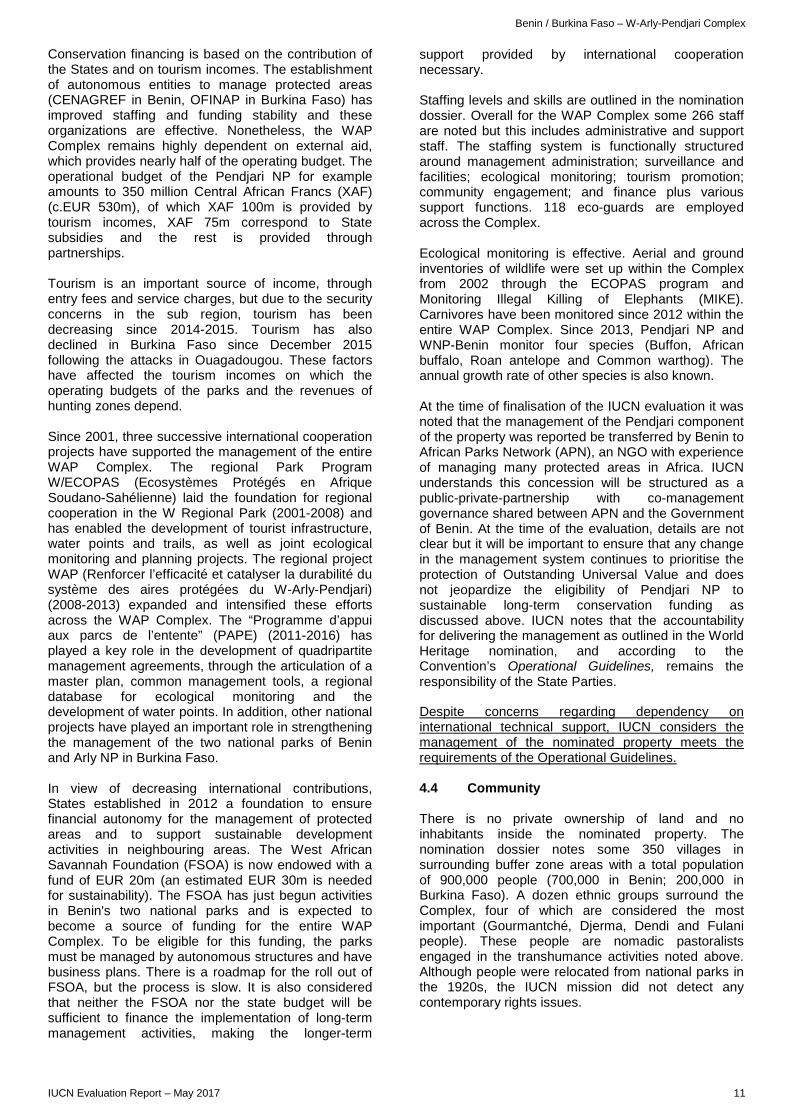
Conservation financing is based on the contribution of the States and on tourism incomes. The establishment of autonomous entities to manage protected areas (CENAGREF in Benin, OFINAP in Burkina Faso) has improved staffing and funding stability and these organizations are effective. Nonetheless, the WAP Complex remains highly dependent on external aid, which provides nearly half of the operating budget. The operational budget of the Pendjari NP for example amounts to 350 million Central African Francs (XAF) (c.EUR 530m), of which XAF 100m is provided by tourism incomes, XAF 75m correspond to State subsidies and the rest is provided through partnerships. Tourism is an important source of income, through entry fees and service charges, but due to the security concerns in the sub region, tourism has been decreasing since 2014-2015. Tourism has also declined in Burkina Faso since December 2015 following the attacks in Ouagadougou. These factors have affected the tourism incomes on which the operating budgets of the parks and the revenues of hunting zones depend. Since 2001, three successive international cooperation projects have supported the management of the entire WAP Complex. The regional Park Program W/ECOPAS (Ecosystèmes Protégés en Afrique Soudano-Sahélienne) laid the foundation for regional cooperation in the W Regional Park (2001-2008) and has enabled the development of tourist infrastructure, water points and trails, as well as joint ecological monitoring and planning projects. The regional project WAP (Renforcer l’efficacité et catalyser la durabilité du système des aires protégées du W-Arly-Pendjari) (2008-2013) expanded and intensified these efforts across the WAP Complex. The “Programme d’appui aux parcs de l’entente” (PAPE) (2011-2016) has played a key role in the development of quadripartite management agreements, through the articulation of a master plan, common management tools, a regional database for ecological monitoring and the development of water points. In addition, other national projects have played an important role in strengthening the management of the two national parks of Benin and Arly NP in Burkina Faso. In view of decreasing international contributions, States established in 2012 a foundation to ensure financial autonomy for the management of protected areas and to support sustainable development activities in neighbouring areas. The West African Savannah Foundation (FSOA) is now endowed with a fund of EUR 20m (an estimated EUR 30m is needed for sustainability). The FSOA has just begun activities in Benin's two national parks and is expected to become a source of funding for the entire WAP Complex. To be eligible for this funding, the parks must be managed by autonomous structures and have business plans. There is a roadmap for the roll out of FSOA, but the process is slow. It is also considered that neither the FSOA nor the state budget will be sufficient to finance the implementation of long-term management activities, making the longer-term
support provided by international cooperation necessary. Staffing levels and skills are outlined in the nomination dossier. Overall for the WAP Complex some 266 staff are noted but this includes administrative and support staff. The staffing system is functionally structured around management administration; surveillance and facilities; ecological monitoring; tourism promotion; community engagement; and finance plus various support functions. 118 eco-guards are employed across the Complex. Ecological monitoring is effective. Aerial and ground inventories of wildlife were set up within the Complex from 2002 through the ECOPAS program and Monitoring Illegal Killing of Elephants (MIKE). Carnivores have been monitored since 2012 within the entire WAP Complex. Since 2013, Pendjari NP and WNP-Benin monitor four species (Buffon, African buffalo, Roan antelope and Common warthog). The annual growth rate of other species is also known. At the time of finalisation of the IUCN evaluation it was noted that the management of the Pendjari component of the property was reported be transferred by Benin to African Parks Network (APN), an NGO with experience of managing many protected areas in Africa. IUCN understands this concession will be structured as a public-private-partnership with co-management governance shared between APN and the Government of Benin. At the time of the evaluation, details are not clear but it will be important to ensure that any change in the management system continues to prioritise the protection of Outstanding Universal Value and does not jeopardize the eligibility of Pendjari NP to sustainable long-term conservation funding as discussed above. IUCN notes that the accountability for delivering the management as outlined in the World Heritage nomination, and according to the Convention’s Operational Guidelines, remains the responsibility of the State Parties. Despite concerns regarding dependency on international technical support, IUCN considers the management of the nominated property meets the requirements of the Operational Guidelines. 4.4 Community There is no private ownership of land and no inhabitants inside the nominated property. The nomination dossier notes some 350 villages in surrounding buffer zone areas with a total population of 900,000 people (700,000 in Benin; 200,000 in Burkina Faso). A dozen ethnic groups surround the Complex, four of which are considered the most important (Gourmantché, Djerma, Dendi and Fulani people). These people are nomadic pastoralists engaged in the transhumance activities noted above. Although people were relocated from national parks in the 1920s, the IUCN mission did not detect any contemporary rights issues.
IUCN Evaluation Report – May 2017 11
Benin / Burkina Faso – W-Arly-Pendjari Complex
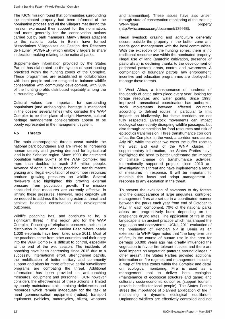
The IUCN mission found that communities surrounding the nominated property had been informed of the nomination process and all the villagers met during the mission expressed their support for the nomination, and more generally for the conservation actions carried out by park managers. Many villages adjacent to the national parks in Benin have formed “Associations Villageoises de Gestion des Réserves de Faune” (AVIGREF) which enable villagers to share in decision-making relating to the national parks. Supplementary information provided by the States Parties has elaborated on the system of sport hunting practiced within the hunting zones of the Complex. These programmes are established in collaboration with local people and are designed to balance wildlife conservation with community development, with 30% of the hunting profits distributed equitably among the surrounding villages. Cultural values are important for surrounding populations (and archeological heritage is mentioned in the dossier several times) who consider the WAP Complex to be their place of origin. However, cultural heritage management considerations appear to be poorly represented in the management system. 4.5 Threats The main anthropogenic threats occur outside the national park boundaries and are linked to increasing human density and growing demand for agricultural land in the Sahelian region. Since 1990, the estimated population within 30kms of the WAP Complex has more than doubled to reach 3.5 million people. Advance of agricultural front, poaching, transhumance grazing and illegal exploitation of non-timber resources produce growing pressures on wildlife. Several reviewers also highlighted this growing external pressure from population growth. The mission concluded that measures are currently effective in limiting these pressures. However, more capacity will be needed to address this looming external threat and achieve balanced conservation and development outcomes. Wildlife poaching has, and continues to be, a significant threat in this region and for the WAP Complex. Poaching of elephants concerns their entire distribution in Benin and Burkina Faso where nearly 1,000 elephants have been killed since 2011. Most of the poachers come from other countries and their entry into the WAP Complex is difficult to control, especially at the end of the wet season. The incidents of poaching have been decreasing since 2015 due to a successful international effort. Strengthened patrols, the mobilization of better military and community support and plans for more effective aerial surveillance programs are combating the threat. Additional information has been provided on anti-poaching measures, equipment and personnel. IUCN however considers the effectiveness of these actions is limited by poorly maintained trails, training deficiencies and resources which remain inadequate for the task at hand [communication equipment (radios), transport equipment (vehicles, motorcycles, bikes), weapons
and ammunition]. These issues have also arisen through state of conservation monitoring of the existing WNP-Niger property (http://whc.unesco.org/document/139968). Illegal livestock grazing and agriculture generally occurs outside the property in the buffer zone and needs good management with the local communities. With the exception of the hunting zones, there is no traditional resource use within the nominated property. Illegal use of land (anarchic cultivation, presence of pastoralists) is declining thanks to the development of peripheral pastoral areas, control and awareness. A combination of boundary patrols, law enforcement, incentive and education programmes are deployed to manage these threats. In West Africa, a transhumance of hundreds of thousands of cattle takes place every year, looking for forage resources and water points. Since 1998, improved transnational coordination has authorized stock movements between affected countries according to defined routes, in particular to limit impacts on biodiversity, but these corridors are not fully respected. Livestock movements can impact ecological connectivity disrupting wildlife passages, but also through competition for food resources and risk of epizootics transmission. Three transhumance corridors affect the Complex: in the west, a corridor runs across Arly NP, while the other two cross the buffer zone to the west and east of the WNP cluster. In supplementary information, the States Parties have highlighted the need to better understand the impacts of climate change on transhumance activities. Internationally supported projects since 2013 are investigating this threat and have implemented a range of measures in response. It will be important to maintain this focus and adapt management in response to any escalation in the threat. To prevent the evolution of savannas to dry forests and the disappearance of large ungulates, controlled management fires are set up in a coordinated manner between the parks each year from end of October to May. In each component, 70% of the national parks areas are progressively burnt depending on the grasslands drying rates. The application of fire in this landscape is an ancient practice which has shaped the vegetation and ecosystems. IUCN’s 2011 evaluation of the nomination of Pendjari NP in Benin as an extension to WNP-Niger noted that “the long-term use of fire, in the course of human use in the area for perhaps 50,000 years ago has greatly influenced the vegetation to favour fire tolerant species and there are local impacts on vegetation patterns around villages in other areas”. The States Parties provided additional information on fire regimes and management including a map of fire free zones within the Complex and detail on ecological monitoring. Fire is used as a management tool to deliver both ecological (maintenance of ecological structure and game) and cultural / socio-economic outcomes (support tourism, provide benefits for local people). The States Parties stress the importance of planned application of fire in maintaining a dynamic ecological equilibrium. Unplanned wildfires are effectively controlled and not
12 IUCN Evaluation Report – May 2017
Benin / Burkina Faso – W-Arly-Pendjari Complex
considered a significant threat to the property probably in part due to the controlled burning programme. The semi-arid Sahelian context is particularly sensitive to the effects of climate change. Increasing droughts can have negative impacts on fauna and floristic populations by sandblasting water points (some ponds dry out as early as December). However, hydric stress is not a limiting factor insofar adaptive responses exist through solar powered boreholes, which come into action at the end of the rainy season. The close links between climate, fire behavior and impact need to be better researched to understand these dynamics and adapt if necessary traditional burning regimes. In summary, the nominated extension substantially adds to the integrity of the inscribed property (WNP-Niger) by increasing the size more than sevenfold (779%) and adding several important attributes of Outstanding Universal Value. The inclusion of the interconnecting hunting zones between the two clusters of national parks creates a contiguous property further strengthening the overall property’s coherence. In contrast to many other protected areas within this region, the WAP Complex remains in good condition and does not suffer from the adverse effects of poaching and other impacts. The Complex is well managed with workable coordination mechanisms between its different parts although improvements could be made. Ongoing attention to buffer zone management issues is warranted. IUCN considers that the integrity, protection and management of the nominated extension meet the requirements of the Operational Guidelines. 5. ADDITIONAL COMMENTS Transboundary collaboration remains essential to effective management and coordination across the mosaic of protected areas, managing institutions and the three concerned States Parties. There has been a history of cooperation dating from the first anti-poaching agreement signed in 1984 between Benin and Burkina Faso and extended to Niger in 1986. Coordination efforts also focused on the management of transhumance corridors and more generally on joint management of the WAP Complex and the Africa's first transboundary biosphere reserve, comprising the W Regional Park and adjacent reserves, was created in 2002. In parallel to the World Heritage nomination, the three States are preparing a project to create a transboundary biosphere reserve across the Complex, which will allow harmonization of management tools. The system of transboundary governance is organized at two levels, both considered adequate to manage the nominated property. Within the framework of the tripartite management agreement (now quadripartite with the integration of Togo into the WAPO), different governance structures have been put in place to ensure cohesive management of the components of the property. A Technical Follow-up Committee assumes the function of executive secretariat to manage the Complex with national administrations and
deal with regional issues. The “Conseil Ministériel d’Orientation” brings together the Ministers responsible for wildlife in the three countries to take the strategic decisions. Regular meetings of managers and scientists aim to coordinate monitoring missions and common management issues (transhumance, anti-poaching activities). Despite the development of joint activities, there is a scope for further improving harmonized management on issues such as monitoring, knowledge exchange, shared capacity building, fire management and the strategic development of tourism. 6. APPLICATION OF CRITERIA The W-Arly-Pendjari Complex has been nominated as an extension to W National Park, Niger and is nominated under natural criteria (ix) and (x). Criterion (ix): Ecosystems/communities and ecological/biological processes Stretching across three countries, W-Arly-Pendjari Complex is the largest and most important continuum of terrestrial, semi-aquatic and aquatic ecosystems in the West African savanna belt. Situated within the Volta River basin it comprises a dynamic system, where the ebb and flow of water with alternating wet and dry seasons creates a rich variety of plant communities and associated fauna. The Complex is a major expanse of intact Sudano-Sahelian savanna, with numerous and diverse types of vegetation such as grassland, shrub, wooded savannah, open forests and extensive gallery and riparian forests as well as the rare semi-deciduous forest of Bondjagou within Pendjari National Park. The long-term effects of fire linked to human occupation and perhaps dating back some 50,000 years, have shaped the vegetation of the property and the continued traditional use of fire maintains the diversity of vegetation types, which in turn provide habitat for the property’s characteristic wildlife. IUCN considers that the nominated property as a contiguous extension to the W National Park of Niger meets criterion (ix). Criterion (x): Biodiversity and threatened species The nominated property and the broader landscape are a refuge for species of fauna that have disappeared or are highly threatened in most of the rest of West Africa. The W-Arly-Pendjari Complex is particularly crucial to the conservation of the last healthy populations of mammals belonging to the Sahelian and Sudanian domains. The Complex includes the largest and most ecologically secure elephant population in West Africa, representing 85% of the region's savanna elephants. It also protects almost the complete assemblage of characteristic flora and fauna, providing crucial habitat for most of the large mammal species typical of West Africa, such as African manatee, Cheetah, Lion, Leopard, African wild dog and Topi antelope. It harbours the only viable population of lion in the area and probably the only population of cheetah in West Africa. The nominated
IUCN Evaluation Report – May 2017 13
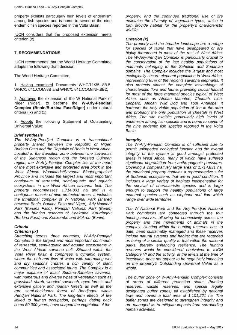
Benin / Burkina Faso – W-Arly-Pendjari Complex
property exhibits particularly high levels of endemism among fish species and is home to seven of the nine endemic fish species reported in the Volta Basin. IUCN considers that the proposed extension meets criterion (x). 7. RECOMMENDATIONS IUCN recommends that the World Heritage Committee adopts the following draft decision: The World Heritage Committee, 1. Having examined Documents WHC/11/35 8B.5, WHC/17/41.COM/8B and WHC/17/41.COM/INF.8B2; 2. Approves the extension of the W National Park of Niger (Niger), to become the W-Arly-Pendjari Complex (Benin/Burkina Faso/Niger) under natural criteria (ix) and (x). 3. Adopts the following Statement of Outstanding Universal Value: Brief synthesis The W-Arly-Pendjari Complex is a transnational property shared between the Republic of Niger, Burkina Faso and the Republic of Benin in West Africa. Located in the transition zone between the savannas of the Sudanese region and the forested Guinean region, the W-Arly-Pendjari Complex lies at the heart of the most extensive and protected area block in the West African Woodlands/Savanna Biogeographical Province and includes the largest and most important continuum of terrestrial, semi-aquatic and aquatic ecosystems in the West African savanna belt. The property encompasses 1,714,831 ha and is a contiguous mosaic of nine protected areas. It includes the trinational complex of W National Park (shared between Benin, Burkina Faso and Niger), Arly National Park (Burkina Faso), Pendjari National Park (Benin) and the hunting reserves of Koakrana, Kourtiagou (Burkina Faso) and Konkombri and Mékrou (Benin). Criteria Criterion (ix) Stretching across three countries, W-Arly-Pendjari Complex is the largest and most important continuum of terrestrial, semi-aquatic and aquatic ecosystems in the West African savanna belt. Situated within the Volta River basin it comprises a dynamic system, where the ebb and flow of water with alternating wet and dry seasons creates a rich variety of plant communities and associated fauna. The Complex is a major expanse of intact Sudano-Sahelian savanna, with numerous and diverse types of vegetation such as grassland, shrub, wooded savannah, open forests and extensive gallery and riparian forests as well as the rare semi-deciduous forest of Bondjagou within Pendjari National Park. The long-term effects of fire linked to human occupation, perhaps dating back some 50,000 years, have shaped the vegetation of the
property, and the continued traditional use of fire maintains the diversity of vegetation types, which in turn provide habitat for the property’s characteristic wildlife. Criterion (x) The property and the broader landscape are a refuge for species of fauna that have disappeared or are highly threatened in most of the rest of West Africa. The W-Arly-Pendjari Complex is particularly crucial to the conservation of the last healthy populations of mammals belonging to the Sahelian and Sudanian domains. The Complex includes the largest and most ecologically secure elephant population in West Africa, representing 85% of the region's savanna elephants. It also protects almost the complete assemblage of characteristic flora and fauna, providing crucial habitat for most of the large mammal species typical of West Africa, such as African Manatee, Cheetah, Lion, Leopard, African Wild Dog and Topi Antelope. It harbours the only viable population of lion in the area and probably the only population of cheetah in West Africa. The site exhibits particularly high levels of endemism among fish species and is home to seven of the nine endemic fish species reported in the Volta Basin. Integrity The W-Arly-Pendjari Complex is of sufficient size to permit unimpeded ecological function and the overall integrity of the system is good amongst protected areas in West Africa, many of which have suffered significant degradation from anthropogenic pressures. Covering a comparatively large area of 1,714,831 ha, the trinational property contains a representative suite of Sudanian ecosystems that are in good condition. It includes a large variety of habitats indispensable for the survival of characteristic species and is large enough to support the healthy populations of large mammal species such as elephant and lion which range over wide territories. The W National Park and the Arly-Pendjari National Park complexes are connected through the four hunting reserves, allowing for connectivity across the property and free movements of animals in the complex. Hunting within the hunting reserves has, to date, been sustainably managed and these reserves include natural systems and habitat that are regarded as being of a similar quality to that within the national parks, thereby enhancing resilience. The hunting reserves would be considered equivalent to IUCN Category VI and the activity, at the levels at the time of inscription, does not appear to be negatively impacting on the property’s Outstanding Universal Value as a whole. The buffer zone of W-Arly-Pendjari Complex consists of areas of different protection status (hunting reserves, wildlife reserves, and special legally designated buffer zones) all established by national laws and covers a total area of 1,101,221 ha. The buffer zones are designed to strengthen integrity and are managed as to mitigate impacts from surrounding human activities.
14 IUCN Evaluation Report – May 2017
Benin / Burkina Faso – W-Arly-Pendjari Complex
Protection and management requirements The property benefits from long-term legal protection through national laws and receives financial and technical support from the States and some development partners. Five of the protected areas making up the W-Arly-Pendjari Complex are protected as national parks (managed as IUCN Category II). The four hunting reserves within Benin and Burkina Faso are also managed under the same regime as national parks, noting that sustainable hunting is permitted. The hunting in these reserves is regulated through annual quotas, closely monitored and aimed at generating benefits for local communities and conservation. Although the boundaries of the property are clearly defined, known by the surrounding population and regulated, there are threats such as poaching, illegal grazing and encroachment of agricultural land which persist. Adequate measures must be undertaken to address these threats including working closely with agricultural development sectors to regulate, incentivize and raise awareness among communities surrounding the property. Monitoring of the scale of transhumance activities, which are a long-standing use, is important to ensure so that it remains sustainable in relation to the property’s Outstanding Universal Value. The property is managed in Benin by the Centre National de Gestion des Réserves de Faune (CENAGREF); and in Burkina Faso, Arly National Park is managed by the Office National des Parcs et Réserves (OFINAP) and W National Park, Burkina Faso by the State forestry administration: Direction Générale des Forêts et de la Faune (DGFF). The W National Park, Niger is managed by the Direction Générale des Eaux et Forêts (DGEF), Ministère de l'Environnement, de la Salubrité Urbaine et du Développement Durable (MESU/DD). The multi-agency responsibilities across the three States Parties require considerable and sustained effort to ensure effective coordination and harmonization of protected area policies and practice. All national parks in the Complex have a 10-year management plan all following a joint “Schéma Directeur d’Aménagement du complexe” to foster coordination. A workable system of transboundary governance is in place under a tripartite management agreement (now quadripartite with the integration of the State Party of Togo). However, ongoing efforts are needed to improve the levels of transnational cooperation for the property. Ongoing attention is needed to ensure that the traditional application of fire continues to support fire regimes which maintain Outstanding Universal Value, particularly under the influence of climate change. Similarly the three States Parties should work cooperatively with UEMOA (Union Economique et Monétaire Ouest Africaine) to plan, monitor and act such that transhumance movements taking place in the property and its buffer zones do not adversely impact on the Outstanding Universal Value. There is also a need to sustain long-term adequate funding for the W-Arly-Pendjari Complex. The States
Parties should ensure that adequate government funding is provided to manage the Complex and the necessary coordination. The West African Savannah Foundation (FSOA) created in 2012 is an endowment fund which requires further investment to ensure sustainability. It is critical that the FSOA becomes a source of funding for the entire Complex and continues to be supported and grow. Furthermore, it is important that all protected areas within the Complex are eligible to access this endowment fund. 4. Recommends that the States Parties of Benin, Burkina Faso and Niger within their adopted joint management framework:
a) Continue to strengthen and coordinate the measures to control the threat of wildlife poaching and other illegal activities including through the provision of adequate equipment and training of rangers and patrols;
b) Monitor the impacts of climate change on the ecosystems of the property, in particular to understand and anticipate any changes to the ecological outcomes resulting from the traditional application of fire and to ensure that the use of fire is based on robust ecologically-based conservation objectives;
c) Improve institutional coordination between the agencies in charge of the management of the property and the administrations responsible for agricultural development, in order to avoid potential negative impacts on the Outstanding Universal Value of the property;
d) Develop a long-term strategy for the sustainable financing of the property including strengthening the viability of the Fondation des savanes ouest-africaines (FSOA) and ensuring that all the protected areas within the property are eligible to access the funding of the FSOA;
e) Work closely with UEMOA (Union Economique et Monétaire Ouest Africaine) to plan, monitor and implement activities as described in the property’s management plan concerning transhumance taking place within the property and its buffer zones, in order to support these activities at sustainable levels and to ensure that they are not negatively impacting the property’s Outstanding Universal Value.
5. Requests the States Parties of Benin and Burkina Faso to submit a new map of the buffer zone boundaries at 1:50,000 scale to the World Heritage Centre. 6. Recommends the State Party of Niger consider designating the buffer zones which exist for the W National Park, Niger as formal World Heritage buffer zones to provide a consistent approach to buffer zones across the W-Arly-Pendjari Complex as a whole. 7. Commends the efforts of the States Parties of Benin, Burkina Faso and Niger, working with partners, for the high quality of conservation management that has been achieved in the protected areas of the Complex, and encourages these efforts to continue to improve the conservation of the property.
IUCN Evaluation Report – May 2017 15
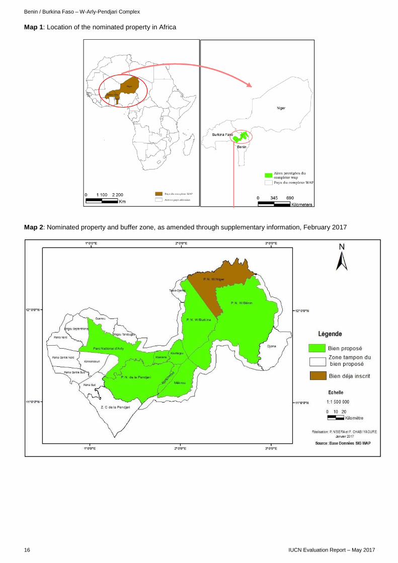
Benin / Burkina Faso – W-Arly-Pendjari Complex
Map 1: Location of the nominated property in Africa
Map 2: Nominated property and buffer zone, as amended through supplementary information, February 2017
16 IUCN Evaluation Report – May 2017
AFRICA
MOLE NATIONAL PARK GHANA
Elephants and kobs © IUCN / Wendy Strahm

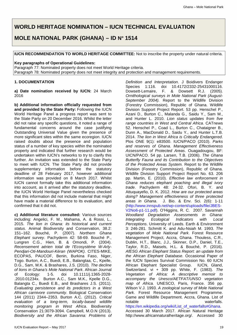
Ghana – Mole National Park
WORLD HERITAGE NOMINATION – IUCN TECHNICAL EVALUATION
MOLE NATIONAL PARK (GHANA) – ID N° 1514
IUCN RECOMMENDATION TO WORLD HERITAGE COMMITTEE: Not to inscribe the property under natural criteria. Key paragraphs of Operational Guidelines: Paragraph 77: Nominated property does not meet World Heritage criteria. Paragraph 78: Nominated property does not meet integrity and protection and management requirements. 1. DOCUMENTATION a) Date nomination received by IUCN: 24 March 2016 b) Additional information officially requested from and provided by the State Party: Following the IUCN World Heritage Panel a progress report was sent to the State Party on 20 December 2016. Whilst the letter did not raise any specific questions, it noted a range of fundamental concerns around the case justifying Outstanding Universal Value given the presence of more significant sites within the same ecoregion. IUCN raised doubts about the presence and population status of a number of key species within the nominated property and indicated that further research would be undertaken within IUCN’s networks to try to clarify this further. An invitation was extended to the State Party to meet with IUCN. The State Party did not provide supplementary information before the statutory deadline of 28 February 2017, however additional information was provided on 8 March 2017. Whilst IUCN cannot formally take this additional information into account, as it arrived after the statutory deadline, the IUCN World Heritage Panel nevertheless checked that this information did not include material that might have made a material difference to its evaluation, and confirmed that it did not. c) Additional literature consulted: Various sources including: Angelici, F. M., Mahama, A. & Rossi, L., 2015. The lion in Ghana: its historical and current status. Animal Biodiversity and Conservation, 38.2: 151–162. Bouché, P. (2007). Northern Ghana Elephant survey. Pachyderm 42: 58-69. Bouché P., Lungren C.G., Hien, B. & Omondi, P. (2004). Recensement aérien total de l’Ecosystème W-Arly-Pendjari-Oti-Mandouri-Kéran (WAPOK). CITES-MIKE, ECOPAS, PAUCOF, Benin, Burkina Faso, Niger, Togo. Burton, A.C., Buedi, E.B., Balangtaa, C., Kpelle, D.G., Sam, M.K. & Brashares, J.S. (2010). The decline of lions in Ghana’s Mole National Park. African Journal of Ecology: 1-5. doi 10.1111/j.1365-2028-.2010.01234x. Burton A.C., Sam M.K., Kpelle D.G., Balangta C., Buedi E.B., and Brashares J.S. (2011). Evaluating persistence and its predictors in a West African carnivore community. Biological Conservation 144 (2011) 2344–2353. Burton A.C. (2012). Critical evaluation of a long-term, locally-based wildlife monitoring program in West Africa. Biodiversity Conservation 21:3079-3094. Campbell, M.O.N (2013). Biodiversity and the African Savanna: Problems of
Definition and Interpretation. J Boidivers Endanger Species 1:116. doi 10.4172/2332-25431000116. Dowsett-Lemaire, F. & Dowsett R.J. (2005). Ornithological surveys in Mole National Park (August-September 2004). Report to the Wildlife Division (Forestry Commission), Republic of Ghana. Wildlife Division Support Project Report. 53 pp. Henschel P., Azani D., Burton C., Malanda G., Saidu Y., Sam M., and Hunter L. 2010. Lion status updates from five range countries in West and Central Africa. CATnews 52. Henschel P., Coad L., Burton C., Chataigner B., Dunn A., MacDonald D., Saidu Y., and Hunter L.T.B. 2014. The lion in West Africa is Critically Endangered. Plos ONE 9(1): e83500. IUCN/PACO (2010). Parks and reserves of Ghana. Management Effectiveness Assessment of Protected Areas. Ouagadougou, BF: UICN/PACO. 54 pp. Larsen, T.B. (2006). The Ghana Butterfly Fauna and its Contribution to the Objectives of the Protected Areas System. Report to the Wildlife Division (Forestry Commission), Republic of Ghana. Wildlife Division Support Project Report No. 63. 206 pp. Martin, E. (2010). Effective law enforcement in Ghana reduces elephant poaching and illegal ivory trade. Pachyderm 48: 24-32. Ofori, B. Y. and Attuquayefio, D. K. 2012. How are our protected areas doing? Management effectiveness of three protected areas in Ghana. J. Bio. & Env. Sci. 2(6): 1-11 (http://www.innspub.net/wp-content/uploads/file/JBES-V2No6-p1-11.pdf). O’Higgins, R. C. 2007. Savannah Woodland Degradation Assessments in Ghana: Integrating Ecological Indicators with Local Perceptions. University of Leeds. Earth & Environment 3: 246-281. Schmitt K. and Adu-Nsiah M. 1993. The vegetation of Mole National Park. Forest Resource Management Project, Accra, Ghana. Thouless, C.R., Dublin, H.T., Blanc, J.J., Skinner, D.P., Daniel, T.E., Taylor, R.D., Maisels, H.L. & Bouché, P. (2016). AfESG African Elephant Status Report: an update from the African Elephant Database. Occasional Paper of the IUCN Species Survival Commission No. 60 IUCN African Elephant Specialist Group. IUCN, Gland, Switzerland. vi + 309 pp. White, F. (1983). The Vegetation of Africa: A descriptive memoir to accompany the Unesco/AETFAT/UNSO vegetation map of Africa. UNESCO, Paris, France. 356 pp. Wilson V.J. 1993. A zoological survey of Mole National Park. Forest Resource Management Programme. Game and Wildlife Department. Accra, Ghana. List of notable waterfalls. https://en.wikipedia.org/wiki/List_of_waterfalls#Ghana. Accessed 30 March 2017. African Natural Heritage http://www.africannaturalheritage.org/. Accessed 30
IUCN Evaluation Report – May 2017 19
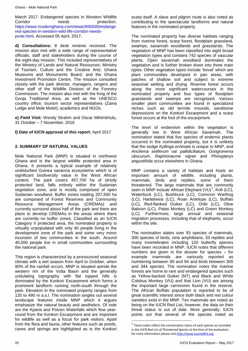
Ghana – Mole National Park
March 2017. Endangered species in Western Wildlife Corridor needs protection. https://www.modernghana.com/news/406509/endangered-species-in-western-wild-life-corridor-needs-prote.html. Accessed 05 April, 2017. d) Consultations: 8 desk reviews received. The mission also met with a wide range of representative officials, staff and stakeholders during the course of the eight-day mission. This included representatives of the Ministry of Lands and Natural Resources; Ministry of Tourism, Culture and the Creative Arts; Ghana Museums and Monuments Board; and the Ghana Investment Promotion Centre. The mission consulted closely with the park director, managers, rangers and other staff of the Wildlife Division of the Forestry Commission. The mission also met with the King of the Gonja Traditional Area, as well as the UNESCO country office; tourism sector representatives (Zaina Lodge and Mole Motel); academics and NGOs. e) Field Visit: Wendy Strahm and Oscar Mthimkhulu, 31 October – 7 November, 2016 f) Date of IUCN approval of this report: April 2017 2. SUMMARY OF NATURAL VALUES Mole National Park (MNP) is situated in northwest Ghana and is the largest wildlife protected area in Ghana. It presents a typical example of relatively undisturbed Guinea savanna ecosystems which is of significant biodiversity value in the West African context. The park covers 457,700 ha of strictly protected land, falls entirely within the Sudanian vegetation zone, and is mostly comprised of open Sudanian woodland. Buffer zones totaling 207,500 ha are composed of Forest Reserves and Community Resource Management Areas (CREMAs) and currently surround about half of the park and there are plans to develop CREMAs in the areas where there are currently no buffer zones. Classified as an IUCN Category II protected area, the nominated property is virtually unpopulated with only 40 people living in the development zone of the park and some very minor incursion of two communities in the south. Around 40,000 people live in small communities surrounding the national park. This region is characterized by a pronounced seasonal climate with a wet season from April to October, when 90% of the rainfall occurs. MNP is situated astride the western rim of the Volta Basin and the generally undulating topography with flat topped hills is dominated by the Konkori Escarpment which forms a prominent landform running north-south through the park. Elevation in the nominated property ranges from 120 to 490 m a.s.l. The nomination singles out several landscape features inside MNP which it argues emphasize the natural beauty and aesthetics. Of note are the Kparia and Polzen Waterfalls which flow year-round from the Konkori Escarpment and are important for wildlife as well as a focus for park visitors. Apart from the flora and fauna, other features such as ponds, caves and springs are highlighted as is the Konkori
scarp itself. A slave and pilgrim route is also noted as contributing to the spectacular landforms and natural features in the nominated property. The nominated property has diverse habitats ranging from riverine forest, scarp forest, floodplain grassland, swamps, savannah woodlands and grasslands. The vegetation of MNP has been classified into eight broad vegetation types and contains 742 species of vascular plants. Open savannah woodland dominates the vegetation and is further broken down into three main types. Other vegetation types include ‘boval’ which are plant communities developed in pan areas, with patches of shallow soil and subject to extreme seasonal wetting and drying. Riverine forest occurs along the more significant watercourses in the nominated property and four types of floodplain grasslands and swamps are recognized. Various smaller plant communities are found in specialized niches such as old termite mounds, sandstone depressions on the Konkori Escarpment and a scarp forest occurs at the foot of the escarpment. The level of endemism within the vegetation is generally low in West African Savannah. The nomination stated that five species of endemic plants occurred in the nominated property, but it is unlikely that the sedge Kyllinga echinata is unique to MNP, and Ancilema setiferum var pallidiciliatum, Gongronema obscurum, Raphionacme vignei and Phinopterys angustifolia occur elsewhere in Ghana. MNP contains a variety of habitats and hosts an important amount of wildlife, including plants, mammals, birds and reptiles, some of them threatened. The large mammals that are commonly seen in MNP include African Elephant (VU)1, Kob (LC), Waterbuck (LC), Bushbuck (LC), Common Warthog (LC), Hartebeest (LC), Roan Antelope (LC), Buffalo (LC), Red-flanked Duiker (LC), Oribi (LC), Olive Baboon (LC), Patas Monkey (LC) and Green Monkey (LC). Furthermore, large annual and seasonal migration processes, including that of elephants, occur within the site. The nomination states over 93 species of mammals, 300 species of birds, nine amphibians, 33 reptiles and many invertebrates including 120 butterfly species have been recorded in MNP. IUCN notes that different numbers are given in the dossier for species – for example mammals are variously reported as numbering between 90 and 94 and birds between 300 and 344 species. The nomination notes the riverine forests are home to rare and endangered species such as Yellow-backed Duiker (NT) and Black and White Colobus Monkey (VU) and that Lion (VU) are among the important large carnivores found in the reserve. The African Buffalo population is reported to be of great scientific interest since both black and red colour varieties exist in the MNP. Ten mammals are noted as being on the IUCN Red List, however, the data on their threat status is out of date. More generally, IUCN points out that several of the species noted as
1 These codes reflect the conservation status of each species as recorded in the IUCN Red List of Threatened Species at the time of the evaluation; for more information please visit http://www.iucnredlist.org
20 IUCN Evaluation Report – May 2017
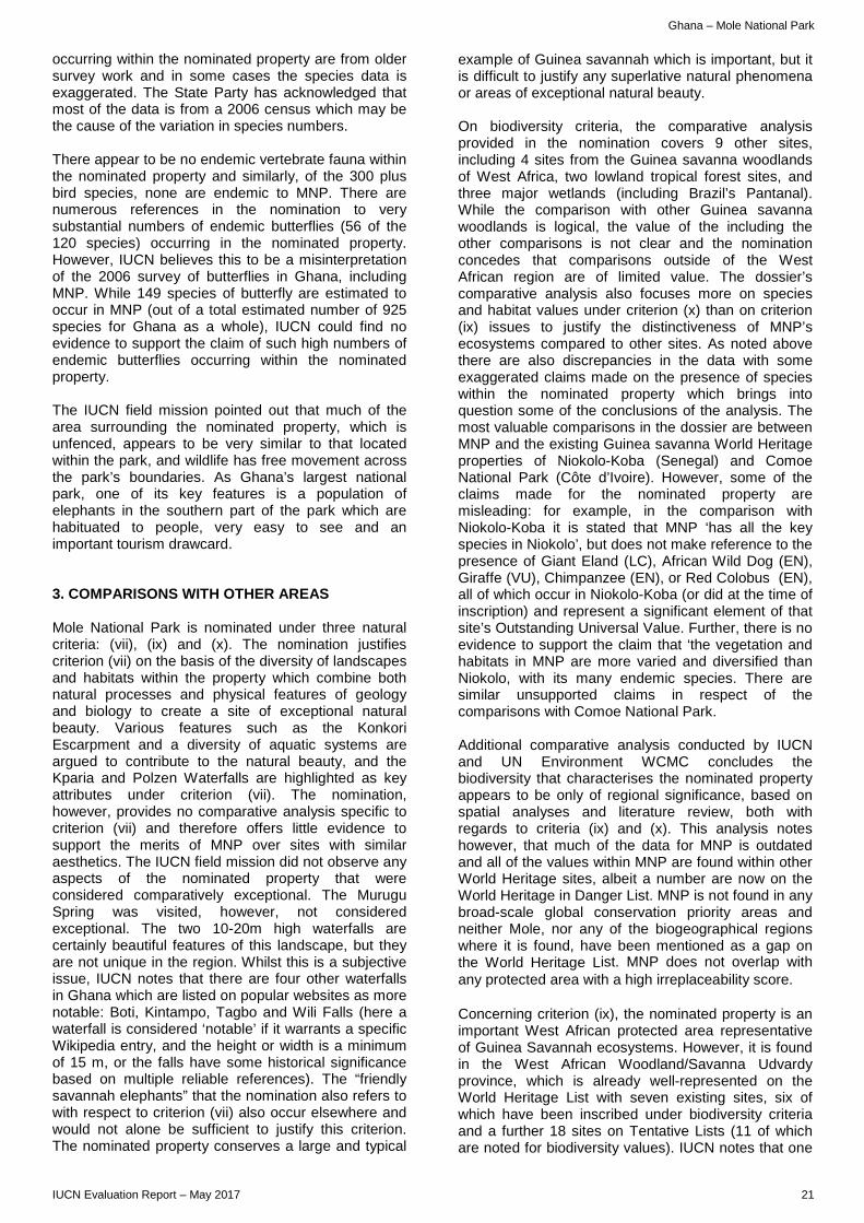
Ghana – Mole National Park
occurring within the nominated property are from older survey work and in some cases the species data is exaggerated. The State Party has acknowledged that most of the data is from a 2006 census which may be the cause of the variation in species numbers. There appear to be no endemic vertebrate fauna within the nominated property and similarly, of the 300 plus bird species, none are endemic to MNP. There are numerous references in the nomination to very substantial numbers of endemic butterflies (56 of the 120 species) occurring in the nominated property. However, IUCN believes this to be a misinterpretation of the 2006 survey of butterflies in Ghana, including MNP. While 149 species of butterfly are estimated to occur in MNP (out of a total estimated number of 925 species for Ghana as a whole), IUCN could find no evidence to support the claim of such high numbers of endemic butterflies occurring within the nominated property. The IUCN field mission pointed out that much of the area surrounding the nominated property, which is unfenced, appears to be very similar to that located within the park, and wildlife has free movement across the park’s boundaries. As Ghana’s largest national park, one of its key features is a population of elephants in the southern part of the park which are habituated to people, very easy to see and an important tourism drawcard. 3. COMPARISONS WITH OTHER AREAS Mole National Park is nominated under three natural criteria: (vii), (ix) and (x). The nomination justifies criterion (vii) on the basis of the diversity of landscapes and habitats within the property which combine both natural processes and physical features of geology and biology to create a site of exceptional natural beauty. Various features such as the Konkori Escarpment and a diversity of aquatic systems are argued to contribute to the natural beauty, and the Kparia and Polzen Waterfalls are highlighted as key attributes under criterion (vii). The nomination, however, provides no comparative analysis specific to criterion (vii) and therefore offers little evidence to support the merits of MNP over sites with similar aesthetics. The IUCN field mission did not observe any aspects of the nominated property that were considered comparatively exceptional. The Murugu Spring was visited, however, not considered exceptional. The two 10-20m high waterfalls are certainly beautiful features of this landscape, but they are not unique in the region. Whilst this is a subjective issue, IUCN notes that there are four other waterfalls in Ghana which are listed on popular websites as more notable: Boti, Kintampo, Tagbo and Wili Falls (here a waterfall is considered ‘notable’ if it warrants a specific Wikipedia entry, and the height or width is a minimum of 15 m, or the falls have some historical significance based on multiple reliable references). The “friendly savannah elephants” that the nomination also refers to with respect to criterion (vii) also occur elsewhere and would not alone be sufficient to justify this criterion. The nominated property conserves a large and typical
example of Guinea savannah which is important, but it is difficult to justify any superlative natural phenomena or areas of exceptional natural beauty. On biodiversity criteria, the comparative analysis provided in the nomination covers 9 other sites, including 4 sites from the Guinea savanna woodlands of West Africa, two lowland tropical forest sites, and three major wetlands (including Brazil’s Pantanal). While the comparison with other Guinea savanna woodlands is logical, the value of the including the other comparisons is not clear and the nomination concedes that comparisons outside of the West African region are of limited value. The dossier’s comparative analysis also focuses more on species and habitat values under criterion (x) than on criterion (ix) issues to justify the distinctiveness of MNP’s ecosystems compared to other sites. As noted above there are also discrepancies in the data with some exaggerated claims made on the presence of species within the nominated property which brings into question some of the conclusions of the analysis. The most valuable comparisons in the dossier are between MNP and the existing Guinea savanna World Heritage properties of Niokolo-Koba (Senegal) and Comoe National Park (Côte d’Ivoire). However, some of the claims made for the nominated property are misleading: for example, in the comparison with Niokolo-Koba it is stated that MNP ‘has all the key species in Niokolo’, but does not make reference to the presence of Giant Eland (LC), African Wild Dog (EN), Giraffe (VU), Chimpanzee (EN), or Red Colobus (EN), all of which occur in Niokolo-Koba (or did at the time of inscription) and represent a significant element of that site’s Outstanding Universal Value. Further, there is no evidence to support the claim that ‘the vegetation and habitats in MNP are more varied and diversified than Niokolo, with its many endemic species. There are similar unsupported claims in respect of the comparisons with Comoe National Park. Additional comparative analysis conducted by IUCN and UN Environment WCMC concludes the biodiversity that characterises the nominated property appears to be only of regional significance, based on spatial analyses and literature review, both with regards to criteria (ix) and (x). This analysis notes however, that much of the data for MNP is outdated and all of the values within MNP are found within other World Heritage sites, albeit a number are now on the World Heritage in Danger List. MNP is not found in any broad-scale global conservation priority areas and neither Mole, nor any of the biogeographical regions where it is found, have been mentioned as a gap on the World Heritage List. MNP does not overlap with any protected area with a high irreplaceability score. Concerning criterion (ix), the nominated property is an important West African protected area representative of Guinea Savannah ecosystems. However, it is found in the West African Woodland/Savanna Udvardy province, which is already well-represented on the World Heritage List with seven existing sites, six of which have been inscribed under biodiversity criteria and a further 18 sites on Tentative Lists (11 of which are noted for biodiversity values). IUCN notes that one
IUCN Evaluation Report – May 2017 21
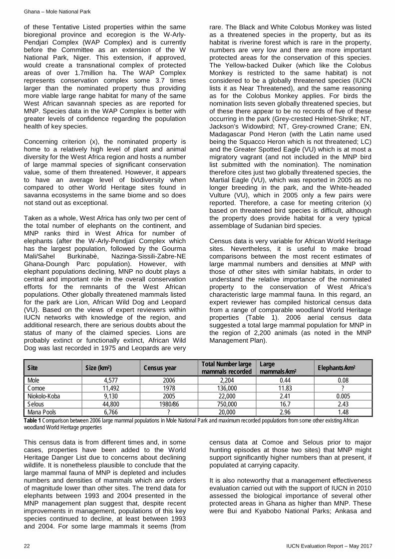
Ghana – Mole National Park
of these Tentative Listed properties within the same bioregional province and ecoregion is the W-Arly-Pendjari Complex (WAP Complex) and is currently before the Committee as an extension of the W National Park, Niger. This extension, if approved, would create a transnational complex of protected areas of over 1.7million ha. The WAP Complex represents conservation complex some 3.7 times larger than the nominated property thus providing more viable large range habitat for many of the same West African savannah species as are reported for MNP. Species data in the WAP Complex is better with greater levels of confidence regarding the population health of key species. Concerning criterion (x), the nominated property is home to a relatively high level of plant and animal diversity for the West Africa region and hosts a number of large mammal species of significant conservation value, some of them threatened. However, it appears to have an average level of biodiversity when compared to other World Heritage sites found in savanna ecosystems in the same biome and so does not stand out as exceptional. Taken as a whole, West Africa has only two per cent of the total number of elephants on the continent, and MNP ranks third in West Africa for number of elephants (after the W-Arly-Pendjari Complex which has the largest population, followed by the Gourma Mali/Sahel Burkinabè, Nazinga-Sissili-Zabre-NE Ghana-Doungh Parc population). However, with elephant populations declining, MNP no doubt plays a central and important role in the overall conservation efforts for the remnants of the West African populations. Other globally threatened mammals listed for the park are Lion, African Wild Dog and Leopard (VU). Based on the views of expert reviewers within IUCN networks with knowledge of the region, and additional research, there are serious doubts about the status of many of the claimed species. Lions are probably extinct or functionally extinct, African Wild Dog was last recorded in 1975 and Leopards are very
rare. The Black and White Colobus Monkey was listed as a threatened species in the property, but as its habitat is riverine forest which is rare in the property, numbers are very low and there are more important protected areas for the conservation of this species. The Yellow-backed Duiker (which like the Colobus Monkey is restricted to the same habitat) is not considered to be a globally threatened species (IUCN lists it as Near Threatened), and the same reasoning as for the Colobus Monkey applies. For birds the nomination lists seven globally threatened species, but of these there appear to be no records of five of these occurring in the park (Grey-crested Helmet-Shrike; NT, Jackson’s Widowbird; NT, Grey-crowned Crane; EN, Madagascar Pond Heron (with the Latin name used being the Squacco Heron which is not threatened; LC) and the Greater Spotted Eagle (VU) which is at most a migratory vagrant (and not included in the MNP bird list submitted with the nomination). The nomination therefore cites just two globally threatened species, the Martial Eagle (VU), which was reported in 2005 as no longer breeding in the park, and the White-headed Vulture (VU), which in 2005 only a few pairs were reported. Therefore, a case for meeting criterion (x) based on threatened bird species is difficult, although the property does provide habitat for a very typical assemblage of Sudanian bird species. Census data is very variable for African World Heritage sites. Nevertheless, it is useful to make broad comparisons between the most recent estimates of large mammal numbers and densities at MNP with those of other sites with similar habitats, in order to understand the relative importance of the nominated property to the conservation of West Africa’s characteristic large mammal fauna. In this regard, an expert reviewer has compiled historical census data from a range of comparable woodland World Heritage properties (Table 1). 2006 aerial census data suggested a total large mammal population for MNP in the region of 2,200 animals (as noted in the MNP Management Plan).
Site Size (km2) Census year Total Number large mammals recorded
Large mammals/km2 Elephants/km2
Mole 4,577 2006 2,204 0.44 0.08 Comoe 11,492 1978 136,000 11.83 ? Niokolo-Koba 9,130 2005 22,000 2.41 0.005 Selous 44,800 1980/86 750,000 16.7 2.43 Mana Pools 6,766 ? 20,000 2.96 1.48
Table 1 Comparison between 2006 large mammal populations in Mole National Park and maximum recorded populations from some other existing African woodland World Heritage properties This census data is from different times and, in some cases, properties have been added to the World Heritage Danger List due to concerns about declining wildlife. It is nonetheless plausible to conclude that the large mammal fauna of MNP is depleted and includes numbers and densities of mammals which are orders of magnitude lower than other sites. The trend data for elephants between 1993 and 2004 presented in the MNP management plan suggest that, despite recent improvements in management, populations of this key species continued to decline, at least between 1993 and 2004. For some large mammals it seems (from
census data at Comoe and Selous prior to major hunting episodes at those two sites) that MNP might support significantly higher numbers than at present, if populated at carrying capacity. It is also noteworthy that a management effectiveness evaluation carried out with the support of IUCN in 2010 assessed the biological importance of several other protected areas in Ghana as higher than MNP. These were Bui and Kyabobo National Parks; Ankasa and
22 IUCN Evaluation Report – May 2017
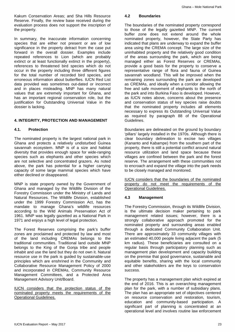
Ghana – Mole National Park
Kakum Conservation Areas; and Sha Hills Resource Reserve. Finally, the review base received during the evaluation process does not support the inscription of the property. In summary, the inaccurate information concerning species that are either not present or are of low significance in the property detract from the case put forward in the overall dossier. Examples include repeated references to Lion (which are probably extinct or at least functionally extinct in the property), references to threatened bird species which do not occur in the property including three different figures for the total number of recorded bird species, and erroneous information about butterflies. IUCN Red List data provided was sometimes out-dated or incorrect and in places misleading. MNP has many natural values that are extremely important for Ghana, and has an important regional conservation role, but the justification for Outstanding Universal Value in the dossier is lacking. 4. INTEGRITY, PROTECTION AND MANAGEMENT 4.1. Protection The nominated property is the largest national park in Ghana and protects a relatively undisturbed Guinea savannah ecosystem. MNP is of a size and habitat diversity that provides enough space for wide-ranging species such as elephants and other species which are not selective and concentrated grazers. As noted above, the park has potential for a higher carrying capacity of some large mammal species which have either declined or disappeared. MNP is state property owned by the Government of Ghana and managed by the Wildlife Division of the Forestry Commission under the Ministry of Lands and Natural Resources. The Wildlife Division, established under the 1999 Forestry Commission Act, has the mandate to manage Ghana’s wildlife resources according to the Wild Animals Preservation Act of 1961. MNP was legally gazetted as a National Park in 1971 and enjoys a high level of legal protection. The Forest Reserves comprising the park’s buffer zones are proclaimed and protected by law and most of the land including CREMAs belongs to the traditional communities. Traditional land outside MNP belongs to the King of the Gonja tribe and people inhabit and use the land but they do not own it. Natural resource use in the park is guided by sustainable-use principles which are enshrined in the Community and Collaborative Resource Management Policy of 2000 and incorporated in CREMAs, Community Resource Management Committees, and a Protected Area Management Advisory Unit/Board. IUCN considers that the protection status of the nominated property meets the requirements of the Operational Guidelines.
4.2 Boundaries The boundaries of the nominated property correspond to those of the legally gazetted MNP. The current buffer zone does not extend around the whole nominated property, however, the State Party has indicated that plans are underway to expand the buffer area using the CREMA concept. The large size of the uninhabited property and the relatively good condition of the areas surrounding the park, which are being managed either as Forest Reserves or CREMAs, provide a good basis for the property to conserve a representative range of flora and fauna of Guinea savannah woodland. This will be improved when the remaining zones surrounding the park are developed as CREMAs, and ideally when a corridor allowing the free and safe movement of elephants to the north of the park and into Burkina Faso is developed. However, as IUCN notes above, concerns about the presence and conservation status of key species raise doubts that the nominated property includes all elements necessary to express its Outstanding Universal Value as required by paragraph 88 of the Operational Guidelines. Boundaries are delineated on the ground by boundary ‘pillars’ largely installed in the 1970s. Although there is clear boundary delineation to excise two villages (Kananto and Kabampe) from the southern part of the property, there is still a potential conflict around natural resource utilization and land space because these villages are confined between the park and the forest reserve. The arrangement with these communities not to encroach and expand the village into the park needs to be closely managed and monitored. IUCN considers that the boundaries of the nominated property do not meet the requirements of the Operational Guidelines. 4.3 Management The Forestry Commission, through its Wildlife Division, is the ultimate decision maker pertaining to park management related issues; however, there is a strongly collaborative approach promoted for the nominated property and surrounding areas enabled through a dedicated Community Collaboration Unit. There are approximately 33 community villages with an estimated 40,000 people living adjacent the park (5 km radius). These beneficiaries are consulted on a regular basis through participatory planning such as management plan development and capacity building on the premise that good governance, sustainable and equitable benefits, sharing with the local community and other stakeholders are the keys to conservation success. The property has a management plan which expired at the end of 2016. This is an overarching management plan for the park, with a number of subsidiary plans. The plan has an appropriate set of objectives centered on resource conservation and restoration, tourism, education and community-based participation. A significant part of planning is concentrated at an operational level and involves routine law enforcement
IUCN Evaluation Report – May 2017 23
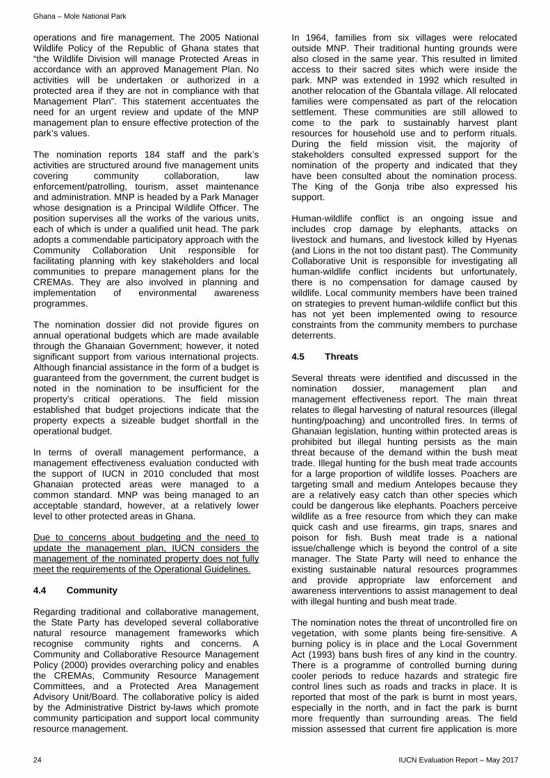
Ghana – Mole National Park
operations and fire management. The 2005 National Wildlife Policy of the Republic of Ghana states that “the Wildlife Division will manage Protected Areas in accordance with an approved Management Plan. No activities will be undertaken or authorized in a protected area if they are not in compliance with that Management Plan”. This statement accentuates the need for an urgent review and update of the MNP management plan to ensure effective protection of the park’s values. The nomination reports 184 staff and the park’s activities are structured around five management units covering community collaboration, law enforcement/patrolling, tourism, asset maintenance and administration. MNP is headed by a Park Manager whose designation is a Principal Wildlife Officer. The position supervises all the works of the various units, each of which is under a qualified unit head. The park adopts a commendable participatory approach with the Community Collaboration Unit responsible for facilitating planning with key stakeholders and local communities to prepare management plans for the CREMAs. They are also involved in planning and implementation of environmental awareness programmes. The nomination dossier did not provide figures on annual operational budgets which are made available through the Ghanaian Government; however, it noted significant support from various international projects. Although financial assistance in the form of a budget is guaranteed from the government, the current budget is noted in the nomination to be insufficient for the property’s critical operations. The field mission established that budget projections indicate that the property expects a sizeable budget shortfall in the operational budget. In terms of overall management performance, a management effectiveness evaluation conducted with the support of IUCN in 2010 concluded that most Ghanaian protected areas were managed to a common standard. MNP was being managed to an acceptable standard, however, at a relatively lower level to other protected areas in Ghana. Due to concerns about budgeting and the need to update the management plan, IUCN considers the management of the nominated property does not fully meet the requirements of the Operational Guidelines. 4.4 Community Regarding traditional and collaborative management, the State Party has developed several collaborative natural resource management frameworks which recognise community rights and concerns. A Community and Collaborative Resource Management Policy (2000) provides overarching policy and enables the CREMAs, Community Resource Management Committees, and a Protected Area Management Advisory Unit/Board. The collaborative policy is aided by the Administrative District by-laws which promote community participation and support local community resource management.
In 1964, families from six villages were relocated outside MNP. Their traditional hunting grounds were also closed in the same year. This resulted in limited access to their sacred sites which were inside the park. MNP was extended in 1992 which resulted in another relocation of the Gbantala village. All relocated families were compensated as part of the relocation settlement. These communities are still allowed to come to the park to sustainably harvest plant resources for household use and to perform rituals. During the field mission visit, the majority of stakeholders consulted expressed support for the nomination of the property and indicated that they have been consulted about the nomination process. The King of the Gonja tribe also expressed his support. Human-wildlife conflict is an ongoing issue and includes crop damage by elephants, attacks on livestock and humans, and livestock killed by Hyenas (and Lions in the not too distant past). The Community Collaborative Unit is responsible for investigating all human-wildlife conflict incidents but unfortunately, there is no compensation for damage caused by wildlife. Local community members have been trained on strategies to prevent human-wildlife conflict but this has not yet been implemented owing to resource constraints from the community members to purchase deterrents. 4.5 Threats Several threats were identified and discussed in the nomination dossier, management plan and management effectiveness report. The main threat relates to illegal harvesting of natural resources (illegal hunting/poaching) and uncontrolled fires. In terms of Ghanaian legislation, hunting within protected areas is prohibited but illegal hunting persists as the main threat because of the demand within the bush meat trade. Illegal hunting for the bush meat trade accounts for a large proportion of wildlife losses. Poachers are targeting small and medium Antelopes because they are a relatively easy catch than other species which could be dangerous like elephants. Poachers perceive wildlife as a free resource from which they can make quick cash and use firearms, gin traps, snares and poison for fish. Bush meat trade is a national issue/challenge which is beyond the control of a site manager. The State Party will need to enhance the existing sustainable natural resources programmes and provide appropriate law enforcement and awareness interventions to assist management to deal with illegal hunting and bush meat trade. The nomination notes the threat of uncontrolled fire on vegetation, with some plants being fire-sensitive. A burning policy is in place and the Local Government Act (1993) bans bush fires of any kind in the country. There is a programme of controlled burning during cooler periods to reduce hazards and strategic fire control lines such as roads and tracks in place. It is reported that most of the park is burnt in most years, especially in the north, and in fact the park is burnt more frequently than surrounding areas. The field mission assessed that current fire application is more
24 IUCN Evaluation Report – May 2017
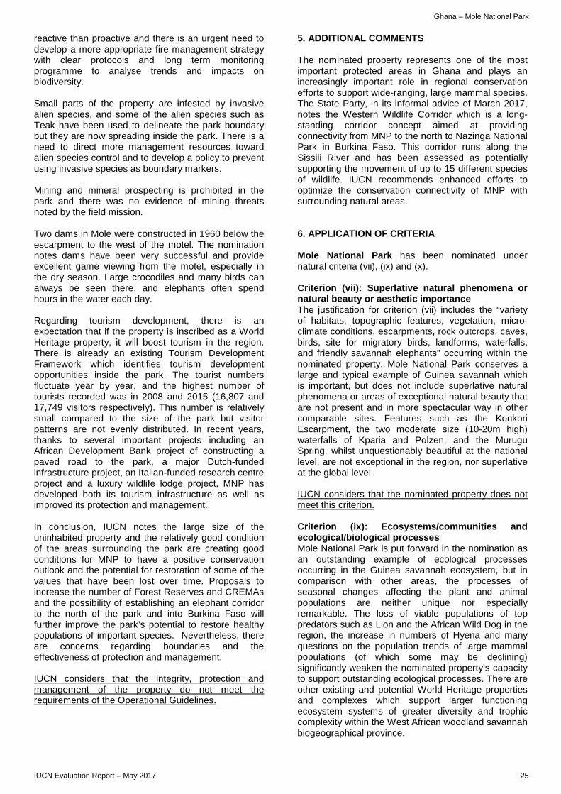
Ghana – Mole National Park
reactive than proactive and there is an urgent need to develop a more appropriate fire management strategy with clear protocols and long term monitoring programme to analyse trends and impacts on biodiversity. Small parts of the property are infested by invasive alien species, and some of the alien species such as Teak have been used to delineate the park boundary but they are now spreading inside the park. There is a need to direct more management resources toward alien species control and to develop a policy to prevent using invasive species as boundary markers. Mining and mineral prospecting is prohibited in the park and there was no evidence of mining threats noted by the field mission. Two dams in Mole were constructed in 1960 below the escarpment to the west of the motel. The nomination notes dams have been very successful and provide excellent game viewing from the motel, especially in the dry season. Large crocodiles and many birds can always be seen there, and elephants often spend hours in the water each day. Regarding tourism development, there is an expectation that if the property is inscribed as a World Heritage property, it will boost tourism in the region. There is already an existing Tourism Development Framework which identifies tourism development opportunities inside the park. The tourist numbers fluctuate year by year, and the highest number of tourists recorded was in 2008 and 2015 (16,807 and 17,749 visitors respectively). This number is relatively small compared to the size of the park but visitor patterns are not evenly distributed. In recent years, thanks to several important projects including an African Development Bank project of constructing a paved road to the park, a major Dutch-funded infrastructure project, an Italian-funded research centre project and a luxury wildlife lodge project, MNP has developed both its tourism infrastructure as well as improved its protection and management. In conclusion, IUCN notes the large size of the uninhabited property and the relatively good condition of the areas surrounding the park are creating good conditions for MNP to have a positive conservation outlook and the potential for restoration of some of the values that have been lost over time. Proposals to increase the number of Forest Reserves and CREMAs and the possibility of establishing an elephant corridor to the north of the park and into Burkina Faso will further improve the park’s potential to restore healthy populations of important species. Nevertheless, there are concerns regarding boundaries and the effectiveness of protection and management. IUCN considers that the integrity, protection and management of the property do not meet the requirements of the Operational Guidelines.
5. ADDITIONAL COMMENTS The nominated property represents one of the most important protected areas in Ghana and plays an increasingly important role in regional conservation efforts to support wide-ranging, large mammal species. The State Party, in its informal advice of March 2017, notes the Western Wildlife Corridor which is a long-standing corridor concept aimed at providing connectivity from MNP to the north to Nazinga National Park in Burkina Faso. This corridor runs along the Sissili River and has been assessed as potentially supporting the movement of up to 15 different species of wildlife. IUCN recommends enhanced efforts to optimize the conservation connectivity of MNP with surrounding natural areas. 6. APPLICATION OF CRITERIA Mole National Park has been nominated under natural criteria (vii), (ix) and (x). Criterion (vii): Superlative natural phenomena or natural beauty or aesthetic importance The justification for criterion (vii) includes the “variety of habitats, topographic features, vegetation, micro-climate conditions, escarpments, rock outcrops, caves, birds, site for migratory birds, landforms, waterfalls, and friendly savannah elephants” occurring within the nominated property. Mole National Park conserves a large and typical example of Guinea savannah which is important, but does not include superlative natural phenomena or areas of exceptional natural beauty that are not present and in more spectacular way in other comparable sites. Features such as the Konkori Escarpment, the two moderate size (10-20m high) waterfalls of Kparia and Polzen, and the Murugu Spring, whilst unquestionably beautiful at the national level, are not exceptional in the region, nor superlative at the global level. IUCN considers that the nominated property does not meet this criterion. Criterion (ix): Ecosystems/communities and ecological/biological processes Mole National Park is put forward in the nomination as an outstanding example of ecological processes occurring in the Guinea savannah ecosystem, but in comparison with other areas, the processes of seasonal changes affecting the plant and animal populations are neither unique nor especially remarkable. The loss of viable populations of top predators such as Lion and the African Wild Dog in the region, the increase in numbers of Hyena and many questions on the population trends of large mammal populations (of which some may be declining) significantly weaken the nominated property’s capacity to support outstanding ecological processes. There are other existing and potential World Heritage properties and complexes which support larger functioning ecosystem systems of greater diversity and trophic complexity within the West African woodland savannah biogeographical province.
IUCN Evaluation Report – May 2017 25
Ghana – Mole National Park
IUCN considers that the nominated property does not meet this criterion. Criterion (x): Biodiversity and threatened species The nominated property is well protected, and has the potential to play an important regional role in the conservation of some key species in the future when updated and current species occurrence, distribution and numbers are known. Despite it being an important refuge for a representative cross-section of flora and fauna of Guinea savannah woodland, it is difficult to identify a flagship species that is globally threatened for which Mole National Park offers exceptional conservation value at the level to demonstrate Outstanding Universal Value. For mammals, the elephant population is clearly important, but data is lacking as the last census took place in 2006, and other areas in West Africa host much larger elephant populations. The other species of global significance mentioned in the nomination dossier, such as the Lion are not believed to sustain viable populations in the property. The nominated property does not display particularly high levels of endemism among plants and animals as is the case generally for this biome. Furthermore, MNP does not correspond to any global biodiversity priority areas; has not been identified as filling a gap on the World Heritage List; and is not a protected area with high irreplaceability in terms of threatened species. IUCN considers that the nominated property does not meet this criterion. 7. RECOMMENDATIONS IUCN recommends that the World Heritage Committee adopts the following draft decision:
The World Heritage Committee, 1. Having examined Documents WHC/17/41.COM/8B and WHC/17/41.COM/INF.8B2; 2. Decides not to inscribe Mole National Park (Ghana) on the World Heritage List under natural criteria. 3. Commends the State Party for its efforts to protect and manage Mole National Park as an important refuge for a representative cross-section of flora and fauna of Guinea savannah woodland and its initiatives to strengthen collaborative natural resource management with local communities surrounding the national park. 4. Recommends the State Party, with the support of IUCN and partners as appropriate, to continue its efforts to strengthen the conservation of Mole National Park, with emphasis on:
a) updating the Mole National Park management plan, which expired in 2016;
b) updating wildlife census data to better understand the conservation status of key species within the national park;
c) restoring, where possible, key wildlife populations for which the national park has the potential to provide suitable habitat;
d) establishing additional Community Resource Management Areas adjoining the national park to act as buffer zones;
e) enhancing ecological connectivity through the creation of improved buffer zones and the development of wildlife corridors; and
f) updating tourism planning for the national park to anticipate growing tourism demand and to ensure sustainability.
26 IUCN Evaluation Report – May 2017
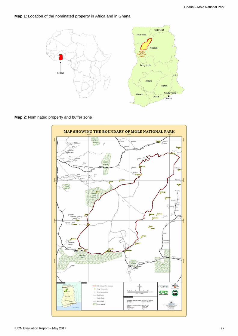
Ghana – Mole National Park
Map 1: Location of the nominated property in Africa and in Ghana Map 2: Nominated property and buffer zone
IUCN Evaluation Report – May 2017 27

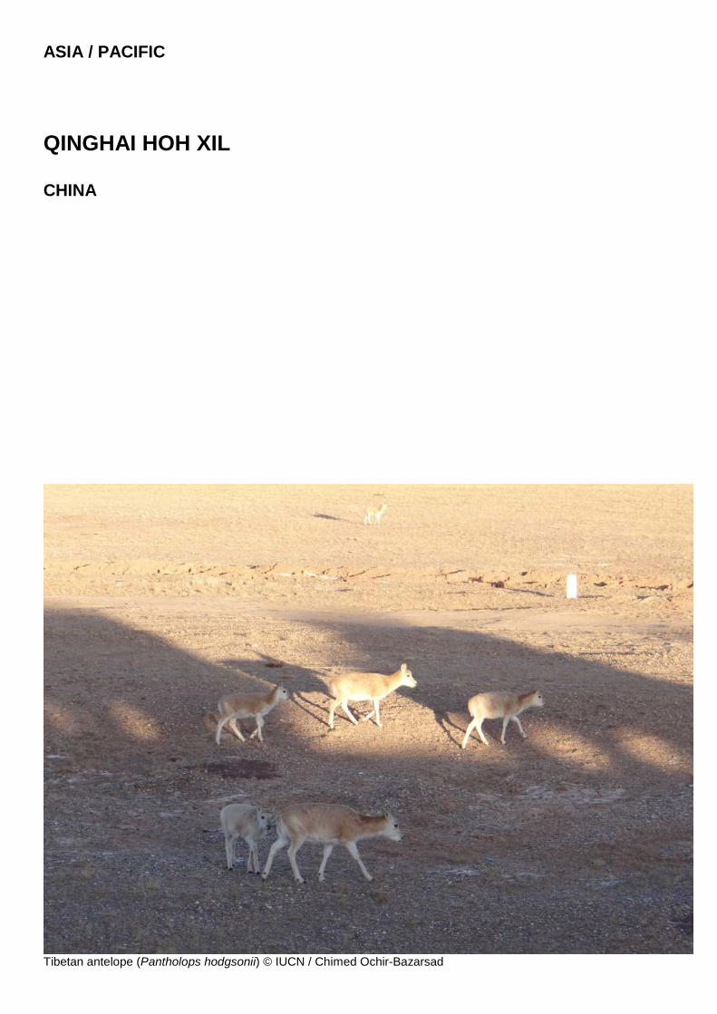
ASIA / PACIFIC
QINGHAI HOH XIL CHINA
Tibetan antelope (Pantholops hodgsonii) © IUCN / Chimed Ochir-Bazarsad

China – Qinghai Hoh Xil
WORLD HERITAGE NOMINATION – IUCN TECHNICAL EVALUATION
QINGHAI HOH XIL (CHINA) – ID N° 1540
IUCN RECOMMENDATION TO WORLD HERITAGE COMMITTEE: To inscribe the property under natural criteria. Key paragraphs of Operational Guidelines: Paragraph 77: Nominated property meets World Heritage criteria. Paragraph 78: Nominated property meets integrity, protection and management requirements. 1. DOCUMENTATION a) Date nomination received by IUCN: 24 March 2016 b) Additional information officially requested from and provided by the State Party: Following the IUCN World Heritage Panel a progress report was sent to the State Party on 20 December 2016. This letter advised on the status of the evaluation process and sought responses/clarifications on a range of issues including clarifications in relation to the delimitation of the property, the justification of boundaries, future plans and management of the transport corridor that crosses the area, commitments in relation to traditional communities within the nominated property, and measures related to the control of poaching, and the use of poison for the control of Pika. A meeting with representatives of the State Party was held at IUCN Headquarters on 20 February 2017 to discuss the response to these questions. A formal response from the State Party to the issues raised in the progress report was received by the World Heritage Centre on 24 February 2017. c) Additional literature consulted: Various sources, including: Badingqiuying, Smith, A.T., Senko, J. and Siladan, M.U. 2016. Plateau pika (Ochotona curzoniae) poisoning campaign reduces carnivore abundance in southern Qinghai, China, Mammal Study 41: 1–8. Berger J., Cheng E., Kang A., Krebs M., Li L., Xin Lu Z., Buzhou B., and Schaller G.B. 2014. Sex differences in ecology of wild yaks at high elevation in the Kekexili Reserve, Tibetan Qinghai Plateau, China. Journal of Mammalogy 95(3): 638-645; Buzzard, P., and Berger, J. 2016. Bos mutus. The IUCN Red List of Threatened Species 2016: e.T2892A101293528. Fund, W. 2013. Central Tibetan Plateau alpine steppe. Retrieved from http://www.eoearth.org/, accessed in November 2016. Fund, W. 2014. North Tibetan Plateau-Kunlun Mountains alpine desert. Retrieved from http://www.eoearth.org/, accessed in November 2016. Harris R.B, Pletscheer K.H., Loggers C.O., and Miler D.J. 1999. Status and trend of Tibetan plateau mammalian fauna, Yeniugou China. Biological Conservation 87: 13-19. Huang W., Xia L., Yang Q., and Feng Z. 2008. Distribution pattern and zoogeographical division of mammals on the Qinghai-Tibet Plateau. Acta Theriologica Sinica 28(4): 375-394. IUCN SSC Antelope Specialist Group. 2016. Pantholops hodgsonii. The IUCN Red List of Threatened Species 2016: e.T15967A50192544.
Schaller G.B., and Wulin L. 1996. Distribution, status and conservation of wild yak Bos grunniens. Biological Conservation 76: 1-8. Qi D., Chao Y., Guo S., Zhao L., Li T., WeiF., and Zhao X. 2012. Convergent, Parallel and Correlated Evolution of Trophic Morphologies in the Subfamily Schizothoracinae from the Qinghai-Tibetan Plateau. PLoS One 7(3): e34070. WWF (2016) List of ecoregions. Downloaded from http://wwf.panda.org/about_our_earth/ecoregions/ecoregion_list/, accessed in November 2016. d) Consultations: 14 desk reviews received. The mission met with a wide range of stakeholders including national level officials from the Ministry of Housing and Urban-Rural Development and a range of senior technical specialists and scientists. Meetings involved the National Commission of UNESCO, and a visit was made to the IUCN office in China. The main authorities responsible for the property at local level were met, including the Qinghai World Heritage Management Office, Secretary-General of The Party Committee of Yushu Tibetan Autonomous Prefecture, Governor of Yushu Tibetan Autonomous Prefecture, and local mayors and community leaders. Directors and senior technical specialists within the relevant technical departments of the local authorities were also met, and meetings with community representatives included local village committees, herders, as well as staff from schools and museums were held. e) Field Visit: Chimed-Ochir Bazarsad and Carlo Ossola, 27 October - 6 November 2016 f) Date of IUCN approval of this report: April 2017 2. SUMMARY OF NATURAL VALUES The nominated property, Qinghai Hoh Xil, is located in Qinghai Province, in the northeast part of the Qinghai-Tibetan Plateau in China. The property is a single and very large contiguous area of 3,735,632 ha and comprises sectors of two adjoining protected areas: Hoh Xil National Nature Reserve in the west and the Soja-Qumar River sub-zone of Sanjiangyuan National Nature Reserve in the east. The nominated area connects these two protected areas via three 20 km wide corridors which span the Qinghai Tibet Highway and Railway, which is a major transport corridor crossing the area from north-south and discussed further in the section on threats below. The sections of this corridor that are not included in the corridors are
IUCN Evaluation Report – May 2017 31
China – Qinghai Hoh Xil
designated as buffer zone areas. A further large area of buffer zone adjoins the nominated property in the east and south, and also lies completely within the same two Nature Reserve areas, creating a total buffer zone of 2,290,904 ha. Buffer zones are not designated to the west and north of the nominated property: the nominated property is bordered to the west and northwest by the Changtang National Nature Reserve in the Tibetan Autonomous Region and by the Altun Mountain National Nature Reserve in the Xinjiang Autonomous Region. In the north the property is bordered by the Kunlun Mountains, and for a small part of its boundary by the Golmud Kunlun Mountains National Geological Park. The Qinghai-Tibetan Plateau is the largest, highest and youngest plateau in the world, and, within this area the nominated property encompasses an extensive area of alpine mountains and steppe systems at elevations of over 4,500m above sea level. The area has a frigid plateau climate, with sub-zero average year-round temperatures and the lowest temperature occasionally reaching -45°C. With its ongoing processes of geological formation, the nominated property includes a large planation surface and basin on the Qinghai-Tibet Plateau. It is the area with the highest concentration of lakes on this Plateau, exhibiting an exceptional diversity of lake basins and inland lacustrine landscapes at high altitude. The very large scale of the area and its substantially natural conditions create an area with exceptional natural beauty, whose aesthetic values are related to the experience of wild nature. The high plateau systems function unimpeded on a grand scale, wildlife is vividly juxtaposed against vast treeless backdrops, and tiny cushion plants contrast against towering snow covered mountains. In the summer, the tiny cushion plants form a sea of vegetation, which when blooming creates waves of different colours. Glacial melt waters create numerous braided rivers which are woven into huge wetland systems forming tens of thousands of lakes. The lakes display a full spectrum of succession stages, forming an important catchment at the source of the Yangtze River and a spectacular landscape. The geographical and climatic conditions nurture a similarly unique biodiversity. More than one third of the plant species, and all the herbivorous mammals dependent on them are endemic to the plateau, and 60% of the mammal species as a whole are plateau endemics. High levels of endemism within the flora of the property are associated with high altitudes and cold climate and contribute to similarly high levels of endemism within the fauna. Alpine grasslands make up 45% of the total vegetation in the property dominated by the grass Stipa purpurea. Other vegetation types include alpine meadows and alpine talus. Over one third of the higher plants found in the property are endemic to the Plateau and all of the herbivorous mammals that feed on these plants are also Plateau endemics. There are 74 species of vertebrates in Hoh Xil, including 19 mammals, 48 birds, six fish, and one reptile (Phrynocephalus vliangalii). The property is home to Tibetan antelope
(Pantholops hodgsonii - NT1), wild yak (Bos mutus - VU), Kiang/Tibetan wild ass (Equus kiang - LC), wolf (Canis lupus - LC) and brown bear (Ursus arctos - LC) and the Tibetan gazelle (Procapra picticaudata - NT), all of which are frequently observed. Large numbers of wild ungulates depend on the property including almost 40% of the world's Tibetan antelope and an estimated 32-50% of the world's wild Yak. Hoh Xil conserves the habitats and natural processes of a complete life cycle of the Tibetan antelope, including the phenomenon of congregating females giving birth after a long migration. In early summer each year, tens of thousands of female Tibetan antelopes migrate for hundreds of kilometres from wintering areas in Changtang in the west, the Altun Mountains in the north and Sanjiangyuan in the east to Hoh Xil’s lake basins to calve. The property secures the complete antelope migratory route between Sanjiangyuan and Hoh Xil, and the calving grounds for other routes. The calving grounds in Hoh Xil support up to 30,000 animals each year and include almost 80% of the identified birth congregation areas in the entire antelope range. During the winter, some 40,000 Tibetan antelopes remain in the property, accounting for 20-40% of the global population. There is limited human presence in the property, outside of the impacts of the transport corridor, however it should be noted that the area is the location for long-standing traditional grazing, and this is also further discussed below in the section on communities. 3. COMPARISONS WITH OTHER AREAS The property is nominated in relation to criteria (vii) and (x), and the nomination includes an adequate comparative analysis, which is stronger in relation to the latter of the two criteria. In relation to criterion (vii), notable features include the presence as part of the world’s highest and youngest plateau (however reviewers question if the selected area can claim to be the most exception representation of the plateau), the predominance, diversity and density of lakes, the exceptional hydrological system characterized by a succession of glaciers, marshlands, rivers and lake, and the calving areas of the Tibetan antelope as well as the seasonal migration of a large proportion of the existing population of this species in this area every year. The migration of ungulates in such an ecosystem is also exceptional and a comparison of the migration of mammals over long distances and vast areas is attempted in the nomination dossier. Whilst many other migration phenomena are very impressive and important, it is notable that the nominated property includes one important migration route in its entirety, and extensive calving grounds for other routes, even if they extend beyond the property’s boundaries. The observation of the migration in such a remarkable landscape is, of
1 These codes reflect the conservation status of each species as recorded in the IUCN Red List of Threatened Species at the time of the evaluation; for more information please visit http://www.iucnredlist.org
32 IUCN Evaluation Report – May 2017
China – Qinghai Hoh Xil
itself, an exceptional aesthetic experience. The broader scenic values, as enumerated above, are impressive on a global scale, even if, despite the very large size of the area nominated, they can be regarded as being only a small part of the overall area of the Qinghai-Tibet Plateau. Overall the property appears clearly able to make a strong case for the application of criterion (vii) when compared with other properties that have already been listed under this criterion. IUCN has carefully considered the biodiversity values of the property, including via a comparative analysis undertaken with UN Environment WCMC. IUCN concludes that the biodiversity that characterises the nominated property appears to be of global significance, especially with regard to criteria (x). Compared to existing sites found in the same biome, the nominated site appears to have a relatively low level of biodiversity, however, surveys might still be incomplete. But more importantly, it is home to a high proportion of species endemic to the Qinghai-Tibet Plateau and a significant number of threatened species. The presence of endemic ungulate species such as the Tibetan antelope and Tibetan wild yak is particularly noteworthy, with large populations inhabiting the property. The nominated property is not found in a biogeographical unit which has been mentioned as a gap on the World Heritage list. However, it overlaps with two protected areas listed amongst the most irreplaceable in the world, especially with regard to their importance for mammal and bird species. Both the information provided by the nomination file on the high level of endemism and the results of the irreplaceability analysis suggest that the nominated property is globally important for the conservation of a number of range restricted species endemic to the Tibetan Plateau. As touched on above, this is further demonstrated by exceptionally high irreplaceability scores for the two protected areas that overlap significantly with the nominated property. Sanjiangyuan National Nature Reserve (which overlaps at 23.4% with the nominated site) encompasses over 10% of the global distribution range of dozens of mammal, bird and amphibian species, making it the most or one of the two most important protected areas for many of these species worldwide, and especially mammals and birds. This includes for instance almost the entire distribution of the Smokey Vole (Lasiopodomys fuscus - LC) and Tibetan dwarf hamster (Cricetulus tibetanus - LC), and a significant proportion of the range of important mammal species, such as the White-lipped Deer (Przewalskium albirostris - VU), the Tibetan antelope or Chiru (Pantholops hodgsonii - EN), and the Alpine Musk Deer (Moschus chrysogaster - EN). This protected area also protects bird species of great conservation importance, including more than two third of the world distribution of the Tibetan rosefinch (Carpodacus roborowskii - LC), as well as one third of the range of the Tibetan bunting (Emberiza koslowi - NT), and parts of the range of 44 other birds of conservation importance. Hoh Xil Nature Reserve (which overlaps at 75.7% with the nominated site) contains less species of global conservation importance but is still particularly significant for the conservation of the Wild
Yak (Bos mutus) and Ladak Pika (Ochotona ladacensis - LC). IUCN considers that, whilst this analysis indicates that there is clear potential to consider extensions to the area nominated, the comparative analysis indicates a strong basis to apply criterion (x) to the property. Amongst the large review base for the nomination, from various countries and backgrounds, there is a clear view in favour of the application of both criteria that are the basis for the nomination. The nominated property is not nominated in relation to criterion (ix). It overlaps with some biogeographic and biome contexts which are already represented on the World Heritage list, but it also belongs to two terrestrial ecoregions which are not yet represented on the World Heritage list: Central Tibetan Plateau alpine steppe and North Tibetan Plateau-Kunlun Mountains alpine desert. However, it does not overlap with any biodiversity hotspots, wilderness areas, Endemic Bird Areas or Centres for Plant Diversity. A small number of reviewers also noted that a case for criterion (viii) could have been considered. In summary, IUCN considers that there is a clear basis for the nominated area to justify both of the natural criteria under which it has been nominated. IUCN notes that there are arguments that an even greater area could have been included to further strengthen the values included in the nomination, notably in relation to the adjoining nature reserve areas, and the remainder of the highly irreplaceable protected areas of which the nominated area is part. 4. INTEGRITY, PROTECTION AND MANAGEMENT 4.1. Protection The nominated property, and its buffer zone lie within two protected areas (Hoh Xil and Sangjiangyuan Nature Reserves), which have the same national legal protection status. The two protected areas are national level nature reserves and are protected by the Regulation of the People’s Republic of China on Nature Reserves (adopted 1994). Accordingly, before nomination, the management authorities of both Nature Reserves have been set up with relevant structures and staffing. After the nomination, the Conservation Regulation of the Hoh Xil Natural Heritage Area in Qinghai Province, was adopted by the Standing Committee of Qinghai Provincial People’s Congress, valid from October 2016. The Conservation Regulation regulates planning, protection, management and utilization activities within the territory of nominated property and its buffer zone. According to this regulation an administrative authority for the nominated property will be set up under the Department of Housing and Urban-Rural Development of Qinghai Province to assume protection and management responsibility for the property.
IUCN Evaluation Report – May 2017 33
China – Qinghai Hoh Xil
As noted above, two other national level Nature Reserves, Chang Tang and Altun Mountain Nature Reserve, provide further buffering functions, although are not included as a formal World Heritage buffer zone. The Kunlun Mountains provide a natural barrier to the north of the nominated property. IUCN considers that the protection status of the nominated property meets the requirements of the Operational Guidelines. 4.2 Boundaries The boundaries of the nominated property are clearly identified but present a number of issues that were raised in the course of the IUCN evaluation, and where supplementary information was requested, and received, from the State Party. The first issue is that, despite the large size of the property there would be a case, in view of the high irreplaceability scores, to include more of the Sanjiangyuan Nature Reserve in the property, and also to include other neighbouring areas which include additional areas related to the migration of Tibetan antelope, or hold other complementary values of equal or greater significance than the nominated property (such as the Chang Tang Nature Reserve, which is reported to be even more significant for Wild yak than the nominated property). In its reply to IUCN’s request, the State Party notes that only the less inhabited parts of Sanjiangyuan Nature Reserve were nominated at this stage, in view of avoiding conflicts with herding use. It further notes that it sees the present nomination serving as a flagship and that Changtang Nature Reserve and Altun Mountains Nature Reserve may be nominated as extensions to the nomination “when conditions permit”. IUCN considers that there is a clear basis to consider the nomination as the first step towards a larger site, and recommends that the State Party give consideration to further extensions, that could, inter alia, both increase the coverage of migration routes and include more of the most irreplaceable biodiversity conservation values in the adjoining areas. The second issue is the absence of buffer zone arrangements to the west and north of the property. To the west and northwest the situation is that buffering is provided by the adjacent Nature Reserves (Chang Tang and Altun), but they are not designated as part of the formal World Heritage buffer zone. The State Party’s answer (as noted above) implies that there could be consideration to include these areas as extensions to the property in the future. The State Party also indicates that there is institutionalized cooperation between these reserves and those that make up the nominated property, through a functional “conservation union” established in 2010. IUCN considers that this provides a workable means of buffering the property, and given the areas are in different provinces, provides some administrative simplicity. Nevertheless, it is important that the State Party ensures that Chang Tang and Altun function effectively to protect the nominated property, and that the cooperative arrangements are supported and
strengthened, including being adopted at higher institutional levels within the different local administrations. To the north of the property there is no buffer zone, and the State Party indicates that the remote nature and natural barrier of the Kunlun Mountains renders this unnecessary. IUCN considers that, provided the State Party remains vigilant to ensure than no unexpected threats arise in this area, this is a reasonable position at the present time, but would recommend that the State Party considers further the opportunities to establish a more formalized level of protection for the property in this area. The third issue is the designation of the buffer zones around the sections of the transport corridor within the property. The specification of these areas is discussed further below in the section on threats. The nomination excludes the majority of the 4km strip along the road corridor (with the exception of the areas managed as migratory corridors) from the nominated property, and gives these areas buffer zone status. These buffer areas that are internal to the property are covered by the same legislation as the rest of the Nature Reserves, and in principle IUCN considers it would benefit the protection of the property if these areas were eventually to be added to be part of the inscribed property, rather than remaining as buffer zones. However, as they will be afforded the same level of strict protection from development as the remainder of the property, IUCN does not regard their inclusion in the property to be an essential requirement prior to possible inscription on the World Heritage List. Whilst noting both scopes to further improve buffer arrangements, and to also consider future extensions to the area currently nominated, IUCN considers that the boundaries of the nominated property meet the requirements of the Operational Guidelines. 4.3 Management The nomination notes that the separate administrations of Hoh Xil Nature Reserve and Sanjiangyuan Nature Reserve are the local management authorities for the nominated property. A Qinghai World Heritage Declaration Leading Group and Qinghai World Heritage Management Office is also established to be responsible for the nomination process and guidance for national parks and World Heritage. The nomination outlines the national, provincial and site level responsibilities that are in place and details a number of agencies involved in the nomination process that will be turned into management agencies in charge of the protection of nominated property and the buffer zone should the property be inscribed. Specifically in this regard, the nomination notes that Hoh Xil Nature Reserve Administration and Sanjiangyuan Nature Reserve Administration will be integrated to establish a unified management agency to be responsible for the management of the nominated property and the buffer zone upon inscription. The World Heritage Management Office for the property will be responsible for building cooperation and coordination between the
34 IUCN Evaluation Report – May 2017
China – Qinghai Hoh Xil
two nature reserve administrations and other stakeholders, and ensuring that management plans are effectively implemented. As detailed in the nomination, there are a series of plans in place for the area, and a specific management plan related to World Heritage, Qinghai Hoh Xii Property Management Plan (2015-2020), was approved in 2015 based on recognition of a substantial wilderness zone across the large majority of the area, and an exhibition zone in the north-eastern part where activities related to management, and the provision of tourism related opportunities would be focused. The management plan appears to provide an adequate basis for the management of the property. The plan will undergo an anticipated regular review (starting with the first update scheduled for completion in 2020) to allow improvements to be made over time, and to address a number of issues that are further discussed in the different sections of this evaluation report. There appears to be adequate capacity to implement the management plan with clear commitment from national and provincial levels, and amongst local government. At ground level, the management authorities of the two nature reserves that cover the nominated property are responsible for implementation. Their staff numbers have been increased recently, and the permanent staff in both reserves was noted by the IUCN mission as c.135 (49 staff in Zhiduo Administration Division, 49 staff in Qumalai Administrative Division and 37 staff in Hoh Xil Administrative Division). In addition, there are 13 team members based at village level. There are a number of means by which management could be strengthened, and deserve attention. A number of these matters were raised and responded to in the request for supplementary information made by IUCN to the State Party, including an extensive discussion on monitoring plans. There appears to be a need to strengthen and focus monitoring efforts (as noted below) and it would be beneficial to institute an ongoing means to track management effectiveness, using methods developed by IUCN through the World Commission on Protected Areas, and ensure systematic feedback into improvements in property management. It would also be desirable to strengthen the participation of the local herding community within management activities, noting there is already some notable engagement. Whilst the good cooperation between the two reserves and the neighbouring reserves to the west is noted, this should be strengthened and institutionalized at a higher level. IUCN considers that the management of the nominated property meets the requirements of the Operational Guidelines. 4.4 Community According to the nomination, there are 35 households of 156 herders within the nominated property, and 222 households of 985 herders and 250 other residents in the buffer zone. The activities of nomadic herders are a long-standing and traditional use in the property, and has coexisted with the nature conservation values.
The level of involvement of the local communities and users in the preparation of the nomination proposal seems limited and unstructured. The management plan elaborates a section on community involvement and development, including a pilot programme for participative management approaches in Sanjiangyuan Nature Reserve, and there is involvement of local communities in monitoring activities. The nomination refers to overgrazing, and the introduction of new grazing activities as threats and notes that grassland deterioration and desertification is observed as a result of overgrazing in some parts of the Soja-Qumar sub-zone. Currently the nature reserves are responsible for controlling grazing activities, and the nomination notes that across the large part of the property, the management agency will “gradually impose a ban on herding among sparse residences in the resettlement area and further consider specific voluntary resettlement policies, locations, compensation mechanisms and other measures that can promote the wellbeing of the resettlements.” Herders in the buffer zone are being engaged in grassland conservation and livestock reduction policies, and local herders have been organized to participate in the conservation practices. The evaluation mission heard concern within the local population regarding being displaced or resettled as a result of the nomination process and outcomes, and several reviewers raised the issue as of concern. IUCN considers that it is imperative that questions of rights, access and traditional use are addressed rigorously and carefully by the State Party, in full consultation, and the World Heritage nomination must not be used to justify any deprivation of traditional land use rights of the concerned communities. In response to concerns raised, the State Party has stated unequivocally that there will be no forced relocation or exclusion of the traditional users of the nominated site, whether before or after succeeding in the application for World Heritage site. It will be important that this commitment is put into practice in full. IUCN further recommends that the specific sections on traditional use are strengthened in the management plan, and that the revision of the plan involves an enhanced level of consultation and the direct involvement of representatives of the traditional herding community in governance and decision-taking. IUCN would be pleased to provide further advice regarding appropriate standards and methods in this regard. 4.5 Threats The property faces a number of threats which require careful attention, as enumerated below. The most obvious of the threats is the transportation corridor that runs across the nominated property, at the boundary between the two nature reserves. The corridor includes a highway and a railway. The Qinghai-Tibet Highway is a long-standing presence that is heavily used, and severely affects the migration route of the Tibetan antelope from the Sanjaiguyan Nature Reserve to their calving grounds and back, as well as the movement of wildlife in general and the
IUCN Evaluation Report – May 2017 35
China – Qinghai Hoh Xil
ecological functioning of the plateau, and thus is an impact on values related to both criteria (vii) and (x). The long-standing management response is that the guards of the Hoh Xil Nature Reserve block the traffic for up to two hours per day during the migration period at passing points to let the animals cross the highway. This intervention is demonstrably effective, as the population of antelopes has been rising. The highway affects also the other population of animals like the Wild yak and other ungulates. No monitoring of the animal mortality due to the highway (and other corridor infrastructure) is in place to assess this impact, and no management response is currently being undertaken for other species. The traffic on the highway is growing due to development occurring in the Tibet Province, and the road will remain a conflict in the future if relevant management responses are not met. IUCN sought information from the State Party about the status and future plans for the road, and the State Party has confirmed that at the present time there is no committed plan for road upgrading. It would be essential that, should the State Party take action to upgrade the road (including the options to reduce its impact on migration, such as underpasses), that such a project should be subject to a very thorough and careful assessment, involving leading expertise. In the meantime, two clear essential requirements are to maintain the current and apparently effective management of the road, and to monitor continuously its effectiveness. It would also be important to improve the level of monitoring of the impacts of the road on wildlife, including tracking details of roadkill, in order to also consider if impacts on other species than the Tibetan antelope require enhanced protection measures. The Qinghai-Tibet Railway, in contrast to the road, is a relatively recent construction that addressed the migration routes through the creation of underpasses which are very large and effective. As with the road there is a need to provide continuous monitoring of the effectiveness of wildlife passage to ensure that the current measures remain effective. Power supply lines are also included within the transport corridor, and are a potential treat to birds. The authorities in charge of the national grid have taken measures to assess threats and provide measures to discourage bird strike, but there is a need to both monitoring and report on their effectiveness, and to consider that as the environment evolves, some bird species may become settled in the property requiring different measures to be considered. A further key issue raised with the State Party was the status of parts of the transport corridor as buffer zone. The State Party has stated to IUCN that there is no intention that those areas of the corridor that are buffer zone would be subject to any additional development pressures and are managed in the same way as the rest of the corridor, with the exception that they are not areas where migration corridors are provided across the road. In the view of IUCN it would be more effective to have the whole of the transport corridor
included in the nominated property, in order to ensure that the property managers retain the maximum level of control over the potential environmental impacts on Outstanding Universal Value from the current operation of the corridor, and any proposed upgrading of this infrastructure. The IUCN mission noted concern regarding poisoning campaigns for the eradication of the small mammal Pika ochtona, which is a current threat of medium severity to the biodiversity. There is mounting evidence that Pikas are a keystone species that provide critical ecological services in the alpine meadow ecosystem. Thus poisoning would potentially impact on the functioning of the ecosystem and on the biodiversity of the nominated property. No organised management response to Pika is in place, although it is understood that the Hoh Xil Nature Reserve Administration has in the past refused to put in place eradication campaigns, and not accept financial subsidies, thus this issue has been primarily related to practice in Sanjiangyuan Nature Reserve. In response to a concern raised by IUCN, the State Party notes that no poisoning will be planned in the nominated area and the buffer zone. Division of land and fencing campaigns led by the government, for husbandry purpose as well as anti-desertification and wetland protection purposes, are notable current threats, as fencing disrupts the migration route of Tibetan antelope and the displacement of the wildlife in the nominated property and in the buffer zone. Some actions are undertaken by the reserves and NGOs to remove the fences, but many are still in place. Reported illegal settlement to the south of the property is also resulting in fencing. It will be imperative that the State Party takes care to ensure that fencing that would threaten the migration routes for animals breeding in the property is not permitted or promoted at any point, and acts to manage any existing fencing. Intensive grazing and human-wildlife conflict is also a current threat in part of the property, within Sanjiaiguyan Nature Reserve. Sheep and cattle compete with wildlife for food and heavy grazing can cause the degradation of the grassland ecosystem. The government has an effective policy for reducing animal husbandry offering incentives and compensation to not graze the land to the relevant households. The IUCN mission understood that grazing intensity has fallen substantially in the last years, and thus it is recommended that this present policy is continued. However, it is important to note, as discussed above, that a distinction should be made regarding the support for long-standing traditional grazing at intensities that can be supported by the natural ecosystem, in order to respect and protect legitimate traditional use and the rights associated with it. The nominated property is impacted as a result of climate change, and the IUCN mission sought to clarify the situation as it is currently understood and the intended management responses. In past decades, the recorded average temperature and average precipitation in the Hoh Xil reserve area rose
36 IUCN Evaluation Report – May 2017
China – Qinghai Hoh Xil
significantly. From 1961 to 2015, the annual average temperature change is 0.34℃ per decade, and the recorded average annual precipitation increased by c.5 mm per decade. With this rapid change, glaciers, permafrost, rivers, lakes, wetlands and springs have responded accordingly, offering what is a dramatic example of terrestrial landscape change and a rare record of geomorphic processes. The primary productivity of the nominated property appears to have increased, new rivers and lakes and marshlands have emerged, offering new habitats to ungulates and water birds. The change of landscape also resulted in changes to the movement patterns of ungulates and migratory birds. Practical management responses are difficult to put in place in relation to these trends, as the situation requires first to be understood, and the underlying knowledge and science base is rapidly evolving. At the present time it is firstly essential to put in place a strengthened and coordinated programme of monitoring of the effects of climate change, and to consider the options for management responses. Considering the large scale of the property, there is a significant opportunity to provide information about change, and lessons regarding response, that would be of international interest. For the moment there are very few tourists that visit the nominated property, due to the combination of altitude and the challenging conditions. The authorities are investing in new infrastructure, such as a view point on the motorway and new visitor centre at the Sonam Dhargey Station. A simple tourism strategy which proposes a limitation of the visitor numbers is defined in the management plan, but no specific measures are defined to achieve this. Given the scale of the site and the limited current activity, tourism does not appear to be a particularly significant threat at the present time, however a more elaborated tourism strategy is clearly needed and should be developed as the management plan is reviewed. It would be important that tourism opportunities are linked more widely to the activities of local communities in the buffer zones of the nominated property, and to wider tourism plans in Qinghai and its neighbours. World Heritage related strategies should be connected to the wider economic development of the local area in the most relevant way. The IUCN mission noted that the invasive species Stellera chamaejasme, which is a poisonous plant that invades areas of degraded vegetation, is a threat to the ungulate. As this species is also problematic for livestock, its control relies on preventing overgrazing and grassland degradation, and requires further monitoring and study to improve management responses. IUCN sought information on the actions taken to limit poaching in the property, which has been recorded as a past concern, and the State Party reports on this in its supplementary information. The current situation appears to be under control with an adequate level of patrolling that should be maintained, and results monitored and reported on.
In conclusion, IUCN considers that the integrity, protection and management of the nominated extension meet the requirements of the Operational Guidelines. 5. ADDITIONAL COMMENTS 5.1 Cultural values The IUCN mission noted that, in addition to the traditional grazing practices, there are tangible and intangible cultural attributes within the nominated property, including sacred mountains and sites, of local and national significance. Every village has its sacred places and some of them are inside the property and the buffer zone, mainly prayer sites linked to natural features like caves, hills or mountains. Other cultural values are related to the traditional husbandry methods and to the intangible values embedded in this exceptional landscape. For many in the local population, Hoh Xil represents the birthplace of ancestors, and for the Tibetan population this plain represents a legendary hunting ground. More recently, the creation of Hoh Xil Nature Reserve has become a focus of conservation efforts to save Tibetan antelopes and the place is symbolic of the roots of modern nature protection in China. Sonam Dhargye, who was killed by poachers in 1994 while leading a patrol to protect antelopes, is recognized as a national hero. IUCN notes that the cultural and spiritual values of the area should be recognized and included in planning management strategies for the nominated property, noting the intimate linkage they have with the nature conservation values that are the basis for the nomination. 6. APPLICATION OF CRITERIA Qinghai Hoh Xil has been nominated under natural criteria (vii) and (x). Criterion (vii): Superlative natural phenomena or natural beauty or aesthetic importance Qinghai Hoh Xil is situated on the Qinghai-Tibetan Plateau, the world's largest, highest, and youngest plateau. The nominated property is a place of extraordinary beauty at a scale that dwarfs the human dimension, and which embraces all the senses. The contrast of scale is a recurring theme in Hoh Xil as high plateau systems function unimpeded on a grand scale, wildlife is vividly juxtaposed against vast treeless backdrops and tiny cushion plants contrast against towering snow covered mountains. In the summer, the tiny cushion plants form a sea of vegetation, which when blooming creates waves of different colours. Around the hot springs at the foot of towering snow covered mountains, the smells of dust, ash and sulphur combine with the sharp cold wind from the glacier. Glacial melt waters create numerous braided rivers which are woven into huge wetland systems forming tens of thousands of lakes of all colours and shapes. The lake basins comprise flat, open terrain incorporating the best preserved planation surface on the Qinghai-Tibet Plateau as well as an
IUCN Evaluation Report – May 2017 37
China – Qinghai Hoh Xil
unparalleled concentration of lakes. The lakes display a full spectrum of succession stages, forming an important catchment at the source of the Yangtze River and a spectacular landscape. The lake basins also provide the major calving grounds of the Tibetan antelope. In early summer each year, tens of thousands of female Tibetan antelopes migrate for hundreds of kilometres from wintering areas in Changtang in the west, the Altun Mountains in the north and Sanjiangyuan in the east to Hoh Xil’s lake basins to calve. The property secures the complete antelope migratory route between Sanjiangyuan and Hoh Xil, supporting the unimpeded migration of Tibetan antelope, one of the endangered large mammal species endemic to the Plateau. IUCN considers that the nominated property meets this criterion. Criterion (x): Biodiversity and threatened species High levels of endemism within the flora of the property are associated with high altitudes and cold climate and contribute to similarly high levels of endemism within the fauna. Alpine grasslands make up 45% of the total vegetation in the property dominated by the grass Stipa purpurea. Other vegetation types include alpine meadows and alpine talus. Over one third of the higher plants found in the property are endemic to the Plateau and all of the herbivorous mammals that feed on these plants are also Plateau endemics. There are 74 species of vertebrates in Hoh Xil, including 19 mammals, 48 birds, six fish, and one reptile (Phrynocephalus vliangalii). The property is home to Tibetan antelope, Tibetan wild yak, Tibetan wild ass, Tibetan gazelle, wolf and brown bear, all of which are frequently seen. Large numbers of wild ungulates depend on the property including almost 40% of the world's Tibetan antelope and an estimated 32-50% of the world's wild yak. Hoh Xil conserves the habitats and natural processes of a complete life cycle of the Tibetan antelope, including the phenomenon of congregating females giving birth after a long migration. The calving grounds in Hoh Xil support up to 30,000 animals each year and include almost 80% of the identified birth congregation areas in the entire antelope range. During the winter, some 40,000 Tibetan antelopes remain in the property, accounting for 20-40% of the global population. IUCN considers that the nominated property meets this criterion. 7. RECOMMENDATIONS IUCN recommends that the World Heritage Committee adopts the following draft decision: The World Heritage Committee, 1. Having examined Documents WHC/17/41.COM/8B and WHC/17/41.COM/INF.8B2; 2. Inscribes Qinghai Hoh Xil (China) on the World Heritage List under natural criteria (vii) and (x).
3. Adopts the following Statement of Outstanding Universal Value: Brief synthesis: Qinghai Hoh Xil is located in the northeast corner of the vast Qinghai-Tibetan Plateau, the largest, highest and youngest plateau in the world. The property covers 3,735,632ha with a 2,290,904ha buffer zone and encompasses an extensive area of alpine mountains and steppe systems at elevations of over 4,500m above sea level. Sometimes referred to as the world’s “Third Pole”, Hoh Xil has a frigid plateau climate, with sub-zero average year-round temperatures and the lowest temperature occasionally reaching -45°C. With its ongoing processes of geological formation, the nominated property includes a large planation surface and basin on the Qinghai-Tibet Plateau. It is the area with the highest concentration of lakes on the Plateau, exhibiting an exceptional diversity of lake basins and inland lacustrine landscapes at high altitude. The sweeping vistas and stunning visual impact of this harsh and uninhabited wild landscape seem a place frozen in time. Yet it is a place that illustrates continually changing geomorphological and ecological systems. The unique geographical formation and climatic conditions of the nominated property nurture a similarly unique biodiversity. More than one third of the plant species, and all the herbivorous mammals dependent on them are endemic to the plateau, and 60% of the mammal species as a whole are plateau endemics. The frigid alpine grasslands and meadows surrounding Hoh Xil's lake basins are the main calving grounds for populations of Tibetan antelope from across the plateau and support critical migration patterns. The property includes a complete migration route from Sanjiangyuan to Hoh Xil. This route, despite being challenged by crossing the Qinghai-Tibet Highway and Railway, is the best protected among all migration routes of Tibetan antelope known today. Inaccessibility and the harsh climate have combined to keep the property free from modern human influences and development while at the same time supporting a long-standing traditional grazing regime that coexists with the conservation of nature. Nevertheless, this ''Third Pole" of the world appears to be suffering from the impact of global climate change with disproportionally warming temperatures and changing precipitation patterns. The ecosystems and geographic landscapes are extremely sensitive to such a change and external threats need to be controlled to allow ecosystems to adapt to environmental change. Criteria Criterion (vii) Qinghai Hoh Xil is situated on the Qinghai-Tibetan Plateau, the world's largest, highest, and youngest plateau. The property is a place of extraordinary beauty at a scale that dwarfs the human dimension, and which embraces all the senses. The contrast of scale is a recurring theme in Hoh Xil as high plateau systems function unimpeded on a grand scale, wildlife is vividly juxtaposed against vast treeless backdrops and tiny cushion plants contrast against towering snow
38 IUCN Evaluation Report – May 2017
China – Qinghai Hoh Xil
covered mountains. In the summer, the tiny cushion plants form a sea of vegetation, which when blooming creates waves of different colours. Around the hot springs at the foot of towering snow covered mountains, the smells of dust, ash and sulphur combine with the sharp cold wind from the glacier. Glacial melt waters create numerous braided rivers which are woven into huge wetland systems forming tens of thousands of lakes of all colours and shapes. The lake basins comprise flat, open terrain incorporating the best preserved planation surface on the Qinghai- Tibet Plateau as well as an unparalleled concentration of lakes. The lakes display a full spectrum of succession stages, forming an important catchment at the source of the Yangtze River and a spectacular landscape. The lake basins also provide the major calving grounds of the Tibetan antelope. In early summer each year, tens of thousands of female Tibetan antelopes migrate for hundreds of kilometres from wintering areas in Changtang in the west, the Altun Mountains in the north and Sanjiangyuan in the east to Hoh Xil’s lake basins to calve. The property secures the complete antelope migratory route between Sanjiangyuan and Hoh Xil, supporting the unimpeded migration of Tibetan antelope, one of the endangered large mammal species endemic to the Plateau. Criterion (x) High levels of endemism within the flora of the property are associated with high altitudes and cold climate and contribute to similarly high levels of endemism within the fauna. Alpine grasslands make up 45% of the total vegetation in the property dominated by the grass Stipa purpurea. Other vegetation types include alpine meadows and alpine talus. Over one third of the higher plants found in the property are endemic to the Plateau and all of the herbivorous mammals that feed on these plants are also Plateau endemics. There are 74 species of vertebrates in Hoh Xil, including 19 mammals, 48 birds, six fish, and one reptile (Phrynocephalus vliangalii). The property is home to Tibetan antelope, wild yak, Tibetan wild ass, Tibetan gazelle, wolf and brown bear, all of which are frequently seen. Large numbers of wild ungulates depend on the property including almost 40% of the world's Tibetan antelope and an estimated 32-50% of the world's wild yak. Hoh Xil conserves the habitats and natural processes of a complete life cycle of the Tibetan antelope, including the phenomenon of congregating females giving birth after a long migration. The calving grounds in Hoh Xil support up to 30,000 animals each year and include almost 80% of the identified birth congregation areas in the entire antelope range. During the winter, some 40,000 Tibetan antelopes remain in the property, accounting for 20-40% of the global population. Integrity Qinghai Hoh Xil covers an extensive area which is virtually free of modern human impact. The extreme climatic conditions coupled with its inaccessibility combine to protect what is the last refuge for many globally significant plateau-dependent species. The design of the property accommodates the distribution ranges of large mammals and it is of a size that has a
better than normal chance of buffering ecosystem changes due to global climate change. The property supports a large part of the total extent of the life cycle and migration routes of the Tibetan antelope. Despite the very large size there are opportunities to further extend the property, to encompass additional significant natural areas. There is no buffer zone established to the west and north of the property because the property is adjacent to three existing well protected areas in Qinghai Province, the Tibetan Autonomous Region and in Xinjiang Autonomous Region, but this implies the need for these adjacent areas to remain effectively conserved in view of their direct link to the conservation of the property. The west section of the property, the Hoh Xil National Nature Reserve, is completely uninhabited and thus remains in a pristine state; the east section, the Soja-Qumar River sub-zone of Sanjiangyuan National Nature Reserve, is also in near pristine state. This area supports the traditional nomadic lifestyles of Tibetan pastoralists who have coexisted with its conservation for a long time, and these communities have demonstrated a strong commitment through various initiatives to participate in conservation efforts. A few self-guided tourists (mostly in summer) along the Qinghai-Tibet highway do not significantly affect the integrity of the property. In addition, with strict enforcement by the authorities, the number of large poaching and illegal mining incidents has been substantially halted. A notable challenge in the protection of the property is the highway and a railway that connect Qinghai and Tibet, and which pass through the eastern section of the property from the north to the south. Animal migration in this area is facilitated via the construction of corridors and active management of the transport corridor during the migration season. These measures have helped Tibetan antelope and other species adapt to the changes quickly and there is no evidence that the migratory patterns have been adversely disrupted. Climate change presents a potential threat to the integrity of the property's endemic species and ecosystems. The site’s vastness and marked elevation gradients should contribute substantial resilience to ensure the impact from human activity and invasive species can be well managed, nevertheless records show a notable rise in average temperature in the 60 years prior to inscription on the World Heritage List. As a consequence, the Qinghai- Tibetan Plateau ecosystem is facing significant change for example the melting of permafrost and glaciers, encroachment of alpine shrub into the alpine meadows, and desertification of grassland. In the meantime, numerous new hot springs and faults are being formed following earthquakes. Glacial melting and increased precipitation have flooded one natural lake shore and formed new lakes downstream creating habitats in a state of dynamic flux. These geological and ecological dynamics offer a rare opportunity for scientific observations and long-term research. Warming temperatures may lead to species from lower altitudes moving up into new habitat refugia on the Plateau. Warmer conditions may also trigger greater pressure
IUCN Evaluation Report – May 2017 39
China – Qinghai Hoh Xil
from human settlements moving into previously inhospitable areas. Protection and management requirements All areas within the nominated property are state-owned and are protected areas at the national-level. A management system and a coordination mechanism have been established to ensure human and financial resources by engaging the support of central and local governments, communities, NGOs, and research institutions. Concerted efforts from these stakeholders, plus central and local legal protection, have effectively maintained the natural state of wilderness in the property and have ensured the ongoing survival of its resident species. The conservation and management of the property will be guided by the Qinghai Hoh Xil Property Management Plan. This plan specifies a vision and objectives to maintain and enhance the Outstanding Universal Value of the property as well as a series of management activities aimed at improving protection. The plan recognizes and actively involves local Tibetan herders living in the property and buffer zone in conservation, management, and educational efforts. The plan addresses a range of issues concerning monitoring, public promotion, sustainable tourism development and, importantly, long term management along the transport corridor that crosses the property and its buffer zones. The property benefits from an integrated management agency that coordinates efforts from central, provincial, municipal, and local authorities. Sufficient staff with multiple background and relevant experience will be provided to guarantee the conservation and management of the property. It will be of great importance that the responsible national and provincial authorities ensure that any development and changes to the transport corridors are fully assessed prior to implementation to protect the integrity of the property, including the migration routes that cross these transport routes.
4. Notes that the maintenance of the integrity of the wildlife migratory routes that cross the property is of central importance to the protection of the Outstanding Universal Value and requests the State Party to:
a) closely monitor the effectiveness of measures to facilitate migratory patterns across the corridor and adapt management interventions accordingly;
b) ensure that any proposed developments and/or changes to the management within the transport corridor, in both the property and the areas designated as buffer zones, are subject to rigorous prior planning and Environmental and Social Impact Assessment so as to ensure migratory patterns function unimpeded; and
c) consider the future addition into the inscribed property of areas of the transport corridor currently designated as buffer zones, if warranted, to provide additional protection to migratory patterns.
5. Requests the State Party to focus monitoring and management actions on threats with a high potential to impact Outstanding Universal Value such as climate change, wildlife poaching and the inappropriate poisoning of the Pika population. 6. Commends the State Party and all stakeholders involved for their commitment to the protection of the large-scale conservation values of the Qinghai-Tibet Plateau including the integration of traditional nomadic pastoralists into conservation efforts and welcomes the commitment made by the State Party that no forced relocation or exclusion of the traditional users of the nominated site will be undertaken or pursued. 7. Encourages the State Party to expand collaboration within the 2010 cooperative framework established between Hoh Xil National Nature Reserve and Sanjiangyuan National Nature Reserve in Qinghai, Changtang National Nature Reserve in Tibet and Altun Mountains National Nature Reserve in Xinjiang, and to consider progressive additions to the inscribed property from these protected areas to add attributes of Outstanding Universal Value and/or improve integrity, protection and management.
40 IUCN Evaluation Report – May 2017
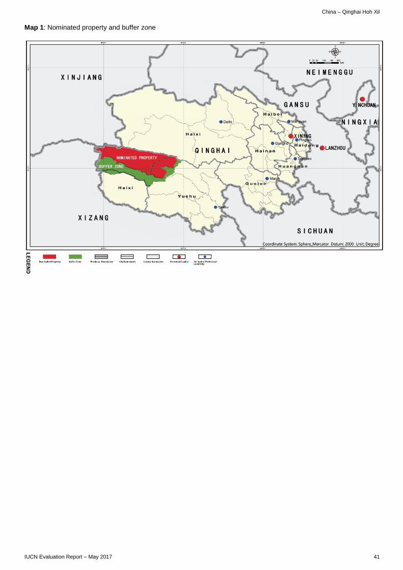
China – Qinghai Hoh Xil
Map 1: Nominated property and buffer zone
IUCN Evaluation Report – May 2017 41

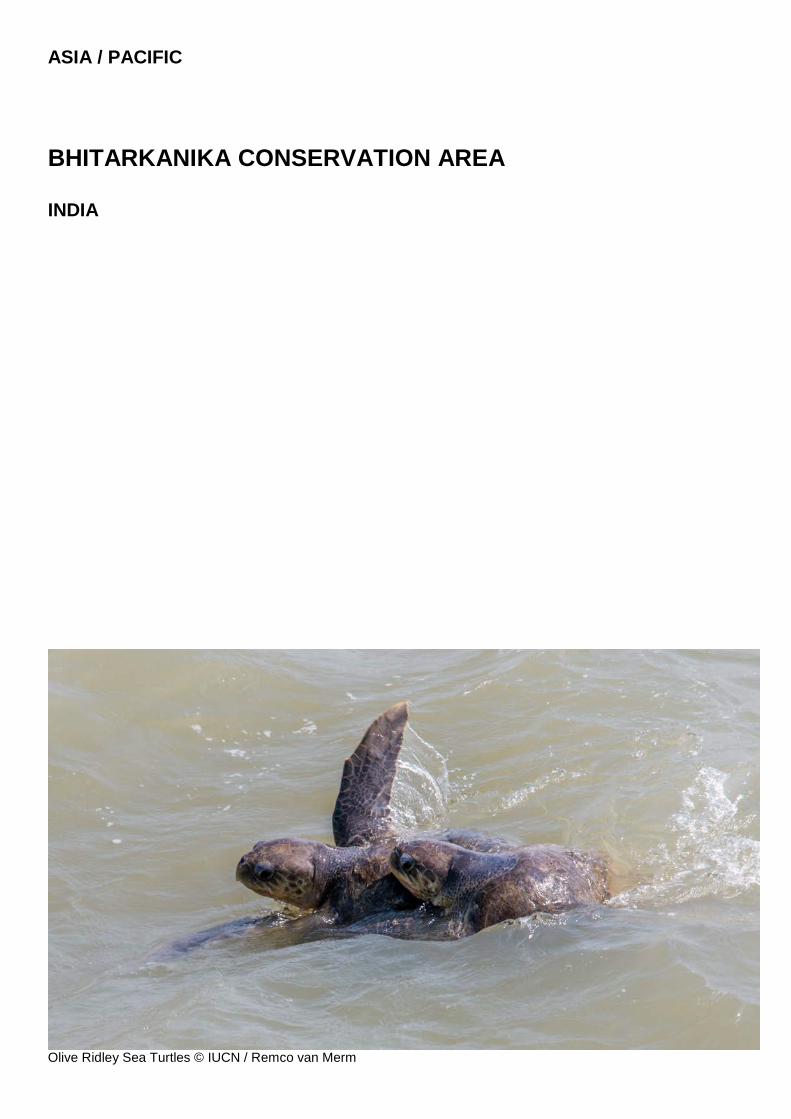
ASIA / PACIFIC
BHITARKANIKA CONSERVATION AREA INDIA
Olive Ridley Sea Turtles © IUCN / Remco van Merm

India - Bhitarkanika Conservation Area
WORLD HERITAGE NOMINATION – IUCN TECHNICAL EVALUATION
BHITARKANIKA CONSERVATION AREA (INDIA) – ID N° 1530
IUCN RECOMMENDATION TO WORLD HERITAGE COMMITTEE: Not to inscribe the property under natural criteria. Key paragraphs of Operational Guidelines: Paragraph 77: Nominated property does not meet World Heritage criteria. Paragraph 78: Nominated property does not meet integrity, protection and management requirements. 1. DOCUMENTATION a) Date nomination received by IUCN: 24 March 2016 b) Additional information officially requested from and provided by the State Party: Following the IUCN World Heritage Panel a progress report was sent to the State Party on 20 December 2016. The letter advised the State Party that, at the time of writing, it was not immediately clear that the natural criteria were met in the nomination and that further research would need to be undertaken within IUCN expert networks to further evaluate this. The letter also noted significant concerns regarding the integrity of the nominated property, including its boundary configuration. In addition, the letter requested more specific information on a range of issues including the potential impact of the Dhamra Port; measures and safeguards with respect to hazardous material spills; measures and safeguards to prevent impact from the missile testing facility on Wheeler Island (renamed in 2015 as Dr. Abdul Kalam Island); and more information on monitoring programmes with respect to climate change impacts. The State Party was also asked to clarify the reported relocation of two villages from the property including how consent for relocation was being assured. The information in response from the State Party was received by the World Heritage Centre on 21 February 2017. c) Additional literature consulted: Various sources including: Dhamra Port expansion. http://www.business-standard.com/article/companies/dhamra-port-kicks-off-work-on-expansion-116042700836_1.html (April 2016 news story) Accessed 01 March 2017. The New Indian Express news story 02 March 2017 Missile tests reduce chances of turtles return to Gahiramatha: Environmentalist. http://www.newindianexpress.com/states/odisha/2017/mar/02/missile-tests-reduce-chances-of-turtles-return-to-gahiramatha-environmentalist-1576570.html. Accessed 07 March 2017. C. Giri, E. Ochieng, L. L.Tieszen, Z. Zhu, A. Singh, T. Loveland, J. Masek and N. Duke. Status and distribution of mangrove forests of the world using earth observation satellite data. Glogal Ecology and Biogeography (2011) Volume 20, pages 154-159. K.R. Ambastha, S. A. Hussain, R. Badola and, P.S. Roy. Spatial analysis of anthropogenic disturbances in mangrove forests of the Bhitarkanika Conservation Area, India. Journal of the
Indian Society of Remote Sensing (March 2010) Volume 38 pages 67-83. Abreu-Grobois A. and Plotkin P. IUCN SSC Marine Turtle Specialist Group. 2008. Lepidochelys olivacea. The IUCN Red List of Threatened Species 2008: e.T11534A3292503. Behera S., Tripathy B., and Choudhury B.C. 2014. World’s largest Olive Ridley turtles Lepidochelys olivacea nesting grounds: Gahirmatha rookery now uncertain for arribada in future, East-Coast of India. The Herpetological Bulletin 130: 18-20. Barik, K.K., Mitra D., Annadurai R., Tripathy J. K., and Nanda S. 2016. Geospatial analysis of coastal environment: A case study on Bhitarkanika Mangroves, East coast of India. Indian Journal of Geo-Marine Sciences 45(4): 492-498. BirdLife International (2016) Important Bird Areas factsheet: Bhitarkanika Wildlife Sanctuary and National Park. Gopi G.V., and Pandav B. 2007. Avifauna of Bhitarkanika. Zoos Print Journal 22(10): 2839-3847. Jena S.C., Palita S.K., and Mahapatra M.K. 2013. Anurans of Bhitarkanika mangroves, Odisha, east coast of India. Check List 9(2): 400-404. Mishra P.K., Sahu J.R. and Upadhyay V.P. 2005. Species diversity in Bhitarkanika Mangrove ecosystem in Orissa, India. Lyonia 8(1): 73-87. Panda S.P., Subudhi H.N., Sahu A.K., Swain K.K. and Biswal M. 2014. Vanda tessellata (Roxb.) Hook. ex G. Don (Orchidaceae) an addition to the Flora of Bhitarkanika National Park, Odisha, India. International Journal of Innovative and Applied Research 2(5): 1-5. Pandav B., and Choudhury B.C. 2006. Migration and Movement of Olive Ridleys along the East Coast of India. In Shanker K., and Choudury B.C. (Eds) Marine Turtles of the Indian Subcontinent. Hyderabad, India: Universities Press: 365-379. Prasad Behera D., and Lakshman N. 2013. Floral Diversity of Bhitarkanika, East Coast of India and its potential uses. Journal of Chemical, Biological and Physical Sciences 3(3): 1863-1874. Spalding M., Kainuma M., and Collins L. 2010. World atlas of mangroves. A collaborative project of ITTO, ISME, FAO, UNEP-WCMC, UNESCO-MAB, UNU-INWEH and TNC. Earthscan, London (UK). Tripathy B. 2002. Is Gahirmatha the world’s largest sea turtle rookery? Current Science 83(11): 1299. Wallace B.P., DiMatteo A.D., Bolten A.B. et al. 2001. Global Conservation Priorities for Marine Turtles. PLoS ONE 6(9): e24510. India State of Forest Report,2015 published by Ministry of Environment and Forests. Mandal and Naskar,2008. Diversity and classification of Indian mangroves: a review. Tropical Ecology 49(2):131-146. Manual of Indian Mangroves by Kumudranjan Naskar by Daya Publishing House Delhi in 2004. Ecology of Mangrove swamps of Andaman
IUCN Evaluation Report – May 2017 45
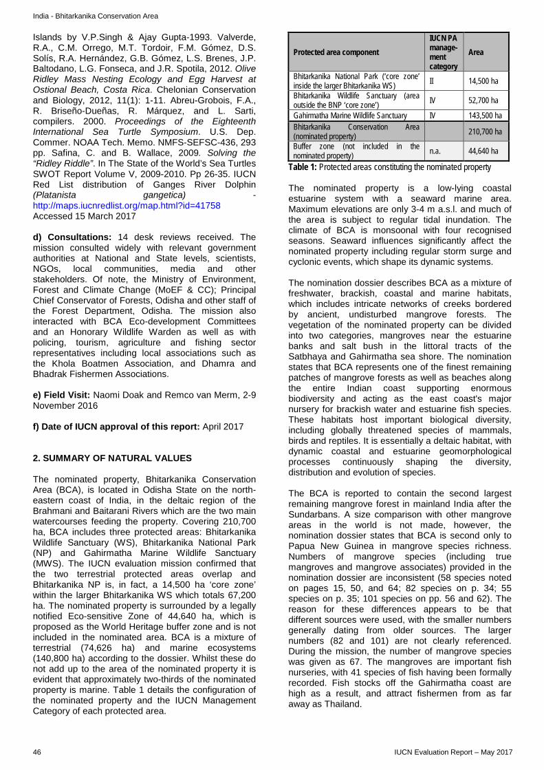
India - Bhitarkanika Conservation Area
Islands by V.P.Singh & Ajay Gupta-1993. Valverde, R.A., C.M. Orrego, M.T. Tordoir, F.M. Gómez, D.S. Solís, R.A. Hernández, G.B. Gómez, L.S. Brenes, J.P. Baltodano, L.G. Fonseca, and J.R. Spotila, 2012. Olive Ridley Mass Nesting Ecology and Egg Harvest at Ostional Beach, Costa Rica. Chelonian Conservation and Biology, 2012, 11(1): 1-11. Abreu-Grobois, F.A., R. Briseño-Dueñas, R. Márquez, and L. Sarti, compilers. 2000. Proceedings of the Eighteenth International Sea Turtle Symposium. U.S. Dep. Commer. NOAA Tech. Memo. NMFS-SEFSC-436, 293 pp. Safina, C. and B. Wallace, 2009. Solving the “Ridley Riddle”. In The State of the World’s Sea Turtles SWOT Report Volume V, 2009-2010. Pp 26-35. IUCN Red List distribution of Ganges River Dolphin (Platanista gangetica) - http://maps.iucnredlist.org/map.html?id=41758 Accessed 15 March 2017 d) Consultations: 14 desk reviews received. The mission consulted widely with relevant government authorities at National and State levels, scientists, NGOs, local communities, media and other stakeholders. Of note, the Ministry of Environment, Forest and Climate Change (MoEF & CC); Principal Chief Conservator of Forests, Odisha and other staff of the Forest Department, Odisha. The mission also interacted with BCA Eco-development Committees and an Honorary Wildlife Warden as well as with policing, tourism, agriculture and fishing sector representatives including local associations such as the Khola Boatmen Association, and Dhamra and Bhadrak Fishermen Associations. e) Field Visit: Naomi Doak and Remco van Merm, 2-9 November 2016 f) Date of IUCN approval of this report: April 2017 2. SUMMARY OF NATURAL VALUES The nominated property, Bhitarkanika Conservation Area (BCA), is located in Odisha State on the north-eastern coast of India, in the deltaic region of the Brahmani and Baitarani Rivers which are the two main watercourses feeding the property. Covering 210,700 ha, BCA includes three protected areas: Bhitarkanika Wildlife Sanctuary (WS), Bhitarkanika National Park (NP) and Gahirmatha Marine Wildlife Sanctuary (MWS). The IUCN evaluation mission confirmed that the two terrestrial protected areas overlap and Bhitarkanika NP is, in fact, a 14,500 ha ‘core zone’ within the larger Bhitarkanika WS which totals 67,200 ha. The nominated property is surrounded by a legally notified Eco-sensitive Zone of 44,640 ha, which is proposed as the World Heritage buffer zone and is not included in the nominated area. BCA is a mixture of terrestrial (74,626 ha) and marine ecosystems (140,800 ha) according to the dossier. Whilst these do not add up to the area of the nominated property it is evident that approximately two-thirds of the nominated property is marine. Table 1 details the configuration of the nominated property and the IUCN Management Category of each protected area.
Protected area component IUCN PA manage-ment category
Area
Bhitarkanika National Park (‘core zone’ inside the larger Bhitarkanika WS) II 14,500 ha
Bhitarkanika Wildlife Sanctuary (area outside the BNP ‘core zone’) IV 52,700 ha
Gahirmatha Marine Wildlife Sanctuary IV 143,500 ha Bhitarkanika Conservation Area (nominated property) 210,700 ha
Buffer zone (not included in the nominated property) n.a. 44,640 ha
Table 1: Protected areas constituting the nominated property The nominated property is a low-lying coastal estuarine system with a seaward marine area. Maximum elevations are only 3-4 m a.s.l. and much of the area is subject to regular tidal inundation. The climate of BCA is monsoonal with four recognised seasons. Seaward influences significantly affect the nominated property including regular storm surge and cyclonic events, which shape its dynamic systems. The nomination dossier describes BCA as a mixture of freshwater, brackish, coastal and marine habitats, which includes intricate networks of creeks bordered by ancient, undisturbed mangrove forests. The vegetation of the nominated property can be divided into two categories, mangroves near the estuarine banks and salt bush in the littoral tracts of the Satbhaya and Gahirmatha sea shore. The nomination states that BCA represents one of the finest remaining patches of mangrove forests as well as beaches along the entire Indian coast supporting enormous biodiversity and acting as the east coast's major nursery for brackish water and estuarine fish species. These habitats host important biological diversity, including globally threatened species of mammals, birds and reptiles. It is essentially a deltaic habitat, with dynamic coastal and estuarine geomorphological processes continuously shaping the diversity, distribution and evolution of species. The BCA is reported to contain the second largest remaining mangrove forest in mainland India after the Sundarbans. A size comparison with other mangrove areas in the world is not made, however, the nomination dossier states that BCA is second only to Papua New Guinea in mangrove species richness. Numbers of mangrove species (including true mangroves and mangrove associates) provided in the nomination dossier are inconsistent (58 species noted on pages 15, 50, and 64; 82 species on p. 34; 55 species on p. 35; 101 species on pp. 56 and 62). The reason for these differences appears to be that different sources were used, with the smaller numbers generally dating from older sources. The larger numbers (82 and 101) are not clearly referenced. During the mission, the number of mangrove species was given as 67. The mangroves are important fish nurseries, with 41 species of fish having been formally recorded. Fish stocks off the Gahirmatha coast are high as a result, and attract fishermen from as far away as Thailand.
46 IUCN Evaluation Report – May 2017
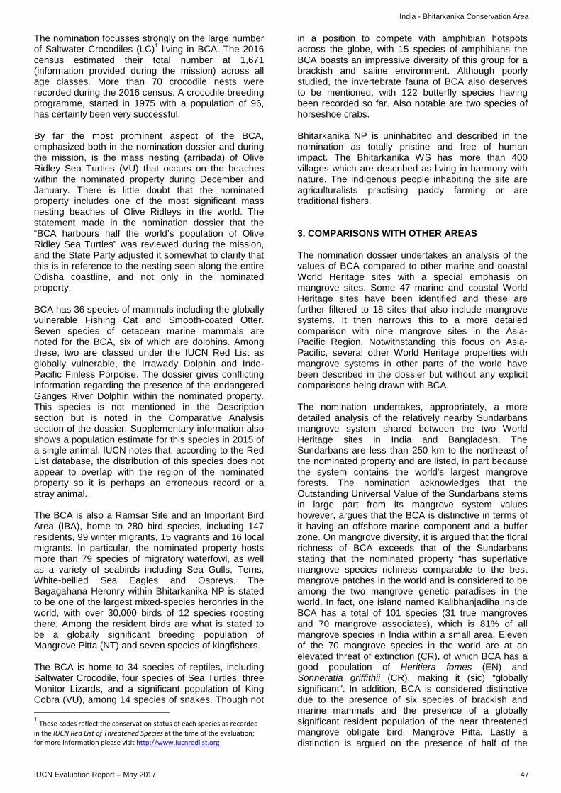
India - Bhitarkanika Conservation Area
The nomination focusses strongly on the large number of Saltwater Crocodiles (LC)1 living in BCA. The 2016 census estimated their total number at 1,671 (information provided during the mission) across all age classes. More than 70 crocodile nests were recorded during the 2016 census. A crocodile breeding programme, started in 1975 with a population of 96, has certainly been very successful. By far the most prominent aspect of the BCA, emphasized both in the nomination dossier and during the mission, is the mass nesting (arribada) of Olive Ridley Sea Turtles (VU) that occurs on the beaches within the nominated property during December and January. There is little doubt that the nominated property includes one of the most significant mass nesting beaches of Olive Ridleys in the world. The statement made in the nomination dossier that the “BCA harbours half the world’s population of Olive Ridley Sea Turtles” was reviewed during the mission, and the State Party adjusted it somewhat to clarify that this is in reference to the nesting seen along the entire Odisha coastline, and not only in the nominated property. BCA has 36 species of mammals including the globally vulnerable Fishing Cat and Smooth-coated Otter. Seven species of cetacean marine mammals are noted for the BCA, six of which are dolphins. Among these, two are classed under the IUCN Red List as globally vulnerable, the Irrawady Dolphin and Indo-Pacific Finless Porpoise. The dossier gives conflicting information regarding the presence of the endangered Ganges River Dolphin within the nominated property. This species is not mentioned in the Description section but is noted in the Comparative Analysis section of the dossier. Supplementary information also shows a population estimate for this species in 2015 of a single animal. IUCN notes that, according to the Red List database, the distribution of this species does not appear to overlap with the region of the nominated property so it is perhaps an erroneous record or a stray animal. The BCA is also a Ramsar Site and an Important Bird Area (IBA), home to 280 bird species, including 147 residents, 99 winter migrants, 15 vagrants and 16 local migrants. In particular, the nominated property hosts more than 79 species of migratory waterfowl, as well as a variety of seabirds including Sea Gulls, Terns, White-bellied Sea Eagles and Ospreys. The Bagagahana Heronry within Bhitarkanika NP is stated to be one of the largest mixed-species heronries in the world, with over 30,000 birds of 12 species roosting there. Among the resident birds are what is stated to be a globally significant breeding population of Mangrove Pitta (NT) and seven species of kingfishers. The BCA is home to 34 species of reptiles, including Saltwater Crocodile, four species of Sea Turtles, three Monitor Lizards, and a significant population of King Cobra (VU), among 14 species of snakes. Though not
1 These codes reflect the conservation status of each species as recorded in the IUCN Red List of Threatened Species at the time of the evaluation; for more information please visit http://www.iucnredlist.org
in a position to compete with amphibian hotspots across the globe, with 15 species of amphibians the BCA boasts an impressive diversity of this group for a brackish and saline environment. Although poorly studied, the invertebrate fauna of BCA also deserves to be mentioned, with 122 butterfly species having been recorded so far. Also notable are two species of horseshoe crabs. Bhitarkanika NP is uninhabited and described in the nomination as totally pristine and free of human impact. The Bhitarkanika WS has more than 400 villages which are described as living in harmony with nature. The indigenous people inhabiting the site are agriculturalists practising paddy farming or are traditional fishers. 3. COMPARISONS WITH OTHER AREAS The nomination dossier undertakes an analysis of the values of BCA compared to other marine and coastal World Heritage sites with a special emphasis on mangrove sites. Some 47 marine and coastal World Heritage sites have been identified and these are further filtered to 18 sites that also include mangrove systems. It then narrows this to a more detailed comparison with nine mangrove sites in the Asia-Pacific Region. Notwithstanding this focus on Asia-Pacific, several other World Heritage properties with mangrove systems in other parts of the world have been described in the dossier but without any explicit comparisons being drawn with BCA. The nomination undertakes, appropriately, a more detailed analysis of the relatively nearby Sundarbans mangrove system shared between the two World Heritage sites in India and Bangladesh. The Sundarbans are less than 250 km to the northeast of the nominated property and are listed, in part because the system contains the world's largest mangrove forests. The nomination acknowledges that the Outstanding Universal Value of the Sundarbans stems in large part from its mangrove system values however, argues that the BCA is distinctive in terms of it having an offshore marine component and a buffer zone. On mangrove diversity, it is argued that the floral richness of BCA exceeds that of the Sundarbans stating that the nominated property “has superlative mangrove species richness comparable to the best mangrove patches in the world and is considered to be among the two mangrove genetic paradises in the world. In fact, one island named Kalibhanjadiha inside BCA has a total of 101 species (31 true mangroves and 70 mangrove associates), which is 81% of all mangrove species in India within a small area. Eleven of the 70 mangrove species in the world are at an elevated threat of extinction (CR), of which BCA has a good population of Heritiera fomes (EN) and Sonneratia griffithii (CR), making it (sic) “globally significant”. In addition, BCA is considered distinctive due to the presence of six species of brackish and marine mammals and the presence of a globally significant resident population of the near threatened mangrove obligate bird, Mangrove Pitta. Lastly a distinction is argued on the presence of half of the
IUCN Evaluation Report – May 2017 47
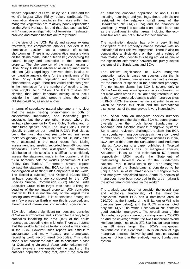
India - Bhitarkanika Conservation Area
world’s population of Olive Ridley Sea Turtles and the world’s largest Olive Ridley rookery (arribada). The nomination dossier concludes that sites with intact mangrove vegetation are relatively poorly represented on the World Heritage list and that sites such as BCA with “a unique amalgamation of terrestrial, freshwater, brackish and marine habitats are rarely found.” In the view of the IUCN Panel, and several external reviewers, the comparative analysis included in the nomination dossier has a number of serious shortcomings. There is no comparative analysis done on the claims made under criterion (vii) concerning the natural beauty and aesthetics of the nominated property. The phenomenon of the mass nesting of Olive Ridley Turtles is advanced as an argument under criterion (vii). Surprisingly however, there is also no comparative analysis done for the significance of the Olive Ridley Turtle population and the arribada phenomenon. Again, there are varied estimates given in the nomination for the numbers of nesting turtles, from 400,000 to 1 million. The IUCN mission also clarified that other important nesting sites occur outside the nominated property along the entire Odisha coastline, as noted above. In terms of superlative natural phenomena it is clear that the mass nesting phenomenon is both of conservation importance, and fascinating great spectacle, but there are other places where the arribada phenomenon for Olive Ridley Turtles, and for other turtle species, occur. The Olive Ridley Turtle is globally threatened but noted in IUCN’s Red List as being the most abundant sea turtle with numerous rookeries globally (data is scarce but 28 index sites were assessed in the most recent Red Listing assessment and nesting recorded from 60 countries worldwide). Given the widespread circumtropical distribution of this species it is difficult to confidently assess the statement made in the dossier that the “BCA harbours half the world’s population of Olive Ridley Sea Turtles.” Furthermore several experts contest the statement that BCA contains the largest congregation of nesting turtles anywhere in the world. The Escobilla (México) and Ostional (Costa Rica) arribada populations are considered by the IUCN Species Survival Commission (SSC) Marine Turtle Specialist Group to be larger than those utilizing the beaches of the nominated property. IUCN concludes that whilst BCA is not the only or the largest mass nesting area worldwide, it is nonetheless among the very few places on Earth where this is observed, and therefore is of international conservation significance. BCA also harbours significant numbers and densities of Saltwater Crocodiles and is known for the very large crocodiles inhabiting the area (10% of the adults reported as exceeding 6m in length). There are reports that the world's largest saltwater crocodile was found in the BCA. However, such reports are difficult to substantiate and many hoaxes are promulgated regarding world record sized crocodiles. This value alone is not considered adequate to constitute a case for Outstanding Universal Value under criterion (vii). Some reviewers have questioned the viability of the crocodile population noting that, even if the area has
an estuarine crocodile population of about 1,600 including hatchlings and yearlings, these animals are restricted to the relatively small area of the Bhitarkanika NP (14,500 ha) and the chances of yearlings growing into sub-adults and adults is remote as the conditions in other areas, including the eco-sensitive area, are not suitable for their survival. The nomination dossier has only a very limited description of the property’s marine systems with no indication of their relative importance. There is also no comparative analysis done on the marine values of Gahirmatha MWS despite this being argued as one of the significant differences between the purely deltaic systems of the Sundarbans and BCA. The relative significance of BCA’s mangrove vegetation value is based on species data that is variable (six different numbers are given in the dossier for the number of species in the nominated property). The nomination claims that BCA is second only to Papua New Guinea in mangrove species richness. It is not clear which areas in PNG are being referred to, nor is there any comparative analysis with mangrove sites in PNG. IUCN therefore has no evidential basis on which to assess this claim and the international distinctiveness of the mangroves is very inconclusive. The unclear data on mangrove species numbers throws doubt onto the claim that BCA harbours greater diversity than the much larger Sundarbans or Andaman and Nicobar Islands’ mangrove systems. Some expert reviewers challenge the claim that BCA has superlative mangrove species richness compared to other sites. In terms of mangrove richness in India, BCA comes third after the Sundarbans and Andaman Islands. According to a paper published in Tropical Ecology, Sundarbans has 69 mangrove species, Andaman Islands 61 and Bhitarkanika 57 species respectively. IUCN recalls the Statement of Outstanding Universal Value for the Sundarbans National Park in India states that “The mangrove ecosystem of the Sundarbans is considered to be unique because of its immensely rich mangrove flora and mangrove-associated fauna. Some 78 species of mangroves have been recorded in the area making it the richest mangrove forest in the world.” The analysis also does not consider the overall size and ecological functionality of the mangrove ecosystem. Whilst BCA has a nominated area of 210,700 ha, the integrity of the Bhitarkanika WS is in question (see below), and the IUCN mission noted only the 14,500 ha within Bhitarkanika NP contains good condition mangroves. The overall area of the Sundarbans system covered by mangroves is 700,000 ha and the coverage within the two Sundarbans World Heritage properties totals 272,510 ha, an area more than 18 times larger than BCA’s mangroves. Nevertheless it is clear that BCA is an area of high mangrove species biodiversity and contains several species not found in the relatively nearby Sundarbans system.
48 IUCN Evaluation Report – May 2017
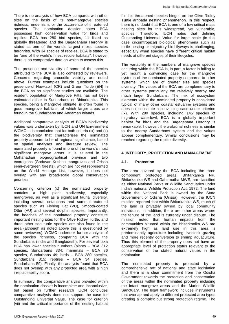
India - Bhitarkanika Conservation Area
There is no analysis of how BCA compares with other sites on the basis of its non-mangrove species richness, endemism, or the occurrence of threatened species. The nomination dossier notes BCA possesses high conservation value for birds and reptiles. BCA has 280 bird species, 11 listed as globally threatened and the Bagagahana Heronry is stated as one of the world’s largest mixed species heronries. With 34 species of reptiles, BCA is stated to be “one of the world’s finest reptile habitats”; however there is no comparative data on which to assess this. The presence and viability of some of the species attributed to the BCA is also contested by reviewers. Concerns regarding crocodile viability are noted above. Further examples include questions on the presence of Hawksbill (CR) and Green Turtle (EN) in the BCA as no significant studies are available. The resident population of Mangrove Pitta has not been estimated either in Sundarbans or Bhitarkanika. This species, being a mangrove obligate, is often found in good mangrove habitats, of which larger areas are found in the Sundarbans and Andaman Islands. Additional comparative analysis of BCA’s biodiversity values was undertaken by IUCN and UN Environment WCMC. It is concluded that for both criteria (ix) and (x) the biodiversity that characterises the nominated property appears to be of regional significance, based on spatial analyses and literature review. The nominated property is found in one of the world’s most significant mangrove areas. It is situated in the Mahanadian biogeographical province and two ecoregions (Godavari-Krishna mangroves and Orissa semi-evergreen forests), which are not yet represented on the World Heritage List, however, it does not overlap with any broad-scale global conservation priorities. Concerning criterion (x) the nominated property contains a high plant biodiversity, especially mangroves, as well as a significant faunal diversity, including several cetaceans and some threatened species such as Fishing Cat (VU), Smooth-coated Otter (VU) and several dolphin species. Importantly, the beaches of the nominated property constitute important nesting sites for the Olive Ridley Turtle, and three other sea turtle species are also found in the area (although as noted above this is questioned by some reviewers). WCMC undertook further analysis of the species richness, comparing BCA with the Sundarbans (India and Bangladesh). For several taxa BCA has lower species numbers (plants – BCA 312 species, Sundarbans 334; mammals – BCA 36 species, Sundarbans 49; birds – BCA 280 species, Sundarbans 315; reptiles – BCA 34 species, Sundarbans 59). Finally, the analysis found that BCA does not overlap with any protected area with a high irreplaceability score. In summary, the comparative analysis provided within the nomination dossier is incomplete and inconclusive, but based on further research IUCN concludes comparative analysis does not support the case for Outstanding Universal Value. The case for criterion (vii) and the critical importance of the nesting habitat
for this threatened species hinges on the Olive Ridley Turtle arribada nesting phenomenon. In this respect, there is no doubt that BCA is one of a few critical mass nesting sites for this widespread, yet vulnerable, species. Therefore, IUCN notes that defining Outstanding Universal Value for large scale (in this case circumtropical) biological phenomena such as turtle nesting or migratory bird flyways is challenging, especially when species have different critical habitat needs at different stages of their lifecycles. The variability in the numbers of mangrove species occurring within the BCA is, in part, a factor in failing to yet mount a convincing case for the mangrove systems of the nominated property compared to other systems, which are of greater size and species diversity. The values of the BCA are complementary to other systems particularly the relatively nearby and much larger Sundarbans. The mix of ecosystem elements within the nominated property is considered typical of many other coastal estuarine systems and does not constitute a convincing case under criterion (ix). With 280 species, including 145 species of migratory waterfowl, BCA is a globally important habitat for birds and the Bagagahana Heronry is remarkable; however, the avifaunal richness is similar to the nearby Sundarbans system and the values appear complementary. Similar conclusions may be reached regarding the reptile diversity. 4. INTEGRITY, PROTECTION AND MANAGEMENT 4.1. Protection The area covered by the BCA including the three component protected areas, Bhitarkanika NP, Bhitarkanika WS and Gahirmatha MWS, are classified as either National Parks or Wildlife Sanctuaries under India’s national Wildlife Protection Act, 1972. The land within the National Park is owned by the State Government of Odisha (Orissa). However, the IUCN mission reported that within Bhitarkanika WS, much of the land is privately owned by local community individuals. In addition, there are other areas where the tenure of the land is currently under dispute. The mission noted that human impacts from the communities situated within the Bhitarkanika WS are extremely high as land use in this area is predominantly agriculture including livestock grazing and more recently conversion to shrimp aquaculture. Thus this element of the property does not have an appropriate level of protection status relevant to the conservation of the stated natural values in the nomination. The nominated property is protected by a comprehensive raft of national and state legislation and there is a clear commitment from the Odisha Government towards the protection and conservation of the areas within the nominated property including the intact mangrove areas and the Marine Wildlife Sanctuary. The legal framework includes instruments that overlap and apply to different protected area types creating a complex but strong protection regime. The
IUCN Evaluation Report – May 2017 49
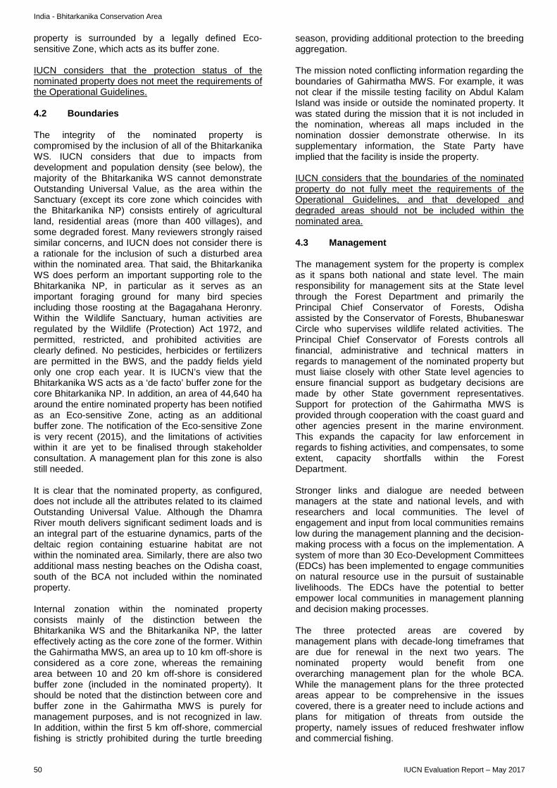
India - Bhitarkanika Conservation Area
property is surrounded by a legally defined Eco-sensitive Zone, which acts as its buffer zone. IUCN considers that the protection status of the nominated property does not meet the requirements of the Operational Guidelines. 4.2 Boundaries The integrity of the nominated property is compromised by the inclusion of all of the Bhitarkanika WS. IUCN considers that due to impacts from development and population density (see below), the majority of the Bhitarkanika WS cannot demonstrate Outstanding Universal Value, as the area within the Sanctuary (except its core zone which coincides with the Bhitarkanika NP) consists entirely of agricultural land, residential areas (more than 400 villages), and some degraded forest. Many reviewers strongly raised similar concerns, and IUCN does not consider there is a rationale for the inclusion of such a disturbed area within the nominated area. That said, the Bhitarkanika WS does perform an important supporting role to the Bhitarkanika NP, in particular as it serves as an important foraging ground for many bird species including those roosting at the Bagagahana Heronry. Within the Wildlife Sanctuary, human activities are regulated by the Wildlife (Protection) Act 1972, and permitted, restricted, and prohibited activities are clearly defined. No pesticides, herbicides or fertilizers are permitted in the BWS, and the paddy fields yield only one crop each year. It is IUCN’s view that the Bhitarkanika WS acts as a ‘de facto’ buffer zone for the core Bhitarkanika NP. In addition, an area of 44,640 ha around the entire nominated property has been notified as an Eco-sensitive Zone, acting as an additional buffer zone. The notification of the Eco-sensitive Zone is very recent (2015), and the limitations of activities within it are yet to be finalised through stakeholder consultation. A management plan for this zone is also still needed. It is clear that the nominated property, as configured, does not include all the attributes related to its claimed Outstanding Universal Value. Although the Dhamra River mouth delivers significant sediment loads and is an integral part of the estuarine dynamics, parts of the deltaic region containing estuarine habitat are not within the nominated area. Similarly, there are also two additional mass nesting beaches on the Odisha coast, south of the BCA not included within the nominated property. Internal zonation within the nominated property consists mainly of the distinction between the Bhitarkanika WS and the Bhitarkanika NP, the latter effectively acting as the core zone of the former. Within the Gahirmatha MWS, an area up to 10 km off-shore is considered as a core zone, whereas the remaining area between 10 and 20 km off-shore is considered buffer zone (included in the nominated property). It should be noted that the distinction between core and buffer zone in the Gahirmatha MWS is purely for management purposes, and is not recognized in law. In addition, within the first 5 km off-shore, commercial fishing is strictly prohibited during the turtle breeding
season, providing additional protection to the breeding aggregation. The mission noted conflicting information regarding the boundaries of Gahirmatha MWS. For example, it was not clear if the missile testing facility on Abdul Kalam Island was inside or outside the nominated property. It was stated during the mission that it is not included in the nomination, whereas all maps included in the nomination dossier demonstrate otherwise. In its supplementary information, the State Party have implied that the facility is inside the property. IUCN considers that the boundaries of the nominated property do not fully meet the requirements of the Operational Guidelines, and that developed and degraded areas should not be included within the nominated area. 4.3 Management The management system for the property is complex as it spans both national and state level. The main responsibility for management sits at the State level through the Forest Department and primarily the Principal Chief Conservator of Forests, Odisha assisted by the Conservator of Forests, Bhubaneswar Circle who supervises wildlife related activities. The Principal Chief Conservator of Forests controls all financial, administrative and technical matters in regards to management of the nominated property but must liaise closely with other State level agencies to ensure financial support as budgetary decisions are made by other State government representatives. Support for protection of the Gahirmatha MWS is provided through cooperation with the coast guard and other agencies present in the marine environment. This expands the capacity for law enforcement in regards to fishing activities, and compensates, to some extent, capacity shortfalls within the Forest Department. Stronger links and dialogue are needed between managers at the state and national levels, and with researchers and local communities. The level of engagement and input from local communities remains low during the management planning and the decision-making process with a focus on the implementation. A system of more than 30 Eco-Development Committees (EDCs) has been implemented to engage communities on natural resource use in the pursuit of sustainable livelihoods. The EDCs have the potential to better empower local communities in management planning and decision making processes. The three protected areas are covered by management plans with decade-long timeframes that are due for renewal in the next two years. The nominated property would benefit from one overarching management plan for the whole BCA. While the management plans for the three protected areas appear to be comprehensive in the issues covered, there is a greater need to include actions and plans for mitigation of threats from outside the property, namely issues of reduced freshwater inflow and commercial fishing.
50 IUCN Evaluation Report – May 2017
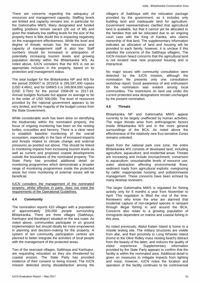
India - Bhitarkanika Conservation Area
There are concerns regarding the adequacy of resources and management capacity. Staffing levels are limited and capacity remains low, in particular for the Gahirmatha MWS. Many designated and funded staffing positions remain vacant (26 out of 98) and given the relatively low staffing levels for the size of the property there is little doubt this is impacting negatively on the management effectiveness. While the level and degree of threats remain low, the resources and capacity of management staff is also low. Staff numbers should be increased in anticipation of potentially increasing tourism levels and growing population density within the Bhitarkanika WS. As noted above, IUCN considers that the WS is not an appropriate inclusion in the property, based on its protection and management status. The total budget for the Bhitarkanika NP and WS for the period 2006/07 to 2015/16 is 295,597,400 rupees (USD 4.46m), and for GMWS it is 249,804,000 rupees (USD 3.75m) for the period 2008-09 to 2017-18. Annual budgets fluctuate but appear on average to be in the order of USD 500,000. The level of resources provided by the national government appears to be very limited, and the majority of the budget comes from the State Government. While considerable work has been done on identifying the biodiversity within the nominated property, the focus of ongoing monitoring has been on the nesting turtles, crocodiles and heronry. There is a clear need to establish baseline monitoring of the overall ecosystem, especially in the face of increased impacts and threats related to climate change and external pressures as pointed out above. This should be linked to monitoring impacts from increasing tourism levels as well as current and proposed coastal developments outside the boundaries of the nominated property. The State Party has provided additional detail on monitoring programmes which demonstrate a broader range of monitoring programmes inside the protected areas but more monitoring of external issues will be beneficial. IUCN considers the management of the nominated property, whilst effective in parts, does not meet the requirements of the Operational Guidelines. 4.4 Community The nomination reports 410 villages with a population of approximately 200,000 people surrounding Bhitarkanika. There are three villages (Satbhaya, Kanhupur and Barahipur) situated on the sea coast. As noted above, communities participate in on ground implementation but should ideally be more empowered in planning and decision-making for the property. A system of ten community participation centres are planned to better integrate the activities of local people with the management of the protected areas. Two of the seacoast villages, Satbhaya and Kanhupur, are requesting relocation as they are threatened by coastal erosion. The State Party has provided evidence of their consent to being moved. The IUCN mission detected strong dissatisfaction among the
villagers of Satbhaya with the relocation package provided by the government, as it includes only building land and inadequate land for agriculture. Government representatives clarified that agricultural land is available, but that it cannot yet be allocated to the families that will be relocated due to an ongoing court case with the King of Kanika, who claims ownership of that land. The supplementary information indicates an allocation of land and housing will be provided to each family, however, it is unclear if this satisfies the concerns of the Satbhaya villagers. The IUCN mission heard concerns that the agricultural land is not located near new proposed housing and is impractical. No major issues with community consultation were detected by the IUCN mission, although the nomination file presents only one consultation workshop report. Good awareness of and enthusiasm for the nomination was evident among local communities. The restrictions on land use under the current protected area designations remain unchanged by the present nomination. 4.5 Threats Bhitarkanika NP and Gahirmatha MWS appear currently to be largely unaffected by human activities. The major threats arise from anthropogenic factors inside Bhitarkanika WS and in the more general surroundings of the BCA. As noted above the effectiveness of the relatively new Eco-sensitive Zones remains untested. Apart from the national park core zone, the entire Bhitarkanika WS consists of developed land, including agriculture, aquaculture, and residential areas. Threats are increasing and include encroachment; conversion to aquaculture; unsustainable levels of resource use; water abstraction affecting environmental flows; sediment loads from agricultural exploits; overgrazing by cattle; inappropriate housing; and pollution/waste management. These concerns have been echoed by many desktop reviewers. The larger Gahirmatha MWS is regulated for fishing activity only for 6 months a year from November to April. This regulation is lifted the rest of the time. Reviewers who know the area are alarmed that incidental capture of non-targeted species is rampant through illegal fishing in and around the BCA. Concerns also relate to a growing population of immigrants dependent on marine and coastal fishing in this area. As noted previously, Abdul Kalam Island is home to a missile testing site. The military structures are visible from afar, and their proximity to Long Wheeler Island (home to the Olive Ridley mass nesting beach) distract from the beauty of the latter, and reduces the quality of visitor experience. Supplementary information provided by the State Party appears to confirm that the facility is within the nominated area. Additional detail is given on measures to mitigate impacts from lighting and noise; however, IUCN notes the location and operation of the facility continues to be controversial
IUCN Evaluation Report – May 2017 51
India - Bhitarkanika Conservation Area
with respect to turtle nesting impacts and missile tests are reported in news media to be conducted whilst turtles are nesting. A number of other existing or planned coastal developments appear to be threatening Olive Ridley Turtle nesting patterns along the Odisha coastline. The Dhamra Port just to the north of BCA was controversial when developed and is now subject to planned expansion that will reportedly quadruple cargo handling capacity to over 100 million tonnes a year. IUCN was provided with additional information from the State Party on monitoring and safeguards to protect turtle nesting from the Dhamra Port development. This extra detail provides some assurances, however, ongoing careful risk management will be needed to protect sensitive turtle nesting behaviour. Most of the monitoring is directed at the turtle nesting beaches and does not seem to assess broader impacts on the BCA such as water pollution near the mouth of the Dhamra River. The field mission noted plans to develop ports at every river mouth along the Odisha coast. Other reviewers have highlighted the impacts of coastal developments such as construction of a geo-tube sea wall along the coast at Pentha within the BCA as altering the beach profile, nesting beach for turtles and moisture content of sand. The embankment constructed near Gupti and many other areas to protect the inland villages from tidal inundation has reportedly affected the natural dynamics of water flow and the associated ecological processes. The evidence suggests escalating threats to Olive Ridley Turtle nesting patterns, which are becoming more irregular and fragmented. The nomination dossier indicates approximately 55,000 visitors to the BCA in 2014/15, the vast majority of whom are domestic. Tourism statistics are also provided from 2001/02 indicating a more than doubling of the numbers of visitors. Access into mangrove systems is often difficult with tourists restricted to discrete areas with visitor facilities. The current numbers overall and limited tourism footprint do not appear to be creating unacceptable impacts. Nevertheless, careful planning should be exercised to prevent unregulated tourism growth. In conclusion IUCN considers that, taken as a whole, the nominated property does not meet the integrity, protection or management requirements of the Operational Guidelines. 5. ADDITIONAL COMMENTS None. 6. APPLICATION OF CRITERIA Bhitarkanika Conservation Area has been nominated under natural criteria (vii), (ix) and (x).
Criterion (vii): Superlative natural phenomena or natural beauty or aesthetic importance The justification for this criterion as based on “breathtaking natural beauty” is not convincing. The wide range of coastal and marine habitats (virgin beaches, isolated offshore islands, wetlands hosting bird species and mangrove-lined creeks) does not stand out compared to similar sites across the world. The significant development that has taken place in the Bhitarkanika WS as well as the military facility on Abdul Kalam Island have a deleterious impact on the naturalness of the area and its aesthetic values. The justification for criterion (vii) related to the mass nesting (arribada) of Olive Ridley Turtle is also not compelling. According to the literature, two other major sites are known for this mass nesting: La Escobilla in Mexico and Ostional in Costa Rica. Although it is not proven that BCA is home to the largest Olive Ridley Turtle rookery in the world, it is clearly among the very few places on Earth where this natural phenomenon is observed. Other parts of the Odisha coastline are also important in what seem to be becoming more fragmented nesting patterns. Integrity, protection and management requirements to allow the application of this criterion are also not met. IUCN notes that the phenomenon of turtle nesting globally may well warrant further study in relation to the application of criterion (vii); however this needs further study to define what would constitute Outstanding Universal Value for such global scale phenomena. IUCN considers that the nominated property does not meet this criterion in its own right. Criterion (ix): Ecosystems/communities and ecological/biological processes The basis for Outstanding Universal Value under this criterion put forward by the nomination is not compelling. It is based upon the temporal and spatial changes to the habitat contours of BCA as a result of tidal action, lunar phases and consequent tidal surges, the prominent accretion and erosion of river banks and nutrient cycling as well as the diversity and evolution of species, and their distribution, which are shaped by the mentioned geomorphological processes. These changes are however typical of deltaic mangrove systems and occur in much larger scale in other similar sites such as the Sundarbans, parts of which are already inscribed on the World Heritage List. Moreover, the limited size of the intact parts of the BCA, and the exclusion of some of the deltaic system, is not likely sufficient to ensure the continued natural occurrence of these ecological processes in the long term. Furthermore, almost the entire Bhitarkanika WS, is subject to residential and intensive agricultural land use, which represents considerably more than half of the terrestrial area of the nominated property. The remaining terrestrial mangrove areas are thus small and not considered ecologically viable. Integrity, protection and management requirements are not met. IUCN considers that the nominated property does not meet this criterion.
52 IUCN Evaluation Report – May 2017

India - Bhitarkanika Conservation Area
Criterion (x): Biodiversity and threatened species Across all taxa, species richness is lower in the nominated property than the Sundarbans and the mangrove diversity is questioned when compared with other sites, even in India (Sundarbans and Andaman Islands). Whilst the mangrove values appear complementary to other mangrove systems, the ambiguity in the data on mangrove species numbers and the weakness in comparative analysis make it difficult to assess the extent of complementarity and distinctiveness with other mangrove systems. Furthermore, the nominated property does not meet the integrity requirements of the Operational Guidelines, specifically the areas of the Bhitarkanika WS which are heavily disturbed. If the Bhitarkanika WS is removed from the nominated area and acts as a buffer zone, the remaining good quality intertidal and terrestrial system becomes very small at 14,500 ha, and much smaller than other mangrove systems worldwide, including the closest comparator, the Sundarbans just 250 km to the northeast. The site is important for birds, however there is no comparative analysis given to justify how this criterion is met for birdlife, and the nearby Sundarbans are home to a larger number of bird species. The same is true for reptiles. IUCN concludes under criterion (x) that BCA is regionally significant but does not approach the biodiversity values needed to justify Outstanding Universal Value under this criterion. The integrity problems with large parts of the property again reduce its size and viability. However, it would add important complementary habitat to the extensive mangrove systems of the Sundarbans especially for distinctive mangrove species, birds, reptiles and amphibians. IUCN considers that the nominated property does not meet this criterion.
7. RECOMMENDATIONS IUCN recommends that the World Heritage Committee adopts the following draft decision: The World Heritage Committee, 1. Having examined Documents WHC/17/41.COM/8B and WHC/17/41.COM/INF.8B2; 2. Decides not to inscribe the Bhitarkanika Conservation Area (India) on the World Heritage List under natural criteria. 3. Recommends that the State Party of India:
a) ensures adequate human, material and financial resources to support the effective management of the Bhitarkanika Conservation Area, and in particular to provide adequate resources for the management of the Gahirmatha Marine Wildlife Sanctuary, including year-round patrolling to prevent illegal fishing by commercial fishing vessels;
b) implements additional protection for the two additional mass Olive Ridley Turtle nesting beaches on the Odisha Coast.
4. Thanks the State Party of India for its continued efforts to protect and conserve the values of the nominated property, including previous efforts to re-establish the Saltwater Crocodile population and to protect the Olive Ridley Turtle population and the nesting beach on the Gahirmatha Coast.
IUCN Evaluation Report – May 2017 53
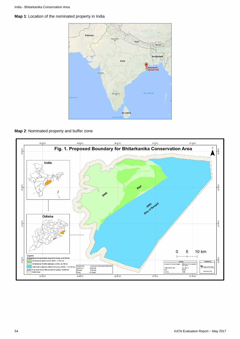
India - Bhitarkanika Conservation Area
Map 1: Location of the nominated property in India
Map 2: Nominated property and buffer zone
54 IUCN Evaluation Report – May 2017
EUROPE / NORTH AMERICA
PRIMEVAL BEECH FORESTS OF THE CARPATHIANS AND OTHER REGIONS OF EUROPE ALBANIA / AUSTRIA / BELGIUM / BULGARIA / CROATIA / ITALY / ROMANIA / SLOVENIA / SPAIN / UKRAINE
Mixed Beech Forest, Austria © IUCN / David Mihalic

Albania/Austria/Belgium/Bulgaria/Croatia/Italy/Romania/Slovenia/Spain/Ukraine – Primeval Beech Forests of the Carpathians and Other Regions of Europe
WORLD HERITAGE NOMINATION – IUCN TECHNICAL EVALUATION
PRIMEVAL BEECH FORESTS OF THE CARPATHIANS AND OTHER REGIONS OF EUROPE (ALBANIA / AUSTRIA / BELGIUM / BULGARIA / CROATIA / ITALY/ ROMANIA / SLOVENIA / SPAIN / UKRAINE) – ID N° 1133 Ter
IUCN RECOMMENDATION TO WORLD HERITAGE COMMITTEE: To defer the nomination under natural criteria. Key paragraphs of Operational Guidelines: Paragraph 77: Nominated extension does not meet World Heritage criteria, but some component parts would be appropriate for inclusion in revised proposals for extension of the presently inscribed property. Paragraph 78: Nominated property does not meet integrity, protection and management requirements. Background note: IUCN evaluated the Primeval Forests of Slovakia, nominated by Slovakia, as a serial natural property in 2003; however, the State Party withdrew the nomination and it was not discussed at the session of the World Heritage Committee (Suzhou, 2004). IUCN’s evaluation, at that time, highlighted the need for the States Parties of Slovakia and Ukraine to work together to better conserve the remaining beech forests. In 2006, the States Parties of Slovakia and Ukraine jointly submitted a new nomination for a transnational serial natural property of key remnants of their remaining Carpathian beech forests which was inscribed as the “Primeval Beech Forests of the Carpathians” in 2007 (Decision 31 COM 8B.16) after a positive IUCN recommendation. In 2010, the Ancient Beech Forests of Germany was nominated as a transnational serial extension of the above site in Slovakia and Ukraine. This nomination changed the scope of the Outstanding Universal Value to include ancient (rather than primeval) forests where past human activity had varying levels of prominence and in which historical forest use including logging, fuelwood collection, hunting and forest pasture had taken place. IUCN recommended deferral of this extension, but the World Heritage Committee approved the extension in 2011 creating an enlarged serial property shared across three countries and with a new name: Primeval Beech Forests of the Carpathians and the Ancient Beech Forests of Germany (Decision 35 COM 8B.13). In its Decision, the Committee encouraged the States Parties to “further these efforts by cooperating with the support of IUCN and the World Heritage Centre, with other interested States Parties towards a finite serial transnational nomination in order to assure the protection of this unique forest ecosystem.” The Committee’s attention is also drawn to IUCN’s previous evaluations of 2007 and 2011 (http://whc.unesco.org/en/list/1133/documents/) which contain relevant analysis, and to the fact that the current inscribed site is to be considered in relation to State of Conservation issues under item 7B of the agenda of the same meeting at which this nomination is being made. The Committee’s attention is also drawn to the fact that the nomination under consideration was originally made by a group of State Parties including Poland; however Poland withdrew its beech forest components from the nomination prior to IUCN’s evaluation. 1. DOCUMENTATION a) Date nomination received by IUCN: 24 March 2016 b) Additional information officially requested from and provided by the States Parties: Following the IUCN World Heritage Panel, a progress report was sent to the States Parties on 24 January 2017. This letter advised on the status of the evaluation process and highlighted a range of fundamental matters which arose from the Panel’s initial deliberations on the nomination. Issues raised included the conceptual rationale for the transnational extension and a trend in this nomination toward smaller, less viable components and buffer zones. Additional concerns included the configuration of the components and their buffer zones as well as the relationship of the nominated property with overlapping protected areas
and formal zoning systems. Several issues were also raised concerning protection and management including the additional protection and effectiveness afforded by the buffer zones; effectiveness of transnational coordination; proposed funding arrangements; and how the proposed extension would be integrated with the existing World Heritage property in Slovakia, Ukraine and Germany. A meeting between IUCN and technical representatives from Austria, Belgium, and Spain representing the nomination, was held, at the request of the State Parties, at IUCN’s Headquarters on 1st February, 2017. The meeting provided an opportunity to further elaborate on the progress report and clarify specific issues raised by the IUCN Panel. The States Parties provided additional information, received on 28 February 2017, in response to issues raised in the December letter and the February meeting.
IUCN Evaluation Report – May 2017 57
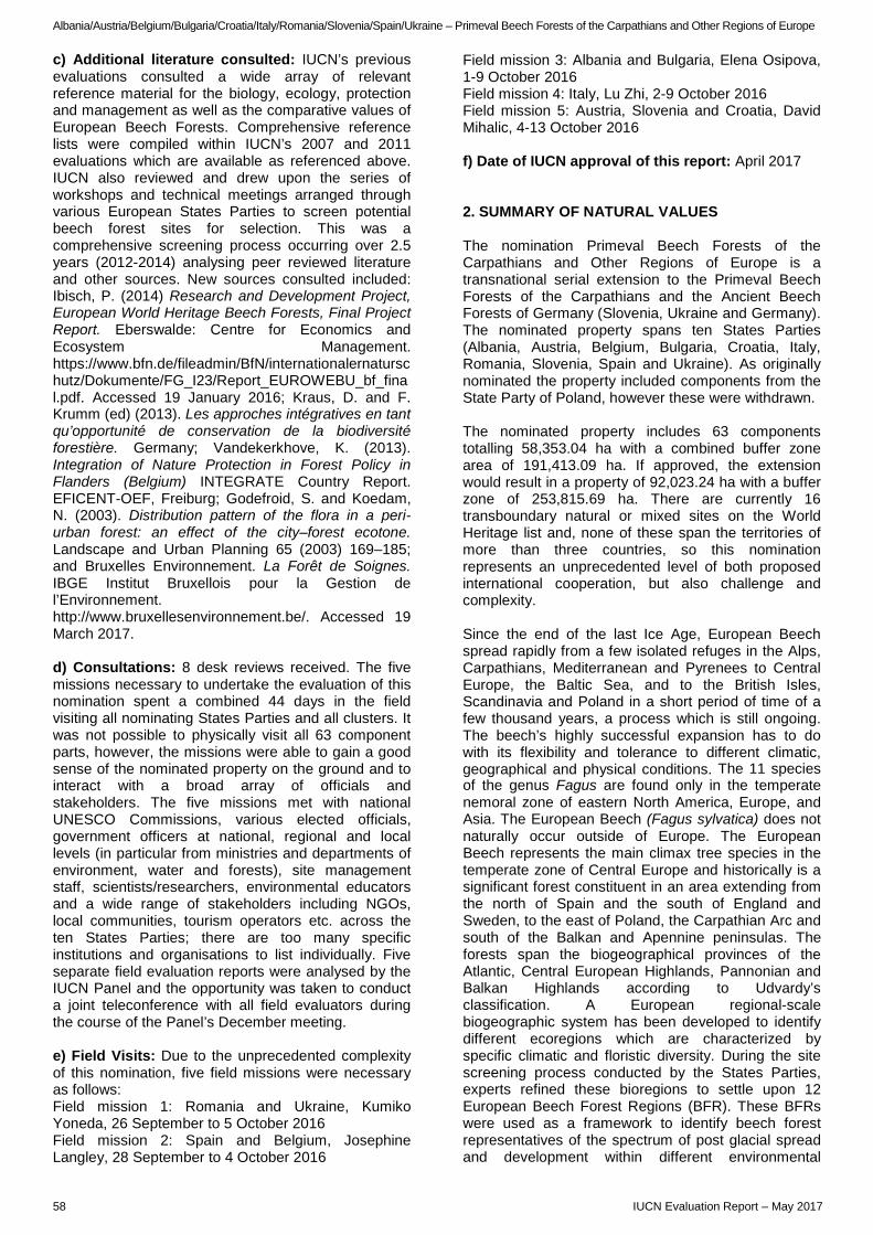
Albania/Austria/Belgium/Bulgaria/Croatia/Italy/Romania/Slovenia/Spain/Ukraine – Primeval Beech Forests of the Carpathians and Other Regions of Europe
c) Additional literature consulted: IUCN’s previous evaluations consulted a wide array of relevant reference material for the biology, ecology, protection and management as well as the comparative values of European Beech Forests. Comprehensive reference lists were compiled within IUCN’s 2007 and 2011 evaluations which are available as referenced above. IUCN also reviewed and drew upon the series of workshops and technical meetings arranged through various European States Parties to screen potential beech forest sites for selection. This was a comprehensive screening process occurring over 2.5 years (2012-2014) analysing peer reviewed literature and other sources. New sources consulted included: Ibisch, P. (2014) Research and Development Project, European World Heritage Beech Forests, Final Project Report. Eberswalde: Centre for Economics and Ecosystem Management. https://www.bfn.de/fileadmin/BfN/internationalernaturschutz/Dokumente/FG_I23/Report_EUROWEBU_bf_final.pdf. Accessed 19 January 2016; Kraus, D. and F. Krumm (ed) (2013). Les approches intégratives en tant qu’opportunité de conservation de la biodiversité forestière. Germany; Vandekerkhove, K. (2013). Integration of Nature Protection in Forest Policy in Flanders (Belgium) INTEGRATE Country Report. EFICENT-OEF, Freiburg; Godefroid, S. and Koedam, N. (2003). Distribution pattern of the flora in a peri-urban forest: an effect of the city–forest ecotone. Landscape and Urban Planning 65 (2003) 169–185; and Bruxelles Environnement. La Forêt de Soignes. IBGE Institut Bruxellois pour la Gestion de l’Environnement. http://www.bruxellesenvironnement.be/. Accessed 19 March 2017. d) Consultations: 8 desk reviews received. The five missions necessary to undertake the evaluation of this nomination spent a combined 44 days in the field visiting all nominating States Parties and all clusters. It was not possible to physically visit all 63 component parts, however, the missions were able to gain a good sense of the nominated property on the ground and to interact with a broad array of officials and stakeholders. The five missions met with national UNESCO Commissions, various elected officials, government officers at national, regional and local levels (in particular from ministries and departments of environment, water and forests), site management staff, scientists/researchers, environmental educators and a wide range of stakeholders including NGOs, local communities, tourism operators etc. across the ten States Parties; there are too many specific institutions and organisations to list individually. Five separate field evaluation reports were analysed by the IUCN Panel and the opportunity was taken to conduct a joint teleconference with all field evaluators during the course of the Panel’s December meeting. e) Field Visits: Due to the unprecedented complexity of this nomination, five field missions were necessary as follows: Field mission 1: Romania and Ukraine, Kumiko Yoneda, 26 September to 5 October 2016 Field mission 2: Spain and Belgium, Josephine Langley, 28 September to 4 October 2016
Field mission 3: Albania and Bulgaria, Elena Osipova, 1-9 October 2016 Field mission 4: Italy, Lu Zhi, 2-9 October 2016 Field mission 5: Austria, Slovenia and Croatia, David Mihalic, 4-13 October 2016 f) Date of IUCN approval of this report: April 2017 2. SUMMARY OF NATURAL VALUES The nomination Primeval Beech Forests of the Carpathians and Other Regions of Europe is a transnational serial extension to the Primeval Beech Forests of the Carpathians and the Ancient Beech Forests of Germany (Slovenia, Ukraine and Germany). The nominated property spans ten States Parties (Albania, Austria, Belgium, Bulgaria, Croatia, Italy, Romania, Slovenia, Spain and Ukraine). As originally nominated the property included components from the State Party of Poland, however these were withdrawn. The nominated property includes 63 components totalling 58,353.04 ha with a combined buffer zone area of 191,413.09 ha. If approved, the extension would result in a property of 92,023.24 ha with a buffer zone of 253,815.69 ha. There are currently 16 transboundary natural or mixed sites on the World Heritage list and, none of these span the territories of more than three countries, so this nomination represents an unprecedented level of both proposed international cooperation, but also challenge and complexity. Since the end of the last Ice Age, European Beech spread rapidly from a few isolated refuges in the Alps, Carpathians, Mediterranean and Pyrenees to Central Europe, the Baltic Sea, and to the British Isles, Scandinavia and Poland in a short period of time of a few thousand years, a process which is still ongoing. The beech’s highly successful expansion has to do with its flexibility and tolerance to different climatic, geographical and physical conditions. The 11 species of the genus Fagus are found only in the temperate nemoral zone of eastern North America, Europe, and Asia. The European Beech (Fagus sylvatica) does not naturally occur outside of Europe. The European Beech represents the main climax tree species in the temperate zone of Central Europe and historically is a significant forest constituent in an area extending from the north of Spain and the south of England and Sweden, to the east of Poland, the Carpathian Arc and south of the Balkan and Apennine peninsulas. The forests span the biogeographical provinces of the Atlantic, Central European Highlands, Pannonian and Balkan Highlands according to Udvardy’s classification. A European regional-scale biogeographic system has been developed to identify different ecoregions which are characterized by specific climatic and floristic diversity. During the site screening process conducted by the States Parties, experts refined these bioregions to settle upon 12 European Beech Forest Regions (BFR). These BFRs were used as a framework to identify beech forest representatives of the spectrum of post glacial spread and development within different environmental
58 IUCN Evaluation Report – May 2017
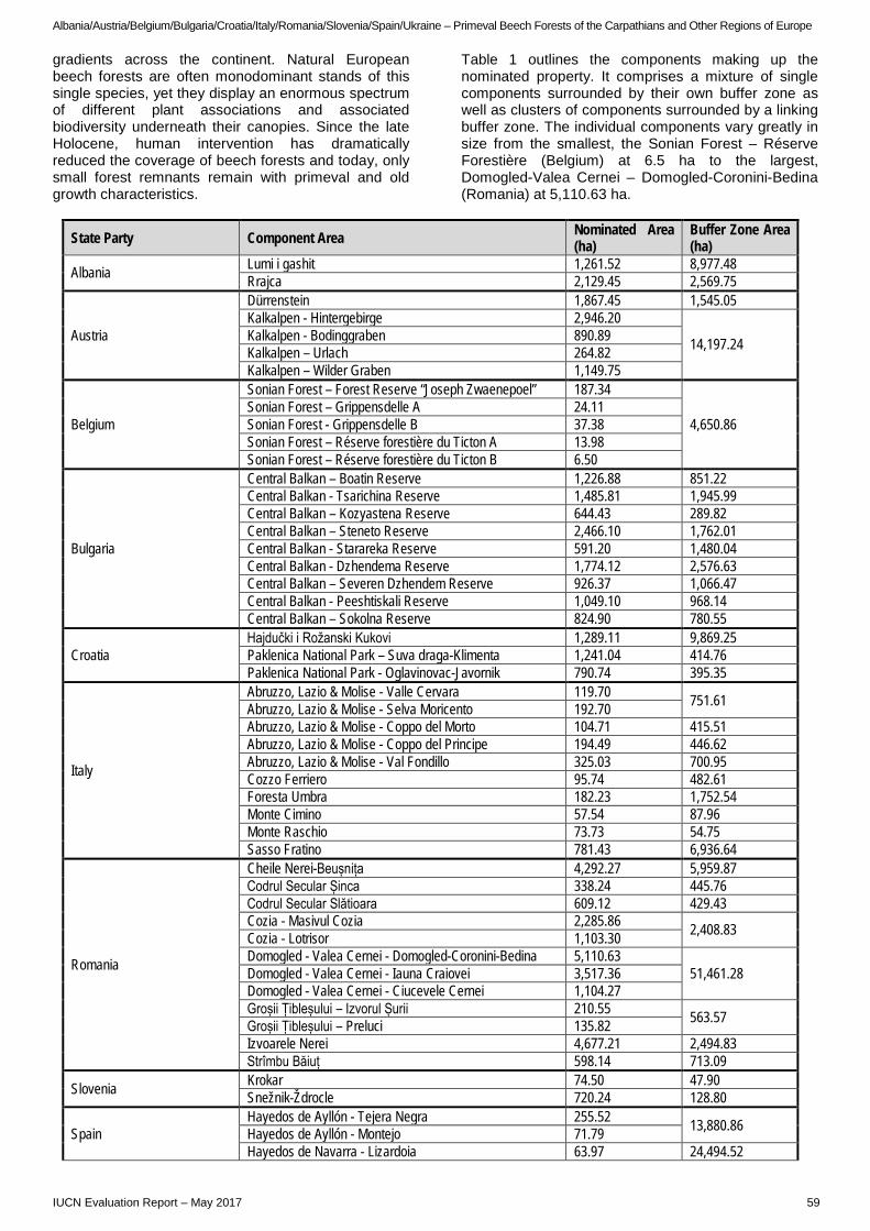
Albania/Austria/Belgium/Bulgaria/Croatia/Italy/Romania/Slovenia/Spain/Ukraine – Primeval Beech Forests of the Carpathians and Other Regions of Europe
gradients across the continent. Natural European beech forests are often monodominant stands of this single species, yet they display an enormous spectrum of different plant associations and associated biodiversity underneath their canopies. Since the late Holocene, human intervention has dramatically reduced the coverage of beech forests and today, only small forest remnants remain with primeval and old growth characteristics.
Table 1 outlines the components making up the nominated property. It comprises a mixture of single components surrounded by their own buffer zone as well as clusters of components surrounded by a linking buffer zone. The individual components vary greatly in size from the smallest, the Sonian Forest – Réserve Forestière (Belgium) at 6.5 ha to the largest, Domogled-Valea Cernei – Domogled-Coronini-Bedina (Romania) at 5,110.63 ha.
State Party Component Area Nominated Area (ha)
Buffer Zone Area (ha)
Albania Lumi i gashit 1,261.52 8,977.48 Rrajca 2,129.45 2,569.75
Austria
Dürrenstein 1,867.45 1,545.05 Kalkalpen - Hintergebirge 2,946.20
14,197.24 Kalkalpen - Bodinggraben 890.89 Kalkalpen – Urlach 264.82 Kalkalpen – Wilder Graben 1,149.75
Belgium
Sonian Forest – Forest Reserve “Joseph Zwaenepoel” 187.34
4,650.86 Sonian Forest – Grippensdelle A 24.11 Sonian Forest - Grippensdelle B 37.38 Sonian Forest – Réserve forestière du Ticton A 13.98 Sonian Forest – Réserve forestière du Ticton B 6.50
Bulgaria
Central Balkan – Boatin Reserve 1,226.88 851.22 Central Balkan - Tsarichina Reserve 1,485.81 1,945.99 Central Balkan – Kozyastena Reserve 644.43 289.82 Central Balkan – Steneto Reserve 2,466.10 1,762.01 Central Balkan - Starareka Reserve 591.20 1,480.04 Central Balkan - Dzhendema Reserve 1,774.12 2,576.63 Central Balkan – Severen Dzhendem Reserve 926.37 1,066.47 Central Balkan - Peeshtiskali Reserve 1,049.10 968.14 Central Balkan – Sokolna Reserve 824.90 780.55
Croatia Hajdučki i Rožanski Kukovi 1,289.11 9,869.25 Paklenica National Park – Suva draga-Klimenta 1,241.04 414.76 Paklenica National Park - Oglavinovac-Javornik 790.74 395.35
Italy
Abruzzo, Lazio & Molise - Valle Cervara 119.70 751.61 Abruzzo, Lazio & Molise - Selva Moricento 192.70 Abruzzo, Lazio & Molise - Coppo del Morto 104.71 415.51 Abruzzo, Lazio & Molise - Coppo del Principe 194.49 446.62 Abruzzo, Lazio & Molise - Val Fondillo 325.03 700.95 Cozzo Ferriero 95.74 482.61 Foresta Umbra 182.23 1,752.54 Monte Cimino 57.54 87.96 Monte Raschio 73.73 54.75 Sasso Fratino 781.43 6,936.64
Romania
Cheile Nerei-Beușnița 4,292.27 5,959.87 Codrul Secular Șinca 338.24 445.76 Codrul Secular Slătioara 609.12 429.43 Cozia - Masivul Cozia 2,285.86 2,408.83 Cozia - Lotrisor 1,103.30 Domogled - Valea Cernei - Domogled-Coronini-Bedina 5,110.63
51,461.28 Domogled - Valea Cernei - Iauna Craiovei 3,517.36 Domogled - Valea Cernei - Ciucevele Cernei 1,104.27 Groșii Țibleșului – Izvorul Șurii 210.55 563.57 Groșii Țibleșului – Preluci 135.82 Izvoarele Nerei 4,677.21 2,494.83 Strîmbu Băiuț 598.14 713.09
Slovenia Krokar 74.50 47.90 Snežnik-Ždrocle 720.24 128.80
Spain Hayedos de Ayllón - Tejera Negra 255.52 13,880.86 Hayedos de Ayllón - Montejo 71.79 Hayedos de Navarra - Lizardoia 63.97 24,494.52
IUCN Evaluation Report – May 2017 59
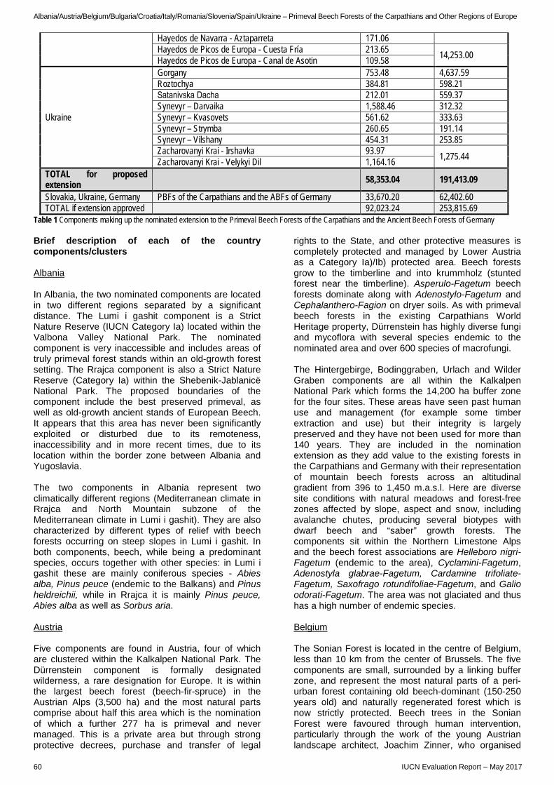
Albania/Austria/Belgium/Bulgaria/Croatia/Italy/Romania/Slovenia/Spain/Ukraine – Primeval Beech Forests of the Carpathians and Other Regions of Europe
Hayedos de Navarra - Aztaparreta 171.06 Hayedos de Picos de Europa - Cuesta Fría 213.65 14,253.00 Hayedos de Picos de Europa - Canal de Asotin 109.58
Ukraine
Gorgany 753.48 4,637.59 Roztochya 384.81 598.21 Satanіvska Dacha 212.01 559.37 Synevyr – Darvaika 1,588.46 312.32 Synevyr – Kvasovets 561.62 333.63 Synevyr – Strymba 260.65 191.14 Synevyr – Vilshany 454.31 253.85 Zacharovanyi Krai - Irshavka 93.97 1,275.44 Zacharovanyi Krai - Velykyi Dil 1,164.16
TOTAL for proposed extension 58,353.04 191,413.09
Slovakia, Ukraine, Germany PBFs of the Carpathians and the ABFs of Germany 33,670.20 62,402.60 TOTAL if extension approved 92,023.24 253,815.69
Table 1 Components making up the nominated extension to the Primeval Beech Forests of the Carpathians and the Ancient Beech Forests of Germany Brief description of each of the country components/clusters Albania In Albania, the two nominated components are located in two different regions separated by a significant distance. The Lumi i gashit component is a Strict Nature Reserve (IUCN Category Ia) located within the Valbona Valley National Park. The nominated component is very inaccessible and includes areas of truly primeval forest stands within an old-growth forest setting. The Rrajca component is also a Strict Nature Reserve (Category Ia) within the Shebenik-Jablanicë National Park. The proposed boundaries of the component include the best preserved primeval, as well as old-growth ancient stands of European Beech. It appears that this area has never been significantly exploited or disturbed due to its remoteness, inaccessibility and in more recent times, due to its location within the border zone between Albania and Yugoslavia. The two components in Albania represent two climatically different regions (Mediterranean climate in Rrajca and North Mountain subzone of the Mediterranean climate in Lumi i gashit). They are also characterized by different types of relief with beech forests occurring on steep slopes in Lumi i gashit. In both components, beech, while being a predominant species, occurs together with other species: in Lumi i gashit these are mainly coniferous species - Abies alba, Pinus peuce (endemic to the Balkans) and Pinus heldreichii, while in Rrajca it is mainly Pinus peuce, Abies alba as well as Sorbus aria. Austria Five components are found in Austria, four of which are clustered within the Kalkalpen National Park. The Dürrenstein component is formally designated wilderness, a rare designation for Europe. It is within the largest beech forest (beech-fir-spruce) in the Austrian Alps (3,500 ha) and the most natural parts comprise about half this area which is the nomination of which a further 277 ha is primeval and never managed. This is a private area but through strong protective decrees, purchase and transfer of legal
rights to the State, and other protective measures is completely protected and managed by Lower Austria as a Category Ia)/Ib) protected area. Beech forests grow to the timberline and into krummholz (stunted forest near the timberline). Asperulo-Fagetum beech forests dominate along with Adenostylo-Fagetum and Cephalanthero-Fagion on dryer soils. As with primeval beech forests in the existing Carpathians World Heritage property, Dürrenstein has highly diverse fungi and mycoflora with several species endemic to the nominated area and over 600 species of macrofungi. The Hintergebirge, Bodinggraben, Urlach and Wilder Graben components are all within the Kalkalpen National Park which forms the 14,200 ha buffer zone for the four sites. These areas have seen past human use and management (for example some timber extraction and use) but their integrity is largely preserved and they have not been used for more than 140 years. They are included in the nomination extension as they add value to the existing forests in the Carpathians and Germany with their representation of mountain beech forests across an altitudinal gradient from 396 to 1,450 m.a.s.l. Here are diverse site conditions with natural meadows and forest-free zones affected by slope, aspect and snow, including avalanche chutes, producing several biotypes with dwarf beech and “saber” growth forests. The components sit within the Northern Limestone Alps and the beech forest associations are Helleboro nigri-Fagetum (endemic to the area), Cyclamini-Fagetum, Adenostyla glabrae-Fagetum, Cardamine trifoliate-Fagetum, Saxofrago rotundifoliae-Fagetum, and Galio odorati-Fagetum. The area was not glaciated and thus has a high number of endemic species. Belgium The Sonian Forest is located in the centre of Belgium, less than 10 km from the center of Brussels. The five components are small, surrounded by a linking buffer zone, and represent the most natural parts of a peri-urban forest containing old beech-dominant (150-250 years old) and naturally regenerated forest which is now strictly protected. Beech trees in the Sonian Forest were favoured through human intervention, particularly through the work of the young Austrian landscape architect, Joachim Zinner, who organised
60 IUCN Evaluation Report – May 2017
Albania/Austria/Belgium/Bulgaria/Croatia/Italy/Romania/Slovenia/Spain/Ukraine – Primeval Beech Forests of the Carpathians and Other Regions of Europe
beech plantings during the time of the Austrian Hapsburgs (1714-1795). At that time, beech was planted on a massive scale and selectively thinned to encourage tall monumental trees referred to as “cathedral trees”. Whilst the forests within the nominated components are now the most undisturbed parts of the Sonian system, it is highly likely that some of the cathedral trees in these were planted in the past. The Sonian Forest is the northern most extent of this serial transnational extension and the nomination proposes it to represent Atlantic Beech Forest; however this is a large BFR with natural forested areas in other countries. The Sonian Forest is important as a cultural landscape for its archaeological remains, history of ownership and activities, and for its monumental trees but it is not, in IUCN’s view, a result of natural ecological processes. The Sonian Forest is currently of recreational and scientific importance and small scale commercial forestry activities are ongoing. Bulgaria In Bulgaria, all nine components are Strict Nature Reserves (Cat Ia) located within the Central Balkan National Park (Cat II) and representing its core zones (the total area of the proposed components covers approximately 15% of the territory of the national park). These areas can be considered as ancient beech forests with average age of beech communities being 135 years according to the nomination dossier. However, due to the location of the Central Balkan National Park in close proximity to human settlements and in the vicinity of major historical transport routes, it has always been a major crossroads of the Balkans and most of its territory has most likely been subject to some human disturbance and use at some point in time. Particularly, the coniferous species in the broader region have been exploited starting from ancient times and throughout modern history. However, the strict nature reserves within the national park are the most pristine areas and include some primeval areas that have never been touched. Since all nominated components in Bulgaria are located within the same National Park, they are similar; however, they also show some differences and complementarities in terms of tree species composition, including pure beech stands with very high stock density in the Boatin component. Croatia The Hajdučki i Rožanski Kukovi component is a strict nature reserve located within Northern Velebit National Park. The area extends beyond timberline to encompass Illyric subalpine beech, subalpine spruce and dwarf pine forests. These Ranunculo platanifolli-Fagetum and Polysticholonchitis-Fagetum forests are influenced by the meeting and mixing of Continental and Mediterranean climates across the long, north-south Velebit Mountain (Dinaric Alps) shared by all three Croatian nominated component parts. In this component, one of the coldest and most humid in Croatia, snow dominates along with the bora katabatic (or downslope) wind which can be, in turn, dry and extremely strong, often to hurricane force. These conditions cause interesting tree shapes, bent “saber”
trees and typical krummholz effects at treeline. The nomination includes forests from 1,200 to 1,500 m.a.s.l. and represents the component with the highest and wettest beech forests in the Illyric region and contributes to the expansion from refugia. The whole area is an endemism hot spot for Croatia, plants characteristic of coastal, inland, and alpine habitats prevail and flora (Illyrian and Dinar vegetation types) is preserved in almost pristine form. There are many endemic species native only to the area including cave/subterranean species. Located within the Paklenica National Park the two components of Suva draga-Klimenta and Oglavinovac-Javornik share the same limestone/dolomite Velebit Mountain with the strict reserve (above). The two nominated parts lie within a national park that is influenced by the meeting and mixing of Continental, Alpine and Mediterranean climates across the southern Velebit Mountain (Dinaric Alps). There are four beech communities here including thermophilous beech forests with autumn moor grass, subalpine beech, and southeastern Alpine Beech. The nomination dossier only provides information on the National Park but it can be concluded that the beech forests in both components are old growth and little used. Trees are up to 250 years old and forest communities across both nominated parts range from inland plateau (Suva) to high Alpine (Oglavinovaca) and comprise the oldest and largest beech forest complex on the Adriatic Coast. This is the only component in the Illyric Beech Region that represents the transition of beech forests to the Mediterranean oak forests. Italy The Italian components represent important aspects of postglacial recolonization: the Mediterranean refuge and its later expansion. Currently, no significant human activities occur within these components except for grazing and tourism. Five of the ten components are clustered within Abruzzo, Lazio and Molise National Park, two of the national park components have a linking buffer zone with the remaining three having separate surrounding buffer zones. Three properties in Italy are less than 100 ha and nearly all properties have had minor influence from historical logging or forest management. These components have high structural complexity and contain the oldest beech trees in Europe (560 y.o.) and trees of more than 400 years of age are widespread. All component parts are beech-dominated forests of the montane and upper-montane belt, growing on limestone/dolomite at elevations between 1,400 m and the tree line (1,850–1,950 m.a.s.l.). They belong to the associations Anemono apenninae-Fagetum and Cardamino kitaibelii-Fagetum. The components are small but in a natural state and located at high elevation, at the highest limit of the vegetation and most of them cannot expand very much due to the ecological context. Cozzo Ferriero is a strict reserve (Cat Ia) that covers only 0.05% of the much larger Pollino National Park. The component part is mostly covered by an early old-growth forest, unexploited in the last 80 years due to
IUCN Evaluation Report – May 2017 61

Albania/Austria/Belgium/Bulgaria/Croatia/Italy/Romania/Slovenia/Spain/Ukraine – Primeval Beech Forests of the Carpathians and Other Regions of Europe
its remoteness. It has an uneven-age structure, with beech trees up to 400 years old. This component is the southern most of the proposed serial extension. The Foresta Umbra component includes most of the area of two adjacent forest reserves (Foresta Umbra and Falascone), within the Gargano National Park. This component contains very tall beech trees (45 m) and other tree species such as Acer campestre and Taxus baccata which reach exceptional, uncommon size. The tallest beech trees (above 53 meters) are found in the Monte Cimino component. The beech forest survived at the top of a volcanic mountain, where it grows on fertile deep soils. Its biogeographic importance is also due to its position, at the transition between the low-elevation and the mountain belts. The vegetation is classified into the association Allio pendulini-Fagetum sylvaticae and has not been exploited for the last 70 years. The Monte Rachio component part is located within the Bracciano-Martignano Natural Park. It represents the warmest site with very fast growth rates and demographic turnover. The beech forest is mixed with other tree species (chestnut, hornbeam, maples, Turkey Oak). The component part Sasso Fratino Nature Reserve was created in 1959 as the first strict reserve in Italy. It sits within the Foreste Casentinesi, Monte Falterona and Campigna National Park (about 36,000 ha). Sasso Fratino includes beech trees of more than 500 y.o. and exhibits a large ecological gradient in a biogeographic transition zone between the temperate and Mediterranean climate regimes that transition between the Central European and Mediterranean floristic regions. Romania Romania includes 12 components which together cover the largest area of the proposed extension, some 23,983 ha with a combined buffer zone area of 64,477 ha. Mostly, these are individual components with a surrounding buffer zone, and in some cases the buffer zone links two or three components. Cheile Nerei-Beușnița is one of the largest remnant virgin forests of temperate Europe. It is a pure and mixed beech-oak forest with beech cover of over 80%. This forest grows on limestone-rendzinic generated soils and on limestone rocks and is the most southern and lowest elevation forests in the nomination from the Carpathian Beech Forest Region. The Codrul Secular Șinca component has a mixed beech-silver fir forest with a high number of trees of ages 350 to 400 years. The specific soil and climate conditions lead to the highest growth rates known from the Carpathian Beech Forest Region and the site contains the tallest beech in Europe at 55.1 m. Codrul Secular Slătioara is a mixed beech-silver fir-spruce forest dominated by beech (60%) and includes protected alpine meadow. The component cluster of Cozia consists of two component parts: Masivul Cozia and Lotrișor, separated by the Olt River defile (a gorge that has been cut into the Transylvanian Alps). The Cozia - Masivul Cozia and Lotrisor components have a linking buffer zone and protect pure and mixed forest dominated by beech. This area differs from others by virtue of its gneissic bedrock, high variation of topography, large altitudinal gradient, rocky slopes,
and warmer climate. The Domogled-Valea Cernei cluster is a large complex of beech forests consisting of three components: Ciucevele Cernei, Iauna Craiovei and Domogled-Coronini-Bedina, that are connected by a continuous forest cover and enveloped in a common much larger buffer zone. The components protect pure and mixed forest (72% of the cluster is mixed forest, 64% of cluster is beech dominated). The cluster has the largest elevational range of the nominated component extensions from the Carpathian Beech Forest Region and has diverse habitats. Groșii Țibleșului - Izvorul Șurii and Groșii Țibleșului - Preluci are also configured with a linking buffer zone. The components cover pure and mixed beech-spruce fir forest. 70% of the forests contains beech trees older than 140 years. Izvoarele Nerei is a pure beech forest which also provides large, contiguous and functional beech forest corridors for the fauna. Lastly, Strîmbu Băiuț is a pure and mixed beech-silver fir forest which provides important wildlife habitat. Slovenia The Krokar component in Slovenia is a small, but important relict protected as the Virgin Forest Krokar with a long history of science and research. Genetic research from this area shows markers for beech forests in central Europe and as far away as Britain. There is no evidence of glaciation in this forest and no evidence of cutting or logging. The forest itself is typical old growth and is an important example of the montane association in the Illyric region. Snežnik is a large karstic mountain and a mixing zone between the Continental and Mediterranean climates influenced by the katabatic bora wind. It is a region of typical and near-natural subalpine beech which gives way to dwarf pine as one nears treeline. Evidence of heavy snow loads have caused “saber” trees, bent near the ground on steep slopes. While the mountain peak itself was covered by ice, relict species were maintained with beech forests re-established 8,000 years ago. Human use included burning for pastures which ended in the 19th century but some cutting occurred in some parts of the nominated component as recently as 1980. There are old-growth, likely primeval forests identified in steep, inaccessible parts of the nomination with logging pressure nearby. Spain The beech forest components in Spain complete a gap in the Pyrenaic-Iberian BFR and represent the western most extent of the serial extension. In Spain, small nominated areas have been embedded in much larger buffer zones. Two of the Hayedos de Ayllón components (Tejera Negra and Montejo) have a 13,880 ha buffer zone; the Hayedos de Navarra components (Lizardoia and Aztaparreta) share a buffer zone of nearly 24,500 ha; and the Cuesta Fría and Canal de Asotin components in Hayedos de Picos de Europa share a similarly larger buffer zone of 14,253 ha. Both humid (Picos de Europa and Navarra) and summer drought (Ayllon) conditions are found in the Spanish components.
62 IUCN Evaluation Report – May 2017
Albania/Austria/Belgium/Bulgaria/Croatia/Italy/Romania/Slovenia/Spain/Ukraine – Primeval Beech Forests of the Carpathians and Other Regions of Europe
The Hayedos de Ayllón components are in the Mediterranean biogeographical region in central Spain with acidophilous beech forests (Galio rotundifolii-Fagetum sylvaticae). The component part of Tejera Negra sits within a Natural Park in the Autonomous Community of Castilla-La Mancha. The component part of Montejo de la Sierra covers a small area in the core zone of a Biosphere Reserve in the Autonomous Community of Madrid. The forest types are high altitude beech forest in Tejera Negra and mixed oak (Quercus pyrenaica and Q. petraea) – beech forest in Montejo de la Sierra. The buffer zones are important for grazing and recreation. The component group of Hayedos de Navarra includes Aztaparreta and Lizardoia in the western Pyrenees range with Asperulo-Fagetum beech forest and some Atlantic acidophilous beech forests. The components coincide with the borders of two Strict Reserves (Cat Ia). The buffer zone overlaps with the borders of three Natura 2000 Special Areas of Conservation. There is a large range of flora and fauna species present including sporadic presence of brown bear and the western limit of several European species. The buffer zone is important for recreation and tourism, forestry and grazing. Forestry and grazing activities can potentially interfere with the natural succession and expansion of old growth forest into the buffer zone. Hayedos de Picos de Europa consists of Canal de Asotin and Cuesta Fría. The forests mainly protect Medio-European limestone beech forests of Cephalanthero- Fagion. Atlantic acidophilous beech forest is also present in Cuesta Fria. The phytosociological association in Canal de Asotin is Epipactido helleborines-Fagetum, while in Cuesta Fría two different associations are found: Blechno spicanti-Fagetum and Carici sylvaticae-Fagetum. The buffer zone here is important for recreation and tourism including Nordic skiing in winter. Ukraine Nine components occur within Ukraine, three separate sites and two clusters. There is a mix of different boundary configurations in place. The Gorgany component covers primeval and old-growth mixed coniferous-beech forests with trees having a mean age of between 250 to 280 years. The forest consists of beech, spruce, fir and Swiss-pine which is a relict species. The area is mountainous with a mosaic of habitats, rich in lichens, mosses and fungi. The Roztochya component is a hilly ridge (203-403 m.a.s.l) representing the northeastern limit of beech distribution, and is characterized by rare groups of pine-beech forests [Pineto (sylvestris)-Fageta (sylvaticae)]. The forests coincide with a nature reserve and are in good condition having been protected from the 19th Century onwards. Individual trees are more than 200 years old. The Satanіvska Dacha component also lies at relatively low elevations (from 300 to 395 m.a.s.l.). The main type of forest is hornbeam beech forest with Carici pilosae-Fagetum and Galio odorati-Fagetum associations. This component lies at the eastern limit of the beech forest’s range, beyond which Fagus sylvatica occurs only as single trees. The forest of Roztochya and
Satanivska Dacha components are characterised by unique adaptation to the extreme climatic conditions in this region, namely the much lower humidity and rather dry summers. Four components are clustered in the Synevyr National Park which includes some of the largest beech forests that have survived in the Eastern Carpathians. The nomination notes that the local beech forests have never been exposed to any form of forest management. Each component has its own surrounding buffer zone with what appears to be a narrow buffer zone corridor area connecting the Darvaika and Strymba areas and a similar boundary configuration between the Kvasovets and Vilshany areas. The main types of forest here are pure beech and mixed beech-fir-spruce forests. Over 70% of the beech forests are occupied by the Fagetum dentariosum and F. asperulosum association. The Kvasovets and Vilshany components are directly adjacent to the existing World Heritage component of Uholka-Shyrokyi Luh in Ukraine. Finally, two components, Zacharovanyi Krai – Irshavka and Velykyi Dil are clustered with a linking buffer zone. The nomination dossier notes that these components are distinguished from the primeval forests of Slovakia and the Carpathian Biosphere Reserve (within the existing World Heritage property) by being distributed on volcanic bedrocks, which are represented by typical (Fagetum sylvaticae) and unique communities of beech (Fagetum sylvaticae humile, Fagetum sylvaticae myrtillosum, Sorbeto-Fagetum humile), which exist in the specific cool climate. 3. COMPARISONS WITH OTHER AREAS Although IUCN, FAO, CBD and others use the term primary forest, there are a number of other terms used worldwide to describe the naturalness of forest systems: old growth, primary, virgin, frontier, intact etc. The terms primeval and ancient are in common use in Europe. Current thinking defines forests in terms of degrees of intactness (structural integrity, ecosystem function, species and genetic richness, habitat diversity etc.). Primary forest may be defined as largely undisturbed forests exhibiting the full range of ecological and evolutionary processes (including successional stages). These forests have largely continuous canopy cover and display a full complement of evolved characteristic plants and animals. The nomination dossier includes a comparative analysis which appropriately compares the proposed extension components and clusters against relevant European Beech Forests. The nominated property is compared to six World Heritage properties and a further eight tentative listed properties in the deciduous forest regions of Europe. The analysis concludes that, besides the Primeval Beech Forests of the Carpathians and Ancient Beech Forests of Germany, only a few other existing World Heritage sites include beech forest. It also stresses that only the proposed extension has a focus on European Beech and possesses the spatial scope to protect these continental wide values.
IUCN Evaluation Report – May 2017 63
Albania/Austria/Belgium/Bulgaria/Croatia/Italy/Romania/Slovenia/Spain/Ukraine – Primeval Beech Forests of the Carpathians and Other Regions of Europe
The Outstanding Universal Value of Primeval Beech Forests of the Carpathians and the Ancient Beech Forests of Germany has been previously accepted by the World Heritage Committee. In terms of criterion (ix) the Committee stated “The Primeval Beech Forests of the Carpathians and the Ancient Beech Forests of Germany are indispensable to understanding the history and evolution of the genus Fagus, which, given its wide distribution in the Northern Hemisphere and its ecological importance, is globally significant. These undisturbed, complex temperate forests exhibit the most complete and comprehensive ecological patterns and processes of pure stands of European beech across a variety of environmental conditions and represent all altitudinal zones from seashore up to the forest line in the mountains. Beech is one of the most important elements of forests in the Temperate Broad-leaf Forest Biome and represents an outstanding example of the re-colonisation and development of terrestrial ecosystems and communities after the last ice age, a process which is still ongoing. They represent key aspects of processes essential for the long-term conservation of natural beech forests and illustrate how one single tree species came to absolute dominance across a variety of environmental parameters” (Decision 35 COM 8B.13). Beyond the overall questions of Outstanding Universal Value, the other crucial issue with a serial site is the comparative analysis supporting the selection of appropriate component parts. The nominated extension to the existing property must demonstrate that it adds significant attributes to the agreed Outstanding Universal Value (in terms of values, integrity and protection and management), as articulated in the Committee Decision above, and/or improves integrity, protection and management. In this respect, IUCN recalls that, with the 2011 approval of the German extension, the Outstanding Universal Value of the Slovenian and Ukrainian Carpathians site was conceptually broadened to also include ancient beech forests, those forests with evidence of past human use but exhibiting a long period without disturbance. The States Parties have clarified in supplementary information that the main goal of the nominated extension is to “preserve the last remnants of ancient and primeval European Beech forests as examples of complete and comprehensive ecological patterns and processes of pure and mixed stands across a variety of environmental conditions in the still ongoing postglacial continental wide expansion process”. In the IUCN Panel’s view, this is consistent with the way in which the World Heritage Committee’s understanding of values has evolved as the site has increased in size and complexity. Using the framework of the revised European Beech Forest Regions, the existing World Heritage property in Slovakia, Ukraine and Germany protects primeval and ancient beech forests covering three of the 12 BFRs (Carpathian, Baltic and Subatlantic-Hercynic). The nominated extension adds components and clusters to expand this representation to 10 of the 12 BFRs (there are no representative components from the Pannonic and Euxnic BFRs). The nomination argues that the components added to
the existing World Heritage site now “contain all elements pertaining to the complete illustration of the Outstanding Universal Value of the ongoing ecological processes following the last glacial period. From rejuvenation to degradation, from the gap in the forest canopy to the closed beech canopy, from the beech sapling to the majestic giant tree, the entire development cycle of natural beech forests is present in each of the component parts”. Despite this statement, IUCN is nevertheless not convinced that the site, as configured, ensures the ongoing ecological patterns and processes which are essential to support living and complex forests. There also seems to be an assumption in the nomination that having beech forest representation from each BFR will automatically contribute to the overall story of Outstanding Universal Value as defined. It is not clear what each BFR brings to this story of Outstanding Universal Value and a serial configuration which most effectively tells the story may have a skewed representation of BFRs. A further fundamental point, also discussed under point 5 below, is that the current nomination clearly does not represent a finite series, nor indicate what an eventual finite series would be, despite the previous request of the World Heritage Committee. There are BFR that are not represented, and countries with significant beech forest not included in the nomination (most clearly Poland, who withdrew initially nominated component parts from the series). In summary, IUCN considers that the current nomination does include many areas of good quality European Beech forest with the potential to strengthen the Outstanding Universal Value of the existing Primeval Beech Forests of the Carpathians and the Ancient Beech Forests of Germany World Heritage property, notably the larger component parts and those with the most primeval and ancient characteristics. Nevertheless, whilst the site review and selection process undertaken by the States Parties have worked to define a set of component parts and clusters which cover most of the European BFRs, there remain major questions related to the choice and configuration of the nominated components, integrity and some aspects of protection and management. These questions related to the justification of component parts within the nominated extension are further discussed in detail below. 4. INTEGRITY, PROTECTION AND MANAGEMENT 4.1. Protection The nomination notes that a legally defined strict protection regime was a pre-requisite for site selection. Furthermore, that all nominated component parts are subject to strict protection on a permanent legal basis preventing negative human influences such as timber extraction, construction of infrastructure etc. Almost all the nominated components are publicly owned although there are some components or parts of complements which are privately owned, managed under contractual arrangements or managed through communities.
64 IUCN Evaluation Report – May 2017
Albania/Austria/Belgium/Bulgaria/Croatia/Italy/Romania/Slovenia/Spain/Ukraine – Primeval Beech Forests of the Carpathians and Other Regions of Europe
The components are protected by various pieces of national and regional legislation within the different countries. A schedule of protective instruments applying to each component and/or cluster is provided in the nomination dossier. The site selection process also chose components which have enjoyed long term protection and many areas are managed according to IUCN Category Ia). At national and local levels, there are management authorities in place, working within the legislative and policy frameworks to ensure the protection of these components, a point reinforced by the States Parties in their supplementary information. Most of the nominated components are embedded within larger protected areas and so are managed within that context, although details are lacking. Management systems vary between nominating States Parties with some having more top-down systems and others more participatory governance approaches. The nomination dossier documents the history of protection and past human interventions in the nominated components. Some of the components, such as in Belgium, have some areas which were protected in the 1850s and other areas subject to much more recent protection decrees (2010 and 2016). Many have experienced past human interventions and a number have been free of active forestry practices for only a few decades. Whilst some of the areas have a similar legacy of past uses as the German additions approved in 2011, the series include areas (most notably in Belgium) where the scope of past use is of a different character with significant loss of naturalness. All five IUCN field missions concluded that adequate protection regimes were in place within the nominated components; however, many concerns were expressed regarding how surrounding protected areas, zoning systems and the proposed World Heritage buffer zones will specifically protect Outstanding Universal Value in a consistent way across all components. This represents a critical issue, and in the view of IUCN, amounts to an inadequate overall protection of the nominated property from external threats, especially in view of the small size off many of them. This is further discussed below. IUCN considers the protection status of the nominated property does not meet the requirements of the Operational Guidelines. 4.2 Boundaries Site selection and design including the effectiveness of the buffer zone configurations are central considerations in the evaluation of this nomination. IUCN notes that the nomination includes many components that are small (and some very small), including many components (over one third) under 300 ha. There is a clear and concerning trend toward smaller components compared to the existing property to which this nomination would serve as an extension, with the average size in the present nomination being 871 ha compared to an average of 2,200 ha in the inscribed site, a reduction of around 60%. Whilst there
are a number of large and impressive component parts included in the nomination, the small size of many components raises clear and serious concerns as to whether they can truly reflect “on-going post-glacial biological and ecological evolution of terrestrial ecosystems”. Similarly, buffer zones in the existing property average 4,160 ha, whereas they average 2,857 ha in the current nomination. In supplementary information, the States Parties have provided additional material and state that, for these forests, a 50 ha minimum size is adequate to support ongoing forest development and natural ecosystem dynamics. The States Parties indicated the inclusion of some smaller components (<300ha) is justified as these represented “the rear edge of the ecological amplitude of beech and that these ‘frontier posts’ are naturally limited to small island-like patches”. However, analyzing the component size based on 300 ha is somewhat misleading as 11 of the components are <100ha and four of the Belgium components are <50 ha which was argued by the States Parties as the minimum viable forest size, so these components are clearly inappropriate even on the minimalist argument advanced. IUCN wishes to recall that the purpose of the World Heritage Convention is to recognize Outstanding Universal Value, and an approach to selecting sites based on minimum requirements is clearly not appropriate. Furthermore, a large number of small components creates clear risks of extensive State of Conservation issues, which the Committee will note is already a factor in the existing inscribed site. IUCN considers in this regard that the site configuration is fundamentally flawed and needs to be reconsidered to be more selective, and to maintain at least the current standards of the series in terms of the average size of component parts included, with a minimal number of small sites, included only if they are truly exceptional. In its progress report, the IUCN Panel expressed concerns about some of the site selections including the rationale for multiple components in some BFRs and if this entailed redundancy or duplication. The States Parties provided additional information on the process of filtering potential sites down to the ones proposed and clarified that, where possible, some deliberate redundancy was considered beneficial to counter threats and the risk of small fragments being impacted to the point where they lose their values. Nevertheless, it appears there is great variety in the approach to site selection in this regard between different BFRs and countries. IUCN respects there has been a lengthy and complex site selection process undertaken by the States Parties and, whilst concluding that this selection is problematic, believes it is neither appropriate via the present evaluation to “pick and choose” between components that are (and are not) consistent with the existing inscribed site nor try and redesign buffer zones. Nevertheless, it is clear that maintaining ecological patterns and processes for European Beech across a variety of environmental conditions requires a configuration where components are ecologically viable, well-buffered and connected. As one example, to most clearly illustrate these problems, the Sonian
IUCN Evaluation Report – May 2017 65
Albania/Austria/Belgium/Bulgaria/Croatia/Italy/Romania/Slovenia/Spain/Ukraine – Primeval Beech Forests of the Carpathians and Other Regions of Europe
Forest components in Belgium clearly are inappropriate for inclusion in the series. In this case, integrity requirements are not met as all five components in this cluster are small, and four components are exceptionally small (24, 37, 14 and 6.5 ha) and well below even the minimum 50 ha size for viability of an old-growth beech forest stated by the States Parties in supplementary information. Fundamentally, as noted above, it is apparent that beech trees in the nominated components of this forest were planted (albeit centuries years ago) and beech has also been actively favored in management over oak and other native tree species. IUCN considers these forests are not the result of natural ecological processes and evolution. The general concerns about small component size is mitigated, but not fully addressed, by the fact that most of the nominated components are strict nature reserves embedded in larger protected areas and that some protected areas contain several components within them, grouped together as a cluster. However, in many instances the protected areas in which the components are found allow activities such as grazing/transhumance, forestry, gathering of plants and mushrooms, recreational activities etc., in some cases at intense levels, which threaten the integrity of the nominated components. Reviewers have noted that some buffer zones may permit logging to open up canopies by up to 60%. In addition, specific management measures (restrictions on uses in the buffer zone or increases in staffing to monitor the site) do not seem to be foreseen to ensure the continued integrity of the components. The rationale for this is that many of the nominated components are designated as strict nature reserves with non-intervention as a management principle and are already embedded in protected areas, and therefore do not require specific protective measures. However, the current degree of use in many buffer zones, and the possibility that World Heritage status would increase visitor pressures, suggest that a business as usual approach to management in buffer zones is not sufficient to guarantee maintenance of Outstanding Universal Value. IUCN stressed the importance of effective buffering in its 2011 evaluation of the German extension wherein good buffer zone design and effectiveness were seen as the only feasible way to protect the integrity of these small forest remnants, a situation amplified in this nomination as buffer zones are smaller. Whilst not formally part of the nominated extension, the buffer zones of the nominated components and clusters are covered within the proposed Integrated Management System (IMS) in recognition of their importance. In addition, the approach to designing the buffer zones in different components/clusters differs greatly from country to country and is inconsistent across the nominated series. For example, within the nomination dossier, the map of Snežnik-Ždrocle (Slovenia) shows the nominated area surrounding by a very narrow uniform-width buffer zone of perhaps 50-60m. The nominated area is more than 5.5 times the area of the buffer zone. Contrasting this is the immediately following map of Hayedos de Ayllón - Tejera Negra
and Montejo components (Spain) where an entirely different approach has been taken. Here there is a linking buffer zone of 13,880.86 ha enveloping both small components, and the buffer zone is 42 times larger than the nominated area. The site design in all the Spanish components appears to have adopted an approach to envelop the smaller components within larger buffer zones. Other State Parties have adopted a mixed approach – some components with small surrounding buffer zones, others embedded in larger buffering systems. It is also not clear how World Heritage buffer zones add to the protection already afforded by protected area zoning systems or how the management of the buffer zones will favor the maintain of the Outstanding Universal Value attributes and the integrity of each cluster in the long term. On the contrary, based on the information provided, it seems that the present management and use of buffer zones exerts high pressure on many nominated clusters. To sum up, the proposed extension comprises remnant areas of a beech forest that was formerly more widespread across Europe. An appropriate protection context is therefore critical to ensure the stated Outstanding Universal Value is retained and that ongoing dynamic forest development continues. IUCN considers that an extensive review of the site components as well as the buffer zone boundaries of the site is necessary to ensure a consistent and cohesive approach across all components and clusters. Similarly, a review should be undertaken to guarantee that consistent and sympathetic buffer zone management regimes are in place. This is consistent with proposals within the planned expanded IMS to build greater connectivity across the beech forest network. Taken as a whole, these measures would assure that component parts are ecologically viable and that surrounding forest management practices support the protection of Outstanding Universal Value and mitigate any negative impacts from external threats. IUCN would be willing to work with the States Parties to undertake this review. IUCN considers that the boundaries of the nominated property and buffer zones clearly do not meet the requirements of the Operational Guidelines. 4.3 Management The nomination dossier contends that the component parts represent primeval or ancient beech forests which, by definition, should only require limited active management, the main task being to enforce a strict non-intervention strategy. Logging, thinning and the use of heavy machinery is prohibited inside the component parts as is grazing and any infrastructure construction. Public access is permitted. The nomination states that the intention of management is to “safeguard the ongoing evolutionary and natural dynamic processes to preserve the entire biological diversity of the beech forests” which is undoubtedly the aim of management inside the strictly protected zones of the components. However, all nominated components lie within larger protected systems and the States Parties in supplementary information have advised that “usually, the borders of the buffer zone
66 IUCN Evaluation Report – May 2017
Albania/Austria/Belgium/Bulgaria/Croatia/Italy/Romania/Slovenia/Spain/Ukraine – Primeval Beech Forests of the Carpathians and Other Regions of Europe
are already aligned with existing protected area zoning systems”. The nomination provides some general information on how the buffer zones will be managed but despite these assurances, IUCN remains unclear about the degree to which overall protected area and zone management objectives purposely support the above stated intention specific to the protection of Outstanding Universal Value. As noted above, some buffer zones are very small and there are several management practices in the surrounding protected areas which could impact values within the components. All the nominated components and clusters are covered by national level plans which stress protection and non-interventionist management policies, a reflection of the strict protection regimes of a Category Ia) protected area. There is no overarching management plan or framework yet in place for the transnational serial property but plans are noted to expand the Integrated Management Strategy of the existing trinational site to include other countries should the extension be approved (discussed further below). Resourcing levels (staffing capacity and budgets) are variable across the ten States Parties. The nomination reports that staffing levels vary between 4 and approximately 150 active employees in the nominated component parts and surroundings. Contrasts exist for example in Bulgaria where the Central Balkan National Park appears to be relatively well resourced (ca. 70 staff); however, in Romania the components were considered to be suffering from inadequate budgets and staffing. The nomination did not provide detailed country by country budget proposals should the extension be approved, again as the management of the components is more often absorbed into larger protected area operations. In general, and given the level of threats, the staffing and budgets are considered adequate for the management of the nominated components noting that many sit within larger protected areas. Beyond national level resourcing is the question of how coordination across the multinational serial site will be funded. This is not specified except for a commitment to action funding once the extension is approved. IUCN would like to see a more quantified commitment to the funding that will be necessary to enable an effective transnational serial site of this unprecedented scope. At this stage, IUCN is concerned that an appropriate level of precision in this matter is not in place, and notes that the arrangements for the current nominated property have not prevented serious issues being adequately addressed regarding State of Conservation. There appears a significant risk for the Convention, given the doubts regarding the effectiveness of protection of the individual component parts, of an unmanageable conservation caseload, unless the adequacy and durability of sustainably funded international cooperation is guaranteed. Please see also section 5.1c. Given concerns regarding the lack of an overarching management framework and a long-term sustainable financial mechanism for the transnational serial site,
IUCN considers the management of the nominated property does not meet the requirements of the Operational Guidelines. 4.4 Community In general, these forest components are embedded in larger protected areas which are uninhabited. The IUCN missions did not detect any particularly contentious issues with communities. There are variable levels of awareness of the nomination process and the degree of community participation in management is also varied across the different States Parties depending on their governance approaches. The nomination dossier emphasizes the importance of stakeholder involvement to foster favorable local perceptions and identifies relevant stakeholders from NGOs, forest management representatives or forest administrations, hunting and tourist associations, as well as representatives of local landowners and communal administrations. There are also Integrated Management Panels (IMPs) which operate as local platforms of communication between the component part management and stakeholders. The IMPs will be integrated into existing participatory structures where they exist and/or established at each component/cluster level. Some IUCN field missions noted poor community engagement practices for example where stakeholders were not invited to meet with the evaluator. 4.5 Threats Threats regarding the small size of many components and the status of, and activities within, buffer zones are noted above and not repeated here in detail. The forests nominated are remnants of once more extensive beech forest across Europe and are generally strictly protected areas embedded within larger less strictly protected areas. Several of the components are difficult to access even though they exist in visited national parks. The nomination notes that development pressures are not significant with most components being remote from developed areas, the exception being the Sonian Forest in Belgium which is adjacent to the city of Brussels. In the case of the Belgium components there is risk of atmospheric pollution on tree growth, fragmentation impacts and intense use given the proximity to urban areas. Environmental pressures elsewhere are mostly therefore more indirect and threats arise, not so much in the components themselves but in the surrounding protected areas through practices such as grazing/transhumance, silviculture, gathering of plants and mushrooms, recreational activities and so forth. An example is grazing within the Central Balkans National Park which is managed by annual quotas to local herders and where there is pressure to see additional areas opened to stock. Here grazing may impact seedlings and young trees limiting the natural ecological development of forests beyond the nominated areas. As discussed above, the size and efficacy of the buffer zones needs to be reviewed to mitigate against these potential threats to the components themselves.
IUCN Evaluation Report – May 2017 67
Albania/Austria/Belgium/Bulgaria/Croatia/Italy/Romania/Slovenia/Spain/Ukraine – Primeval Beech Forests of the Carpathians and Other Regions of Europe
Several components permit public access through hiking trails; however, these threats appear to be limited or adequately managed in more popular areas. In the event of the extension being approved, a potential growth in visitor interest may result and this eventuality would need to be anticipated and planned for. Climate change is noted as a potential threat to these forests for example through changes in precipitation and increasing aridity. However, studies have shown that European Beech seems to have a high tolerance to climatic variables and competes well under all climatic conditions. In Albania, a hydropower project has been approved within the boundaries of the Valbona Valley National Park and some preparatory construction works appear to have started. At least ten more hydropower projects are planned on the Valbona River, some of them within the national park and there are other controversial hydro developments in other parts of the country such as the Vjosa River. Whilst these are unlikely to directly impact the nominated areas, there are hard to predict impacts on hydrology, ecology and social systems. In summary, IUCN considers that whilst the condition and protection of many individual components is good, buffer zones are not adequate and the integrity requirements of the Operational Guidelines are not met by the nominated extension. 5. ADDITIONAL COMMENTS 5.1 Consideration in relation to serial properties a) What is the justification for the serial approach? The precedent of previous evaluations and Committee decisions has established that a serial approach is necessary to relate a pan-European story of Outstanding Universal Value for the post-glacial spread and development of European Beech. The Committee’s decision which encourage the States Parties to define what constitutes “a finite serial transnational nomination” implies that this approach is not only justified but desirable to tell a complete story. The altered landscape of Europe has also created ‘islands’ of intact primeval and ancient beech forest in a ‘sea’ of settlement which means a series of separate components and clusters is necessary to demonstrate Outstanding Universal Value. This nomination again raises the question of what would constitute a finite serial site for European Beech forest as has been called for by the World Heritage Committee. IUCN notes that, despite the current, multi-component nomination for extension, there remains the potential and perhaps the necessity for additional sites to be added progressively. The site selection process canvassed a wider array of States Parties, some of whom were reportedly (by the nominating States Parties) not interested or unable to participate at the time, and the State Party of Poland withdrew its
components prior to evaluation. The States Parties have acknowledged the scope for further additions to this site whilst noting that potential is limited, as all but two of the European BFRs would be represented if the current extension were to be approved. Thus a serial approach is justified in principle, however the present nomination is not, as was requested by the Committee, either of itself a finite series, nor is it indicating what an eventual finite series could be. b) Are the separate component parts of the nominated property functionally linked in relation to the requirements of the Operational Guidelines? Many of the components nominated for extension as well as the existing components of the Primeval Beech Forests of the Carpathians and the Ancient Beech Forests of Germany World Heritage property are linked through the common post-glacial development of a single species (F. sylvatica) across Europe. Nevertheless, some components such as those in Belgium are not considered to contribute to this Outstanding Universal Value as they do not represent natural ecological processes. Furthermore, there are no direct functional linkages in terms of the assurance of conservation between the majority of the components, which are ”islands” of strictly protected forest with weak buffer zones in some cases. c) Is there an effective overall management framework for all the component parts of the nominated property? There is, at this time, no effective overall management framework in place for all the component parts of the nominated property nor is there an indicative budget to support the effective coordination which will be necessary for this proposed complex transnational serial property. There is nonetheless a strong history of cooperation between the nominating States Parties through the processes of site selection and preparing the nomination. A Joint Management Plan (JMP) was in place between Slovakia and Ukraine and was expanded to include Germany in an Integrated Management System (IMS) that outlined the mechanism for trilateral cooperation between the three countries following the extension of 2011. The current nomination proposes that upon approval the IMS will be further expanded to encompass all components across the 12 States Parties. Further that a Joint Declaration of Intent agreed between the Slovakia, Ukraine and Germany has been extended to include the new States Parties and will be signed upon approval of the extension. Some details of the proposed expanded IMS are provided in the nomination. As part of the IMS, a similarly expanded Joint Management Committee (JMC) is foreseen to oversee integrated transnational management across the property. IUCN raised concerns with the States Parties that all these coordination mechanisms remain proposals until an extended site is realized. The Parties in supplementary information have clarified that the statutory limitations for most countries mean the measures can only be introduced following inscription. A similar situation exists with transnational financing mechanisms. All 12
68 IUCN Evaluation Report – May 2017
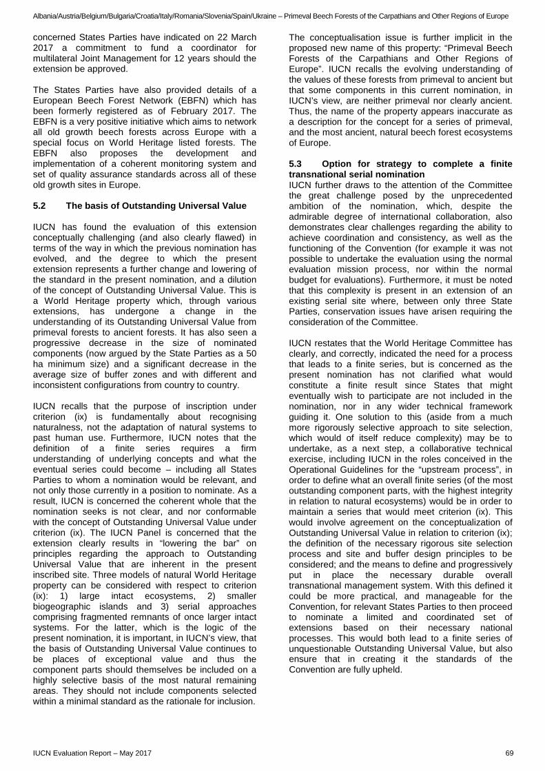
Albania/Austria/Belgium/Bulgaria/Croatia/Italy/Romania/Slovenia/Spain/Ukraine – Primeval Beech Forests of the Carpathians and Other Regions of Europe
concerned States Parties have indicated on 22 March 2017 a commitment to fund a coordinator for multilateral Joint Management for 12 years should the extension be approved. The States Parties have also provided details of a European Beech Forest Network (EBFN) which has been formerly registered as of February 2017. The EBFN is a very positive initiative which aims to network all old growth beech forests across Europe with a special focus on World Heritage listed forests. The EBFN also proposes the development and implementation of a coherent monitoring system and set of quality assurance standards across all of these old growth sites in Europe. 5.2 The basis of Outstanding Universal Value IUCN has found the evaluation of this extension conceptually challenging (and also clearly flawed) in terms of the way in which the previous nomination has evolved, and the degree to which the present extension represents a further change and lowering of the standard in the present nomination, and a dilution of the concept of Outstanding Universal Value. This is a World Heritage property which, through various extensions, has undergone a change in the understanding of its Outstanding Universal Value from primeval forests to ancient forests. It has also seen a progressive decrease in the size of nominated components (now argued by the State Parties as a 50 ha minimum size) and a significant decrease in the average size of buffer zones and with different and inconsistent configurations from country to country. IUCN recalls that the purpose of inscription under criterion (ix) is fundamentally about recognising naturalness, not the adaptation of natural systems to past human use. Furthermore, IUCN notes that the definition of a finite series requires a firm understanding of underlying concepts and what the eventual series could become – including all States Parties to whom a nomination would be relevant, and not only those currently in a position to nominate. As a result, IUCN is concerned the coherent whole that the nomination seeks is not clear, and nor conformable with the concept of Outstanding Universal Value under criterion (ix). The IUCN Panel is concerned that the extension clearly results in “lowering the bar” on principles regarding the approach to Outstanding Universal Value that are inherent in the present inscribed site. Three models of natural World Heritage property can be considered with respect to criterion (ix): 1) large intact ecosystems, 2) smaller biogeographic islands and 3) serial approaches comprising fragmented remnants of once larger intact systems. For the latter, which is the logic of the present nomination, it is important, in IUCN’s view, that the basis of Outstanding Universal Value continues to be places of exceptional value and thus the component parts should themselves be included on a highly selective basis of the most natural remaining areas. They should not include components selected within a minimal standard as the rationale for inclusion.
The conceptualisation issue is further implicit in the proposed new name of this property: “Primeval Beech Forests of the Carpathians and Other Regions of Europe”. IUCN recalls the evolving understanding of the values of these forests from primeval to ancient but that some components in this current nomination, in IUCN’s view, are neither primeval nor clearly ancient. Thus, the name of the property appears inaccurate as a description for the concept for a series of primeval, and the most ancient, natural beech forest ecosystems of Europe. 5.3 Option for strategy to complete a finite transnational serial nomination IUCN further draws to the attention of the Committee the great challenge posed by the unprecedented ambition of the nomination, which, despite the admirable degree of international collaboration, also demonstrates clear challenges regarding the ability to achieve coordination and consistency, as well as the functioning of the Convention (for example it was not possible to undertake the evaluation using the normal evaluation mission process, nor within the normal budget for evaluations). Furthermore, it must be noted that this complexity is present in an extension of an existing serial site where, between only three State Parties, conservation issues have arisen requiring the consideration of the Committee. IUCN restates that the World Heritage Committee has clearly, and correctly, indicated the need for a process that leads to a finite series, but is concerned as the present nomination has not clarified what would constitute a finite result since States that might eventually wish to participate are not included in the nomination, nor in any wider technical framework guiding it. One solution to this (aside from a much more rigorously selective approach to site selection, which would of itself reduce complexity) may be to undertake, as a next step, a collaborative technical exercise, including IUCN in the roles conceived in the Operational Guidelines for the “upstream process”, in order to define what an overall finite series (of the most outstanding component parts, with the highest integrity in relation to natural ecosystems) would be in order to maintain a series that would meet criterion (ix). This would involve agreement on the conceptualization of Outstanding Universal Value in relation to criterion (ix); the definition of the necessary rigorous site selection process and site and buffer design principles to be considered; and the means to define and progressively put in place the necessary durable overall transnational management system. With this defined it could be more practical, and manageable for the Convention, for relevant States Parties to then proceed to nominate a limited and coordinated set of extensions based on their necessary national processes. This would both lead to a finite series of unquestionable Outstanding Universal Value, but also ensure that in creating it the standards of the Convention are fully upheld.
IUCN Evaluation Report – May 2017 69
Albania/Austria/Belgium/Bulgaria/Croatia/Italy/Romania/Slovenia/Spain/Ukraine – Primeval Beech Forests of the Carpathians and Other Regions of Europe
6. APPLICATION OF CRITERIA The Primeval Beech Forests of the Carpathians and Other Regions of Europe has been nominated as an extension to the Primeval Beech Forests of the Carpathians and the Ancient Beech Forests of Germany (Slovakia, Ukraine and Germany) under natural criteria (ix). Criterion (ix): Ecosystems/communities and ecological/biological processes The nomination dossier proposes the values of an extended property to be “indispensable to understand the history and evolution of the genus Fagus, which, given its wide distribution in the Northern Hemisphere and its ecological importance, is globally significant. Beech is one of the most important elements of forests in the Temperate Broadleaf Forest Biome and represents an outstanding example of the recolonization and development of terrestrial ecosystems and communities since the last ice age”. IUCN concurs with this description of the values which any series of components should possess to potentially meet criterion (ix), but does not consider that the nomination meets either the requirement to represent this phenomenon, nor does it meet the requirements of Outstanding Universal Value as defined in the Operational Guidelines. Concerns include that the nominated extension series includes some components that are neither primeval nor ancient; reduces the standard of integrity as related to the present series by selecting sites at (and in some cases even below) a minimal standard, rather than the most exceptional sites; and does not represent (or indicate what could be) an eventual finite selection for a serial property. IUCN considers that a much more selective and better configured series, with redesigned component part and buffer zone boundaries would be required in order to meet criterion (ix), as an extension of the present inscribed series. This could involve some of the nominating and some other State Parties, and could certainly include some of the component parts in the present nomination of greatest nature conservation significance. IUCN considers that, the nominated extension does not meet this criterion. 7. RECOMMENDATIONS IUCN recommends that the World Heritage Committee adopts the following draft decision: The World Heritage Committee, 1. Having examined Documents WHC/17/41.COM/8B and WHC/17/41.COM/INF.8B2;
2. Defers the nomination of the Primeval Beech Forests of the Carpathians and Other Regions of Europe (Albania / Austria / Belgium / Bulgaria / Croatia / Italy / Romania / Slovenia / Spain / Ukraine) taking note of the potential for parts of the nominated property to meet criterion (ix), in order to allow the relevant States Parties, with the support of IUCN if requested, to:
a) Critically review component site selections and configurations to ensure ecological viability, and propose a much more selective set of series, of fewer, larger and more natural components representing the most intact primeval and ancient forests, retaining the standards and basis for Outstanding Universal Value of the presently inscribed series in Germany, Slovakia and Ukraine.
b) Critically review buffer zone design and effectiveness to ensure a consistent approach; to align boundaries with existing protected area zoning boundaries; to expand buffer zones to fully surround components where they are in close proximity; and to ensure the buffer zones prescribe how potentially impactful activities will be mitigated to safeguard the integrity of the nominated components and allow room for the continued expansion of natural forest development.
c) Define a clearly understood finite series, based on a clearly defined Statement of Outstanding Universal Value and property name that is coherent with the current inscribed property, within which any further nominated extensions would be clearly and consistently configured.
d) Assure that any further nomination provides clear and committed funding arrangements, to support consistent national site management as well as coordinated management across the complex transnational serial property and, should the extension be approved, guarantee overall, protection levels and consistent standards to avoid any recurrence of the type of conservation issues which have arisen in the existing World Heritage property.
3. Thanks the States Parties for their cooperation in developing this nomination and encourages them, and the other relevant States Parties, to continue close cooperation through the expansion of the Integrated Management System and the implementation of the European Beech Forest Network that ensure the protection of the functional linkages between the component parts, harmonized monitoring, research and standard setting and the sharing of technical expertise.
70 IUCN Evaluation Report – May 2017
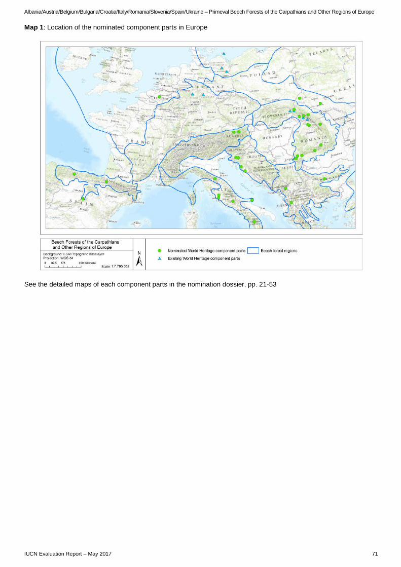
Albania/Austria/Belgium/Bulgaria/Croatia/Italy/Romania/Slovenia/Spain/Ukraine – Primeval Beech Forests of the Carpathians and Other Regions of Europe
Map 1: Location of the nominated component parts in Europe
See the detailed maps of each component parts in the nomination dossier, pp. 21-53
IUCN Evaluation Report – May 2017 71

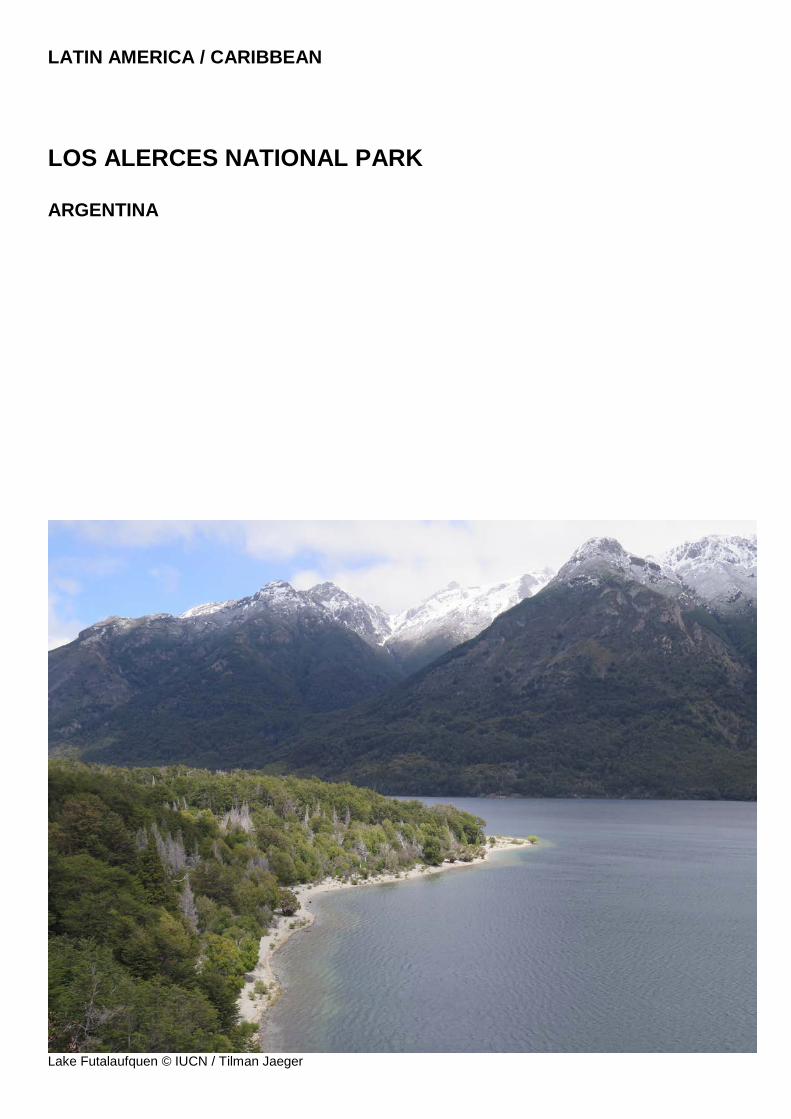
LATIN AMERICA / CARIBBEAN
LOS ALERCES NATIONAL PARK ARGENTINA
Lake Futalaufquen © IUCN / Tilman Jaeger

Argentina - Los Alerces National Park
WORLD HERITAGE NOMINATION – IUCN TECHNICAL EVALUATION
LOS ALERCES NATIONAL PARK (ARGENTINA) – ID N° 1526
IUCN RECOMMENDATION TO WORLD HERITAGE COMMITTEE: To inscribe the property under natural criteria. Key paragraphs of Operational Guidelines: Paragraph 77: Part of the nominated property meets World Heritage criteria. Paragraph 78: Part of the nominated property meets integrity, protection and management requirements. 1. DOCUMENTATION a) Date nomination received by IUCN: 24 March 2016 b) Additional information officially requested from and provided by the State Party: Following the IUCN World Heritage Panel, an interim report was sent to the State Party on 20 December 2016. The letter updated the State Party on progress and sought additional responses on several points. These included clarifications on the rationale for only nominating this property when the nature conservation values proposed are evident from a wider region and more comparative analysis to confirm the nominated property’s relative value within this context; details of any plans for new infrastructure such as dams and hydropower which may impact the nominated property; further details on existing studies on the value of Valdivian Temperate Forests and initiatives to enhance connectivity with other protected systems in the region; finally, more precision was sought regarding the nature of the opposition to World Heritage listing which was openly reported in the nomination and confirmed during the evaluation mission. The State Party responded to only some of these matters in its letter received on 28 February 2017. c) Additional literature consulted: Various sources consulted including: Allnutt T.R., Newton A.C., Lara A., Premoli A., Armesto J.J., Vergara R., and Gardner M. 1999. Genetic variation in Fitzroya cupressoides (Alerce), a threatened South American conifer. Molecular Ecology 8: 975-987. Basso N. 1994. “Una nueva especie de Batrachyla (Anura: Leptodactylidae: Telmatobiinae) de Argentina. Relaciones filogenéticas interespecíficas.” Cuadernos de Herpetología 8(1): 51-56. BirdLife International (2016) Important Bird Areas factsheet Parque Nacional Los Alerces y Laguna Terraplén. Downloaded from http://www.birdlife.org, assessed in November 2016. Burkart R., Barbaro et al., 1997. Eco-regiones de la Argentina. Administración de Parques Nacionales. Lara A., and Villalba R. 1993. A 3620-year temperature record from Fitzroya cupressoides tree tings in Southern America. Science 260: 1104-1106. Martin G.M., Flores D., and Teta, P. 2015. Dromiciops gliroides. The IUCN Red List of Threatened Species 2015: e.T6834A22180239. Monjeau, JA et al. 2006. Biodiversidad, amenazas a la conservación y prioridades de inversión en el parque nacional Los Alerces. En: Monjeau, J.A. y S. Pauquet (Editores). 2006. Estado de conservación, amenazas y
prioridades de inversión en áreas protegidas andinopatagónicas. Ediciones Universidad Atlántida Argentina, 240 pp + ilustraciones. Napolitano C., Gálvez N., Bennett M., Acosta-Jamett G., and Sanderson J. 2015. Leopardus guigna. The IUCN Red List of Threatened Species 2015: e.T15311A50657245. Premoli A.C., Kitzberger T., and Veblen T.T. 2000. Conservation genetics of the endangered conifer Fitzroya cupressoides in Chile and Argentina. Conservation Genetics 1: 57-66. Premoli, A., Quiroga, P., Souto, C. & Gardner, M. 2013. Fitzroya cupressoides. The IUCN Red List of Threatened Species 2013: e.T30926A2798574. Rovere A.E., Premoli A.C., and Newton A.C. 2002. Estado de conservación del ciprés de las Guaitecas (Pilgerodendron uviferum (Don) Florín) en Argentina. Bosque 23(1): 11-19. Rusch, V., 2002. Estado de situación de las áreas protegidas de la porción Argentina de la ecoregión valdiviana. Mimeo APN. Schiaffinia M.I., and Vila A.R. 2012. Habitat use of the wild boar, Sus scrofa Linnaeus 1758, in Los Alerces National Park, Argentina. Studies on Neotropical Fauna and Environment 47(1): 11-17. Serret A, 2000. El huemul. Fantasma de la Patagonia. pp: 1- 129. Zagier y Urruty publicaciones. Bs. As., Argentina. Vaira M., Akmentins M., et al. 2012. Categorización del estado de conservación de los anfibios dela República Argentina. Cuad. herpetol. 26 (Supl. 1): 131-159. Vila A.R., and Borrelli L. 2011. Cattle in the Patagonian forests: Feeding ecology in Los Alerces National Reserve. Forest Ecology and Management 261: 1306-1314. d) Consultations: 10 desk reviews received. The mission held detailed consultation with officials and staff of the National Park Administration (APN) at national, regional and site level as well as representatives from the Ministry of Environment and Sustainable Development (MoESD) within whose portfolio APN sits. Discussions were held with other relevant Ministries including those concerned with Foreign Affairs; Tourism; Education and Sports; and Culture. The mission met with the UNESCO National Commission in Argentina (CONAPLU); the National Directorate for International Cooperation and Financing; National Institute of Anthropology and Latin-American Thinking; National Commission of Monuments and Historical Sites; Manager of the Futaleufú Hydroelectric Complex; National Institute of Agrarian Technology (INTA); Andean-Patagonian Centre for Forest Research (CIEFAP); National University of Patagonia San Juan Bosco, National
IUCN Evaluation Report – May 2017 75
Argentina - Los Alerces National Park
Scientific and Technical Research Council (CONICET); representatives of provincial and municipal governments; and several NGOs including the Fundación Naturaleza para el Futuro. The State Party arranged a meeting with some 30 members of the “Association of Rural Inhabitants of Los Alerces Reserve” who communicated to the mission their explicit opposition to the World Heritage nomination of inhabited areas of the nominated property, namely, within the National Reserve. e) Field Visit: Paula Bueno and Tilman Jaeger, 31 October – 8 November 2016 f) Date of IUCN approval of this report: April 2017 2. SUMMARY OF NATURAL VALUES The nominated property, Los Alerces National Park, is located on the Argentine side of the Andes of Northern Patagonia in north-western Chubut Province and has a western boundary which coincides with the Chilean border in its entirety. The nominated property is made up of two contiguous protected areas (although recognised as one by the legal declaration instrument): Los Alerces National Park (LANP) and Los Alerces National Reserve (LANR), and covers an area of just under 260,000 ha (259,822 ha). A 10 km buffer zone of 135,870 ha has been defined surrounding the nominated area apart from the western boundary where it coincides with the international border. The property’s name “Los Alerces National Park” is used in two different ways. First, it serves as an umbrella to refer to the combined area of the legally declared Los Alerces National Park (188,379 ha) and the Los Alerces National Reserve (71,443 ha), i.e. the nominated area. Second, it can specifically refer to the smaller Los Alerces National Park, which is only one part of the nominated area. This ambiguity frequently leads to confusion. To avoid confusion, this report carefully and consistently uses “nominated property” to distinguish between the area proposed for inscription and the two protected areas (LANP and LANR) which comprise this. The nominated property is part of a cluster of several Argentine national parks and provincial protected areas and is also contiguous with the privately owned and managed Parque Pumalín in Chile, which in turn is part of a cluster of several contiguous Chilean protected areas all the way to the Pacific. Since 2007, part of LANP has been one of several core zones of the “Andino Norpatagonica” Biosphere Reserve. This biosphere reserve serves as an umbrella for the management and conservation of 21 core zones covering 581,633 ha and forming a partially contiguous chain along the Argentine side of the Andes, of which LANP constitutes an important element near the southern end of the Biosphere Reserve. Note that the LANR is not one of the Biosphere Reserve core zones. The part of the Andes to which the nominated property belongs has been visibly shaped by past glaciations and numerous (shrinking) glaciers which continue to exist. The nominated property also sits within the
highly active Andean Volcanic Belt, part of the “Pacific Ring of Fire,” and is subject to periodic major eruptions. Ranging from some 480 to 2,250 m.a.s.l. (Cerro Situación Mountain), the nominated property is located in the upper basin of the Grande or Futaleufú River, which eventually joins the Pacific as the Yelcho River in Chile. The vegetation is dominated by dense temperate forests, which give room to alpine meadows higher up under the rocky Andean peaks. Clear lakes, rivers and creeks of various shades of blue and green are ever-present features and contribute to impressive scenic beauty, particularly in the National Park. The ensemble of majestic, partially glaciated mountains transitioning into dense and largely intact forests, interrupted only by the countless crystal-clear lakes, rivers and creeks, is visually stunning. Several major natural lakes were ‘submerged’ under the large Amutui Quimey reservoir, which extends into both the National Park and the National Reserve. The reservoir was created by the Futaleufú Dam and associated hydropower infrastructure, completed in 1978 within the National Reserve. According to Argentina’s national ecoregional classification, the nominated area is part of the “Patagonian Forests”, a narrow forest strip with a major latitudinal extension mostly along the Chilean border, sometimes also referred to as the Andean Patagonian Forests. The dossier suggests that around three quarters of the nominated area is covered by forest. The nominated property sits within Udvardy’s Southern Andean biogeographical province and is distinguished by its location at the southern and eastern limits of the areas showing influences of the Valdivian Temperate Forests, next to an abrupt transition to the much drier lowland steppes of Eastern Patagonia towards the Atlantic. Some of the forests in LANP have a very high degree of natural protection due to their remoteness and rugged terrain, combined with a longstanding formal conservation history and are therefore exceptionally intact. Dominated by a number of Southern Beech species, they contain several tree species, such as the Guaitecas Cypress (Pilgerodendron uviferum - VU1) and the Cordilleran Cypress (Austrocedrus chilensis - LC). The arguably most conspicuous tree species is the endemic and globally endangered Patagonian Cypress or Alerce (Fitzroya cupressoides - EN). Alerce, locally often called Lahuán, is the longest-living tree species in the Southern hemisphere, globally second only to Bristlecone Pine (Pinus longaeva - LC) in California in terms of longevity. The nominated area contains some 7,000 ha of famous old-growth montane and riparian Alerce stands, including Argentina’s oldest known tree (2,600 yrs). Jointly, they amount to more than one third of all Alerce forest remnants in Argentina. The nominated property is reported to host 544 species of vascular plants, of which 441 are native. Synchronized mass flowering events of the native Colihue Bamboo (Chusquea culeou), believed to follow cycles of 40 to 70 years, are a noteworthy natural phenomenon with major ecological consequences in
1 These codes reflect the conservation status of each species as recorded in the IUCN Red List of Threatened Species at the time of the evaluation; for more information please visit http://www.iucnredlist.org
76 IUCN Evaluation Report – May 2017
Argentina - Los Alerces National Park
and around the nominated property. They include the massive die-offs of the plants across vast areas, thereby changing the entire forest understory, while also making forests extremely vulnerable to fires. The populations of native (and today several non-native) rodents strongly respond to the mass availability of seeds, which in turn favours numerous avian and mammalian meso-predators, and even introduced salmonid populations. To appreciate the scale, recent mass flowering occurred on an estimated 85,000 ha within the nominated area. The fauna includes most of the mammals occurring in this part of the Andes. The elusive and globally endangered Huemul or Southern Andean Deer (Hippocamelus bisulcus - EN) is the largest native deer of the Andes and considered a flagship species of conservation attention in the nominated area. LANP is also home to the Southern Pudú (Pudu puda - NT), South America’s smallest deer species, which is more common and easier to observe. Other examples of the 23 native mammals noted in the nomination include the Puma (Puma concolor - LC), Patagonia’s mammalian apex predator, and two threatened smaller cats: the Kodkod or Guigna Cat (Leopardus guigna - VU), and Geoffroy's Cat (Leopardus geoffroyi - LC). Other distinctive fauna includes the “Monito del Monte” (Dromiciops gliroides - NT) a nocturnal marsupial which is monotypic, endemic to Patagonia and a “living fossil” which can be linked to ancient and extinct marsupials. The nominated property is believed to coincide with the southern range limit of the species. Exotic mammals include the American Mink (Neovison vison - LC), Brown Hare (Lepus europaeus - LC), Wild Boar (Sus scrofa - LC), and Red Deer (Cervus elaphus - LC), as well as several rodent species. The dossier notes an avifauna of some 133 confirmed species, including charismatic species of global conservation concern, such as the Andean Condor (Vultur gryphus), Chilean Flamingo (Phoenicopterus chilensis) and the Spectacled Duck (Speculanas specularis), all near threatened according to the IUCN Red List. The nominated property is recognized as part of the Parque Nacional Los Alerces y Laguna Terraplén Important Bird Area (IBA). It also constitutes the eastern limit of the “Valdivian Forests” Endemic Bird Area (EBA) and is influenced by the Southern Patagonia EBA – and as such home to some of the endemic bird species of both. While the reptile fauna is limited in diversity (three species), the nominated property has a relatively high diversity of amphibians protecting some 15 species of amphibians including three species endemic to Patagonia: the Short-brow Frog (Batrachyla taeniata - LC), Gracile or Marbled Wood Frog (Batrachyla antartandica - LC), and Emerald Forest Frog (Hylorina sylvatica - LC). It has been noted that many of the amphibians found in Valdivian Temperate Forests have very narrow distribution ranges. The Red-spotted Toad (Rhinella rubropunctata - VU) has been reported in the literature as potentially occurring within LANP and there is a site endemic Batrachyla fitzroya (VU) believed to be restricted to a single island in Lake Menéndez within the nominated area.
Patagonia is famous for its 100 % endemic native freshwater fish fauna and the nominated property is home to five of them. The conservation status of Patagonia’s native freshwater species is overshadowed by the fact that most freshwater systems have been invaded by several introduced salmonid species. The nominated property contains some rare areas free of non-native fish species, which is of major freshwater conservation importance. Human habitation and use of this region dates to well before European arrival and there is archaeological evidence of human presence for at least 3,000 years. The history of colonization of this part of Argentine Patagonia began in the late 19th Century, and the establishment of protected areas started only a few decades after the “colonial frontier” had reached Patagonia’s Lake Region. Therefore, many of the old-growth forests were not subject to prolonged logging or forest conversion, as they did in most temperate forest zones of the world prior to the establishment of formal protected areas. Today a small resident population lives within the National Reserve. Villa Futalaufquen is the main centre of park administration and there are other rural residents spread across 38 localities. 3. COMPARISONS WITH OTHER AREAS The nomination dossier offers a very brief and somewhat unconventional method of undertaking the comparative analysis. The analysis does not separate the comparative value attributes of the nominated property against the two criteria for which it is nominated, namely (vii) and (x). Rather than an explicit comparison of specific sites, it establishes five themes to justify the relative value of the nominated property. Paraphrasing the dossier, these include firstly an argument that the nominated property is located within a larger region which has been identified as a global forest conservation priority and a gap on the World Heritage List. Secondly that the nominated property, if inscribed, would become the first site listed within the Valdivian Temperate Forest, a global priority ecoregion (thus becoming a “first step” in what might be implied as a future extended site). Thirdly, are arguments centring on the nominated property’s long-lived species (Alerce trees as the second longest living species recorded). Fourthly, the dossier goes on to argue that the good condition in large solid blocks of forest within the nominated property protect an old growth species which in other places has suffered widespread fragmentation. Here comparisons are drawn with the Sequoia and Redwood forests in the USA and other Alerce forests in the region which are argued to be in a poorer condition than the nominated property. Lastly the dossier speaks to the nominated property’s singularity in terms of its natural beauty and aesthetic values. References are made with similar scenic landscapes such as the Canadian Rocky Mountains Park (Canada) and Plitvice Lakes National Park (Croatia) without drawing any comparisons. In terms of direct comparisons with other protected areas in the region, Los Glaciares National Park in the Argentine part of Southern Patagonia is the nearest
IUCN Evaluation Report – May 2017 77
Argentina - Los Alerces National Park
comparable natural World Heritage property. In IUCN’s view, the nominated property’s focus on temperate forests sets the two places sufficiently apart, besides the major physical distance. While there are Magellanic forests (sub-Antarctic forests) in Los Glaciares, which according to some classifications are part of the broad “Patagonian Forest” and according to some definitions even the “Valdivian Forests,” there are important differences to the forests in the nominated property in many aspects. Los Glaciares is also not inscribed for its biodiversity values. On the Chilean side, Torres del Paine and Bernardo O'Higgins National Parks have jointly been on Chile’s Tentative List since 1994. In terms of comparative analysis, those need to be assessed primarily against the adjacent Los Glaciares National Park. Like the latter, they are considered quite distinct from the nominated property due to their location much further south. There are, however, multiple national parks and other protected areas along both sides of the Northern Patagonian Andes in the vicinity of the nominated property. Many of them boast very similar values, including from the perspective of criteria (vii) and (x). Regarding the case for criterion (vii), the nomination primarily advances justification on the basis of natural beauty and aesthetics, not superlative natural phenomena; however, the fact that Alerce trees are the second oldest living organism on earth could be considered a superlative phenomenon in the natural world. The landscape and grandeur is indeed very impressive within the LANP and can be considered extraordinary in terms of landscape beauty. However, past land use and impacts have compromised the aesthetic value within the adjoining LANR. At the same time, the nominated property is located within a much larger region, which is characterized and famous for exactly the type of landscape featured in this site. Peaks and glaciers descending into a mix of forests and meadows with numerous crystal-clear lakes, streams and creeks is the visual essence of the Patagonian Andes. IUCN and UN Environment WCMC have supplemented the comparative analysis within the nomination dossier for biodiversity values. Here spatial analysis and literature review confirms the biodiversity that characterises the nominated property is of global significance, under criterion (x), and probably also under criterion (ix), despite the property being nominated only under criterion (x). Concerning criterion (ix), the nominated property is found in a terrestrial hotspot, Chilean Winter Rainfall and Valdivian Forests, and a priority ecoregion, Valdivian Temperate Rain Forests / Juan Fernández Islands, which are not yet represented on the World Heritage List. The site also coincides with a Centre of Plant Diversity, Altoandina, only represented by one existing World Heritage site, Los Glaciares National Park (Argentina), but this site is not listed for biodiversity values. Notably, the nominated property protects over 7,400 ha of millennial forests of Alerce, over one third of Argentina’s known distribution. This species is the largest tree species found in these forests and one of the longest living species on earth. The Alerce is a monotypic genus and a globally threatened species.
The nomination notes that the site is very important for the conservation of the forest ecosystems found in the most southern and the easternmost areas showing influences of the Valdivian Temperate Forests, where important speciation processes have occurred in biogeographic insularity. These latter forests have indeed been highlighted as one of a small number of temperate rain forests in the world. The forests have been isolated from other continental forest biomes for millions of years, and as a results, the Valdivian Temperate Forests are characterized by a very high level of endemism. Aside from the Alerce, which is a globally threatened species of great conservation importance, the site hosts a very diverse flora and fauna and has a high level of endemism, factors which strengthen the case under criterion (x). Several threatened mammal species are present, such as the Patagonian Huemul, Pudú, Kodkod or Guigna Cat, and Monito del Monte. The site also has a high bird diversity, including numerous birds of prey. Overall, it appears to have a level of biodiversity at least equal to other sites found in the same biogeographic unit, such as Los Glaciares National Park, also located in Patagonia, and is part of an Important Bird Area (IBA). The nominated property’s high levels of endemism are borne out by the results of irreplaceability analysis which suggests that the site is globally important for the conservation of a number of range-restricted species endemic to Patagonia. This is demonstrated by very high irreplaceability scores for LANP specifically (the protected area comprising 72% of the nominated property), especially with regard to amphibian species. This protected area encompasses 100% of the entire distribution of the vulnerable amphibian Batrachyla fitzroya which is only known from Isla Grande in Menendez Lake within the nominated site. The nominated property is found in the Neotropic Temperate Broadleaf and Mixed Forests biome and the Chilean Winter Rainfall and Valdivian Forests biodiversity hotspot, which have both been mentioned as a gap on the World Heritage List in several past studies. This hotspot’s unique nature stems from its position at the crossroads of two major floristic and faunistic regions (the Neotropical and ancient Gondwanan provinces) and its island-like location, being surrounded by the Pacific Ocean, Andean mountains and desert. There are currently no existing World Heritage sites within this hotspot, but there is one Tentative List site under biodiversity criterion (x): Juan Fernández Archipelago National Park in Chile. The fact that the nomination mentions that the site might be the first step in a listing for the broader Temperate Forests of southern South America suggested a predisposition by the State Party to future areas being nominated in the region. IUCN’s feedback to the State Party following its 1st Panel meeting reflected a view that other areas within the Andino Norpatagonica Biosphere Reserve complex of protected areas and in neighbouring Chile had potential to add significant values to this nomination.
78 IUCN Evaluation Report – May 2017
Argentina - Los Alerces National Park
The response of the State Party indicated it is willing to consider future progressive additions (in the ecoregional corridor - in congruence with the Biosphere Reserve) but would like to proceed with this nomination as a first step. The State Party advised that pursuing a broader nomination at this time would trigger lengthy negotiations and consultation with more protected areas, provinces and many more local communities. In terms of comparative integrity, the claims in the nomination that the site contains “important cores of old-growth forest in a highly relevant state of conservation” are supported and very important even though there are comparable larger forests in remote locations in nearby Chile. This however, needs to be qualified as LANP does contain extremely valuable old-growth forests which are difficult to access and perhaps the best protected old-growth forests in Argentina. This is not however the case in the adjoining LANR. The contiguity that LANP shares with additional large non-fragmented blocks of forests in Chile is noteworthy and strongly adds to the conservation value. In conclusion, an important distinction needs to be made between the values of the two protected areas making up the nominated property. LANP, as opposed to LANR, contains more than 7,000 ha of famous old-growth montane and riparian Alerce stands, including Argentina’s oldest known tree (2,600 yrs) and the most intact and least vulnerable stands in Argentina. LANP lies within a region renowned for its scenic grandeur and is a stunningly varied landscape which instils in visitors a sense of awe and scale. The National Park possesses an overall high degree of naturalness and exhibits a remarkable concentration of peaks, glaciers and associated landforms contrasted with lush forests, meadows and pristine lakes and rivers. On biodiversity values, it is also clear that the nominated property is not the only protected area in the region exhibiting globally exceptional characteristics. Nonetheless, given the high degree of integrity of the majority of the nominated property within LANP, and the peculiar location at the eastern and southern edge of the ecoregion, a strong case can be made that LANP constitutes a very important and in some ways distinct area within the ecoregion. Particularities include relatively large and intact old-growth forests, high levels of endemism among amphibians and fish, and very rare freshwater habitat free of introduced predatory fish species. The property also coincides with a region of high value under criterion (ix), although it has not been nominated as such. Whilst not the only forest area with potential to satisfy biodiversity criteria, part of the nominated property (LANP) demonstrates values that are at the level necessary to meet the relevant criteria, and also provides an important platform for further extensions in Argentina, and in neighbouring Chile.
4. INTEGRITY, PROTECTION AND MANAGEMENT 4.1. Protection The entire nominated area is part of the National System of Protected Areas in Argentina (SNAP - Sistema Nacional de Áreas Protegidas de la Argentina), which is under the jurisdiction of the National Park Administration (APN), a legally established self-governed body. The nominated property is a National Protected Area under National Law No. 22,351 of 1980 and has been established with legal objectives centred on the “protection and conservation” for “scientific research, education and enjoyment of the present and future generations.” In 1971, the two protected areas LANP and LANR had their boundaries and areas re-defined by Law No. 19,292. Southern areas of the LANR include some areas of private land (1,942 ha – 0.027% of the nominated property according to the dossier). There are restrictions and disagreements over land titles both of which have created longstanding tensions and controversy. Some livelihood activities are explicitly permitted in the National Reserve such as firewood collection, livestock husbandry and harvesting of some wild biodiversity products. Several specific APN regulations are applicable to the nominated property, for example the 1994 Forest Regulations for Natural Monuments, National Parks and National Reserves in the Andean-Patagonian Region; 1997 Regulations for the Exploitation of Dry Quarries and Soil Removal; 1994 EIA regulations for areas within APN’s mandate; and the 2007 regulations for Building in National Parks, National Monuments and National Reserves. In addition to national park and national reserve status, the nominated area has benefited from recent and specific legislation aimed at protecting native forests (Law No. 26,331, “Ley de Protección de los Bosques Nativos de Argentina”), which stipulates “minimum standards for the environmental protection of native forests.” The law is highly relevant for all forested national parks. In terms of the nominated area, the application of the law implies that 167,630 ha of forests, some three quarters of the total area, deserve strict protection (equivalent to IUCN Category I), with the remainder triggering IUCN Category II status. Despite this, the IUCN mission reported there is no enforcement of these laws. In terms of the broader landscape, major protection efforts include the Biosphere Reserve and a related Global Environment Facility (GEF) project. The Biosphere Reserve articulated a strategic plan based on a comprehensive process of regional participative planning. A “preliminary” version of this plan is reported to have been approved “with the consensus of political authorities and regional key actors in participating jurisdictions”. The nomination further notes that a “network of institutions and actors is working toward the plan’s implementation, and toward the greater participation and inclusion of new actors.”
IUCN Evaluation Report – May 2017 79
Argentina - Los Alerces National Park
IUCN considers the protection status of the nominated property meets the requirements of the Operational Guidelines. 4.2 Boundaries The nominated property comprises two adjoining protected areas and a 10 km buffer zone of 135,870 ha which surrounds the property except in the west where it adjoins the border with Chile. The configuration of the nominated property in general encompasses the necessary elements that contribute to its stated Outstanding Universal Value in terms of scenic features and vistas, and biological attributes. However, there are two caveats: firstly these elements are largely concentrated within the LANP which is in a markedly better natural condition than the LANR, and secondly the configuration does not consider watersheds, in particular to the north and east, where the boundaries are straight lines. In both cases, critical headwaters are cut off. Some of them are under increasing pressure from land speculation, forest loss and degradation from fires and excessive livestock grazing. Offsetting this, LANP is relatively large and part of a vast region with an exceptionally low overall human footprint. The contiguity with the large Pumalín private protected area in Chile and vicinity to many protected areas on both sides of the international border is of major conservation importance and this setting adds to the integrity. Efforts should be made to extend the boundaries of both LANP and LANR to include important upper catchments. The nominated property is comprised of two contiguous protected areas with somewhat differing legal regimes and management objectives albeit underpinned by conservation. LANP is much more remote and has no inhabitants. Use is severely restricted, in particular in the areas zoned as IUCN Category I and access is difficult for the most part, in particular in the roadless, remote forests and rugged higher elevations. The adjoining LANR includes some private land although this occupies only 0.027% of the area of the reserve. A larger area of LANR is subject to use rights and bears a legacy of impact despite the strict regulations on the use of private areas. The number of local people living in the reserve is small and largely concentrated in Villa Futalaufquen, the park’s administrative centre. LANR contains a significant large dam and associated infrastructure which was created in the 1970s and is further discussed below under 4.5 Threats. As a function of location, management objective, zonation and adequate management, the National Park has a far higher level of integrity than the Nature Reserve. Although the LANR includes some high conservation value areas such as critical habitat for the endangered endemic Huemul Deer (“Cerro Riscoso Critical Area”), IUCN considers that on balance, the inclusion of the National Reserve within the nominated area is not warranted due to its past and current impacts and modified ecosystems. IUCN considers that the LANR provides a very effective buffer zone for the LANP, thereby considerably strengthening the 10 km buffer zone noted in the dossier. The Nature Reserve is managed for conservation and APN exercises full
control over both the Nature Reserve and adjoining National Park, thus providing seamless management between the two protected areas ensuring that LANR buffers threats to the more pristine LANP. It is not clear from the dossier what the exact rationale of the intended 10 km wide buffer zone is and what measures and mechanisms exist to address threats from the surroundings. Beyond the site level, the buffer zone proposed for the nominated area per se does not appear to be underpinned by any institutional arrangement or stakeholder involvement. The Biosphere Reserve initiative and the related GEF project dedicated to an “ecoregional conservation corridor” are the most tangible manifestations of conservation efforts beyond the site level. While the project implementation and the establishment of the Biosphere Reserve has stimulated consideration of the need for conservation and management beyond the site level, more work is needed to strengthen the regulatory, awareness raising and incentive regimes in the buffer zone to afford meaningful additional protection. As noted above IUCN recommends the LANR be excluded from the nominated area thereby strengthening the buffer zone. Most desktop reviewers agreed that the conservation significance of the region consists in the existence of multiple protected areas and that the key conservation challenge will be to maintain connectivity and resilience in the face of fragmentation and climate change. In this sense, IUCN welcomes the expressed interest from the State Party to consider future extensions should the current nomination be inscribed. IUCN considers that the boundaries of part of the nominated property meet the requirements of the Operational Guidelines but that the Los Alerces National Reserve should be excised from the nominated area and included in the buffer zone. 4.3 Management As noted above, APN is the authority charged with responsibility for the nominated property. The management system is a conventional government-driven, top-down approach with some opportunities for public involvement. Governance arrangements are focused on decision-making by a central government agency with some room for decentralized elements at the regional and site level. The nominated property also benefits from direct and useful access to scientific information. There are functional networks linking park management with renowned Argentine research institutions, such as the Andean-Patagonian Centre for Forest Research and National Institute of Agrarian Technology. Despite the absence of a formalized scientific advisory body, the communication and networks seem to be effective at the working level, including across the international border where there exists good technical exchange with Chile. IUCN notes that the relatively recent institutional changes which have moved APN from the Ministry of Tourism back to the Ministry of Environment and Sustainable Development appear to have resulted in a positive
80 IUCN Evaluation Report – May 2017
Argentina - Los Alerces National Park
institutional and policy re-emphasis on conservation outcomes. The nominated property is a combination of the National Park (classified as IUCN Category II) and the National Reserve (Category VI); however, the entire legally declared National Park is uninhabited and roadless and contains significant areas zoned as de facto IUCN Category I areas. These include an “Intangible Area” (comparable to IUCN Category Ib) and a “Strict Nature Reserve” (Category Ia) adding up to 47.7% of the nominated area. The State Party suggests a further 6% located in the National Reserve can be classified as IUCN Category Ib (Wilderness Area) and protects critical habitat for Huemul Deer. A case can thus be made that the nominated area contains a significant portion of IUCN Category I areas. LANR is inhabited by rural settlers, descendants of the first “European” settlers, as well as park staff. The National Reserve is also the location of the main visitor infrastructure and services as well as the 1970s hydropower infrastructure. According to the nomination, LANR “possesses important conservation values in its own right”, while also serving as “an inner buffer zone”. The nominated property is covered by a 1997 management plan that notes seven objectives focused on conservation of Andean-North Patagonian ecosystems and natural processes; protection of scenic values; providing opportunities for research and education; and facilitating recreation and tourism. The management plan is currently being revised and updated with a view to increased participatory elements. There is a more developed planning context specific to tourism including a “Strategic Federal Plan for Sustainable Tourism (PFETS 2020) - National Tourism Plan 2020”, which recognizes protected areas as a pillar of Argentina’s tourism offer and niche. Other activities prescribe tourism promotion plans at the regional and provincial levels, such as an Andean trails programme and efforts at the level of Chubut Province. Day to day management relies on widely used tools such as zonation, management planning, operational planning on an annual basis, management effectiveness assessments and Annual Operational Planning. Some spasmodic management effectiveness assessments have been carried out since 2002 concluding the management of LANP as satisfactory or above average when compared nationally. The nominated property has a staff of 100 people, including a ranger corps of 38 and 32 firefighters. A small number (12) are temporary staff. Further support is granted from APN’s Patagonia Regional Office in Bariloche in the form of technical assistance and cooperation in projects and overall management implementation; however, LANP reports directly to APN headquarters. Management is structured in various thematic conservation and use areas, such as forest restoration, monitoring, alien species control and management, and tangible and intangible cultural heritage. LANP benefits from a professional National Park Rangers Body. Argentina is one of the few
countries in the region to offer professional training and careers for rangers. The nomination dossier provides budget figures for 2014, noting an operational annual budget of ARS 3,688,000 for that year and ARS 22,942,480 for staff salaries (roughly USD 245,000 and USD 1.5 m, respectively, at the time of writing). The central government is the primary budget source. Despite some past fluctuations, APN enjoys strong institutional standing and budget security. While it is clear that additional resources would strengthen the position and open up additional opportunities, the funding levels are acceptable and there appears to be no current concern about major budget decreases in the foreseeable future. IUCN considers the management of the nominated property meets the requirements of the Operational Guidelines. 4.4 Community A limited number of residents live in Villa Futalaufquen, the only settlement in the nominated property, located in the LANR. The nomination reports a total of 209 permanent and temporary residents (2012 census). The State Party facilitated good interaction between the IUCN mission and residents, including a meeting with the “Association of Rural Inhabitants of Los Alerces Reserve”, and has transparently chronicled resident concerns and opposition to possible World Heritage status. IUCN notes that this issue concerns the entire National Reserve as there are local rights across the whole protected area, the key concerns relating to increased restrictions to those rights. A very high percentage of residents expressed an overall sense of excessive restrictions and a lack of opportunities to influence or be considered in decision-making. The consistent message was that the nomination of the National Park was fully endorsed, whereas the association explicitly opposes the nomination of the National Reserve. Their main objective in the LANR is the resolution of longstanding land claims, which they feel might be further compromised by possible World Heritage status. The mission reported, however, that many residents have benefited from protected area status in several ways. The many involved in tourism fully understand that the National Park is their main resource. Many have at some point worked full-time or at least seasonally for APN so it would be simplistic to describe the setting as a polarized encounter of two groups of actors. In general, there appears to be a lack of clarity locally in terms of what possible World Heritage status may or may not mean but there is, nevertheless, powerful local opposition to listing the LANR. In summary, IUCN notes that whilst consultation procedures within national parks in Argentina remain at an early stage of development, there are initiatives to redress this, for example through the updating of the LANP management plan. The State Party has made a transparent and laudable effort to openly present and discuss the tensions and conflicts. The issue affects to varying degrees almost the entire LANR and a stated
IUCN Evaluation Report – May 2017 81
Argentina - Los Alerces National Park
opposition to World Heritage listing is from a very high percentage of residents. Whilst World Heritage status should not materially bring further restrictions on the use of natural resources, as those regimes are already in place, it is not considered appropriate to include the National Reserve in the nominated area. This view is reinforced by the markedly poorer integrity of LANR over LANP. On the contrary, with good management and benefit sharing policies, World Heritage status should be used to leverage improved benefits to local people, as has been demonstrated in many World Heritage sites through, for example, the UNDP/GEF supported Community Management of Protected Areas Conservation (COMPACT) initiative. The State Party, through APN, is encouraged to work towards resolving these private land conflicts capitalizing on the lessons learned in other World Heritage properties on access and benefit sharing to improve relationships and foster local community stewardship. 4.5 Threats Tourism is an important dimension of management and is explicitly an objective of the site’s management plan. The nomination dossier reports tourism is focused in the National Reserve and levels have increased, surpassing 170,000 tourists in the 2013-14 season. Most visitors arrive between January and April and the majority are regional residents. Visitors enjoy a range of outdoor recreational activities and demand is increasing for adventure sports such as canyoning, windsurfing, kayaking, kite-surfing, and stand-up paddling which is creating facility and policy challenges for park management. Highway No. 71, which runs through landscapes of high scenic quality, allows visitors to travel through the reserve and is proposed to be upgraded to a sealed road. Tourism is not excessive at this stage but steadily growing driven by growing local demand from nearby towns like Esquel and Trevelin. APN has undertaken selective carrying capacity assessments in high visitation areas such as the Millennial Alerce Forest walking trail. APN authorizes and controls all activities in the park, such as tourism and recreation, fishing, building and research, etc. Private tourism operators and concessionaries expressed some frustration with slow and unpredictable handling of permits but generally relationships are positive. If the site is inscribed, tourism levels will likely increase more strongly necessitating effective early management responses. The most visible and direct impact of human use is certainly the dam and associated hydropower and access infrastructure in the National Reserve. This 1970s infrastructure project preceded the nomination and it has dramatically changed the visual characteristics and ecology of a considerable part of the property, as its 40 km long reservoir extends into both the protected areas comprising the nominated area. Such large infrastructure development overall is a significant negative impact on integrity, and would clearly be inappropriate if proposed as a new activity in any natural World Heritage Site. Although the reservoir areas extend into the adjoining National Park, the bulk of the intrusive development is within the more altered National Reserve. IUCN does not see an effective
means by which this development in total could be excluded from the area proposed for inscription without jeopardizing the significant values of the LANP, and therefore considers that the LANR should be excluded from the nominated area, thus becoming part of the buffer zone for the more intact LANP. It is important to note that APN retains full management authority over the LANR so this recommendation does not compromise the ability to manage impacts arising from this development, including any potential upgrading or maintenance activities. LANP also suffers from a range of introduced species. The nomination notes “544 species of vascular plants […] of which 441 are native” which would suggest the presence of 103 introduced vascular plant species, roughly one fifth of the total number. It is not clear, what exact challenges those species may or may not present but the mission noted introduced pines, Douglas Fir and willows as being among the most conspicuous alien invasives in terms of the vegetation. The nomination notes pathogens potentially putting at risk Alerce and other tree species; however, it is not clear what the status and risk is. Among introduced animals the most visible are European Red Deer, Wild Boar, European Hare and feral livestock, including cattle and sheep but also predators like feral cats and dogs. The latter are likely to prey on Huemul and Pudú. Less conspicuous introduced mammals include the American Mink, a meso-predator, known for major impacts on avifauna through nest predation and spreading of organisms across water bodies. There are two exotic rat and one mouse species. One dimension of the feral livestock is concern about disease interactions with wild animal populations, as well as potential human health risks, such as diseases known to be transmitted by non-native rodents. In the case of feral cats and dogs, the main concern are predation and stress induction. The freshwater systems are extremely vulnerable and have suffered from past introductions of several trout and salmon species, which have resulted in self-sustaining populations across most of Patagonia. Native species are known to be impacted by both predation and competition besides more complex habitat alterations. The management requires difficult tradeoffs, as the presence of the various species is both a major conservation concern and also the basis for a thriving high-end tourism experience. Paradoxically the dam has prevented the upstream migration of non-native salmon contributing to an unintentional conservation benefit. Within the nominated area, livestock keeping is restricted to areas within the LANR. The area affected is reported as approximately 22,000 ha, with an estimated 1,000 to 1,200 large animals and 1,700 small animals. This impact applies to less than 8.5% of the overall nominated property and current reported stocking levels are relatively light; however, significant areas of the LANR exhibit evidence of many years of serious grazing pressure with little evidence of any regeneration of degraded forests. Grazing is excluded from LANP, although there are some challenges in
82 IUCN Evaluation Report – May 2017
Argentina - Los Alerces National Park
terms of compliance and an unknown number of feral livestock roams part of the National Park, as confirmed by camera trapping. The nominated property has a history of wildfire with records from the 1940s suggesting that some 50,000 ha were affected in that period. APN has fire suppression capabilities, a staffed Forest Fire Brigade and is implementing a Forest Fire Protection Plan prepared in 2014/2015. Despite this wildfire appears not to be considered a significant ecological threat and there are no prescribed burning programmes to reduce summer threats or for ecological purposes. To sum up, IUCN recognizes the nominated property is an integral and important part of a much broader region of high global conservation significance but the LANP clearly displays exceptional conservation values in its own right, as evidenced by the high irreplaceability which the area has for species conservation. There are several integrity concerns centred on the LANR which are considered to have compromised the inherent basis for inscription of the nominated property as a whole. IUCN thus recommends the excision of the Nature Reserve from the nominated area. IUCN considers that the integrity, protection and management of part of the nominated property, namely the Los Alerces National Park, meets the requirements of the Operational Guidelines. 5. ADDITIONAL COMMENTS IUCN notes that the nominated property is contiguous with several impressive protected areas in Chile including the privately owned and managed Parque Pumalín which provides a very effective de facto buffer zone for LANP to the west. There is regular technical exchange between the Chilean and Argentinean conservation communities across the border and recent dialogue about transboundary conservation at the governmental level. A good example is the joint identification of conservation priorities in the “Valdivian Temperate Forests” involving a large group of governmental and non-governmental actors from both countries. Another concerns cooperation on the two biosphere reserves, which were coordinated despite not constituting a formal transboundary biosphere reserve initiative. Strong and recent political commitments to joint approaches are on record for both countries. Opportunities have been noted above for progressive extensions to create a more ambitious World Heritage property that reflects the wider values of this ecoregion. From a technical perspective, there are obvious benefits to enhancing the transboundary coordination and cooperation between the States Parties of Argentina and Chile. 6. APPLICATION OF CRITERIA The Los Alerces National Park has been nominated under natural criteria (vii) and (x).
Criterion (vii): Superlative natural phenomena or natural beauty or aesthetic importance A majority part of the nominated property, namely the Los Alerces National Park, conserves a variety of landscapes and scenery. It contains an extensive system of interconnected, natural clear-water lakes and rivers. These waters display spectacular colours with shifting hues of green, blue and turquoise according to the intensity of sunlight and the time of the year. Crystal-clear rivers and lakes are surrounded by lush temperate Valdivian forests in an environment of mountain ranges, glaciers and snow-capped peaks. The Alerce forest is a celebrated feature of this majestic landscape; the forest is particularly remarkable in the north arm of Lake Menéndez which contains the Millennial Alerce Forest, located amidst a rainforest environment of ferns, moss, lichens, vines and bamboo, and with the largest and oldest tree being nearly 60 metres tall and approximately 2,600 years old. The Los Alerces National Park retains a high degree of naturalness providing a profound visitor experience. IUCN considers that part of the property as nominated meets this criterion. Criterion (x): Biodiversity and threatened species A majority part of the nominated property, namely the Los Alerces National Park, contains globally important undisturbed areas of Patagonian Forest, influenced by elements of Valdivian Temperate Forest, which is a priority ecoregion for biodiversity conservation worldwide. The Valdivian ecoregion has developed in marked biogeographic insularity, in which important speciation processes have taken place. This is evidenced by the presence of relict genera and even taxonomic orders, as well as numerous endemic and threatened species: 34% of woody plant genera are endemic, from which 80% are known from only one species, and some are relict having survived periods of glaciation. The globally threatened Alerce tree is the second longest living tree species in the world (> 3,600 years). Unlike many other Alerce forests, which show signs of alteration due to exploitation, livestock farming or fire, the Alerce forest in the nominated property is in an excellent state of conservation, which contributes to the long-term viability of the species’ natural populations. IUCN considers that part of the property as nominated meets this criterion. 7. RECOMMENDATIONS IUCN recommends that the World Heritage Committee adopts the following draft decision: The World Heritage Committee, 1. Having examined Documents WHC/17/41.COM/8B and WHC/17/41.COM/INF.8B2;
IUCN Evaluation Report – May 2017 83
Argentina - Los Alerces National Park
2. Inscribes Los Alerces National Park (Argentina) on the World Heritage List under criteria (vii) and (x), taking note that the adopted boundary includes only the formally gazetted Los Alerces National Park, and includes the Los Alerces National Reserve within the buffer zone to the inscribed area. 3. Adopts the following Statement of Outstanding Universal Value: Brief synthesis Los Alerces National Park is located within the Andes of Northern Patagonia and the property’s western boundary coincides with the Chilean border. The property coincides with the formally gazetted Los Alerces National Park covering 188,379 ha and has a buffer zone of 207,313 ha comprising the contiguous Los Alerces National Reserve (71,443 ha) plus an additional area (135,870 ha) which forms a 10 km wide band around the property except where it borders Chile. The landscape in this region is moulded by successive glaciations creating a scenically spectacular variety of geomorphic features such as moraines, glacial river and lake deposits, glacial cirques, chain-like lagoons, clear-water lakes, hanging valleys, sheepback rocks and U-shaped valleys. The Park is located on the Futaleufú River basin which encompasses a complex system of rivers and chained lakes, regulating the drainage of the abundant snow and rain precipitation. The property is dominated by the presence of Patagonian Forest which occupies part of southern Chile and Argentina. This forest is one of the five temperate forest types in the world, and the only ecoregion of temperate forests in Latin America and the Caribbean. The property is vital for the protection of some of the last portions of continuous Patagonian Forest in almost a pristine state and it is the habitat for a number of endemic and threatened species of flora and fauna including the longest-living population of Alerce trees (Fitzroya cupressoides), a conifer endemic to South America. Criteria Criterion (vii) The property conserves a variety of landscapes and scenery. It contains an extensive system of interconnected, natural clear-water lakes and rivers. These waters display spectacular colours with shifting hues of green, blue and turquoise according to the intensity of sunlight and the time of the year. Crystal-clear rivers and lakes are surrounded by lush temperate Valdivian forests in an environment of mountain ranges, glaciers and snow-capped peaks. The Alerce forest is a celebrated feature of this majestic landscape; the forest is particularly remarkable in the north arm of Lake Menéndez which contains the Millennial Alerce Forest, located amidst a rainforest environment of ferns, moss, lichens, vines and bamboo, and with the largest and oldest tree being nearly 60 metres tall and approximately 2,600 years old. The Los Alerces National Park retains a high degree of naturalness providing a profound visitor experience.
Criterion (x) The property contains globally important undisturbed areas of Patagonian Forest, influenced by elements of Valdivian Temperate Forest, which is a priority ecoregion for biodiversity conservation worldwide. The Valdivian ecoregion has developed in marked biogeographic insularity, in which important speciation processes have taken place. This is evidenced by the presence of relict genera and even taxonomic orders, as well as numerous endemic and threatened species: 34% of woody plant genera are endemic, from which 80% are known from only one species, and some are relict having survived periods of glaciation. The globally threatened Alerce tree is the second longest living tree species in the world (> 3,600 years). Unlike many other Alerce forests, which show signs of alteration due to exploitation, livestock farming or fire, the Alerce forest in the property is in an excellent state of conservation, which contributes to the long-term viability of the species’ natural populations. Integrity The inscribed area corresponds to the Los Alerces National Park, a legally protected area equivalent to IUCN Category II. The property is uninhabited and road less; it contains significant strictly protected zones (equivalent of IUCN Category I). These include an “Intangible Area” (comparable to IUCN Category Ib) and a “Strict Nature Reserve” (Category Ia) adding up to 125,463 ha or two-thirds of the property. In addition, some of the forests in the property have a very high degree of natural protection due to their remoteness and rugged terrain, combined with a longstanding formal conservation history and are therefore exceptionally intact. The property contains the most intact and least vulnerable Valdivian Temperate Forest stands in Argentina and is of sufficient size to sustain its Outstanding Universal Value. Other areas in Argentina and neighbouring Chile also offer the potential for the future expansion of this property. The contiguous 71,443 ha Los Alerces National Reserve forms part of the property’s buffer zone and is also a protected area equivalent to IUCN Category VI; thus allowing sustainable use of its resources. The National Reserve is inhabited by a small number of rural settlers and is subject to grazing. It is the focus on most tourism activity and contains the main visitor infrastructure and services. The National Reserve is also the location of the 1970s Futaleufú Dam, reservoir and associated hydropower infrastructure. The reservoir created by the dam extends into areas of the nominated property. One of the most striking values of the property is its impressive scenic beauty. The ensemble of majestic, partially glaciated mountains transitioning into dense and largely intact forests across most of the property, interrupted only by the countless crystal-clear lakes, rivers and creeks, is visually stunning. The dam is a major non-natural landscape element that is a long-standing and permanent damaging feature in the natural landscape. Protection and management requirements The property is part of the National System of Protected Areas in Argentina (SNAP - Sistema Nacional de Áreas Protegidas de la Argentina), which
84 IUCN Evaluation Report – May 2017
Argentina - Los Alerces National Park
is under the jurisdiction of the National Parks Administration (APN), a self-governed body created by Law No. 12,103 in 1934, regulated by National Law No. 22,351 of 1980. The overarching legal objective of the property is protection and conservation for scientific research, education and enjoyment of the present and future generations. All land is in the public domain in accordance with the legal provisions. Long-standing conflicts exist in the National Reserve, which forms part of the buffer zone, concerning land tenure rights on private property. Private land only occurs over a small area however, use rights extend to much wider areas of the National Reserve. It is important to seek a satisfactory resolution through working with local communities to limit impacts and optimize the benefits of World Heritage listing for stakeholders. The property has a management plan which was legally adopted in 1997 and will be revised and updated when required, including provisions to enhance participatory approached to management. The property benefits from adequate human and financial resources for its management and has a highly professional ranger corps responsible for on-ground control and law enforcement. However, operational resources are very limited and should be improved. As one of the key values of the property is its high degree of naturalness, it is therefore imperative to avoid any further developments that could lead to fragmentation of the property. The impacts of the Futaleufú Dam, reservoir and associated infrastructure should be carefully monitored to mitigate against legacy, current and possible future impacts. Any major upgrades of this infrastructure should be avoided. Any ongoing routine maintenance or unavoidable upgrades should be subject to rigorous environmental impact assessment to safeguard against impact on the property’s Outstanding Universal Value. Provision of sustainable tourism and recreation is an important management objective and subject to major spatial and management restrictions through zoning. In
spite of these measures there are concerns about growing tourism and recreation driven by growing local demand from nearby towns. Such demand could increase with the World Heritage designation of the park. Invasive alien species, which is a key threat throughout the region, requires effective control measures particularly to avoid impacts to the fragile freshwater ecosystems that are present in the property. 4. Requests the State Party to carefully monitor the operations and impact of the Futaleufú Dam, reservoir and associated infrastructure to avoid, and/or mitigate adverse impacts on Outstanding Universal Value, and to ensure that ongoing routine maintenance or any planned upgrades are subject to rigorous prior environmental and social impact assessment. 5. Further requests the State Party, in cooperation with the State Party of Chile as appropriate, to consider the potential future extension of the property to include additional areas along the ecoregional corridor of the Andino Norpatagonica Biosphere Reserve that would enhance the conservation of the natural values of the Valdivian Temperate Forests and associated habitats of the ecoregion as a whole. 6. Welcomes the efforts of the State Party to reduce habitat fragmentation and mitigate climate change impacts through the Global Environment Facility project and the Biosphere Reserve Initiative that are currently being implemented within the region where the property is located, and recommends the State Party carefully consider the results and recommendations from these projects and initiatives when preparing a potential extension of the property as recommended above. 7. Encourages the State Party, with the support of IUCN if requested, to work towards resolving the relationships with private land owners in the buffer zone, capitalizing on the lessons learned in other World Heritage properties on access and benefit sharing to improve relationships and foster local community stewardship.
IUCN Evaluation Report – May 2017 85
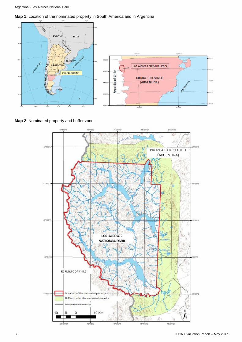
Argentina - Los Alerces National Park
Map 1: Location of the nominated property in South America and in Argentina
Map 2: Nominated property and buffer zone
86 IUCN Evaluation Report – May 2017

B. MIXED PROPERTIES B1. NEW NOMINATIONS OF MIXED PROPERTIES

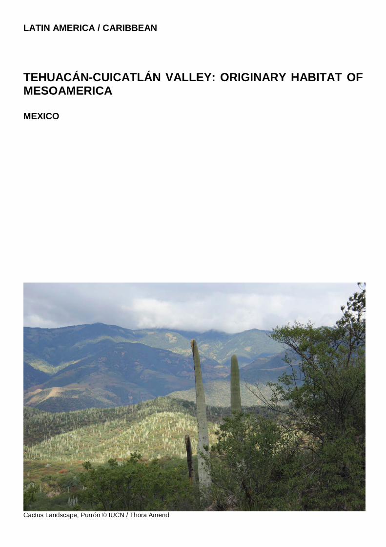
LATIN AMERICA / CARIBBEAN
TEHUACÁN-CUICATLÁN VALLEY: ORIGINARY HABITAT OF MESOAMERICA MEXICO
Cactus Landscape, Purrón © IUCN / Thora Amend

Mexico - Tehuacán-Cuicatlán Valley: originary habitat of Mesoamerica
WORLD HERITAGE NOMINATION – IUCN TECHNICAL EVALUATION
TEHUACÁN-CUICATLÁN VALLEY: ORIGINARY HABITAT OF MESOAMERICA (MEXICO) – ID N° 1534
IUCN RECOMMENDATION TO WORLD HERITAGE COMMITTEE: To defer the nomination under natural criteria. Key paragraphs of Operational Guidelines: Paragraph 77: Nominated property is part of an area that has the potential to meet World Heritage criteria. Paragraph 78: Nominated property does not meet integrity, protection and management requirements. 1. DOCUMENTATION a) Date nomination received by IUCN: 24 March 2016 b) Additional information officially requested from and provided by the State Party: ICOMOS engaged in dialogue with the State Party through a letter of 04 October 2016 ahead of the evaluation mission and a meeting with the State Party on 25 November 2016 during the course of its Panel meeting. The State Party responded formally to ICOMOS issues on 13 November 2016. Following their respective Panel meetings in late November and early December 2016, both Advisory Bodies sent a joint progress report to the State Party on 20 December 2016. This letter sought additional information on several issues, some specific to each of ICOMOS’s and IUCN’s evaluation roles, and some of joint concern to the evaluations of both Advisory Bodies. IUCN sought further information to confirm, through clear maps, that the attributes of the stated Outstanding Universal Value were within the nominated area and not within the buffer zone or wider regional setting. IUCN also sought additional information on a range of matters including the nature of local community involvement in management of the property; details of long-term budgets and staffing capacities; and more information on tourism planning and management in anticipation of increase in interest in the site. Two further letters were sent by the State Party on 30 January and again on 25 February 2017 in response to the supplementary information requests from both Advisory Bodies. c) Additional literature consulted: Various sources, including: Arias S., Gama-López S., Guzmán-Cruz L.U., and Vázquez-Benítez B. 2012. Flora del Valle de Tehuacán-Cuicatlán. Fascículo 95. CACTACEAE Juss. Instituto de Biología. Universidad nacional autóma de México. Barrera S.G., Pacheco J. and Ceballos G. 2004. La conservación de los reptiles y anfibios de México. CONABIO. Biodiversitas 57:1-6. Becerra J. 2005. Timing the origin and expansion of the Mexican tropical dry forest. PNAS 102(31): 10919-10923. BirdLife International. 2016a. Endemic Bird Area factsheet: Balsas region and interior Oaxaca. Downloaded from http://www.birdlife.org, accessed in November 2016. Casas A., Valiente-Banuet A., Viveros J.L., Caballero J., Cortés L., Dávila P., Lira R. and Rodríguez I. 2001. Plant resources of the Tehuacán-Cuicatlán Valley, Mexico. Economic Botany
55(1): 129-166. Contreras-Balderas S. and Almada-Villela P. 1996. Notropis imeldae / Notropis moralesi. The IUCN Red List of Threatened Species 1996: e.T14886A4468648 / T14890A4468980. Dávila, P., O. Téllez & R. Lira. 2012. Impact of climate change on the distribution of populations of an endemic Mexican columnar cactus in the Tehuacán-Cuicatlán Valley, Mexico. Plant Biosystems 147(2). Dávila, P., Del Coro Arizmendi M., Valiente-Banuet A., Villaseñor J.L., Casas A. and Lira R. 2002. Biological diversity in the Tehuacán-Cuicatlán Valley, Mexico. Biodiversity and Conservation 11: 421-442, 2002. Goettsch B., Hilton-Taylor C., Cruz-Piñón G. et al. 2015. High proportion of cactus species threatened with extinction. Nature Plants 15142. Pérez-Negrón, E., P. Dávila, and A. Casas. 2014. Use of columnar cacti in the Tehuacán Valley, Mexico: perspectives for sustainable management of non-timber forest products. J Ethnobiol Ethnomed. 2014; 10: 79. Ramírez-Pulido, J. and Martínez-Vázquez, J. 2007. Diversidad de los mamíferos de la Reserva de la Biosfera Tehuacán-Cuicatlán, Puebla-Oaxaca, México. Informe final SNIB-CONABIO proyecto No. BK022. México, D.F. Valiente-Banuet A. et al. 2000. La vegetación del Valle de Tehuacán. Bol. Soc. Bot. Mex. 67: 24-74. Vázquez, L., Moya, H. and Arizmendi, M. del C. 2009. Avifauna de la selva baja caducifolia en la cañada del río Sabino, Oaxaca, México. Revista Mexicana de la Biodiversidad 80: 535-549. Téllez Valdés O., Farías V., Dávila Aranda P., Stein J.L., Saade R.L., and Botello F.J. 2010. Mammalian diversity in climatic domains for Tehuacán-Cuicatlán Biosphere Reserve, Mexico. Revista Mexicana de Biodiversidad 81: 863-874. Vallejo M., Casas A.,Blancas J., Moreno-Calles A.I., Solís L., Rangel-Landa S., Dávila P., and Téllez O. 2014. Agroforestry systems in the highlands of the Tehuacán Valley, Mexico: indigenous cultures and biodiversity conservation. Agroforest Syst. 88:125-140. Villaseñor J. 2004. Los géneros de plantas vasculares de la flora de México. Bol. Soc. Bot. Méx. 75: 105-135. d) Consultations: 6 desk reviews received. The mission met with elected officials and representatives from the State Governments of Oaxaca and Puebla and consulted extensively with various officials, management staff and specialists responsible for the nominated property within the Comisión Nacional de Áreas Naturales Protegidas (CONANP) and the Instituto Nacional de Antropología e Historia (INAH). Consultation also occurred with the Cuicatlán Biosphere Reserve Foundation, Biosphere Reserve
IUCN Evaluation Report – May 2017 91
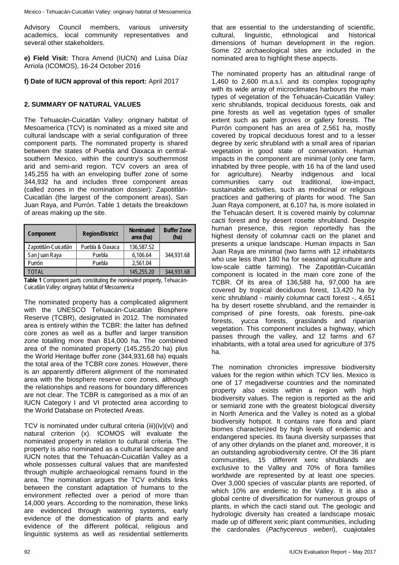
Mexico - Tehuacán-Cuicatlán Valley: originary habitat of Mesoamerica
Advisory Council members, various university academics, local community representatives and several other stakeholders. e) Field Visit: Thora Amend (IUCN) and Luisa Díaz Arriola (ICOMOS), 16-24 October 2016 f) Date of IUCN approval of this report: April 2017 2. SUMMARY OF NATURAL VALUES The Tehuacán-Cuicatlán Valley: originary habitat of Mesoamerica (TCV) is nominated as a mixed site and cultural landscape with a serial configuration of three component parts. The nominated property is shared between the states of Puebla and Oaxaca in central-southern Mexico, within the country’s southernmost arid and semi-arid region. TCV covers an area of 145,255 ha with an enveloping buffer zone of some 344,932 ha and includes three component areas (called zones in the nomination dossier): Zapotitlán-Cuicatlán (the largest of the component areas), San Juan Raya, and Purrón. Table 1 details the breakdown of areas making up the site.
Component Region/District Nominated area (ha)
Buffer Zone (ha)
Zapotitlán-Cuicatlán Puebla & Oaxaca 136,587.52 344,931.68 San Juan Raya Puebla 6,106.64
Purrón Puebla 2,561.04 TOTAL 145,255.20 344,931.68
Table 1 Component parts constituting the nominated property, Tehuacán-Cuicatlán Valley: originary habitat of Mesoamerica The nominated property has a complicated alignment with the UNESCO Tehuacán-Cuicatlán Biosphere Reserve (TCBR), designated in 2012. The nominated area is entirely within the TCBR: the latter has defined core zones as well as a buffer and larger transition zone totalling more than 814,000 ha. The combined area of the nominated property (145,255.20 ha) plus the World Heritage buffer zone (344,931.68 ha) equals the total area of the TCBR core zones. However, there is an apparently different alignment of the nominated area with the biosphere reserve core zones, although the relationships and reasons for boundary differences are not clear. The TCBR is categorised as a mix of an IUCN Category I and VI protected area according to the World Database on Protected Areas. TCV is nominated under cultural criteria (iii)(iv)(vi) and natural criterion (x). ICOMOS will evaluate the nominated property in relation to cultural criteria. The property is also nominated as a cultural landscape and IUCN notes that the Tehuacán-Cuicatlán Valley as a whole possesses cultural values that are manifested through multiple archaeological remains found in the area. The nomination argues the TCV exhibits links between the constant adaptation of humans to the environment reflected over a period of more than 14,000 years. According to the nomination, these links are evidenced through watering systems, early evidence of the domestication of plants and early evidence of the different political, religious and linguistic systems as well as residential settlements
that are essential to the understanding of scientific, cultural, linguistic, ethnological and historical dimensions of human development in the region. Some 22 archaeological sites are included in the nominated area to highlight these aspects. The nominated property has an altitudinal range of 1,460 to 2,600 m.a.s.l. and its complex topography with its wide array of microclimates harbours the main types of vegetation of the Tehuacán-Cuicatlán Valley: xeric shrublands, tropical deciduous forests, oak and pine forests as well as vegetation types of smaller extent such as palm groves or gallery forests. The Purrón component has an area of 2,561 ha, mostly covered by tropical deciduous forest and to a lesser degree by xeric shrubland with a small area of riparian vegetation in good state of conservation. Human impacts in the component are minimal (only one farm, inhabited by three people, with 16 ha of the land used for agriculture). Nearby indigenous and local communities carry out traditional, low-impact, sustainable activities, such as medicinal or religious practices and gathering of plants for wood. The San Juan Raya component, at 6,107 ha, is more isolated in the Tehuacán desert. It is covered mainly by columnar cacti forest and by desert rosette shrubland. Despite human presence, this region reportedly has the highest density of columnar cacti on the planet and presents a unique landscape. Human impacts in San Juan Raya are minimal (two farms with 12 inhabitants who use less than 180 ha for seasonal agriculture and low-scale cattle farming). The Zapotitlán-Cuicatlán component is located in the main core zone of the TCBR. Of its area of 136,588 ha, 97,000 ha are covered by tropical deciduous forest, 13,420 ha by xeric shrubland - mainly columnar cacti forest -, 4,651 ha by desert rosette shrubland, and the remainder is comprised of pine forests, oak forests, pine-oak forests, yucca forests, grasslands and riparian vegetation. This component includes a highway, which passes through the valley, and 12 farms and 67 inhabitants, with a total area used for agriculture of 375 ha. The nomination chronicles impressive biodiversity values for the region within which TCV lies. Mexico is one of 17 megadiverse countries and the nominated property also exists within a region with high biodiversity values. The region is reported as the arid or semiarid zone with the greatest biological diversity in North America and the Valley is noted as a global biodiversity hotspot. It contains rare flora and plant biomes characterized by high levels of endemic and endangered species. Its fauna diversity surpasses that of any other drylands on the planet and, moreover, it is an outstanding agrobiodiversity centre. Of the 36 plant communities, 15 different xeric shrublands are exclusive to the Valley and 70% of flora families worldwide are represented by at least one species. Over 3,000 species of vascular plants are reported, of which 10% are endemic to the Valley. It is also a global centre of diversification for numerous groups of plants, in which the cacti stand out. The geologic and hydrologic diversity has created a landscape mosaic made up of different xeric plant communities, including the cardonales (Pachycereus weberi), cuajiotales
92 IUCN Evaluation Report – May 2017
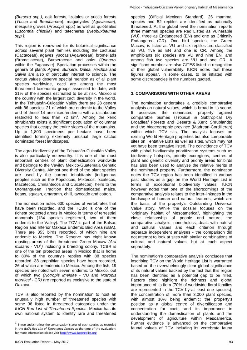
Mexico - Tehuacán-Cuicatlán Valley: originary habitat of Mesoamerica
(Bursera spp.), oak forests, izotales or yucca forests (Yucca and Beaucarnea), magueyales (Agavaceae), mesquite groves (Prosopis spp.) as well as quiotillales (Escontria chiotilla) and tetecheras (Neobuxbaumia spp.). This region is renowned for its botanical significance across several plant families including the cactuses (Cactaceae), agaves, yuccas (Agavaceae), bromeliads (Bromeliaceae), Burseraceae and oaks (Quercus within the Fagaceae). Speciation processes within the genera of plants Agave, Bursera, Dalea, Hechtia and Salvia are also of particular interest to science. The cactus values deserve special mention as of all plant species worldwide, cacti are among the most threatened taxonomic groups assessed to date, with 31% of the species estimated to be at risk. Mexico is the country with the largest cacti diversity in the world. In the Tehuacán-Cuicatlán Valley there are 28 genera with 86 species, 21 of which are endemic to the Valley and of these 14 are micro-endemic with a distribution restricted to less than 72 km2. Among the xeric shrublands exists a significant population of columnar species that occupy the entire slopes of the mountains. Up to 1,800 specimens per hectare have been identified forming extremely unusual large cactus dominated forest landscapes. The agro-biodiversity of the Tehuacán-Cuicatlán Valley is also particularly noteworthy. It is one of the most important centres of plant domestication worldwide and belongs to the Vavilov Mexico-Guatemala Genetic Diversity Centre. Almost one third of the plant species are used by the current inhabitants (indigenous peoples such as the Popolocas, Mixtecos, Ixcatecos, Mazatecos, Chinantecos and Cuicatecos), heirs to the Otomanguean Tradition that domesticated maize, beans, squash, amaranth, chilli, avocado and cotton. The nomination notes 630 species of vertebrates that have been recorded, and the TCBR is one of the richest protected areas in Mexico in terms of terrestrial mammals (134 species registered, two of them endemic to the Valley). The TCV is part of the Balsas Region and Interior Oaxaca Endemic Bird Area (EBA). There are 353 birds recorded, of which nine are endemic to Mexico. The Reserve has eight known roosting areas of the threatened Green Macaw (Ara militaris - VU1) including a breeding colony. TCBR is one of the ten protected areas in Mexico that is home to 80% of the country’s reptiles with 88 species recorded. 38 amphibian species have been recorded, 26 of which are endemic to Mexico. Among the fish, 19 species are noted with seven endemic to Mexico, out of which two (Notropis imeldae - VU and Notropis moralesi - CR) are reported as exclusive to the state of Oaxaca. TCV is also reported by the nomination to host an unusually high number of threatened species with some 38 listed in threatened categories under the IUCN Red List of Threatened Species. Mexico has its own national system to identify rare and threatened
1 These codes reflect the conservation status of each species as recorded in the IUCN Red List of Threatened Species at the time of the evaluation; for more information please visit http://www.iucnredlist.org
species (Official Mexican Standard). 26 mammal species and 52 reptiles are identified as nationally threatened. At the global level the nomination reports three mammal species are Red Listed as Vulnerable (VU), three as Endangered (EN) and one as Critically Endangered (CR). One bird species, the Green Macaw, is listed as VU and six reptiles are classified as VU, five as EN and one is CR. Among the amphibians six species are VU and nine EN, and among fish two species are VU and one CR. A significant number are also CITES listed in recognition of their global vulnerability. IUCN notes that these figures appear, in some cases, to be inflated with some discrepancies in the numbers quoted. 3. COMPARISONS WITH OTHER AREAS The nomination undertakes a credible comparative analysis on natural values, which is broad in its scope. It assesses the nominated property against comparable biomes (Tropical & Subtropical Dry Broadleaf Forests and Deserts & Xeric Shrublands) and the biogeographic province (Madrean-Cordilleran) within which TCV sits. The analysis focuses on existing World Heritage properties but also comparable sites on Tentative Lists as well as sites, which may not yet have been tentative listed. The coincidence of TCV with global biodiversity prioritization systems such as biodiversity hotspots, priority ecoregions, centres of plant and genetic diversity and priority areas for birds has also been used to analyse the relative merits of the nominated property. Furthermore, the nomination notes the TCV region has been identified in various past studies as a gap on the World Heritage List in terms of exceptional biodiversity values. IUCN however notes that one of the shortcomings of the comparative analysis relates to the inter-linkages in the landscape of human and natural features, which are the basis of the property’s Outstanding Universal Value story. While the dossier focuses on the “originary habitat of Mesoamerica”, highlighting the close relationship of people and nature, the comparative analysis, nonetheless, deals with natural and cultural values and each criterion through separate independent analyses - the comparison did not attempt to look at sites with similar combinations of cultural and natural values, but at each aspect separately. The nomination’s comparative analysis concludes that inscribing TCV on the World Heritage List is warranted based on the overwhelmingly clear global significance of its natural values backed by the fact that this region has been identified as a potential gap to be filled. Factors cited highlight the richness and global importance of its flora (70% of worldwide floral families are represented in the TCV by at least one species); the concentration of more than 3,000 plant species, with almost 10% being endemic; the property’s position as a global centre of diversification and concentration for cacti; and its importance in understanding the domestication of plants and the development of agriculture within Mesoamerica. Further evidence is advanced on the comparative faunal values of TCV including its vertebrate fauna
IUCN Evaluation Report – May 2017 93
Mexico - Tehuacán-Cuicatlán Valley: originary habitat of Mesoamerica
which is claimed to surpass that of any other dryland in the world; its exceptional species diversity, especially for reptiles and amphibians; and its high numbers of endemic and threatened species. IUCN, in collaboration with UN Environment WCMC, has undertaken supplementary comparative analysis, which confirms much of the evidence outlined above. However, a crucial issue in relation to the evaluation is that these findings are based on data in many cases from the larger biosphere reserve or wider region and it is not always clear from the nomination file if these numbers apply to the nominated property, to the whole Valley, or to TCBR. The analysis concludes that the biodiversity of the region, within which the nominated property occurs, appears to be of global significance based on the spatial analyses and literature review, both with regards to criteria (ix) and (x), but is not able to substantiate that the actual nominated property is a fully appropriate representation of these wider values. Efforts to clarify this issue with the State Party through supplementary information have also not provided any additional convincing evidence on this matter. TCV is not nominated for criterion (ix), however, IUCN confirms it is situated in the arid and semiarid zone with the greatest biological diversity in North America. It is also part of three ecoregions (Balsas Dry Forests, Tehuacán Valley Matorral and Sierra Madre del Sur Pine-Oak Forests) which are not yet represented on the World Heritage List, and over 70% of the nominated property is also found in the Southern Mexican Dry Forests priority ecoregion which has no existing World Heritage site to date. Finally, it is also part of a Centre for Plant Diversity and an Endemic Bird Area, and the region has been identified as representing a potential gap in the World Heritage List in various past studies. Concerning criterion (x), the analysis supports the claims that this region sustains high levels of plant biodiversity including cacti, agaves, yuccas, bromeliads, bursera and oaks. Furthermore, it hosts one of the highest animal biodiversity levels in a dryland, at least with regard to some taxa such as amphibians, reptiles and birds. There is also a very high level of endemism, both among plant and animal species (including rodents, reptiles and birds), as well as several globally threatened species. The TCBR, which encloses the nominated property, is listed amongst the top 0.20% most irreplaceable protected areas in the world for the survival of threatened species. TCBR encompasses over 10% of the global distribution range of four amphibian species, and is ranked as one of the two most important protected areas in the world for the conservation of seven amphibian and three bird species. In summary, it is very evident that TCV exists within a region of extremely significant global biodiversity importance; however, it is not clear if the values ascribed to the nominated property are found within its boundaries or in the larger TCBR. This concern was raised early in the evaluation by IUCN, and included in the request for supplementary information of December 2016 was a specific request to verify the
spatial distribution of key attributes in the nominated property. However, additional evidence and clear mapping was unfortunately not forthcoming from the State Party to improve the confidence levels in the available data. 4. INTEGRITY, PROTECTION AND MANAGEMENT 4.1. Protection The nominated property is part of an area designated in 1998 by the Mexican Federal Government as a national biosphere reserve in accordance with the Mexican General Law of Ecological Balance and Environmental Protection (LGEEPA). In 2012, the national Tehuacán-Cuicatlán Biosphere Reserve became a UNESCO Biosphere Reserve. The LGEEPA law guarantees effective legal protection for the nominated property and directed the preparation of a management plan for TCBR with objectives to preserve the biodiversity of the Floristic Province of Tehuacán-Cuicatlán, thus maintaining the continuity of the ecological and evolutionary processes that take place in the area, as well as preserving the associated cultural and historical heritage. The management framework and legal protection seem adequate and interactions with the wider landscape and connectivity needs are being taken into account in ensuring the adequate protection of the biosphere reserve. Almost all the nominated property (98.5%) is classed as “ejidos” with a small area (1.5%) consisting of private lands. In Mexico, ejidos are agrarian communities constituted with a minimum of 20 members that are granted with land needed for subsistence by presidential executive order. Communities are groups of people, whether indigenous or agrarian, that possesses land of collective use and exploitation. The evaluation mission did not consider land tenure to be a major problem within the property. IUCN considers that the protection status of the nominated property meets the requirements of the Operational Guidelines, but is concerned that the overlaps with implementation of the TCBR remain unclear. 4.2 Boundaries As noted above, the nominated property and the proposed World Heritage buffer zone is within the TCBR. The nominated area comprises 29.6% of the core and buffer zone area of the TCBR. The larger transition zone of the biosphere reserve provides a good degree of graded protection for the site. According to the dossier, the three components of the property were selected considering criteria of representativeness and ecological integrity, threat level, as well as for their legal protection and functional management. The nomination dossier adds that such components have been selected to maintain landscape, ecological, evolutionary and habitat connectivity and, as a whole, include all the
94 IUCN Evaluation Report – May 2017
Mexico - Tehuacán-Cuicatlán Valley: originary habitat of Mesoamerica
biodiversity elements that convey the natural Outstanding Universal Value. However, the maps provided in the nomination dossier make it difficult to work out the extent of the components of the nomination property and their overlap with the core zones of the TCBR and IUCN is not yet clear that all the elements necessary to express the stated Outstanding Universal Value are indeed inside the nominated area as required by paragraph 88 of the Operational Guidelines. The two smaller components of San Juan Raya and Purrón appear to be within the TCBR buffer zone, not its core zone. Supplementary information provided by the State Party has not helped to clarify this fundamental point. The three components of the nominated property share the same single buffer zone which appears is of an adequate size to provide an additional layer of protection to the component parts. The buffer zone also facilitates habitat connectivity between the three component parts and beyond, whilst also accommodating the sustainable use of certain zones within the TCBR. The southern end of the nominated area comprises a biological corridor between the Mazateca, Juárez and Mixteca Mountain Ranges, which facilitates the movement of mammal species as well as birds and reptiles. Here, the landscapes are in an excellent state of conservation and contain relevant and fragile ecosystems. This region also comprises the Cañon del Sabino, an important nesting area for one of the most stable and well-conserved populations of the highly threatened Green Macaw. IUCN considers that the boundaries of the nominated property do not meet the requirements of the Operational Guidelines, notably in view of the lack of justification of boundaries in relation to the relevant attributes. 4.3 Management In general, an effective and well-established management system is in place for the natural values of the TCBR: one which has had time to mature during the 18 years since the creation of the national biosphere reserve. The management of natural heritage is primarily through CONANP, with cultural heritage and archaeological aspects having more recently engaged INAH in the context of the mixed site nomination. CONANP has provided good quality management of the natural values, however, the degree to which an integrative approach to managing natural and cultural issues assets has developed, remains limited. CONANP is a well-respected management authority and relationships between their staff, local authorities and the local population seem to be characterized by mutual respect and trust. However, the system is still evolving when it comes to participatory approaches which empower local communities in planning and decision-making. The regional governments in both provinces (Puebla and Oaxaca) show great interest in coordinating planning and actions with the TCBR, thus providing a positive surrounding context.
There is also a reasonably comprehensive planning framework for the nominated property including sectoral plans at federal level which direct programmes around urban and rural development, water, food security, climate change and tourism etc. Similar plans exist at regional and municipal levels where relevant, and these have varying degrees of influence on the property and its management. The TCBR includes a management plan, which was developed in 2012 and, according to the nomination dossier, will be updated soon, in coordination with the INAH, to strengthen and guarantee the protection of the natural and cultural assets that confer the Outstanding Universal Value to the property. A weakness in the management system relates to governance which is considered still relatively top-down. IUCN notes the attempts to enhance participation, yet recommends more attention be given to progressively improving the governance structure for the nominated property to further recognise traditional knowledge and management systems; give voice to local communities and empower them in decision-making on research, conservation and restoration. Fostering these governance reforms would assist in better integrating the management of natural and cultural heritage in the TCV. An important contribution in the region comes from the “Fundación Reserva de Biosfera” founded in 1997. The Foundation undertakes positive conservation work (e.g. environmental education and communication, or establishing nurseries for endemic plants and agave seedlings, which later are given to the mezcal-producing communities for reforestation activities). Skilful management of the Foundation will be necessary to ensure it plays an ongoing positive role in the site and is appreciated by all stakeholders. Apart from research and outreach, IUCN recommends the State Party work with the Foundation to foster community-driven management programs for natural resources that support entrepreneurial skills, and thus enhance diversified and balanced governance structures for the site. The TCBR has a staff of 15 permanent positions, including the Director, professionals (biologists, agricultural engineers, geographer, veterinary technician) and logistical support staff. Staff numbers are low given the size of the TCBR and their responsibilities. Staff stability is also a problem as CONANP has limited the possibility of offering long-term contracts. The professional qualifications and motivation of staff is nevertheless high and CONANP offers good training opportunities. Staffing limitations have in part driven initiatives to establish communal brigades within all local villages in the reserve; teams of 10 to 20 men and women have been appointed to provide surveillance, monitoring, and fire suppression. They seem quite well organized and equipped, motivated and trained in various aspects and receive a modest payment which is part of a state programme of income generation in communities with high poverty levels. This is a mutually beneficial arrangement, provided the balance of paid government staff balances the use of the communal brigades. IUCN
IUCN Evaluation Report – May 2017 95
Mexico - Tehuacán-Cuicatlán Valley: originary habitat of Mesoamerica
encourages the maintenance of this program, ensuring its long-term political and financial support. The Biosphere Reserve is currently clearly underfunded, but interest from Federal and State authorities in the potential of World Heritage listing has resulted in pledges of increased funding. However, no concrete figures or reliable financial / budgetary information for 2016 could be obtained during the field mission. The dossier mentions the finances available for 2015, assuming that 2016 would receive similar amounts of money. This indicates funding from a range of government and project sources totalling MXN 8,867,000 (approx. USD 472,000). The State Party in supplementary information provided some additional budget information for 2016 showing an increase in overall funding which is positive. IUCN notes one of the specific objectives of the management plan is to guarantee its implementation as well as to design and implement a financing strategy to cover these costs. However, the strategy for, and security of, long-term funding for the nominated property is not clear. The dossier states that Mexico is currently initiating a major National Monitoring System of Biodiversity and Ecosystemic Degradation. This is a positive development, which will hopefully trigger improved participatory monitoring programmes for the TCV. IUCN considers that the management of the nominated property does not meet the requirements of the Operational Guidelines. 4.4 Community The mission assessed the impact of the World Heritage nomination and potential inscription as being either positive or not changing the existing situation with respect to communities and their rights. World Heritage listing would not change land tenure rights and may improve the access to information, levels of consultation and consent for local people. However, given the understaffed situation in TCBR and remoteness of some areas, this could be difficult to accomplish. Listing could increase the decision-making rights of locals but this is tied up in governance reforms as discussed above. The mission did not detect any opposition from local people to the nomination. 77 people are noted as living in the nominated property with a further 36,628 people residing in the buffer zone. Livelihood opportunities and benefit-sharing could be improved through a World Heritage Listing although experience suggests this will only happen if actively facilitated through the authorities. Optimizing benefits should be done in full knowledge of the overall economic context and aspirations of local people. Local people are organized and represented on the Biosphere Reserve Advisory Council, where their elected representatives ensure participation in decision-making processes. Communal Brigades are a relatively new initiative and participate actively in some
aspects of management. Staff of the TCBR work to catalyse local engagement and reinforce local traditions. That said, participatory approaches appear to be more about informing and consulting the community rather than acting together and more could be done to integrate traditional ecological knowledge into natural resource management. 4.5 Threats In comparison to other regions, current and potential threats are quite low, since the population density is low and there is a trend of emigration. Nevertheless, the lack of personnel and funding is hampering the ability to manage a range of threats to the nominated property which include illegal trafficking of cacti, extraction of agave and natural resources for fuel and other purposes, hunting, overgrazing, deforestation, as well as secondary road impacts. Extensive goat farming is commonly practiced across much of the property and its buffer zone. It is responsible for soil compaction and deterioration, destroying original vegetation and hindering its regrowth due to the feeding habits of goats, whose diet consists of almost all types of plants. Despite the potential for serious impact, the IUCN field mission did not perceive this as affecting the site to a severe degree at present. Until now there have been low numbers of visitors to the TCBR, in the order of 20,000 visitors per year. However, no exact numbers are available and despite the fact that CONANP has developed a Nature Tourism Strategy for the TCBR (Puebla-Oaxaca 2010-2015), this document up to now does not seem to have influenced the management of the area. As recognized in the nomination dossier, the UNESCO label can bring a higher influx of visitors, thus requiring an effective up to date tourism strategy developed with the participation of all the stakeholders. The Tourism Strategy should be revised to define carrying capacity for strategic sites, develop marketing strategies, plan interpretation and train locals as tour guides or small entrepreneurs to ensure they benefit from potential World Heritage listing. Impacts of climate change on the TCV are becoming evident. This karst region suffers from lack of water and irrigation systems and hydraulic schemes have played a decisive role for past developments of the region. If drought phases and episodic torrential rains increase, this might lead to additional erosion (in some parts already quite visible) and put the fragile ecosystems, the archaeological sites, as well as local populations under additional stress. Climate modelling indicates varying scenarios which could see the forests of columnar cacti contracting by possibly 50% based on changes to precipitation and seasonal temperatures. This extent of ecological change is extremely concerning given the small size of two of the nominated components and the fragmentation caused by the highway and secondary roads crossing the valley. Further research is encouraged to understand these potential changes and develop management responses.
96 IUCN Evaluation Report – May 2017
Mexico - Tehuacán-Cuicatlán Valley: originary habitat of Mesoamerica
Other impacts, more so in the buffer zone, include the inadequate management of solid waste and water, and soil and air contamination arising from poor management of poultry and pig farms which create point sources of contamination for the property. Other threats include the extraction of animal and plant species (the legacy of collecting rare species of agave and cactus for science and commercial purposes); illegal hunting by locals; mezcal production and extraction of fire wood and of agave (traditional production of mezcal liquor, made from agave, and the use of dry parts of vegetation for stoves). Whilst still of concern, these threats appear to be under control due to good management programmes run by the authorities and other partners. For example, the Cuicatlán Biosphere Reserve Foundation supports nurseries for agave seedlings in some communities, reducing collecting pressure on wild populations. In conclusion, IUCN considers that the integrity requirements of the Operational Guidelines are not met due to uncertainty about the elements of Outstanding Universal Value being within the nominated area. The protection and management requirement fo the Operational Guidelines are also not fully met. 5. ADDITIONAL COMMENTS 5.1 Justification for Serial Approach When IUCN evaluates a serial nomination, it asks the following three questions: a) What is the justification for a serial approach? The nomination dossier does not specifically spell out the justification for a serial approach except to imply that the component areas represent the places which best represent the stated Outstanding Universal Value (including archaeological “highlights”) and which are in the best condition: in the case of natural values those areas with the least impact and threat, and therefore good integrity. The mission confirmed that, whilst the connecting buffer zone is of similar vegetation, the three components encompass good quality vegetated areas of the Tehuacán-Cuicatlán Valley. What is not clear is if these areas also encompass the full range of other natural value attributes of the stated Outstanding Universal Value. b) Are the separate component parts of the nominated property functionally linked in relation to the requirements of the Operational Guidelines? From the point of view of the natural values the serial configuration is ecologically linked by the good connectivity afforded by the much larger enveloping buffer zone which broadly aligns with the core and buffer zone of the TCBR. This ensures continuity of ecological processes and room for the continued development of ecological processes and critical habitats. Nevertheless, IUCN has concerns about the integrity of ecological processes within the two smaller components which appear to implicate areas outside the core zones of the TCBR. There are further
concerns regarding the functional linkages between the natural and cultural values of the TCV and how these present a coherent and integrated overall case for Outstanding Universal Value linking the individual sites and features. This is further discussed in 5.2 below. c) Is there an effective overall management framework for all the component parts of the nominated property? All three component areas form part of the TCBR which places them under a common legal framework and a single management system. The good inter-institutional coordination of CONANP (protected areas) and INAH (anthropology and archaeology) has only started recently in the context of the nomination process and preparation of the dossier. Both institutions see joint learning and the integration of management aspects as an important opportunity bought about by this nomination and are committed to use this site as a first case of integrated management of a mixed World Heritage site in Mexico. The preparation of a joint declaration of both institutions, reflecting this intention, is at present underway (Memorandum of Understanding). IUCN commends this intention, however, notes that nearly all institutional, policy and managerial aspects remain separated in terms of conservation of nature and culture and there is limited integration at present. It will be critical to continue to work toward the goal of stronger, long-term integration between nature and culture in the site. 5.2 Mixed site configuration The property has been nominated as both a mixed site and a cultural landscape. Paragraph 47 of the Operational Guidelines notes that “cultural landscapes are cultural properties and represent the ‘combined works of nature and of man’ designated in Article 1 of the Convention. They are illustrative of the evolution of human society and settlement over time, under the influence of the physical constraints and/or opportunities presented by their natural environment and of successive social, economic and cultural forces, both external and internal”. IUCN is concerned as to how the natural and cultural values of the nomination are intertwined to articulate a clear and cohesive Outstanding Universal Value story for the nominated property. The 22 archaeological sites included in the dossier are mostly discussed as stand-alone features, not in their natural context, or in terms of their co-evolution / dependencies on the natural setting. The nomination dossier suggests that exceptional biodiversity has led to great cultural diversity. This cultural diversity is argued to be reflected in archaeological remains, languages and pictographic evidences, technical innovations driven by adaptation to the harsh arid and semi-arid climate, leading to the domestication of wild plant species and development of the region as one of the important Vavilov centres of agro-biodiversity. However, in the field, the close interaction of humans with nature is only visible to the trained eye, as most features and infrastructure (like channels and Purrón
IUCN Evaluation Report – May 2017 97
Mexico - Tehuacán-Cuicatlán Valley: originary habitat of Mesoamerica
dam) have been reclaimed by natural succession. IUCN recommends further fundamental reflection on how linkages in the landscape can be identified, presented and better managed in an integrated fashion. 6. APPLICATION OF CRITERIA Tehuacán-Cuicatlán Valley: originary habitat of Mesoamerica has been nominated under natural criterion (x) as well as under cultural criteria (iii), (iv) and (vi) which will be evaluated by ICOMOS. Criterion (x): Biodiversity and threatened species The overall Tehuacán-Cuicatlán Biosphere Reserve stands out as remarkable for its species richness and levels of endemism, as well as for the protection of threatened species and its contribution to global agro-biodiversity. The Tehuacán-Cuicatlán Valley is the arid and semiarid zone with the greatest biological diversity in North America. A remarkable 70% of worldwide floral families are represented in the Valley, by at least one species, and the area is one of the main centres of diversification for the cacti family, which is highly threatened worldwide. A remarkable diversity of cacti exists within the Valley often in exceptional densities of up to 1,800 columnar cacti per hectare. The area exhibits particularly high diversity among other plant types, namely the agaves, yuccas, bromeliads, bursera and oaks. Worldwide, it hosts one of the highest animal biodiversity levels in a dryland, at least with regard to taxa such as amphibians, reptiles and birds. The nominated property sits within one of the most important protected areas worldwide for the conservation of threatened species encompassing over 10% of the global distribution range of four amphibian species, and is ranked as the one of the two most important protected areas in the world for the conservation of seven amphibian and three bird species. The biodiversity of this region has a long history of sustaining human development and today a third of the total diversity of the Valley (approx. 1,000 species) are used by local people. However, as proposed, the nomination is deficient in relation to demonstrating how the specific nominated property addresses these values in the wider area of the Biosphere Reserve, and all of its zones. Furthermore, there is limited justification and evidence regarding key interactions between natural and cultural diversity that is claimed in the nomination, and the rationale for the mixed site approach that is proposed. IUCN considers that the nominated property has potential to meet this criterion, subject to further reflection on the mixed site approach and confirmation that the key natural values are within the boundaries of the nominated area.
7. RECOMMENDATIONS IUCN recommends that the World Heritage Committee adopts the following draft decision, noting that this will be harmonised as appropriate with the recommendations of ICOMOS regarding their evaluation of this mixed site nomination under the cultural criterion and included in the working document WHC/17/41.COM/8B: The World Heritage Committee, 1. Having examined Documents WHC/17/41.COM/8B and WHC/17/41.COM/INF.8B2; 2. Defers Tehuacán-Cuicatlán Valley: originary habitat of Mesoamerica (Mexico), in relation to natural criteria, taking note that the region has biodiversity values that are potentially of Outstanding Universal Value, to allow the State Party, with the support of the Advisory Bodies if requested, to:
a) Review the nomination to clearly demonstrate that all natural attributes contributing to the potential Outstanding Universal Value are included within the serial components and boundaries of the nominated property, harmonizing wherever possible the core zones of the Tehuacán-Cuicatlán Biosphere Reserve with the nominated area;
b) Clearly articulate how the nominated property presents a coherent relationship between its cultural and natural values consistent with the provisions of the Operational Guidelines;
c) Provide evidence of adequate, sustainable funding and appropriately skilled staff for holistic, integrated management of natural and cultural heritage values within the nominated property; and
d) Consider including criterion (ix) in a revised nomination, in view of the global ecological significance of the region within which the nominated property is located.
3. Encourages the State Party to expedite its plans to update the Nature Tourism Strategy for the Tehuacán-Cuicatlán Biosphere Reserve (2010-2015) to improve visitor management strategies including defining carrying capacities; to identify suitable private sector tourism partners; to define appropriate tourism infrastructure; and to build the capacities of local communities and other sectors to handle increasing tourism interest in the nominated property. 4. Further encourages the State Party to refine the governance structure of the nominated property to involve more effective participation of local communities in co-management and decision-making, and ensure the economic needs and development aspirations of these communities are appropriately addressed.
98 IUCN Evaluation Report – May 2017
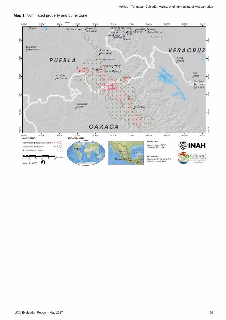
Mexico - Tehuacán-Cuicatlán Valley: originary habitat of Mesoamerica
Map 1: Nominated property and buffer zone
IUCN Evaluation Report – May 2017 99


C. CULTURAL PROPERTIES C1. NEW NOMINATIONS OF CULTURAL PROPERTIES


AFRICA
‡KHOMANI CULTURAL LANDSCAPE SOUTH AFRICA

South Africa – ǂKhomani Cultural Landscape
WORLD HERITAGE NOMINATION – IUCN COMMENTS TO ICOMOS
‡KHOMANI CULTURAL LANDSCAPE (SOUTH AFRICA)
IUCN provides the following brief comments to ICOMOS based on a review of the nomination by the World Heritage Panel, a field mission report and 3 desk reviews. The nomination comprises the entire area of the Kalahari Gemsbok National Park (KGNP) (https://www.protectedplanet.net/874 - IUCN protected area category not specified). The total area of the nominated property is reported as 959,100 ha, with no buffer zone. The nominated area forms, with the adjacent area of Gemsbok National Park (GNP) to the north in Botswana, the Kgalagadi Transfrontier Park (KTP - c 3.6 million ha) with an unfenced boundary between the two parks. To the west, the property is abruptly truncated by the North-South straight line boundary of the border with Namibia, and in Namibia the area comprises game and commercial farms. To the south, KGNP has a fenced border, and adjoins a landscape that is under mixed uses (farming, wildlife ranching, tourism development, villages), which are not intensive. Land use is governed in this area through a system of territorial plans. No buffer zone has been proposed for the property; the KTP provides a direct buffering function to the north, but otherwise the buffering functions are limited. Nature conservation values of the nominated property The nominated property is not nominated under natural criteria, and IUCN has not made a specific assessment of its nature conservation values. The nature conservation values are reported via a short section in the nomination to be significant due to the large intact protected ecosystem of KGNP, and the wider KTP which has been strongly protected from illegal uses and intensive development. It is not clear that these values are at the level sufficient to have considered the application of biodiversity criteria (criteria ix and x), but this could be further considered to see if there might be potential. Neither of the two component parks of KTP has been identified amongst the world’s most irreplaceable protected areas for the protection of threatened species; nevertheless a rapid analysis suggests the presence of a range of threatened species and the presence of a large scale and intact functioning ecosystem, including top predators, which is of international conservation significance. Review information suggests that the wider landscape to the south of the property, which, as discussed below (boundaries), is a crucial element of the ‡Khomani Cultural Landscape, has suffered from threats. According to elders, historically the whole of the Kalahari used to be lusher when it was unfenced and migration followed natural patterns. Poaching, possibly including threatened tortoise species and pangolin, is also reported outside KGNP, mainly by outsiders but with some past (early 2000s) reports involving officials. The current situation requires further consideration with the State Party. Fencing is a further notable problem to the south-west of the property with a direct impact on migration routes. Nature/culture values The IUCN evaluation and desk reviewers confirm the importance of the connection between the ‡Khomani San people and nature, both due to a high degree of reliance on natural resources, and as a source of community identity. This connection was severed in the nominated property in 1930 when the ‡Khomani San were forcibly removed from the land on the creation of the National Park, and the basis of the nomination is the reestablishment of the connection with nature since the colonial and apartheid period. Their re-emergence is closely linked to knowledge of nature, an historical connection with the territory in and around the nominated property, and economic opportunities associated with landscape and biological knowledge. Despite displacement, remarkable ecological knowledge has persisted and the potential to re-establish intergenerational connections between people and place is real. This is the last original San community in South Africa, and notable for the detail of documentation and the sustained presence on the land and the intergenerational transmission of cultural and language. There has been intergenerational training and passing of knowledge as part of the return of traditional lands. But this is also a fragile situation, and the implementation of a possible World Heritage nomination needs to be addressed to supporting and nurturing these connections. It is paradoxical that whilst there was clear and inexcusable damage to the ‡Khomani San from their displacement from KGNP, the fact of conservation of nature achieved by the Park also now creates the opportunity to re-establish nature-culture connections for the ‡Khomani San people, provided that the KGNP and its surrounding area is managed in a way that can support and empower the recreation of those connections, and that necessary support is provided to the communities. Reviews also note the importance of assuring that changes to traditional use, including the introduction and management of livestock, are approached with great care to avoid damage to the values of
IUCN Evaluation Report – May 2017 105
South Africa – ǂKhomani Cultural Landscape
KGNP. A further key question is how the transition to sedentarism may impact the cultural aspects of the nomination. Analysis of human-wildlife conflicts currently and in the future re livestock-wildlife interactions need to be understood. One area of concern to IUCN is that it is noted that many of the nature-culture associations of the ‡Khomani San people are intangible, and there is absence of tangible cultural remains (e.g. rock art) – this creates the same risk of limitations imposed by the World Heritage Convention’s criteria, and the separate treatment of natural and cultural criteria for values that are about the intimate relationship of people living for millennia in harmony with nature, but without significant physical evidence resulting. The possible artificial separation of tangible and intangible heritage may also be problematic. Although (unlike the situation with the nomination of Pimachiowin Aki, Canada) this nomination is for a Cultural Landscape, and not a Mixed Site, it may be important in view of the very notable nature conservation values of the property, that IUCN and ICOMOS should work particularly closely in providing feedback and discussing options with the nominating State Party, and the communities, rightholders and stakeholders who are participating in this nomination. Boundaries A crucial issue in the nomination appears to revolve around boundaries. IUCN reviews note that large areas of the landscape that represents the ‡Khomani relationship with the land, including the places where the ‡Khomani live, areas of nature conservation significance and areas that are cultural sites, is outside the National Park. Whilst much of this land is owned by non-San private owners, and thus potentially difficult to include in an inscribed area, it seems essential that this area should be more clearly considered as intrinsic to the identification, definition and protection and management of the relationship between the ‡Khomani San people and nature. This is a matter that ICOMOS should consider in more detail with the State Party, and IUCN will be willing to also further contribute to these discussions. The functioning of buffer arrangements to the south of the property (and transboundary arrangements with Namibia which are little mentioned in the nomination) could also be considered further. Governance, protection and management KGNP appears to IUCN to be an effectively managed national park in terms of the task of the conservation of nature. Whilst staffing could be further increased, the current staff is professional and effective, and the park has both a strong level of legal protection, and apparent relatively low levels of threat. As a large area, it appears, particularly in the wider context of KTP, to be delivering effective conservation results. The nomination makes little reference to governance but this appears to be an essential aspect of the nomination, in particular in relation to the participation of the ‡Khomani San in the nomination, and the management of the property. IUCN considers that more attention should be given to the existing and intended governance structures, and to define the body/bodies that would be involved in decision taking and how any conflicts would be resolved. It should be clearer how all the different stakeholders and rights-holders will be able to engage with each other to assure their sustained relationships with the nominated property. The IUCN field mission noted the commitment of KGNP to community participation, which entails a Joint Management Board (JMB) and provision for cultural use in different zones within the property. As the result a land claim process part of KGNP has been passed back to full ownership by the Community. The mission further took time, to the extent possible, to verify that there was strong community support, and that appropriate representatives of the community had been met. The participation of the ‡Khomani in the management of the property remains still at an early stage and needs to be accorded progressive support. The IUCN mission noted that there will be room to improve the functioning of the JMB over time, so that communities are not only consulted but empowered and supported to take a greater role in management and leadership. This will rely on the building of capacity, supporting training needs and intergenerational transfer of knowledge, and the continuation of the evident commitment of the staff of SANParks in this regard. Within and beyond the nominated property, the ‡Khomani San community is rich in cultural heritage – both tangible and intangible – but is in a state of chronic poverty and unemployment, and vulnerable to prejudice. It is not a traditional society with robust traditional authority, but a diverse, resettled group of people whose institutions have been weakened by past treatment. ICOMOS should pay particular attention to interrogating the nomination to see how these issues of institutional fragility, human rights vulnerability, and a history of sustained discrimination and poverty are to be dealt with. These matters need approaches that are not the primary responsibility of KGNP, but require a focus in the area where the communities live (notably to the south of the property). Issues include the provision of education; for instance schools do not teach in the mother tongue, Khoekhoegowab, to those that speak it and there are no qualified San school teachers and no integration of traditional ecological knowledge into curricula. There are low tourism numbers at present, so development in this sector needs to be established on the basis of shared benefits with the community and to ensure tourism supports cultural and natural heritage. Training and capacity building needs to be supported, in appropriate ways to enable transgenerational learning and opportunities. The capacity building and economic livelihood strategy needs to be clearly defined and implemented via shared governance and long term institutional and financial support. In view of both the significant nature conservation values included in the nomination, and the indivisible relationship between the ‡Khomani San people and the nature of their traditional lands that is a the heart of the nomination, IUCN will be willing to continue to work jointly with ICOMOS during the conclusion of the evaluation of this nomination, and its discussion by the World Heritage Committee.
106 IUCN Evaluation Report – May 2017
EUROPE / NORTH AMERICA
KUJATAA – A SUBARCTIC FARMING LANDSCAPE IN GREENLAND DENMARK

Denmark – Kujataa – a subarctic farming landscape in Greenland
WORLD HERITAGE NOMINATION – IUCN COMMENTS TO ICOMOS
KUJATAA – A SUBARCTIC FARMING LANDSCAPE IN GREENLAND (DENMARK)
IUCN provides the following brief comments to ICOMOS based on a review of the nomination by the World Heritage Panel and 2 desk reviews. The nomination is for a serial property, with a total area of 34,892 ha and no buffer zone. The property does not appear to overlap with designated protected areas for nature conservation (as per the IUCN definition of a protected area), but there is area based protection through local plans. Although the concept of a World Heritage cultural landscape reflects the interaction of people and nature, there is very little specific information about nature in the nomination. The nomination document does not use the word biodiversity and does not refer specifically to nature conservation. It contains no species list and the focus where species are mentioned is on those that are, or have been, used and cultivated. The nomination does make reference to interaction with wildlife as part of the way of life of the communities. It notes that “Many of the farmers are polar bear hunters as well, more from necessity than ambition as they have been forced to kill bears coming too close to the farms, threatening humans and animals alike.” (page 149). Marine mammal hunting is also noted as a factor in both the communities (the current and historic) that are the subject of the nomination. Thus ICOMOS may wish to seek more information on the approach to ensuring sustainable use and information regarding the wider culture-nature Interactions in this cultural landscape, in addition to that related to agriculture. IUCN reviews have been shared with ICOMOS, and in summary two specific issues have been noted that are particularly significant regarding the future of this property, these being the clear vulnerability of the area to climate change, and the potential threat that arises from the potential for mineral extraction on Greenland. ICOMOS is recommended to also consider further these issues with the State Party.
IUCN Evaluation Report – May 2017 109


EUROPE / NORTH AMERICA
TAPUTAPUĀTEA FRANCE

France - Taputapuātea
WORLD HERITAGE NOMINATION – IUCN COMMENTS TO ICOMOS
TAPUTAPUĀTEA (FRANCE)
IUCN considered this cultural landscape property based on a desk review of the nomination and the comments of one external desk reviewer to provide inputs to ICOMOS on the natural components of this property. While the nomination includes areas with a high degree of historical intervention in the natural landscape (i.e., historical introduction of Polynesian species), the natural and semi-natural systems of the landscape and seascape, and wild species of fauna and flora are integral components and form the substrate where the cultural landscape sits. The Panel and external desk reviewer noted the vegetation formations and historical introduction of plants are key to the cultural landscape. The nominated property hosts Pandanus tamaruensis – Fara Raiatea clumps, endemic to Raiatea. Coral reefs, lagoons, and other marine components are also found in the nominated property. The Panel emphasized that special attention should be given to the impact of invasive alien species (plants and animals) threatening the biodiversity, landscape, and seascape of the nominated property. Also, the nomination dossier states that small hydroelectric infrastructure, as well as commercial plantations, have degraded some spaces. Tourism and anchoring in the nominated property and their impact on coral reefs and marine resources should also be extensively considered as the nomination dossier also attests to the lack of integrated monitoring of coral reefs’ health. Taking into account the land status of the nominated property, with public land (24% of the nominated property is French Polynesia land and 2% is municipality land) and private properties (38% of the nominated property), planning should be further developed on land and sea. Also, an effective protection status should be quickly adopted with a more comprehensive management plan and governance structure of the seascape and landscape.
IUCN Evaluation Report – May 2017 113


EUROPE / NORTH AMERICA
THE ENGLISH LAKE DISTRICT UNITED KINGDOM OF GREAT BRITAIN AND NORTHERN IRELAND

United Kingdom – The English Lake District
WORLD HERITAGE NOMINATION – IUCN COMMENTS TO ICOMOS
THE ENGLISH LAKE DISTRICT (UNITED KINGDOM)
IUCN provides the following brief comments to ICOMOS based on six external desk reviewers and a review of the nomination by the IUCN World Heritage Panel. The external reviews were also shared directly with ICOMOS in order to contribute to their detailed reflections on this nomination. British national parks are areas that have been significantly transformed by agriculture and other human activities and their management objectives accommodate this ongoing interaction between humans and the landscape. Therefore, their management does not reflect the IUCN Category II (National Park); instead, these parks fall under IUCN Category V (protected landscape/seascape). Concerning the argument on criterion (vi) included in the nomination dossier, and as recorded in IUCN’s Management Guidelines for IUCN Category V Protected Areas (Phillips, 20021), the Panel confirms the important role the nominated property played in contributing to the origin, and philosophical basis, of IUCN Category V protected areas. The site is cited in protected areas literature as a classic example of this category and has provided the basis for the application of the concept of Category V in other parts of the world. This value should be more strongly emphasized. The Panel made note of the discussion on quarrying / mining heritage in the nomination, noting that former mining areas are a part of the nomination. The Panel questioned whether mining landscapes that have been highly modified by extractive industries are conceptually appropriate to consider within cultural landscapes under the Convention, as the interaction that took place between people and nature involved substantial and destructive alteration of the environment. In relation to the active extractive industry that is continuing inside the nominated property2, IUCN recalls the World Heritage Committee has a clear and long-standing policy regarding the incompatibility of extractive industry within World Heritage Sites, and that the International Council on Mining and Metals’ commitments extend to all World Heritage Sites3. IUCN is of the view that it is not appropriate for World Heritage cultural landscapes to be inscribed if they include areas of active extractive industry, and that such nominations should be designed to avoid such incompatible land-uses. As IUCN has mentioned in the past, the altered flora and fauna in previously mined areas, as well as areas of semi-natural vegetation in the region, whilst of nature conservation importance at the national level, cannot be considered to present a phenomenon that is, of itself, contributing to Outstanding Universal Value for nature conservation. IUCN considers this matter should be considered further by ICOMOS in its evaluation. In relation to protection and management issues, the Panel raised some concern about the statement included in the nomination dossier that “there is no need for a buffer zone” (page 43). There is mounting evidence that buffer zones and buffering arrangements, including for IUCN category V, should be more effective to support nature conservation objectives4. Therefore, the Panel discussed the need to better understand how the surrounding areas provide an additional layer of protection for the nominated property. Furthermore it will be important to better understand the foreseen planning requirements to address, for example, climate change and overall development pressures, as presented in the dossier (including the nuclear power plant west of the Lake District and its associated energy transportation infrastructure). The Panel also raised concern over tourism pressure (the nomination dossier mentions over 15 million annual visitors) and potential adverse impacts from tourism that may affect the balance of culture-nature in the Lake District, in particular erosion produced by heavily impacted walking trails in forested areas. The Panel reinforced the need for the State Party to implement long-term monitoring of tourism impacts (among other threats to the cultural landscape and specifically its natural components).
1 Philips, A (2002) Management Guidelines for IUCN Category V Protected Areas: Protected Landscapes/Seascapes. Best Practice Protected Areas Guidelines Series No. 9. IUCN and IUCN World Commission on Protected Areas, Gland, Switzerland. 122pp 2 Elterwater and Spout Cragg Quarry, which “have been working more or less continually using modern methods and are both currently operated by Burlington Slate Limited. The slate quarries still provide a high quality product for domestic and international markets…” (page 20, Volume 2 of the nomination dossier) and the “extensive industrial site…the Honister slate quarry…which is still producing high quality roofing slate” (page 273 Volume 2 of the nomination dossier) 3 https://www.icmm.com/en-gb/members/member-commitments/position-statements/mining-and-protected-areas-position-statement 4 http://www.sciencedirect.com/science/article/pii/S2351989414000948 Shafer Cautionary thoughts on IUCN protected area management categories V–VI
IUCN Evaluation Report – May 2017 117


INTERNATIONAL UNION FOR CONSERVATION OF NATURE
WORLD HEADQUARTERSRue Mauverney 28 1196 Gland, Switzerland Tel +41 22 999 0000Fax +41 22 999 0002www.iucn.org