israel's story in maps pt2
DESCRIPTION
Israel's Story in MapsTRANSCRIPT

THE FRONTIER
WITH SYRIA
Syria became independent in1946. When the State of Israelcame into being in 1948, Syriainvaded the new state,conquered the Banyas, theMishmar Hayarden triangle, theAlmagor triangle, the coast ofBetiha, and the eastern bank ofthe Jordan River. In thearmistice agreements of 1949,Syria agreed to withdraw itsarmy from these areas and toturn them into demilitarizedzones. In fact, Syria remained inthe strips of territory thatsecured its hold on the banks ofthe Jordan River and the Sea ofGalilee, and the Banyas. Later,Syria conquered Hamat Gaderand Nuqeib, north of Ein GevThese territories were underSyrian control until 1967 andfacilitated its unceasing attacksagainst Israel.
ISR
AEL
’S C
HA
NG
ING
BO
RD
ERS
16
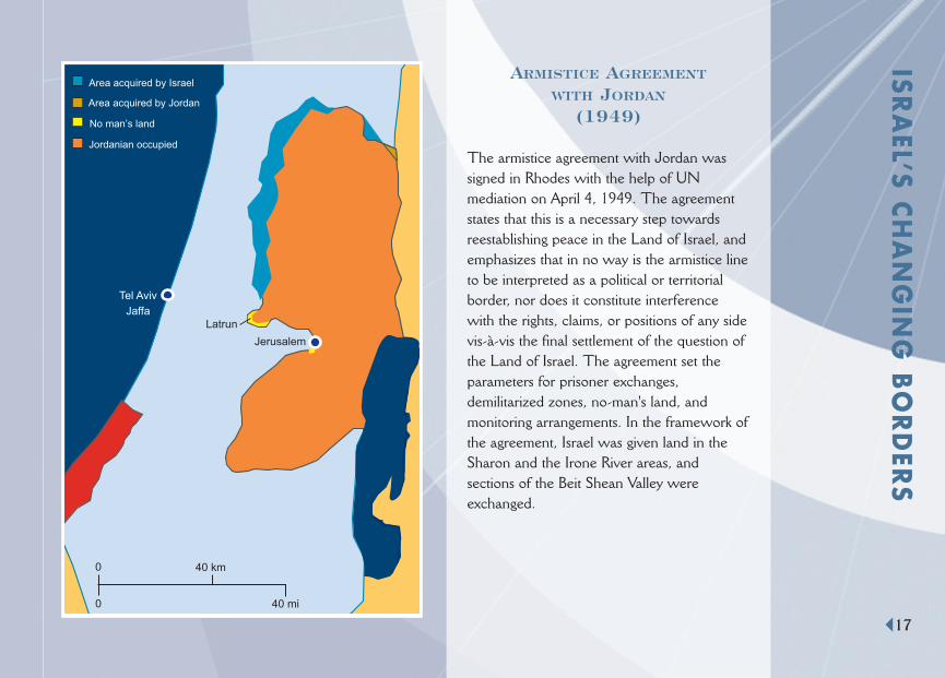
ARMISTICE AGREEMENT
WITH JORDAN
(1949)
The armistice agreement with Jordan wassigned in Rhodes with the help of UNmediation on April 4, 1949. The agreementstates that this is a necessary step towardsreestablishing peace in the Land of Israel, andemphasizes that in no way is the armistice lineto be interpreted as a political or territorialborder, nor does it constitute interferencewith the rights, claims, or positions of any sidevis-à-vis the final settlement of the question ofthe Land of Israel. The agreement set theparameters for prisoner exchanges,demilitarized zones, no-man's land, andmonitoring arrangements. In the framework ofthe agreement, Israel was given land in theSharon and the Irone River areas, andsections of the Beit Shean Valley wereexchanged.
Jerusalem
Tel Aviv
JaffaLatrun
0
0
40 km
40 mi
No man’s land
Jordanian occupied
Area acquired by Jordan
Area acquired by Israel
ISRA
EL’S CH
AN
GIN
G B
OR
DER
S
17
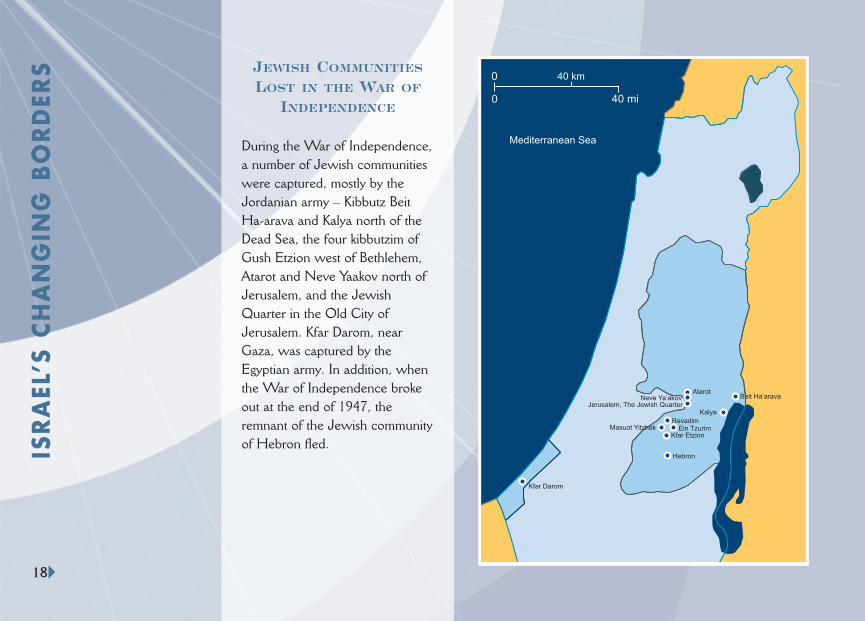
JEWISH COMMUNITIES
LOST IN THE WAR OF
INDEPENDENCE
During the War of Independence, a number of Jewish communitieswere captured, mostly by theJordanian army – Kibbutz Beit Ha-arava and Kalya north of theDead Sea, the four kibbutzim ofGush Etzion west of Bethlehem,Atarot and Neve Yaakov north ofJerusalem, and the JewishQuarter in the Old City ofJerusalem. Kfar Darom, nearGaza, was captured by theEgyptian army. In addition, whenthe War of Independence brokeout at the end of 1947, theremnant of the Jewish communityof Hebron fled.
Mediterranean Sea
Kfar Darom
Jerusalem, The Jewish Quarter
Hebron
Kfar EtzionEin TzurimMasuot Yitzhak
Revadim
Kalya
Beit Ha’aravaAtarot
Neve Ya’akov
00
00 40 mi
40 km
ISR
AEL
’S C
HA
NG
ING
BO
RD
ERS
18
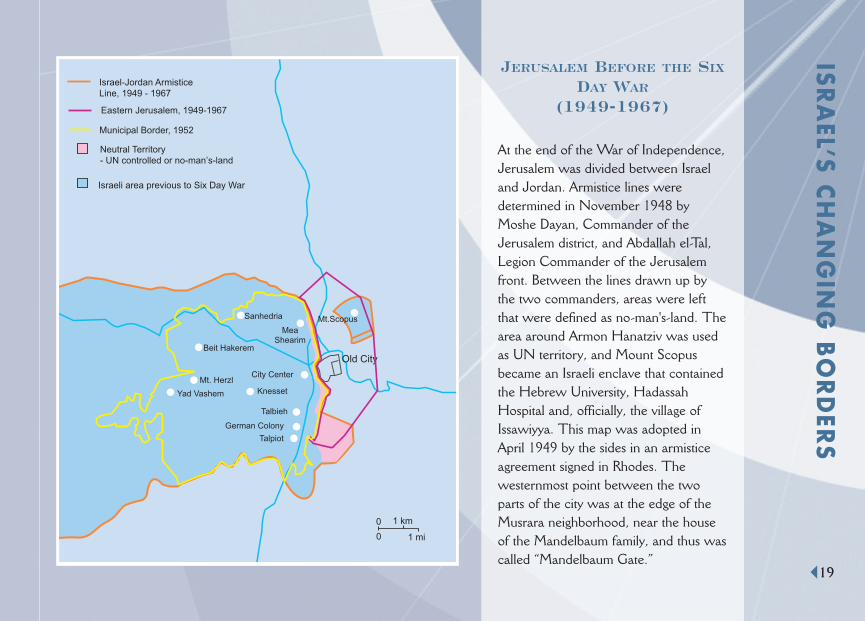
JERUSALEM BEFORE THE SIX
DAY WAR
(1949-1967)
At the end of the War of Independence,Jerusalem was divided between Israeland Jordan. Armistice lines weredetermined in November 1948 byMoshe Dayan, Commander of theJerusalem district, and Abdallah el-Tal,Legion Commander of the Jerusalemfront. Between the lines drawn up bythe two commanders, areas were leftthat were defined as no-man's-land. Thearea around Armon Hanatziv was usedas UN territory, and Mount Scopusbecame an Israeli enclave that containedthe Hebrew University, HadassahHospital and, officially, the village ofIssawiyya. This map was adopted inApril 1949 by the sides in an armisticeagreement signed in Rhodes. Thewesternmost point between the twoparts of the city was at the edge of theMusrara neighborhood, near the houseof the Mandelbaum family, and thus wascalled “Mandelbaum Gate.”
Israel-Jordan ArmisticeLine, 1949 - 1967
Old City
City Center
Talbieh
German Colony
Talpiot
Yad Vashem
Mt. Herzl
Beit Hakerem
Sanhedria
Knesset
Neutral Territory- UN controlled or no-man’s-land
Municipal Border, 1952
Eastern Jerusalem, 1949-1967
MeaShearim
Israeli area previous to Six Day War
Mt.Scopus
1 km
1 mi
0
0
ISRA
EL’S CH
AN
GIN
G B
OR
DER
S
19
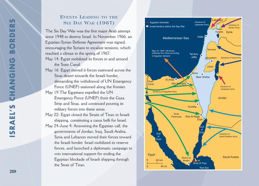
EVENTS LEADING TO THE
SIX DAY WAR (1967)
The Six Day War was the first major Arab attemptsince 1948 to destroy Israel. In November 1966, anEgyptian-Syrian Defense Agreement was signed,encouraging the Syrians to escalate tensions, whichreached a climax in the spring of 1967. May 14: Egypt mobilized its forces in and around
the Suez Canal. May 16: Egypt moved it forces eastward across the
Sinai desert towards the Israeli border,demanding the withdrawal of UN EmergencyForce (UNEF) stationed along the frontier.
May 19:The Egyptians expelled the UNEmergency Force (UNEF) from the GazaStrip and Sinai, and continued pouring itsmilitary forces into these areas.
May 22: Egypt closed the Straits of Tiran to Israelishipping, constituting a casus belli for Israel.
May 24-June 4: Answering the Egyptian call, thegovernments of Jordan, Iraq, Saudi Arabia,Syria and Lebanon moved their forces towardthe Israeli border. Israel mobilized its reserveforces, and launched a diplomatic campaign towin international support for ending theEgyptian blockade of Israeli shipping throughthe Strait of Tiran.
Mediterranean Sea
Beer Sheba
Tel AvivJaffa
Haifa
Jerusalem
Syria
Jordan
Saudi Arabia
Red Sea
SinaiPeninsula
Egypt
SuezCanal
Eilat
Samaria
Judea
GolanHeights
Gulfof
Suez
Gulfof
Eilat
Israeli territory before Six Day War
Gaza
0 40 km
40 mi0
Strait of Tiran
Egyptian blockade
May 19, 1967: UN forceswithdraw from Sinai according
to Egyptian demand.
Sharm elSheikh
Advance of
Syrian Army
Advance of Iraqi Army
Advance of Egyptian Army
Advance of
Saudi Arabian Army
Advance of
Jordanian Army
LebanonAdvance of
Lebanese Army
Abu Aweigila
El Arish
Kuntilla
Ras Al-Nagb
ISR
AEL
’S C
HA
NG
ING
BO
RD
ERS
20
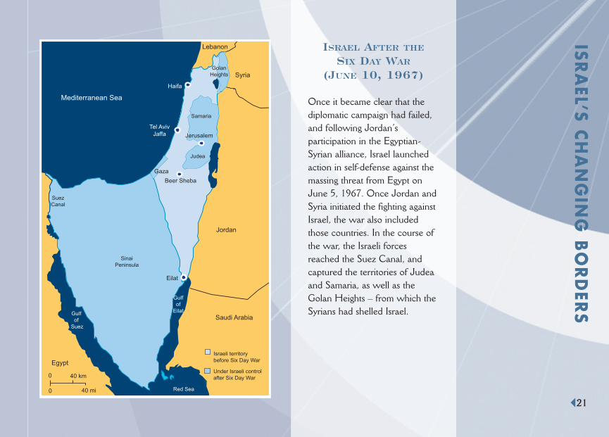
ISRAEL AFTER THE
SIX DAY WAR
(JUNE 10, 1967)
Once it became clear that thediplomatic campaign had failed,and following Jordan’sparticipation in the Egyptian-Syrian alliance, Israel launchedaction in self-defense against themassing threat from Egypt onJune 5, 1967. Once Jordan andSyria initiated the fighting againstIsrael, the war also includedthose countries. In the course ofthe war, the Israeli forcesreached the Suez Canal, andcaptured the territories of Judeaand Samaria, as well as theGolan Heights – from which theSyrians had shelled Israel.
Mediterranean Sea
Beer Sheba
Tel AvivJaffa
Haifa
Jerusalem
Lebanon
Syria
Jordan
Saudi Arabia
Red Sea
SinaiPeninsula
Egypt
SuezCanal
Eilat
Samaria
Judea
GolanHeights
Gulfof
Suez
Gulfof
Eilat
Israeli territorybefore Six Day War
Under Israeli controlafter Six Day War
Gaza
0 40 km
40 mi0
ISRA
EL’S CH
AN
GIN
G B
OR
DER
S
21

NeveYaakov
RamatEshkol
Ramot
EastTalpiot
Gilo
Israel-Jordan ArmisticeLine, 1949 - 1967
Jerusalem MunicipalBoundary after Six Day War
Major Jewish suburbs sinceSix Day War
Old City
JewishQuarter
City Center
Talbieh
German Colony
Talpiot
Yad Vashem
Mt. Herzl
Beit Hakerem
Sanhedria
Knesset
MeaShearim
Mt.Scopus
FrenchHill
HarHoma
Malcha
PisgatZeev
Har Nof
00 1 km
1 m00
Dome ofthe Rock
Al-AksaMosque
TempleMount
Damascus Gate
Jaffa Gate
Dung Gate
Zion Gate
Mount Zion
City of David
Golden Gate
Lion’s Gate
Herod’sGate
Dome ofthe Rock
Al-AMos
TempleMount
Herod’sGate
Al-AksaMosque
Dung Gat
City of Da
Damascus Gate
MoslemQuarter
JewishQuarter
ChristianQuarter
WesternWall
Church ofthe HolySepulchre
NewGate
0
0
.5 km
.5 m
Cardo
Zion Gate
ArmenianQuarter
Citadel
Tower of David
Mt. ofOlives
ISR
AEL
’S C
HA
NG
ING
BO
RD
ERS JERUSALEM AFTER THE SIX DAY WAR
(1967)OLD CITY OF JERUSALEM
22
A few days after the end of theSix Day War, on June 27, 1967,the Israeli Parliament passed alaw that Israeli administrationand jurisdiction apply to all theterritory of Jerusalem acquiredin the war. The following day,the Jerusalem municipalboundaries were extended toinclude eastern Jerusalem, aswell as Atarot and Neve Yaakovin the north, and Gilo in thesouth.
ISRA
EL’S CH
AN
GIN
G B
OR
DER
S
23
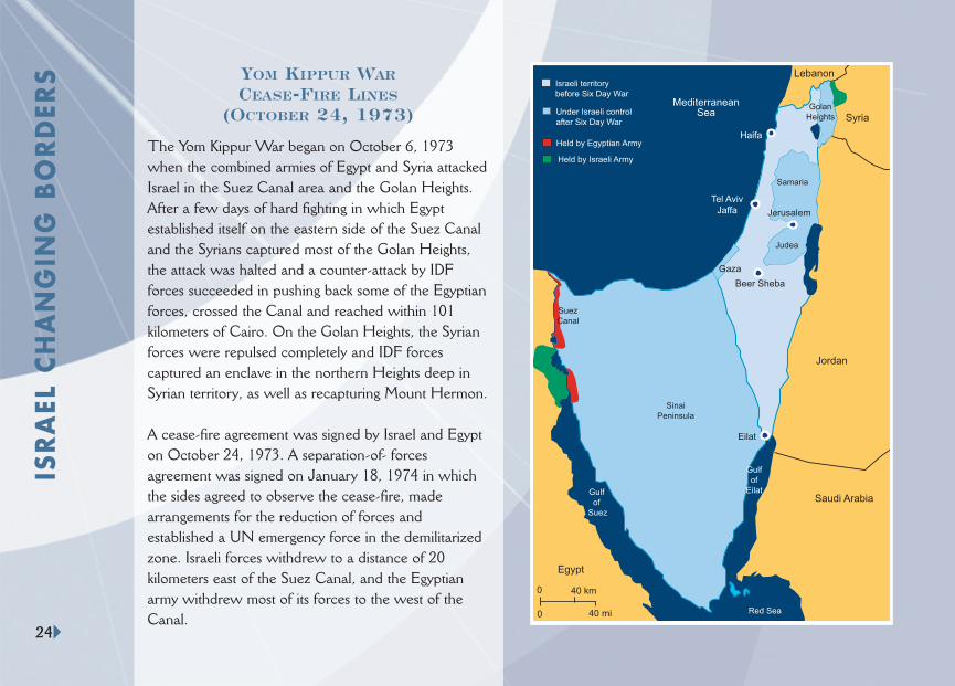
YOM KIPPUR WARCEASE-FIRE LINES
(OCTOBER 24, 1973)
The Yom Kippur War began on October 6, 1973when the combined armies of Egypt and Syria attackedIsrael in the Suez Canal area and the Golan Heights.After a few days of hard fighting in which Egyptestablished itself on the eastern side of the Suez Canaland the Syrians captured most of the Golan Heights,the attack was halted and a counter-attack by IDFforces succeeded in pushing back some of the Egyptianforces, crossed the Canal and reached within 101kilometers of Cairo. On the Golan Heights, the Syrianforces were repulsed completely and IDF forcescaptured an enclave in the northern Heights deep inSyrian territory, as well as recapturing Mount Hermon.
A cease-fire agreement was signed by Israel and Egypton October 24, 1973. A separation-of- forcesagreement was signed on January 18, 1974 in whichthe sides agreed to observe the cease-fire, madearrangements for the reduction of forces andestablished a UN emergency force in the demilitarizedzone. Israeli forces withdrew to a distance of 20kilometers east of the Suez Canal, and the Egyptianarmy withdrew most of its forces to the west of theCanal.
MediterraneanSea
Beer Sheba
Tel AvivJaffa
Haifa
Jerusalem
Lebanon
Syria
Jordan
Saudi Arabia
Red Sea
SinaiPeninsula
Egypt
Eilat
Samaria
Judea
Gulfof
Suez
Gulfof
Eilat
Under Israeli controlafter Six Day War
Gaza
GolanHeights
Held by Egyptian Army
Held by Israeli Army
Israeli territorybefore Six Day War
SuezCanal
0 40 km
40 mi0
ISR
AEL
CH
AN
GIN
G B
OR
DER
S
24

U.N. patrolled demilitarized zone
Previous forward line of IsraelDefense Forces
Rafid
Jubbata
Khan Erenbe
Jeba
Towns returned to Syria
Kafr Shams
Banyas
Safed
Tiberias
Sea ofGalilee
Kuneitra
Damascus
Under Israeli control after Six Day War
Mazraat Beit Jann
Syria
Lebanon
MediterraneanSea
Jordan
0 10 km
0 10 mi
Mt.Hermon
A disengagementagreement with Syriawas signed in Genevaon May 31, 1974, andincluded, inter alia, theestablishment of UNobservers in thedemilitarized zone,arrangements for aprisoner exchange, andIDF evacuation of theterritory it took in theYom Kippur War, aswell as the city ofKuneitra, which wascaptured in the Six DayWar.
Kafr Shams
Banyas
Syria
Lebanon
Jordan
MazraatBeit Jann
Sea ofGalilee
Safed
Tiberias
MediterraneanSea
Damascus
Kuneitra
0 10 km
0 10 mi
Held by Israel Defense Forcesafter Yom Kippur War
Under Israeli control afterSix Day War
Israeli - Syrian border as agreedon in 1923
Mt.Hermon
ISRA
EL’S CH
AN
GIN
G B
OR
DER
S
25
GOLAN HEIGHTS
CEASE-FIRE LINES
(OCTOBER 1973)
ISRAEL-SYRIA
DISENGAGEMENT AGREEMENT
(MAY 1974)

ISR
AEL
’S C
HA
NG
ING
BO
RD
ERS An agreement was signed in Geneva in
September 1975 in addition to the 1974separation-of-forces agreement followingthe Yom Kippur War. The main points ofthe agreement were: Israeli withdrawal inSinai to the eastern ends of the Mitla andGidi Passes; creation of a UN-monitoredbuffer zone in the evacuated area; turningthe previous buffer zone into Egyptianterritory; Israeli withdrawal from the oilfields at Abu Rudeis and Ras Sudar. It wasalso agreed to open the Suez Canal toIsraeli non-military cargo ships and toestablish American early-warning stations inthe area of the passes. The agreement wasperceived as an important step towards ajust and sustainable peace.
The Israel-Egypt Peace Treaty was signedon March 26,1979, following the CampDavid Accords of September 18,1978,which determined a framework for a peacetreaty between both countries.Theframework also set a timetable forestablishing diplomatic relations andnormalization between Israel and Egypt,aswell as a timetable for IDF withdrawal fromthe line beginning east of El-Arish andextending to Ras Mohamed. The peacetreaty tied up loose threads and includedfurther Israeli withdrawal to theinternational border between the two states.
INTERIM AGREEMENT
WITH EGYPT
(1975)
PEACE TREATY WITH EGYPT
AND SINAI REDEPLOYMENT
(1980 – 1982)
26

ISRAEL’S DISENGAGEMENT PLAN (2005)
NORTHERN SAMARIA
Area A: Full Palestinian Control
Area C: Former Israeli Control
Former Israeli Community
Palestinian Community
Pre-1967 cease-fire-lines
GAZA STRIP
ISRA
EL’S CH
AN
GIN
G B
OR
DER
S
27
In August 2005, Israel disengaged from the Gaza Strip, and from foursettlements in northern Samaria. This action, initiated by PrimeMinister Sharon and endorsed by the Knesset, was an Israeli initiativedesigned to end the stalemate in the peace process after more thanfour years of terrorist bloodshed. Altogether 25 settlements wereremoved. This entailed a considerable sacrifice on the part of thenearly 9000 residents who had to leave their homes and livelihoodsthat they had built over the course of several decades. It alsodemonstrated Israel’s readiness to make major concessions for thesake of peace.
Following disengagement, the Gaza Strip is under Palestinianjurisdiction. This constitutes a practical test of the PalestinianAuthority’s intentions regarding peaceful coexistence. It couldcontribute to the renewal of peace talks and to the establishment of aPalestinian state alongside Israel as envisaged by the Roadmap,provided the Palestinians fulfill their obligations to end terrorism andincitement. However, the Hamas election victory in January 2006undermines this possibility.
MO
DER
N D
AY
ISR
AEL
28
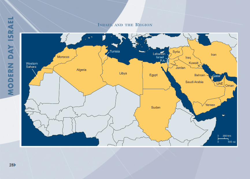
ISRAEL AND THE REGION
MO
DER
N D
AY
ISRA
EL
29
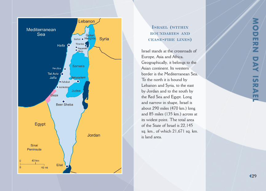
ISRAEL (WITHIN
BOUNDARIES AND
CEASE-FIRE LINES)
Israel stands at the crossroads ofEurope, Asia and Africa.Geographically, it belongs to theAsian continent. Its westernborder is the Mediterranean Sea.To the north it is bound byLebanon and Syria, to the eastby Jordan and to the south bythe Red Sea and Egypt. Longand narrow in shape, Israel isabout 290 miles (470 km.) longand 85 miles (135 km.) across atits widest point. The total areaof the State of Israel is 22,145sq. km., of which 21,671 sq. km.is land area.
MO
DER
N D
AY
ISR
AEL
30
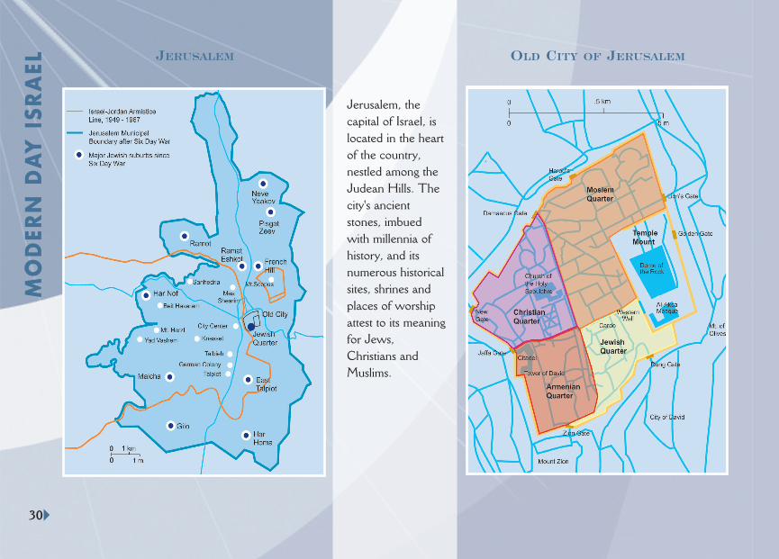
JERUSALEM OLD CITY OF JERUSALEM
Jerusalem, thecapital of Israel, islocated in the heartof the country,nestled among theJudean Hills. Thecity's ancientstones, imbuedwith millennia ofhistory, and itsnumerous historicalsites, shrines andplaces of worshipattest to its meaningfor Jews,Christians andMuslims.