iso 19152 the land administration domain model uganda … · iso 19152 – the land administration...
TRANSCRIPT
1
ISO 19152 – THE LAND ADMINISTRATION DOMAIN MODEL
1,3Christiaan Lemmen, 2Prof Dr Peter van Oosterom
1 Faculty of Earth Observation and Geo-Information Science (ITC), University of Twente, P.O. Box 217, 7500 AE Enschede, THE NETHERLANDS.
2 Delft University of Technology, OTB, Section GIS Technology,
P.O. Box 5030, 2600 GA Delft, THE NETHERLANDS.
3 Netherlands Cadastre, Land Registry and Mapping Agency, Kadaster International P.O. Box 9046, 7300 GH Apeldoorn, THE NETHERLANDS
email: [email protected] , [email protected] , [email protected]
Abstract
Focus of this paper is on the Land Administration Domain Model which is under development as an International Standard at ISO. This development is an initiative of the International Federation of Surveyors – FIG. The International Standard is expected to be published in 2012. Why is this development important? What is the scope of the standard, what is included and what is not included? There will be a brief overview of the contents of the standard with attention to its core packages and to the relation to other standards (such as data quality aspects and surveying). The idea is that not only the field-survey based, high accurate, cadastral maps are supported by this standard. This would otherwise mean that many approaches would be excluded and the world is absolutely not waiting for that. On the contrary, many high accurate approaches are slow and expensive and proven not to work. A specialization of the standard, the so called “Social Tenure Domain Model (STDM)” will be introduced. This is a flexible approach to pro poor land administration on a participatory basis. The flexibility is in the unconventional options for descriptions of spatial units, parties and relations between spatial units and parties. This means informal and customary relations between people and land can be included: land administration for everyone in a local environment – not necessarily linked to formal systems but with options for future integration. Keywords: LADM, STDM, Standardisation, Cadastre, Land Administration, Social Tenure
1 INTRODUCTION Land administration is an instrument for implementation of land policies. In a land administration systems people to land relationships are described. This implies that existing right holders can be integrated in the process of implementation of policies; e.g. by recognition and description of their rights, by re-allocation of their existing land rights (based on participatory approaches in land consolidation, land reforms), by compensation measures, etc. Recognition of existing land rights can be a policy in itself. In can be a very efficient instrument to avoid disputes and to avoid overlapping claims. For example if big agricultural plots are sold to companies abroad it may be wise to map the existing situation where land rights are concerned.
2
Also in case of implementation of spatial plans (related to urban planning, rural development, development of infrastructure, etc) it is important to know the existing situation on land use rights. Land use rights can be communual land rights, customary rights, informal rights or formal ownership rights, etc. This means land administration can be used to describe and monitor different situations in time for one area: the existing situation before change1, and the implemented situation afterwards; and all changes in between. In support of this a Land Administration System (LAS) is needed. Williamson et al (2010) define a Land Administration System as an infrastructure for implementation of land policies and land management strategies in support of sustainable development. The infrastructure includes institutional arrangements, a legal framework, processes, standards, land information, management and dissemination systems, and technologies required to support allocation, land markets, valuation, control of use, and developments of interests in land. The Land Administration Domain Model (LADM) has been published as a Draft International Standard by the International Organization for Standardization (ISO, 2011), as ISO 19152. The last comments provided by the participating members of the ISO Technical Committee 211 are under process now (October 2011). A Final Draft International Standard will be published at November 7th 2011 for voting by the participating members. If the voting is positive the LADM will be published in 2012. This paper first explains the need and importance of the standardisation of the land administration domain in section 2. The scope of standardisation is explained in section 3. This is followed in section 4 by a brief explanation of the contents of the Draft International Standard, see ISO, 2011. Maps with representations of spatial to land relationships are discussed in section 5. A specialization of the LADM standard which is developed for customary and informal tenure systems is presented in section 6: the Social Tenure Domain Model (STDM). Collection of spatial data where those relationships apply is discussed in section 7. The paper ends with conclusions as in section 8. 2 WHY IS THIS STANDARDISATION DEVEPMENT IMPORTANT? In many countries the existing the land administration systems are incomplete, the existing data are not up to date, the data sets are not easy to access (distributed over many organisations and data are inconsistent), the focus is too much on the spatial component and insufficient on the social, legal, economic and environmental issues, the is insufficient attention for the rights of the poor. There is a need for attention to spatio-temporal aspects (e.g. pastoralists crossing spatial units at begin and end of dry season). Carbon credits, mining concessions, water rights, etc could be better integrated, this can be extended with many other Rights, Restrictions and Responsibilities. Land administration can be a crucial element in support to disaster management. There is a need for pro poor LAS. LASs should include forest, wetland, customary, informal settlement, and should support large scale identification of land rights and claims following natural disaster, post conflict, overlapping claims. ‘Light’ solutions are needed to built a LAS that really reflects the situation on the ground, transparency is a key issue. See also Clarissa Augustinus, Keith Bell, Paul van der Molen and others in a spatial issue of GIM International, (2011). From experience it is known many countries have problems in designing and developing LASs. A standardised domain standard is required: this is the Land Administration Domain
1 ‘Change’ should be read here as land reform, consolidation, readjustment, re-parcellation or re-allotment. This spatial planning is a domain in it self, but land administration is in support here to keep the overview of the implementation process.
3
Model. The implementation of such a standard makes the development of LAS more easy. It can be adopted to local situations. Implementation of parts of datasets at central and parts of data sets at de-central level should be possible, data exchange between involved organisations should be easy, aggregation of data to a national or regional level should be possible, data duplications should be avoidable, it should be easy to reconstruct historical data etc. Core of a Land Administration System is its data. Data on parties (natural or non natural persons) an spatial units and on the relationships between parties and spatial units: the land (use) rights. Those data can be available in one or more organisations; in a central or de-central environment; in rural and urban environment and can concern state lands (natural resources). There can be different types of tenures to be represented in a LAS. It is important that all those differences have no impact on the organisation of the data. If there would be (for example) differences between the structures of data sets in rural and an urban LAS there could be serious complications in the support of urban expansion by urban planning in a controlled way. Those complications concern conversion and consistency problems; the existing data have to be converted from one LAS to another and have to remain up to date during this process. The standardized Land Administration Domain Model (LADM), covers land registration and cadastre in a broad sense (spatial and administrative components, source documentation included), and will serve the following goals: 1. avoid reinventing and re-implementing the same functionality over and over again, but
provide a extensible basis for efficient and effective cadastral system development based on a model driven architecture,
2. enable involved parties, both within one administrative region in a country and between different administrative regions, to communicate based on the shared ontology implied by the model and
3. facilitate cadastre data exchange between in country organizations (ex: National Agency and Municipalities) and between countries or states within a country.
Such Land Administration Domain Model (ISO, 2011; Van Oosterom et al, 2006; Lemmen et al 2010a, 2010b) underpins existing conventional land administration systems. These conventional systems take into account conventional legal forms of evidence and are in principle parcel based. This means that they only cover a portion of all forms of land tenure. Also they cannot accommodate all forms of tenures. Globally there are many examples where the land use rights of informal settlement residents, slum dwellers, families and groups living under customary tenure, indigenous people, pastoralists, refugees etc. are not capable of being integrated into a conventional land administration system. The Social Tenure Domain Model (STDM) has been designed to cover all types of tenures, conventional and other social tenures such as informal and customary tenures (Augustinus et al, 2006). It compliments the Land Administration Domain Model (LADM) and allows inter-operability between the two systems (Augustinus and Lemmen, 2011). 3 WHAT IS THE SCOPE OF THE STANDARD? The draft standard for the Land Administration Domain defines a reference Model (LADM) covering basic information-related components of Land Administration (including those over water as well as land, and elements above and below the surface of the earth). It provides an abstract conceptual schema and a terminology for land administration, based on various national and international systems, that is as simple as possible in order to be useful in practice. The terminology allows a shared description of different formal or informal practices and procedures in various jurisdictions. It enables the combining of land administration information from different sources in a coherent manner.
4
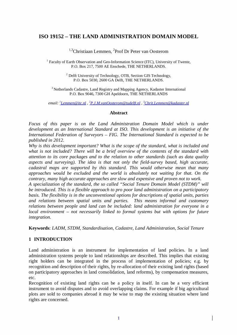
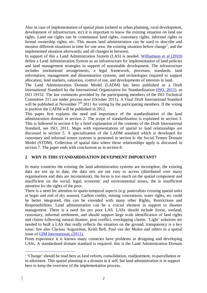
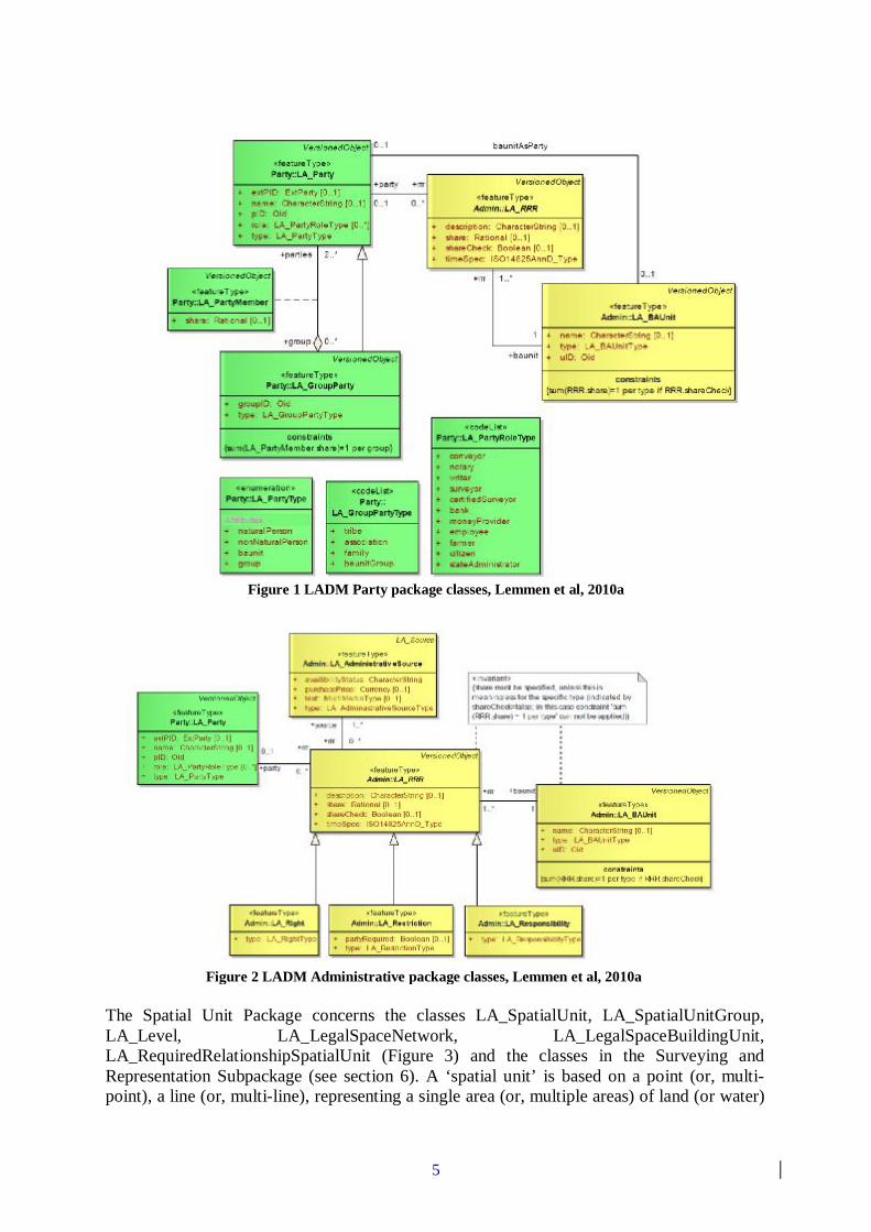
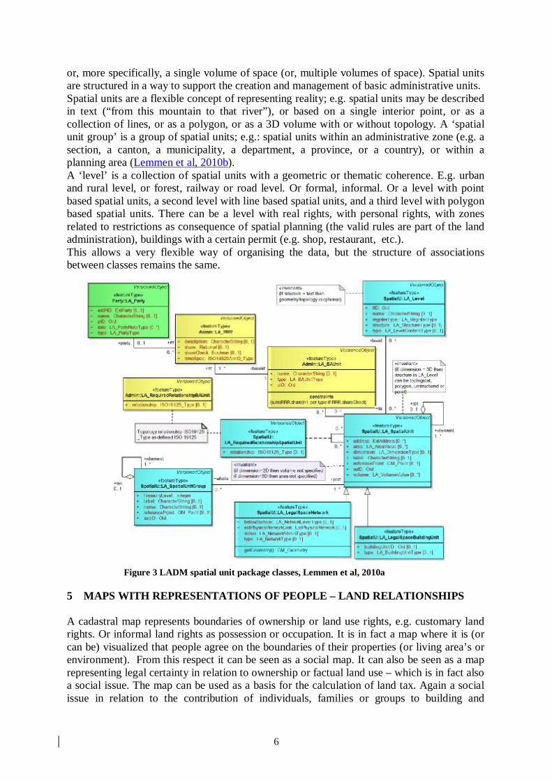
It includes agreements on data about administrative and spatial units, land rights in a broad sense and source documents (e.g. declarations, adjudication documents, provided descriptions and drawings, titles, deeds or survey documentation). The rights may include real and personal rights as well as customary and informal rights; the latter can be included as ‘social tenure relations’ in the STDM. Restrictions and responsibilities can be similarly represented in a flexible way to document the relationships between people and land. Surveys can be based on aerial or satellite imagery. LADM describes the data contents of land administration in general, based on a practical approach. The roots are, amongst others, in FIGs Cadastre 2014 (Kaufmann, J. and D. Steudler, 1998), in Fourie, 1998, and in Henssen, 1995. LADM implementation can be performed in a flexible way; the standard can be extended and adapted to local situations. External links to other data bases, e.g. addresses, are included. The draft standard defines the core issues in land administration. The LADM is a conceptual schema organised in packages: (1) Party Package, (2) Administrative Package and (3) Spatial Unit Package (including the Surveying and Representation Subpackage). In section 4 the contents of those packages are presented in further detail. Existing standards have been re-used, particularly the ISO 19100 series from ISO/TC 211. LADM can be a basis for combining data from different Land Administration Systems. The Draft International Standard includes informative example cases with people and land relationships demonstrating the flexibility of the draft standard. 4 CONTENTS OF THE LAND ADMINISTRATION DOMAIN MODEL The three main packages of the LADM, the Party Package, the Administrative Package, and the Spatial Unit Package are presented in this section. The main class of the Party Package is the class LA_Party, and its specialization LA_GroupParty. There is an optional association class LA_PartyMember (Figure 1). Parties are persons, or groups of persons, or juridical persons, that compose an identifiable single (legal) entity. A juridical person may be a company, a municipality, the state, or a religious community. A ‘group party’ is any number of parties, forming together a distinct entity; e.g. a tribe or a co-operation. A ‘party member’ is a constituent of a party or group party. The Administrative Package concerns the abstract class LA_RRR (with its three concrete subclasses LA_Right, LA_Restriction, and LA_Responsibility), and class LA_BAUnit (an abbreviation for ‘basic administrative unit’), see Figure 2. A ‘right’ is a formal or informal entitlement to own, to do something, or to refrain from doing something. Examples are: ownership right, tenancy right, possession, customary right, or informal right. A right can be an (informal) use right. Rights may be overlapping, or may be in disagreement. A ‘restriction’ is a formal or informal entitlement to refrain from doing something; e.g. it is not allowed to build within 50 meters from a road. A ‘responsibility’ is a formal or informal obligation to do something; e.g. the responsibility to clean a water canal or to maintain a road. A ‘baunit’ is an administrative entity consisting of zero or more spatial units against which one or more rights (e.g. an ownership right or a land use right), responsibilities or restrictions are associated, as included in a land administration system (LA system). An example of a ‘baunit’ is a basic property unit with two spatial units (e.g. an apartment and a garage). Or with three spatial units: a village, a hunting area and a remote fishing area. It should be observed in relation to this that certain types of rights, restrictions, and responsibilities may affect only a part of the spatial unit, with the geometric representation of that part missing.
5
Figure 1 LADM Party package classes, Lemmen et al, 2010a
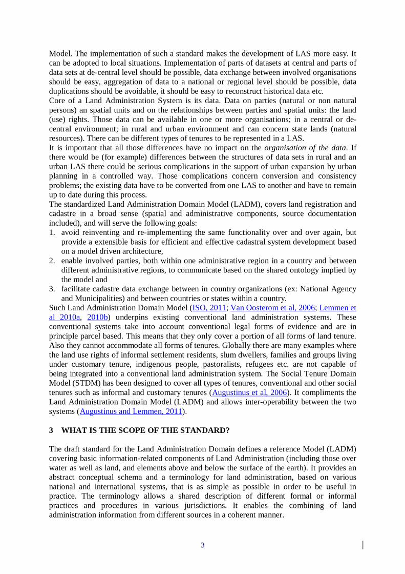
The Spatial Unit Package concerns the classes LA_SpatialUnit, LA_SpatialUnitGroup, LA_Level, LA_LegalSpaceNetwork, LA_LegalSpaceBuildingUnit, LA_RequiredRelationshipSpatialUnit (Figure 3) and the classes in the Surveying and Representation Subpackage (see section 6). A ‘spatial unit’ is based on a point (or, multi-point), a line (or, multi-line), representing a single area (or, multiple areas) of land (or water)
Figure 2 LADM Administrative package classes, Lemmen et al, 2010a
6
or, more specifically, a single volume of space (or, multiple volumes of space). Spatial units are structured in a way to support the creation and management of basic administrative units. Spatial units are a flexible concept of representing reality; e.g. spatial units may be described in text (“from this mountain to that river”), or based on a single interior point, or as a collection of lines, or as a polygon, or as a 3D volume with or without topology. A ‘spatial unit group’ is a group of spatial units; e.g.: spatial units within an administrative zone (e.g. a section, a canton, a municipality, a department, a province, or a country), or within a planning area (Lemmen et al, 2010b). A ‘level’ is a collection of spatial units with a geometric or thematic coherence. E.g. urban and rural level, or forest, railway or road level. Or formal, informal. Or a level with point based spatial units, a second level with line based spatial units, and a third level with polygon based spatial units. There can be a level with real rights, with personal rights, with zones related to restrictions as consequence of spatial planning (the valid rules are part of the land administration), buildings with a certain permit (e.g. shop, restaurant, etc.). This allows a very flexible way of organising the data, but the structure of associations between classes remains the same.
5 MAPS WITH REPRESENTATIONS OF PEOPLE – LAND RELATIONSHIPS A cadastral map represents boundaries of ownership or land use rights, e.g. customary land rights. Or informal land rights as possession or occupation. It is in fact a map where it is (or can be) visualized that people agree on the boundaries of their properties (or living area’s or environment). From this respect it can be seen as a social map. It can also be seen as a map representing legal certainty in relation to ownership or factual land use – which is in fact also a social issue. The map can be used as a basis for the calculation of land tax. Again a social issue in relation to the contribution of individuals, families or groups to building and
Figure 3 LADM spatial unit package classes, Lemmen et al, 2010a
7
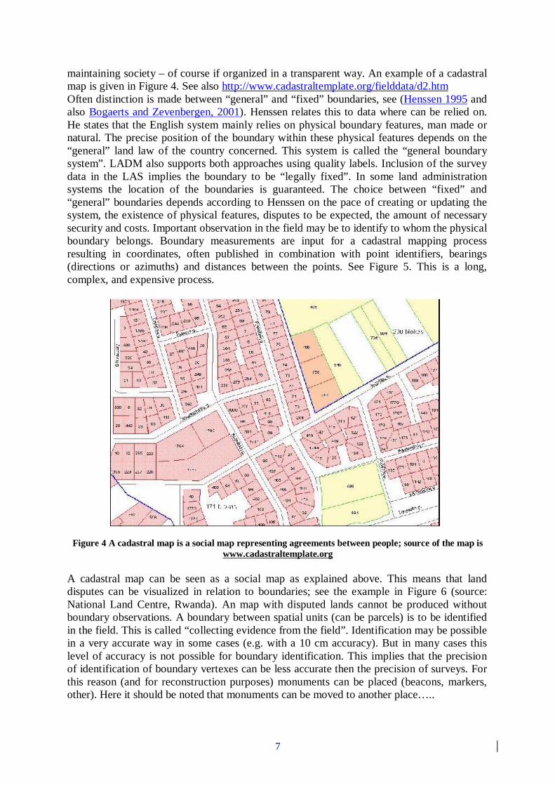
maintaining society – of course if organized in a transparent way. An example of a cadastral map is given in Figure 4. See also http://www.cadastraltemplate.org/fielddata/d2.htm Often distinction is made between “general” and “fixed” boundaries, see (Henssen 1995 and also Bogaerts and Zevenbergen, 2001). Henssen relates this to data where can be relied on. He states that the English system mainly relies on physical boundary features, man made or natural. The precise position of the boundary within these physical features depends on the “general” land law of the country concerned. This system is called the “general boundary system”. LADM also supports both approaches using quality labels. Inclusion of the survey data in the LAS implies the boundary to be “legally fixed”. In some land administration systems the location of the boundaries is guaranteed. The choice between “fixed” and “general” boundaries depends according to Henssen on the pace of creating or updating the system, the existence of physical features, disputes to be expected, the amount of necessary security and costs. Important observation in the field may be to identify to whom the physical boundary belongs. Boundary measurements are input for a cadastral mapping process resulting in coordinates, often published in combination with point identifiers, bearings (directions or azimuths) and distances between the points. See Figure 5. This is a long, complex, and expensive process.
Figure 4 A cadastral map is a social map representing agreements between people; source of the map is www.cadastraltemplate.org
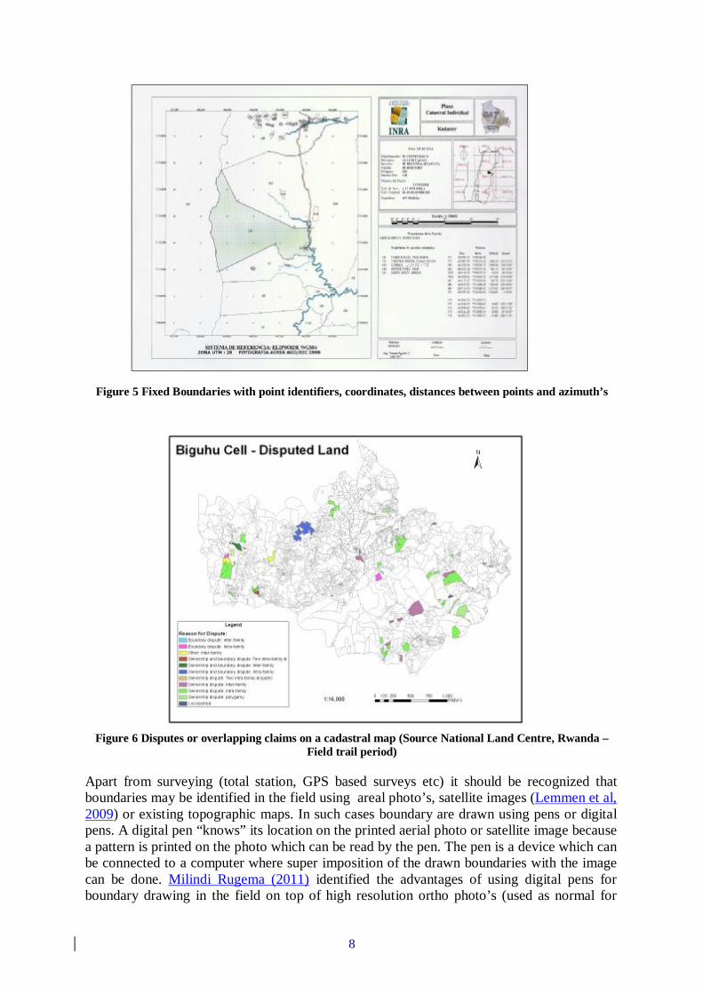
A cadastral map can be seen as a social map as explained above. This means that land disputes can be visualized in relation to boundaries; see the example in Figure 6 (source: National Land Centre, Rwanda). An map with disputed lands cannot be produced without boundary observations. A boundary between spatial units (can be parcels) is to be identified in the field. This is called “collecting evidence from the field”. Identification may be possible in a very accurate way in some cases (e.g. with a 10 cm accuracy). But in many cases this level of accuracy is not possible for boundary identification. This implies that the precision of identification of boundary vertexes can be less accurate then the precision of surveys. For this reason (and for reconstruction purposes) monuments can be placed (beacons, markers, other). Here it should be noted that monuments can be moved to another place…..
8
Figure 5 Fixed Boundaries with point identifiers, coordinates, distances between points and azimuth’s
Figure 6 Disputes or overlapping claims on a cadastral map (Source National Land Centre, Rwanda –
Field trail period) Apart from surveying (total station, GPS based surveys etc) it should be recognized that boundaries may be identified in the field using areal photo’s, satellite images (Lemmen et al, 2009) or existing topographic maps. In such cases boundary are drawn using pens or digital pens. A digital pen “knows” its location on the printed aerial photo or satellite image because a pattern is printed on the photo which can be read by the pen. The pen is a device which can be connected to a computer where super imposition of the drawn boundaries with the image can be done. Milindi Rugema (2011) identified the advantages of using digital pens for boundary drawing in the field on top of high resolution ortho photo’s (used as normal for
9
drawing boundaries in Rwanda): easy for local people in Participatory-Mapping; boundaries direct geo-referenced on site; digital pen predictable for climate conditions; rechargeable after long time used and no loss of data when battery is discharged. Examples of other data acquisition tools are mobile mapping tools, see for example Lemmens (2010). Most relevant for LADM is not the different approaches in data acquisition but the options to include the results of data acquisitions (and processing of those data). In LADM it is important that the original field observations can be kept. 6 THE SOCIAL TENURE DOMAIN MODEL STDM is basically about people-land relationships and is intended to broaden the traditional scope of land administration by providing a land information management framework that would integrate formal, informal, and customary land systems, as well as integrate administrative and spatial components. The STDM makes this possible through tools that facilitate recording all forms of land rights, all types of rights holders and all kinds of land and property objects/spatial units regardless of the level of formality. The thinking behind the STDM also goes beyond some established conventions. Traditional or conventional land administration systems, for example, relate names or addresses of persons to land parcels via rights. An alternative option is being provided by the STDM, which instead relates personal identifiers, such as fingerprints, to a coordinate point inside a plot of land through a social tenure relation such as tenancy. The STDM thus provides an extensible basis for an efficient and effective system of land rights recording. This extensible basis means (Augustinus and Lemmen, 2011): - inclusion of the representation of all people-land relationships – the continuum of land
rights (UN-HABITAT, 2008) applied in global setting. New types of relations to be easily included. The STDM describes relationships between people and land in an unconventional manner, tackling land administration needs in hitherto neglected communities, such as people in informal settlements and customary areas. It supports the development and maintenance of records in areas where regular or formal registration of land rights is not the rule. It focuses on land and property rights which are neither registered nor registerable, as well as overlapping claims that may have to be adjudicated in terms of "who", "where" and "what right". In other words, the emphasis is on social tenure relationships as embedded in the continuum of the land rights concept promoted by Global Land Tool Network and by UN-HABITAT (2008). In the 2003 FIG workshop in Enschede (FIG, 2003) there was a lot of attention to the inclusion of ‘informal area’s’ into Cadastral Data Models. In the 2004 FIG workshop in Bamberg ‘Formal Ownership’; ‘Customary Tenure’; ‘Indigenous Tenancy’; ‘Starter, land hold, free hold Evolution’; ‘Possession’; ‘Mortgage, Usufruct, Long Lease, many Restriction Types’; ‘State Lands’; ‘Informal and Unknown people- land Relationships’; ‘Disagreement’; ‘Occupation’; ‘Uncontrolled privatization (which is in fact a kind of transaction) and ‘Conflict’ were presented as a set of (extensible) relations between people and land (Van Oosterom et al, 2004). A first start in this approach with extensible code tables was presented in a paper to the FIG working week in Paris, France (Lemmen, et al, 2003a and Lemmen et al 2003b). In the LADM a range of spatial units was introduced based on the review of Fourie 1998.
- a range of people and social structures, this means a range of types of parties can be included, without exceptions. Parties are persons, or groups of persons, or non natural persons, that compose an identifiable single entity. A non natural person may be a tribe, a family, a village, a company, a municipality, the state, a farmers´ cooperation, or a church
10
community. This list may be extended, and it can be adapted to local situations, based on community needs. See also Lemmen, 2010c
- a range of units of land-use rights. Land rights may be formal ownership, apartment right, usufruct, free hold, lease hold, or state land. It can also be social tenure relationships like occupation, tenancy, nonformal and informal rights, customary rights (which can be of many different types with specific names), indigenous rights, and possession. There may be overlapping claims, disagreement and conflict situations. There may be uncontrolled privatisation. Again, this is an extensible list to be filled in with local tenancies. A restriction is a formal or informal entitlement to refrain from doing something; e.g. it is not allowed to have ownership in indigenous areas. Or it may be a servitude or mortgage as a restriction to the ownership right. There may be a temporal dimension, e.g. in case of nomadic behaviour when pastoralist cross the land depending on the season. This temporal dimension has sometimes a fuzzy nature, e.g. ”just after the end of the rainy season”. See also Lemmen, 2010c
- a range of spatial units. Augustinus et al (2006) provides a comprehensive overview. See also Lemmen, 2010c. Spatial units are the areas of land (or water) where the rights and social tenure relationships apply. According to the LADM/STDM ISO-standard those areas can be represented as a text (“from this tree to that river”), as a single point, as a set of unstructured lines, as a surface, or even as a 3D volume. This range of spatial unit representation can cover community based land administration systems, or rural, or urban, or other types of land administrations, like marine cadastres and 3D cadastres. Surveys may concern the identification of spatial units on a photograph, an image or a topographic map. There may be sketch maps drawn up locally. A sketch map may be drawn on a wall where a photograph is taken from.
- a range of different field data acquisition methods can be applied resulting in (a range of types of) (authentic) source documentation for spatial and non spatial data. Unconventional and participatory approaches in collecting evidence from the field; participation could mean the presentation fo field collected data in the evening to the community. Different data acquisition methods mean different data qualities; quality attributes can be included. E.g. Dr Zerfu Hailu and Lennart Backstrom (2006) report from Ethiopia that, because of lack of equipment and electricity in most of the villages, traditional survey methods, compass and measuring tape (cord) were used. They mention surveying and mapping as being expensive. Moreover, for collecting data for around 20 million plots covering the whole of Ethiopia other methods are needed, such as ortho photos and satellite imagery. Those images have different geometric qualities. Mosaics are composed out of images with survey times; ’old’ images may be used because they are cheaper (Lemmen and Zevenbergen, 2010d). Impreciseness has to be accepted: insisting on expensive standards is not in the benefit of the poor and government as well. Insisting on expensive standards for data acquisition has been proven not to work. In general such proposals mean that there is insufficient attention for the scale LA implementations and also insufficient attention for the option to upgrade quality later - this does not mean that there should be no attention to the maintenance of LA data.
- Promising is the use of digital pen (Milindi Rugema, 2011, Prastowo, 2011). Here a pattern is plotted on top of an (aerial or satellite) image. This pattern ‘informs’ the pen on it’s location on the image. This means the data collected in the field can be easily projected to the local people after reading the drawn lines into a pc. Or inclusion of video or sound (Barry, 2009).
- Unconventional and participatory approaches in collecting evidence from the field means that overlapping claims can de identified as a spatial unit (as a type of ‘right’, with
11
claimants included – a what to do list for arbiters. This clarifies which area’s are probably free of conflicts.
- If many attributes are collected then many attributes have to be maintained. This means there should be awareness for this ‘multiplier’ effect. In STDM there is a minimal set of attributes. Local extensions are possible, on the other side not all attributes may be needed. Local set ups require data base expertise.
- In STDM the dynamics in reality can be represented – maintenance of spatial and non-spatial data is more feasible with a minimal number of attributes. The STDM has been designed in such a way that there is no real workflow management, nor ‘controlled’ process management. The user should (and can) easily understand what has to be done based on the use cases in the manual: retrieve/edit/delete person, group person, organization, source document, spatial unit, social tenure relation and split and merge of plots. Different sources can be combined, there is not always a need for cm or meter precision. This helps to combine and understand land administration information from different sources in a coherent way.
- For initial data collection the types of allowed spatial units, persons and social tenure relationships have to be set, for example (cane be implemented via CodeLists in STDM): - Spatial Unit Inventory source type (image, photograph, sketch, topo map, planetable
map, photo,.) - Social Tenure inventory type (paper, digital, ….) - Spatial Unit representation type (topological, point, linebased, text, sketch, building,
..) - Social Tenure Relation type: (ownership, informal tenure, customary tenure,
cooperation, tenancy, possession, restriction, stateland, comfort, disagreement, milk, miri, waqf, conflict, occupation, network, fishing, hunting, common land, ..)
- Group type (farmers, indigenous, association, informal, ..) - Gendertype (male, female) - Quality (terrestrial, satellite image, digitized, gps, unknown,… ) - Use type (agricultural, living, ..) - Data Collector Type (senior/junior spatial/administrative data collector, conveyor) - Point type (concrete post, bottle, metal pipe, nail, monument, wooden pile) - etc
- It should be possible to perform unconventional ‘transactions’: in general there can be new types of transactions along the dimensions ‘right continuum’ (based on UN-HABITAT, 2008), ‘party continuum’, ‘spatial unit continuum’. Unconventional transactions and updates in the STDM may be: - a transaction to change or update a social tenure relationship from ‘informal’ to, for
example, ‘occupation’ and may be later to ‘free hold’. Or, in a way similar: from ‘starter’, to: ‘land-hold’, to: ‘freehold’.
- a transaction to convert from freehold back to ‘customary’ and from ‘individual person’ to ‘member’ of a ‘group person’. This could be a restitution after grabbing or after disaster (aids, tsunami, genocide) return land rights to the children (this explain the urgent need for a complete coverage, e.g. point based related in land use with fingerprint, or other biometric attributes. Do we need chromosomes here in the database needed from a social perspective?
- a transaction to change from a spatial unit under ‘conflict’ or ‘overlapping claim’ to ‘informal occupation’ and may be later to ‘leasehold’.
- all kind of transactions to support the establishment of unconventional restrictions: e.g. not allowing formal titles within a polygon or set of polygons. Or: the establishment of a planning and development area as a restriction; e.g. to avoid
12
speculation; the establishment of a forest destruction restriction (e.g. no trees for bio fuel, palm oil etc); the establishment of a corridor restriction - right to cross land via corridor for pastoralists.
- a transaction supporting the establishment of occupation of land after disaster – if existing land rights are unknown land can be occupied and can be ‘consolidated’ later related to a bigger area where land rights are re-allocated.
- all kind of quality improvements can be seen as transactions: ‘improve’ geometric quality e.g. from point based to polygon based – this could mean introduction of land taxation to support in development. Or from text based/sketch based spatial units to polygon based spatial units. Geometric quality improvements lead to changed co-ordinates, this may have impact on area’s of spatial units. For this reason formal and calculated area’s may be represented.
- A transaction supporting ‘inheritance’ land use rights based on shares in accordance to local traditions – to avoid lost of rights. Or: ‘claiming’ land use rights in case of divorce; this claim can be recorded; this means a transaction from a share in a use right to an overlapping claim.
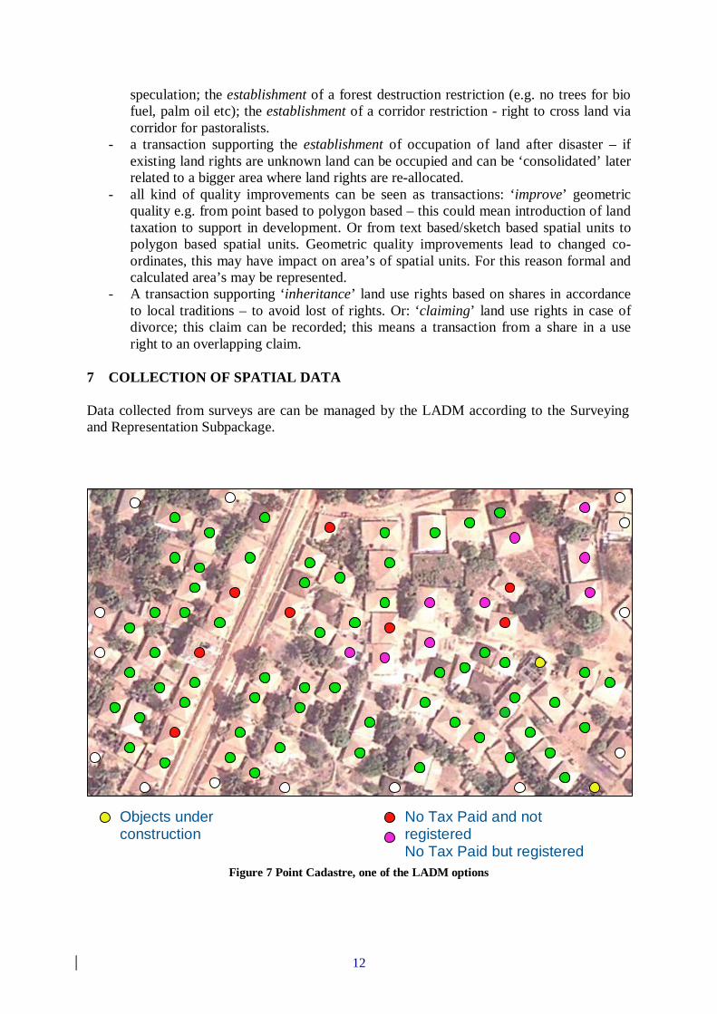
7 COLLECTION OF SPATIAL DATA Data collected from surveys are can be managed by the LADM according to the Surveying and Representation Subpackage.
Figure 7 Point Cadastre, one of the LADM options
Photo Identifier Name of Inspector
Objects under construction Neighbor Inspector
No Tax Paid and not registered No Tax Paid but registered Tax Paid
13
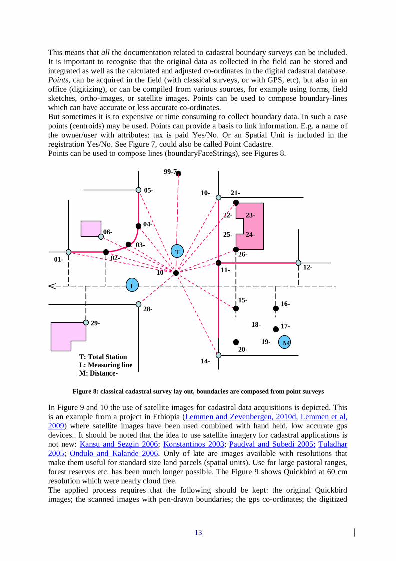
This means that all the documentation related to cadastral boundary surveys can be included. It is important to recognise that the original data as collected in the field can be stored and integrated as well as the calculated and adjusted co-ordinates in the digital cadastral database. Points, can be acquired in the field (with classical surveys, or with GPS, etc), but also in an office (digitizing), or can be compiled from various sources, for example using forms, field sketches, ortho-images, or satellite images. Points can be used to compose boundary-lines which can have accurate or less accurate co-ordinates. But sometimes it is to expensive or time consuming to collect boundary data. In such a case points (centroids) may be used. Points can provide a basis to link information. E.g. a name of the owner/user with attributes: tax is paid Yes/No. Or an Spatial Unit is included in the registration Yes/No. See Figure 7, could also be called Point Cadastre. Points can be used to compose lines (boundaryFaceStrings), see Figures 8.
Figure 8: classical cadastral survey lay out, boundaries are composed from point surveys
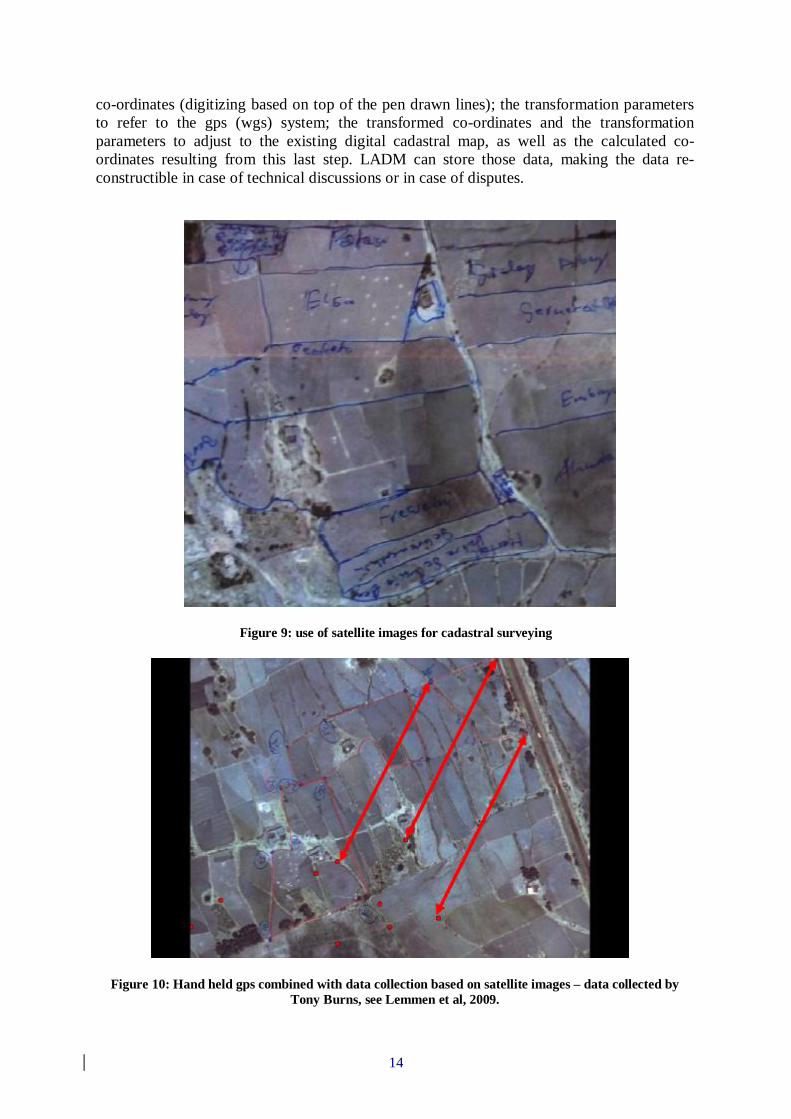
In Figure 9 and 10 the use of satellite images for cadastral data acquisitions is depicted. This is an example from a project in Ethiopia (Lemmen and Zevenbergen, 2010d, Lemmen et al, 2009) where satellite images have been used combined with hand held, low accurate gps devices.. It should be noted that the idea to use satellite imagery for cadastral applications is not new: Kansu and Sezgin 2006; Konstantinos 2003; Paudyal and Subedi 2005; Tuladhar 2005; Ondulo and Kalande 2006. Only of late are images available with resolutions that make them useful for standard size land parcels (spatial units). Use for large pastoral ranges, forest reserves etc. has been much longer possible. The Figure 9 shows Quickbird at 60 cm resolution which were nearly cloud free. The applied process requires that the following should be kept: the original Quickbird images; the scanned images with pen-drawn boundaries; the gps co-ordinates; the digitized
01-1
02-3
03-4
04-3
05-2
06-7
29-7
28-7
100
99-7 (orientation)
10-1
21-5
22-2
23-2 24-2
25-2
26-2
12-2
11-2
15-1 16-
2
17-2
18-2
19-2 20-
8 14-2
T
L
MT: Total Station L: Measuring line M: Distance-series
14
co-ordinates (digitizing based on top of the pen drawn lines); the transformation parameters to refer to the gps (wgs) system; the transformed co-ordinates and the transformation parameters to adjust to the existing digital cadastral map, as well as the calculated co-ordinates resulting from this last step. LADM can store those data, making the data re-constructible in case of technical discussions or in case of disputes.
Figure 9: use of satellite images for cadastral surveying
Figure 10: Hand held gps combined with data collection based on satellite images – data collected by Tony Burns, see Lemmen et al, 2009.
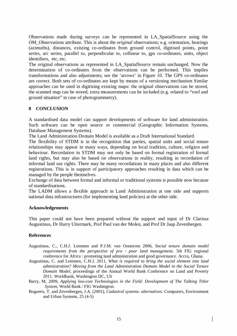
15
Observations made during surveys can be represented in LA_SpatialSource using the OM_Observations attribute. This is about the original observations; e.g. orientation, bearings (azimuths), distances, existing co-ordinates from ground control, digitised points, point series, arc series, parallel to, perpendicular to, collinear to, gps co-ordinates, units, object identifiers, etc, etc. The original observations as represented in LA_SpatialSource remain unchanged. Now the determination of co-ordinates from the observations can be performed. This implies transformations and also adjustments; see the ‘arrows’ in Figure 10. The GPS co-ordinates are correct. Both sets of co-ordinates are kept by means of a versioning mechanism Similar approaches can be used in digitising existing maps: the original observations can be stored, the scanned map can be stored, extra measurements can be included (e.g. related to “roof and ground situation” in case of photogrammetry). 8 CONCLUSION A standardised data model can support developments of software for land administration. Such software can be open source or commercial (Geographic Information Systems, Database Management Systems). The Land Administration Domain Model is available as a Draft International Standard. The flexibility of STDM is in the recognition that parties, spatial units and social tenure relationships may appear in many ways, depending on local tradition, culture, religion and behaviour. Recordation in STDM may not only be based on formal registration of formal land rights, but may also be based on observations in reality, resulting in recordation of informal land use rights. There may be many recordations in many places and also different registrations. This is in support of participatory approaches resulting in data which can be managed by the people themselves. Exchange of data between formal and informal or traditional systems is possible now because of standardisations. The LADM allows a flexible approach in Land Administration at one side and supports national data infrastructures (for implementing land policies) at the other side. Acknowledgements This paper could not have been prepared without the support and input of Dr Clarissa Augustinus, Dr Harry Uitermark, Prof Paul van der Molen, and Prof Dr Jaap Zevenbergen. References Augustinus, C., C.H.J. Lemmen and P.J.M. van Oosterom 2006, Social tenure domain model
requirements from the perspective of pro - poor land management. 5th FIG regional conference for Africa : promoting land administration and good governance. Accra, Ghana.
Augustinus, C. and Lemmen, C.H.J. 2011, What is required to bring the social element into land administration? Moving from the Land Administration Domain Model to the Social Tenure Domain Model, proceedings of the Annual World Bank Conference on Land and Poverty 2011. Worldbank, Washington DC, US
Barry, M, 2009, Applying low-cost Technologies in the Field: Development of The Talking Titler System, World Bank / FIG Washington.
Bogaerts, T. and Zevenbergen, J.A. (2001), Cadastral systems: alternatives. Computers, Environment and Urban Systems, 25 (4-5)
16
FIG-ITC-ESRI 2003 Proceedings of the Workshop on Cadastral Data Modeling, March 17-18, 2003, Enschede, The Netherlands
Fourie, Clarissa 1998 An integrated geo-information system with emphasis on cadastre and land information systems for decesion makers in Africa, working document for the expert group meeting held at United Nations Economoc Commission for Africa, Addis Ababa, Ethiopia, 23 – 26 November 1998.
GIM International FIG Special, May 2011, http://www.gim-international.com/news/id5799-GIM_International_FIG_Special.html
Henssen, J.L.G. 1995. Basic principles of the main cadastral systems in the world. In Proceedings of the One Day Seminar held during the Annual Meeting of Commission 7, Cadastre and Rural Land Management, of the International Federation of Surveyors (FIG), May 16, Delft, The Netherlands.
ISO/TC 211 2011. ISO 19152. Draft International Standard (DIS), Geographic information - Land administration domain model (LADM). Lysaker, Norway: ISO
Kansu, Oguz and Sezgin Gazioglu, ’ The availability of the satellite image data in digital cadastral map production’, XXIII International FIG Congress: Shaping the change, 8-13 October 2006, Munich, Germany
Kaufmann, J. and D. Steudler (1998). Cadastre 2014 - A vision for a future cadastral system. FIG XXI International Congress. Brighton, U.K.
Konstantinos, Christodoulou, ‘Combination of satellite image Pan IKONOS-2 with GPS in cadastral applications’, UN/ECE WPLA Workshop on Spatial Information Management for Sustainable Real Estate Market Best Practice Guidelines on Nation-wide Land Administration, 28-31 May 2003, Athens, Greece
Lemmen, C.H.J. and P.J.M. van Oosterom 2003a. Further progress in the development of a core cadastral domain model. FIG Working Week 2003. Paris, France.
Lemmen, C.H.J., P. van der Molen, P.J.M. van Oosterom, H. Ploeger, C.W. Quak, J.E. Stoter and J. Zevenbergen 2003b. A modular standard for the cadastral domain. Proceedings Digital Earth 2003. Information Resources for Global Sustainability. Brno, Czech Republic.
Lemmen, C.H.J., Zevenbergen, J.A., Lengoiboni, M., Deininger, K. and Burns, T.R. 2009 First experiences with high resolution imagery based adjudication approach for social tenure domain models in Ethiopia. In: Proceedings FIG - World Bank Conference : Land governance in support of the Millennium development goals, responding to new challenges, 9-10 March, 2009, Washington, D.C. 22 p.
Lemmen, C.H.J., P.J.M. van Oosterom, C. Eisenhut and H.T. Uitermark 2010a. The modelling of rights, restrictions and responsibilities (RRR) in the Land Administration Domain Model (LADM). XXIV FIG International Congress 2010. Sydney, Australia.
Lemmen, C.H.J., P.J.M. van Oosterom, R.J. Thompson, J. Hespanha and H.T. Uitermark 2010b. The modelling of spatial units (parcels) in the Land Administration Domain Model (LADM). XXIV FIG International Congress 2010. Sydney, Australia.
Lemmen, C.H.J. 2010c The social tenure domain model: a pro-poor land tool. FIG Publication no 52. Copenhagen, International Federation of Surveyors (FIG), 2010. ISBN: 978-87-90907-83-9.
Lemmen, C.H.J. and Zevenbergen, J.A. 2010d First experiences with high - resolution imagery - based adjudication approach in Ethiopia. In: Innovations in land rights recognition, administration and governance : joint organizational discussion paper issue 2 : proceedings from the annual conference on land policy and administration / K. Deininger, ... [et al.]. - Washington D.C. : The World Bank, 2010. 96-104
Lemmens, Mattias, (2010), Mobile GIS Systems, GIM International, December 2010, Volume 24, Number 12
Milindi Rugema, D. 2011 Evaluation of digital pen in data capturing for land administration purposes in Rwanda. Enschede, University of Twente Faculty of Geo-Information and Earth Observation ITC
Ondulo, Joe-Duncan and Kalande, William, 2006, ‘High Spatial Resolution Satellite Imagery for PID Improvement in Kenya’, Shaping the Change, XXIII FIG Congress, Munich, Germany, October 8-13, 2006.
17
Prastowo, H. 2011, Performance evaluation of digital pen for capturing data in land information systems, LIS. Enschede, University of Twente Faculty of Geo-Information and Earth Observation ITC, 2011.
Paudyal, Dev Raj & Nab Raj Subedi, ‘Identification of informal settlement by integration of cadastral information and remote sensing satellite imagery’, A Seminar on Space Technology Application and recent development in geo-spatial products in Kathmandu, Nepal, August 19, 2005
Tuladhar, Arbind Man, ‘Innovative use of remote sensing images for pro-poor land management’, FIG Expert Group Meeting on Secure Land Tenure: New Legal Frameworks and Tools, Bangkok, Thailand, December 2005
UN-HABITAT 2008. Secure land rights for all. Nairobi, Kenya, United Nations Human Settlements Programme: 40pp.
Van Oosterom, P.J.M., C.H.J. Lemmen, T. Ingvarsson, P. van der Molen, H. Ploeger, C.W. Quak, J.E. Stoter and J. Zevenbergen 2006. The core cadastral domain model. Computers, Environment and Urban Systems 30 (5) 627-660.
Van Oosterom, P.J.M., C.H.J. Lemmen and P. van der Molen 2004. Remarks and observations related to the further development of the Core Cadastral Domain Model. Workshop Standardization in the Cadastral Domain. Bamberg, Germany, FIG: pp. 175-192.
Williamson, I.P., S. Enemark, J. Wallace and A. Rajabifard, (2010). Land administration for sustainable development. Redlands, California, U.S.A., ESRI Press
Zerfu Hailu and Lennart Backstrom, Ethiopia, 2006, Land Administration in Ethiopia, Model for Establishing Tenure Security in Other Countries, GIM International, February 2006.