iron range brownfield assessment coalition site ... · petroleum remediation program (prp)...
TRANSCRIPT
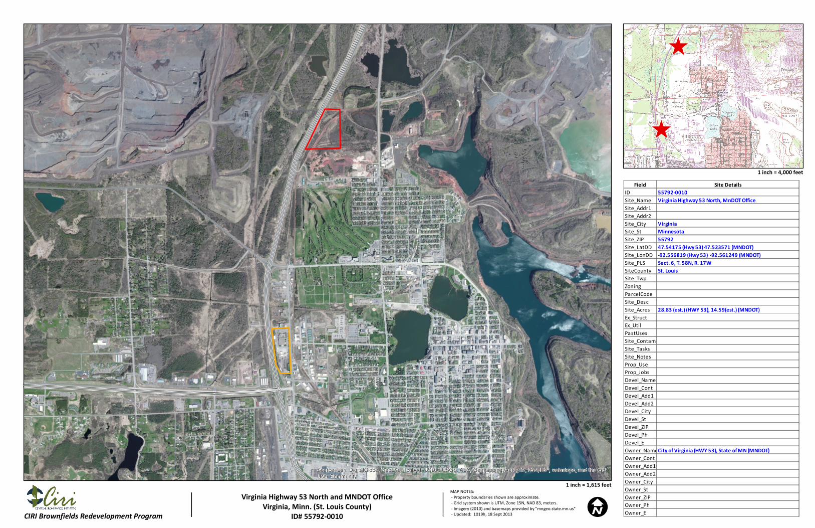
Iron Range Brownfield Assessment Coalition Site Eligibility and Property Ownership Determination Community: City of Virginia Sites: Virginia Highway 53 North Property, and MnDOT Office Property Date: January 30, 2014 A. Basic Site Information: Name: Virginia Highway 53 North property, and Minnesota Department of Transportation (MnDOT) Office property The Virginia Highway 53 North site is generally referred to as land along the east side of Highway 53, on the north side of the City of Virginia. The MnDOT Office site serves as both a truck station and as the headquarters for the Range Sub-Area of District 1. Location: Together, both properties consist of approximately 43.39 acres within the city limits of Virginia, Minnesota. The Virginia Highway 53 North property consists of approximately 28.8 acres. The Site is near the northern and western city limits. P&H Road is adjacent to the northern property border, and Highway 53 is adjacent to the western property border. The MnDOT Office property is located at 101 North Hoover Road, and consists of approximately 14.59 acres near the western city limits. Hoover Road is adjacent to the eastern property border, and Highway 53 is adjacent to the western property border. Legal Description: The Virginia Highway 53 North site includes Saint Louis County parcel number 090-0180-00142, as well as the eastern Highway 53 easement between P&H Road to the north and 18th Street North to the south. The property is in the northwest quarter of Section 6, Township 58 north, Range 17 west. Saint Louis County parcel number 090-0180-00142 is legally described as: That part of Lot 3 lying easterly of easterly right-of-way line of Highway Number 53. The MnDOT Office property consists of Saint Louis County parcel number 090-0190-00080. The property is in the southeast quarter of Section 12, Township 58 north, Range 18 west. Saint Louis County parcel number 090-0190-00080 is legally described as: Nly 1580.16 ft of E ½ of SE ¼ lying ely of new Hwy 53 ex sly 560 ft of ely 233 ft. Ownership: The City of Virginia purchased the Virginia Highway 53 North property from U.S. Steel in 2002, as described in Saint Louis County document number 870955. The MnDOT Office property was granted to the State of Minnesota from the United States of America as part of the Swamp Land Patent No. 19. The land transfer is

described in Saint Louis County document number 526175, dated July 1991. The document was originally filed in the state land office in approximately 1885. Historical Use and Development: The Virginia Highway 53 North property is located in an industrial part of the City of Virginia, near the northern and western city limits. A Duluth Missabe and Iron Range (DM&IR) railroad spur with multiple sidings is visible crossing the Property from the southwest to the northeast on the Virginia, Minnesota United States Geological Survey (USGS) 7.5-Minute Series topographic map dated 1985. A single-track spur is also visible along the southern Property boundary. According to the City of Virginia’s Engineering Department, the property was previously used for railroad track, and to temporarily store material from the nearby mine prior to loading the material onto rail cars to be transported off site. The MnDOT Office property is located in an industrial part of the City of Virginia, near the western city limits. The building currently utilized for MnDOT offices appears to be visible on the Virginia, Minnesota USGS 7.5-Minute Series topographic map dated 1985. B. and E. Regulatory Summary:
1. No prior environmental assessments are known to have been completed for the Virginia Highway 53 North property.
2. The Virginia Highway 53 North property was not found in the Minnesota Pollution Control Agency (MPCA) database for Minnesota Aboveground/Underground Storage Tanks, and was not identified as a leak site.
3. The MnDOT Office site is listed in the MPCA database for Minnesota Aboveground/Underground Storage Tanks under Tank Site #5403 (five removed tanks and one closed-in-place tank) and under Tank Site #51408 (eight removed tanks and twelve active tanks).
4. The MnDOT Office property is listed as a closed leak site in the MPCA Petroleum Remediation Program (PRP) database. A release of an unknown petroleum product was discovered in July 1993, and the site was assigned Leak ID #7618. According to the PRP database, no free product was observed, contaminated soils remained on site, and it was unknown whether groundwater was contaminated. The leak site was granted complete closure in March 1995 after a remedial investigation was conducted.
C. Eligibility Screening:
1. The site is not listed or proposed for listing on the National Priorities List. 2. The site is not subject to unilateral administrative orders, court orders,
administrative orders on consent, or jurisdictional consent decrees issued to or entered into by parties under CERCLA.
3. The site is not subject to the jurisdiction or control of the United States Government.
D. Requirement for a Property Specific Determination: The site does not require a Site Specific Determination.
F. CERCLA 107 Liability: The City of Virginia obtained the Virginia Highway 53 North property in 2002; no prior environmental assessments are known to have been completed for this property. The State of Minnesota currently owns the MnDOT Office property. The only known prior environmental assessment completed for the MnDOT Office property is the remedial investigation conducted in association with Leak ID #7618. G. Enforcement Actions: There are no known or anticipated federal, state, or local enforcement actions. One closed leak site (Leak ID #7618) is on file with the MPCA for the MnDOT Office property. H. Information on Liability and Defenses: Pre-purchase inquiry: See part B and E. Post Acquisition Uses: The City of Virginia plans to use the Virginia Highway 53 North site for both city maintenance garages and Minnesota Department of Transportation garages. Additionally, the City of Virginia would like to purchase the MnDOT Office property and redevelop the parcel for commercial or industrial use. Continuing obligations: There are no known continuing obligations. The MnDOT Office property is still in use as a truck station and sub-area headquarters for MnDOT. Additional information related to Petroleum Eligibility:
1. The Virginia Highway 53 North property is not currently identified in MPCA databases as a tank site or a leak site.
2. The MnDOT Office site is identified in MPCA databases as Tank Site #5403 (five removed tanks and one tank that was closed-in-place) and as Tank Site #51408 (eight removed tanks and twelve active tanks).
3. The leak site (Leak ID #7618) associated with the MnDOT Office property was granted closure by the MPCA in 1995 and is considered low-risk. MnDOT is the responsible party for this leak site.
4. Neither property is subject to a RCRA corrective action order.
Source: Esri, DigitalGlobe, GeoEye, i-cubed, USDA, USGS, AEX, Getmapping, Aerogrid, IGN, IGP, swisstopo, and the GIS
User Community
ICIRI Brownfields Redevelopment Program
^
^
MAP NOTES:
- Property boundaries shown are approximate.
- Grid system shown is UTM, Zone 15N, NAD 83, meters.
- Imagery (2010) and basemaps provided by "mngeo.state.mn.us"
- Updated: 1019h, 18 Sept 2013
1 inch = 4,000 feet
1 inch = 1,615 feet
Virginia Highway 53 North and MNDOT Office
Virginia, Minn. (St. Louis County)
ID# 55792-0010
Field Site Details
ID 55792-0010
Site_Name Virginia Highway 53 North, MnDOT Office
Site_Addr1
Site_Addr2
Site_City Virginia
Site_St Minnesota
Site_ZIP 55792
Site_LatDD 47.54175 (Hwy 53) 47.523571 (MNDOT)
Site_LonDD -92.556819 (Hwy 53) -92.561249 (MNDOT)
Site_PLS Sect. 6, T. 58N, R. 17W
SiteCounty St. Louis
Site_Twp
Zoning
ParcelCode
Site_Desc
Site_Acres 28.83 (est.) (HWY 53), 14.59(est.) (MNDOT)
Ex_Struct
Ex_Util
PastUses
Site_Contam
Site_Tasks
Site_Notes
Prop_Use
Prop_Jobs
Devel_Name
Devel_Cont
Devel_Add1
Devel_Add2
Devel_City
Devel_St
Devel_ZIP
Devel_Ph
Devel_E
Owner_NameCity of Virginia (HWY 53), State of MN (MNDOT)
Owner_Cont
Owner_Add1
Owner_Add2
Owner_City
Owner_St
Owner_ZIP
Owner_Ph
Owner_E