invasive plants in the falkland islands - defra,...
TRANSCRIPT

Invasive Plants in the Falkland Islands
Final Report
Richard Lewis, Royal Botanic Gardens, Kew
March 2014

2
Abbreviations FC Falklands Conservation FIG GIS
Falkland Islands Government Geographical Information System
MPA MPC
Mount Pleasant Airfield Mount Pleasant Complex
RBG, Kew SAERI
Royal Botanic Gardens, Kew South Atlantic Environment Research Institute
UKOT United Kingdom Overseas Territory

3
Executive Summary
Invasive non-native plants are a significant threat to native biodiversity and agricultural productivity in the Falkland Islands. The Falkland Islands Government is currently developing a new Strategy for managing invasive plants. The Strategy will identify and designate responsibility for invasive plant issues across government departments, the private sector and NGOs, along with funding to support action.
The aim of this research was to provide the evidence to underpin the development of a draft Strategy and to provide the evidence to help Falklands Island Government and other stakeholders:
a. Understand the current nature and extent of established invasive species; and
b. Prioritise and strengthen intervention.
Nature and extent of established species
Extensive surveys of the Falkland Islands were undertaken to update maps of non-native species distribution. Areas surveyed included Saunders Island, Keppel Island, South Harbour, Purvis House, River Island, Weddell Island, Kelp Creek, Loop Head, Pebble Island, Marble Mountain and Mt Rosalie. Updated maps of the Falklands Flora were produced using data from these surveys and were published separately in an earlier phase of the project: www.falklandsconservation.com/wildlife/plants (Upson & Lewis 2013).
Herbarium specimens and associated DNA samples were taken from all new species encountered; species not already represented adequately in herbaria.
Prioritising intervention
The rate at which new introduced species are being recorded in the Falklands, including 27 species identified for the first time during this project, is increasing. Biosecurity is likely to be the most effective and cheapest line of defence against the growing number of potentially invasive plants. Internal biosecurity actions are also potentially valuable tools to reduce the spread of species that have already arrived.
Risk assessment protocols were developed and implemented for 190 species where sufficient data were available from reliable, standardised sources. These assessments allow conservation and land managers to focus resources on to where they are likely to be most effective and are presented in the Annexes to this report (e.g. species of honeysuckle, berberis and clematis, such as Lonicera periclymenum, Berberis thunbergii and Clematis 'Jackmanii')
The project also assessed the ‘eradication impedance’ – the relative ease or difficulty with which invasive plats can be controlled.
A total of 80 non-native species were present in four or fewer 10km grid squares. 71 of these are identified as a high priority for control due to high risk assessment score (>13), low eradication impedance (<19) or low net area (<0.1). In other words these species are not currently widespread, and can be eradicated relatively easily, but would have long-term impacts if left unmanaged.
A large number of high-risk invasive plants are widespread within the Falkland Islands. For many, eradication may not be effective. However, 14 widespread high-risk invasive species were identified where control would be possible:
Achillea millefolium Ulex europaeus
Cirsium arvense Rumex crispus
Cirsium vulgare Rumex obtusifolius
Pilosella officinarum Rumex longifolius
Sonchus asper Pilosella aurantiaca
Berberis microphylla Ammophila arenaria
Calluna vulgaris Senecio squalidus
The research provides an evidence base for targeting resources at the control and management of invasive plant species. The evidence base has informed the production of a draft Invasive Plants Strategy for the Falkland Islands.
4
Contents Abbreviations .......................................................................................................................................... 2 Executive Summary ................................................................................................................................ 3 1. Background ......................................................................................................................................... 5 2. Objectives ........................................................................................................................................... 6 3. Methods............................................................................................................................................... 6
3.1 Field data capture .......................................................................................................................... 6 Data storage .................................................................................................................................... 6
3.2 Surveys for thistle and ragwort species ......................................................................................... 7 3.3 Checklist and species distributions ............................................................................................... 7 3.4 Early intervention control ............................................................................................................... 8 3.4.1 Prioritisation ................................................................................................................................ 8
3.4.2 Survey and research ............................................................................................................... 9 3.4.3 Control and monitoring ........................................................................................................... 9
3.5 Risk assessment ........................................................................................................................... 9 4. Results & discussion ......................................................................................................................... 10
4.1.1 Keppel Island population ...................................................................................................... 10 4.1.2 Saunders Island population .................................................................................................. 11 4.1.3 Monitoring and control protocols........................................................................................... 12
4.2. Checklist and species distributions ............................................................................................ 13 4.2.1 Checklist ............................................................................................................................... 13 4.2.2 Species distributions ............................................................................................................. 14
4.3 Early intervention control ............................................................................................................. 15 4.3.1 Prioritisation .......................................................................................................................... 15 4.3.2 Control and Monitoring ......................................................................................................... 16 4.3.3 Survey ................................................................................................................................... 19 4.3.4 Research ............................................................................................................................... 19
4.4 Falkland Islands Invasive Plants Strategy ................................................................................... 21 4.5 Enhancing local capacity ............................................................................................................. 21
4.5.1 Training ................................................................................................................................. 21 4.5.2 Invasive plant ID ................................................................................................................... 21 4.5.3 Support for ongoing control of widespread invasive species ............................................... 21
4.6 Publications ................................................................................................................................. 21 4.6.1 General publications ............................................................................................................. 21 4.6.2 Scientific publications ........................................................................................................... 22
5. Conclusions ....................................................................................................................................... 23 6. Additional outcomes .......................................................................................................................... 25 References ............................................................................................................................................ 26 Appendix 1: Volunteer invasive plant recording sheet Appendix 2: Eradication effort scoring system Appendix 3: Calendar of early intervention control actions Appendix 4: Risk assessment of cultivated species Appendix 5: Extract from A Checklist and Atlas of the Falkland Islands Flora Appendix 6: List of herbarium specimens collected Appendix 7: Prioritised shortlists of species also found in cultivation
5
1. Background This project was funded by Defra as part of their commitment to assist OTs in conserving biodiversity by facilitating research partnerships that bring together UK research expertise and local knowledge. Invasive non-native plants pose a number of threats to both agriculture and the unique biodiversity of the Falkland Islands. The Falkland Islands Biodiversity Strategy 2008-2018 (FIG 2008) identified invasive species as a high priority threat and a critical knowledge gap. These threats have only relatively recently been formally identified, but significant progress has been made since 2006 by Falklands Conservation (FC), the Falkland Islands Government (FIG), the South Atlantic Invasive Species Project (SAISP), and the Royal Botanic Gardens, Kew (RBG, Kew). Research and control actions have targeted a number of invasive plant species, including Thistles (Cirsium vulgare and C. arvense), Ragworts (Senecio jacobea and S. squalidus) and precautionary early intervention control of over 20 species that have only recently become established in the Falklands. At present, these control actions are being funded and co-ordinated on a short-term and fairly ad-hoc basis. Management plans have been drafted for some species, but these do not cover all the highest priority species and there is no overall co-ordination or long-term funding of control actions, nor a structured programme of research to tackle the most significant knowledge gaps. The Annex to Convention on Biological Diversity (CBD) Decision VI/23 sets out 15 Guiding Principles for the Prevention, Introduction and Mitigation of Impacts of Alien Species that Threaten Ecosystems, Habitats or Species. Guiding Principle 2 recommends a three stage hierarchical approach to managing invasive species: prevention; eradication; containment and control.
Biosecurity is the most effective and affordable option to prevent the impacts of invasive species.
After biosecurity, early detection and intervention to eradicate invasive species before they become established is the next most effective solution.
Once a species becomes widespread and established, ongoing control may be the only way to reduce the impacts, though this may be expensive or unsuccessful.
This project supported actions across all three strands of invasive plant management. Effective biosecurity, eradication and control all rely on accurate and up-to-date information on the risks, status and distribution of introduced species and a number of important knowledge gaps have been filled. Whilst biosecurity should always be the highest priority, there is strong scope within the Falklands to eradicate a large number of introduced species and this project aims to support development of a program to eradicate species where this is practical. The likely success of a plant eradication campaign is strongly linked to the initial area of infestation (Rejmánek & Pitcairn, 2002) and at least half of all introduced species in the Falklands have a very limited distribution or may already be locally extirpated (Broughton & McAdam, 2002a). Thus, over half of the introduced species in the Falklands are potential candidates for early intervention eradication to stop them spreading and potentially becoming more widely established and causing negative economic or conservation impacts. Whilst programs to control established invasive plant species are often expensive and prone to failure, there is still a need to address the conservation and economic impacts of these species. Some control has already occurred for a number of species and some of this is likely to continue. This project addressed some important knowledge gaps for Thistles and Ragworts (Cirsium spp. and Senecio spp.), two sets of more widespread species which have been previously targeted for control over several years, and which are not yet so widespread that effective control is impossible. Overall, this project aimed to address a number of areas to support the development and future implementation of a co-ordinated, effective and prioritised strategy for managing invasive plants. The separate strands of this project are summarised in the objectives laid out in section 2. The first four objectives closed some of the most significant knowledge gaps, allowing more effective co-ordination and prioritisation of future control actions. Effective management of invasive plants typically requires many years of co-ordinated action and few management goals can be achieved within the time frame of a short-term project. Therefore, the latter three objectives develop a long-term strategy to guide future management of invasive plants, and enhance local capacity to undertake this management in future.
6
2. Objectives 1. Complete a survey of Thistles (Cirsium vulgare, C. arvense) and Ragworts (Senecio jacobea, S.
squalidus), targeting all recent and historic records and the most likely potential sites.
2. Undertake surveys to record baseline data (checklists and distributions) for all non-native plant species.
3. Develop and implement protocols for early intervention control of at least 20 potentially invasive species.
4. Undertake risk assessments for cultivated non-native plant species.
5. Collate all data to develop a long-term strategy for the prevention, control and eradication of invasive non-native plants in the Falkland Islands, in liaison with FIG and other relevant stakeholders.
6. Enhance existing local capacity to research and control invasive non-native plants, through training of local workers and volunteers; provision of appropriate information and materials; and liaising with FIG and local workers to support implementation and expansion of existing control programmes.
7. Communicate results to general, scientific and government audiences.
3. Methods
3.1 Field data capture All data were collected using standard recording protocols in line with the data gathering standards of the UKOTs Conservation Program at RBG, Kew (Hamilton, 2008). Data were collected in the field using handheld personal digital assistants (PDAs, Fujitsu-Siemens LOOX N560) with an in-built Global Positioning System (GPS) and housed in waterproof cases (Otterbox). ArcPad software (Version 7.1, ESRI) was used to record standardised, geo-referenced data on forms which included a set of dropdown menus and freestyle text fields. A small amount of additional data was gathered by volunteers using a printed recording sheet which is based on a simplified version of this protocol (see Appendix 1).
Data storage The data are stored as dbf files and organised using the Botanical Research and Herbarium Management System (BRAHMS); these are linked to the ARCmap Geographical Information System (ESRI) which allows mapping and visualization of the data. Under the current memorandum of understanding between the RBG, Kew and the FIG, all data recorded are owned by the Falkland Islands Government and are managed by RBG, Kew. In line with this, the data from this project have been submitted to the RBG, Kew and will be further cleaned and processed by colleagues at the RBG, Kew alongside other plant data which is being processed in preparation for the publication of a Checklist of the Falklands flora. After this cleaning and processing is complete, the data will be combined with Kew’s existing Falklands’ vascular plant database and will be made available through the UKOTs online herbarium (http://herbaria.plants.ox.ac.uk/bol/UKOT). An updated copy of the database will also be provided to Falklands Conservation in Stanley, on behalf of FIG, in order to facilitate access to the dataset within the Falklands. This database will also be available to the national GIS centre currently being developed by SAERI.

7
3.2 Surveys for Thistles and Ragworts All known sites for all target species were surveyed, with the exception of Douglas Station which is a historic record and not re-recorded during surveys in 2000. Access to areas of MPA and Mare Harbour was restricted due to security precautions, so data for these sites were gathered by residents and workers at MPA, in the form of an annotated map. Due to security restrictions, this map is only available to personnel and contractors at MPA and copies are held by the MPA conservation group and Interserve Defence Limited, the contractors undertaking invasive plants control at the base. Additional likely sites identified were all military-related locations and a group of small islands downwind of Keppel Island. Several military sites close to MPA were surveyed, along with all three mountain-top RADAR bases. It was not possible to access the Onion Range or Victoria Harbour sites due to security precautions. Despite two attempts, logistical problems made it impossible to survey the group of small islands near Keppel Island. Detailed geo-referenced baseline data were collected for the populations of Cirsium vulgare on Saunders Island. More limited baseline geo-referenced data were also recorded for the population of Cirsium vulgare on Keppel Island. Monitoring and control protocols were established for both these Cirsium vulgare populations. Data were collected by conducting initial assessment and mapping of high, medium and low density areas of the populations during site visits in 2011/12. High and medium density areas were identified as core areas, and in 2012/13 they were assessed in detail using a stratified random sampling using 4x4m quadrats. These were marked on the ground with metal pegs and either wooden marker posts or rocks to allow repeated observations. Due to the large area and uneven and disorienting terrain of the lower density areas, GIS shapefiles were developed with walking paths at approximately 40m intervals. At the Saunders Island site, these were used in conjunction with ArcPAD GIS on handheld PDAs to thoroughly cover the entire area of the lower density populations, including an area up to 150m outside the most outlying thistles recorded, and all subpopulations encountered were individually mapped and recorded.
3.3 Checklist and species distributions Nine sites were fully surveyed. These are South Harbour, Purvis House, River Island, Weddell Island, Kelp Creek, Loop Head, Pebble Island, Marble Mountain and Mt Rosalie. This includes settlements, outside houses and shanties; and both inhabited and abandoned locations. In addition, four settlements have been partially surveyed; these are Port Howard, Fox Bay West, Fox Bay East and Roy Cove.
For sites which have been fully surveyed, full species lists of both cultivated and non-cultivated species were produced for at least three gardens in each settlement. In addition, all other disturbed or anthropogenic habitats (including other gardens) within a 1km circumference of the settlement have been surveyed and any additional species recorded.
Herbarium specimens and associated DNA samples were taken from all new species encountered; species not already represented adequately in herbaria; species where detailed observation is required for confident identification; and species where further taxonomic research is required.
In collaboration with Dr Rebecca Upson of RBG, Kew, data collected during these surveys were collated and analysed, together with a range of other data sources, to produce an updated checklist and atlas.
8
3.4 Early intervention control
3.4.1 Prioritisation All known introduced species present in four or fewer 10km grid squares (Broughton & McAdam, 2002) and all species identified as being of high risk (Whitehead, 2008; Hartikainen, 2009) were assessed according to their risk assessment score and the feasibility of eradication. This subset was chosen as the intention is to target species with limited distributions and the most complete data set available comprises presence/absence at the 10km grid square level. Feasibility of eradication was assessed using a modified version of the two-part process developed by Panetta & Timmins (2004) for Australia, which has also been used to prioritise plant eradications in the Galapagos Islands (Panetta et al, 2011). Firstly, a decision tree identifies a range of species for which eradication is unsuitable. In the Falklands context, this is currently limited to species cultivated for ornamental or agricultural purposes. However, eradication of naturalised populations of cultivated species may still be beneficial so these were analysed separately to draw up priorities for possible future actions. Secondly, species are scored on 10 questions to calculate a score of eradication impedance (I); and the net area of infestation (A, in ha) is also calculated. An eradication effort score (E) is then calculated as the product of A and I.
E = A x I This differs slightly from the process developed by Panetta & Timmins (2004), as data on area were very limited, so it was not possible to use gross area (the entire area that needs to be searched during each control) and net area (the actual area of ground covered by the target species) was used instead. As gross area is expected to be proportional to the net area the results are still expected to provide a useful guideline for initial prioritisation. Where data were absent, an estimate was used in accordance with the precautionary principle that it is better to have false positives than false negatives. The assessment process and full results are presented in Appendix 2. In total, 185 species were analysed, including 14 high-risk widespread species and 171 species with a distribution in the wild of four or fewer 10km grid squares. Of the latter, 80 are non-cultivated ‘weed’ species and 91 are cultivated species. As the dataset was comprised mainly of a subset of species with very limited distributions, ranking species solely on a single eradication score, which is heavily dependent on the species’ distributions, may not be the best approach and this scoring system was not designed to be applied solely to species with such limited distributions. As the costs of implementing control of such species are low, it is useful to take a precautionary approach and attempt control of as many species as possible. This may also allow a comparison of the differences in eradication success between species with different characteristics, providing a test for the validity of the scoring system under these circumstances. Therefore, it was decided to treat the risk assessment, eradication impedance (I) and net area (A) scores independently, alongside the overall eradication effort score (E). After evaluation of the results of the assessment, species with either a high risk-assessment score (>13), low eradication impedance (<19) or low net area (<0.1) were all considered high priority for eradication or control. Whilst it was outside the scope of this project to undertake cost/benefit analyses, it is expected that such analyses would likely conclude that some level of control of all these species is beneficial either due to potentially high costs of plant impacts; or because precautionary control is cheap and easily effected. Only species with risk-assessment, high eradication impedance and high net area were considered lower priority. Shortlists of potential candidates for control were drawn up, including separate shortlists of cultivated and non-cultivated ‘weed’ species. In applying this scoring process, it became evident that insufficient data were available to make a fully accurate assessment of many species, especially regarding the area of infestation and whether species were even still present as the only data for some species were from 1950-1970. Consequently, the two lists of high-priority species were each further divided: firstly priority species for eradication, including species where geo-referenced data for all known populations were available;
9
and secondly, priority species for further survey and research where only limited data on distribution and abundance were available, or where there were reasons to suspect the species may already be extirpated.
3.4.2 Survey and research Further survey was undertaken for species where data regarding distribution and abundance were limited, including some specific surveys of areas where target species had been recorded in the past. A number of additional species which had not previously been recorded were also identified during surveys. Where appropriate, herbarium or DNA vouchers were collected from species identified as requiring further research.
3.4.3 Control and monitoring All existing data regarding shortlisted ‘weed’ species were collated. Potential control techniques were identified and a calendar was drawn up for actions to monitor and control all species suitable for eradication. This is presented in Appendix 3. Most control and monitoring were undertaken by local trainees.
3.5 Risk assessment Initial investigations revealed that the existing risk assessment protocol is largely unsuitable for plants currently only known in cultivation. An alternative risk assessment protocol was therefore developed and implemented for 190 species where sufficient data were available from reliable, standardised sources. This was undertaken by an independent researcher and the full report is presented in Appendix 4.

10
4. Results & discussion 4.1 Surveys for Thistles and Ragworts In total 13 sites were identified, of which four held two or more of the target species. These are listed in Table 1. Six sites held populations of Cirsium vulgare, of which four comprised >1,000 plants and two comprised <100 plants. Nine sites held populations of C. arvense, of which six comprised <5 individuals and three comprised >50 individuals. Five sites held S. squalidus, of which four comprised <100 individuals and one >3000 individuals. Population numbers are given as estimates because C. vulgare and S. squalidus are annual or biennial and numbers fluctuate from year to year, whilst C. arvense reproduces clonally and it is often impossible to accurately distinguish separate individuals. Most of these populations have been subject to some control, though the extent and effectiveness of this control varies. The data gathered and monitoring protocols established will be useful in planning future control and evaluating effectiveness. Senecio jacobea was not found during this survey. No vouchered records exist and this species may have been misidentified for S. squalidus and may never have been present in the Islands. All data collected are geo-referenced and stored in the BRAHMS database as described in section 3.1. The only exception being data from MPA and Mare Harbour, which were collected by military personnel and are currently held as an annotated digital map, which is the form most useful to the personnel undertaking invasives control on MoD land. Table 1: Locations of Thistle and Ragwort species.
Location Cirsium vulgare Cirsium arvense Senecio squalidus
Stanley <10 >50 <100 Cape Pembroke1 <5 Teal Creek <5
Mount Pleasant (MPA) >1,000 >50 >3,000 Mare Harbour >1,000 >100 <100 Philimore Island >1,000*
Fox Bay <5 Mount Alice <5* Keppel Island1 >5,000 <5*
Saunders Island1 >6,000 Pebble Island <50* Fitzroy <30 Mount Kent <30* 1
These sites are Important Plant Areas (IPAs) * Populations first recorded 2011-13
4.1.1 Keppel Island population
829 thistle plants (339 mature plants and 490 1st year rosettes) were recorded from across 33
quadrats within the core areas of the main population in 2012/13, an average of 25 thistles per quadrat.
4645 thistle plants (3759 mature plants and 886 1
st year rosettes) were recorded, controlled and
mapped during an incomplete survey of the outlying areas of the main population in 2011/12. Both the higher density of plants in the core areas and the higher ratio of mature plants to rosettes are likely to reflect the lower intensity of control of this population in comparison to Saunders Island in previous years.
11
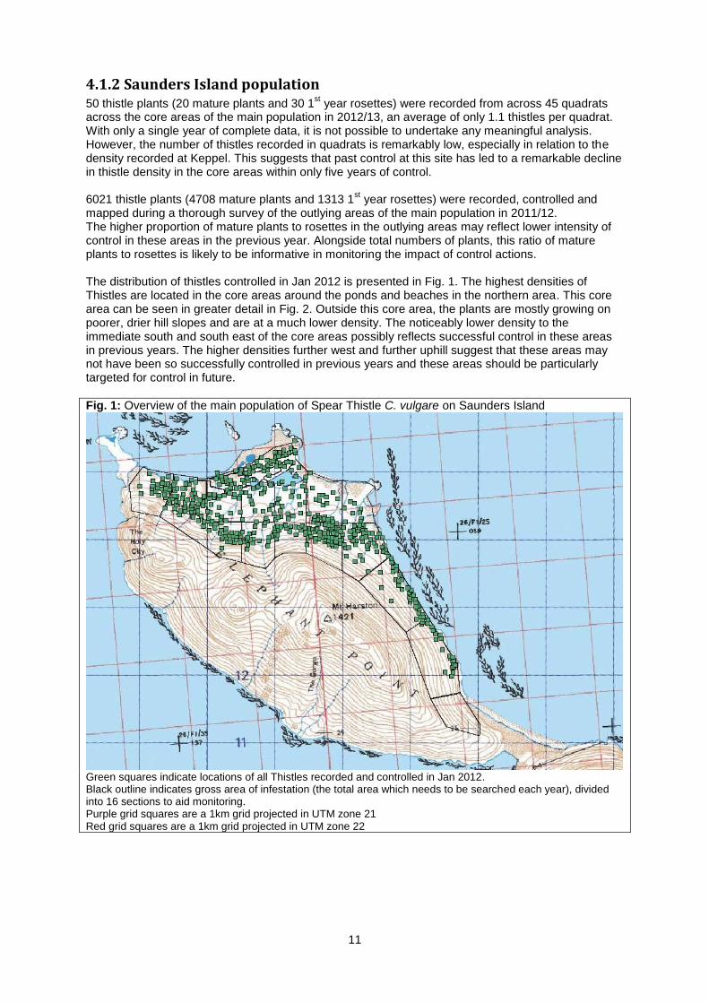
4.1.2 Saunders Island population 50 thistle plants (20 mature plants and 30 1
st year rosettes) were recorded from across 45 quadrats
across the core areas of the main population in 2012/13, an average of only 1.1 thistles per quadrat. With only a single year of complete data, it is not possible to undertake any meaningful analysis. However, the number of thistles recorded in quadrats is remarkably low, especially in relation to the density recorded at Keppel. This suggests that past control at this site has led to a remarkable decline in thistle density in the core areas within only five years of control. 6021 thistle plants (4708 mature plants and 1313 1
st year rosettes) were recorded, controlled and
mapped during a thorough survey of the outlying areas of the main population in 2011/12. The higher proportion of mature plants to rosettes in the outlying areas may reflect lower intensity of control in these areas in the previous year. Alongside total numbers of plants, this ratio of mature plants to rosettes is likely to be informative in monitoring the impact of control actions. The distribution of thistles controlled in Jan 2012 is presented in Fig. 1. The highest densities of Thistles are located in the core areas around the ponds and beaches in the northern area. This core area can be seen in greater detail in Fig. 2. Outside this core area, the plants are mostly growing on poorer, drier hill slopes and are at a much lower density. The noticeably lower density to the immediate south and south east of the core areas possibly reflects successful control in these areas in previous years. The higher densities further west and further uphill suggest that these areas may not have been so successfully controlled in previous years and these areas should be particularly targeted for control in future.
Fig. 1: Overview of the main population of Spear Thistle C. vulgare on Saunders Island
Green squares indicate locations of all Thistles recorded and controlled in Jan 2012. Black outline indicates gross area of infestation (the total area which needs to be searched each year), divided into 16 sections to aid monitoring. Purple grid squares are a 1km grid projected in UTM zone 21 Red grid squares are a 1km grid projected in UTM zone 22
12
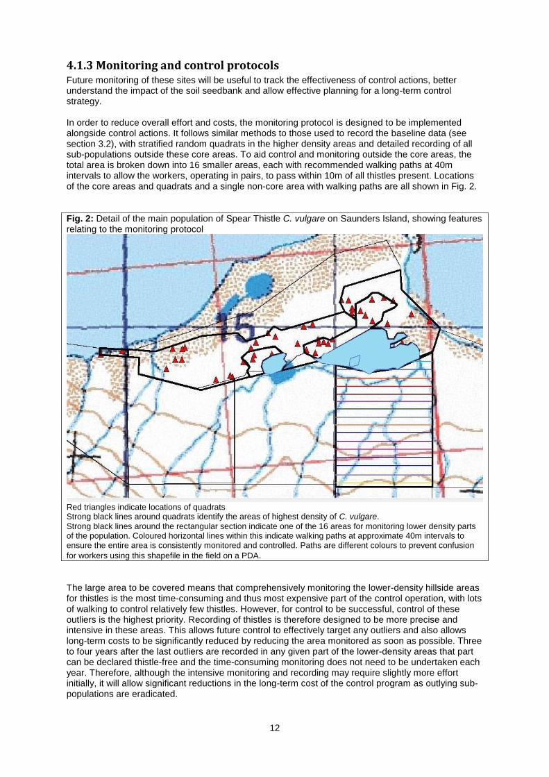
4.1.3 Monitoring and control protocols Future monitoring of these sites will be useful to track the effectiveness of control actions, better understand the impact of the soil seedbank and allow effective planning for a long-term control strategy. In order to reduce overall effort and costs, the monitoring protocol is designed to be implemented alongside control actions. It follows similar methods to those used to record the baseline data (see section 3.2), with stratified random quadrats in the higher density areas and detailed recording of all sub-populations outside these core areas. To aid control and monitoring outside the core areas, the total area is broken down into 16 smaller areas, each with recommended walking paths at 40m intervals to allow the workers, operating in pairs, to pass within 10m of all thistles present. Locations of the core areas and quadrats and a single non-core area with walking paths are all shown in Fig. 2.
Fig. 2: Detail of the main population of Spear Thistle C. vulgare on Saunders Island, showing features relating to the monitoring protocol
Red triangles indicate locations of quadrats Strong black lines around quadrats identify the areas of highest density of C. vulgare.
Strong black lines around the rectangular section indicate one of the 16 areas for monitoring lower density parts of the population. Coloured horizontal lines within this indicate walking paths at approximate 40m intervals to ensure the entire area is consistently monitored and controlled. Paths are different colours to prevent confusion
for workers using this shapefile in the field on a PDA.
The large area to be covered means that comprehensively monitoring the lower-density hillside areas for thistles is the most time-consuming and thus most expensive part of the control operation, with lots of walking to control relatively few thistles. However, for control to be successful, control of these outliers is the highest priority. Recording of thistles is therefore designed to be more precise and intensive in these areas. This allows future control to effectively target any outliers and also allows long-term costs to be significantly reduced by reducing the area monitored as soon as possible. Three to four years after the last outliers are recorded in any given part of the lower-density areas that part can be declared thistle-free and the time-consuming monitoring does not need to be undertaken each year. Therefore, although the intensive monitoring and recording may require slightly more effort initially, it will allow significant reductions in the long-term cost of the control program as outlying sub-populations are eradicated.

13
Shapefiles compatible with ArcGIS software containing these baseline data, quadrat locations and the recommended walking paths developed for control and monitoring of these sites are stored by FC on behalf of FIG. These shapefiles are compatible with the national GIS system being developed by SAERI. These shapefiles can also be used in the field in conjunction with the PDAs held by FC, or with similar software apps on smartphones.
4.2. Checklist and species distributions
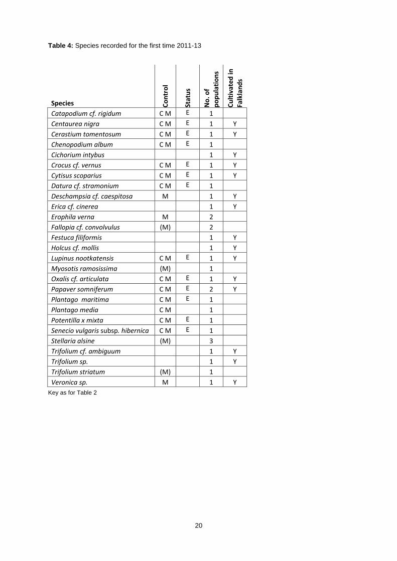
4.2.1 Checklist An Updated Checklist and Atlas of the Falklands Flora was produced using data from this project (Upson & Lewis, 2013) and is available on the Falklands Conservation website (http://www.falklandsconservation.com/wildlife/plants). The checklist has also been submitted for publication in an open-access peer-reviewed journal. An extract from the checklist and atlas, including a full list of introduced species and a discussion of their status and distribution, is presented in Appendix 5. 27 species were identified which had not previously been recorded from the Falklands, these are presented in Table 4. Herbarium specimens of 14 of these species are awaiting expert verification at RBG, Kew and have not yet been included on the published checklist, but will be published as additions to the checklist when identifications are verified.
In total, 153 voucher specimens of introduced species were collected during the course of the project and a further 10 sets of unvouchered DNA samples. These include around 96 different taxa, subject to verification of identifications. A full list of specimens collected is presented in Appendix 6.
248 introduced taxa are now included on the checklist, including 241 species and nothospecies, six additional infraspecific taxa and one spontaneous hybrid between two introduced species. An additional 22 species of uncertain status are listed separately and 10 previously recorded species are excluded from the checklist. These are all listed in Appendix 5.
In summary, the most significant changes since the previous published checklist of introduced species (Broughton & McAdam, 2002b) are:
77 additional taxa have been recorded, representing a net increase of 45%.
11 taxa previously on the checklist are now regarded as being of uncertain status.
Seven taxa have been redetermined. Four of the previous determinations have been excluded, whilst three are listed as being of uncertain status pending further research.
21 taxa were not recorded during surveys by Broughton & McAdam, (2002) and 14 of these were noted as possibly locally extirpated. Eight of these species have subsequently been recorded since 2008.
63 taxa (25%) may no longer be present in the Falklands. However, it is rarely possible to be confident that a species is completely extirpated, as many areas remain unsurveyed and some species can persist unseen in the soil seedbank for many years.
Two native species (Epilobium ciliatum and Plantago maritima) may be present as both native and introduced genotypes. However, due to uncertainty about their status, these have been classified solely as native taxa pending further research.
Fig. 3 shows that the number of recorded introduced species has increased over time and the rate at which new species are recorded is also increasing. 92 taxa were reported by Moore in 1968, this rose to 171 taxa
1 (92% increase) reported by Broughton & McAdam in 2002, rising again to 248 taxa (38%
increase) in 2013. This indicates a rate of increase of 2.3 taxa/year between 1968 and 2002, rising to 7.0 taxa/year since 2002. It is likely that the economic, military and social changes since 1982 led to increased rates of propagules being introduced. Ongoing economic development is likely to see this elevated rate of introduction continue into the foreseeable future.
1 Adjusted to account for species now excluded or regarded as of uncertain status

14
However, it should be noted that additional factors may have contributed to this apparently dramatic rise in numbers of species, including greater survey effort, the broader remit of this checklist and more effort invested in species identification. For example, Rumex longifolius is known to have been present prior to 2002 and was seen by Broughton & McAdam, but was misidentified as the similar species R. crispus and R. obtusifolius, which are also present. However, this should be balanced against the fact that many additional species are probably present in the Islands but remain overlooked or misidentified.
Fig. 3: Rate of increase in number of introduced taxa recorded
4.2.2 Species distributions Additional data were collected on the distribution and abundance of all extant introduced species encountered. These data will be useful for a range of purposes, including analysis of patterns of species establishment and spread; risk assessments; and a revision of the prioritisation of species for eradication.
Overall, most introduced taxa are currently relatively rare and limited in their distributions. 63 taxa (25%) may already be locally extirpated, and a further 62 taxa (25%) are recorded from <3 10km grid squares, so just over half of all recorded taxa have a very narrow distribution or may even be extirpated. Very few species have yet colonised significant areas of less disturbed vegetation and only five taxa are present in more than 100 10km grid squares (Cerastium fontanum, Poa pratensis, Sagina procumbens, Aira praecox and Rumex acetosella). However, several species are still apparently expanding their ranges and it is probably only a matter of time before a number of species are much more widespread, unless significant action is taken to control them. These species include Galium saxatile, Pilosella officinarum, Pilosella aurantiacum, Veronica officinalis, Calluna vulgaris and Berberis microphylla, which are well adapted to grazing, cool temperatures and the acid, nutrient-poor peaty soils. As much of the land area of the Islands is currently grazed, grazing intolerant species are less likely to become widespread, however some species such as Ribes magellanicum and Fuchsia magellanica are widely grown in gardens and are already spreading and are likely to continue to spread in ungrazed islands or inaccessible locations such as cliffs.
15
4.3 Early intervention control
4.3.1 Prioritisation Non-cultivated species
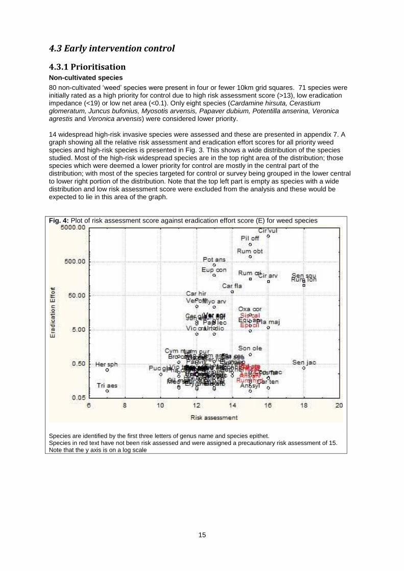
80 non-cultivated ‘weed’ species were present in four or fewer 10km grid squares. 71 species were initially rated as a high priority for control due to high risk assessment score (>13), low eradication impedance (<19) or low net area (<0.1). Only eight species (Cardamine hirsuta, Cerastium glomeratum, Juncus bufonius, Myosotis arvensis, Papaver dubium, Potentilla anserina, Veronica agrestis and Veronica arvensis) were considered lower priority. 14 widespread high-risk invasive species were assessed and these are presented in appendix 7. A graph showing all the relative risk assessment and eradication effort scores for all priority weed species and high-risk species is presented in Fig. 3. This shows a wide distribution of the species studied. Most of the high-risk widespread species are in the top right area of the distribution; those species which were deemed a lower priority for control are mostly in the central part of the distribution; with most of the species targeted for control or survey being grouped in the lower central to lower right portion of the distribution. Note that the top left part is empty as species with a wide distribution and low risk assessment score were excluded from the analysis and these would be expected to lie in this area of the graph.
Fig. 4: Plot of risk assessment score against eradication effort score (E) for weed species
Species are identified by the first three letters of genus name and species epithet. Species in red text have not been risk assessed and were assigned a precautionary risk assessment of 15. Note that the y axis is on a log scale

16
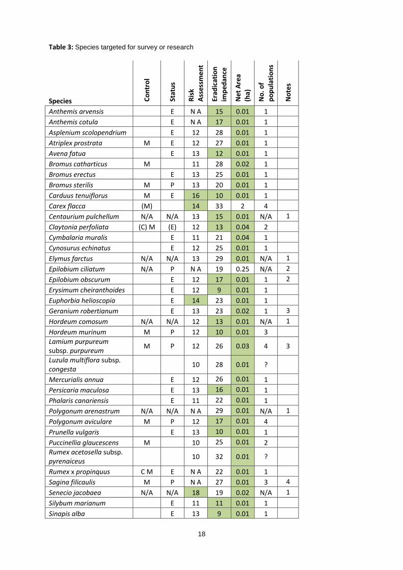
Seven taxa were removed from the list of priorities for control to the list of species for further research and survey:
Sagina filicaulis was removed from the control shortlist as it is very inconspicuous, difficult to distinguish from a very widespread species and it was considered that it was likely to be impossible to delimit the extent of infestation, which is a vital prerequisite for successful eradication (Panetta & Lawes, 2005).
Geranium robertianum, Lamium purpureum and Sonchus oleraceus were removed from the control shortlist because they are present on an island that is difficult to access (Westpoint Island). The logistics and costs of gaining access to these populations frequently enough to undertake successful eradication were outside the scope of this project.
Rumex x propinquus is a sterile spontaneous hybrid between two widespread introduced species, R. crispus and R. obtusifolius.
Luzula multiflora subsp. congesta, and Rumex acetosella subsp. pyrenaiceus are very similar to very widespread taxa. The distributions of these taxa are currently not well known, but are likely to prove to be widespread.
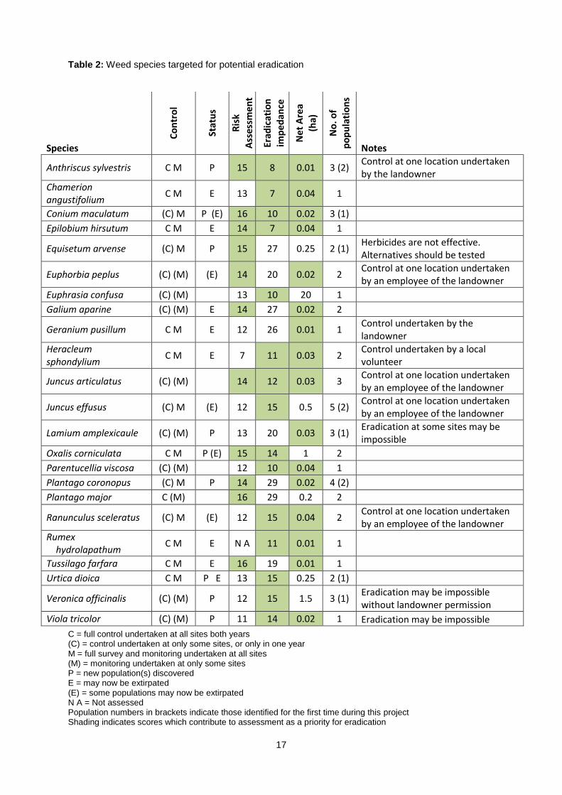
This left 23 weed species as the main targets for control and monitoring for potential eradication and 48 weed species for further survey and research. These are presented in Tables 2 and 3 respectively. Cultivated species
31 cultivated species were excluded from further analysis as they are of agricultural value as pasture species, or are known in the wild only from planted specimens in windbreaks, forests or abandoned gardens and were therefore not considered suitable for control. The remaining 60 cultivated species with naturalised populations present in four or fewer 10km grid squares were assessed. All taxa were rated as being of high priority for control of naturalised populations. 17 taxa were identified as priorities for potential future control as full geo-referenced data are available for all known populations. 43 taxa are less well known and were identified as priorities for further survey and research. These are presented in Appendix 7.
4.3.2 Control and Monitoring Control and monitoring of some or all populations was undertaken for 23 target ‘weed’ species, in either one or both years of the project, see Table 2. Of these, eight species may now be extirpated and it is expected that at least 11 more species may be extirpated if control actions are continued in coming years. With very limited data covering only one or two years’ control, it is not possible to undertake any meaningful analysis of the impacts of control. However, the baseline data and monitoring protocols which have been established do allow these impacts to be fully assessed in future. As with the protocols for C. vulgare in section 4.1.3, the resources produced by this project (including the control calendar and data recording sheet, the PDA-based data recording system and BRAHMS database) together provide the basis for ongoing control and monitoring of all populations of all target species and also allow this program to be expanded to include additional species as required. It is recommended that monitoring of each site continues at least annually for three years after the last individual is recorded at that site, after which the site can be declared extirpated, though as some species have persistent soil seedbanks, occasional monitoring should continue wherever possible.
17
Table 2: Weed species targeted for potential eradication
Species
Co
ntr
ol
Stat
us
Ris
k
Ass
essm
en
t
Erad
icat
ion
imp
edan
ce
Net
Are
a
(ha)
No
. of
po
pu
lati
on
s
Notes
Anthriscus sylvestris C M P 15 8 0.01 3 (2) Control at one location undertaken by the landowner
Chamerion angustifolium
C M E 13 7 0.04 1
Conium maculatum (C) M P (E) 16 10 0.02 3 (1)
Epilobium hirsutum C M E 14 7 0.04 1
Equisetum arvense (C) M P 15 27 0.25 2 (1) Herbicides are not effective. Alternatives should be tested
Euphorbia peplus (C) (M) (E) 14 20 0.02 2 Control at one location undertaken by an employee of the landowner
Euphrasia confusa (C) (M)
13 10 20 1
Galium aparine (C) (M) E 14 27 0.02 2
Geranium pusillum C M E 12 26 0.01 1 Control undertaken by the landowner
Heracleum sphondylium
C M E 7 11 0.03 2 Control undertaken by a local volunteer
Juncus articulatus (C) (M)
14 12 0.03 3 Control at one location undertaken by an employee of the landowner
Juncus effusus (C) M (E) 12 15 0.5 5 (2) Control at one location undertaken by an employee of the landowner
Lamium amplexicaule (C) (M) P 13 20 0.03 3 (1) Eradication at some sites may be impossible
Oxalis corniculata C M P (E) 15 14 1 2
Parentucellia viscosa (C) (M)
12 10 0.04 1
Plantago coronopus (C) M P 14 29 0.02 4 (2)
Plantago major C (M)
16 29 0.2 2
Ranunculus sceleratus (C) M (E) 12 15 0.04 2 Control at one location undertaken by an employee of the landowner
Rumex hydrolapathum
C M E N A 11 0.01 1
Tussilago farfara C M E 16 19 0.01 1
Urtica dioica C M P E 13 15 0.25 2 (1)
Veronica officinalis (C) (M) P 12 15 1.5 3 (1) Eradication may be impossible without landowner permission
Viola tricolor (C) (M) P 11 14 0.02 1 Eradication may be impossible
C = full control undertaken at all sites both years (C) = control undertaken at only some sites, or only in one year M = full survey and monitoring undertaken at all sites (M) = monitoring undertaken at only some sites P = new population(s) discovered E = may now be extirpated (E) = some populations may now be extirpated N A = Not assessed Population numbers in brackets indicate those identified for the first time during this project Shading indicates scores which contribute to assessment as a priority for eradication
18
Table 3: Species targeted for survey or research
Species Co
ntr
ol
Stat
us
Ris
k
Ass
essm
en
t
Erad
icat
ion
imp
edan
ce
Net
Are
a (h
a)
No
. of
po
pu
lati
on
s
No
tes
Anthemis arvensis
E N A 15 0.01 1 Anthemis cotula
E N A 17 0.01 1
Asplenium scolopendrium
E 12 28 0.01 1 Atriplex prostrata M E 12 27 0.01 1 Avena fatua
E 13 12 0.01 1
Bromus catharticus M
11 28 0.02 1 Bromus erectus
E 13 25 0.01 1
Bromus sterilis M P 13 20 0.01 1 Carduus tenuiflorus M E 16 10 0.01 1 Carex flacca (M)
14 33 2 4
Centaurium pulchellum N/A N/A 13 15 0.01 N/A 1
Claytonia perfoliata (C) M (E) 12 13 0.04 2
Cymbalaria muralis
E 11 21 0.04 1
Cynosurus echinatus
E 12 25 0.01 1
Elymus farctus N/A N/A 13 29 0.01 N/A 1
Epilobium ciliatum N/A P N A 19 0.25 N/A 2
Epilobium obscurum
E 12 17 0.01 1 2
Erysimum cheiranthoides
E 12 9 0.01 1
Euphorbia helioscopia
E 14 23 0.01 1
Geranium robertianum
E 13 23 0.02 1 3
Hordeum comosum N/A N/A 12 13 0.01 N/A 1
Hordeum murinum M P 12 10 0.01 3
Lamium purpureum subsp. purpureum
M P 12 26 0.03 4 3
Luzula multiflora subsp. congesta
10 28 0.01 ?
Mercurialis annua
E 12 26 0.01 1
Persicaria maculosa
E 13 16 0.01 1
Phalaris canariensis
E 11 22 0.01 1
Polygonum arenastrum N/A N/A N A 29 0.01 N/A 1
Polygonum aviculare M P 12 17 0.01 4
Prunella vulgaris
E 13 10 0.01 1
Puccinellia glaucescens M
10 25 0.01 2
Rumex acetosella subsp. pyrenaiceus
10 32 0.01 ?
Rumex x propinquus C M E N A 22 0.01 1
Sagina filicaulis M P N A 27 0.01 3 4
Senecio jacobaea N/A N/A 18 19 0.02 N/A 1
Silybum marianum
E 11 11 0.01 1
Sinapis alba
E 13 9 0.01 1
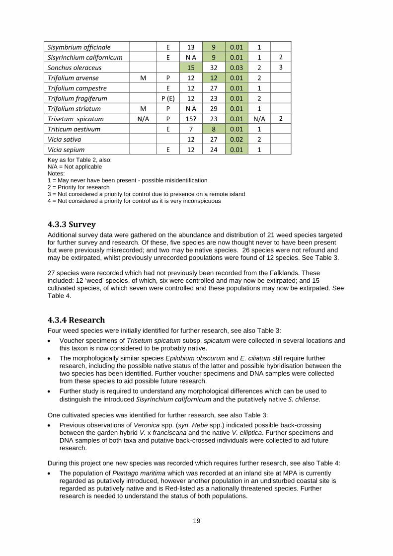
19
Sisymbrium officinale
E 13 9 0.01 1
Sisyrinchium californicum
E N A 9 0.01 1 2
Sonchus oleraceus
15 32 0.03 2 3
Trifolium arvense M P 12 12 0.01 2
Trifolium campestre
E 12 27 0.01 1
Trifolium fragiferum
P (E) 12 23 0.01 2
Trifolium striatum M P N A 29 0.01 1
Trisetum spicatum N/A P 15? 23 0.01 N/A 2
Triticum aestivum
E 7 8 0.01 1
Vicia sativa
12 27 0.02 2
Vicia sepium
E 12 24 0.01 1
Key as for Table 2, also: N/A = Not applicable Notes: 1 = May never have been present - possible misidentification 2 = Priority for research 3 = Not considered a priority for control due to presence on a remote island 4 = Not considered a priority for control as it is very inconspicuous
4.3.3 Survey Additional survey data were gathered on the abundance and distribution of 21 weed species targeted for further survey and research. Of these, five species are now thought never to have been present but were previously misrecorded; and two may be native species. 26 species were not refound and may be extirpated, whilst previously unrecorded populations were found of 12 species. See Table 3. 27 species were recorded which had not previously been recorded from the Falklands. These included: 12 ‘weed’ species, of which, six were controlled and may now be extirpated; and 15 cultivated species, of which seven were controlled and these populations may now be extirpated. See Table 4.
4.3.4 Research Four weed species were initially identified for further research, see also Table 3:
Voucher specimens of Trisetum spicatum subsp. spicatum were collected in several locations and this taxon is now considered to be probably native.
The morphologically similar species Epilobium obscurum and E. ciliatum still require further research, including the possible native status of the latter and possible hybridisation between the two species has been identified. Further voucher specimens and DNA samples were collected from these species to aid possible future research.
Further study is required to understand any morphological differences which can be used to
distinguish the introduced Sisyrinchium californicum and the putatively native S. chilense. One cultivated species was identified for further research, see also Table 3:
Previous observations of Veronica spp. (syn. Hebe spp.) indicated possible back-crossing between the garden hybrid V. x franciscana and the native V. elliptica. Further specimens and DNA samples of both taxa and putative back-crossed individuals were collected to aid future research.
During this project one new species was recorded which requires further research, see also Table 4:
The population of Plantago maritima which was recorded at an inland site at MPA is currently regarded as putatively introduced, however another population in an undisturbed coastal site is regarded as putatively native and is Red-listed as a nationally threatened species. Further research is needed to understand the status of both populations.
20
Table 4: Species recorded for the first time 2011-13
Species Co
ntr
ol
Stat
us
No
. of
po
pu
lati
on
s
Cu
ltiv
ated
in
Falk
lan
ds
Catapodium cf. rigidum C M E 1 Centaurea nigra C M E 1 Y
Cerastium tomentosum C M E 1 Y
Chenopodium album C M E 1 Cichorium intybus
1 Y
Crocus cf. vernus C M E 1 Y
Cytisus scoparius C M E 1 Y
Datura cf. stramonium C M E 1 Deschampsia cf. caespitosa M 1 Y
Erica cf. cinerea
1 Y
Erophila verna M 2 Fallopia cf. convolvulus (M) 2 Festuca filiformis
1 Y
Holcus cf. mollis
1 Y
Lupinus nootkatensis C M E 1 Y
Myosotis ramosissima (M) 1 Oxalis cf. articulata C M E 1 Y
Papaver somniferum C M E 2 Y
Plantago maritima C M E 1 Plantago media C M 1 Potentilla x mixta C M E 1 Senecio vulgaris subsp. hibernica C M E 1 Stellaria alsine (M) 3 Trifolium cf. ambiguum
1 Y
Trifolium sp.
1 Y
Trifolium striatum (M) 1 Veronica sp. M 1 Y
Key as for Table 2
21
4.4 Informing the Falkland Islands Invasive Plants Strategy The survey, risk assessment and management information gathered in this project we presented to range of key local stakeholders, in November 2012. The workshop was well attended by a range of stakeholders from several government departments, QUANGOs, NGOs and private enterprises as well as other local residents, farmers and landowners.
4.5 Enhancing local capacity 4.5.1 Training Three local field assistants and more than 10 local volunteers have been trained and participated
in invasive plant survey or control.
A local curator for the Falklands National Herbarium has been trained in both Stanley and at the RGB, Kew.
Four local conservation workers and volunteers were trained in collecting herbarium vouchers and DNA samples.
Regular advice was supplied to Department of Agriculture staff in support of the development of biosecurity protocols.
4.5.2 Invasive plant ID Information on the identification of the 12 most high-risk and widespread invasive species, targeted at a general audience including local residents and landowners/land-managers was produced and is available on the Falklands Conservation website.
4.5.3 Support for ongoing control of widespread invasive species Support, including advice, data, planning and submitting funding applications was provided to ensure a range of control actions for 10 widespread invasive species. These included:
Continuation of existing control programs for Cirsium vulgare and C. arvense in both 2011/12 and 2012/13, including expanding these programs to cover all known populations. This was achieved with funding and support from JNCC, FIG and the MPA conservation group. The FIG has made funding available to continue some of this control in 2013/14 and this funding is expected to be maintained in future years.
Continued implementation of control of Pilosella officinalis at three sites, including two Important Plant Areas on West Falkland, with funding from FIG.
Initiation of ongoing mapping and control of Cirsium vulgare, C. arevense, Pilosella officinalis, P. aurantiaca, Rumex crispus, R. longifolius, R. obtusifolius and Senecio squalidus at MPA/Mare Harbour by Interserve Defence Ltd and MPA conservation group, with funding from the MoD.
Initial control of Berberis microphylla and ribes magellanicum on Keppel Island, with funding and support from FIG, the MPA conservation group and FC volunteers. This work forms a good basis on which future follow-up control can be undertaken as part of ongoing work to control C. vulgare on this remote island. Eradication of these species from this remote Important Plant Area is likely to be achievable if control is continued for the next four years.
4.6 Publications
4.6.1 Popular articles Three articles on invasive plants were published in the Wool Press (Agriculture Department newsletter), as this has proved to be the best medium for reaching the main target audience of landowners and farmers. A fourth article has been submitted and is expected to be published in late 2013. The impacts of invasive plants were also discussed in one article on ex-situ conservation for Penguin News (local weekly newspaper).

22
Additional publicity in both local and conservation media is expected to accompany the distribution of the ID guide leaflet and the publication of the checklist.
Articles about the project have been published in the FC newsletter and magazine and information on the project is available on the FC website. A blog post on the impacts and control of Thistles has been produced for the UKOTs Blog at the RBG, Kew (www.kew.org/news/kew-blogs/ukots/spiny-threat-in-the-falklands.htm) and a further post on ex-situ conservation in the Falklands also referred to the impacts of invasive plants (www.kew.org/news/kew-blogs/ukots/falklands-unique-plants-in-safe-storage.htm).
4.6.2 Scientific publications A checklist and atlas of native and introduced species has been prepared in collaboration with Dr Rebecca Upson (RBG, Kew) who has extensively studied the native flora. This report has been submitted to the EPD and had been submitted to an open-access peer-reviewed journal.
23
5. Discussion
5.1 Cultivated plants as a source of invasive species In other countries, around 50% of all invasive plants were originally introduced for their horticultural value (Mack & Erneberg, 2002). Currently only a small proportion of species regarded as invasive in the Falklands were introduced primarily for horticultural value. Examples include Berberis microphylla, Pilosella aurantiaca and Ribes magellanicum. However, with increasing economic development and an increasing diversity of species available to gardeners across the Islands through local nurseries and mail-order seed companies, the range of species grown has probably increased significantly in recent years and is likely to continue to increase. Whilst only a small proportion of cultivated species pose a risk of becoming invasive, the increasing number of species recorded as becoming naturalised outside of cultivation indicates that this problem is likely to increase in future. Further development of the risk assessment framework for cultivated species will allow gardeners and nurseries to make informed choices to avoid the highest risk species, and to inform biosecurity policy. It may be useful to expand the current risk assessment framework to cover a wider range of species, including those not yet cultivated in the Falklands, to identify potential future risks. It may also be useful to identify and trial a range of species which are of lowest risk, including male clones of dioecious species and sterile hybrids or cultivars, which can be recommended as safe alternatives for gardeners, alongside the range of native plants currently available at the local garden centre.
5.2 Biosecurity Biosecurity is the most effective and cheapest line of defence against invasive plants. Improvements in biosecurity to prevent accidental or intentional introduction of potentially invasive species should be the highest priority. The increasing rate at which new introduced species are being recorded in the Falklands, including 27 species identified for the first time during this project, confirms this need for biosecurity as the most important area for development. Internal biosecurity actions are also potentially valuable tools to reduce the spread of species that have already arrived.
5.3 Eradication For species which are already present, the second best line of defence is surveillance and early intervention to eradicate species before they spread widely. A full understanding of which species are present and how widespread they are can inform planning an effective eradication campaign. The increasing rate at which new species are recorded indicates that many further species are already present but not yet detected, whilst the recent records of new populations of species targeted for control indicates that the distribution of many species is not well understood. Surveys for this project and other research towards the production of the checklist and atlas of the Falklands flora have led to a significant increase in our understanding of the introduced flora. However, many settlements remain unsurveyed and further survey is still required to identify all species present, and their distributions. In addition, ongoing surveillance of high risk sites such as Stanley and MPA is required to identify future arrivals at an early stage of colonisation. 159 taxa have been identified as potential targets for eradication, including 72 ‘weed’ species, 60 cultivated species and 27 species recorded for the first time during this project. Many of these are already likely to be extirpated, including a few which may have been extirpated by control actions undertaken during this project. However, it is impossible to be completely certain that a species is completely extirpated in such a short time frame as the distributions of all species are still poorly known and it is necessary to continue monitoring for several years after extirpation to ensure no plants regrow from seeds or other propagules. Continued implementation of the control protocols developed during this project is likely to lead to the eradication of most species targeted. Survey data gathered during this project allow the prioritisation process to be revisited and additional species are likely to be identified as candidates for potential eradication.
24
Some potentially invasive species are also found in cultivation and eradication of all plants is therefore unlikely to be desirable. However, control of naturalised population is likely to be beneficial, especially for populations in remote locations or areas of high biodiversity value. An ongoing, combined program to identify, survey and eradicate weed species and naturalised at an early stage of colonisation is likely to be a very cost-effective option to reduce the long-term impacts of invasive plants and should be considered a high priority for action after improvements to biosecurity. Whilst some of this work is potentially achievable by volunteers, this would still require a significant professional input to provide training, information, support and co-ordination including prioritisation and long-term oversight. This program needs to include a high degree of flexibility to cope with control of any populations of target species which may be discovered in the future, as well as the assessment and control of any new species discovered during surveys.
5.4 Control of established invasive species The last line of defence is control of species which are widely established. For many species which are already widely established, complete eradication is either undesirable or impossible and management options are likely limited to ‘do nothing’, containment, control at key sites, or biological control. This project examined three species which are widely established, Cirsium vulgare, C. arvense. and Senecio squalidus. Populations of all species are believed to be largely delimited, though some outstanding survey of islands and military instillations required. The engagement of farmers, landowners and the public is essential to ensure any additional populations are reported and can be effectively controlled. Distribution of the Invasive plant ID guide to these audiences is an important step towards this and will assist full delimitation of all 12 species described. Evidence from the baseline data suggests that previous control has led to a very significant decline in the population of C. vulgare on Saunders Island within only five years. More recently, control has been undertaken at other sites, most notably at MPA and Mare Harbour, but it is essential that this continues consistently until the aims of the control are achieved. Eradication of C. arvense is a realistic goal if sufficient capacity and funding are available consistently for at least the next five years, possibly longer. Effective, consistent control is likely to result in the eradication of small populations within three years. Thorough annual monitoring and control of the larger populations at Stanley, MPA and Mare Harbour is likely to be required for around 10 years to ensure that any recruitment from the soil seedbank is adequately addressed. Due to the higher level of seed production and shorter time from germination to seed production, eradication of C. vulgare is not a realistic medium-term goal at present. Containment is likely to be possible, preventing the establishment of new populations, but this requires significantly increased and consistent capacity and funding. Initial assessment of eradication effort suggests that this is going to be one of the most challenging species to tackle. However, the current limited distribution and development of effective monitoring and control protocols will assist management of this species; and the initial evidence form baseline surveys at Saunders Island suggests that with sufficient resources, significant reductions in abundance can be achieved within only 5 years. If all populations are subjected to such rigorous control for the next 5 years, eradication may be a possible long-term goal. Control of S. squalidus is likely to be significantly more challenging, due to the short generation time and its presence across areas of MPA with restricted access. Due to the potentially negative impacts on the health of both humans and livestock, management of this species should continue to be a significant concern. Whilst eradication is unlikely to be possible, containment may be possible with continued concerted control and surveillance for new populations.

25
6. Additional outcomes In addition to the above outcomes, the project officer was able to achieve a number of other outcomes related to native plant conservation. These were undertaken as a volunteer, making full use of his time based in the Islands. 1. Inspired and advised senior school to develop a project to establish a native plant display at
entrance to the school.
2. Advised Camp Education about school field trip to Weddell Island on monitoring invasive plants.
3. Advised/facilitated Stanley Growers converting land close to Government House to a native plant garden for use in collecting seeds/cutting for the native plant nursery.
4. Collected seeds, tillers and cuttings for propagation in the native plant nursery.
5. Collected seeds of c.50 native species for ex-situ conservation at the Millennium Seed Bank, including species not previously banked, threatened and endemic species.
6. Provided extensive statistical consultation and plant identification for habitat restoration project.
7. Provided plant identification and local logistics information for montane plant survey project.
8. Research projects developed for Imperial College students and Kew Diploma student on FI plants
9. Advised and supported the Protected Areas Officer at FC on incorporating invasive plant monitoring and control, and native plant conservation in plans for a new system of protected areas. This included presenting a workshop at a cross-territory conference on Ascension, with attendees from Ascension Island, St Helena and the Falklands.
10. Liaised with US researcher and provide samples for taxonomic research of Polystichum spp.
11. Conservation genetic study of the endangered endemic Gamochaeta antarctica and collection of genetic samples of a range of threatened native/endemic species for future conservation genetic studies.
12. Surveys of Weddell Island (Mt. Weddell plateau and Kelp Creek areas), Narrows Island, River Island, Purvis House/Warrah River, Hill Cove Horse Paddock, Middle Island, Pebble Island and other areas for native/endemic plants.
13. Discovery of at least three native plant species new to the Falklands (two possible additional species require further taxonomic study).
14. Survey and detailed recording of a range of threatened plant species and habitats, including discovery of the two largest known populations of the endangered endemic Phlebolobium maclovianum and new populations of many other globally or locally threatened species.
15. Rediscovery of the native Saxifraga magellanica, thought to be locally extinct.
26
References Broughton, D.A. & McAdam, J.H. (2002a). The vascular flora of the Falkland Islands: An
annotated Checklist and Atlas. A report to Falklands Conservation Broughton, D.A. & McAdam, J.H. (2002b). The non-native vascular flora of the Falkland
Islands. Bot. J. Scot. 54: 153-190 Convention on Biological Diversity (2002) COP 6 Decision VI/23. www.cbd.int/decisions/default.aspx Falklands Conservation website http://www.falklandsconservation.com/wildlife/plants Falkland Islands Government (2008) Falkland Islands Biodiversity Strategy 2008-2018.
www.epd.gov.fk/wp-content/uploads/BiodiversityStrategy09.pdf Hamilton, M.A. (2008). Herbarium specimen and Field Data Collection – Recommendations for
an Approach to Plant Conservation including Equipment and Supplies Needed. Report to RGB, Kew.
Hartikainen, M. (2009) South Atlantic Invasive Species Project Risk Assessment. Report to RSPB Mack, R. & Erneberg, M. (2002) The United States Naturalized Flora: Largely the Product of
Deliberate Introductions. www.jstor.org/stable/3298562 Panetta, F. D., & Lawes, R. (2005). Evaluation of weed eradication programs: the delimitation of
extent. Diversity and Distributions, 11(5), 435-442.
Panetta, F. D., Cacho, O., Hester, S., Sims‐Chilton, N., & Brooks, S. (2011). Estimating and influencing the duration of weed eradication programmes. Journal of Applied Ecology, 48(4), 980-988.
Panetta, F. D., & Timmins, S. M. (2004). Evaluating the feasibility of eradication for terrestrial weed
incursions. Plant Protection Quarterly, 19(1), 5-11. Rejmánek, M., & M. J. Pitcairn. (2002) When is eradication of exotic pest plants a realistic goal.
Turning the tide: the eradication of invasive species: 249-253. http://www.issg.org/database/species/reference_files/onoaca/rejmanek.pdf
UKOTs Blog, RBG, Kew www.kew.org/news/kew-blogs/ukots Whitehead, J. (2008). Priorities for Control: A Risk Assessment of Introduced Species on the Falkland
Islands. Report to RSPB.