introductions to heritage assets - prehistoric and romano ... · prehistoric and romano-british...
TRANSCRIPT

Prehistoric and Romano-British Settlements with Structures
On 1st April 2015 the Historic Buildings and Monuments Commission for England changed its common name from English Heritage to Historic England. We are now re-branding all our documents. Although this document refers to English Heritage, it is still the Commission's current advice and guidance and will in due course be re-branded as Historic England.
Please see our website for up to date contact information, and further
advice.
We welcome feedback to help improve this document, which will be periodically revised. Please email comments to [email protected]
We are the government's expert advisory service for England's historic environment. We give constructive advice to local authorities, owners and the public. We champion historic places helping people to understand, value and care for them, now and for the future.
HistoricEngland.org.uk/advice

Introductions to Heritage Assets
Prehistoric and Romano-British Settlements with Structures
May 2011

2Introductions to Heritage AssetsEnglish Heritage Prehistoric and Romano-British Settlements with Structures
Fig. 1. Glastonbury Lake Village work commenced in 1892 and extended until 1907. Excavation showed that this lake village, dating to the middle centuries of the 1st millennium BC, consisted of about 80 individual circular timber buildings built on top of a massive platform composed of timber and brushwood.
INTRODUCTIONThe remains of prehistoric and Romano-British settlements such as hillforts, timber or stone embanked enclosures and other, open sites (that is, not enclosed by banks or ditches) are commonly observed in all parts of England. Those pre-medieval settlement sites that incorporate, or comprise, separate and identifiable structural components are altogether rarer. This asset description will, therefore, focus on a limited number of site types where it is possible to observe different forms of enclosure boundary as well as related structures such as houses and ancillary buildings. The description will assess courtyard houses, stone hut circles, unenclosed stone hut circle settlements, as well as wetland settlements.
These sorts of sites are usually found in specific geographical niches, either where building materials such as stone are readily available - predominantly upland areas in England - or where preservation is exceptional, such as waterlogged environments along the coast or in river valleys. The geographical scope is matched by the chronological range and these forms of settlement sites have a very long currency indeed: it may well be, for instance, that sites in wetland locations were being constructed in the middle of the 4th millennium BC.
HISTORY OF RESEARCHImportant, and early, contributions were made by the Devon Exploration Committee which was formally established in 1894. Its work assessed a number of settlement and house sites on Dartmoor and was influential in that, as well as carrying out survey and undertaking excavation, they reconstructed a number of buildings. Elsewhere, important fieldwork was undertaken during the second half of the 19th century, particularly on the upland moors of northern England. Work in the Peak District by Thomas Bateman and Samuel Carrington, for instance, focussed on a range of stone-built structures including cairns and settlements. Similarly, George Tate and Henry MacLauchlan undertook detailed investigation, including excavation, at a number of locations in Northumberland. Research into Somerset’s wetland sites was broadly co-eval; work at Glastonbury Lake Village was initiated in 1892 (Figure 1), and investigations at Meare in 1910. Important work on stone-built settlements and related forms has been carried out most notably at Stannon Down (Cornwall), Nornour (Isles of Scilly) and Standrop Rigg (Northumberland). In recent years,
survey work on Dartmoor, Bodmin Moor and the Cheviots by English Heritage has elucidated the complexity and sequence observed at a number of sites in these upland settings.
DESCRIPTIONWetland SettlementsWetland settlements, due to the exceptional preservation of organic matter, provide massive amounts of information about the lives of past communities as well as the contemporary environment. These sorts of sites, when excavated, often produce abundant artefactual evidence for a range of materials rarely or never recovered from dryland sites including wooden objects and basketry, with metalwork and ceramics also very well preserved. Studies of insects, pollen and other environmental data from these sites have shown not only the nature of the environmental setting of these settlements but also evidence concerning living conditions and economy.

3Prehistoric and Romano-British Settlements with StructuresIntroductions to Heritage AssetsEnglish Heritage
Fig. 2. Recent re-excavation of one of the timber platforms as Glastonbury, Somerset, highlighted not only the incredible levels of preservation at the site, but also the threats to it from desiccation in a landscape rapidly drying out.
Fig. 3. This aerial photograph shows the complex layout of the courtyard settlement at Chysauster, Cornwall. At least ten houses have been recorded articulated along a central street and surrounded by a contemporary field system. The village was built in the final centuries of the 1st millennium BC but was certainly still occupied in the 2nd century AD.
One of the significant features of these settlements are the materials used as foundations. These vary from midden (that is rubbish) deposits, to clay, brushwood and re-used timber, and may be laid directly on blanket bog as at Meare, or be built up into artificial platforms as at Glastonbury (Figure 2). The exceptional preservation also provides valuable evidence of building techniques and wood working which cannot be gained from dry sites. The dendrochronological research potential is also high.
The forms of settlement encountered are, however, similar to those from dry land. Small enclosed settlements consisting of one to three houses are known, for instance, Ballacagan, Lough (Isle of Man) and Cold Ash (Berkshire), while Glastonbury provides an example of an enclosed settlement. East and West Meare are unenclosed settlements with evidence of seasonal occupation suggesting trading at tribal boundaries on non-agricultural land, possibly perceived as neutral ground.
These types of asset are very rare with examples only known at present from four locations in England: the Somerset Levels, the Kennet Valley, the Cambridgeshire Fens, and the Isle of Man. Waterlogged wooden trackways have been found more frequently, and it may well be that many are closely associated with this type of settlement providing routes to dry land or to other locations within the wetland.
Waterlogged prehistoric settlements are highly at risk from any actions that lower the water table (for instance, drainage works, tree planting) since once above the permanent water-table oxidising conditions become established leading to rapid decay of organic remains. Peat extraction will also destroy any sites within the deposits being exploited. The lack of visibility of these sites, which are often only present as slight mounds within the landscape, means that they are recurrently overlooked.
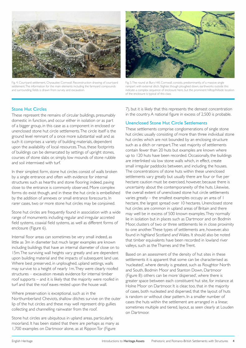
Courtyard HousesCourtyard houses and their settlements consist, predominantly, of a small oval or sub-circular compound with a maximum overall diameter of 30m defined by a strong, thick, wall. This wall, normally composed of earth and rubble and revetted in locally quarried stone, stands to a height of about 1.5m and is punctured by a single entrance passageway which leads to an
interior open area, or courtyard (Figure 3). Grouped around this, at the rear of the courtyard and against the inner face of the enclosure wall, there are usually a number of conjoined rooms or cells. This arrangement is dominated by one large circular or oval room, often set directly opposite the entrance to the compound, and this has a maximum diameter or width of 10m: it is frequently observed that this room is flanked to one side by an elongated, narrower, cell. Excavation, at places such as Carn Euny or Chysauster (Cornwall), has shown that the round or oval rooms served as domestic areas and it has been suggested that the elongated rooms functioned as animal byres or storage areas. Other contiguous, smaller, ancillary cells were also constructed and these, too, were in all likelihood used as storage areas or animal penning (Figure 4). Again, excavation reveals that although the internal structures would have been roofed, probably with turf, the settlement compound itself, would have remained open to the elements.
Courtyard houses of this type are confined, geographically, to a very small area indeed, clustering on the West Penwith peninsula at the furthest western extent of Cornwall as well as the Isles of Scilly. There are strong morphological and chronological links, however, with a range of domestic structures seen in northern Britain, including scooped settlements and homesteads recorded in the Northumberland Cheviots and dun-related settlements and wheelhouses in the Western Isles. Courtyard houses are often grouped together in small clusters and are frequently associated with stone-built roundhouses and although the majority of courtyard house settlements are unenclosed, a smaller number are sometimes located within the boundaries of other larger enclosures called rounds (Figure 5).
Courtyard houses settlements are few in number – there may well be under 50 known examples – and are often characterised as being small-scale farms but the contrast in scale with other, contemporary, forms of settlement is clear. They are more monumentally constructed but, paradoxically, contain space for perhaps only one family. It may well be that this group occupied an elevated status in the social system. Nonetheless, fieldwork repeatedly shows courtyard house settlements in close co-location with contemporary irregular accreted field systems.
Introductions to Heritage AssetsEnglish Heritage 4Prehistoric and Romano-British Settlements with Structures
Fig. 4. Courtyard settlement, Chysauster, Cornwall. Reconstruction drawing of courtyard settlement. The information for the main elements including the farmyard compounds and surrounding fields is drawn from survey and excavation.
Fig. 5. The round at Bury Hill, Cornwall, consists, predominantly, of a massive single rampart with external ditch. Slighter, though ploughed down, earthworks outside this indicate a complex sequence of enclosure here, but the prominent hilltop/hillside location of the enclosure is typical of this class.
Stone Hut CirclesThese represent the remains of circular buildings, presumably domestic in function, and occur either in isolation or as part of a bigger group, in this case as a component in enclosed or unenclosed stone hut circle settlements. The circle itself is the ground level remnant of a once more substantial wall and as such it comprises a variety of building materials, dependent upon the availability of local resources. Thus, these footprints of buildings can be demarcated by settings of upright stones, courses of stone slabs or, simply, low mounds of stone rubble and soil intermixed with turf.
In their simplest form, stone hut circles consist of walls broken by a single entrance and often with evidence for internal structures such as hearths and stone flooring: indeed, paving close to the entrance is commonly observed. More complex forms do exist though, and in these the hut circle is embellished by the addition of annexes or small entrance forecourts. In rarer cases, two or more stone hut circles may be conjoined.
Stone hut circles are frequently found in association with a wide range of monuments including regular and irregular accreted field systems, coaxial field systems, as well as different forms of enclosure (Figure 6).
Internal floor areas can sometimes be very small indeed, as little as 3m in diameter but much larger examples are known including buildings that have an internal diameter of close on to 15m. The surviving wall heights vary greatly and are dependent upon building material and the impacts of subsequent land use. Where best preserved, in unploughed, upland settings, walls may survive to a height of nearly 1m. They were clearly roofed structures – excavation reveals evidence for internal timber roof supports – and it is likely that the majority were roofed in turf and that the roof eaves rested upon the house wall.
Where preservation is exceptional, such as in the Northumberland Cheviots, shallow ditches survive on the outer lip of the hut circles and these may well represent drip gullies collecting and channelling rainwater from the roof.
Stone hut circles are ubiquitous in upland areas, particularly, moorland. It has been stated that there are perhaps as many as 1,700 examples on Dartmoor alone, as at Rippon Tor (Figure
7), but it is likely that this represents the densest concentration in the country. A national figure in excess of 2,500 is probable.
Unenclosed Stone Hut Circle SettlementsThese settlements comprise conglomerations of single stone hut circles: usually consisting of more than three individual stone hut circles which are not bounded by an enclosing structure such as a ditch or rampart. The vast majority of settlements contain fewer than 20 huts but examples are known where up to 120 huts have been recorded. Occasionally, the buildings are interlinked via low stone walls which, in effect, create small irregular paddocks between, and including, the houses. The concentrations of stone huts within these unenclosed settlements vary greatly but usually there are four or five per hectare: caution must be exercised, however, because there is uncertainty about the contemporaneity of the huts. Likewise, the overall extent of unenclosed stone hut circle settlements varies greatly – the smallest examples occupy an area of 1 hectare, the largest spread over 10 hectares. Unenclosed stone hut circles are common in upland areas of Britain and there may well be in excess of 500 known examples. They normally lie in isolation but in places such as Dartmoor and on Bodmin Moor, clusters of two or three settlements lie in close proximity to one another. These types of settlements are, however, also found in highland Scotland and Wales. It should also be noted that timber equivalents have been recorded in lowland river valleys, such as the Thames and the Trent.
Based on an assessment of the density of hut sites in these settlements it is apparent that some can be characterised as ‘nucleated’, where density is greatest, such as Roughtor North and South, Bodmin Moor and Stanton Down, Dartmoor (Figure 8): others can be more ‘dispersed’, where there is greater space between each constituent hut site, for instance at Holne Moor on Dartmoor. It is clear, too, that in the majority of cases, both nucleated and dispersed, that the layout of huts is random or without clear pattern. In a smaller number of cases the huts within the settlement are arranged in a linear, sometimes multiple and tiered, layout, as seen clearly at Louden on Dartmoor.

Introductions to Heritage AssetsEnglish Heritage 5Prehistoric and Romano-British Settlements with Structures
Fig. 6. Settlement and field system at Leskernick, Cornwall. The walls of an irregular ac-creted field system show clearly on the aerial photograph, as do the cluster of stone hut circles. Those at ‘A’ on the photograph consist of low circular walls with entrance porches; others are less well defined such as the dispersed cluster of huts at ‘B’.
Fig. 7. Settlement, Rippon Tor, Dartmoor, Devon. Single stone hut and fields. The interlock-ing of the settlement and its fields is shown clearly in this basic field survey. The close proximity of a fresh water supply is notable too, and is a pattern repeated at a large number of contemporary sites.
These are domestic sites but it is not evident, on the basis of fieldwork, if all sites were residential in nature or if some were used for storage or as animal shelters.
Unenclosed stone hut circle settlements do occur in close proximity to prehistoric enclosures, notably in upland areas such as Dartmoor and Bodmin Moor. Close associations are also evident with different forms of field system including cairnfields, coaxial, regular and irregular accreted types.
CHRONOLOGYThe majority of wetland settlement sites that have been dated belong to the period between 1500 BC and the Roman Conquest of AD43. Undoubtedly, earlier wetland settlement sites will be found and the date of 3806/7 BC for a wooden track in the Somerset Levels perhaps indicated the presence of a nearby, contemporary, settlement.
Evidence from excavation at a number of sites, principally on Dartmoor, indicates that stone hut circles were being built and occupied from the middle of the 2nd millennium BC, but the form has a very long currency indeed and examples were still being built in the early 1st millennium AD. Others were re-used in more recent times as shieling sites, for example.
Evidence from excavations at places such as Nornour (Isles of Scilly) and St Eval (Cornwall), suggests that the earliest unenclosed stone hut circle settlements were being constructed by the middle of the 2nd millennium BC but others were certainly being built and occupied well into the 1st millennium AD. There are indications from excavation, however, that timber structures preceded the stone variants, although the precise date of these earlier features is unclear.
The chronology of courtyard houses is complex but there is a clear horizon of construction and use that spans the 2nd to 4th centuries AD. It is apparent that a number developed directly from Late Iron Age roundhouse settlements, and in these instances the roundhouses were incorporated as rooms into the new layout.
FURTHER READINGThe work at Glastonbury and Meare lake villages was published by Arthur Bulleid and George Gray in 1911 and 1948 respectively, and the significance of this work has seen recent review by John Coles and Steve Minnitt, Industrious and Fairly Civilized: Glastonbury Lake Village (1995). John Coles and Bryony Coles, Sweet Track to Glastonbury: Somerset Levels in Prehistory (1986) is a good general account of the wetlands of the Somerset Levels.
A comprehensive discussion of the prehistoric settlements with structures is outlined in Barry Cunliffe, Iron Age Communities in Britain (2005 edn). Accessible and generalised assessments of courtyard houses, stone hut circles and unenclosed stone hut circle settlements can be found at http://www.historic-cornwall.org.uk/flyingpast/. More detailed analyses are contained within reports on the survey work on Bodmin Moor: Nicholas Johnson and Peter Rose, Bodmin Moor. An Archaeological Survey (1994). Peter Topping, ‘Landscape Narratives: the South East Cheviots Project’, Proceedings of the Prehistoric Society 74 (2008), 323-64, discusses prehistoric settlement forms close to the Anglo-Scottish border.

Introductions to Heritage AssetsEnglish Heritage 6Prehistoric and Romano-British Settlements with Structures
Fig. 8. Bodmin Moor, Cornwall. Landscape of fields and settlement. The landscape around the tor enclosure at Roughtor is dominated by clusters of stone built huts, either individually or within small clusters. Contemporary fields and trackways are visible too.
CREDITSAuthor: Pete Topping
Cover: Reconstructed Iron Age roundhouse, Avalon Marshes Centre, Somerset (© Dave McOmish).
Figure 1: © NMR English Heritage.Figure 2: © Somerset County CouncilFigures 3, 5: © Cornwall Historic Environment Service Figures 4, 8: © English HeritageFigure 6: © RCHMEFigure 7: © Aileen Fox
If you would like this document in a different format, please contact our Customer Services department:
Telephone: 0870 333 1181
Fax: 01793 414926
Textphone: 01793 414878
E-mail: [email protected]