introduction to hydrology and the water balance · pdf fileintroduction to hydrology and the...
TRANSCRIPT

Introduction to hydrology and the water balance

The science of hydrologyThe science that describes and predicts the occurrence, circulation
and distribution of the earth’s water. There are two principal foci:• The global hydrologic cycle: Transfers of water between the land,
ocean and atmosphere • The land phase of the hydrologic cycle: The movement of water
on and under the land surface, physical and chemical interactions with earth materials accompanying that movement, and the biological processes that conduct of affect that movement.
Q: Why study hydrology?A: Human systems are intimately shaped by the availability, flows
and quality of water.• Agriculture• Manufacturing• Mining• Recreation

The science of hydrology (cont.)
Dingman 2002, Figure 1-4
The figure at left shows the position of hydrologic science in the spectrum of basic sciences to water resource management. Hydrology is an interdisciplinary geoscience built upon the basic sciences of mathematics, statistics physics, chemistry and biology.

Space and time scales of hydrologic processes
Dingman 2002, Figure 1-3
Hydrologic processes encompass a suite of space and time scales; from thunderstorms that occur over the course of minutes to hours and space scales of a few kilometers or less to the development of major river basins taking place over millions to tens of millions of years and space scales of 1000-10,000 km.

IPCC-AR4
The challenge of water resource management in Colorado and the west brings home the importance of hydrology as a field of research and as a vocation. Most of the precipitation in Colorado and the west falls in the mountains and must be diverted to where it is needed for agriculture and other uses.
Water in the west
There is strong consensus from different climate models that the westwill become warmer, affecting the winter snowpack that drives water management strategies. It may become drier as well. Can we meet these challenges?
Office of the State Engineer, Colorado

Boulder Colorado water supply The City of Boulder receives its raw water supply from:
Barker Reservoir -- 40% of the city's annual water supplySilver Lake Watershed -- 40% of the city's annual water supply Boulder Reservoir -- 20% of the city's annual water supplyOn any given day, the city may be taking its water supply from any one of these sources or even all three.
Barker ReservoirThe Barker System was originally constructed as a hydroelectric power generation system by the Colorado Power Company. It was later purchased by Public Service Company of Colorado, now known as Xcel Energy. The system, consisting of the Boulder Canyon Hydroelectric Project, Barker and Kossler reservoirs and the connecting pipelines were purchased by the City of Boulder in March 2001. Silver Lake WatershedThe city-owned Silver Lake Watershed is located on North Boulder Creek east of the Continental Divide. Seven reservoirs are located in the Watershed. These reservoirs store water during high streamflowperiods. Water is then released during low streamflow periods to meet the water needs of Boulder. Boulder ReservoirThe Boulder Reservoir, located northeast of Boulder, receives water from the Colorado River through the Colorado-Big Thompson (CBT) system and the Windy Gap Project. Boulder's share of these projects is delivered through facilities operated by the Northern Colorado Water Conservancy District (NCWCD). Reservoirs, located on tributaries of the upper Colorado River on the western slope of the Rocky Mountains, collect the water. The water is then delivered to the eastern slope where is treated for municipal use at the Boulder Reservoir Water Treatment Plant.
http://www.bouldercolorado.gov

Colorado-Big Thompson project
The C-BT is the largest transmountain water diversion project in Colorado. The water is used to help irrigate approximately 693,000 acres of northeastern Colorado farmland. Twelve reservoirs, 35 miles of tunnels, 95 miles of canals and 700 miles of transmission lines comprise the complex collection, distribution and power system.
West of the Continental Divide, Willow Creek and Shadow Mountain reservoirs, Grand Lake and Lake Granby collect and store the water of the upper Colorado River. The water is pumped into Shadow Mountain Reservoir where it flows by gravity into Grand Lake. From there, the 13.1 mile Alva B. Adams Tunnel transports the water under the divide to the East Slope.
Once the water reaches the East Slope, it is used to generate electricity as it falls almost half a mile through five power plants on its way to Colorado's Front Range. Carter Lake, Horsetooth Reservoir and Boulder Reservoir store the water. C-BT water is released as needed to supplement native water supplies in the South Platte River basin.
http://www.ncwcd.org/project_features/cbt_main.asp

Colorado-Big Thompson project
http://www.ncwcd.org/project_features/cbt_maps.asp

Alva B. Adams tunnel
http://www.ncwcd.org/project_features/East_Portal1.asp
East portal of the tunnel
Excavation crews spent four years, from 1940-1944, drilling the tunnel. The first water flowed east in 1947. The tunnel is named for a U.S. senator from Colorado who played a key role in convincing Congress to fund and construct the Colorado-Big Thompson Project. The Adams Tunnel is the longest in the United States to provide water for irrigation. The tunnel is maintained by the U.S. Bureau of Reclamation.
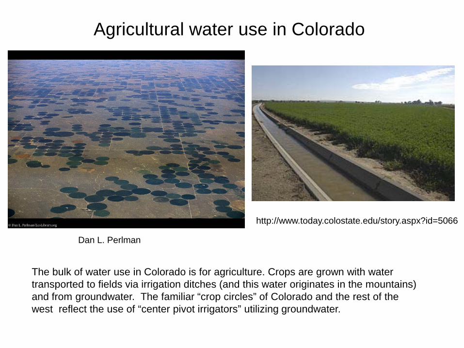
Agricultural water use in Colorado
http://www.today.colostate.edu/story.aspx?id=5066
Dan L. Perlman
The bulk of water use in Colorado is for agriculture. Crops are grown with water transported to fields via irrigation ditches (and this water originates in the mountains) and from groundwater. The familiar “crop circles” of Colorado and the rest of the west reflect the use of “center pivot irrigators” utilizing groundwater.

Western water law: A complex issue
Water law in the west is a complex system of “prior appropriation”. The two major concepts are: 1) a water right is a right to the use of the water; the right is acquired by appropriation; and 2) an appropriation is the act of diverting water from its source and applying it to a beneficial use.
Under appropriation doctrine, the oldest rights prevail. The earliest water users have priority over later appropriators during times of water shortage. Public waters are to be used for a useful or beneficial purpose. The appropriator can use only the amount of water presently needed, allowing excess water to remain in the stream. Once the water has served its beneficial use, any waste or return flow must be returned to the stream.
http://www.waterinfo.org/rights.html
http://www.crwcd.org/page_147
http://cechpress.com/Current_Projects.html
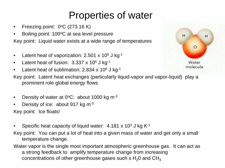
Properties of water• Freezing point: 0oC (273.16 K)• Boiling point: 100oC at sea level pressureKey point: Liquid water exists at a wide range of temperatures
• Latent heat of vaporization: 2.501 x 10⁶ J kg-1
• Latent heat of fusion: 3.337 x 10⁵ J kg-1
• Latent heat of sublimation: 2.834 x 10⁶ J kg-1
Key point: Latent heat exchanges (particularly liquid-vapor and vapor-liquid) play a prominent role global energy flows
• Density of water at 0oC: about 1000 kg m-3
• Density of ice: about 917 kg m-3
Key point: Ice floats!
• Specific heat capacity of liquid water: 4.181 x 10³ J kg K-1
Key point: You can put a lot of heat into a given mass of water and get only a small temperature change.
Water vapor is the single most important atmospheric greenhouse gas. It can act as a strong feedback to amplify temperature change from increasing concentrations of other greenhouse gases such s H20 and CH4
Properties of water (cont)
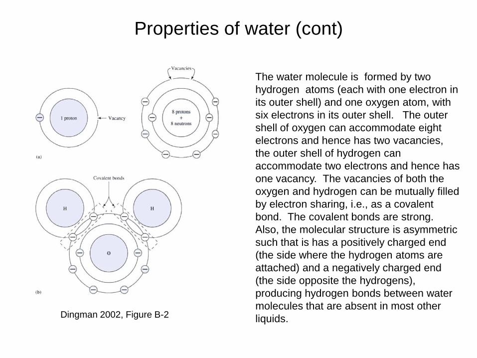
The water molecule is formed by two hydrogen atoms (each with one electron in its outer shell) and one oxygen atom, with six electrons in its outer shell. The outer shell of oxygen can accommodate eight electrons and hence has two vacancies, the outer shell of hydrogen can accommodate two electrons and hence has one vacancy. The vacancies of both the oxygen and hydrogen can be mutually filled by electron sharing, i.e., as a covalent bond. The covalent bonds are strong. Also, the molecular structure is asymmetric such that is has a positively charged end (the side where the hydrogen atoms are attached) and a negatively charged end (the side opposite the hydrogens), producing hydrogen bonds between water molecules that are absent in most other liquids. Dingman 2002, Figure B-2

Properties of water (cont.)
http://en.wikipedia.org/wiki/Hydrogen_bond
Two water molecules can form a hydrogen bond between them; the simple case when only two molecules are present, is called the water dimer. When more molecules are present, more bonds are possible because the oxygen of one water molecule has two lone pairs of electrons, each of which can form a hydrogen bond with a hydrogen on another water molecule. This can repeat such that every water molecule is H-bonded with up to four other molecules. Hydrogen bonding strongly affects the hexagonal crystal structure of ice. The high boiling point of water is due to the high number of hydrogen bonds each molecule can form relative to its low molecular mass. Due to the difficulty of breaking these bonds, water has a high boiling point, melting point, and viscosity compared to otherwise similar liquids not conjoined by hydrogen bonds.

Water phase diagram
At the range of temperature and pressures found on earth, water can be found in all three phases, solid liquid and vapor. The figure at right shows the water phase diagram with conditions on earth and other planets plotted according to their mean surface temperature and pressure (1 atm is a pressure of one earth atmosphere at sea level). The lines separating the ice, water and vapor regions of the phase diagram represent equilibrium states; e.g., at the line separating liquid water and water vapor, either state exists with equal preference. At the triple point all three phases exist in equilibrium. Dingman 2002, Figure B-1

Temperature versus density plot for fresh water and ice at standard atmospheric pressure [from Maykut, 1985, by permission of Applied Physics Laboratory, University of Washington, Seattle, WA]. Water density increases with decreasing temperature until 3.98 deg. C. With further cooling, density decreases. Hence as a fresh water column cools from the surface, it initially sets up convection (overturning). One the entire column is at the temperature of maximum density, further cooling leads to a stable (stratified) situation (with the colder, lighter water at the top), and ice can form.

Water as a universal solvent
Water is called a universal solvent because is dissolves more substances (solutes) than any other liquid. This is because it is a polar molecule, such that it easily attracts other substances that have a polar structure. The water molecules surround the charged solute; positive hydrogens close to negative charges and negative oxygens close to positive charges on the solute molecule. This interaction suspends the solute molecule in a sea of water molecules and it disperses and dissolves easily. Hence, wherever water goes, it takes along dissolved substances.
http://www.brooklyn.cuny.edu/bc/ahp/SDPS/SD.PS.water.html

The water balance and principle of conservation
Conservation: inputs (I) –outputs (O) = change in storage (S)
I – O = ∆S
• Strictly refers to a control volume, but often applied to a geographic region, most commonly a watershed
• Conservation also applies to energy and momentum.
∆SI 0
commons.wikimedia.org
control volume
watershed

The water balance of a watershedInputs (I), outputs (O) and storage (S):I: Precipitation (P)
Groundwater in (Gin)O: Evapotranspiration (ET)
Groundwater out (Gout)River discharge (Q)
Storage (S): In groundwater, rivers and lakes
∆S = P + Gin – (Q + ET + Gout)
If we assume that Gin and Gout are negligible, and that for the long-term annual mean, ∆S is zero, then:
P = ET + Q, or ET = P - Q
Dingman 2002, Fig. 2-3What can we usually measure?
P: rain gaugesQ: stream gaugesET: hard to get except local valuesGin: hard to get, assume zeroGout: hard to get, assume zeroS: often hard to get

Dimensions and Units
Length = L (meters)Volume = V V = L3 , typically m-3 or km-3
Mass = m (kilograms)Density (ρ) is often assumed to be constant for liquid water (1000
kg m-3) hence water mass m = ρ V (this means that conservation of mass equals conservation of volume)
Inputs (I) and outputs (O) are often expressed as rates of fluxes, or volume/time (e.g., m-3 s-1); storage changes must have the same units.
Inputs, outputs and storage changes can also be expressed as a change in water depth (m) averaged over the watershed. Simply divide by the area of the watershed (m-3 s-1 / m2 = m s-1). In this case, instead of discharge Q we speak of runoff R.

A few unit conversions
One still commonly sees English units in hydrology. One may have to convert units:
1 m = 39.36 inches = 3.28 feet1 m3s-1 = 35.29 f3s-1
m3s-1 is often stated as cmsf3s-1 is often stated as cfs

A few other important concepts
Residence time (TR, units of time), also called turnover time, how long on average does a given water “parcel” remain in storage.
RT= S/I = S/O (assumes that I=O, that is, steady state)Units: S= m3, I or O = m3 s-1, hence TR= 1/s-1 = sAssumes we can accurately measure S
Runoff ratio (P/R): fraction of precipitation that appears as runoff. Again use long term annual means for P and R,
• Low runoff ratio: Water loss from ET is big• High runoff ratio: Water loss from ET is small

Some local numbersMiddle Boulder Creek: 06725500 (Nederland)
Average Q = 54.4 cfs (ft3 s-1)= 1.54 cms (m3 s-1)= 4.86x10⁷ m3 yr-1
Drainage area = 36.2 mi2
= 93.8 km2
= 9.38x10⁷ m2
R = 4.86x10⁷ m3 yr-1/9.38x107 m2 = 52 cm yr-1
Boulder Creek at Orodell: 06727000
Average Q = 86.1 cfs (ft3 s-1)= 2.43 cms (m3 s-1)= 7.7x10⁷ m3 yr-1
Drainage area = 102 mi2
= 264 km2
= 2.64x10⁸ m2
R = 7.7x10⁷ m3 yr-1/2.64x108 m2 = 29 cm yr-1
Annual Precipitation (P)Berthoud Pass: 95 cmNiwot Ridge: 93 cmGross Reservoir 53 cm City of Boulder: 48 cm (19 in)
Courtesy USGS