instrument set, reconnaissance and surveying …armyengineer.com/ohanian aea final.pdfperform...
TRANSCRIPT

“The view and opinions contained in this report are those ofthe authors(s) and should not be construed as an officialDepartment of the Army position, policy or decision, unlessso designated by other official documentation.”
UNCLASSIFIED / FOUO
Presented by:
George H. OhanianProduct Director Combat Terrain Information Systems (PD CTIS)
INSTRUMENT SET, RECONNAISSANCE AND SURVEYING (COMMON NAME: ENFIRE)
1
GLOBAL POSITION SYSTEM – SURVEY (GPS-S)
Topics To Cover
• Organization
• ENFIRE
• GPS-S
• Successes
• Challenges
• Things to Consider
• Summary

Conv
erge
nce
Depe
nden
ce
Setting the Stage
Use
r Acc
epta
nce/
Appl
icat
ion
Mod
erni
zatio
n
1400 BC
1700 1800 1950 1980 1990 2000 2020 Future
AI/ML
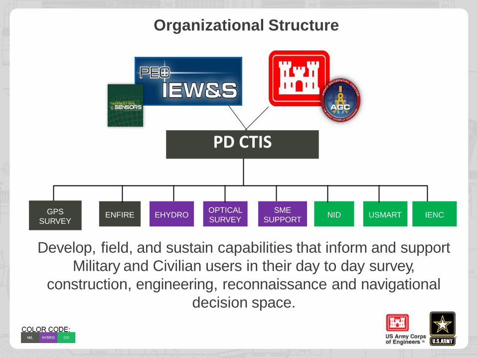
Organizational Structure
Develop, field, and sustain capabilities that inform and supportMilitary and Civilian users in their day to day survey,
construction, engineering, reconnaissance and navigational decision space.
GPS SURVEY
ENFIRE IENCNID USMARTOPTICAL SURVEYEHYDRO SME
SUPPORT
PD CTIS
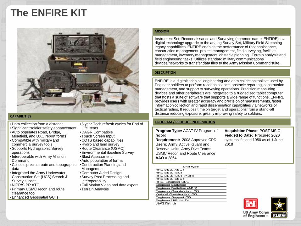
The ENFIRE KIT
5
•Data collection from a distance•Significant soldier safety enhancement•Auto populates Road, Bridge, Minefield, and UXO report forms
•Compatible with military and commercial survey tools
•Supports Hydrographic Survey operations
•Interoperable with Army Mission Command
•Collects precise route and topographic data
•Integrated the Army Underwater Construction Set (UCS) Search & Survey subset
•NIPR/SIPR ATO•Primary USMC recon and route clearance tool
•Enhanced Geospatial GUI’s
•5 year Tech refresh cycles for End of Life Items
•DAGR Compatible•Touch Screen Input•COTS based capabilities•Hydro and land survey•Route Clearance (USMC)•Environmental Baseline Survey•Blast Assessment•Auto population of forms•Construction Planning and Management
•Computer Aided Design•Survey Post Processing and interoperability
•Full Motion Video and data export•Terrain Analysis
Instrument Set, Reconnaissance and Surveying (common name: ENFIRE) is a digital technology upgrade to the analog Survey Set, Military Field Sketching legacy capabilities. ENFIRE enables the performance of reconnaissance, construction management, project management, field surveying, facilities management, inventory management, obstacle planning , Terrain analysis and field engineering tasks. Utilizes standard military communications devices/networks to transfer data files to the Army Mission Command suite.
Program Type: ACAT IV Program of recordRequirement: 2008 Approved CPDUsers: Army, Active, Guard and Reserve Units, Army Dive Teams, USMC Recon and Route Clearance AAO = 2864
Acquisition Phase: POST MS CFielded to Date: Procured 2020 systems; fielded 1950 as of 1 June 2018
CAPABILITIES
MISSION
ENFIRE is a digital technical engineering and data collection tool set used by Engineer soldiers to perform reconnaissance, obstacle reporting, construction management, and support to surveying operations. Precision measuring devices and other peripherals are integrated to a ruggedized tablet computer that hosts a suite of software that supports a wide range of functions. ENFIRE provides users with greater accuracy and precision of measurements, faster information collection and rapid dissemination capabilities via networks or tactical radios. It reduces time on target and operations from a stand-off distance reducing exposure; greatly improving safety to soldiers.
DESCRIPTION
PROGRAM / PRODUCT INFORMATION
Unit type HHC BEB, ABCTHHC BEB, IBCTHHC BEB, IBCT (ABN)HHC BEB, SBCTHHC, Engineer BDEEngineer BattalionEngineer Battalion (ABN)Engineer Construction COVertical Construction COEngineer Support COEngineer Utilities Det
USACE Districts
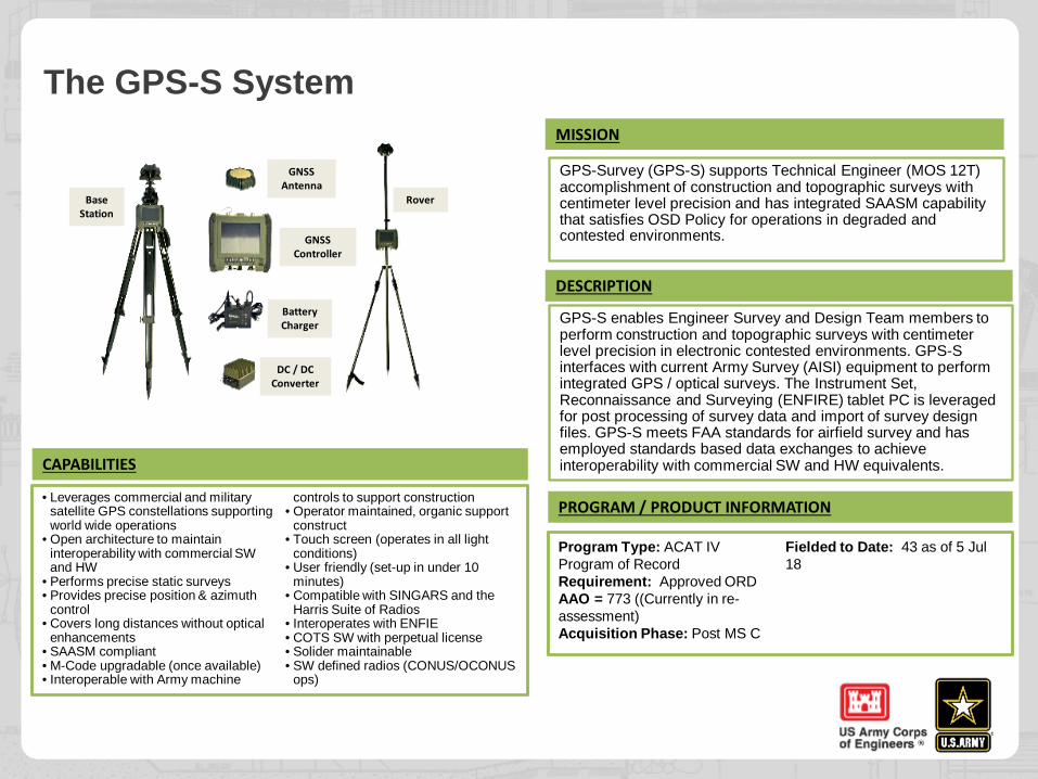
The GPS-S System
• Leverages commercial and military satellite GPS constellations supporting world wide operations
• Open architecture to maintain interoperability with commercial SW and HW
• Performs precise static surveys• Provides precise position & azimuth
control• Covers long distances without optical
enhancements• SAASM compliant • M-Code upgradable (once available) • Interoperable with Army machine
controls to support construction• Operator maintained, organic support
construct• Touch screen (operates in all light
conditions)• User friendly (set-up in under 10
minutes)• Compatible with SINGARS and the
Harris Suite of Radios • Interoperates with ENFIE • COTS SW with perpetual license• Solider maintainable• SW defined radios (CONUS/OCONUS
ops)
GPS-Survey (GPS-S) supports Technical Engineer (MOS 12T) accomplishment of construction and topographic surveys with centimeter level precision and has integrated SAASM capability that satisfies OSD Policy for operations in degraded and contested environments.
CAPABILITIES
MISSION
GPS-S enables Engineer Survey and Design Team members to perform construction and topographic surveys with centimeter level precision in electronic contested environments. GPS-S interfaces with current Army Survey (AISI) equipment to perform integrated GPS / optical surveys. The Instrument Set, Reconnaissance and Surveying (ENFIRE) tablet PC is leveraged for post processing of survey data and import of survey design files. GPS-S meets FAA standards for airfield survey and has employed standards based data exchanges to achieve interoperability with commercial SW and HW equivalents.
DESCRIPTION
PROGRAM / PRODUCT INFORMATION
Rover
GNSS Antenna
GNSS Controller
Battery Charger
DC / DC Converter
Base Station
Program Type: ACAT IV Program of RecordRequirement: Approved ORDAAO = 773 ((Currently in re-assessment)Acquisition Phase: Post MS C
Fielded to Date: 43 as of 5 Jul 18
Our Strategy 13
• “Swiss Army Knife”• Develop and field cross functional solutions for engineers, surveyors, divers,
designers, manager, warfighters and decision makers• Modern, ruggedized, auto population tools underpinned by COTS/GOTS• Data collection, analysis and sharing through enterprise tools• Integrated and co- dependent products that support multiple “like” missions• Easy to use interfaces “out of the box”
• Interoperable with Army Decision Systems• Multiple classification levels (NIPR/SIPR)• Meets current and evolving data interoperability requirements• Support military and non-military mission space
• Continuous modernization• End user driven• Leverage Army and Industry Science and Technology Research Initiatives• Maintain open architecture • Build in flexibility
• Modernity is a journey not an end state • Small investments vs large outlays• User + mission + industry are the drivers
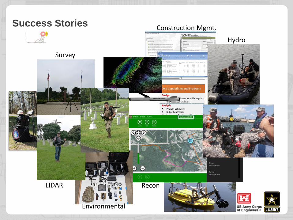
Success Stories
Environmental
Recon
Survey
Hydro
Construction Mgmt.
LIDAR
Our Challenges13
• Budget Cuts – Its hard to catch up and harder to stay ahead• Process – Not all capabilities need or should be treated equally• Demand – Cheaper, better, faster +1 “easier to use”• Transport – Managing Terrain requires geographically dispersed
stand alone solutions or “Great Pipes”• Underrated Product Line – Its not maneuver• COTS vs GOTS vs MCOTS vs???• User Needs – Not Static• Technology Pace – Shiny objects move fast• Training – Institutional vs on demand vs distance or all of them
everywhere• Time – You can’t stop it, you can’t get ahead and you never beat the
clock• Modernization – What’s the right tempo and how do you know when
you are off• Return On Investment – How do we calculate ROI early and often
and adjust

COTS/GOTS ACAT III/IV – Not Easy and Take Time
• S vs R; R don’t go away with COTS• Documents are a necessary “evil”• Time is not our friend• Process evolution clocks are not aligned to requirement, mission demands and
dollar clocks
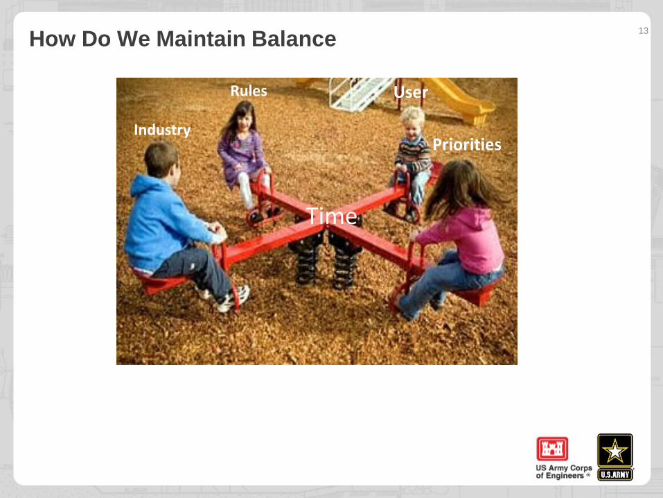
How Do We Maintain Balance 13
Industry
UserRules
Priorities
Time
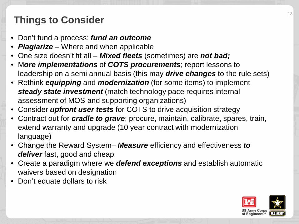
Things to Consider13
• Don’t fund a process; fund an outcome• Plagiarize – Where and when applicable• One size doesn’t fit all – Mixed fleets (sometimes) are not bad; • More implementations of COTS procurements; report lessons to
leadership on a semi annual basis (this may drive changes to the rule sets)• Rethink equipping and modernization (for some items) to implement
steady state investment (match technology pace requires internal assessment of MOS and supporting organizations)
• Consider upfront user tests for COTS to drive acquisition strategy• Contract out for cradle to grave; procure, maintain, calibrate, spares, train,
extend warranty and upgrade (10 year contract with modernization language)
• Change the Reward System– Measure efficiency and effectiveness to deliver fast, good and cheap
• Create a paradigm where we defend exceptions and establish automatic waivers based on designation
• Don’t equate dollars to risk
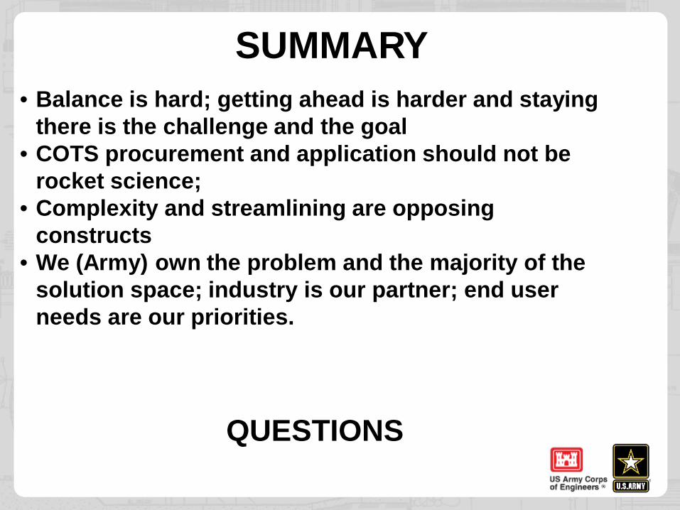
SUMMARY• Balance is hard; getting ahead is harder and staying
there is the challenge and the goal• COTS procurement and application should not be
rocket science;• Complexity and streamlining are opposing
constructs• We (Army) own the problem and the majority of the
solution space; industry is our partner; end user needs are our priorities.
QUESTIONS