inspire support in geonetwork opensource project | fx ... · multilingual getcapabilities document...
TRANSCRIPT
INSPIRE support in GeoNetwork opensource
December 2010
&INSPIRE support in GeoNetwork opensource
Neogeo technologies | 20101231 | 1
Table of Contents
Introduction....................................................................................31. Revision History..........................................................................................................42. Normative references.................................................................................................43. Status definition.........................................................................................................4
Metadata Implementing Rules..........................................................51. Metadata on datasets, series and services.................................................................52. INSPIRE specific constraints & extensions..................................................................53. Mapping.................................................................................................................... 124. JRC and GeoNetwork Schematron comparison.........................................................15
Discovery service technical guide...................................................181. Comments about the technical guidance v2.12.......................................................24
Data specification..........................................................................251. Data quality..............................................................................................................252. Mandatory and conditional element.........................................................................263. Conclusion................................................................................................................ 28
GeoNetwork internal mechanism notes...........................................291. CSW Search and Lucene indexing............................................................................292. CSW Search and pair fields.......................................................................................323. Multilingual metadata search status and improvements..........................................334. Harvesting and federated search.............................................................................33
GeoNetwork user interfaces for INSPIRE..........................................351. INSPIRE search form.................................................................................................352. Multilingual GetCapabilities document configuration interface................................363. INSPIRE view.............................................................................................................364. Linking metadata on datasets and services.............................................................365. gmd:Language element was used before 2.7.x series..............................................386. Adding control vocabulary from GEMET or other thesaurus.....................................387. Multilingual metadata editing...................................................................................398. INSPIRE view.............................................................................................................40
GeoNetwork configuration for INSPIRE............................................411. Enable Schematron validation for INSPIRE...............................................................412. GEMET Thesaurus, INSPIRE Theme and INSPIRE service taxonomy installation.......413. Activate INSPIRE view...............................................................................................414. Activate INSPIRE search form...................................................................................425. Schema suggestions mechanism.............................................................................426. Temporal reference indexing....................................................................................437. Configure suggestion lists for non codelist element.................................................438. Hide codelist values for easy editing........................................................................44
Conclusion.....................................................................................45
INSPIRE support in GeoNetwork opensourceNeogeo technologies | 20101231 | 2
INTRODUCTIONThe scope of this document is to detail the current status of GeoNetwork opensource project toward INSPIRE requirements based on the metadata implementing rules and the technical guidance for discovery service. The main objective is to draw a clear view of what parts of the application need improvements or may have different approaches. The last chapter of the document explains configuration steps to activate all INSPIRE options in existing version of GeoNetwork opensource.
INSPIRE support in GeoNetwork has been mainly made in the context of the following projects:
• GéoSource / BRGM / http://www.geosource.fr
• nationalgeoregister / GeoNovum / http://www.nationaalgeoregister.nl
• geocat.ch / Swisstopo / http://www.geocat.ch
• The Nordic Initiative / Denmark, Finland, Norway, Sweden
• Institut Bruxellois pour la Gestion de l'Environnement
• Euro-Mediterranean Information System on know-how in the Water sector / http://geo.semide.net/geonetwork
This document is based on GeoNetwork trunk (r7086). Some improvements have been done in the context of this document. Therefore most of the features are available in version 2.6.2 release 24th December 2010.
INSPIRE support in GeoNetwork opensourceNeogeo technologies | 20101231 | 3
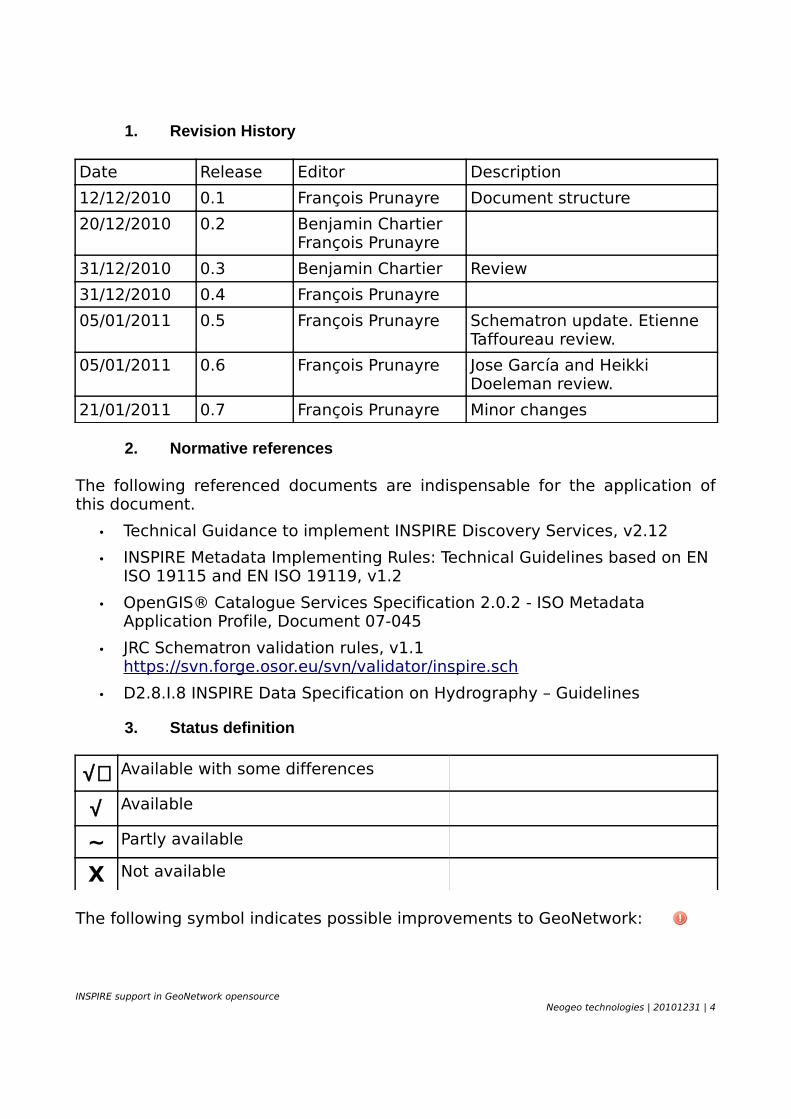
1. Revision History
Date Release Editor Description
12/12/2010 0.1 François Prunayre Document structure
20/12/2010 0.2 Benjamin ChartierFrançois Prunayre
31/12/2010 0.3 Benjamin Chartier Review
31/12/2010 0.4 François Prunayre
05/01/2011 0.5 François Prunayre Schematron update. Etienne Taffoureau review.
05/01/2011 0.6 François Prunayre Jose García and Heikki Doeleman review.
21/01/2011 0.7 François Prunayre Minor changes
2. Normative references
The following referenced documents are indispensable for the application of this document.
• Technical Guidance to implement INSPIRE Discovery Services, v2.12
• INSPIRE Metadata Implementing Rules: Technical Guidelines based on EN ISO 19115 and EN ISO 19119, v1.2
• OpenGIS® Catalogue Services Specification 2.0.2 - ISO Metadata Application Profile, Document 07-045
• JRC Schematron validation rules, v1.1 https://svn.forge.osor.eu/svn/validator/inspire.sch
• D2.8.I.8 INSPIRE Data Specification on Hydrography – Guidelines
3. Status definition
√+ Available with some differences
√ Available
~ Partly available
X Not available
The following symbol indicates possible improvements to GeoNetwork:
INSPIRE support in GeoNetwork opensourceNeogeo technologies | 20101231 | 4
METADATA IMPLEMENTING RULES
1. Metadata on datasets, series and services
The INSPIRE directive requires the capability to create metadata on spatial datasets or series or metadata on services using ISO19115 and ISO19119.
IR1 √ ISO19115 and ISO19119 support
GeoNetwork provide support for both standards with sample templates by default.
2. INSPIRE specific constraints & extensions
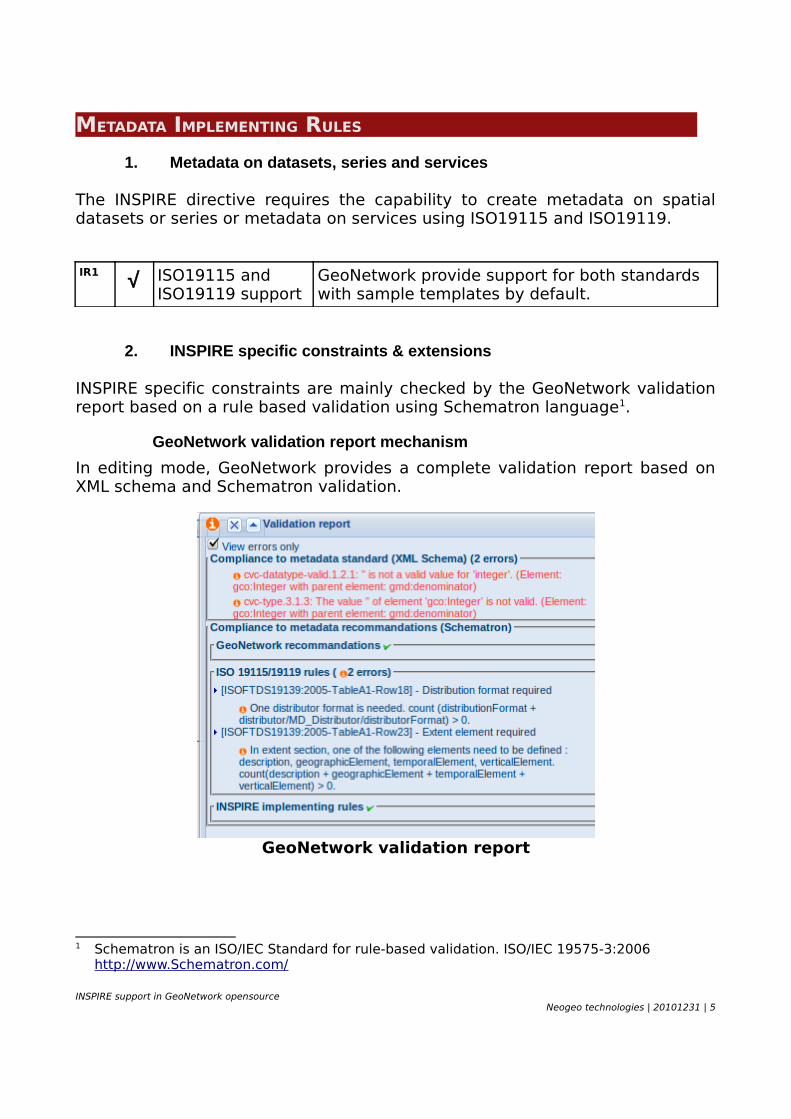
INSPIRE specific constraints are mainly checked by the GeoNetwork validation report based on a rule based validation using Schematron language1.
GeoNetwork validation report mechanism
In editing mode, GeoNetwork provides a complete validation report based on XML schema and Schematron validation.
GeoNetwork validation report
1 Schematron is an ISO/IEC Standard for rule-based validation. ISO/IEC 19575-3:2006 http://www.Schematron.com/
INSPIRE support in GeoNetwork opensourceNeogeo technologies | 20101231 | 5
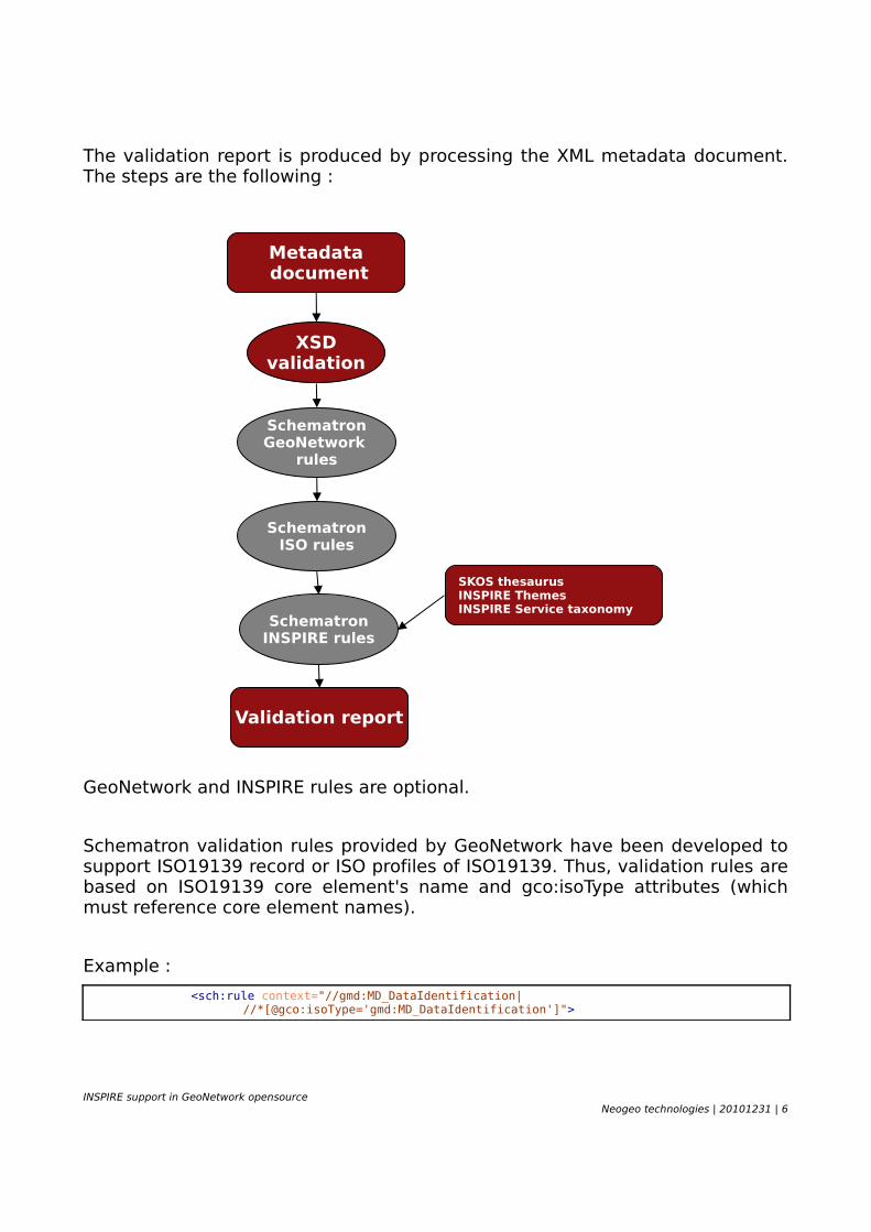
The validation report is produced by processing the XML metadata document. The steps are the following :
GeoNetwork and INSPIRE rules are optional.
Schematron validation rules provided by GeoNetwork have been developed to support ISO19139 record or ISO profiles of ISO19139. Thus, validation rules are based on ISO19139 core element's name and gco:isoType attributes (which must reference core element names).
Example :
<sch:rule context="//gmd:MD_DataIdentification|//*[@gco:isoType='gmd:MD_DataIdentification']">
INSPIRE support in GeoNetwork opensourceNeogeo technologies | 20101231 | 6
SKOS thesaurusINSPIRE ThemesINSPIRE Service taxonomy
XSDvalidation
Metadata document
SchematronGeoNetwork
rules
SchematronISO rules
SchematronINSPIRE rules
Validation report
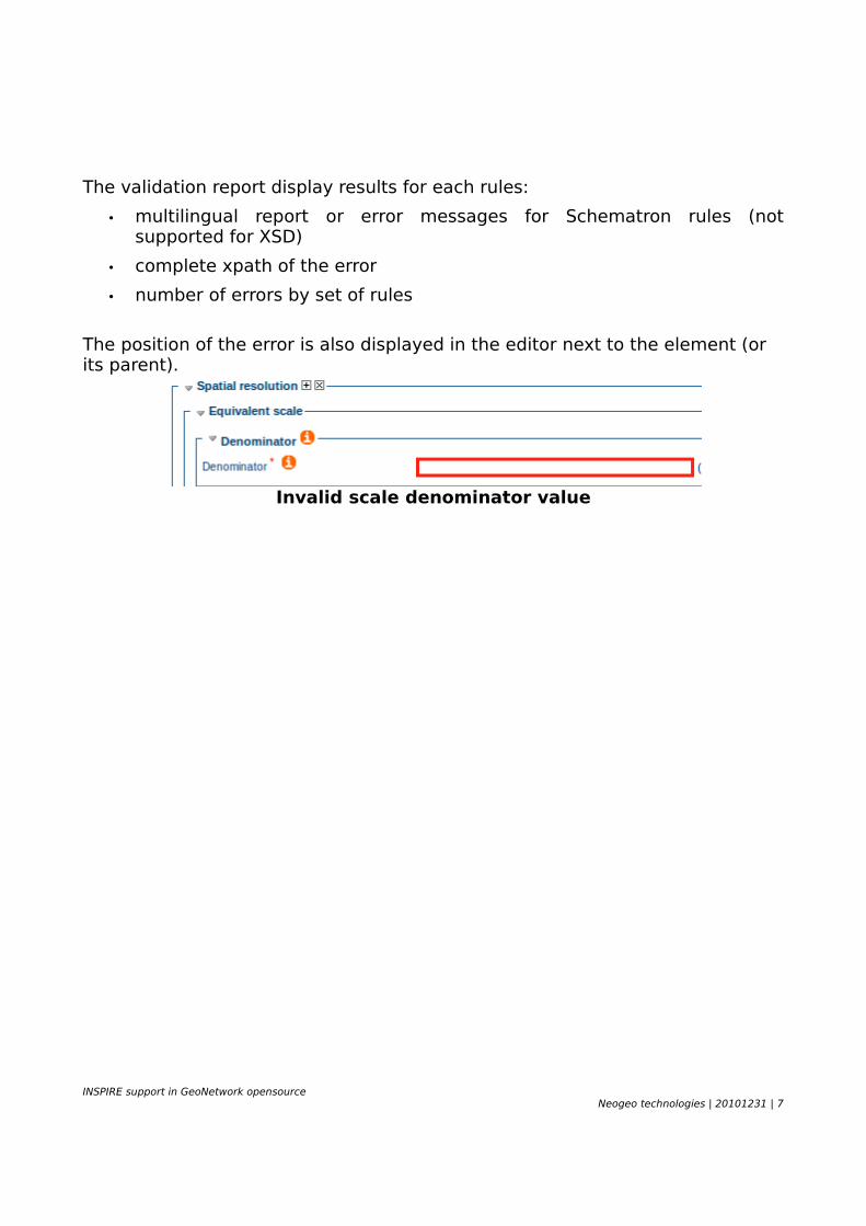
The validation report display results for each rules:
• multilingual report or error messages for Schematron rules (not supported for XSD)
• complete xpath of the error
• number of errors by set of rules
The position of the error is also displayed in the editor next to the element (or its parent).
Invalid scale denominator value
INSPIRE support in GeoNetwork opensourceNeogeo technologies | 20101231 | 7
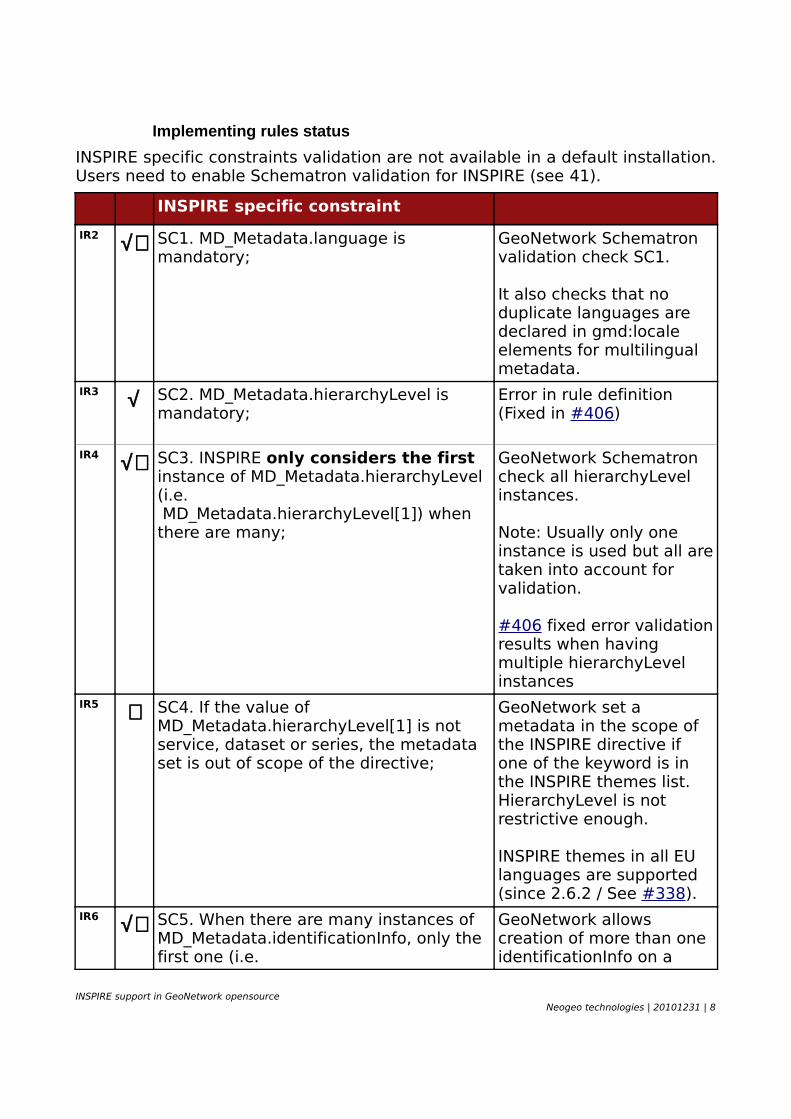
Implementing rules status
INSPIRE specific constraints validation are not available in a default installation. Users need to enable Schematron validation for INSPIRE (see 41).
INSPIRE specific constraint
IR2 √+ SC1. MD_Metadata.language is mandatory;
GeoNetwork Schematron validation check SC1.
It also checks that no duplicate languages are declared in gmd:locale elements for multilingual metadata.
IR3 √ SC2. MD_Metadata.hierarchyLevel is mandatory;
Error in rule definition (Fixed in #406)
IR4 √+ SC3. INSPIRE only considers the first instance of MD_Metadata.hierarchyLevel (i.e. MD_Metadata.hierarchyLevel[1]) when there are many;
GeoNetwork Schematron check all hierarchyLevel instances.
Note: Usually only one instance is used but all are taken into account for validation.
#406 fixed error validation results when having multiple hierarchyLevel instances
IR5 ∼ SC4. If the value of MD_Metadata.hierarchyLevel[1] is not service, dataset or series, the metadata set is out of scope of the directive;
GeoNetwork set a metadata in the scope of the INSPIRE directive if one of the keyword is in the INSPIRE themes list. HierarchyLevel is not restrictive enough.
INSPIRE themes in all EU languages are supported (since 2.6.2 / See #338).
IR6 √+ SC5. When there are many instances of MD_Metadata.identificationInfo, only the first one (i.e.
GeoNetwork allows creation of more than one identificationInfo on a
INSPIRE support in GeoNetwork opensourceNeogeo technologies | 20101231 | 8

MD_Metadata.identificationInfo[1]) concerns the current INSPIRE Resource;
record but this is not recommended and used seldomly. All metadata content is checked.
IR7 √ SC6. INSPIRE only considers the instance of MD_Metadata.dataQualityInfo applicable to the whole resource;
IR8 √ SC7. There shall not be more than one instance of MD_Metadata.identificationInfo[1].MD_Identification.citation.CI_Citation.date declared as a creation date (i.e. CI_Date.dateType having the creation value);
IR9 √ SC8. MD_Metadata.identificationInfo[1].MD_DataIdentification.citation.CI_Citation.identifier is mandatory for metadata sets related to spatial dataset and spatial dataset series;
IR10 √+ SC9. The data type of MD_Metadata.identificationInfo.MD_DataIdentification.language is the codelist LanguageCode from ISO/TS 19139;
GeoNetwork support both ISO syntax ie. <gmd:LanguageCode codeList="" codeListValue="eng" />or <gco:CharacterString>eng</gco:CharacterString>.
The default syntax in templates is based on gmd:LanguageCode (for 2.7.x series).
See 38
IR11 √ SC10.There is at least one instance ofMD_Metadata.identificationInfo[1].MD_DataIdentification.extent defining the geographic location of the resource as a geographic bounding box (i.e. an
INSPIRE support in GeoNetwork opensourceNeogeo technologies | 20101231 | 9
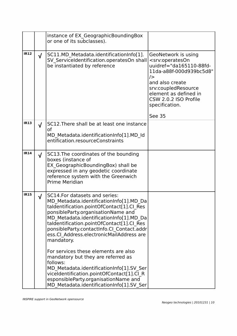
instance of EX_GeographicBoundingBox or one of its subclasses).
IR12 √ SC11.MD_Metadata.identificationInfo[1].SV_ServiceIdentification.operatesOn shall be instantiated by reference
GeoNetwork is using <srv:operatesOn uuidref="da165110-88fd-11da-a88f-000d939bc5d8" /> and also create srv:coupledResource element as defined in CSW 2.0.2 ISO Profile specification.
See 35IR13 √ SC12.There shall be at least one instance
of MD_Metadata.identificationInfo[1].MD_Identification.resourceConstraints
IR14 √ SC13.The coordinates of the bounding boxes (instance of EX_GeographicBoundingBox) shall be expressed in any geodetic coordinate reference system with the Greenwich Prime Meridian
IR15 √ SC14.For datasets and series:MD_Metadata.identificationInfo[1].MD_DataIdentification.pointOfContact[1].CI_ResponsibleParty.organisationName and MD_Metadata.identificationInfo[1].MD_DataIdentification.pointOfContact[1].CI_ResponsibleParty.contactInfo.CI_Contact.address.CI_Address.electronicMailAddress aremandatory.
For services these elements are also mandatory but they are referred as follows:MD_Metadata.identificationInfo[1].SV_ServiceIdentification.pointOfContact[1].CI_ResponsibleParty.organisationName and MD_Metadata.identificationInfo[1].SV_Ser
INSPIRE support in GeoNetwork opensourceNeogeo technologies | 20101231 | 10
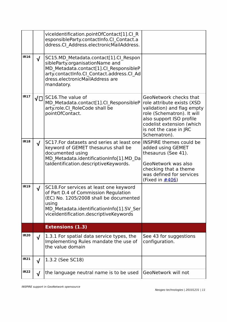
viceIdentification.pointOfContact[1].CI_ResponsibleParty.contactInfo.CI_Contact.address.CI_Address.electronicMailAddress.
IR16 √ SC15.MD_Metadata.contact[1].CI_ResponsibleParty.organisationName and MD_Metadata.contact[1].CI_ResponsibleParty.contactInfo.CI_Contact.address.CI_Address.electronicMailAddress are mandatory.
IR17 √+ SC16.The value of MD_Metadata.contact[1].CI_ResponsibleParty.role.CI_RoleCode shall be pointOfContact.
GeoNetwork checks that role attribute exists (XSD validation) and flag empty role (Schematron). It will also support ISO profile codelist extension (which is not the case in JRC Schematron).
IR18 √ SC17.For datasets and series at least one keyword of GEMET thesaurus shall be documented using MD_Metadata.identificationInfo[1].MD_DataIdentification.descriptiveKeywords.
INSPIRE themes could be added using GEMET thesaurus (See 41).
GeoNetwork was also checking that a theme was defined for services (Fixed in #406)
IR19 √ SC18.For services at least one keyword of Part D.4 of Commission Regulation (EC) No. 1205/2008 shall be documented using MD_Metadata.identificationInfo[1].SV_ServiceIdentification.descriptiveKeywords
Extensions (1.3)
IR20 √ 1.3.1 For spatial data service types, the Implementing Rules mandate the use of the value domain
See 43 for suggestions configuration.
IR21 √ 1.3.2 (See SC18)
IR22 √ the language neutral name is to be used GeoNetwork will not
INSPIRE support in GeoNetwork opensourceNeogeo technologies | 20101231 | 11
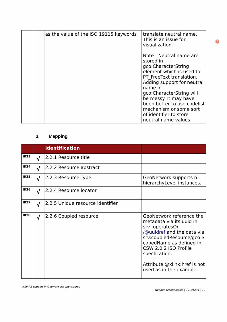
as the value of the ISO 19115 keywords translate neutral name. This is an issue for visualization.
Note : Neutral name are stored in gco:CharacterString element which is used to PT_FreeText translation. Adding support for neutral name in gco:CharacterString will be messy. It may have been better to use codelist mechanism or some sort of identifier to store neutral name values.
3. Mapping
Identification
IR23 √ 2.2.1 Resource title
IR24 √ 2.2.2 Resource abstract
IR25 √ 2.2.3 Resource Type GeoNetwork supports n hierarchyLevel instances.
IR26 √ 2.2.4 Resource locator
IR27 √ 2.2.5 Unique resource identifier
IR28 √ 2.2.6 Coupled resource GeoNetwork reference the metadata via its uuid in srv :operatesOn/@uuidref and the data via srv:coupledResource/gco:ScopedName as defined in CSW 2.0.2 ISO Profile specfication.
Attribute @xlink:href is not used as in the example.
INSPIRE support in GeoNetwork opensourceNeogeo technologies | 20101231 | 12
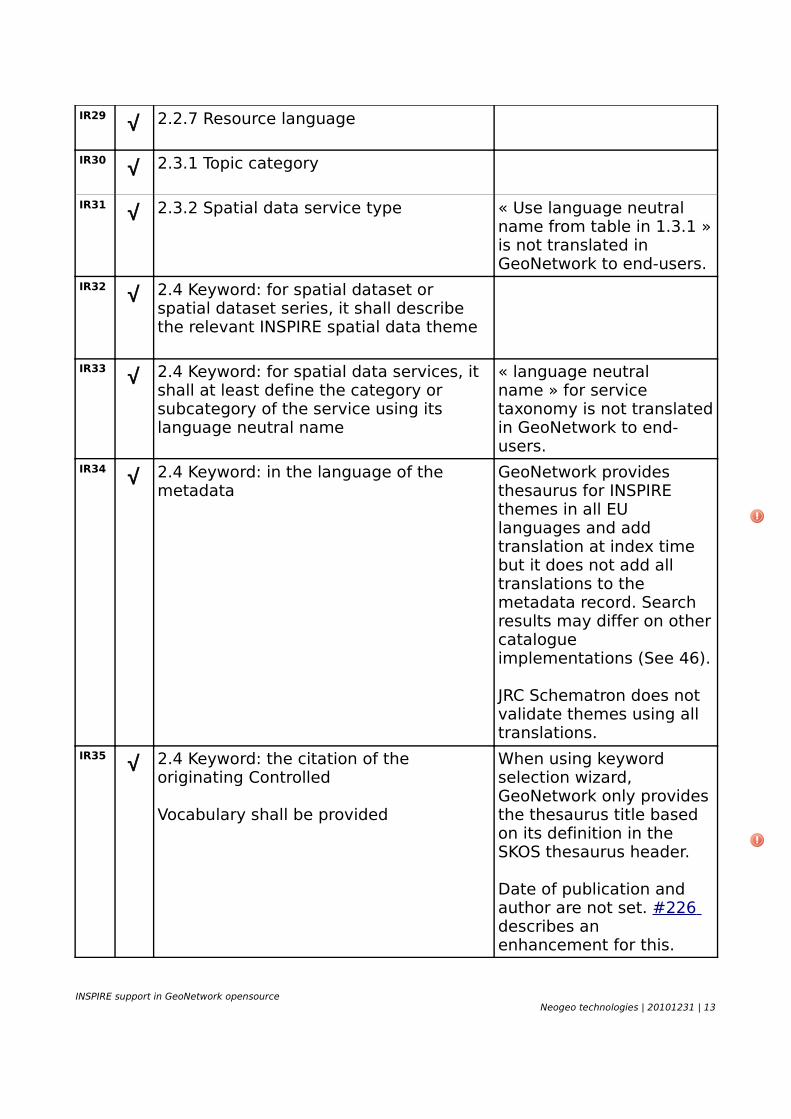
IR29 √ 2.2.7 Resource language
IR30 √ 2.3.1 Topic category
IR31 √ 2.3.2 Spatial data service type « Use language neutral name from table in 1.3.1 » is not translated in GeoNetwork to end-users.
IR32 √ 2.4 Keyword: for spatial dataset or spatial dataset series, it shall describe the relevant INSPIRE spatial data theme
IR33 √ 2.4 Keyword: for spatial data services, it shall at least define the category or subcategory of the service using its language neutral name
« language neutral name » for service taxonomy is not translated in GeoNetwork to end-users.
IR34 √ 2.4 Keyword: in the language of the metadata
GeoNetwork provides thesaurus for INSPIRE themes in all EU languages and add translation at index time but it does not add all translations to the metadata record. Search results may differ on other catalogue implementations (See 46).
JRC Schematron does not validate themes using all translations.
IR35 √ 2.4 Keyword: the citation of the originating Controlled
Vocabulary shall be provided
When using keyword selection wizard, GeoNetwork only provides the thesaurus title based on its definition in the SKOS thesaurus header.
Date of publication and author are not set. #226 describes an enhancement for this.
INSPIRE support in GeoNetwork opensourceNeogeo technologies | 20101231 | 13
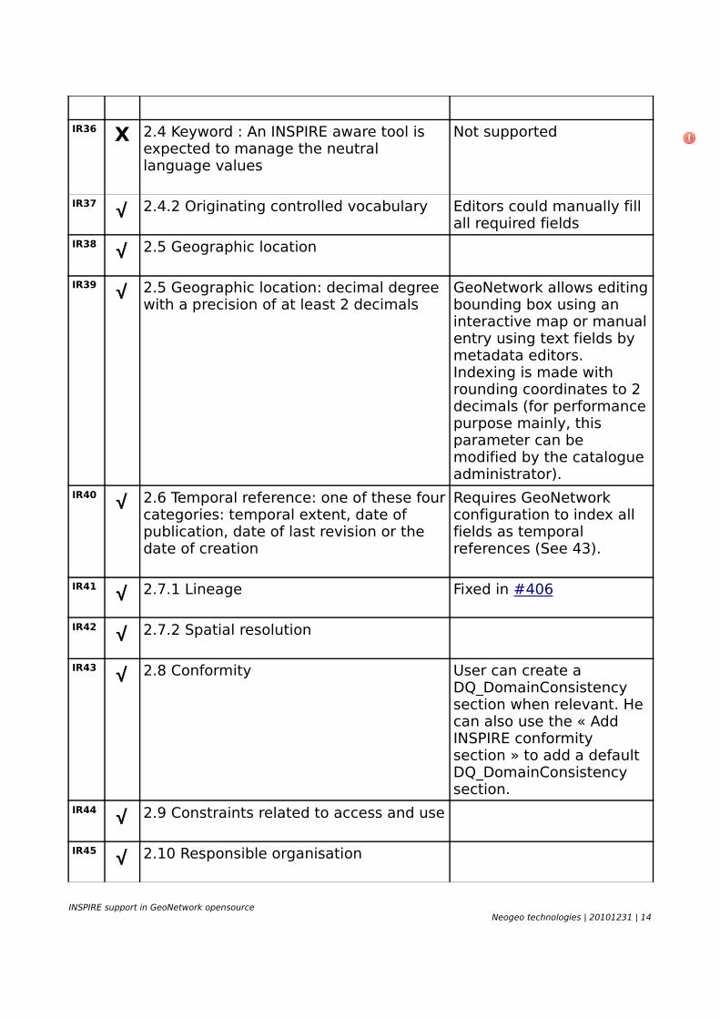
IR36 X 2.4 Keyword : An INSPIRE aware tool is expected to manage the neutral language values
Not supported
IR37 √ 2.4.2 Originating controlled vocabulary Editors could manually fill all required fields
IR38 √ 2.5 Geographic location
IR39 √ 2.5 Geographic location: decimal degree with a precision of at least 2 decimals
GeoNetwork allows editing bounding box using an interactive map or manual entry using text fields by metadata editors. Indexing is made with rounding coordinates to 2 decimals (for performance purpose mainly, this parameter can be modified by the catalogue administrator).
IR40 √ 2.6 Temporal reference: one of these four categories: temporal extent, date of publication, date of last revision or the date of creation
Requires GeoNetwork configuration to index all fields as temporal references (See 43).
IR41 √ 2.7.1 Lineage Fixed in #406
IR42 √ 2.7.2 Spatial resolution
IR43 √ 2.8 Conformity User can create a DQ_DomainConsistency section when relevant. He can also use the « Add INSPIRE conformity section » to add a default DQ_DomainConsistency section.
IR44 √ 2.9 Constraints related to access and use
IR45 √ 2.10 Responsible organisation
INSPIRE support in GeoNetwork opensourceNeogeo technologies | 20101231 | 14
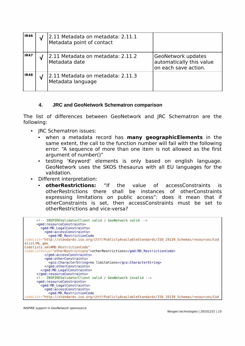
IR46 √ 2.11 Metadata on metadata: 2.11.1 Metadata point of contact
IR47 √ 2.11 Metadata on metadata: 2.11.2 Metadata date
GeoNetwork updates automatically this value on each save action.
IR48 √ 2.11 Metadata on metadata: 2.11.3 Metadata language
4. JRC and GeoNetwork Schematron comparison
The list of differences between GeoNetwork and JRC Schematron are the following:
• JRC Schematron issues:• when a metadata record has many geographicElements in the
same extent, the call to the function number will fail with the following error: “A sequence of more than one item is not allowed as the first argument of number()”
• testing 'Keyword' elements is only based on english language. GeoNetwork uses the SKOS thesaurus with all EU languages for the validation.
• Different interpretation:• otherRestrictions: “If the value of accessConstraints is
otherRestrictions there shall be instances of otherConstraints expressing limitations on public access”: does it mean that if otherConstraints is set, then accessConstraints must be set to otherRestrictions and vice-versa?
<!-- INSPIREValidatorClient valid / GeoNetwork valid --> <gmd:resourceConstraints> <gmd:MD_LegalConstraints> <gmd:accessConstraints> <gmd:MD_RestrictionCode codeList="http://standards.iso.org/ittf/PubliclyAvailableStandards/ISO_19139_Schemas/resources/Codelist/ML_gmxCodelists.xml#MD_RestrictionCode" codeListValue="otherRestrictions">otherRestrictions</gmd:MD_RestrictionCode> </gmd:accessConstraints> <gmd:otherConstraints> <gco:CharacterString>no limitations</gco:CharacterString> </gmd:otherConstraints> </gmd:MD_LegalConstraints> </gmd:resourceConstraints> <!-- INSPIREValidatorClient valid / GeoNetwork invalid --> <gmd:resourceConstraints> <gmd:MD_LegalConstraints> <gmd:accessConstraints> <gmd:MD_RestrictionCode codeList="http://standards.iso.org/ittf/PubliclyAvailableStandards/ISO_19139_Schemas/resources/Cod
INSPIRE support in GeoNetwork opensourceNeogeo technologies | 20101231 | 15
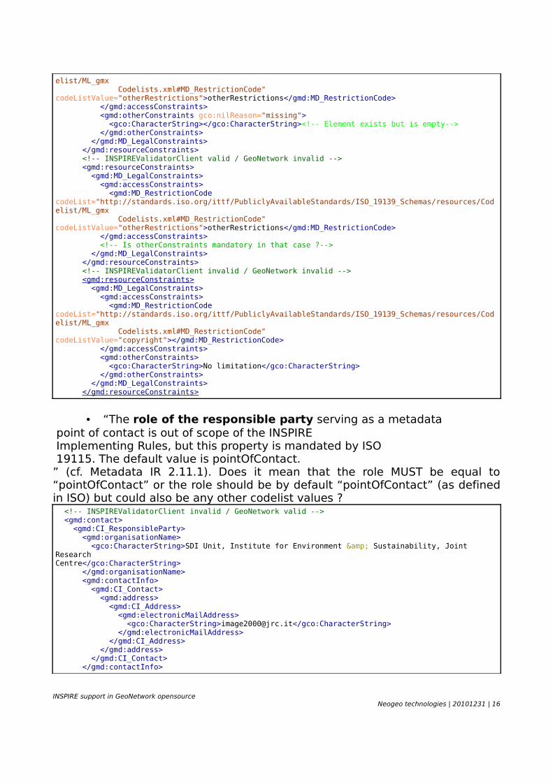
elist/ML_gmx Codelists.xml#MD_RestrictionCode" codeListValue="otherRestrictions">otherRestrictions</gmd:MD_RestrictionCode> </gmd:accessConstraints> <gmd:otherConstraints gco:nilReason="missing"> <gco:CharacterString></gco:CharacterString><!-- Element exists but is empty--> </gmd:otherConstraints> </gmd:MD_LegalConstraints> </gmd:resourceConstraints> <!-- INSPIREValidatorClient valid / GeoNetwork invalid --> <gmd:resourceConstraints> <gmd:MD_LegalConstraints> <gmd:accessConstraints> <gmd:MD_RestrictionCode codeList="http://standards.iso.org/ittf/PubliclyAvailableStandards/ISO_19139_Schemas/resources/Codelist/ML_gmx Codelists.xml#MD_RestrictionCode" codeListValue="otherRestrictions">otherRestrictions</gmd:MD_RestrictionCode> </gmd:accessConstraints> <!-- Is otherConstraints mandatory in that case ?--> </gmd:MD_LegalConstraints> </gmd:resourceConstraints> <!-- INSPIREValidatorClient invalid / GeoNetwork invalid --> <gmd:resourceConstraints> <gmd:MD_LegalConstraints> <gmd:accessConstraints> <gmd:MD_RestrictionCode codeList="http://standards.iso.org/ittf/PubliclyAvailableStandards/ISO_19139_Schemas/resources/Codelist/ML_gmx Codelists.xml#MD_RestrictionCode" codeListValue="copyright"></gmd:MD_RestrictionCode> </gmd:accessConstraints> <gmd:otherConstraints> <gco:CharacterString>No limitation</gco:CharacterString> </gmd:otherConstraints> </gmd:MD_LegalConstraints> </gmd:resourceConstraints>
• “The role of the responsible party serving as a metadata point of contact is out of scope of the INSPIRE Implementing Rules, but this property is mandated by ISO 19115. The default value is pointOfContact.” (cf. Metadata IR 2.11.1). Does it mean that the role MUST be equal to “pointOfContact” or the role should be by default “pointOfContact” (as defined in ISO) but could also be any other codelist values ? <!-- INSPIREValidatorClient invalid / GeoNetwork valid --> <gmd:contact> <gmd:CI_ResponsibleParty> <gmd:organisationName> <gco:CharacterString>SDI Unit, Institute for Environment & Sustainability, Joint ResearchCentre</gco:CharacterString> </gmd:organisationName> <gmd:contactInfo> <gmd:CI_Contact> <gmd:address> <gmd:CI_Address> <gmd:electronicMailAddress> <gco:CharacterString>[email protected]</gco:CharacterString> </gmd:electronicMailAddress> </gmd:CI_Address> </gmd:address> </gmd:CI_Contact> </gmd:contactInfo>
INSPIRE support in GeoNetwork opensourceNeogeo technologies | 20101231 | 16
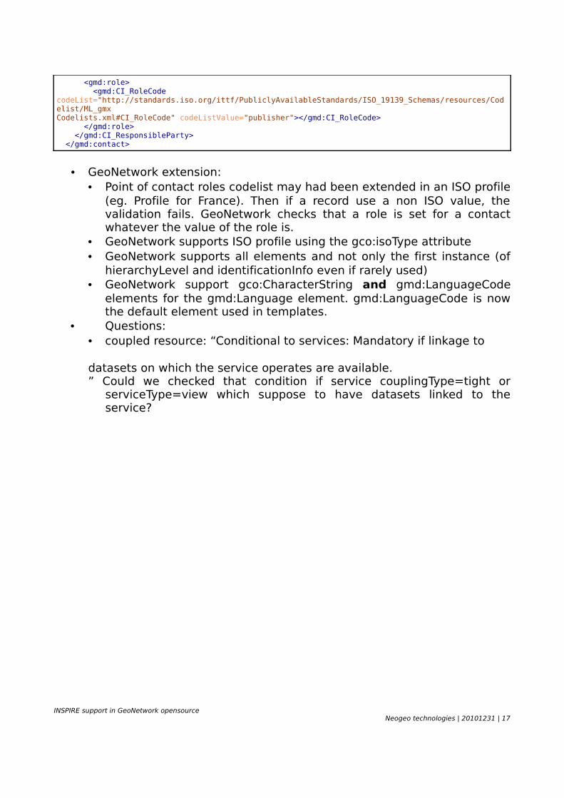
<gmd:role> <gmd:CI_RoleCode codeList="http://standards.iso.org/ittf/PubliclyAvailableStandards/ISO_19139_Schemas/resources/Codelist/ML_gmxCodelists.xml#CI_RoleCode" codeListValue="publisher"></gmd:CI_RoleCode> </gmd:role> </gmd:CI_ResponsibleParty> </gmd:contact>
• GeoNetwork extension:• Point of contact roles codelist may had been extended in an ISO profile
(eg. Profile for France). Then if a record use a non ISO value, the validation fails. GeoNetwork checks that a role is set for a contact whatever the value of the role is.
• GeoNetwork supports ISO profile using the gco:isoType attribute• GeoNetwork supports all elements and not only the first instance (of
hierarchyLevel and identificationInfo even if rarely used)• GeoNetwork support gco:CharacterString and gmd:LanguageCode
elements for the gmd:Language element. gmd:LanguageCode is now the default element used in templates.
• Questions:• coupled resource: “Conditional to services: Mandatory if linkage to
datasets on which the service operates are available.” Could we checked that condition if service couplingType=tight or
serviceType=view which suppose to have datasets linked to the service?
INSPIRE support in GeoNetwork opensourceNeogeo technologies | 20101231 | 17
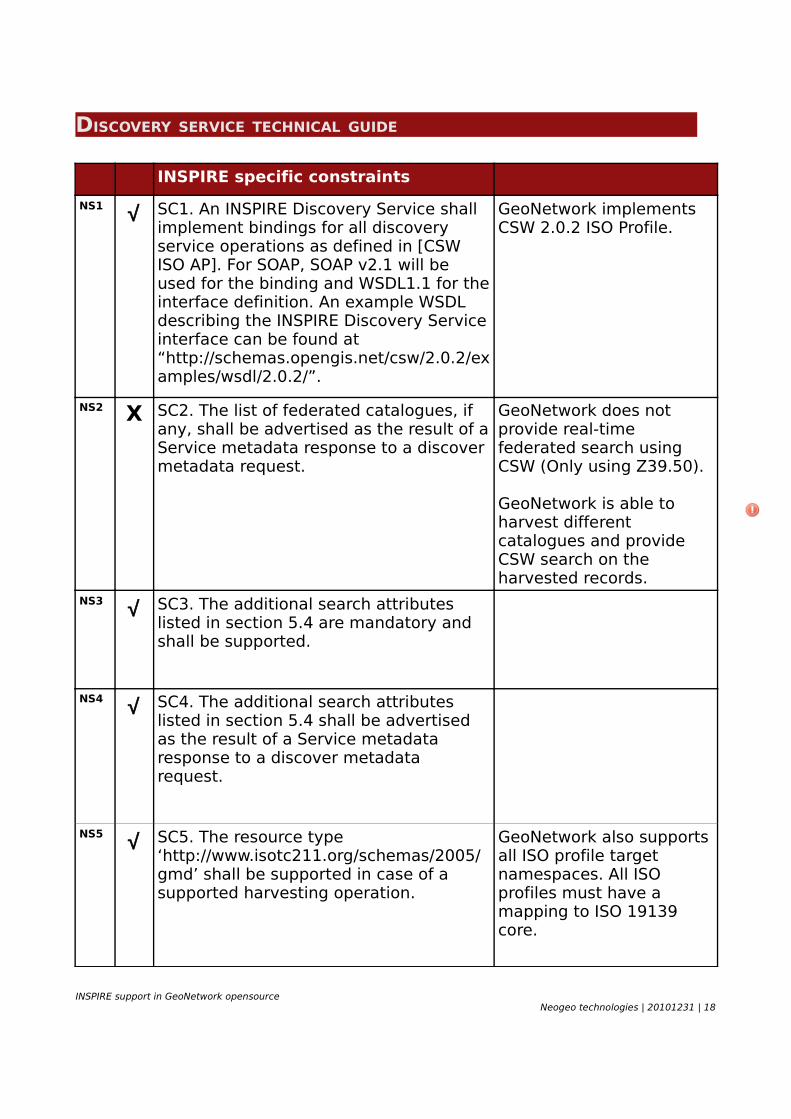
DISCOVERY SERVICE TECHNICAL GUIDE
INSPIRE specific constraints
NS1 √ SC1. An INSPIRE Discovery Service shall implement bindings for all discovery service operations as defined in [CSW ISO AP]. For SOAP, SOAP v2.1 will be used for the binding and WSDL1.1 for the interface definition. An example WSDL describing the INSPIRE Discovery Service interface can be found at “http://schemas.opengis.net/csw/2.0.2/examples/wsdl/2.0.2/”.
GeoNetwork implements CSW 2.0.2 ISO Profile.
NS2 X SC2. The list of federated catalogues, if any, shall be advertised as the result of a Service metadata response to a discover metadata request.
GeoNetwork does not provide real-time federated search using CSW (Only using Z39.50).
GeoNetwork is able to harvest different catalogues and provide CSW search on the harvested records.
NS3 √ SC3. The additional search attributes listed in section 5.4 are mandatory and shall be supported.
NS4 √ SC4. The additional search attributes listed in section 5.4 shall be advertised as the result of a Service metadata response to a discover metadata request.
NS5 √ SC5. The resource type ‘http://www.isotc211.org/schemas/2005/gmd’ shall be supported in case of a supported harvesting operation.
GeoNetwork also supports all ISO profile target namespaces. All ISO profiles must have a mapping to ISO 19139 core.
INSPIRE support in GeoNetwork opensourceNeogeo technologies | 20101231 | 18
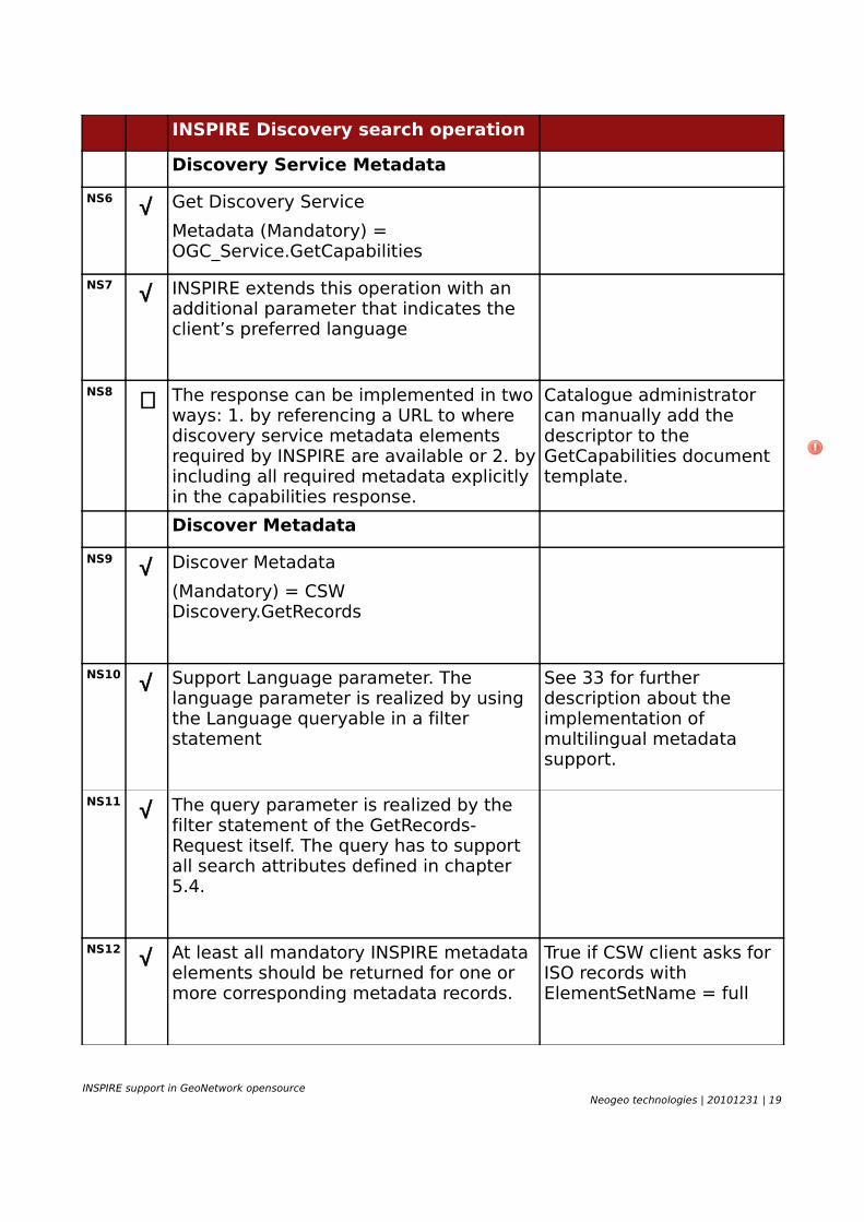
INSPIRE Discovery search operation
Discovery Service Metadata
NS6 √ Get Discovery Service
Metadata (Mandatory) = OGC_Service.GetCapabilities
NS7 √ INSPIRE extends this operation with an additional parameter that indicates the client’s preferred language
NS8 ∼ The response can be implemented in two ways: 1. by referencing a URL to where discovery service metadata elements required by INSPIRE are available or 2. by including all required metadata explicitly in the capabilities response.
Catalogue administrator can manually add the descriptor to the GetCapabilities document template.
Discover Metadata
NS9 √ Discover Metadata
(Mandatory) = CSW Discovery.GetRecords
NS10 √ Support Language parameter. The language parameter is realized by using the Language queryable in a filter statement
See 33 for further description about the implementation of multilingual metadata support.
NS11 √ The query parameter is realized by the filter statement of the GetRecords-Request itself. The query has to support all search attributes defined in chapter 5.4.
NS12 √ At least all mandatory INSPIRE metadata elements should be returned for one or more corresponding metadata records.
True if CSW client asks for ISO records with ElementSetName = full
INSPIRE support in GeoNetwork opensourceNeogeo technologies | 20101231 | 19
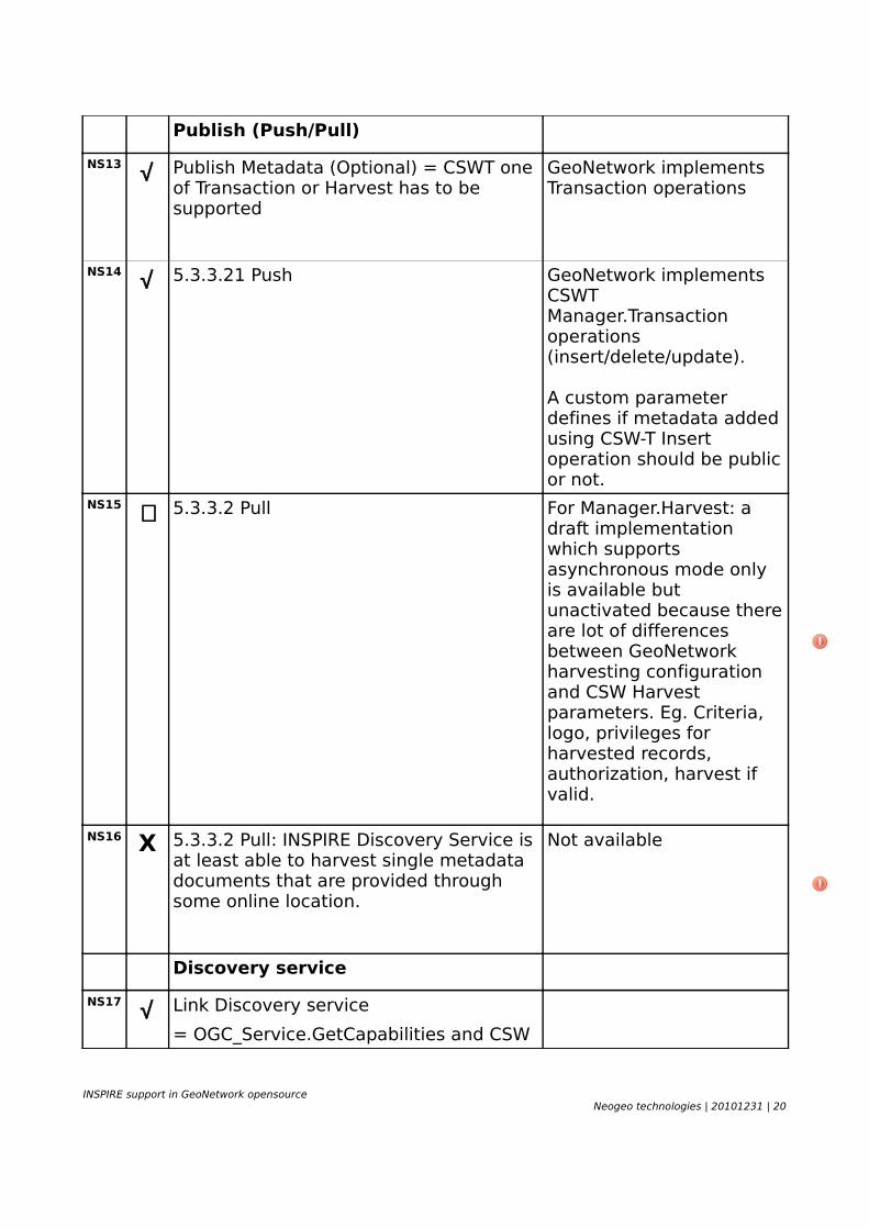
Publish (Push/Pull)
NS13 √ Publish Metadata (Optional) = CSWT one of Transaction or Harvest has to be supported
GeoNetwork implements Transaction operations
NS14 √ 5.3.3.21 Push GeoNetwork implements CSWT Manager.Transaction operations (insert/delete/update).
A custom parameter defines if metadata added using CSW-T Insert operation should be public or not.
NS15 ∼ 5.3.3.2 Pull For Manager.Harvest: a draft implementation which supports asynchronous mode only is available but unactivated because there are lot of differences between GeoNetwork harvesting configuration and CSW Harvest parameters. Eg. Criteria, logo, privileges for harvested records, authorization, harvest if valid.
NS16 X 5.3.3.2 Pull: INSPIRE Discovery Service is at least able to harvest single metadata documents that are provided through some online location.
Not available
Discovery service
NS17 √ Link Discovery service
= OGC_Service.GetCapabilities and CSW
INSPIRE support in GeoNetwork opensourceNeogeo technologies | 20101231 | 20
Discovery.GetRecords
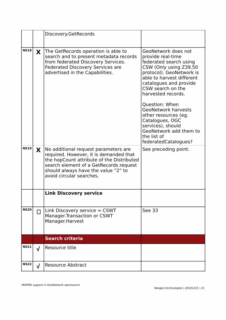
NS18 X The GetRecords operation is able to search and to present metadata records from federated Discovery Services. Federated Discovery Services are advertised in the Capabilities.
GeoNetwork does not provide real-time federated search using CSW (Only using Z39.50 protocol). GeoNetwork is able to harvest different catalogues and provide CSW search on the harvested records.
Question: When GeoNetwork harvests other resources (eg. Catalogues, OGC services), should GeoNetwork add them to the list of federatedCatalogues?
NS19 X No additional request parameters are required. However, it is demanded that the hopCount attribute of the Distributed search element of a GetRecords request should always have the value “2” to avoid circular searches.
See preceding point.
Link Discovery service
NS20 ∼ Link Discovery service = CSWT Manager.Transaction or CSWT Manager.Harvest
See 33
Search criteria
NS21 √ Resource title
NS22 √ Resource Abstract
INSPIRE support in GeoNetwork opensourceNeogeo technologies | 20101231 | 21
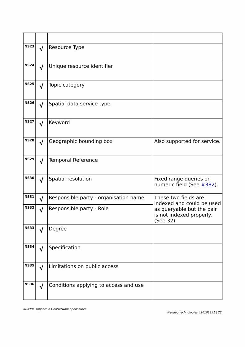
NS23 √ Resource Type
NS24 √ Unique resource identifier
NS25 √ Topic category
NS26 √ Spatial data service type
NS27 √ Keyword
NS28 √ Geographic bounding box Also supported for service.
NS29 √ Temporal Reference
NS30 √ Spatial resolution Fixed range queries on numeric field (See #382).
NS31 √ Responsible party - organisation name These two fields are indexed and could be used as queryable but the pair is not indexed properly. (See 32)
NS32 √ Responsible party - Role
NS33 √ Degree
NS34 √ Specification
NS35 √ Limitations on public access
NS36 √ Conditions applying to access and use
INSPIRE support in GeoNetwork opensourceNeogeo technologies | 20101231 | 22

NS37 √ Lineage
Language requirements
NS38 √ 5.5.1 GetCapabilities: A network service metadata response shall contain a list of the natural languages supported by the service. This list shall contain one or more languages that are supported.
Since 2.6.2
NS39 √ 5.5.2 GetRecord: a client CSW Discovery.GetRecords request containing no language specific filter is to be responded including all metadata elements that comply to the request independent from any language.
NS40 √ 5.5.2 GetRecord: a client CSW Discovery.GetRecords request containing a language specific filter requiring a response of metadata records of that specific language.
Question: if a metadata record is multilingual (eg. fre + eng), some of the elements are translated. Should the metadata be returned if the CSW client ask for eng and fre? Should the translated element be returned in a specific languages?
See 39NS41 ~ 5.5.2 GetRecord: an invalid client CSW
Discovery.GetRecords request (not compliant to CSW ISO AP) containing a language specific filter is to be responded with an exception in the default or in a requested and supported language. The use of a language specific filter itself shall not raise an exception.
Exceptions returned in english.
NS42 X 5.5.3 : multilingual error messages
INSPIRE support in GeoNetwork opensourceNeogeo technologies | 20101231 | 23
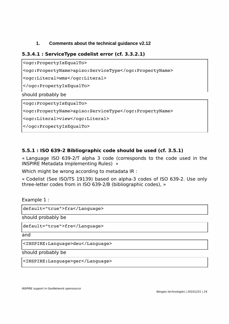
1. Comments about the technical guidance v2.12
5.3.4.1 : ServiceType codelist error (cf. 3.3.2.1)
<ogc:PropertyIsEqualTo>
<ogc:PropertyName>apiso:ServiceType</ogc:PropertyName>
<ogc:Literal>wms</ogc:Literal>
</ogc:PropertyIsEqualTo>
should probably be
<ogc:PropertyIsEqualTo>
<ogc:PropertyName>apiso:ServiceType</ogc:PropertyName>
<ogc:Literal>view</ogc:Literal>
</ogc:PropertyIsEqualTo>
5.5.1 : ISO 639-2 Bibliographic code should be used (cf. 3.5.1)
« Language ISO 639-2/T alpha 3 code (corresponds to the code used in the INSPIRE Metadata Implementing Rules) »
Which might be wrong according to metadata IR :
« Codelist (See ISO/TS 19139) based on alpha-3 codes of ISO 639-2. Use only three-letter codes from in ISO 639-2/B (bibliographic codes), »
Example 1 :
default="true">fra</Language>
should probably be
default="true">fre</Language>
and
<INSPIRE:Language>deu</Language>
should probably be
<INSPIRE:Language>ger</Language>
INSPIRE support in GeoNetwork opensourceNeogeo technologies | 20101231 | 24

DATA SPECIFICATIONWhen metadata are reported for a complete dataset or dataset series, the information should be added to the metadata record for the resource. This section details the main metadata requirements defined by the data specification focusing on the Hydrography data specification. The idea is to show what may be required for better data description in the metadata catalogue.
1. Data quality
The main data specification focus about metadata is to better describe the quality of the dataset.
√ The scope element (of type DQ_Scope) of the DQ_DataQuality subtype should be used to
encode the scope.
√ Only the following values should be used for the level element of DQ_Scope: Series,
Dataset, featureType.
X If the level is featureType the levelDescription/MDScopeDescription/features element (of type Set< GF_FeatureType>) shall be used to list the feature type names.
GeoNetwork needs improvements to create references for the set of features.
Other data specifications recommend editing of the maintenance section (eg. Geographical names). This could be achieve in GeoNetwork using the following interface:
INSPIRE support in GeoNetwork opensourceNeogeo technologies | 20101231 | 25
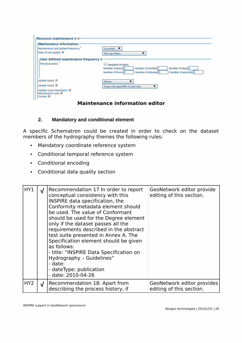
Maintenance information editor
2. Mandatory and conditional element
A specific Schematron could be created in order to check on the dataset members of the hydrography themes the following rules:
• Mandatory coordinate reference system
• Conditional temporal reference system
• Conditional encoding
• Conditional data quality section
HY1 √ Recommendation 17 In order to report conceptual consistency with this INSPIRE data specification, the Conformity metadata element should be used. The value of Conformant should be used for the Degree element only if the dataset passes all the requirements described in the abstract test suite presented in Annex A. The Specification element should be given as follows:- title: “INSPIRE Data Specification on Hydrography – Guidelines”- date:- dateType: publication- date: 2010-04-26
GeoNetwork editor provide editing of this section.
HY2 √ Recommendation 18: Apart from describing the process history, if
GeoNetwork editor provides editing of this section.
INSPIRE support in GeoNetwork opensourceNeogeo technologies | 20101231 | 26
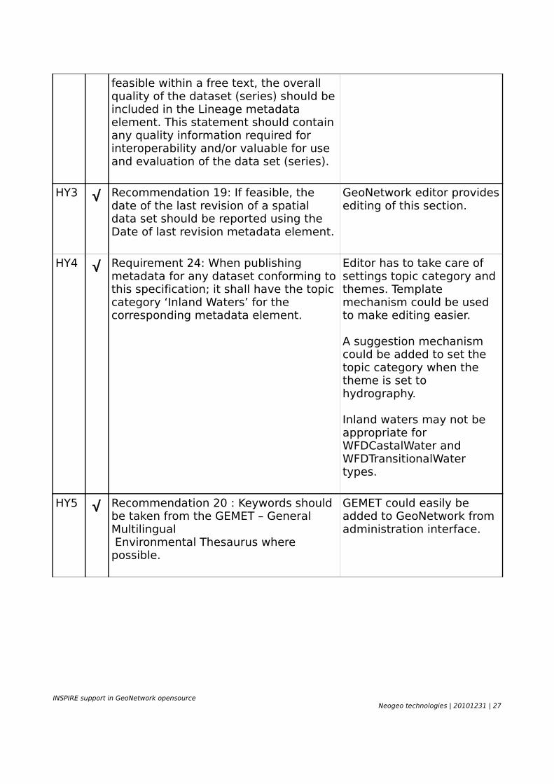
feasible within a free text, the overall quality of the dataset (series) should be included in the Lineage metadata element. This statement should contain any quality information required for interoperability and/or valuable for use and evaluation of the data set (series).
HY3 √ Recommendation 19: If feasible, the date of the last revision of a spatial data set should be reported using the Date of last revision metadata element.
GeoNetwork editor provides editing of this section.
HY4 √ Requirement 24: When publishing metadata for any dataset conforming to this specification; it shall have the topic category ‘Inland Waters’ for the corresponding metadata element.
Editor has to take care of settings topic category and themes. Template mechanism could be used to make editing easier.
A suggestion mechanism could be added to set the topic category when the theme is set to hydrography.
Inland waters may not be appropriate for WFDCastalWater and WFDTransitionalWater types.
HY5 √ Recommendation 20 : Keywords should be taken from the GEMET – General Multilingual Environmental Thesaurus where possible.
GEMET could easily be added to GeoNetwork from administration interface.
INSPIRE support in GeoNetwork opensourceNeogeo technologies | 20101231 | 27
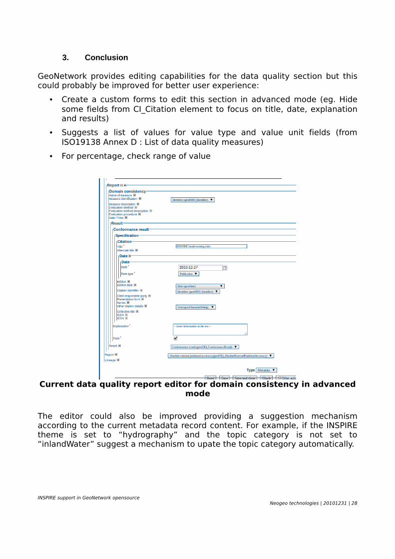
3. Conclusion
GeoNetwork provides editing capabilities for the data quality section but this could probably be improved for better user experience:
• Create a custom forms to edit this section in advanced mode (eg. Hide some fields from CI_Citation element to focus on title, date, explanation and results)
• Suggests a list of values for value type and value unit fields (from ISO19138 Annex D : List of data quality measures)
• For percentage, check range of value
Current data quality report editor for domain consistency in advanced mode
The editor could also be improved providing a suggestion mechanism according to the current metadata record content. For example, if the INSPIRE theme is set to “hydrography” and the topic category is not set to “inlandWater” suggest a mechanism to upate the topic category automatically.
INSPIRE support in GeoNetwork opensourceNeogeo technologies | 20101231 | 28
GEONETWORK INTERNAL MECHANISM NOTESThis section describes some internal mechanisms of GeoNetwork which may trigger non expected results when using GeoNetwork regarding INSPIRE or CSW specification.
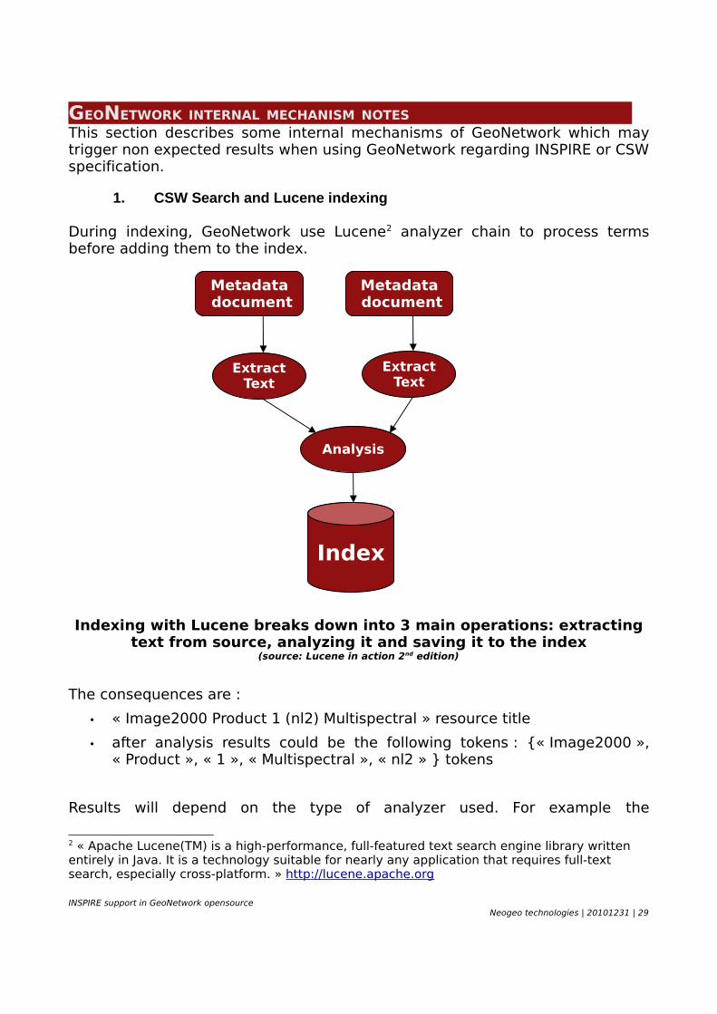
1. CSW Search and Lucene indexing
During indexing, GeoNetwork use Lucene2 analyzer chain to process terms before adding them to the index.
Indexing with Lucene breaks down into 3 main operations: extracting text from source, analyzing it and saving it to the index
(source: Lucene in action 2nd edition)
The consequences are :
• « Image2000 Product 1 (nl2) Multispectral » resource title
• after analysis results could be the following tokens : {« Image2000 », « Product », « 1 », « Multispectral », « nl2 » } tokens
Results will depend on the type of analyzer used. For example the
2 « Apache Lucene(TM) is a high-performance, full-featured text search engine library written entirely in Java. It is a technology suitable for nearly any application that requires full-text search, especially cross-platform. » http://lucene.apache.org
INSPIRE support in GeoNetwork opensourceNeogeo technologies | 20101231 | 29
Metadata document
ExtractText
Metadata document
Index
ExtractText
Analysis
StandardAnalyzer removes english stopwords and the FrenchAnalyzer removes french stopwords. The best analyzer to use depends on the metadata field and on the metadata content.
Indexing parameters are fully configurable in GeoNetwork:• define default analyzer to use for all fields• define custom analyzer per field (eg. KeywordAnalyzer for
gmd:descriptiveKeywords)• tokenized field or not (eg. A field with the title not tokenized exists for
sorting)• index field as numeric or text
As mentioned previously, GeoNetwork uses a search engine (ie. Lucene) to do the search, so queries will not behave exactly like a classical SQL query.
An example:
• an SQL query « WHERE TITLE ='product' » will not return any results
• but a CSW query with CQL filter with « title='product' » will return the result because:
• title field is tokenized so product is one token of the title
• a LowerCaseFilter is applied so « Product » in the title has been indexed as « product »
Analyzers are also applied at search time in a per field basis in order to apply the same analyzer to indexed content and searched terms in order to have relevant queries. In that case, « title='product' » will be equal to « title='ProDucT' ». Wildcard search are supported by GeoNetwork but it might not work as expected according to the analyzer/field used.
Different behaviors could be observed on other implementations3:
• geocatalogue.fr : title='ACCIDENTOLOGIE' returns records (eg. “Accidentologie en Charente-Maritime”).
• eXcat : title='gewassenbestand' and title='lgn4 gewassenbestand' return empty set, but title='LGN4 gewassenbestand' don't.
• MDweb : title='Pélardon' returns records (eg. “AOC Pélardon”)
• others ?
3 Example provided will depend on the catalogue content and the date the query is executed.
INSPIRE support in GeoNetwork opensourceNeogeo technologies | 20101231 | 30
For the time being, GeoNetwork searchers behave similarly. The catalogue search interface will return similar results to the ones returned with the CSW interface. Therefore, users could decide to not tokenize fields, and even not analyze fields in GeoNetwork. In such a case, search queries needs to implicitly add lower-case filtering and wildcards in order to retrieve relevant results.
GeoNetwork search engine also supports:
• fuzzy query search. Eg the following search will find the image2000 record (even with the extra « s » of product or with a typo like “prodict”)
<Filter>
<And>
<PropertyIsEqualTo>
<PropertyName>similarity</PropertyName>
<Literal>.7</Literal>
</PropertyIsEqualTo>
<PropertyIsEqualTo>
<PropertyName>title</PropertyName>
<Literal>products</Literal>
</PropertyIsEqualTo>
</And>
</Filter>
• Relevancy computation (default sort order) : CSW results are sorted by relevance by default. Catalogue administrator could decide to define custom boosting query in order to promote different types of records. A RecencyBoostingQuery is provided as an example in order to promote recent documents to the top of the results set.
INSPIRE support in GeoNetwork opensourceNeogeo technologies | 20101231 | 31
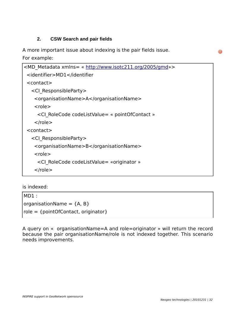
2. CSW Search and pair fields
A more important issue about indexing is the pair fields issue.
For example:
<MD_Metadata xmlns= « http://www.isotc211.org/2005/gmd»>
<identifier>MD1</identifier
<contact>
<CI_ResponsibleParty>
<organisationName>A</organisationName>
<role>
<CI_RoleCode codeListValue= « pointOfContact »
</role>
<contact>
<CI_ResponsibleParty>
<organisationName>B</organisationName>
<role>
<CI_RoleCode codeListValue= «originator »
</role>
is indexed:
MD1 :
organisationName = {A, B}
role = {pointOfContact, originator}
A query on « organisationName=A and role=originator » will return the record because the pair organisationName/role is not indexed together. This scenario needs improvements.
INSPIRE support in GeoNetwork opensourceNeogeo technologies | 20101231 | 32
3. Multilingual metadata search status and improvements
When querying GeoNetwork using http://localhost:8080/geonetwork/srv/en/csw and http://localhost:8080/geonetwork/srv/fr/csw (note the language code in the URL) will not return the same results. When csw:Record are returned, multilingual field (eg. Title, abstract) will be returned in the language of the user define in the CSW url. If element is not available in user language, then it falls back to default metadata language.
Other Improvements related to multilingual metadata handling:
• create one Lucene index per languages (optionnaly promote results in user language)
• add translation at editing/indexing/search time
• Indexing all multilingual metadata content for each search queryables (ie. PT_FreeText). For the time being , only the full text search field index multilingual content.
See http://trac.osgeo.org/geonetwork/wiki/MultilingualIndexMechanism
4. Harvesting and federated search
GeoNetwork provides distributed (or federated) search only through the Z39.50 protocol4.
GeoNetwork support a wide range of protocols to harvest geospatial resources :
• OGC CSW
• OGC WxS (WMS, WFS, WCS, WPS, CSW)
• Z39.50
• OAI-PMH
• Webdav
• Thredds
• ArcSDE
• Local File System
• OGC WFS ISO 19139 metadata fragments
• GeoNetwork internal protocol
4 http://trac.osgeo.org/geonetwork/wiki/RemoteSearchForm%2BTabbedSearchForms
INSPIRE support in GeoNetwork opensourceNeogeo technologies | 20101231 | 33
Using GeoNetwork harvesters, users could build a metadata catalogue for one domain grabbing relevant informations from different sources. During harvesting configuration, administrator could define criteria according to the protocol in order to harvest only relevant parts of the remote sources. Then all sources are registered into the node and could be used in search queries to restrict the search to a subset of the catalogue.
The question here is: should we expose these sources as a federated catalogue in the GetCapabilities document even if no distributed search is made behind the scene? If not, user would not really know which source host the « genuine » metadata records. This issue could be adressed using the « point of truth » URL concept available in some GeoNetwork flavor (ie. Bluenet sandbox).
Disadvantages :
• not based on the last version of the metadata records (even if harvesting is made on a regular basis)
Advantages :
• homogeneous search methology (eg. indexing, querying, scoring, sorting, boosting)
• no duplicates (handled at harvesting time)
• faster (no network issues)
• harvesters could operate on non CSW catalogue sources (eg. WMS)
• harvesters could access and retrieve privileges for metadata records
INSPIRE support in GeoNetwork opensourceNeogeo technologies | 20101231 | 34
GEONETWORK USER INTERFACES FOR INSPIRE
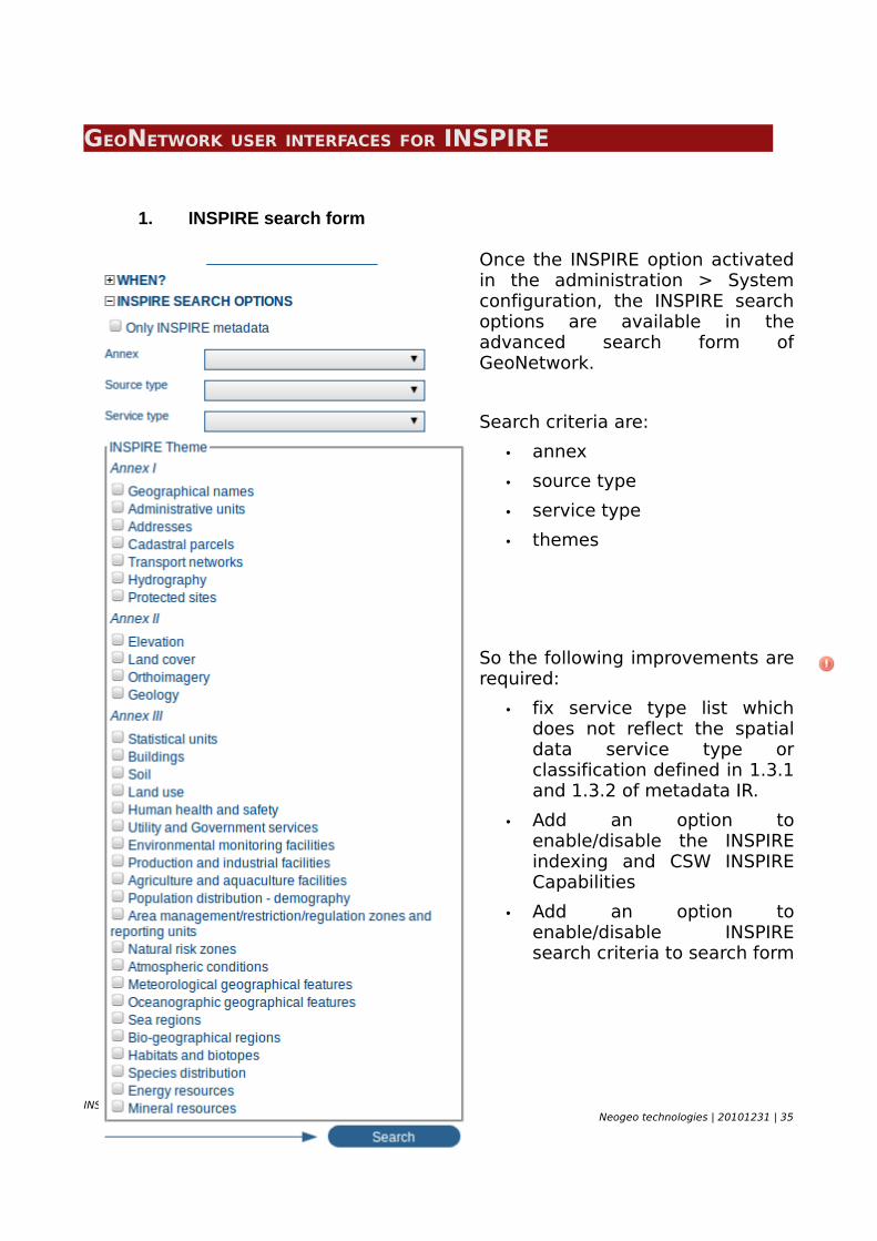
1. INSPIRE search form
Once the INSPIRE option activated in the administration > System configuration, the INSPIRE search options are available in the advanced search form of GeoNetwork.
Search criteria are:
• annex
• source type
• service type
• themes
So the following improvements are required:
• fix service type list which does not reflect the spatial data service type or classification defined in 1.3.1 and 1.3.2 of metadata IR.
• Add an option to enable/disable the INSPIRE indexing and CSW INSPIRE Capabilities
• Add an option to enable/disable INSPIRE search criteria to search form
INSPIRE support in GeoNetwork opensourceNeogeo technologies | 20101231 | 35
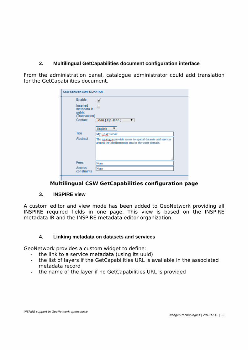
2. Multilingual GetCapabilities document configuration interface
From the administration panel, catalogue administrator could add translation for the GetCapabilities document.
Multilingual CSW GetCapabilities configuration page
3. INSPIRE view
A custom editor and view mode has been added to GeoNetwork providing all INSPIRE required fields in one page. This view is based on the INSPIRE metadata IR and the INSPIRE metadata editor organization.
4. Linking metadata on datasets and services
GeoNetwork provides a custom widget to define:• the link to a service metadata (using its uuid)• the list of layers if the GetCapabilities URL is available in the associated
metadata record• the name of the layer if no GetCapabilities URL is provided
INSPIRE support in GeoNetwork opensourceNeogeo technologies | 20101231 | 36
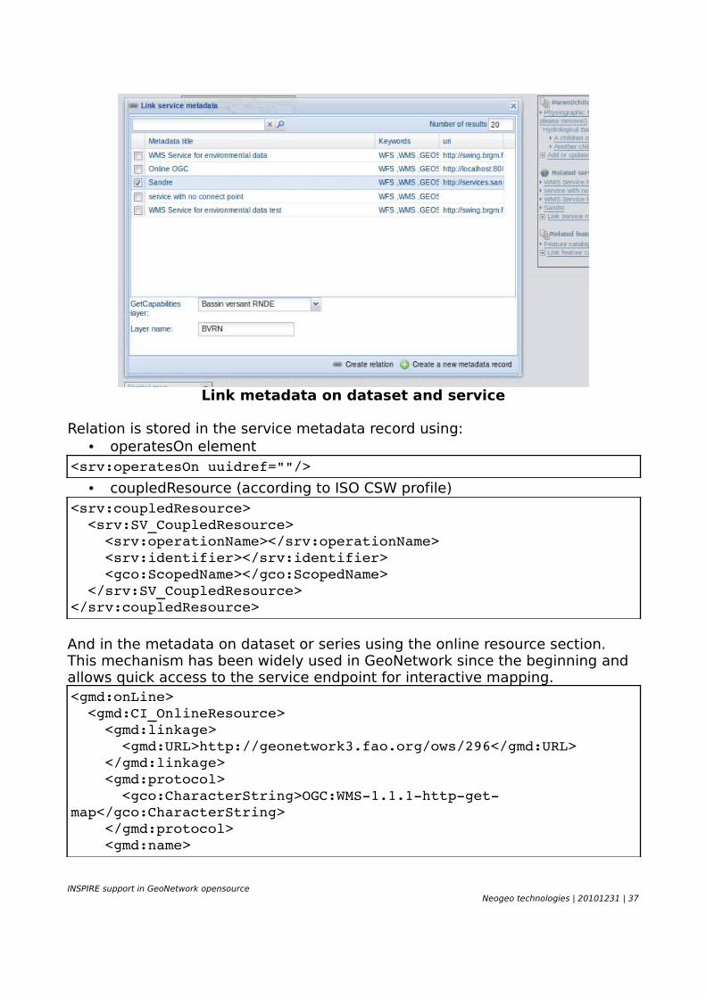
Link metadata on dataset and service
Relation is stored in the service metadata record using:• operatesOn element
<srv:operatesOn uuidref=""/>
• coupledResource (according to ISO CSW profile)<srv:coupledResource> <srv:SV_CoupledResource> <srv:operationName></srv:operationName> <srv:identifier></srv:identifier> <gco:ScopedName></gco:ScopedName> </srv:SV_CoupledResource></srv:coupledResource>
And in the metadata on dataset or series using the online resource section. This mechanism has been widely used in GeoNetwork since the beginning and allows quick access to the service endpoint for interactive mapping.<gmd:onLine> <gmd:CI_OnlineResource> <gmd:linkage> <gmd:URL>http://geonetwork3.fao.org/ows/296</gmd:URL> </gmd:linkage> <gmd:protocol> <gco:CharacterString>OGC:WMS1.1.1httpgetmap</gco:CharacterString> </gmd:protocol> <gmd:name>
INSPIRE support in GeoNetwork opensourceNeogeo technologies | 20101231 | 37
<gco:CharacterString>hydrological_basins</gco:CharacterString> </gmd:name> <gmd:description> <gco:CharacterString>Hydrological basins in Africa</gco:CharacterString> </gmd:description> </gmd:CI_OnlineResource></gmd:onLine>
Only relations between records in the same catalogue are handled. Use of XLink attributes are not supported through the GUI to create relations but an Xlink resolver is available in GeoNetwork if needed.
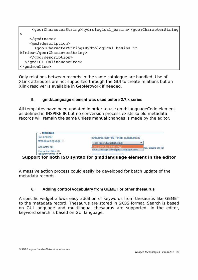
5. gmd:Language element was used before 2.7.x series
All templates have been updated in order to use gmd:LanguageCode element as defined in INSPIRE IR but no conversion process exists so old metadata records will remain the same unless manual changes is made by the editor.
Support for both ISO syntax for gmd:language element in the editor
A massive action process could easily be developed for batch update of the metadata records.
6. Adding control vocabulary from GEMET or other thesaurus
A specific widget allows easy addition of keywords from thesaurus like GEMET to the metadata record. Thesaurus are stored in SKOS format. Search is based on GUI language and multilingual thesaurus are supported. In the editor, keyword search is based on GUI language.
INSPIRE support in GeoNetwork opensourceNeogeo technologies | 20101231 | 38
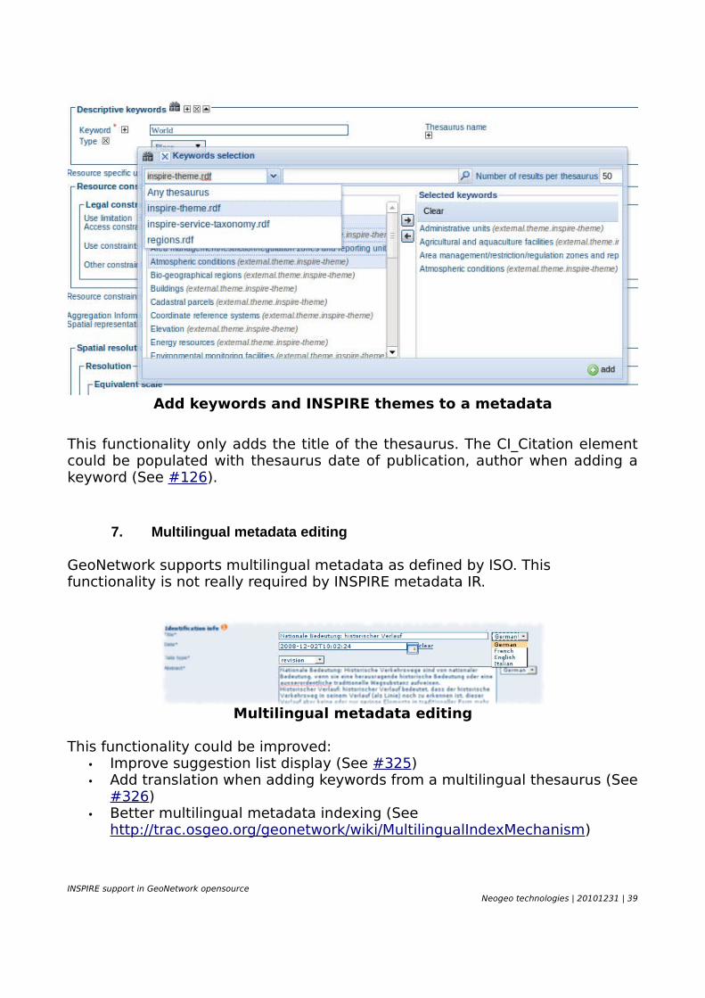
Add keywords and INSPIRE themes to a metadata
This functionality only adds the title of the thesaurus. The CI_Citation element could be populated with thesaurus date of publication, author when adding a keyword (See #126).
7. Multilingual metadata editing
GeoNetwork supports multilingual metadata as defined by ISO. This functionality is not really required by INSPIRE metadata IR.
Multilingual metadata editing
This functionality could be improved:• Improve suggestion list display (See #325)• Add translation when adding keywords from a multilingual thesaurus (See
#326)• Better multilingual metadata indexing (See
http://trac.osgeo.org/geonetwork/wiki/MultilingualIndexMechanism)
INSPIRE support in GeoNetwork opensourceNeogeo technologies | 20101231 | 39
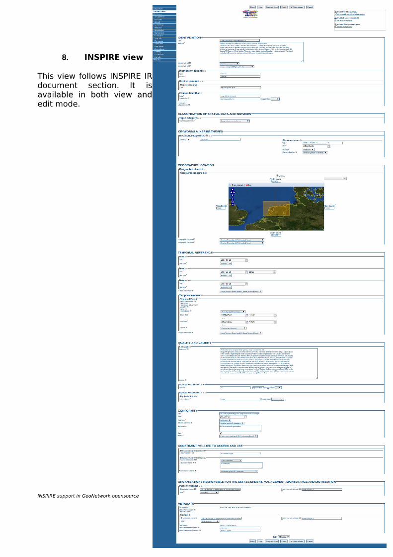
8. INSPIRE view
This view follows INSPIRE IR document section. It is available in both view and edit mode.
INSPIRE support in GeoNetwork opensourceNeogeo technologies | 20101231 | 40
GEONETWORK CONFIGURATION FOR INSPIREThis chapter describes the required steps to turn on all INSPIRE options available in GeoNetwork opensource project.
1. Enable Schematron validation for INSPIRE
After installation, GeoNetwork administrator needs to :
• 2.6.x series : manually copy INSPIRE Schematron from source or to run 'ant inspire' in the Schematrons directory.
• trunk : remove the “.disabled” extension for the INSPIRE rules in the iso19139 schema directory (Fixed by #392)
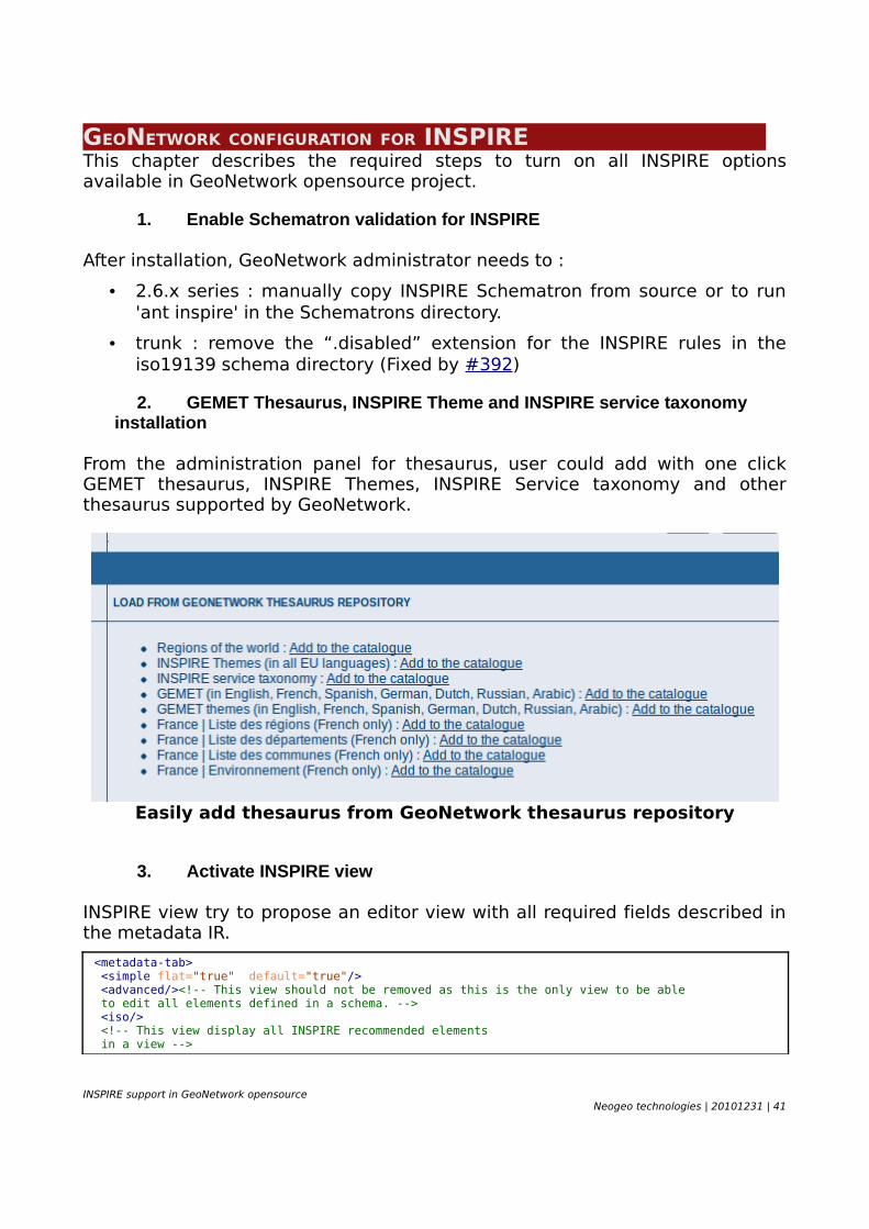
2. GEMET Thesaurus, INSPIRE Theme and INSPIRE service taxonomy installation
From the administration panel for thesaurus, user could add with one click GEMET thesaurus, INSPIRE Themes, INSPIRE Service taxonomy and other thesaurus supported by GeoNetwork.
Easily add thesaurus from GeoNetwork thesaurus repository
3. Activate INSPIRE view
INSPIRE view try to propose an editor view with all required fields described in the metadata IR.
<metadata-tab> <simple flat="true" default="true"/> <advanced/><!-- This view should not be removed as this is the only view to be able to edit all elements defined in a schema. --> <iso/> <!-- This view display all INSPIRE recommended elements in a view -->
INSPIRE support in GeoNetwork opensourceNeogeo technologies | 20101231 | 41
<inspire flat="true"/> <xml/> </metadata-tab>
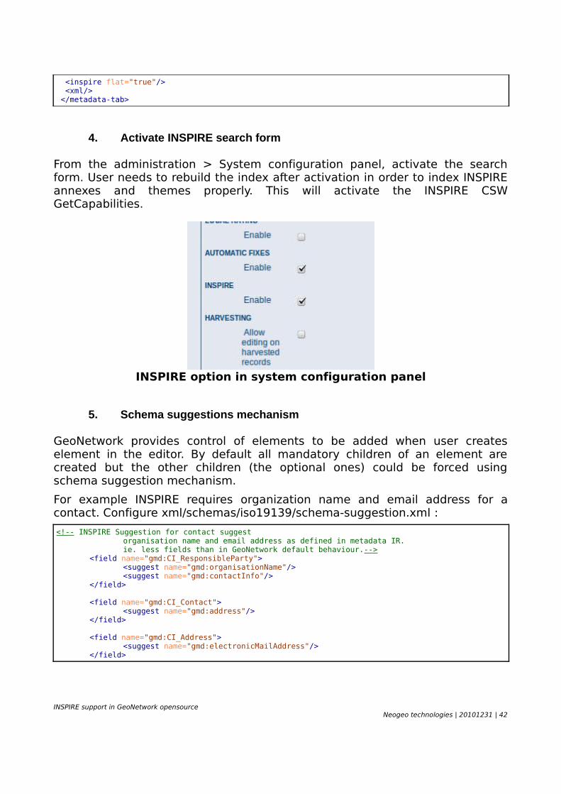
4. Activate INSPIRE search form
From the administration > System configuration panel, activate the search form. User needs to rebuild the index after activation in order to index INSPIRE annexes and themes properly. This will activate the INSPIRE CSW GetCapabilities.
INSPIRE option in system configuration panel
5. Schema suggestions mechanism
GeoNetwork provides control of elements to be added when user creates element in the editor. By default all mandatory children of an element are created but the other children (the optional ones) could be forced using schema suggestion mechanism.
For example INSPIRE requires organization name and email address for a contact. Configure xml/schemas/iso19139/schema-suggestion.xml :
<!-- INSPIRE Suggestion for contact suggest organisation name and email address as defined in metadata IR.ie. less fields than in GeoNetwork default behaviour.-->
<field name="gmd:CI_ResponsibleParty"><suggest name="gmd:organisationName"/><suggest name="gmd:contactInfo"/>
</field>
<field name="gmd:CI_Contact"><suggest name="gmd:address"/>
</field>
<field name="gmd:CI_Address"><suggest name="gmd:electronicMailAddress"/>
</field>
INSPIRE support in GeoNetwork opensourceNeogeo technologies | 20101231 | 42
Distribution format could be change to:
<!-- Add a distribution format / INSPIRE requirement -->
<field name="gmd:distributionInfo"><suggest name="gmd:MD_Distribution"/>
</field><field name="gmd:MD_Distribution">
<suggest name="gmd:distributionFormat"/><suggest name="gmd:transferOptions"/>
</field><field name="gmd:distributionFormat">
<suggest name="gmd:MD_Format"/></field>
That configuration will make editor work easier creating default elements automatically.
6. Temporal reference indexing
By default GeoNetwork does not index date of publication, revision or creation date of the resource as a temporal reference. The metadata IR describe «The metadata shall contain a date of publication, revision or creation of the resource, while in INSPIRE the Temporal Reference can also be expressed through Temporal Extent. » (p7 IR).
If parameter useDateAsTemporalExtent is set to true, then temporal search will include date of publication, revision or creation of the resource.
<!-- If identification creation, publication and revision date should be indexed as a temporal extent information (eg. in INSPIRE metadata implementing rules, those elements are defined as part of the description of the temporal extent). -->
<xsl:variable name="useDateAsTemporalExtent" select="false()"/>
Xml/schemas/iso19139/index-fields.xml
7. Configure suggestion lists for non codelist element
GeoNetwork suggestion list is a mechanism which provides a way to define a list of values for elements which are not codelist elements (eg. gco:CharacterString ). This list is displayed next to the element in edit mode and editor could select one item of the list or manually type a value.
For example, to suggest view, discovery, download, transformation for the service type element, modify the element definition in labels.xml :
<element name="srv:serviceType"><!-- readonly="true" --> <label>Service Type</label> <description>Service type name from a registry of services. For example, the values of the nameSpace and name attributes of GeneralName may be 'OGC' and 'catalogue'</description>
INSPIRE support in GeoNetwork opensourceNeogeo technologies | 20101231 | 43
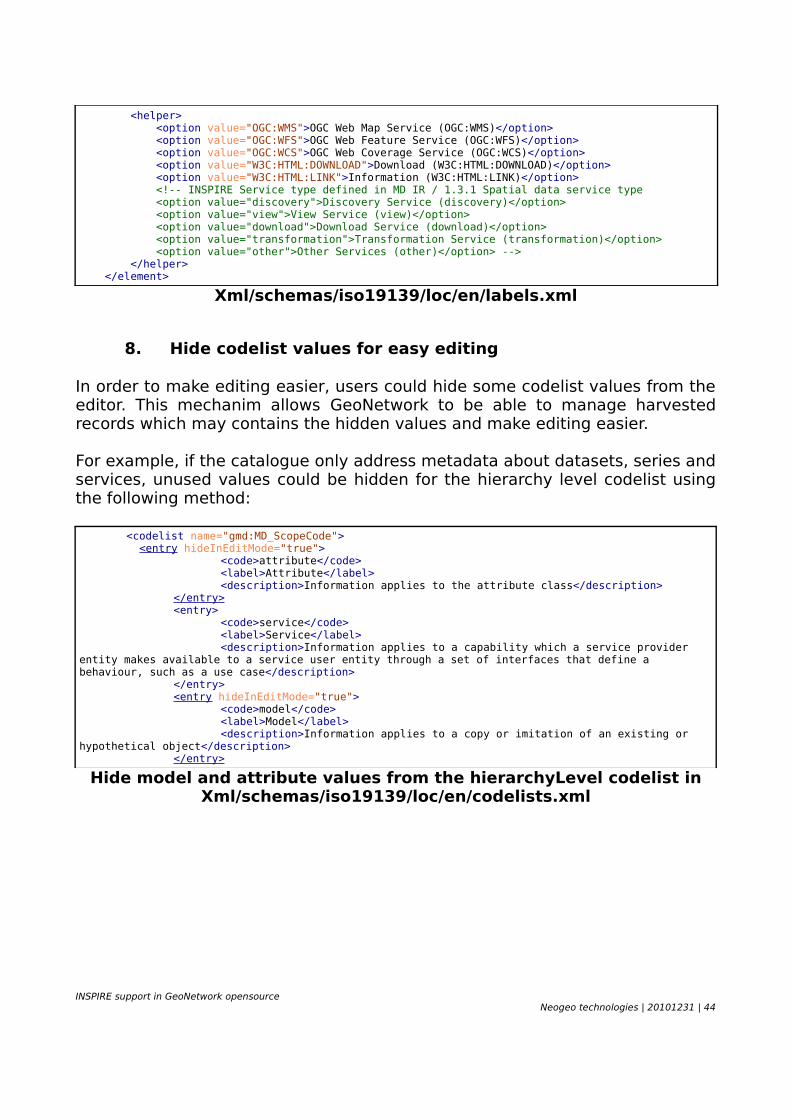
<helper> <option value="OGC:WMS">OGC Web Map Service (OGC:WMS)</option> <option value="OGC:WFS">OGC Web Feature Service (OGC:WFS)</option> <option value="OGC:WCS">OGC Web Coverage Service (OGC:WCS)</option> <option value="W3C:HTML:DOWNLOAD">Download (W3C:HTML:DOWNLOAD)</option> <option value="W3C:HTML:LINK">Information (W3C:HTML:LINK)</option> <!-- INSPIRE Service type defined in MD IR / 1.3.1 Spatial data service type <option value="discovery">Discovery Service (discovery)</option> <option value="view">View Service (view)</option> <option value="download">Download Service (download)</option> <option value="transformation">Transformation Service (transformation)</option> <option value="other">Other Services (other)</option> --> </helper> </element>
Xml/schemas/iso19139/loc/en/labels.xml
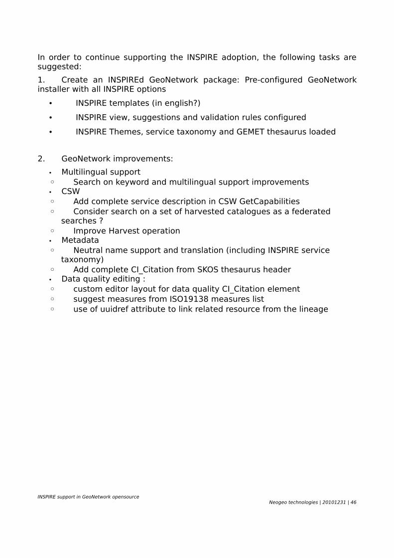
8. Hide codelist values for easy editing
In order to make editing easier, users could hide some codelist values from the editor. This mechanim allows GeoNetwork to be able to manage harvested records which may contains the hidden values and make editing easier.
For example, if the catalogue only address metadata about datasets, series and services, unused values could be hidden for the hierarchy level codelist using the following method:
<codelist name="gmd:MD_ScopeCode"> <entry hideInEditMode="true">
<code>attribute</code><label>Attribute</label><description>Information applies to the attribute class</description>
</entry><entry>
<code>service</code><label>Service</label><description>Information applies to a capability which a service provider
entity makes available to a service user entity through a set of interfaces that define a behaviour, such as a use case</description>
</entry><entry hideInEditMode="true">
<code>model</code><label>Model</label><description>Information applies to a copy or imitation of an existing or
hypothetical object</description></entry>
Hide model and attribute values from the hierarchyLevel codelist in Xml/schemas/iso19139/loc/en/codelists.xml
INSPIRE support in GeoNetwork opensourceNeogeo technologies | 20101231 | 44

CONCLUSIONGeoNetwork opensource supports most of INSPIRE requirements defined in the metadata implementing rules and technical guidance for discovery service. Significant work has been achieved since 2008 by the community supported by lots of organizations accross Europe.
Metadata implementing rules are all covered in current trunk version of GeoNetwork. Only better handling of neutral name has to be done. Therefore, some minor tasks could improved metadata editing user experience by adding sample INSPIRE templates, or deliver a pre-configured editor. Then more work could be done in order to make multilingual support more robust and multilingual search more relevant.
Status against mandatory items of current version 2.12 of the technical guidance for discovery service shows that GeoNetwork does not yet provide all metadata about the service in the capabilities document but already provide the language parameter support. The other main point related to discovey service not supported by GeoNetwork deals with federated search through CSW, which is available in two slighlty different modes:
• Z39.50 distributed search
• harvesting of a federation of spatial resources made available through a common entry point
The analysis of recommendations from the data specification details that :
• Schematron could be used to validate metadata according to data specification requirements
• suggestion mechanism could be added to produce more consistent records using « auto-fixing » task (eg. Set topic category to inlandWater if INSPIRE theme is Hydrography).
• editing the data quality section of GeoNetwork could be improved to make editing task for this section easier.
INSPIRE support in GeoNetwork opensourceNeogeo technologies | 20101231 | 45
In order to continue supporting the INSPIRE adoption, the following tasks are suggested:
1. Create an INSPIREd GeoNetwork package: Pre-configured GeoNetwork installer with all INSPIRE options
• INSPIRE templates (in english?)
• INSPIRE view, suggestions and validation rules configured
• INSPIRE Themes, service taxonomy and GEMET thesaurus loaded
2. GeoNetwork improvements:
• Multilingual support◦ Search on keyword and multilingual support improvements• CSW◦ Add complete service description in CSW GetCapabilities◦ Consider search on a set of harvested catalogues as a federated
searches ?◦ Improve Harvest operation• Metadata◦ Neutral name support and translation (including INSPIRE service
taxonomy)◦ Add complete CI_Citation from SKOS thesaurus header• Data quality editing :◦ custom editor layout for data quality CI_Citation element◦ suggest measures from ISO19138 measures list◦ use of uuidref attribute to link related resource from the lineage
INSPIRE support in GeoNetwork opensourceNeogeo technologies | 20101231 | 46