individual battlefield profiles - national park service battlefield profiles update to the civil war...
TRANSCRIPT

Update to the Civil War Sites Advisory Commission Report on the Nation’s Civil War Battlefields Final DRAFT – State of Missouri 29
Battlefield Profile Glossary
Location County or city in which the battlefield is located. Campaign Name of military campaign of which the battle was part. Campaign names are taken from The War of the Rebellion: a Compilation of the Official Records of the Union and Confederate Armies. Battle Date(s) Day or days upon which the battle took place, as determined by the Civil War Sites Advisory Commission. Principal Commanders Ranking commanders of opposing forces during the battle. Forces Engaged Name or description of largest units engaged during the battle. Results Indicates battle victor or inconclusive outcome. Study Area Acres within the Study Area, as determined by the ABPP, that represent the historic extent of the battle upon the landscape. Potential National Acres of land that retain historic character and may be eligible for Register Lands listing in the National Register of Historic Places, as determined by ABPP. Protected Lands Estimated acreage (based on questionnaires and GIS) of battlefield land that
is in public or private non-profit ownership, or is under permanent protective easement, and is managed specifically for 1) the purposes of maintaining the historic character of the landscape and for preventing future impairment or destruction of the landscape and historic features, or for 2) a conservation purpose and use compatible with the goals of historic landscape preservation.
Publicly Accessible Estimated acres (based on responses to questionnaires) maintained Lands for public visitation. Management Area Name of historic site, park, or other area maintained for resource protection and/or public visitation. Friends Group(s) Name of local advocacy organization(s) that support preservation
activities at/for the battlefield. Preservation Indicates which types of preservation activities have taken place at Activities the battlefield since 1993 (based on responses to questionnaires). Since 1993 Public Indicates which types of interpretation/educational activities have Interpretation taken place at the battlefield since 1993 (based on Since 1993 responses to questionnaires). Condition Statement The ABPP’s assessment of the overall condition of the battlefield’s Study Area (based on field surveys and responses to questionnaires). Historical Designation Notes the most prestigious historical designation the battlefield has received (i.e. national park unit, National Historic Landmark, or National Register of Historic Places).
Individual Battlefield Profiles
Update to the Civil War Sites Advisory Commission Report on the Nation’s Civil War Battlefields Final DRAFT – State of Missouri 30
Belmont (MO009) Location Mississippi County; Hickman County, Kentucky Campaign Operations at the Ohio and Mississippi River Confluence (1861) Battle Date(s) November 7, 1861 Principal Commanders Brigadier General Ulysses S. Grant, Commander Henry A. Walke [US];
Brigadier General Gideon J. Pillow, Brigadier General Frank Cheatham [CS]
Forces Engaged District of Southwest Missouri; USS Lexington and USS Tyler [US]; First
Division, Western Department [CS] Results Inconclusive Study Area 4,502.29 acres (3,136.89 acres in Missouri; 1,365.40 acres in
Kentucky) The revised Study Area represents the Mississippi river’s course as it flowed in
1861 and includes expanded boundaries that incorporate the US naval movements on the river. The ABPP also expanded the Study Area to include the location where Confederate reinforcements crossed the river from Columbus, Kentucky; the fortifications near Columbus known as the “Iron Bluffs;” and the 27th Illinois Infantry’s route of withdrawal to the army’s landing point on the river (the 27
th became separated from the main Union force during
the battle). The ABPP also expanded the Core Area to represent the range of Confederate
guns firing from the “Iron Bluffs” and the range of the guns on board the USS Tyler and the USS Lexington, which provided covering fire for the Federal
retreat.
Potential National 3,660.45 acres (3,128.17 acres in Missouri; 532.28 acres in Kentucky) Register Lands Protected Lands 160.00 acres (in Kentucky) Columbus-Belmont State Park (Kentucky State Parks)
Publicly Accessible Lands 70.00 acres Columbus-Belmont State Park (Kentucky State Parks)
Management Area(s) Columbus-Belmont State Park (Kentucky) Friends Group(s) None Preservation Activities Advocacy Since 1993 Cultural Resource Surveys and Inventories Fundraising Interpretation Projects Land or Development Rights Purchased Legislation Planning Projects Research and Documentation Other Public Interpretation Brochure(s) Since 1993 Driving Tour Living History Maintained Historic Features/Areas Visitor Center

Update to the Civil War Sites Advisory Commission Report on the Nation’s Civil War Battlefields Final DRAFT – State of Missouri 31
Walking Tour/Trails Wayside Exhibits/Signs
Website http://www.parks.ky.gov/findparks/recparks/cb Other
Condition Statement Portions of the landscape have been altered, but most essential
features remain. The Missouri portion of the battlefield is rural and mostly cropland. The Mississippi river has not altered its course much here since the Civil War, which allows for a higher degree of landscape integrity than at battlefields where meandering waterways have wiped out defining features, altered terrain, and confused modern interpretation. There are no known threats to the battlefield on the Missouri side. On the Kentucky side, Kentucky State Parks protects 160 acres, including the Confederate earthworks. Belmont provides an excellent opportunity for comprehensive landscape protection over the long term.
Historical Designation None

Update to the Civil War Sites Advisory Commission Report on the Nation’s Civil War Battlefields Final DRAFT – State of Missouri 32

Update to the Civil War Sites Advisory Commission Report on the Nation’s Civil War Battlefields Final DRAFT – State of Missouri 33
Boonville (MO001) Location Cooper and Howard Counties Campaign Operations to Control Missouri (1861) Battle Date(s) June 17, 1861 Principal Commanders Brigadier General Nathaniel Lyon [US]; Colonel John S. Marmaduke
[CS] Forces Engaged Battery F, 2
nd US Artillery, Company B, 2
nd US Infantry, Two Recruit
Companies, 4th US Artillery, 1
st and 2
nd Regiments Missouri Volunteers
[US]; Missouri State Guard [CS] Results Union victory Study Area 2,405.72 acres
The ABPP modified the 1993 Study Area to add the route of the Federal approach from the Missouri River and the route of the Confederate retreat towards the town of Boonville.
The 1993 Core Area was shortened slightly to represent the actual
location of Camp Bacon. The ABPP also added two new Core Areas. The first represents the location of a Confederate battery along the river that was bombarded by the Union Army transport’s artillery. The second Core Area represents the Confederate camp on the outskirts of town that also received fire from the transport’s artillery.
Potential National 1,899.46 acres Register Lands Protected Lands 10.55 acres
US Fish and Wildlife Service, fee simple
Publicly Accessible Lands 10.55 acres US Fish and Wildlife Service, Big Muddy National Fish and Wildlife Refuge
Management Area(s) Big Muddy National Fish and Wildlife Refuge Friends Group(s) None Preservation Activities Advocacy Since 1993 Cultural Resource Surveys and Inventories Fundraising Interpretation Projects Land or Development Rights Purchased Legislation
Planning Projects Research and Documentation
Public Interpretation Brochure(s) Since 1993 Driving Tour Living History Maintained Historic Features/Areas Visitor Center Walking Tour/Trails Wayside Exhibits/Signs
Website Other

Update to the Civil War Sites Advisory Commission Report on the Nation’s Civil War Battlefields Final DRAFT – State of Missouri 34
Condition Statement Portions of the landscape have been altered, but most essential
features remain. Aerial photographs indicate new, large lot home construction within the easternmost Core Area and to the south and west of the Study Area along SR 98 in a water service district. No land is protected at this battlefield. Further subdivision of rural land poses a serious long-term threat to the historic landscape.
Historical Designation None

Update to the Civil War Sites Advisory Commission Report on the Nation’s Civil War Battlefields Final DRAFT – State of Missouri 35
Update to the Civil War Sites Advisory Commission Report on the Nation’s Civil War Battlefields Final DRAFT – State of Missouri 36
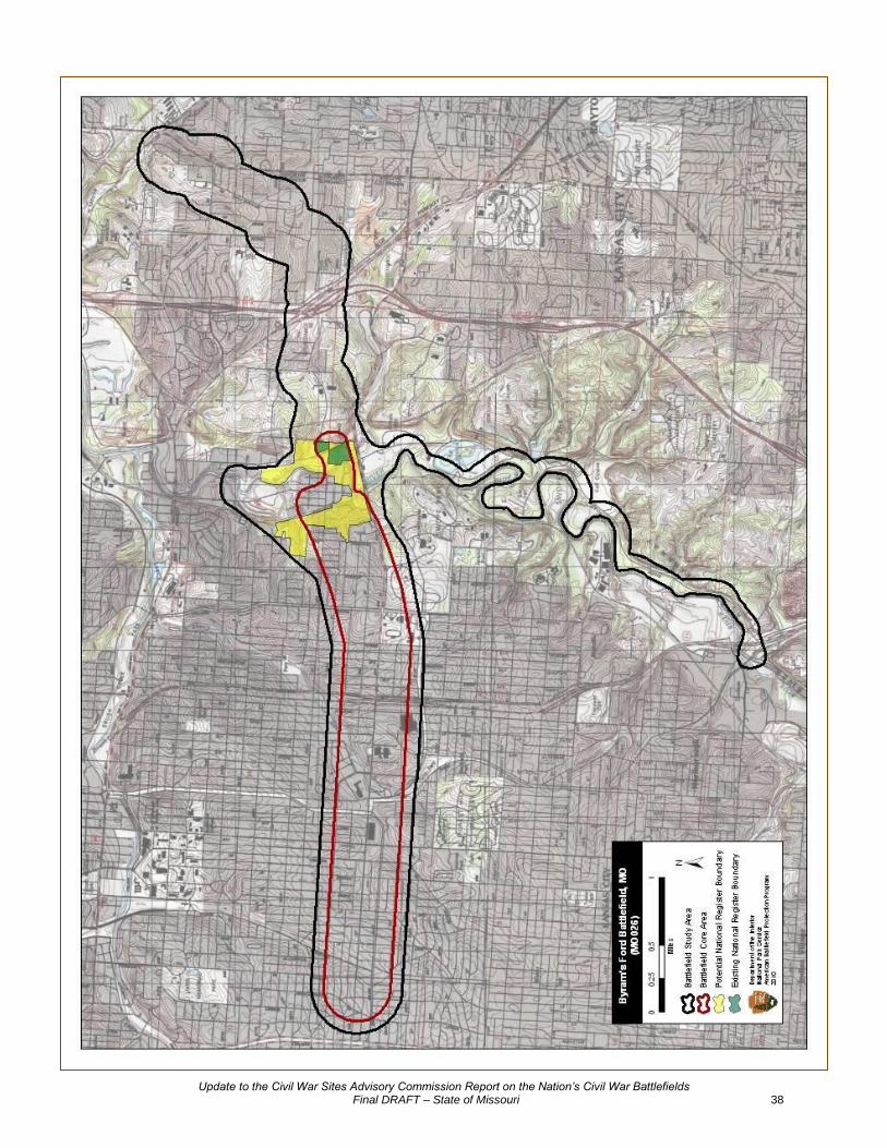
Byram’s Ford (MO026) Location Jackson County Campaign Price’s Missouri Expedition (1864) Battle Date(s) October 22, 1864 Principal Commanders Colonel Charles R. Jennison, Colonel Thomas Moonlight [US];
Brigadier General Joseph Shelby [CS] Forces Engaged 1
st Cavalry Brigade, Army of the Border; 2
nd Brigade, Army of the Border
[US]; Shelby’s Division, Army of Missouri [CS] Results Union victory Study Area 3,353.35 acres
The 1993 Study Area and Core Area did not accurately reflect the full extent of the battlefield landscape. The ABPP redrew the Study Area to include: 1) the Confederate approach from the east, 2) Confederate movements along the Big Blue River (these movements caused Union forces to eventually withdraw from the Byram's Ford area), 3) fighting to the immediate east and west of Byram's Ford, 4) the Confederate flanking movement from the north, and 5) the fighting retreat of Union forces west toward the Missouri-Kansas state line.
The Core Area includes the locations of frontal assaults on Byram's Ford,
the left flank attack by Confederate forces on the Union lines, and the organized fighting withdrawal from the Byram's Ford area to within a quarter mile of the Missouri-Kansas state line.
Potential National 207.25 acres Register Lands Protected Lands 126.37 acres
Kansas City Parks and Recreation, 122.37 acres, fee simple Monett Battle of Westport Fund, 4.00 acres, fee simple
Publicly Accessible Lands 376.37 acres
Kansas City Parks Department, Big Blue Battlefield Park, 122.37 acres Kansas City Parks and Recreation, Swope Park, 250 acres Monett Battle of Westport Fund, 4.00 acres
Management Area(s) Big Blue Battlefield Park Swope Park Friends Group(s) Monnett Battle of Westport Fund, inc. (1975)
http://http://www.battleofwestport.org Preservation Activities Advocacy Since 1993 Cultural Resource Surveys and Inventories Fundraising Interpretation Projects Land or Development Rights Purchased Legislation Planning Projects
Research and Documentation Public Interpretation Brochure(s) Since 1993 Driving Tour
Living History

Update to the Civil War Sites Advisory Commission Report on the Nation’s Civil War Battlefields Final DRAFT – State of Missouri 37
Maintained Historic Features/Areas Visitor Center Walking Tour/Trails Wayside Exhibits/Signs Website http://http://www.battleofwestport.org/
http://www.kcmo.org/CKCMO/Depts/ParksandRecreation/ SwopePark/index.htm
Other Video - Saving Kansas City’s Battlefield Initiative
Condition Statement The landscape of the battlefield has been severely altered since the
period of significance. The growth of Kansas City has subsumed the battlefield and, with the exception of lands within the easternmost portion of the Core Area, the majority of Byram’s Ford is now an urban landscape. Kansas City Parks and Recreation preserves part of the battlefield as the Big Blue Battlefield Park and has been working with the Monnett Battle of Westport Fund, Inc. on acquisition, preservation and interpretive opportunities for the battlefield, concentrating on the Park and battlefield lands between the Big Blue River and Elmwood Avenue. While an archeological survey was completed on a portion of the battlefield in 1997, future archeological surveys should be undertaken on the remaining open space to determine if and where defining features (such as road traces) and battle signatures survive.
Historical Designation National Register of Historic Places (Byram’s Ford Historic District, 1989)
Update to the Civil War Sites Advisory Commission Report on the Nation’s Civil War Battlefields Final DRAFT – State of Missouri 38

Update to the Civil War Sites Advisory Commission Report on the Nation’s Civil War Battlefields Final DRAFT – State of Missouri 39
Cape Girardeau (MO020) Location Cape Girardeau County; Alexander County, Illinois Campaign Marmaduke’s Second Expedition into Missouri (1863) Battle Date(s) April 26, 1863 Principal Commanders Brigadier General John McNeil [US]; Brigadier General John S.
Marmaduke [CS] Forces Engaged Cape Girardeau Garrison [US]; 4
th Division, First Corps, Trans-
Mississippi Department [CS] Results Union victory Study Area 6,292.22 acres (5,276.9 acres in Missouri; 1,015.33acres in Illinois) The revised 1993 Study Area includes the approach route of Union re-
enforcements traveling along the Mississippi River and the Confederate approach routes along the Jackson, Perryville, and Bloomfield Roads. The exact route of the Confederate retreat from Jackson Road towards Bloomfield is not known and, for that reason, was not added. The ABPP reduced the 1993 Core Area boundary to areas of skirmishing on Jackson Road and the fields of fire of the multiple batteries engaged.
Potential National 0.00 acres Register Lands Protected Lands 3.00 acres
City of Cape Girardeau, fee simple
Publicly Accessible Lands 3.00 acres
City of Cape Girardeau, Fort D Historic Site
Management Area(s) Fort D Historic Site Friends Group(s) Friends of Fort D/Cape Girardeau Parks Development Foundation (1993) Preservation Activities Advocacy Since 1993 Cultural Resource Surveys and Inventories Fundraising Interpretation Projects Land or Development Rights Purchased Legislation Planning Projects Research and Documentation
Public Interpretation Brochure(s) Since 1993 Driving Tour
Living History Maintained Historic Features/Areas
Visitor Center Walking Tour/Trails Wayside Exhibits/Signs Website
Other

Update to the Civil War Sites Advisory Commission Report on the Nation’s Civil War Battlefields Final DRAFT – State of Missouri 40
Condition Statement The landscape and terrain of this battlefield have been altered beyond recognition since the period of significance. The City of Cape Girardeau has overwhelmed the battlefield and it is now an urban landscape. Commemorative and interpretive opportunities exist, however, especially at the Fort D Historic Site.
Historical Designation None

Update to the Civil War Sites Advisory Commission Report on the Nation’s Civil War Battlefields Final DRAFT – State of Missouri 41

Update to the Civil War Sites Advisory Commission Report on the Nation’s Civil War Battlefields Final DRAFT – State of Missouri 42
Carthage (MO002) Location Jasper County Campaign Operations to Control Missouri (1861) Battle Date(s) July 5, 1861 Principal Commanders Colonel Franz Sigel [US]; Brigadier General James S. Rains [CS] Forces Engaged Second Brigade Missouri Volunteers [US]; 2
nd Division Missouri State
Guard [CS] Results Confederate victory Study Area 9,209.83 acres The ABPP expanded the 1993 Study Area in the north to include the
Confederate and Union lines above Double Trouble Creek. The Study Area boundary was also narrowed slightly to account for the fact that most of the action associated with this running engagement closely followed the roads. The 1993 Core Areas have been adjusted to reflect the ranges of artillery employed during this battle.
In addition to the 1993 Core Areas, two new Core Areas were added. The
first is located north of Double Trouble Creek and represents the battle’s opening artillery duel. The second was added at the southern end of the battlefield to account for fighting within Carthage and to the east of town.
Potential National 7,539.72 acres Register Lands Protected Lands 7.40 acres
Missouri Department of Natural Resources, fee simple
Publicly Accessible Lands 7.40 acres
Missouri Department of Natural Resources, Battle of Carthage State Historic Site
Management Area(s) Battle of Carthage State Historic Site Friends Group(s) None Preservation Activities Advocacy Since 1993 Cultural Resource Surveys and Inventories Fundraising Interpretation Projects Land or Development Rights Purchased Legislation Planning Projects Research and Documentation
Other Public Interpretation Brochure(s) Since 1993 Driving Tour
Living History Maintained Historic Features/Areas Visitor Center Walking Tour/Trails Wayside Exhibits/Signs Website
http://www.mostateparks.com/carthage.htm

Update to the Civil War Sites Advisory Commission Report on the Nation’s Civil War Battlefields Final DRAFT – State of Missouri 43
Other Condition Statement Portions of the landscape have been altered, but most essential
features remain. The growth of the City of Carthage has destroyed the southern portion of the battlefield, but much of the battlefield to the north of the city retains integrity. The Battle of Carthage State Historic Site protects 7.40 acres on the eastern edge of the city, but the land is isolated from the rest of the battlefield. North of the city, active mining continues to destroy Core Area land, as has the recent construction of the US 71 bypass through the portions of the battlefield at Kendricktown. Ordnuff Hill, where Sigel's artillery fired on Rains' division to slow its advance and allow the Federal wagons time to cross the Spring River at Walker's Ford, has been destroyed by mining operations (the hill is now called Quarry Hill). Surviving land within this Core Area should be targeted for immediate preservation. Long-term preservation efforts should focus on protecting the battlefield landscape north of Kendricktown that retains good integrity.
Historical Designation None

Update to the Civil War Sites Advisory Commission Report on the Nation’s Civil War Battlefields Final DRAFT – State of Missouri 44

Update to the Civil War Sites Advisory Commission Report on the Nation’s Civil War Battlefields Final DRAFT – State of Missouri 45
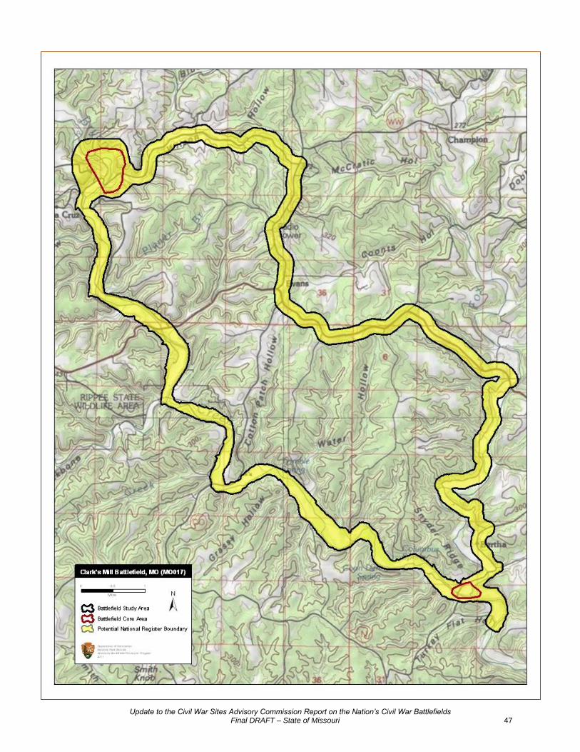
Clark’s Mill (MO017) Location Douglas County Campaign Operations North of Boston Mountains (1862) Battle Date(s) November 7, 1862 Principal Commanders Captain Hiram E. Barstow [US]; Colonel John Q. Burbridge [CS] Forces Engaged Company C and M, 10
th Illinois Cavalry and Company H, Missouri
Home Guard Militia [US]; 3rd
, 4th, and 8
th Missouri Cavalry,
Marmaduke’s Division, Army of the West [CS] Results Confederate victory Study Area 4,306.18 acres The CWSAC did not establish complete Study and Core Areas for Clark’s
Mill in 1993. The newly drawn Study Area includes the Confederate advance along the creek bed of Bryant's Creek, and the Union retreat from Bryant's Creek along the Old Vera Cruz Road to Vera Cruz and the blockhouses at Clark's Mill.
The lower Core Area represents the drive of the Confederate vanguard
south of Vera Cruz along Bryant's Creek. The upper Core Area represents the artillery duel and skirmishing around Clark's Mill itself.
Potential National 4,306.18 acres Register Lands Protected Lands 0.00 acres Publicly Accessible Lands 0.00 acres Management Area(s) None Friends Group(s) None Preservation Activities Advocacy Since 1993 Cultural Resource Surveys and Inventories Fundraising Interpretation Projects Land or Development Rights Purchased Legislation Planning Projects Research and Documentation
Other
Public Interpretation Brochure(s) Since 1993 Driving Tour
Living History Maintained Historic Features/Areas Visitor Center Walking Tour/Trails Wayside Exhibits/Signs Website
Other Condition Statement Land use is little changed since the time of battle. The Clark’s Mill is
located in rural Douglas County. All of the land within the battlefield boundary is privately owned. There are no known land use threats to

Update to the Civil War Sites Advisory Commission Report on the Nation’s Civil War Battlefields Final DRAFT – State of Missouri 46
the battlefield at this time. Clark’s Mill presents an excellent opportunity for comprehensive battlefield preservation over the long term.
Historical Designation None
Update to the Civil War Sites Advisory Commission Report on the Nation’s Civil War Battlefields Final DRAFT – State of Missouri 47

Update to the Civil War Sites Advisory Commission Report on the Nation’s Civil War Battlefields Final DRAFT – State of Missouri 48
Dry Wood Creek (MO005) Location Vernon County Campaign Operations to Control Missouri (1861) Battle Date(s) September 2, 1861 Principal Commanders Brigadier General James M. Lane [US]; Brigadier General Sterling
Price [CS] Forces Engaged Kansas Brigade [US]; Missouri State Guard [CS] Results Confederate victory Study Area 2,927.57 acres
The 1993 Study Area for Dry Wood Creek originally included two separated parts. Based on new research, the ABPP determined that no fighting associated with this battle occurred in the eastern segment. Thus, that portion of the Study Area was removed. The ABPP also adjusted the Study Area to take in the breadth of the creek, a defining feature of the battlefield. The Core Area was reduced slightly to more accurately follow topographic features.
Potential National 2,927.57 acres Register Lands Protected Lands 0.00 acres Publicly Accessible Lands 0.00 acres Management Area(s) None Friends Group(s) None Preservation Activities Advocacy Since 1993 Cultural Resource Surveys and Inventories Fundraising Interpretation Projects Land or Development Rights Purchased Legislation Planning Projects Research and Documentation
Other
Public Interpretation Brochure(s) Since 1993 Driving Tour
Living History Maintained Historic Features/Areas Visitor Center Walking Tour/Trails Wayside Exhibits/Signs Website
Other Condition Statement Land use is little changed since the time of battle. All of the land
within the battlefield boundary is privately owned. The land is mostly in crop production, interspersed with woodlands. Scattered farm complexes dot the landscape. There are no known land use threats to the battlefield at this time. Dry Wood Creek presents an excellent

Update to the Civil War Sites Advisory Commission Report on the Nation’s Civil War Battlefields Final DRAFT – State of Missouri 49
opportunity for comprehensive battlefield preservation over the long term.
Historical Designation None

Update to the Civil War Sites Advisory Commission Report on the Nation’s Civil War Battlefields Final DRAFT – State of Missouri 50
Update to the Civil War Sites Advisory Commission Report on the Nation’s Civil War Battlefields Final DRAFT – State of Missouri 51
Fort Davidson (MO021) Location Iron County Campaign Price’s Missouri Expedition (1864) Battle Date(s) September 26-27, 1864 Principal Commanders Brigadier General Thomas Ewing, Jr. [US]; Major General Sterling
Price [CS] Forces Engaged Detachment from the 14
th Iowa Infantry; Garrison consisting of Battery
H, 2nd
Missouri Light Artillery and companies from the 47th Missouri
Infantry, 50th Missouri Infantry, 1
st Missouri State Militia Infantry, 2
nd
Missouri State Militia Cavalry, and 3rd
Missouri State Militia Cavalry [US]; Army of Missouri [CS]
Results Union victory Study Area 4,556.30 acres
The ABPP expanded the 1993 Study Area boundary significantly. The larger Study Area encompasses the initial Confederate approach from the east to the “Shut-ins;” the site of the Confederate encampment on the southern side of Shepherd Mountain; Confederate troop movements on and around Shepherd Mountain; Federal troop movements on Pilot Knob; Confederate troop movements above Fort Davidson (made in an attempt to attack Fort Davidson from the north); the sites of the two Confederate encampments north of the town of Pilot Knob between which withdrawing Union troops had to pass under cover of darkness; and the Union route of withdrawal from the fort to the northwest.
Because the combatants fought over the same middle ground repeatedly
during the two-day battle, the two original CWSAC Core Areas were expanded and merged to create a single Core Area. This new Core Area encompasses areas where fighting took place on either, or both, September 26 and 27. It includes the initial point of contact at the “Shut-ins”and areas of subsequent engagement in Arcadia and Ironton on the 26
th, and the areas of fighting in the gap, on the mountains, and around
Fort Davidson on the 27th.
Potential National 1,760.90 acres Register Lands Protected Lands 1,111.94 acres
City of Ironton, 600.00 acres, fee simple USDA Forest Service, 334.48 acres, fee simple US Fish and Wildlife Service, 100.27 acres, fee simple Missouri Department of Natural Resources, 77.19 acres, fee simple
Publicly Accessible Lands 1,011.67 acres
City of Ironton, Shepherd Mountain Natural Area Park, 600.00 acres USDA Forest Service, Mark Twain National Forest, 334.48 acres Missouri Department of Natural Resources, Fort Davidson State Historic
Site, 77.19 acres
Management Area(s) Fort Davidson State Historic Site Mark Twain National Forest Pilot Knob National Wildlife Refuge Shepherd Mountain Natural Area Park Friends Group(s) Friends of Fort Davidson
http://http://www.mostateparks.com/ftdavidson/friends.htm

Update to the Civil War Sites Advisory Commission Report on the Nation’s Civil War Battlefields Final DRAFT – State of Missouri 52
Preservation Activities Advocacy Since 1993 Cultural Resource Surveys and Inventories Fundraising Interpretation Projects Land or Development Rights Purchased Legislation Ironton revenue bond
Planning Projects Research and Documentation
Other
Public Interpretation Brochure(s) Since 1993 Driving Tour
Living History Maintained Historic Features/Areas Visitor Center Walking Tour/Trails Wayside Exhibits/Signs Website
http://http://www.mostateparks.com/ftdavidson.htm Other DVD, Library
Condition Statement Much of the landscape has been altered and fragmented, leaving
some essential features. The battlefield landscape has been severely altered due the growth of the towns of Pilot Knob, Ironton, and Acadia. The two most prominent topographical features to survive are Pilot Knob and Shepherd Mountain. Pilot Knob is permanently protected by the US Fish and Wildlife Service. Shepherd Mountain is owned by the City of Ironton. In this case, however, the city’s ownership does not imply perpetual protection. In its March 2005 Conceptual Development Plan, the Fort Davidson State Historic Site stated that, “the City of Ironton maintains a lease-purchase agreement that designates Shepherd Mountain as a local natural area park; however, the phrase ‘natural area park’ is not clearly defined in the agreement language nor is a list provided of acceptable or unacceptable types of development. The division would like to ensure preservation of Shepherd Mountain’s scenic vista. For this reason, the division proposes to enter a scenic easement agreement with the City of Ironton to protect the mountain from residential and commercial expansion, while providing the opportunity for potential trail and overlook development.” If a perpetual easement can be placed on the city’s land, then nearly all of the surviving historic landscape will be secure from development in perpetuity.
Historical Designation National Register of Historic Places (Fort Davidson, 1970)

Update to the Civil War Sites Advisory Commission Report on the Nation’s Civil War Battlefields Final DRAFT – State of Missouri 53

Update to the Civil War Sites Advisory Commission Report on the Nation’s Civil War Battlefields Final DRAFT – State of Missouri 54
Fredericktown (MO007) Location Madison County Campaign Operations to Control Missouri (1861) Battle Date(s) October 21, 1861 Principal Commanders Colonel J. B. Plummer [US]; Brigadier General Meriwether “Jeff”
Thompson [CS] Forces Engaged 17
th, 20
th, 21
st, and 33
rd Illinois Volunteer Infantry, 11
th Missouri
Infantry, five companies of the 1st Indiana Cavalry, Stewart’s
Independent Cavalry Company, Benton Hussars Cavalry Battalion, White’s section of Battery B, 1
st Illinois Light Artillery, Battery A, 1
st
Missouri Light Artillery [US]; Missouri State Guard [CS] Results Union victory Study Area 1,105.80 acres
The 1993 Study Area was revised to include the routes of approach used by the two columns of Union troops (one from Cape Girardeau and the other from Pilot Knob) converging to the north of the town of Fredericktown. The ABPP also included the route taken by the retreating Confederate and pursuing Federal troops to the south. The Study Area was enlarged around the Core Area to the west to include the area where the Union line wheeled against Thompson’s force in the cornfield opposite the Union left.
Potential National 447.52 acres Register Lands Protected Lands 3.00 acres Foundation for Historic Preservation, fee simple Publicly Accessible Lands 3.00 acres
Foundation for Historic Preservation, Battle of Fredericktown Civil War Museum
Management Area(s) Battle of Fredericktown Civil War Museum Friends Group(s) The Foundation for Historic Preservation Preservation Activities Advocacy Since 1993 Cultural Resource Surveys and Inventories Fundraising Interpretation Projects Land or Development Rights Purchased Legislation Planning Projects Research and Documentation
Other
Public Interpretation Brochure(s) Since 1993 Driving Tour
Living History Maintained Historic Features/Areas Visitor Center Walking Tour/Trails Wayside Exhibits/Signs Website

Update to the Civil War Sites Advisory Commission Report on the Nation’s Civil War Battlefields Final DRAFT – State of Missouri 55
http://www.fhphistory.org/
Other Condition Statement Portions of landscape have been altered, but most essential features
remain. The battlefield landscape has been altered due to the growth of Fredericktown. The southern portion of the battlefield has been compromised by residential development around Millcreek and the construction of numerous roads since the Civil War, most recently the new route of the four-lane US 67 and a diamond interchange just south of Millcreek. The 447 acres of battlefield that retain integrity will likely experience development pressure within the next five years, especially along US 67 Business between Fredericktown and Millcreek. Protection efforts are needed immediately to preserve the last cohesive portion of the Core Area and surrounding landscape.
Historical Designation None

Update to the Civil War Sites Advisory Commission Report on the Nation’s Civil War Battlefields Final DRAFT – State of Missouri 56

Update to the Civil War Sites Advisory Commission Report on the Nation’s Civil War Battlefields Final DRAFT – State of Missouri 57
Glasgow (MO022) Location Howard and Saline Counties Campaign Price’s Missouri Expedition (1864) Battle Date(s) October 15, 1864 Principal Commanders Colonel Chester Hardin, Jr. [US]; Brigadier General John B. Clark Jr.
and Brigadier General Joseph O. Shelby [CS] Forces Engaged Garrison consisting of parts of the 43
rd Missouri Infantry, 4
th
Provisional Regiment Enrolled Missouri Militia, 9th Cavalry Missouri
State Militia, 13th Missouri Cavalry, and two companies of citizen
militia [US]; Marmaduke’s Brigade, Marmaduke’s Division, and Jackman’s Brigade and Collins’ Missouri Battery, Shelby’s Division, Army of Missouri [CS]
Results Confederate victory Study Area 1,769.38 acres
Although the battlefield was surveyed in 1993, the CWSAC did not delineate a Study Area or a Core Area for Glasgow. The ABPP’s new Study Area includes 1) the location of Shelby’s battery on the west side of the Missouri River, 2) Clark’s approach from the south (starting from the position where the Confederates first heard Shelby's guns shelling the town), 3) the main engagement area south of the town, 4) areas of troop movement east and north of town, and 5) the cavalry engagement north of town.
Two Core Areas have been identified. The larger Core Area represents
the main area of fighting, which includes the Confederate line of battle and batteries to the south, the fields of fighting to the south and east of the town, and locations where fighting took place within the town itself. This Core Area extends to the west to include the location of Shelby's guns. The second, smaller Core Area represents the location where elements of Hardin’s cavalry defended the northern approach into the town of Glasgow from attacking Confederate horsemen commanded by Colonel Robert Lawther.
Potential National 710.40 acres Register Lands Protected Lands 0.00 acres Publicly Accessible Lands 7.79 acres
Missouri Department of Conservation, Stump Island Recreation Park
Management Area(s) Stump Island Recreation Park Friends Group(s) None Preservation Activities Advocacy Since 1993 Cultural Resource Surveys and Inventories Fundraising Interpretation Projects Land or Development Rights Purchased Legislation Planning Projects Research and Documentation
Other

Update to the Civil War Sites Advisory Commission Report on the Nation’s Civil War Battlefields Final DRAFT – State of Missouri 58
Public Interpretation Brochure(s) Since 1993 Driving Tour
Living History Maintained Historic Features/Areas Visitor Center Walking Tour/Trails Wayside Exhibits/Signs Website
Other Condition Statement Much of the landscape has been altered and fragmented, leaving
some essential features. Only land to the south of the City of Glasgow survives with integrity. Conversion of farmland for industrial development south of Gregg's Creek continues to destroy what little Core Area terrain survives. Immediate protection efforts are needed to save the last Core Area parcels.
Historical Designation None

Update to the Civil War Sites Advisory Commission Report on the Nation’s Civil War Battlefields Final DRAFT – State of Missouri 59
Update to the Civil War Sites Advisory Commission Report on the Nation’s Civil War Battlefields Final DRAFT – State of Missouri 60
Hartville (MO019) Location Wright and Webster Counties Campaign Marmaduke’s First Expedition into Missouri (1862-1863) Battle Date(s) January 9-11, 1863 Principal Commanders Colonel Samuel Merrill [US]; Brigadier General John S. Marmaduke
[CS] Forces Engaged Elements of the 3
rd Iowa Cavalry, 21
st Iowa Infantry, 99
th Illinois
Infantry, 3rd
Missouri Cavalry, and a section of Battery L, 2nd
Missouri Light Artillery [US]; 4
th Division, First Corps, Trans-Mississippi
Department [CS] Results Confederate victory Study Area 7,654.60 acres
The ABPP revised the 1993 Study Area and extended the Confederate approach route to Marshville where Porter and Marmaduke's forces met prior to moving east. The Confederate flanking maneuver around Merrill's position at Wood's Fork, the Confederate route of retreat toward Houston, and the Union route of retreat towards Lebanon were also added to the Study Area.
The ABPP added a new Core Area at Wood's Fork where Federal and
Confederate forces first clashed. The Core Area at Hartsville was adjusted slightly to better represent the range of artillery used by both forces.
Potential National 4,537.45 acres Register Lands Protected Lands 88.40 acres
Missouri Department of Conservation, fee simple
Publicly Accessible Lands 88.40 acres Missouri Department of Conservation, Odin Access, 75.18 acres Missouri Department of Conservation, Camp Branch Access, 13.22 acres Management Area(s) None Friends Group(s) None Preservation Activities Advocacy Since 1993 Cultural Resource Surveys and Inventories Fundraising Interpretation Projects Land or Development Rights Purchased Legislation Planning Projects Research and Documentation
Other Public Interpretation Brochure(s) Since 1993 Driving Tour
Living History Maintained Historic Features/Areas Visitor Center Walking Tour/Trails
Update to the Civil War Sites Advisory Commission Report on the Nation’s Civil War Battlefields Final DRAFT – State of Missouri 61
Wayside Exhibits/Signs Website
Other Granite monument
Condition Statement Much of the landscape has been altered and fragmented, leaving
some essential features. Growth around Hartville is pushing out to the west and south, bringing residential and commercial development along State Routes 38 and 5. Only the eastern portion of the Core Area at Hartville retains integrity. The entire Core Area at the rural crossroads at Odin retains integrity. With the exception of continued growth around Hartville and along roadways throughout the Study Area, there are no specific threats to the remaining battlefield landscape.
Historical Designation None

Update to the Civil War Sites Advisory Commission Report on the Nation’s Civil War Battlefields Final DRAFT – State of Missouri 62

Update to the Civil War Sites Advisory Commission Report on the Nation’s Civil War Battlefields Final DRAFT – State of Missouri 63
Independence I (MO014) Location Jackson County Campaign Operations North of Boston Mountains (1862) Battle Date(s) August 11, 1862 Principal Commanders Lieutenant Colonel James T. Buel [US]; Colonel John T. Hughes and
Colonel Gideon W. Thompson [CS] Forces Engaged Independence Garrison [US]; Confederate Partisans and recruits
under Hughes, Hays and Quantrill [CS] Results Confederate victory Study Area 591.86 acres
The ABPP adjusted the 1993 Study Area to more accurately align it with the road used by Confederate forces to approach the center of town (the modern Spring Road), and Walnut Road and Lexington Road, which were used by Confederate forces to attack the Union camp on the western edge of town.
The northern Core Area was adjusted to include the locations of fighting
around the courthouse square, the bank and barracks buildings used by Federal forces, and the Independence Jail used by the Provost Marshall. The second Core Area represents the location of the Federal camp on the western edge of town that was assaulted by a portion of the Confederate column.
Potential National 0.00 acres Register Lands Protected Lands 0.00 acres Publicly Accessible Lands 0.00 acres Management Area(s) None Friends Group(s) None Preservation Activities Advocacy Since 1993 Cultural Resource Surveys and Inventories Fundraising Interpretation Projects Land or Development Rights Purchased Legislation Planning Projects Research and Documentation
Other
Public Interpretation Brochure(s) Since 1993 Driving Tour
Living History Maintained Historic Features/Areas Visitor Center Walking Tour/Trails Wayside Exhibits/Signs Website
Other

Update to the Civil War Sites Advisory Commission Report on the Nation’s Civil War Battlefields Final DRAFT – State of Missouri 64
Condition Statement The landscape and terrain of this battlefield have been altered beyond
recognition since the period of significance. The City of Independence has overwhelmed the battlefield and it is now an urban landscape. Commemorative and interpretive opportunities exist.
Historical Designation None

Update to the Civil War Sites Advisory Commission Report on the Nation’s Civil War Battlefields Final DRAFT – State of Missouri 65

Update to the Civil War Sites Advisory Commission Report on the Nation’s Civil War Battlefields Final DRAFT – State of Missouri 66
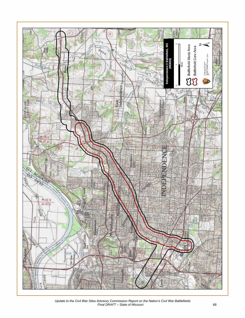
Independence II (MO025) Location Jackson County Campaign Price’s Missouri Expedition (1864) Battle Date(s) October 22, 1864 Principal Commanders Major General Alfred Pleasonton [US]; Brigadier General William L.
Cabell, Colonel William F. Slemons [CS] Forces Engaged Provisional Cavalry Division, Department of Missouri [US]; Cabell’s
Brigade and Slemon’s Brigade, Fagan’s Division, Army of Missouri [CS]
Results Confederate victory Study Area 6,449.78 acres The 1993 Study Area and Core Area did not accurately reflect the full
extent of the battle landscape. The ABPP expanded the Study Area to include all of the locations of fighting, and realigned the boundaries to follow the historic road network more closely. The ABPP added the Union approach route to Independence from the east and the route used by withdrawing Confederates to the southwest of town.
The ABPP expanded the Core Area significantly to include the initial point
of contact between Union and Confederate forces; the area of subsequent fighting through the town of Independence; the Confederate lines of battle in town; and areas of sustained engagement along the Confederate route of withdrawal the southwest. The portions of the Study Area and Core Area that represent this southwestern movement end at a mileage point described in action reports found in The War of the Rebellion: a Compilation of the Official Records of the Union and Confederate Armies.
Potential National 0.00 acres Register Lands Protected Lands 0.00 acres
Publicly Accessible Lands 0.00
Management Area(s) None Friends Group(s) None Preservation Activities Advocacy Since 1993 Cultural Resource Surveys and Inventories Fundraising Interpretation Projects Land or Development Rights Purchased Legislation Planning Projects Research and Documentation
Other
Public Interpretation Brochure(s) Since 1993 Driving Tour
Living History Maintained Historic Features/Areas Visitor Center Walking Tour/Trails

Update to the Civil War Sites Advisory Commission Report on the Nation’s Civil War Battlefields Final DRAFT – State of Missouri 67
Wayside Exhibits/Signs Website
Other Condition Statement The landscape and terrain of this battlefield have been altered beyond
recognition since the period of significance. The City of Independence has overwhelmed the battlefield and it is now an urban landscape. Commemorative and interpretive opportunities exist.
Historical Designation None
Update to the Civil War Sites Advisory Commission Report on the Nation’s Civil War Battlefields Final DRAFT – State of Missouri 68

Update to the Civil War Sites Advisory Commission Report on the Nation’s Civil War Battlefields Final DRAFT – State of Missouri 69
Kirksville (MO013) Location Adair and Macon Counties Campaign Operations North of Boston Mountains (1862) Battle Date(s) August 6-9, 1862 Principal Commanders Colonel John McNeil, Lieutenant Colonel Alexander M. Woolfolk, and
Colonel James McFerran [US]; Lieutenant Colonel Joseph C. Porter [CS]
Forces Engaged Kirksville: Detachments of the 1
st, 2
nd, 9
th, and 11
th Missouri State
Militia Cavalry, Rice's Independent Company, 3rd
Iowa Cavalry and a section of the 3
rd Indiana Light Artillery. Painter's Creek:
Detachments of the 1st and 6
th Missouri State Militia Cavalry, the 7
th
Missouri Cavalry, and the 33rd
Enrolled Missouri Militia Infantry. Walnut Creek and Seesford: Detachments of the 1
st, 5
th, and 6
th
Missouri State Militia Cavalry, the 7th Missouri Cavalry, and the 33
rd
Enrolled Missouri Militia Infantry [US]; 1st and 2
nd Northeast Missouri
Cavalry; Confederate Irregulars [CS] Results Union victory Study Area 10,708.07 acres
The ABPP revised the 1993 Study Area to include the retreat route of Confederate forces from Kirksville down towards New Cambria to incorporate fighting that took place on August 8 and 9. The Federal approaches to New Cambria along the railroad were also added. These troops stumbled into Porter’s scouts east of New Cambria and initiated the two-day running engagement back up the Chariton River.
The Core Areas were revised to represent the initial expulsion of Porter’s
Confederates from Kirksville by a smaller but better trained and well-equipped Federal force on August 6, the rearguard ambush at Painter's Creek on August 8, a second rearguard action at Walnut Creek in the early morning hours of August 9, and the final skirmish which took place later that day at Seesford as Confederate forces retreated across the Chariton River.
Potential National 8,754.17 acres Register Lands Protected Lands 609.86 acres Missouri Department of Natural Resources, 516.49 acres, fee simple
Missouri Department of Conservation, 93.37 acres, fee simple
Publicly Accessible Lands 609.86 acres
Missouri Department of Natural Resources, Thousand Hills State Park, 516.49 acres Missouri Department of Conservation, Griffith Memorial Conservation Area, 60.89 acres Missouri Department of Conservation, Big Creek Conservation Area, 32.48 acres
Update to the Civil War Sites Advisory Commission Report on the Nation’s Civil War Battlefields Final DRAFT – State of Missouri 70
Management Area(s) Big Creek Conservation Area Griffith Memorial Conservation Area Thousand Hills State Park Friends Group(s) None Preservation Activities Advocacy Since 1993 Cultural Resource Surveys and Inventories Fundraising Interpretation Projects Land or Development Rights Purchased Legislation Planning Projects Research and Documentation
Other
Public Interpretation Brochure(s) Since 1993 Driving Tour
Living History Maintained Historic Features/Areas Visitor Center Walking Tour/Trails Wayside Exhibits/Signs Website
Other Condition Statement Much of the landscape has been altered and fragmented, leaving
some essential features. The main engagement area at Kirksville has been overwhelmed by the growth of the town; however, the remaining battlefield is a good candidate for selective landscape protection. The historic road network and secondary Core Areas at Painter’s Creek, Walnut Creek, and Seesford have integrity and there are no specific threats to the remaining battlefield landscape. Kirksville presents an opportunity for battlefield preservation and interpretation over the long term.
Historical Designation None

Update to the Civil War Sites Advisory Commission Report on the Nation’s Civil War Battlefields Final DRAFT – State of Missouri 71