inception report support services for land use planning ... · sungai) bpkh forest area ......
TRANSCRIPT
Inception Report
Support Services for Land Use Planning, District Readiness,
Strategic Environmental Assessment, and Related
Preparatory Activities in Indonesia for the Green Prosperity Project in
Indonesia
Contract # GS10F0086K
Final Draft following MCC Review and Comment
13 January 2013
Prepared for: Millennium Challenge
Corporation 875 15th St., NW
Washington, D.C. 20005
Submitted by: Abt Associates Inc.
4550 Montgomery Avenue Suite 800 North
Bethesda, MD 20814
In Partnership with: ICRAF, Indonesia
URDI, Indonesia
Th
Draft Inception Report Contract # GS10F0086K
Abt Associates Inc. Contents ▌pg. i
Draft Inception Report
Table of Contents
Abbreviations and Acronyms ............................................................................................................. iii
1. Introduction ................................................................................................................................... 1
1.1 MCC Compact and Green Prosperity Project ..................................................................... 1
1.2 District Readiness Assessment and Project Implementation Preparation ........................... 3
1.3 Coordination with other contractors ................................................................................... 4
1.4 Summary of existing materials and consultations .............................................................. 5
2. Strategic approach and methodology for implementation of contract requirements, including data management and sharing .................................................................................. 10
2.1 Project implementation ..................................................................................................... 10
2.2 Project management and data management ...................................................................... 11
2.3 Knowledge management and sharing ............................................................................... 12
2.4 Utilization of subcontractors ............................................................................................. 12
3. Task description and implementation ....................................................................................... 13
3.1 District Readiness Assessment ......................................................................................... 13
3.1.1 Methodology ........................................................................................................ 14
3.1.2 Deliverables ......................................................................................................... 15
3.2 Land Use and Spatial Planning Needs Assessment in Starter Districts ............................ 15
3.2.1 Methodology ........................................................................................................ 16
3.2.2 Deliverables ......................................................................................................... 19
3.3 District Guidelines for Village Boundary Setting ............................................................. 19
3.3.1 Methodology ........................................................................................................ 22
3.3.2 Deliverables ......................................................................................................... 24
3.4 Multi-Stakeholder Forums ................................................................................................ 24
3.4.1 Methodology ........................................................................................................ 25
3.4.2 Deliverables ......................................................................................................... 29
3.4.3 Challenges and Issues .......................................................................................... 30
Draft Inception Report Contract # GS10F0086K
Abt Associates Inc. Contents ▌pg. ii
3.5 Strategic Environmental Assessment ................................................................................ 30
3.5.1 Methodology ........................................................................................................ 32
3.5.2 Deliverables ......................................................................................................... 33
3.6 Gender Findings ................................................................................................................ 33
4. Integrated Work Plan ................................................................................................................. 34
5. Project Organization ................................................................................................................... 35
6. Communications .......................................................................................................................... 36
7. Reporting ...................................................................................................................................... 37
8. Challenges .................................................................................................................................... 38
Annexes ................................................................................................................................................ 40
Draft Inception Report Contract # GS10F0086K
Abt Associates Inc. iii
Abbreviations and Acronyms
Abt Abt Associates, Inc. AMAN Indigenous Peoples Alliance of the Archipelago (Aliansi Masyarakat
Adat Nusantara) Apkarindo Indonesian Association of Rubber Farmers (Asosiasi Petani Karet
Indonesia) Apkasindo Indonesian Association of Oil Palm Farmers (Asosiasi Petani Kelapa
Sawit Indonesia) APKI Indonesian Association of Coconut Farmers (Asosiasi Petani Kelapa
Indonesia) API Indonesian Mining Association (Asosiasi Pertambangan Indonesia) ASSPUK Association for Assistance to Women in Small Business (Asosiasi
Pendamping Perempuan Usaha Kecil) Bappeda Local Development Planning Agency (Badan Perencana
Pembangunan Daerah) Bappenas National Development Planning Agency (Badan Perencana
Pembangunan Nasional) BIG Geospatial Information Agency (Badan Informasi Geospasial,
formerly Bakosurtanal) BKPRN National Coordinating Agency for Spatial Use Management (Badan
Koordinasi Penataan Ruang Nasional) BKSDA Natural Resources Conservation Center (Balai Konservasi Sumber
Daya Alam) BP-DAS Watershed Management Agency (Balai Pengelolaan Daerah Aliran
Sungai) BPKH Forest Area Strengthening Center ((Balai Pemantapan Kawasan
Hutan) BPPHP Agency for Monitoring the Use of Production Forest (Balai
Pemantauan Pemanfaatan Hutan Produksi) CAPPA Community Alliance for Pulp and Paper Advocacy (now known as
CAPPA – Keadilan Ekologi) CRM Client Relationship Management CSO Civil Society Organization DANIDA Danish International Development Agency DAS Watershed (Daerah Aliran Sungai) DPRD Local Parliament (Dewan Perwakilan Rakyat Daerah) DRA District Readiness Assessment ESMS Environment and Social Management System FGD Focus Group Discussion FPIC Free Prior Informed Consent
Draft Inception Report Contract # GS10F0086K
Abt Associates Inc. iv
FSC Forest Stewardship Council Gaperindo Indonesian Federation of Estate Crop Entrepeneurs (Gabungan
Pengusaha Perkebunan Indonesia) GAPKI Indonesian Federation of Palm Oil Entrepreneurs (Gabungan
Perusahaan Kelapa Sawit Indonesia) Gapkindo Indonesian Federation of Rubber Entrepreneurs (Gabungan
Perusahaan Karet Indonesia) Gapperindo Indonesian Federation of Associations of Estate Crop Farmers
(Gabungan Asosiasi Petani Perkebunan Indonesia) GIS Geographical Information System GOI Government of Indonesia GOW Coalition of Women’s Organizations (Gabungan Organisasi Wanita) GP Green Prosperity program GPS Global Positioning System HCV High Conservation Value ICRAF International Centre for Research in Agroforestry IFC International Finance Corporation IWAPI Indonesian Association of Women Entrepreneurs (Ikatan Wanita
Pengusaha Indonesia) JKPK-H (Jaringan Kerja Penanggulangan Kejahatan Kehutanan) JKPP Participatory Mapping Network (Jaringan Kerja Pemetaan
Partisipatif) KADIN Indonesian Chambers of Commerce and Industry (Kamar Dagang dan
Industri) KKI-WARSI Indonesian Conservation Community (Komunitas Konservasi
Indonesia Warung Informasi Konservasi) KOWANI National Council of Women’s Organizations in Indonesia (Kongres
Wanita Indonesia) KPPOD Regional Autonomy Watch (Komite Pemantauaan Pelaksanaan
Otonomi Daerah) L-CDS Low-Carbon Development Strategy LEG Local Economic Governance LUWES Land Use Planning for Low Emission Development Strategy M&E Monitoring and Evaluation MCA-I Millennium Challenge Account-Indonesia MCC Millennium Challenge Corporation MCI Millennium Challenge Indonesia MDG Millennium Development Goals METI Indonesian Renewable Energy Society (Masyarakat Energi
Terbarukan Indonesia)

Draft Inception Report Contract # GS10F0086K
Abt Associates Inc. v
MoE State Minister of Environment MoF Minister of Forestry MoHA Minister of Home Affairs MoPW Minister of Public Works MOU Memorandum of Understanding MP3EI Master Plan for Acceleration and Expansion of Indonesian Economic
Development (Masterplan Percepatan dan Perluasan Pembangunan Ekonomi Indonesia)
MSF Multi-Stakeholder Forum Musrenbang Development Planning Meeting (a local participatory budgeting and
consultation process that replaced Indonesia’s formerly centralized and top-down government system) (Musyawarah Perencanaan Pembangunan)
Musrenbangda Regional Development Planning Meeting (Musyawarah Perencanaan Pembangunan Daerah)
NGO Non-Government Organization NREL National Renewable Energy Laboratory NRM Natural Resources Management PDRB District Gross Domestic Product Perda Local Regulation (Peraturan Daerah) Permendagri Minister of Home Affairs Regulation PermenHut Minister of Forestry Regulation PermenLH State Minister of Environment Regulation PermenPU Minister of Public Works Regulation PES Payment for Ecosystem Services PHBM Community Based Forest Management (Pengelolaan Hutan Berbasis
Masyarakat) PLN State-owned Electricity Company (PT Perusahaan Listrik Negara) PLUP Participatory Land Use Planning PNPM National Program for Community Empowerment (Program Nasional
Pemberdayaan Masyarakat) Pokja Working Group (Kelompok kerja) PP Government Regulation (Peraturan Pemerintah) PRISAI Indonesian Safeguard Principles, Criteria, Indicators (Prinsip, Kriteria,
Indikator Safeguards Indonesia) (safeguards framework developed by REDD+ Taskforce)
PTPN State-owned Estate Crops Company (PT. Perkebunan Nusantara) RAD-GRK Local Action Plan for Reducing Greenhouse Gas Emissions (Rencana
Aksi Daerah untuk Pengurangan Emisi Gas Rumah Kaca)
Draft Inception Report Contract # GS10F0086K
Abt Associates Inc. vi
RAN-GRK National Action Plan for Reducing Greenhouse Gas Emissions (Rencana Aksi Nasional untuk Pengurangan Emisi Gas Rumah Kaca)
RATA Rapid Agrarian Tenure Assessment RE Renewable Energy REDD+ Reducing Emissions from Deforestation and Forest Degradation RFQ Request for Quotations RTRWK District Spatial Plan (Rencana Tata Ruang Wilayah Kabupaten) RTRWP Provincial Spatial Plan (Rencana Tata Ruang Wilayah Provinsi) Satgas Task Force (Satuan Tugas) SEA Strategic Environmental Assessment SGA Social and Gender Assessment (MCC) SIKOK Indonesian Population Information and Consultation Foundation
(Sentra Informasi dan Konsultasi Orang Kito) SOW Scope of Work SPKS Oil Palm Farmers Union (Serikat Petani Kelapa Sawit) TKPSDA Coordination Team for Water Resource Management (Tim Koordinasi
Pengelolaan Sumber Daya Air) TOR Terms of Reference TTL Task Team Leader UKP4 Presidential Working Unit on Development Supervision and Control
(Unit Kerja Presiden Bidang Pengawasan dan Pengendalian Pembangunan)
URDI Urban And Regional Development Institute USAID United States Agency for International Development USDE United States Department of Energy USFS United States Forestry Service WALHI Indonesian Forum for the Environment (Wahana Lingkungan Hidup
Indonesia) ZSL Zoological Society of London
Draft Inception Report Contract # GS10F0086K
Abt Associates Inc. 1
1. Introduction
Indonesia has experienced a strong level of economic development over the last 10 years with average real economic growth varying from 3 to over 6 percent per year. Over the last 5 years this measure has been relatively steady at 6 percent, while western countries were experiencing varying degrees of recession over the same time frame. These growth levels should translate to improved livelihoods for the people of Indonesia. Yet despite this rate of economic growth, poverty remains a major socio-economic issue for a large number of people in Indonesia, a large proportion of whom live and work in rural areas. In addition, households headed by women and certain other groups are highly vulnerable to poverty.
The challenge is to determine ways to lift the rural poor out of poverty by improving the conditions for economic growth in ways that can sustain natural resources for future generations and maintain the livelihoods of the large rural population. This challenge has been taken up by several donors – including the Millennium Challenge Corporation (MCC) – which will provide capital for investments for energy generation from renewable resources, developing more appropriate agricultural production systems and methods, and exploring economic development alternatives with the objective of protecting Indonesia’s resource base and reducing overall poverty in rural areas. Concomitant to this objective is to join the rest of the world in finding ways to reduce the levels of greenhouse gas emissions. The Government of Indonesia (GOI) has committed to unilaterally reduce its greenhouse gas (GHG) emissions by 26% (or 41% with international assistance) by 2020, while maintaining economic growth of at least 7% by 2014 (the “26-41/7 policy”).1
1.1 MCC Compact and Green Prosperity Project
MCC Compact
The MCC’s five-year, $600 million compact with Indonesia (Indonesia Compact) is designed to reduce poverty by promoting economic growth through three projects: the Green Prosperity Project; the Community-Based Nutrition to Prevent Stunting Project; and the Procurement Modernization Project.
The majority of Indonesia’s poor live in rural areas that are rich in natural resources. However, illegal logging, land conversion for agriculture and mining, and other unsustainable land use practices threaten the country’s ability to sustain economic growth and reduce poverty. Lack of clarity concerning land and natural resource use licensing and the jurisdictional boundaries of villages deters investment and impedes the GOI’s ability to effectively manage critical natural resources.
1 “We are devising an energy mix policy including land use, land use change, and forestry that will reduce our emissions by 26 percent by 2020 from Business As Usual. With international support, we are confident that we can reduce emissions by as much as 41 percent.” Extract from President Yudhoyono’s speech to the G20 Leaders’ Summit in Pittsburgh on September 25, 2009.
Draft Inception Report Contract # GS10F0086K
Abt Associates Inc. 2
The Green Prosperity Project seeks to address these critical constraints to economic growth while supporting the GOI’s commitment to a more sustainable, less carbon-intensive future.2
Green Prosperity Project
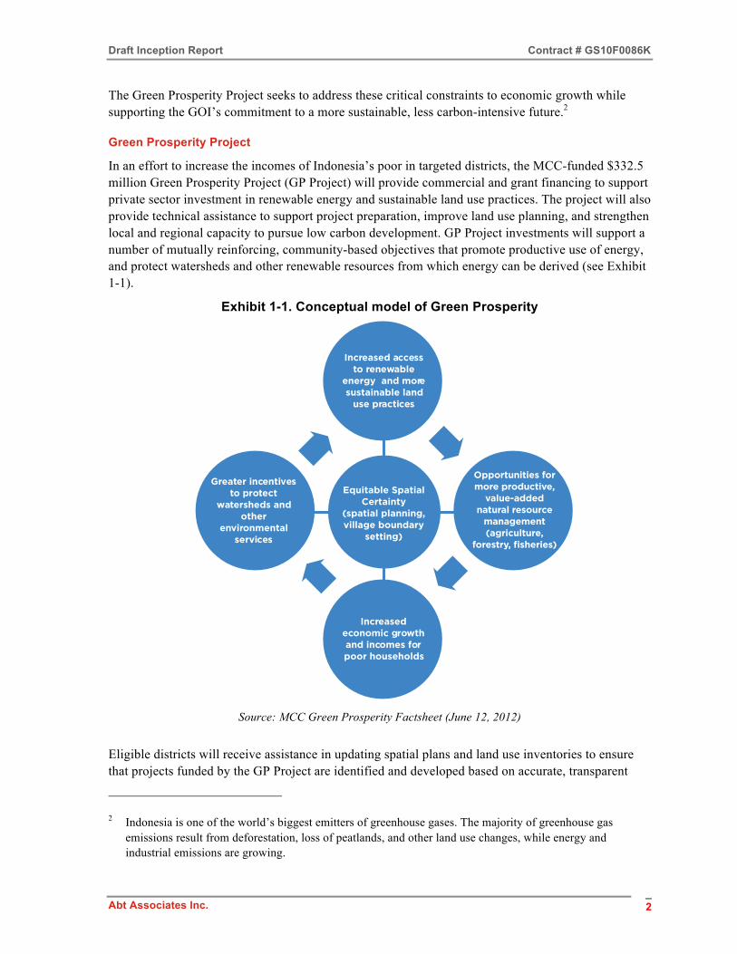
In an effort to increase the incomes of Indonesia’s poor in targeted districts, the MCC-funded $332.5 million Green Prosperity Project (GP Project) will provide commercial and grant financing to support private sector investment in renewable energy and sustainable land use practices. The project will also provide technical assistance to support project preparation, improve land use planning, and strengthen local and regional capacity to pursue low carbon development. GP Project investments will support a number of mutually reinforcing, community-based objectives that promote productive use of energy, and protect watersheds and other renewable resources from which energy can be derived (see Exhibit 1-1).
Exhibit 1-1. Conceptual model of Green Prosperity
2Green Prosperity!|!June 12, 2012
Green Prosperity Project investments will support a number of mutually-reinforcing, community-based objectives (see figure below) that promote productive use of energy, and protect watersheds and other renewable resources from which energy can be derived.
Eligible districts will receive assistance in updating spatial plans and land use inventories to ensure that projects funded by Green Prosperity are identified and developed based on accurate, transparent land use data and e!cient use of critical ecosystem services. Complementary investments in capacity building and knowledge management, or “green knowledge,” are intended to improve the project’s long-term e"ective-ness and sustainability.
Conceptual model
Increased accessto renewable
energy and moresustainable land
use practices
Equitable SpatialCertainty
(spatial planning,village boundary
setting)
Greater incentivesto protect
watersheds andother
environmentalservices
Increasedeconomic growthand incomes forpoor households
Source: MCC Green Prosperity Factsheet (June 12, 2012)
Eligible districts will receive assistance in updating spatial plans and land use inventories to ensure that projects funded by the GP Project are identified and developed based on accurate, transparent
2 Indonesia is one of the world’s biggest emitters of greenhouse gases. The majority of greenhouse gas
emissions result from deforestation, loss of peatlands, and other land use changes, while energy and industrial emissions are growing.

Draft Inception Report Contract # GS10F0086K
Abt Associates Inc. 3
land use data and efficient use of critical ecosystem services. Complementary investments in capacity building and knowledge management (“green knowledge”) are intended to improve the project’s long-term effectiveness and sustainability. Key stakeholders and potential sponsors include local governments and institutions; private enterprises in the renewable energy, agriculture, forestry, and water sectors; financial institutions; smallholder farmers; and local and international NGOs.
The GP Project has four core activities: an investment facility, participatory land-use planning, technical assistance and oversight, and green knowledge capacity building. The Abt Associates implemented Project detailed here will focus on the latter three areas in an integrated fashion, coordinating with other 609 (g) contractors and helping to the lay the groundwork for the Investment Facility described below.
GP Investment Facility
The GP investment facility (GP Facility) will provide commercial and grant financing to support economic development projects in two areas:
• Renewable energy, including small operations (less than 10 megawatts), hydropower, bio-waste (agricultural waste) to energy, biogas, and solar.
• Sustainable land use and natural resource management, including sustainable agriculture, forestry, fisheries, and watershed management.
All GP-funded projects must meet the investment criteria of the Indonesia Compact, increase the income of Indonesians in targeted areas, and achieve an economic rate of return of at least 10 percent.
They must also implement appropriate environmental and social safeguards that conform to MCC’s Environmental Guidelines and Gender Policy, Indonesian regulations and standards, and international best practice.
Through Millennium Challenge Account-Indonesia (MCA-I), being the entity responsible for administering the compact, the GOI will hire an independent facility manager to oversee the GP Facility and monitor the performance of all loans and grants. An investment committee will review and approve funding applications through a competitive and transparent process.
GP Project Locations and Starter Districts
The GP Project will concentrate in provinces and districts with high potential for achieving poverty alleviation and environmental objectives. Candidate provinces include Riau, Jambi, West Sumatra, South Sumatra, Bengkulu, West Sulawesi, South Sulawesi, Southeast Sulawesi, West Kalimantan, East Kalimantan, West Nusa Tenggara and East Nusa Tenggara. These provinces have been selected based on a range of social, economic, environmental, and institutional indicators, including poverty levels, renewable energy potential, economic growth potential, governance, significant forest cover, and peatlands under threat of degradation or destruction.
1.2 District Readiness Assessment and Project Implementation Preparation
MCC and the GOI have agreed to initiate the GP Project in four districts in the provinces of Jambi and West Sulawesi (the “starter districts”). Consistent with a river basin management approach, the starter districts include an upland and lowland district in each, as indicated in the following table.

Draft Inception Report Contract # GS10F0086K
Abt Associates Inc. 4
Starter Provinces and Districts Province Upland District Lowland District Jambi Merangin Muaro Jambi
West Sulawesi Mamasa Mamuju
Inclusion of other provinces and districts in the GP Project is subject to mutual agreement between MCC and the GOI based on the results of a District Readiness Assessment (DRA). To be selected, districts must have government-approved spatial plans in place. They must also agree to make land-use information and licensing processes transparent and accessible to MCC, relevant government planning and service agencies, and the general public.
This District Readiness Assessment and Project Implementation Preparation Inception Report has eight parts. The remainder of this Section looks at coordination with other contractors, summarizes existing materials and consultations with stakeholders, and reviews the challenges faced. Section 2 sets out the strategic approach and methodology for project implementation. Section 3 describes each task and how it will be implemented. Section 4 shows how these tasks will be integrated over the timeframe of the DRA. Staffing for DRA is presented in Section 5. The approach to communication is given in Section 6. Section 7 discusses the reporting plan. Finally, in Section 8 we describe the challenges faced by DRA in carrying out the work plan. Additional supporting material has been included in the Annexes.
1.3 Coordination with other contractors
Coordination, and in some cases data sharing and joint implementation, among different contractors supporting the GP Project is important to ensure successful project development and implementation. To facilitate coordination and information exchange between GP contractors, MCC and the GOI will convene periodic meetings of contractors in Jakarta and/or by teleconference. These meetings will generally cover the following topics:
• a status report of work under each contract, with particular focus on key points of coordination/consultation with other contractors;
• substantive presentations by contractors on topics of concern or interest to other contractors; and
• an opportunity to share relevant data and findings among contractors.
In addition to this coordination, the Abt team will take additional steps to work collaboratively with key 609(g) and other contractors/consultants. This includes collaboration on the MSFs (where NREL will play a role), linkages between the SEA work and the ESMS system, gender analysis, and communications.
In the area of Strategic Environmental Assessments for example, given that these can serve as a screening instrument to provide preliminary identification of likely risks and pressures to key elements of future GP investment in specific proposed parts of the four starter districts, this data can/will be linked to NREL’s feasibility studies. Abt will also work with its local partners URDI and ICRAF to assist the Provincial GP Task Force mandated in the MoU, in evaluating existing and planned SEA, spatial planning, and Musrenbangda by both Jambi and West Sulawesi provincial governments. This will help strengthen baseline data on social, economic and biophysical conditions

Draft Inception Report Contract # GS10F0086K
Abt Associates Inc. 5
of the questioned regions. The baseline will significantly contribute to the development of Green Knowledge (Task 8), the finalization of District Readiness Criteria (Task 2), and the ESMS consultant. Selected key partners include:
National Renewable Energy Laboratory (NREL)/United States Department of Energy (USDE): Through an interagency agreement with the USDE, MCC is utilizing renewable energy specialists from NREL together with other agriculture and natural resource management experts to support initial assessment and development of potential renewable energy and sustainable land use investments in GP candidate provinces. The NREL team, which includes several engineers, environmental specialists, and an economist, has been working on the GP Project since 2011.
Impact Evaluation and Baseline Data Collection: MCC is in the process of procuring an impact evaluation firm to work with MCC and the GOI to develop an impact evaluation strategy and collect baseline data in potential GP project areas. This work is intended to inform activity design and establish a baseline of key outcomes for the project. It will also be used to inform ex-ante economic rate of return projections and be utilized for impact evaluation (such as propensity score matching) purposes.
In addition to the above, MCC employs various individual consultants and personal service contractors that may support different elements of the GP Project from time to time, including support for environmental and social assessment, gender integration, and project finance. MCC will coordinate access to these consultants on an as-needed basis.
1.4 Summary of existing materials and consultations
In order to thoroughly understand the current context for implementation of the DRA Activity, several meetings have been held by Abt, both at the national level and at the provincial level (in Jambi and West Sulawesi). These introductory and consultation meetings have been held with key government agencies at both provincial and district levels3, as well as with NGOs and international donors active in GP-related work. The purpose was to raise awareness of the team and its plans, as and begin analyzing the operating environment in which DRA’s complex suite of integrated activities will be implemented over the next year. Annex 1 contains a summary of these meetings.
During the course of these meetings and through independent due diligence, the DRA Team further identified and collected additional documents relating to the two provinces, the four districts and nationwide. These documents, which will help in planning and implementation, are listed in Annex 2. In addition, the team has compiled a preliminary list of NGOs operating in the two starter provinces and four districts.4 This list incorporates data from a very useful database of NGOs in Indonesia developed and maintained by SMERU Research Institute, data on NGOs registered at the Kesatuan Bangsa (National Unity) District Office, and the experience of the DRA’s Task Team Leaders (TTLs) and related experts. Annex 3 contains the SMERU list of NGOs in Jambi and West Sulawesi
3 Minutes of meetings and attendance lists are available on request. 4 The list of women’s NGOs has been shared with the DRA Team.
Draft Inception Report Contract # GS10F0086K
Abt Associates Inc. 6
provinces. The SMERU database and the UK Charity's Portal Indonesia NGO (PiNgo)5 can later also be used as a starting point to identify NGOs in districts in the other 10 provinces.6
Some key findings of these meetings and preliminary research follow.
Understanding of GP Program
The local governments conveyed that there was a general lack of understanding and some confusion among district agencies regarding the GP Project in terms of both the process and concrete steps, and what they were expected to do. To help clarify the purpose of the GP Project and the role of the district government, in each starter district a Memorandum of Understanding (MOU) on the preparation and implementation of the GP Project was drawn up and entered into between representatives of the district government, the provincial government and MCA-I. These MOUs cover the following topics:
• objectives and expected benefits of GP Project
• scope of GP Project
• GP funding facility (GP Facility)
• four requirements that a district must satisfy in order to become a GP Project location
• type of support expected from each party to the MOU
• MCC Compact Grant Agreement schedule
• supporting regulations for GP Project activities
• scope of work of DRA activity
The MOUs between MCA-I and the four starter districts of Muaro Jambi and Merangin in Jambi province, and Mamuju and Mamasa districts in West Sulawesi province, were all signed at a ceremony held in Jakarta on November 8, 2012.
The DRA team’s province/district-focused approach should help to provide clarity by engaging key local stakeholders in an extensive and carefully coordinated dialog, and the DRA team will also work with NREL, the MCC team, and the MCA-I team on this issue.
Provincial/District Coordination Team and Working Group
A Provincial Coordination Team (Tim Koordinasi) and a Working Group (Pokja) have been established to support preparations for implementing the Compact Program under decrees issued by the Governors of Jambi and West Sulawesi Provinces in November 2012.7 Similar decrees establishing the Coordination Teams and Working Groups for the starter districts in Jambi and West Sulawesi have not yet been issued by the districts concerned.
5 http://www.indonesiango.org/en/ 6 The full list of NGOs in the SMERU database can be accessed at www.smeru.or.id/ngolist.php. 7 West Sulawesi Governor Decree No. 461 of 2012 dated November 2, 2012, and Jambi Governor Decree No.
37/Kep. gub/Bappeda/2012 on Support Team for MCC Compact in Jambi Province

Draft Inception Report Contract # GS10F0086K
Abt Associates Inc. 7
Existing Multi-Stakeholder Forums
Rapid rollout of the DRA activities will be facilitated by drawing on existing local experience; in particular tapping into any GP related working groups, forums or other entities that already exist. Starting with Jambi, where there is a broader institutional history of working on GP issues, the team will work to avoid “reinventing the wheel” and while our initial assessment is that this institutional capacity for specific thematic issues is relatively nascent, groups such as the Watershed Forum (forestry office), the Provincial Water Resource Council and the Coordination Team for Water Resource Management (per River Basin) (both from the public works office) will provide a platform for the MSF and other activities.
It is understood that he GP Project is not primarily concerned with supporting the forum for management of the entire river basin, The emphasis of GP is on inter-village sub-watershed landscapes (sub-DAS), which are more likely to correspond with administrative areas such as sub-districts (Kecamatan).8
To date, multi-stakeholder forums have generally been established on an ad hoc or project basis, usually by a provincial or district agency. They all appear to lack any existing mechanisms for adequate representation of women and vulnerable groups. The existing forums are listed below (see Exhibit 1-2 for further details):
• In Jambi, a Provincial Water Resource Council was established in December 2011 through a decree of the Jambi Governor, with non-government representation of 50%. A Watershed Forum for the Batanghari Watershed was established back in January 2009, also by a decree of the Jambi Governor, and also with considerable non-government representation.
• In Merangin and Muaro Jambi Districts in Jambi, the local government has not yet facilitated or organized either a Watershed Forum or a Water Resource Council.
• In West Sulawesi, a Provincial Water Resource Council was established by a governor’s decree in June 2010, with government agencies, community organizations and NGOs all represented. In June 2012, a Provincial Watershed Information and Communication Forum were established by a Governor’s decree, and this forum is mainly made up of representatives of government agencies.
• In Mamasa District, the existing District Watershed Forum is not being coordinated by the local government, in this case the forestry agency. Only civil society organizations (CSOs) are represented. While Mamuju District does not yet have a Watershed Forum or a Water Resource Council, the district agencies are members of the Provincial Watershed Forum.
In addition, it is worth noting that under Ministerial Regulation No. 39 of 2009 (on Guidelines for Preparation of Integrated DAS Management) a long-term integrated watershed management plan has to be prepared for each watershed. In August 2012, a provincial team was established to prepare this plan for the Budong-Budong/Lariang Mamasa Watershed, bringing together representatives from the provincial agencies and the Mamuju District agencies. Members of these councils, teams, forums, and the Integrated Watershed Management Plans (if prepared) for the local watersheds will be screened to identify potential stakeholder organizations that can participate in the MSF activity.
8 See Bennett’s SSA-03 and Appendix

Draft Inception Report Contract # GS10F0086K
Abt Associates Inc. 8
Exhibit 1-2. Institutional forums
Based on the field findings, both the provincial and district governments see the value of a communication forum (or MSF) as a means to collate the community’s needs and aspirations. To date, the community consultations facilitated by local governments (both provinces and districts) use a mechanism called Musrenbang (Musyawarah Perencanaan Pembangunan), which is a local development consultation process. The Musrenbang consultation process starts at the village level and ends at the district level. The annual meetings at the village level involve formal and informal local leaders along with local organizations and groups, who deliberate and aim to reach agreement on the proposed activities for the upcoming financial year.
Community Based Forest Management (Pengelolaan Hutan Berbasis Masyarakat, PHBM) Policy
In Jambi Province, the Center for Monitoring the Use of Production Forest (Balai Pemantauan Pemanfaatan Hutan Produksi, or BPPHP) – a vertical organization of the Forestry Ministry – has a community empowerment program that involves granting access to utilize degraded production forest and convert it into People’s Plantation Forest (Hutan Tanaman Rakyat). As with other local forms,
Water Resources Management:
• Provincial Water Resource Council, established by a Governor’s Decree and financed by the Provincial Budget through the Provincial Public Works Agency.
• Coordination Team for Water Resource Management (per River Basin), either established by a Decree of the Minister of Public Works and financed by the national budget where the area crosses provincial boundaries (e.g. Batanghari Basin in Jambi and West Sumatra, and Saddang Basin in West Sulawesi and South Sulawesi), or established by a Decree of the Governor and financed by the provincial budget where the area crosses district boundaries.
Each forum has considerable representation by non-government stakeholders, with around 50% of the members of the Water Resource Council being elected.
Forestry:
• Watershed Forums (established per watershed per province) initiated by the Ministry of Forestry, which are established (a) by a Governor’s Decree where the area crosses district boundaries, or (b) by the District Head if the area is all located within one district, and are financed from the state budget through the Watershed Management Center (BP-DAS). Stakeholders from upland to downstream – including government agencies, the private sector and civil society/local communities – should all be represented in the Watershed Forum.
“Remembering that the problems of watershed management are of a multi-sectoral, boundary-crossing and multi-disciplinary nature, management of the watersheds should be done holistically and integrated, so there is a clear need for the Watershed Forum to connect stakeholders with interests in various aspects of watershed management. So far, the watershed forums that have been established are not generally performing this role and are not functioning properly, while related parties are not yet actively participating in integrated watershed management.”
(Source: National Meeting of Watershed Forums and Experts, Jakarta, 19-20 October 2010; see www.dephut.go.id/files/pertemuan_forumDAS2010.pdf)
Under the Integrated Watershed Management Plan prepared for each watershed, a stakeholder analysis needs to be conducted before the issues are analyzed.

Draft Inception Report Contract # GS10F0086K
Abt Associates Inc. 9
there does not appear to be adequate involvement of women and other vulnerable groups. The program is based on Minister of Forestry Regulation No. P55 of 2011 on Converting Production Forest into People’s Plantation Forest. In Jambi Province, BPPHP has reserved 49,703 hectares of production forest for conversion into Hutan Tanaman Rakyat, in five districts: Kerinci, Merangin, Tebo, Sarolangun, and Muaro Jambi. In Merangin and Muaro Jambi, BPPHP has reserved 1,370 and 668 hectares, respectively.
This forestry community empowerment program involves BPPHP providing field trainers and coaches to assist communities in areas such as group and organizational development, legal affairs, and livelihood projects. BPPHP reviews proposals submitted by the local community or a specific entity. The district government will then grant a license provided the proposal passes BPPHP’s panel review.
Land Use and Spatial Planning
Land dispute issues were noted in all starter districts that the DRA Team visited during preliminary consultations for this Inception Report. However, conflicts involving the local community, private sector and government occur more frequently in Jambi than in West Sulawesi. The issues arising relate to occupation of privately owned land and state land (protection forest, conservation forest).
The Provincial Spatial Plans (RTRWP) for Jambi and West Sulawesi and the District Spatial Plans (RTRWK) for each of the four starter districts have obtained substantive approval from the National Coordinating Agency for Spatial Use Management (Badan Koordinasi Penataan Ruang Nasional, or BKPRN). The reviews by the provincial legislatures (DPRD Provinsi) on the RTRWP of Jambi and West Sulawesi are now underway. Neither the two provinces nor the four starter districts have a local regulatory basis (Perda, or local regulation) for their spatial plans.
In both West Sulawesi and Jambi Provinces, land mapping has been conducted and recorded administratively. However, field checking to compare what has been determined and established administratively has generally not yet been conducted. The local governments consider that improving the skills of district and provincial staff in using GIS for land administration important.
In West Sulawesi, ‘clean and clear’ boundary setting is not yet comprehensively in place. This is due to the ongoing establishment of new districts, sub-districts and villages (known as pemekaran in Indonesian), one example being the district boundaries between Polman and Mamasa.
Strategic Environmental Assessment (SEA)
Jambi has completed its SEA on the provincial development planning process (Musrenbangda) and provincial spatial plan (RTRWP), led by the Provincial Development Planning Board (Bappeda) and with broad collaboration from stakeholders. The SEA in West Sulawesi is currently being implemented by the Provincial Bappeda and will take a similar approach to stakeholder engagement in order to obtain feedback on the SEA draft. Both provinces have used the Ministry of Home Affairs (Permendagri) guidelines on SEA implementation.
While the Permendagri guidelines on SEA implementation provide clearer direction in terms of environmental planning, they do not contemplate gender issues as one of the social pressures. This critical need will be accommodated by the Abt team in developing the SEA methodology. Since Merangin District in Jambi is now planning its SEA, with the district government having already allocated a budget for the next fiscal year, this presents a strategic entry point for the Abt team to propose a methodology that incorporates gender issues as a defined social pressure, and therefore
Draft Inception Report Contract # GS10F0086K
Abt Associates Inc. 10
enriches the MoHA and MoE guidelines. In addition, the Abt team will closely coordinate its work on SEA issues with the ESMS activity already underway, facilitating sharing of information and leveraging of results between these two closely related GP initiatives.
2. Strategic approach and methodology for implementation of contract requirements, including data management and sharing
The GP Project, as a part of the MCC Compact with the GOI, seeks to promote sustained growth and poverty reduction in Indonesia through investments in renewable energy and the sustainable management and use of natural resources.
2.1 Project implementation
Project activities will include both technical and financial assistance for low-carbon development projects, and will be based on:
• the GOI’s medium- to long-term development plan
• the GOI’s medium- to long-term development plan (2012 Gender Equality and Women’s Empowerment – especially Book 2 Chapter 1 on Policy of Gender Mainstreaming)
• the GOI’s National Action Plan for Reducing Greenhouse Gas Emissions (Rencana Aksi Nasional untuk Pengurangan Emisi Gas Rumah Kaca, or RAN-GRK)
• Regional (Provincial and District) Spatial Plans (Rencana Tata Ruang Wilayah Provinsi, or RTRWP, and RTRW Kabupaten, or RTRWK)
• Intensive participatory land use planning involving local communities and governments in provinces and districts, which are selected based on their potential for poverty reduction and achieving environmental objectives. The land use planning will follow MCC Social and Gender Assessment (SGA) guidance on 30% women’s participation, with separate FGDs being held with women’s groups.
The tasks covered by this assignment are intended to (i) support the launch of the Green Prosperity Project in the starter districts, (ii) document lessons learned in order to inform the Project rollout in additional districts throughout the country, and (iii) develop and apply a rigorous methodology for selecting the additional districts. More specifically, in addition to developing inception and final reports, the following main tasks will be performed in project start-up activities in each starter district:
• District Readiness Assessment Criteria (Task 2)
• Land Use and Spatial Planning Needs Assessment (Task 3)
• Preparation of District Guidelines for Village Boundary Setting (Task 4)
• Facilitation of Multi-Stakeholder Forums (Task 5)
• Strategic Environmental Assessment (SEA) (Task 6)
Formulating the District Readiness Assessment Criteria based on the starter districts is the primary
Draft Inception Report Contract # GS10F0086K
Abt Associates Inc. 11
objective of the DRA, and is subject to MCC and MCA-I approval for rollout to additional candidate districts in the 12 provinces expected to participate in the GP Project. The other four tasks support this primary objective. Data management and sharing will be conducted by implementing a client/stakeholder management system (CRM using a shared database under Microsoft Outlook and Excel) and a document management tool such as EndNote.9
These five main tasks are interrelated, with outputs of some informing and serving as inputs for others. Furthermore, although the five tasks will be carried out separately in each of the four starter districts, the lessons learned in each district must be integrated to develop generic recommendations that can be applied in all other GP Project districts. Our approach to this assignment carefully integrates activities across both tasks and the four geographically dispersed pilot districts in order to effectively and efficiently achieve MCC’s objectives for this assignment.
In addition, a separate chapter will be prepared on gender, as a crosscutting activity for Tasks 2-6. The findings on gender will be summarized in a separate section of the final report.
An integrated work plan is being developed to ensure that (i) the Land Use and Spatial Planning Needs Assessment informs the District Readiness Assessment, the District Guidelines for Village Boundary Setting, and the SEAs; (ii) the Multi-Stakeholder Forums inform the District Guidelines for Village Boundary Setting and the SEAs; and (iii) the second round of Multi-Stakeholder Forums are in turn informed by the SEAs. In other words, the project tasks will be performed in a carefully orchestrated sequence to maximize interactions and shared learning. For more on the integration of these activities, please see Section 4 (Integrated Work Plan).
2.2 Project management and data management
The successful execution of these key tasks requires rigorous project management to overcome the geographical and logistical challenges of working in the four starter districts in Jambi and West Sulawesi. At the same time, there is a need to optimally utilize a combination of technical skills in the spheres of land use planning and natural resource management, and to facilitate productive interactions with a wide range of stakeholders, including MCC and MCA-I, senior government officials at the national, provincial, and district level, NGOs, and members of local communities. The integrated work plan is critical to ensuring that the project management has adequate capacity to coordinate activities in conditions of challenging geography, in order to ensure the necessary integration between the various tasks and their completion within the activity´s limited time frame.
As suggested in Abt’s response to the RFQ, three teams will be formed to focus, respectively, on the District Readiness Assessment and Multi-Stakeholder Engagement, on Land Use Planning and Boundary Setting, and on the SEA. Each team will be staffed by a Task Team Leader (TTL), appropriately qualified local and expatriate staff, and short-term consultants as required. Although some staff members will be based for the duration of the project in the two selected provinces, if not in each of the four districts, many of the technical staff will be required to move between the four starter district locations. The two provinces selected and the two starter districts in each province are far from Jakarta and, especially in the case of West Sulawesi, present challenges in terms of transportation, communications, and logistics. Field offices will be established in both Jambi and
9 The IT-based CRM and document management tools will considerably assist TTLs with their ongoing
operations and the preparation of the draft and final forms of the deliverables.

Draft Inception Report Contract # GS10F0086K
Abt Associates Inc. 12
West Sulawesi, with the former serving as the principle base of operations. A small virtual office in Jakarta will provide support to the field offices.
The Jambi office will serve as a coordinating hub for the deployment of the various teams. It will consolidate data collection and processing for wider application, provide access to and make use of the existing land use data and other GOI economic, social, and environmental databases, and manage ongoing working relationships with MCC, MCA-I, and other GOI departments and agencies. From the Jakarta office, Abt will manage administrative matters in coordination with the Jambi and Sulawesi teams, including final preparation and presentation of reports, translations, staffing and personnel, and financial management.
2.3 Knowledge management and sharing
In order to promote efficient and transparent knowledge management under the Project, the Abt team will establish a system of document sharing, filing, and uploading in close coordination with MCC. This will use a combination of tools, including maintenance of hard copies for review in Project offices, uploading of all relevant reports and files to the MCC SharePoint System for Indonesia, and potential use of a web site or other open source tool. The latter option can be evaluated as the new MCA comes formally online, as this institution would be an ideal repository for storing and sharing the knowledge generated by this activity. During the course of implementation, TTL Idris Sulaiman will also work with counterparts to analyze and evaluate tools for improving knowledge management for GP in the short and long term. He will offer practical recommendations and work with these institutions to both understand and apply them, emphasizing the use ICT to broaden the impact.
On points of relevant policy and institutional guidance, various national government agencies and relevant MCA-I and Millennium Challenge Indonesia (MCI) counterparts have welcomed engagement with the Abt team for the DRA. To ensure effective communication with relevant government institutions and organizations, a weekly DRA newsletter will be shared with the following institutions and organizations, with personal visits being made as needed:
• National Working Group for Geospatial Information (UKP4)
• Directorate General for Regional Development (BANGDA), Ministry of Home Affairs (MoHA)
• Directorate General for Empowerment of People and Villages (PMD), MoHA
• Directorate General for Spatial Planning, Ministry of Public Works
• Agency for Watershed Management (BPDAS), Ministry of Forestry (MoF)
• Directorate General for Land Rehabilitation and Social Forestry (RL&PS), MoF
• Ministry of Environment
2.4 Utilization of subcontractors
Abt is partnering with two key Indonesian sub-contractors – the International Centre for Research in Agroforestry (ICRAF, also known as the World Agroforestry Center) and the Urban and Regional Development Institute (URDI). Their roles and activities are discussed here, including the DRA tasks for which their resources can be leveraged. The participation of local institutions and experts across the program’s technical activities is critical for sustainability and long term success of the broader GP effort, as will be close coordination with the recently appointed CEO and GP Lead of the MCA-I.

Draft Inception Report Contract # GS10F0086K
Abt Associates Inc. 13
ICRAF
ICRAF will provide leadership on land-use planning and participatory boundary issues; access to Jambi infrastructure and experts; and assistance with the stakeholder forums. Considering ICRAF’s extensive experience in Jambi, the work in Jambi on Task 3 (Land Use and Spatial Planning) and Task 4 (Village Boundary Setting Guidelines) should provide an exemplar for the work in West Sulawesi. Together with the Participatory Land Use Planning Consultant from the GP team, ICRAF will nominate champions from the district governments of Merangin and Muaro Jambi to help implement Tasks 3 and 4 in West Sulawesi. This strategy is important for building a sense of ownership among local government counterparts.
To support integration between ICRAF’s work on Task 3 and other key DRA tasks, namely Task 2 (District Readiness Assessment), Task 5 (Multi-stakeholder Forum) and Task 6 (Strategic Environmental Assessment), the findings will need to be centralized and consolidated through regular coordination meetings chaired by the DRA’s COP. This will help ensure that the land use and spatial planning assessment can inform the district readiness criteria and be consistent with the SEA findings presented and discussed at the MSF.
URDI
URDI will contribute on regional and local planning issues, stakeholder relations, and coordination with key national and sub-national counterparts, and will provide access to additional technical expertise. Considering its core area of expertise, URDI will primarily work on Task 6 (SEA) and will also contribute to Task 3 (Land Use and Spatial Planning) by providing a spatial planning analysis for the target provinces/districts, analyzing key geographic, economic, and social issues for input into the deliverables. URDI’s Endrawati Fatimah, who has previously advised the Ministry of Public Works on analyzing economic policy options based on the collation of critical data on MDG goals, climate change and other areas, will contribute to the first three critical stages of the SEA – screening, scoping and assessment, and analysis. Since URDI’s institutional experience includes developing a monitoring and evaluation (M&E) system for Madura’s Suramadu inter-island connection based on its SEA recommendations, it will play a key role in incorporating the SEA findings and analysis into the project-specific ESMS requirements (Tier-2) for GP.
3. Task description and implementation
3.1 District Readiness Assessment
Policy documents such as Indonesia’s National Action Plan for Reducing Greenhouse Gases (RAN-GHG) provide a strong public commitment to reducing GHG emissions and a clear commitment to using technology to help solve this challenge.
The District Readiness Assessment (DRA) is a two-stage assessment of candidate districts in terms of their capacity and commitment, and investment opportunities to support environmentally sustainable, low-carbon economic growth consistent with GP Project objectives.
In preparation for full rollout of the GP Project, 12 provinces have been selected by MCC and the GOI as potential participants in the project. Therefore, the task of the DRA is to develop a first-level initial district selection and a second-level entry district screening for the 12 provinces to become part

Draft Inception Report Contract # GS10F0086K
Abt Associates Inc. 14
of the GP Project.
3.1.1 Methodology
The first-level selection is based on the application of a sub-set of the criteria to all districts in the 12 provinces selected to produce a shortlist of between 15 and 25 candidate districts. The second-level screening is a more detailed entry screening for shortlisted districts based on a fuller set of criteria, which will lead to a final recommendation regarding additional districts to be included in the GP Project. Annex 4 outlines the full set of district selection criteria, and further details on the methodology can be found in the Technical Memorandum.
First-level Selection Criteria
A set of nine proposed selection criteria have been designed to easily identify the high-potential districts that are best suited to GP Project investment, based on their potential for productive investments in renewable energy, sustainable land use and natural resource management. These may include opportunities focusing on both sources and users of renewable energy as well as opportunities to sustainably enhance productivity of local commodities (as either complementary or stand-alone investments).
The nine selection criteria being used for the initial selection are identical to the criteria initially used by MCC and GOI to select the 12 priority provinces. These criteria aim to provide a rapid and objective assessment of all districts in the 12 provinces using several technical parameters (economic, social, resource, and environmental).
To arrive at a shortlist of expansion districts, Abt will conduct a first-level screening to produce a shortlist of candidate districts to be submitted to MCC and MCA-I for approval. Once this approval has been obtained, we will proceed with the rapid selection of districts in all 12 provinces. We will utilize all available databases in the related GOI ministries and agencies, supplemented by additional data that may be available from bilateral and multilateral development organizations.
Abt will then provide an Initial District Screening Report that ranks the top 15-25 districts for second-level screening. The second level screening will only cover the top 15-25 districts that have been short-listed, not all districts in the 12 provinces selected.
Detailed District Entry Screening and Prioritization into GP Project
Following MCC and MCA-I approval of the shortlist of 15 to 25 districts from the first-level selection, the second-level entry screening will take place. This will involve using 24 proposed criteria to assess the potential and readiness of the shortlisted districts to participate in the GP Project. This second-level screening will also be based primarily on secondary data obtained from national databases, but may involve less strictly quantitative assessments of the following aspects: district commitment to low-carbon economic growth and sustainable development policies, government transparency, potential land use and land tenure conflicts, district institutional and regulatory frameworks, and a social and gender analysis.
Although the second-level screening is not expected to involve extensive fieldwork, we envisage some travel to provincial capitals to collect data for this phase. Following the collection and analysis of the second-level data, a Detailed District Screening and Prioritization Report will be prepared and submitted to MCC and MCA-I for approval. This report will detail the results of the second-level entry screening and present a prioritized list of districts that are recommended for inclusion in the GP
Draft Inception Report Contract # GS10F0086K
Abt Associates Inc. 15
Project.
The district entry readiness criteria include assessments of the political, institutional, regulatory, and social and gender conditions in each district, and the degree to which each district has complied with Compact conditions for entry. All criteria proposed for inclusion in the entry screening process will be compiled based on an explanation of the criterion, the justification (relevance for readiness) and data sources, allowing an objective evaluation of each criterion.
In order to assign appropriate values to each criterion, we will need certain district data for the relevant parameters. Several data collection challenges are contemplated. First, data for the same parameters obtained at the national and provincial level may differ significantly from the data obtained at the district level. Second, data for the same parameters that are sourced from the government may differ significantly from the date collected from civil society sources. The number of sub-parameters will vary, depending on the particular criterion being assessed. Finally, when collecting data for parameters at the district level, it is essential that the expectations of district officials are properly managed, with particular care being taken to verify data that may show significant differences between districts.
The DRA study proposes to use a total of 30 criteria. This number is broken down into nine criteria for the first-level district selection, and 21 criteria for the second-level district entry screening. The parameters for the various criteria, according to their functional areas, are detailed in the Technical Memorandum and its Annexes.
3.1.2 Deliverables
There are three key deliverables to be submitted to MCC and MCA-I that are associated with the DRA task. First is the delivery of a Technical Memorandum on Proposed DRA Screening Criteria (Deliverable 2.1), which accompanies this Inception Report and is being submitted under separate cover. Second is the delivery of an Initial District Screening Report (Deliverable 2.2) based on the first-level screening of all districts in the 12 selected provinces. Finally, a Detailed Entry Screening and Prioritization Report (Deliverable 2.3) will be delivered that summarizes the results and makes recommendations based on the second-level screening for entry to the GP Project. After the submission of Deliverables 2.1 and 2.2, and before proceeding to the next step, review and approval by MCC and MCA-I will be required.
3.2 Land Use and Spatial Planning Needs Assessment in Starter Districts
The chief purpose of the land use and spatial planning needs assessment at the district level in the DRA is to assess the available data and institutional capacity related to land use management and spatial planning in each of the four starter districts in order to identify critical land use issues (a) to be considered in early investment decisions (such as missing or inaccurate data, potential conflict areas, and potential areas for investment); (b) to inform relevant aspects of the DRA; and (c) to make recommendations for activities under the Participatory Land Use Planning (PLUP) activity.
Jambi’s Spatial Plan (Jambi RTRWP) is now being reviewed by the provincial legislature (Jambi DPRD) prior to its enactment as a provincial regulation (Perda) that will provide the necessary legal basis for implementation. An SEA to review the RTRWP, which is required under Government Regulation (Peraturan Pemerintah, or PP) No. 10 of 2010 on Guidance for Finalizing Provincial and District Spatial Planning, has recently been completed with the involvement of key stakeholders (see

Draft Inception Report Contract # GS10F0086K
Abt Associates Inc. 16
Exhibit 3-1). The West Sulawesi RTRWP has also received substantive approval from BKPRN, but the related Perda has not yet been drafted or reviewed by the DPRD.
This task will assess the existence, accessibility, and quality of spatial data and spatial data management systems, and the institutional policies and procedures for land use planning and administration in the four starter districts. The assessment focuses on land use planning activities that will help to: (a) create a positive enabling environment for sustainable management of land and other natural resources; (b) enhance development planning both at village and district levels; and, (c) support low-carbon development investments in renewable energy, agricultural, forestry, and sustainable land use activities. The ICRAF experience in delivering LUWES10 (Land Use Planning for Low Emission Development Strategy) for Bungo District in Jambi will provide a key set of lessons learned, contacts, and expertise for successfully completing this task.
Exhibit 3-1. Latest status of spatial plans for Jambi and West Sulawesi provinces
and four starter districts11
Region Revision Draft Perda KLHS/SEA BKPRN Approval
DPRD Review
MoHA Review Perda
Jambi Province
√ √ √ √ √ - -
Merangin District
√ √ - √ √ - -
Muaro Jambi District
√ √ - √ - - -
West Sulawesi Province
√ √ √ √ √ - -
Mamuju District
√ √ - √ - - -
Mamasa District
√ √ - √ - - -
3.2.1 Methodology
The assessment will be carried out in close collaboration with local governments, NGOs and other organizations working in the starter districts. Data and information related to the areas of inquiry will
10 LUWES is a platform for developing a multiple stakeholder decision-making process to establish land use
plans for sustainable development, which can reduce greenhouse gas emissions from land-based activity while simultaneously maintaining economic growth. See: Sonya Dewi, Andree Ekadinata, Gamma Galudra, Putra Agung and Feri Johana. 2011. LUWES: Land use planning for Low Emission Development Strategy. World Agroforestry Centre – ICRAF, SEA Regional Office.
11 This checklist refers to PP No. 15 of 2010. The current status is based on personal communications with Bappeda officials in West Sulawesi Province, and the districts of Merangin, Muaro Jambi, Mamuju, and Mamasa, in November 2012.
Draft Inception Report Contract # GS10F0086K
Abt Associates Inc. 17
be collected through semi-structured in-depth interviews with key informants, observations and focus group discussions (FGDs). Rapid Agrarian Tenure Assessment (RATA) tools will be used to describe and understand tenure-related claim issues. A spatial data analysis tool will also be used as required. The assessment will target making recommendations for improvements in the following areas: (a) spatial data, (b) land administration, (c) community consultative process, (d) participatory village boundary setting, (e) database integration, (f) spatial planning, and (g) field input.
Review of spatial data
The spatial data review aims to identify, describe and evaluate existing land information, spatial data management systems and both paper and digital archives. It will cover administrative and forest boundaries, land use rights, property ownership, community claims, and land cover. It will look at the land managed and used by the district offices of Forestry, agriculture, public works and mineral and energy resources, as well as the National Geospatial Agency, National Land Agency (BPN), and Bappeda, and NGOs. The review will include an overview of the current land use planning environment, and identification of key data and technical assistance needs, issues and mitigation measures within the district, including the extent and causes of any inconsistencies, gaps, inaccuracies, overlaps and conflicting data.
The review will also include a desk study on relevant regulations, especially PP No. 15 of 2010 and Law No. 26 of 2007, and related local government regulations. Information about spatial planning development processes will be used to enrich the assessment.
Analysis of legal and administrative procedures for land administration
This area of inquiry will assess the effectiveness of current land administration and legal and regulatory procedures, with special emphasis on the involvement of vulnerable and under-represented groups – especially women – in land use decision-making, and the policies and procedures on community consultations in land use decision-making. The review will place special emphasis on identification of existing and planned land allocation and use, as well as the legal and regulatory procedures for land administration at district offices. The land allocation and planning processes will be assessed, as will the procedures and capacity for updating, sharing and integrating land use data among district offices. The potential effectiveness of establishing a "One Stop Shop" for licensing decisions will also be assessed.
The analysis will then identify key technical assistance required to improve land administration in support of GP objectives, including the Perda approval processes. It will assess the degree of representation of vulnerable and under-represented groups' interests and voices in key decision-making bodies and processes, and will recommend concrete measures to ensure their full participation.
Analysis of community consultative processes
The existing procedures for community consultation on land use and land-based investments will be analyzed, including lessons learned on involving women and vulnerable groups in community consultations, and an overall framework will be presented together with specific options for carrying out free, prior and informed consultations in the starter districts. This process is crucial for increasing

Draft Inception Report Contract # GS10F0086K
Abt Associates Inc. 18
the sense of local ownership and guaranteeing a transparent process from an early stage, ensuring inclusive participation, accountability and timely responsiveness, as required under SSA-5.12
Information will be gathered on how spatial planning (RTRWK) is currently conducted in the district in order to identify whether community consultation occurs. Where community consultation is found to exist, a review will be conducted on how the process occurs, and whether these community consultations follow the procedures that are in place. The community consultation process will also be reviewed based on criteria and indicators of the consultative process established by The World Bank, IFC, USAID, and the MCC SGA team, Free Prior Informed Consent (FPIC), and the Indonesian safeguard (PRISAI13) and gender mainstreaming regulations.
Analysis and proposal for data integration
This activity will assess various possibilities for integrating data among district offices and present options to integrate spatial data systems under a One Map system14 and build the related administrative capacity and governance. The output will consist of recommendations for simple and practical schemes of spatial information exchange, linkages consistent with district-level capacity, and any new practicable models that recognize and record land ownership rights and land use rights. These recommendations should be consistent with current national-level spatial database initiatives, and reflect what can be done with the district government’s own resources. A series of discussions and FGDs with related government officers will be conducted to ensure that all recommendations are based on the data and information gathered in the previous steps.
Assessment of existing spatial plans
This assessment will focus on the quality and implementation of approved spatial plans in the districts under study. It will also analyze and detail specific administrative measures and technical assistance that may be needed to improve spatial plans and their implementation at a district level, with an emphasis on reducing carbon emission levels while supporting economic development. The output will consist of recommendations for key indicators and monitoring mechanisms for tracking and analyzing spatial plan implementation.
In-depth interviews with key informants from relevant government agencies and other local stakeholders will be used to review the existing spatial planning and implementation, supported by a spatial data analysis on existing land use.
Appraisal of land use in sample areas
Land use will be appraised in each of the four starter districts under study in order to identify and provide insights on the following issues:
12 See SSA-5 13 PRISAI is a new safeguard prepared by Indonesia’s REDD+ Task Force (Satgas) to ensure a participatory
process and ensure that the results of the activity are not detrimental to local communities. 14 According to Samadhi (2012), the ‘One Map’ system has four steps: One Reference, One System, One
Database, and One Portal that is used and publicly available. One Map consists of three types of data: Land Tenure, Land Use, and Permits, derived from all government sectors and local community perceptions (RATA 2005)

Draft Inception Report Contract # GS10F0086K
Abt Associates Inc. 19
• How and to what degree current land governance hampers sustainable management of natural resources and investment in economic development;
• The extent to which land use, rights and claims may differ for women and men as well as the extent to which their priorities and patterns of land use differ;
• The type, source, location and intensity of existing land conflict;
• Private investors’ expectations and concerns on land access, including how and at what cost current land governance affects private investment in agriculture, forestry, fisheries, and renewable energy;
• Local community and local government leaders' land-related suggestions and concerns on GP, particularly those related to MCC safeguards and Requirements, and IFC performance standards for stakeholder participation, biodiversity, cultural heritage and climate risk integration;
• Land areas that are underutilized, including degraded areas that could be made available to investors;
• Estimation of the approximate extent of the overlaps, gaps and inaccuracies in current spatial data, identifying the key areas (location and type of data) where there is a significant level of incorrect data requiring revision along with technical support within the district;
• Extent and areas of inaccuracies in land classification, especially peat land and primary forests, and (extent and general location of areas with overlapping concessions and other use rights; and
• Known high conservation value (HCV) areas, and whether these areas have been accommodated in new, improved spatial plans and conservation licenses (RSPO, FSC Standard, etc.).
The appraisal will be conducted in small sample areas with two specific sites in each district, in areas prone to environmental disaster and land conflict, and will highlight potential sites for investment based on the available land and the needs of the local community. The small-scale sample will be selected using (i) the spatial data analysis for areas prone to environmental disaster and (ii) the existing community mapping spatial data overlay with the spatial plans. Fieldwork will be limited to spot checks and field validation of findings from collating existing land records and databases of the local district offices.
3.2.2 Deliverables
The report will include a detailed analysis of findings and specific recommendations for each topic listed above, which will be carried out during implementation of the Participatory Land Use Planning (PLUP) Activity (Compact Activity 1) in the four starter districts and any additional districts selected for GP funding.
3.3 District Guidelines for Village Boundary Setting
The aim of this task is to prepare district-level guidelines for participatory village boundary setting, which will be used in the Participatory Land Use Planning (PLUP) as a requirement to participate in the GP Facility/Project. The participatory village boundary setting guidelines should conform to the national Ministry of Home Affairs (MoHA) guidelines used in the district spatial planning process. These national guidelines include MoHA Regulation (Permendagri) No. 1 of 2006 (on declaration of administrative areas), Permendagri No. 27 of 2006 (on declaration and gazetting of village

Draft Inception Report Contract # GS10F0086K
Abt Associates Inc. 20
boundaries), Permendagri No. 28 of 2006 (on establishment, dissolution and merger of villages, and change of status from village to county), and Permendagri No. 51 of 2007 (on establishment of community-based rural areas). This decision on the scope of the PLUP village boundary setting work will be made after the first full-scale reconnaissance field trip to Jambi which will be coordinated by experts from ICRAF, in coordination with the broader team.
Delineation of village boundaries refers to Permendagri No. 1 of 2006 and No. 27 of 2006. The terms "delineation" and "gazetting" are different things. Permendagri No. 27 of 2006 defines "delineation" as determining boundaries on a map, and "gazetting" as affirming the boundary markers in the field.
The village boundary setting activity is included in the MOU entered into with each starter district and province. Article 6(e) of the MOU requires the provincial and district governments to “facilitate administrative boundary setting, including (i) boundaries of settlements, (ii) developing appropriate guidelines for setting village boundaries in a participatory manner based on international best practices, including a clear role for women and vulnerable groups, and (iii) mapping and demarcation of village boundaries within prospective project regions by taking into account local government perspectives and GP funding support and technical assistance.”
The conceptual approach to village boundary setting and natural and cultural resource mapping for PLUP is illustrated in Exhibit 3-2.
Exhibit 3-2. Conceptual approach to village boundary setting and mapping – PLUP
Source: Barthel, KM, “Notes for ABT/ICRAF Team Related to DRA/Land Tasks #3 & #4”, p.1, November 15, 2012
A key element and in many ways a first step in PLUP at the village level is the establishment of village boundaries. Unambiguous and uncontested village boundaries provide a basis for village land use planning, delineation of property ownership and village communal usage rights, and seamless integration between spatial data at the national, provincial, and district levels and “reality on the ground.”
Guidelines are needed at the district level to ensure that village boundary setting follows the applicable cartography techniques, conforms to the MoHA regulations, and is carried out with sufficient

Draft Inception Report Contract # GS10F0086K
Abt Associates Inc. 21
stakeholder participation – including women and other vulnerable groups –to be accepted at the village level, and so facilitate community participation in low-carbon economic development and sustainable management of natural resources, as well as mitigate conflict.
These guidelines must also take into consideration and recommend the use of new technologies (GPS, satellite imagery, large-scale high resolution airborne imagery, GIS, etc.) to ensure that implementation is efficient and the final results (village boundaries and critical natural and cultural data) are digital, geo-referenced and easily shared and used by national, provincial, district and village decision makers. International best practices from similar exercises in Indonesia and throughout the world will also be a critical factor. The guidelines will also include clear and measurable criteria to ensure that women and marginalized/vulnerable community members participate.
The new district guidelines need to be manageable so that they can become the foundation upon which village boundaries are determined with the communities, are geographically delimited, and are physically demarcated in the field. Accordingly, this task will include a recommended approach for adapting the generic guidelines so that they become legally recognized and enacted in each district, as part of the village government administration, land administration, and spatial planning process. Up to now, these processes have been kept separate.
In formulating generic guidelines for village boundary setting that conform to the MoHA guidelines, this task will also consider related guidelines issued by the Ministry of Public Works (PermenPU No. 16 of 2009 on district spatial planning development guidelines) and the Ministry of Forestry (PermenHut No. 31 of 2001 juncto No. 47 of 2010 and No. 50 of 2011 on forest area delineation).
There are several fundamental issues that a responsible village administration must address in relation to village boundary setting, including:
• Understanding of the importance of delineation and gazetting of village boundaries, associated with clarity on village control over the area, management rights, and the obligation to maintain the integrity of the village, with effective participation of the local communities, including the voices of vulnerable groups in the community
• Understanding of the legal provisions governing the determination and affirmation of village boundaries, in this case Permendagri No. 27 of 2006 (which embodies Law No. 32 of 2004 regarding Regional Autonomy)
• Understanding of and recommendations for natural and man-made physical features that can be used as boundary markers – including rivers, watersheds and lakes as natural boundaries, and roads, railways, irrigation canals, and boundary pillars as artificial elements15
• Clear understanding of the role and duties of stakeholders in the delineation and gazetting of village boundaries
• Understanding and awareness of the significance of technical aspects16 such as the use of maps, including the type (including the technology applied) and scale used to delineate village
15 Using natural elements as boundary markers will be influenced by changes in the landscape, but these
markers will generally be easily identified by the community. Permendagri No. 27 of 2006 contains certain stipulations on the practical use of natural markers as boundary markers.
Draft Inception Report Contract # GS10F0086K
Abt Associates Inc. 22
boundaries. In the context of gazetting, the map of the village boundaries is the end product, and should comply with the applicable rules on the scale, geodetic datum, map projection, and grid system under the One Map initiative
• Ensure the participation of women and vulnerable groups and ensure that the spatial plan does not harm their access to and control over their productive assets.
3.3.1 Methodology
This task will be conducted in coordination with local government and NGO stakeholders in each of the starter districts. There are five key elements to the task, which are described below.
Policy Review
As noted above, there is a need to review all relevant government regulations at the national, provincial and district levels to provide the legal basis for the guidelines. Six relevant national guidelines issued by three different ministries have been identified for review, as follows:17
• MoHA Regulation No. 1 of 2006 on province and district area declaration
• MoHA Regulation No. 27 of 2006 on declaration and gazetting of village boundaries
• MoHA Regulation No. 28 of 2006 on establishment, dissolution and merger of villages and change of status from village to county
• MoHA Regulation No. 51 of 2007 on establishment of community-based rural areas
• Ministry of Public Works Regulation No. 16 of 2009 on district spatial planning development guideline
• Ministry of Forestry Regulation No. 31 of 2001 juncto 47 of 2010 and 50 of 2011 on forest area delineation.
The lesser-known MoHA Regulation No. 51 of 2007 on establishing community-based rural areas is potentially the best entry point for village boundary setting, together with district spatial planning using a Green Prosperity approach, while the other regulations can simply follow the logic of this regulation. By using this particular regulation, a bottom-up process could be achieved where conflicts over land use and land tenure can be mitigated. In any event, current policies need to be carefully assessed through a desk study that reviews their pros and cons, for a bottom-up planning process which acknowledges that the local community is not a single entity with a unified interest. Interests may vary between the very poor, female household heads, landless people, and so on, and these groups need to be able to secure their land claims.
To cover the gaps (and occasional disharmony) in national policy, local governments usually regulate land issues in more detail through local regulations (Peraturan Daerah or Perda) and or Bupati (district head) decrees (SK Bupati). Local regulations devolving the authority of the district 16 The goal of village boundary setting in the field is to establish points accurately, with a certain level of
tolerance (standard deviation), avoiding ambiguity and potential disputes in the future. 17 This section also draws from the work of Dewi Novirianti, who reviewed the policy using a social and
gender analysis (December 2012, report to MCC).
Draft Inception Report Contract # GS10F0086K
Abt Associates Inc. 23
government to the village may cover forest delineation, zoning, and collecting revenue from the land and natural resources, among other things. Practice differs between districts, and there is a need to identify which districts have communities and NGOs that are experienced in setting village boundaries. This will be important for the eventual procurement of the consulting firm to implement PLUP, including village boundary setting in the field.
Assessment of possibility of implementing Participatory Village Boundary Setting
This assessment will identify the existing technical, institutional, administrative and legal requirements for village boundary setting, and assess the capacity of institutions such as a governance bureau (Biro Pemerintahan) to carry out a transparent, participatory, inclusive, accountable, timely and responsive boundary setting process. The appropriate technical and operational support (imagery, consultants, and equipment) needed to perform this task will be identified, along with a suitable timeline for district performance.
Local familiarization and stakeholder engagement
An unusual feature of village boundary setting is the existence of numerous local, national, and international NGOs that focus on village boundary setting (such as Indonesia’s Participatory Mapping Network, or JKPP) or, more generally, that work with vulnerable groups. These NGOs may be considered as both important stakeholders and resources for the development of village boundary-setting guidelines and implementation during the next phase of the GP Project.
Following a review of all relevant government regulations at the national, provincial and district levels, the team will identify and consult with relevant NGOs and other stakeholder groups in each starter district, as well as national and local government officials, regarding boundary-mapping procedures and implementation. Inputs will also be provided from the land use and spatial planning needs assessment task and the first round of MSFs. These consultations will be used to:
• identify and understand current procedures and best practices in village boundary setting
• identify areas where changes would improve the process
• increase community participation in village boundary setting and embed sufficient technical rigor in the process so that government technical authorities will accept and approve the final village boundary and the geospatial database of the village
• facilitate participatory land use planning leading to low-carbon economic development and sustainable management of natural resources.
Development of draft guidelines
Based on the familiarization phase and a comparison of the inputs from each starter district, the DRA Team will work with the stakeholders identified above to prepare district-level guidelines for participatory village boundary setting in order to delineate and demarcate village administrative boundaries.
The guidelines must be in line with established government procedures and incorporate international and local NGO best practices, including geo-referencing to a common base map that is tied to the national coordinate reference framework and uses approved standard mapping procedures. The guidelines must include concrete criteria for meaningfully involving women and other vulnerable
Draft Inception Report Contract # GS10F0086K
Abt Associates Inc. 24
groups to help ensure balanced participation of all stakeholders. They should include methods for identifying women's detailed knowledge of landscapes, and how and where they selectively nurture important species, collect forest products and protect “high value” areas and resources using appropriate technologies and following cartographical standards.
Initial presentation, feedback, and revision
The draft guidelines will then be presented and discussed with the same stakeholder groups and government officials that were consulted during the familiarization phase. Through an iterative process of feedback and revision, including additional consultations through the MSF, a final set of guidelines will be produced for formal presentation for adoption by relevant district institutions, the MSF in each starter district, MCC, and MCA-I. Input from a broad and inclusive range of stakeholders will play a key role in finalizing these participatory boundary setting and demarcation guidelines.
Adoption and capacity building in village boundary setting
Once the village boundary-setting guidelines are finalized, the Team will facilitate their adoption by relevant institutions and then hold training workshops on applying the guidelines to target local government officials, village leaders and village facilitators, in collaboration with the MSF. These workshops will facilitate the use of the guidelines for village land use and development planning.
3.3.2 Deliverables
A report will be produced that includes generic guidelines for village boundary setting and recommendations for their formal adoption in each of the four starter districts and any subsequently selected GP Project districts. This report should be presented to the MSF, MCC and MCA-Indonesia to facilitate adoption of the guidelines. The report will also recommend an approach for adapting the generic guidelines so that they can be passed into local regulations and be implemented in each district.
3.4 Multi-Stakeholder Forums
The purpose of this Task is to “facilitate a series of inclusive multi-stakeholder forums in each starter district to assess relevant constraints to economic growth related to energy, land use, and natural resource management, identify potential projects (solutions) for addressing these constraints that could be funded by the GP Facility, and identify potential project sponsors, beneficiaries and other partners important to project development and implementation.”18
There is also a longer-term aim, namely, “to establish a forum for continued dialogue and feedback from stakeholders throughout Compact implementation”19
The MSF is intended to draw on local knowledge, practices, and experience to inform the tasks included in the scope of work of the DRA and other GP Project activities. The MSF should nurture a sense of local ownership and mutual responsibility for identifying, developing and implementing GP-
18 RFQ, p.15 19 RFQ, p.16
Draft Inception Report Contract # GS10F0086K
Abt Associates Inc. 25
funded investments, and should serve as a forum to communicate results and share experiences between districts, provinces, and national-level stakeholders. The key words for MSF implementation will be accountability, transparency, and sense of ownership
The MSF is intended to be a forum for dialog rather than a decision-making body. It allows for open and informed discussion and avoids the pitfall of bland outcomes that please everyone. MSF participants should represent a broad range of stakeholders in multiple sectors; ensuring balanced representation of the issues facing socially disadvantaged groups, including women and adat (customary) communities. Participation of these groups in the MSF should be meaningful in order to identify the types of investments in renewable energy, natural resource management and green knowledge that are most likely to result in improved outcomes for all segments of society.
Implementation of the GP project will require close coordination with and support from government officials at the national, provincial and district level, as well as a broad range of non-government stakeholders, including NGOs, universities, donors, and other development partners20 with a strong local presence.21 Since establishing constructive partnerships and a strong sense of ownership among local stakeholders will be critical to the long-term success of the GP Project, an MSF needs to be established and functioning in each district.
3.4.1 Methodology
Planning and Preparation of MSF
The proposed planning and preparation activities being envisaged in relation to the MSF in each of the starter districts will consist of the following steps:
(i) Establishment of membership base for each MSF:
• Identify and determine key stakeholder categories
• Identify key stakeholders as potential MSF members, by category and district
• Establish criteria and mechanisms for selection of MSF members
• Establish MSF membership per district
(ii) Planning of MSF events:
• Identify/analyze the “forum” needs for the first and second MSF (MSF1 and MSF2)
• Prepare program and TOR for MSF1 and MSF2
• Prepare detailed budget estimates for MSF1 and MSF2
20 There are several renewable energy programs of other donors, including PNPM (Empowerment
Program/Green Window) with support from Australia, Canada, Denmark and the Netherlands, the Integrated Micro-hydro Development and Application Program (IMIDAP) of UNDP/GEF, and the Finnish Energy and Environment Partnership (EEP).
21 In Jambi, for instance, there is the potential to coordinate or collaborate with the Indonesia-Australia Forest Carbon Partnership (IAFCP), Climate Change Land Use Alliance (CLUA), World Agroforestry Centre (WAC or ICRAF), and the UNEP-WWF-GEF RIMBA Project.
Draft Inception Report Contract # GS10F0086K
Abt Associates Inc. 26
(iii) Preparation for MSF implementation
• Prepare materials (handouts, presentation materials, feedback/evaluation forms and other supporting materials) for MSF1 and MSF2
• Identify, select and determine facilitators for each MSF
Support services for each MSF
During the preparation and implementation of the MSF in the four starter districts, support services required will include the items under the RFQ (p. 15)22 and the MOUs signed in Jakarta in November 2012. The local government of each district (for example, the District Coordination Team/Working Group) undertakes and is responsible for these supporting tasks, a commitment that is embodied in the MOUs signed by each province and starter district, and includes financing the MSF event.
Stakeholder categories
As clearly stipulated in the RFQ, “the purpose of the MSF will be to draw on local knowledge, practices, and experience to inform the tasks included in this SOW and other GP Project activities”23.
As such, the MSF stakeholders will come from two principal groups:
• Beneficiaries of GP investments, and
• Influential individuals, organizations and institutions who may positively enhance the process of establishing constructive partnerships, who exhibit a strong sense of local ownership (which will be critical to the long-term success of the GP Project), and who can communicate the results and share experiences between districts, provinces, and national-level stakeholders.
Stakeholders invited to the MSF should represent a broad range of sectors and groups, including socially disadvantaged groups (e.g. women and adat communities) - see Annex 5 (Summary of Selection Criteria and Entry Screening Criteria for GP Projects) for full details.
The DRA will consult with NREL on key stakeholders already identified under NREL Task 2.24 DRA will take the lead in the establishment of the MSF and in the planning, preparation and implementation of MSF1 and MSF2, coordinating carefully with the new leadership of MCA-I, key district stakeholders and other 609(g) contractors.
Identification of key stakeholders as potential MSF members will be conducted in close cooperation with the respective District Coordination Teams/Working Groups.
The total number of stakeholder members for each MSF should not exceed 50 persons, and they should preferably number around 40. In the course of GP Project implementation, additional key stakeholders that have been identified may be included in the District MSF. The aim is to have at least 30% female membership of the MSF in each district.
22 “The GOI will arrange the meeting locations, issue invitations to participants, chair the events, and cover
cost of transportation, lodging, or other reasonable costs required for participants as well as the use of the venue and services for the MSF.” (RFQ, p.15)
23 RFQ, p.15 24 Source: NREL slide presentation dated November 5, 2012, Task 2: Outreach to Project Stakeholders (to be
conducted in Oct-Nov 2012)

Draft Inception Report Contract # GS10F0086K
Abt Associates Inc. 27
In general, the proposed members and participants of the MSF should not be invited as individuals but as representatives of their respective agencies, companies or organizations. The MSF members and participants need to obtain input from and provide feedback to their respective organizations, companies and agencies both before and after each MSF event. The DRA will explore with the District Coordination Team and Working Group a mechanism for obtaining feedback from MSF members both before and after MSF implementation. These steps should help ensure the long-term success of the MSF in each starter district. The representatives will also be encouraged to provide formal reports to the organizations that they represent.25
To strengthen accountability and transparency, the DRA Team will explore opportunities to establish links on MCA-I and local government websites where MSF announcements, outcomes, and supporting materials can be posted. Multimedia recording of the MSF events may also be useful, particularly when they involve break-out sessions. This will also allow for ongoing learning about MSF proceedings in preparation for holding future forums. This aspect will be considered further during the MSF planning phase.
Development and approval of MSF documents
The process of document development for the MSF (Section 3.4.1 Planning and Preparation of MSF, steps (i) “Establishment of membership base for each MSF” and (ii) “Planning of MSF events”) will have three stages:
(1) Preparation of documents during the MSF establishment phase and the MSF preparation and planning phase will be conducted in close consultation and cooperation with the District Coordination Team/Working Group already established for the purpose of the GP Project in each of the four starter districts. The first draft documents developed by the DRA Team will initially be submitted to and discussed with these District Groups/Teams for review, inputs and fine-tuning to accommodate local circumstances.
(2) The agreed and approved documents will then be submitted to and discussed with the Provincial Coordination Team/Working Group for comments, input and, ultimately, approval.
(3) The final version will then be submitted to MCA-I and MCC for final review and approval, as well as possible posting on the MCA-I website.
Preliminary Agenda for MSF1 and MSF2
While the DRA activity is ongoing (i.e. up until July 2013), two MSF meetings are envisaged in each starter district. Each MSF is expected to last two days. Further MSF meetings should be held annually or according to needs.
25 There will only be two MSF meetings in each of the four starter districts. The involvement of "rapporteurs"
or multimedia recording of the events will be useful for recording discussions (particularly when they involve “break-out” sessions) and for ongoing learning about MSF proceedings in preparation for future MSF events. Cross-district learning, lessons and success stories should enrich the MSF program.
Draft Inception Report Contract # GS10F0086K
Abt Associates Inc. 28
MSF1
The first MSF event in each starter district will be organized to support scoping of issues relevant to the tasks included in the Scope of Work (SOW) of the DRA and to facilitate discussion and planning for potential GP-funded investments.
Agenda items will include:
• Brief introduction to MCC and MCA-I
• Introduction to the GP Project, its objectives, approach, process and mechanisms for implementation, including introduction to GP gender requirements for ensuring equal access and gender integration in GP Project implementation
• Introduction to the MSF concept, its objectives, process and mechanisms
• Expression of stakeholder expectations and concerns as part of building mutual understanding, respect and trust among MSF participants
• Initial consultation on key environmental issues and SEAs – TOR for Assessment and Analysis Stage (related to Task 6 – Preparation of Strategic Environmental Assessments for the Four Starter Districts)
• Participatory land use planning (PLUP) and others topics relevant to these tasks and included in this activity (related to Task 3 – Land Use and Spatial Planning Needs Assessment in Starter Districts)
• Village Boundary Setting (related to Task 4 – Guidelines for Village Boundary Setting)
• Discussion and planning for potential renewable energy and NRM GP Project investments (particularly in relation to the NREL Project)
MSF2
The second MSF event in each district will be organized at an appropriate time, i.e. at least three months after the first MSF but no later than two months before the DRA submits its final summary report under Task 7, to allow an opportunity for the DRA to present and refine its initial findings, and to support the development and preparation of potential GP investments. Agenda items will include:
• Review MSF1 outcomes
• Expression of stakeholder concerns and expectations, especially related to MSF2
• Participatory land use planning (PLUP) and others topics relevant to these tasks and included in this activity (related to Task 3 – Land Use and Spatial Planning Needs Assessment in Starter Districts
• Presentation and consultation on guidelines on Village Boundary Setting (related to Task 4 – Guidelines for Village Boundary Setting)
• Presentation and discussion of the SEA findings, analysis and results (related to Task 6 – Preparation of Strategic Environmental Assessments for the Four Starter Districts)
• Discussion and planning for potential renewable energy and NRM GP Project investments (particularly in relation to the NREL Project)
Draft Inception Report Contract # GS10F0086K
Abt Associates Inc. 29
This second MSF will include advanced discussions on, and planning and preparation for, potential GP Project investments (related to NREL Project) and an overview of the specific renewable energy technologies proposed for the particular district. Where a list of potential/indicative GP Project investments is available for the starter district, discussions on these will take place primarily during the renewable energy breakout session, in order to avoid repetition.
Facilitators and Resource Persons
The MSF will be chaired by a representative of the GOI26. Ideally, the Head of the District Bappeda should formally act as chairperson. However, suitable and qualified facilitators should also be assigned, and they will effectively act as key moderators throughout a particular MSF.
Qualified and suitable facilitators for the MSF event will be assigned and provided by the respective TTLs under the DRA and by the NREL Team (and others supporting the GP Project), in line with the topic on the MSF agenda. The facilitators will be coordinated by the MSF/DRA Team and consultations will be held with the NREL Project (and other projects supporting the GP Project).
To facilitate with the overall process of the MSF event, the DRA Team will identify and propose suitable provincial/district government staff (or others) to receiving training in facilitation. This training will consist of a short and practical training course to master basic facilitation techniques, and should be provided by a qualified training provider. The training will be designed to improve the quality of discussions and ensure meaningful participation in the MSF by representatives of vulnerable and socially disadvantaged groups and organizations. This will help to ensure the sustainability and quality of future MSF events.
MCA-I and MCC as well as the relevant Provincial Coordination Team and Working Group will also send representatives as resource persons to the MSF. Other interested representatives of donor organizations operating in the district and/or province will also be invited to attend as either resource persons or observers.
3.4.2 Deliverables
The DRA Team will document and disseminate the findings from each MSF event. The following deliverables will be prepared by the Team:
• An MSF Summary Report will be prepared for each of the eight MSF events planned. It will summarize the major outcomes, recommendations, and action items arising from the discussions. The report will also include a full list of participants and relevant supporting materials, and will be prepared in both English and Indonesian.
• Recommendations for Future MSF and Outreach: Brief report including recommendations for MCA-I, MCC and other district and provincial stakeholders to consider for future MSF events, as well as broader public outreach and communication strategies that can be put in place to support the GP Project. These recommendations will be based on the outcomes and lessons learned from all eight MSFs, and will also be published in both English and Indonesian.
26 RFQ, p.15

Draft Inception Report Contract # GS10F0086K
Abt Associates Inc. 30
3.4.3 Challenges and Issues
On the financing of the MSFs, it is currently still unclear (i) whether sufficient GOI funds are available or have been allocated for the MSF program, (ii) as to who (at the national, provincial or district level) will make available the budget required for the MSF at the district level, and (iii) whether funds can be made available at short notice, if required. These issues may require urgent attention and could affect the entire planning and preparation of the MSF.
Based on the RFQ, for the DRA will take the lead in the establishment of the MSF and in the planning, preparation and implementation of both MSF1 and MSF2. The relationship between the DRA’s MSF mandate and NREL’s Task 2, as well as the progress/status of this NREL Task, is an issue which needs to be further refined. NREL has a sub-task of identifying key stakeholders, with the related deliverable being a list of key stakeholders in starter provinces/districts,27 a key input to the MSF forums which has been preliminarily discussed with NREL’s representative in Jakarta. Once the NREL team is fully established in Indonesia MCA-I will additional meetings to discuss the matter of key stakeholder identification and ensure close coordination between the DRA and NREL Teams.
3.5 Strategic Environmental Assessment
The objective of the Strategic Environmental Assessment (SEA, or KLHS in Indonesian) in each of the four starter districts is to identify key environmental, social, and economic drivers that should inform district-level development planning and the identification of viable GP investments. The SEA will be used by MCC and MCA-I to assist them in calculating Economic Rates of Return for GP Project investments and to inform initial project definition and selection. The DRA Team will also follow international guidelines and best practices (such as those adopted by The World Bank), while also coordinating roll-out closely with the ESMS activity to leverage results. Accordingly, the SEA developed will have the following characteristics:
• Integrated, addressing the interrelationship of biophysical, social, and economic aspects, considering other relevant sectors and regions;
• Sustainability-led, promoting available sustainable development options;
• Focused, concentrating efforts on key issues that are meaningful for planning and decision making;
• Accountable, empowering lead stakeholders to use the SEA as an objective mechanism for decision making;
27 NREL slide presentation on November 5, 2012 (bold text indicates DRA/Abt Team task/deliverable):
Task 2: Outreach to Project Stakeholders (to be conducted Oct-Nov. 2012) - Task Summary: Support stakeholder forums to invite the private sector, project developers, community
and NGO representatives, and other entities to submit proposals for GP funding. - Subtasks:
o Identify key stakeholders o Plan and participate in eight stakeholder forums
- Deliverables: o List of key stakeholders in starter provinces/districts and in Jakarta o Support to eight project stakeholder forums

Draft Inception Report Contract # GS10F0086K
Abt Associates Inc. 31
• Participatory, with a proper consultative process that allows the incorporation of stakeholder opinions and concerns for consideration by decision makers;
• Iterative, with the results being presented early so that they can be considered in decision making and allow enough time for feedback; and
• Influential, whereby the SEA truly provides a strategic vision to change attitudes in order to meet sustainable development goals.
SEAs are required in each of the four starter districts in order to both comply with Indonesian Law No. 32 of 2009 and provide important information and analysis regarding the key drivers affecting economic growth that need to be considered when implementing GP Project investment projects in the future. Since the SEA can be an important policy aid tool for addressing the pressure of development proposals on ecosystem goods and services, particularly in the context of meeting GP objectives, integrating an instrument for ecosystem valuation into the SEA process is critical. The primary focus of the SEAs will be on current/future economic activities and their interactions with elements of the physical and cultural environment.
Jambi Province completed the SEA for its Provincial Spatial Plan (RTRWP) in September 2012. The SEA process was conducted in accordance with MoHA Regulation (Permendagri) No. 67 of 2012 Regarding Guidelines for SEA Implementation in Planning and Evaluating Local Development. The SEA process in Jambi was funded by the Danish Government, through DANIDA. While the Permendagri guidelines provide clearer direction in terms of environmental planning, they do not yet include gender as a defined social pressure. Incorporating gender issues is a critical feature of the SEA methodology now being developed by the Abt team in collaboration with URDI.
The Governor of Jambi formally accepted the recommendations arising from the SEA process, with particular emphasis on:
• Integrating the Sumatra Vision Corridor in Jambi Region into the final draft design of the Jambi Spatial Plan by constructing a continuous indicative supporting program covering 20 years.
• Integrating programs embodying the Sumatra vision corridor in Jambi Region that accommodate the ongoing medium-term development plan (RPJM) for the province.
• Compiling the program indicated in the spatial structure plan that considers the transportation network in the SEA pressure mitigation program that has been completed.
• Compiling the program indicated in the plan for cultivation related spatial patterns of plantation and mining, considering the SEA pressure mitigation program that has been completed.
The Jambi Governor has issued Decree No. 218 of 2011 Regarding Establishment of SEA Implementation Team, with the SEA being led by Bappeda which has already consulted with various stakeholders. WARSI has been assigned by Bappeda to lead facilitation of these consultations, with around 12 NGOs being actively involved in the SEA process, including WARSI, WALHI Jambi, Pinang Sebatang SIKOK, ZSL, Setara, CAPPA, YLP3D, Mitra Aksi Foundation, JKPK-H, Lembaga Tiga Beradik and AMAN Jambi.
The Bappeda office for Merangin District has informed the DRA Team that it will conduct the SEA in collaboration with WARSI. The Merangin government already has experience with a similar approach, namely a low-emission strategy through participatory land use, facilitated by ICRAF and employing the LUWES methodology. This will provide a strong entry point for the Team to assist the

Draft Inception Report Contract # GS10F0086K
Abt Associates Inc. 32
Merangin government in conducting the SEA. Considering that the applicable SEA guidelines do not yet include gender issues as a defined social pressure, this presents a strategic entry point for the Abt team to propose a methodology that accommodates gender issues among the defined social pressures, and therefore enriches the applicable MoHA and MoE guidelines on the SEA methodology being developed in collaboration with URDI. The enactment of Minister of the Environment Regulation (PermenLH) No. 09 of 2011 Regarding General Guidelines for SEA Implementation is seen by many practitioners as bypassing the 2010 Joint Circular No. 660 of the Minister of Home Affairs and No. 04 of the Minister of the Environment Regarding Implementation of SEA in Spatial Planning and Local Development Planning at the Provincial and District Levels. Laksmi Widayanti of the Environment Ministry has confirmed that the enactment of Regulation No. 09 of 2011 means that the 2010 Joint Circular is no longer relevant.
The SEA implementing guidelines issued by the Ministry of the Environment are considered more systematic. They cover three topics:
1. Assessment of the pressure of policies, plans and programs on environmental conditions in a region;
2. Development of policy, plan and program alternatives and improvements; and
3. Recommendations for improvements to policies, plans and programs by incorporating the SEA findings.
The West Sulawesi Bappeda has informed the DRA Team that the SEA for the RPJM is almost done, referring to Permendagri No. 67 of 2012 Regarding Guidelines for SEA Implementation in Planning and Evaluating Local Development. However, this SEA has not yet undergone consultation with stakeholders. Further discussions on DRA assistance were held during the first consultation (on November 20, 2012 in Mamuju). The Bappeda Head for Mamuju District has made a similar statement on the SEA there.
3.5.1 Methodology
The methodology for SEA implementation will comply with the minimum requirements for SEA preparation as set out in the RFQ, namely:
• Multi-Stakeholder Forum (MSF): Early input from relevant stakeholders through the MSF (as described in Section 3.4), as well as other focus group discussions, as appropriate. The first MSF will be used to identify likely environmental and social pressures of policies, plans, and programs (PPP).
• Desk Study: Desk study, literature review, and analysis.
• Ecosystem and Environmental Services Valuation: Prioritization of environmental and social issues, including the valuation of critical ecosystem services and analysis of economically viable, cost-effective low-carbon development approaches; and identification of the environmental and social pressures of the alternative.
• Environmental and Social Management System (ESMS): Identification of social and environmental risks that need to be incorporated into the Project’s environmental and social management system, with the SEA functioning both as a first level screening tool for the

Draft Inception Report Contract # GS10F0086K
Abt Associates Inc. 33
evaluation of GP proposals and as a basis of reference for the Tier 2 ESMS.28
The assessment will produce recommendations for (a) addressing critical knowledge and data gaps, and other key findings from each report, and (b) establishing a participatory monitoring and evaluation framework that can support the GP Monitoring and Evaluation (M&E) plan (per the Compact). The assessment will incorporate relevant findings from the District Readiness Assessment (Task 2) and Land Use Management and Spatial Planning Capacity Assessment (Task 3).
3.5.2 Deliverables
The assessment will incorporate relevant findings from the District Readiness Assessment (Task 2) and Land Use Management and Spatial Planning Capacity Assessment (Task 3). The task will recommend the following issues:
• addressing critical knowledge and data gaps, and other key findings from each report; and
• establishing a participatory monitoring and evaluation framework that can support the GP M&E plan (per the Compact).
This task will report to MCC and MCA-I a draft SEA for each starter district for their perusal, a document which will also be presented to relevant stakeholders at the MSF for their review and input. The draft SEA will be made available to stakeholders at least 10 days prior to the MSF event. The draft report will be prepared in English, with an executive summary in both English and Indonesian. Comments and feedback from MCC, MCA-I and the MSF will be incorporated into the Final SEA.
3.6 Gender Findings
Recognizing that gender inequality can be a significant constraint to economic growth and poverty reduction, MCC requires a focus on gender to be integrated into all the programs it funds, including the GP Program in Indonesia.29
To facilitate gender integration, there is a need to articulate social and gender dynamics and gender-based constraints that may affect achievement of GP’s equity objectives in terms of a measurable quantitative set of indicators. GP project eligibility should ensure equal access for women and other vulnerable groups to the project or its benefits.
The MCC Compact Development Guidance states: “Social inequality, including gender inequality, can limit poverty reduction even in the context of growth”.30 Specifically for the context of Indonesia, the Green Prosperity Facility Manual SGA Inputs (2012) defines the following key terms:
28 Project-specific Environment and Social Management requirements. This should be distinguished from the
project-level EIA (AMDAL) mentioned in the ESMS Inception Report dated October 2012, which concerns gaps between the GOI social and environmental safeguards and International Finance Corporation (IFC) performance standards in respect of ESMS.
29 See “Social and Gender Analysis of Regulations in the Area of Spatial Planning, Boundary Setting, and Village and Community Forestry” (Dewi Novirianti, December 2012, and http://www.mcc.gov/documents/reports/paper-2011001054301-genderintegration.pdf
30 Millennium Challenge Corporation Compact Development Guidance (Revised January 2012).
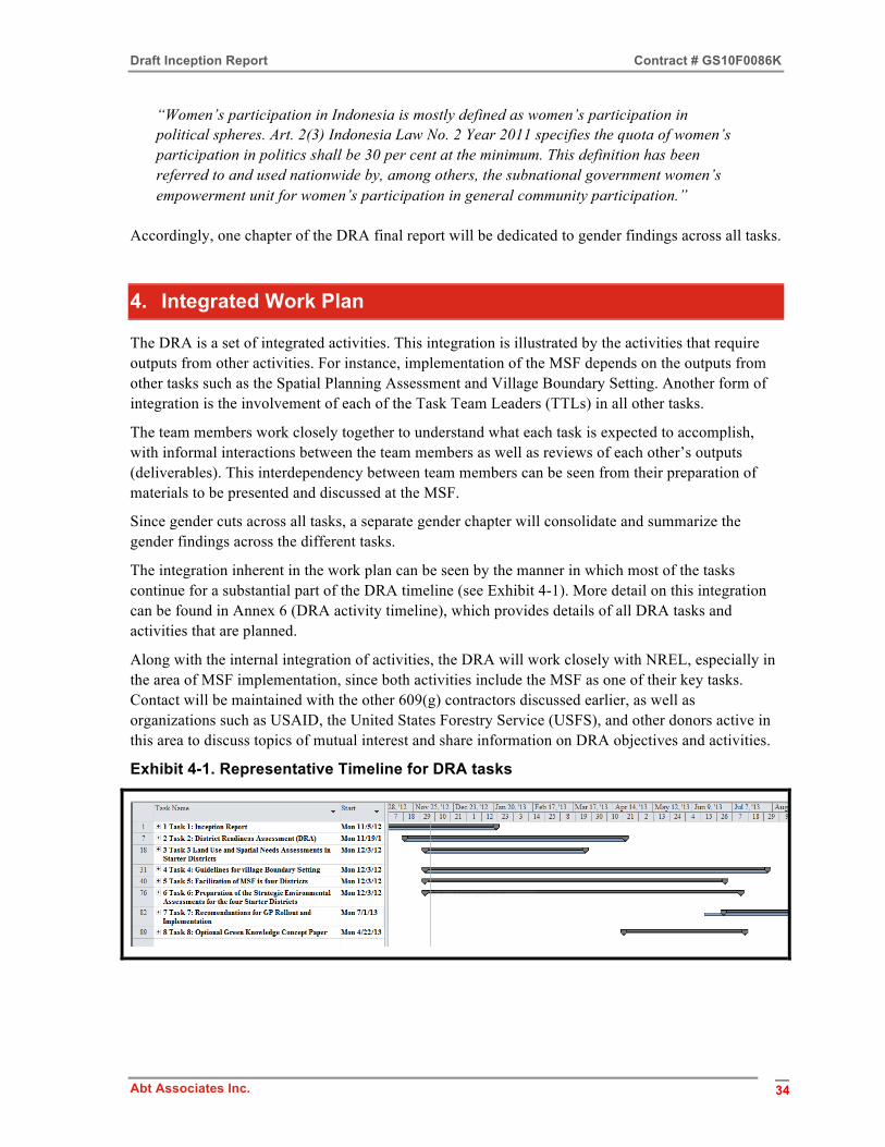
Draft Inception Report Contract # GS10F0086K
Abt Associates Inc. 34
“Women’s participation in Indonesia is mostly defined as women’s participation in political spheres. Art. 2(3) Indonesia Law No. 2 Year 2011 specifies the quota of women’s participation in politics shall be 30 per cent at the minimum. This definition has been referred to and used nationwide by, among others, the subnational government women’s empowerment unit for women’s participation in general community participation.”
Accordingly, one chapter of the DRA final report will be dedicated to gender findings across all tasks.
4. Integrated Work Plan
The DRA is a set of integrated activities. This integration is illustrated by the activities that require outputs from other activities. For instance, implementation of the MSF depends on the outputs from other tasks such as the Spatial Planning Assessment and Village Boundary Setting. Another form of integration is the involvement of each of the Task Team Leaders (TTLs) in all other tasks.
The team members work closely together to understand what each task is expected to accomplish, with informal interactions between the team members as well as reviews of each other’s outputs (deliverables). This interdependency between team members can be seen from their preparation of materials to be presented and discussed at the MSF.
Since gender cuts across all tasks, a separate gender chapter will consolidate and summarize the gender findings across the different tasks.
The integration inherent in the work plan can be seen by the manner in which most of the tasks continue for a substantial part of the DRA timeline (see Exhibit 4-1). More detail on this integration can be found in Annex 6 (DRA activity timeline), which provides details of all DRA tasks and activities that are planned.
Along with the internal integration of activities, the DRA will work closely with NREL, especially in the area of MSF implementation, since both activities include the MSF as one of their key tasks. Contact will be maintained with the other 609(g) contractors discussed earlier, as well as organizations such as USAID, the United States Forestry Service (USFS), and other donors active in this area to discuss topics of mutual interest and share information on DRA objectives and activities.
Exhibit 4-1. Representative Timeline for DRA tasks

Draft Inception Report Contract # GS10F0086K
Abt Associates Inc. 35
5. Project Organization
The DRA is establishing three offices to serve provincial, district, and national needs. Offices are being established at the provincial Bappeda offices in Jambi and West Sulawesi. This will encourage close coordination and cooperation with the provincial Bappeda offices, which will be working closely with the DRA to implement the activities in the four start-up districts – Muaro Jambi and Merangin in Jambi, and Mamuju and Mamasa in West Sulawesi. The Jambi office will be the technical hub for DRA team operations. The technical consultants will work out of Jambi to take advantage of the opportunities to be in contact with the many organizations and projects working on areas related to the GP project. With the districts in Jambi having had more past exposure to development projects, it is expected that information sources there will be better developed to support the information needs of the DRA. The experience in Jambi will be important in providing direction on the same activities being implemented in West Sulawesi.
The same activities will be carried out in both Jambi and West Sulawesi provinces. The office in Mamuju, West Sulawesi will support activities in the districts of Mamuju and Mamasa. Though there are not expected to be any long-term resident staff in Mamuju, DRA staff will make regular visits to West Sulawesi to ensure the successful completion of project activities.
A Jakarta office is also being established to serve the overall administrative needs of the project and ensure close interaction with the DRA stakeholders in the Jakarta area, especially MCI and MCC. The Jakarta office will also provide a space for consultants when they are attending meetings in Jakarta or in transit to West Sulawesi.
The organization of DRA is presented in the organization chart in Annex 7. This chart shows the technical division of the project, which is led by three Task Team Leaders (TTLs), as well as Johan Ceelen who has been tasked with directing the MSF activity. As part of the preliminary analysis, Abt concluded that given the importance of both the District Readiness Assessment and MSFs, the team should be restructured slightly in order to insure a senior expert is directly responsible for each as shown below in Exhibit 5-1. In addition, we have tasked Dr. Sulaiman with preparing recommendations and analysis on ICT and Knowledge Management issues, thus providing additional value-added to the program. In reviewing the DRA organization chart, please note that around half of Pak Novel Gofur’s time and half of the Local Liaison’s time will be applied to the MSF work being implemented under Johan Ceelen. So while the number of positions under MSF looks sparse, in practice there will be more staffing input for this task than it initially appears.
Exhibit 5-1. DRA Assignments
DRA Task Task Leader
District Screening and Prioritization Report Idris Sulaiman
Land Use and Spatial Planning Assessment Martua Sirait
Guidelines for Village Boundary Setting Martua Sirait Multi-Stakeholder Forums Johan Ceelen
Strategic Environmental Assessments Arief Wicaksono

Draft Inception Report Contract # GS10F0086K
Abt Associates Inc. 36
The TTLs are supported by short-term consultants, some of which are shown in the organization chart, while more will be added as additional consultant needs are identified (a process that is active and ongoing). Furthermore, Abt can and will draw on its local sub-contractors – ICRAF and URDI – for short term expertise, leadership, and insights into successful implementation in Indonesia. ICRAF will provide leadership on land-use planning and participatory boundary issues; access to Jambi infrastructure and experts; and assistance with the stakeholder forums. URDI will contribute on regional and local planning issues, stakeholder relations, and coordination with key national and sub-national counterparts, and will provide access to additional technical expertise.
6. Communications
Many kinds of institutions have an interest in the DRA activities. They include US Government agencies such as MCC, USAID, and the United States Department of Forestry, among others. As Indonesia is the recipient of the GP investments, the Indonesian government institutions related to this investment at the national, provincial, and district level need to know about and understand the DRA activities. Other interested stakeholders are other projects working in the same areas as DRA, and local NGOs. This section of the Inception Report is intended to indicate the approaches that DRA will be using to keep the many stakeholders informed and, to the extent needed, will also indicate the involvement of various stakeholders.
Communication networks
The networks and relationships that will be used to communicate the plans, activities, and results of DRA implementation are as follows:
• Consultations with MCC staff and consultants.
• Bi-weekly meetings with the CEO and technical leadership at MCA-I.
• Periodic meetings with NREL to coordinate our activities, especially for the MSFs (DRA Task 5) and also for DRA Task 2 (District selection criteria relating to renewable energy supply and demand estimates).
• Monthly meetings with provincial stakeholders in Jambi and West Sulawesi provinces. Coordination teams have already been formally established by the Governor of Jambi to discuss the expectations, activities, challenges, and results of MCC-funded projects.
• Monthly meetings with related stakeholders at the district level. There are plans to form coordination teams and working groups in all four districts participating in the DRA.
• Participation in meetings and events sponsored by other projects or organizations related to the objectives of the DRA.
• Consultations with related or relevant national government offices.
• The topic discussed at the meetings with MCI/MCA-I and the provincial and district coordination teams will be a report on DRA progress and challenges. Deliverables will generally be discussed at the district, province, and national levels (MCI/MCA-I and MCC), in that order. Beginning the deliverable discussions with the districts will allow the reviews and suggested changes from the districts to feed into the information contained in the deliverables.
Draft Inception Report Contract # GS10F0086K
Abt Associates Inc. 37
Geo-spatial working group
The idea of forming a geo-spatial working group was discussed with MCC and MCI during preliminary presentations and discussions. There are many institutions and organizations in Indonesia that use and generate geo-spatial data. The aim is to minimize the time, effort and cost expended in analyzing geo-spatial databases.
The geo-spatial working group will have the following tasks:
• Learn about the various activities being carried out using geo-spatial databases;
• Share databases that are open to the public and/or for which the GOI has granted permission to use;
• Share the results of the geo-spatial database analysis; and
• Find new applications for the use of geo-spatial databases.
The presence of a geo-spatial working group is valuable at both the national and the provincial level. Efforts will be made to form geo-spatial working groups in Jakarta, Jambi and Mamuju in West Sulawesi. A step towards the establishment of a geo-spatial working group in Jakarta was the DRA’s participation in the first meeting of an Open Source Initiative of Climate Change Governance facilitated by the DNPI (the National Council on Climate Change) office in Jakarta. Further discussions will be held with Farhan Helmy, Secretary of the Mitigation Working Group at DNPI, on how we can work together to bring other geo-spatial data users together for the purposes outlined above.
Follow-up visits to Jambi and West Sulawesi over the next two months will pursue the concept of provincial geo-spatial working groups in both provinces.
The DRA is contemplating several steps in relation to geo-spatial aspects of the activity:
• maintaining ongoing consultations with the UKP4 and the “One-Map” initiative on broad geo-spatial developments;
• maintaining a database of national GIS experts; and
• appointing a representative to report on key developments at the Open Source Initiative on Climate Change Governance forum, developments in spatial infrastructure research in the Asia-Pacific region, and key developments internationally in respect of Free Open Source Software (FOSS) GIS-related standard settings (including FOSS4G conferences, the (global) Open Geospatial Consortium, and others).
7. Reporting
Reporting DRA results involves two distinct channels – formal and informal. The formal channel is the submission of the contracted deliverables for Tasks 1 through 8. These deliverables are listed in Annex 8, which shows the task deliverable and the expected date of submission. These deliverables are the results that MCC and MCA-I expect to become an important set of inputs that will enable the Green Prosperity project to pursue investments to reduce poverty in ways that sustain natural

Draft Inception Report Contract # GS10F0086K
Abt Associates Inc. 38
resources for future generations and maintain the livelihoods of a large proportion of the population living in the rural areas of the targeted districts.
In the process of working on the deliverables, consultations will take place as outlined in the Communications section of this Inception Report. This interchange of information will bring the results of our work into the forums discussed in that section. These relatively informal forums are an important way to deliver the DRA results while also giving the Team useful input with which to improve these results.
Starting in January 2013, a weekly project newsletter will be prepared that contains information on activities during the past week and events, meetings, and travel planned for the following week. This DRA Newsletter will be distributed to MCC, MCA-I, and participating provinces and districts. The DRA Newsletter will also be distributed to government offices and organizations related to or interested in the DRA activity, and will be put on the MCA-I website.
8. Challenges
Management issues
The major challenge to management is to work with the staff to complete the activities and submit high quality deliverables in a timely manner within the very tight time constraints of the project. While preparing this draft Inception Report, the need to adjust some of the activities became clear as a consequence of those time constraints, as well as to maximize the appointment of new leadership at MCA-I. All adjustments are being carefully coordinated with MCC Project Monitors and do not impact the overall achievement of deliverables under the contract.
A related management issue is the capacity to have the required staff in place when they are needed. Having the right people to do the work is critical to achieving the expected results. This challenge will require the support and understanding of all consultants and the institutions they represent.
Keeping all staff aware of each other’s activities and conveying productive reviews and input to their colleagues is an important challenge for the DRA to resolve. With most staff in Jambi, and some working in West Sulawesi at any given time, the DRA will hold weekly staff meetings – either in person or through virtual meetings – to connect all staff in the three offices so that all staff stay informed of current and planned project activities. Monitoring the integrated work plan will also help us to direct project activities.
Maintaining the many relationships developed during implementation of the DRA will bring its own challenges in terms of the time required to carry out this important representational and management activity. For example, the need to work closely and coordinate with the NREL project has been identified as a critical relationship. We will work with the NREL project to make sure we clearly understand each other’s objectives, and the activities being undertaken to achieve those objectives. This commitment translates into frequent consultations between these two related projects to support the eventual implementation of the Green Prosperity project.
Logistical issues
The travel time and distance between the two starter provinces reduces the productive use of the consultants’ time. Moving from Jambi to Mamuju requires two days’ travel. Since there are no direct
Draft Inception Report Contract # GS10F0086K
Abt Associates Inc. 39
connections between these two provinces, transit is through Jakarta. The travel time between the two districts in each province is also a constraint. In Jambi, it takes around five hours to travel from Muaro Jambi to Merangin. In West Sulawesi, travel time between Mamuju and Mamasa is about 11 hours along very poor roads that may become impassable in heavy rain.
One step the DRA is taking in response to these logistical issues is to hire a part-time District Coordinator (DC) to work in those areas that require long travel times. We are presently recruiting a DC for Merangin and another for Mamasa. This will at least give us a conduit on the ground for information flow that can also help organize meetings and activities.
Information sources
Determining data needs is theoretically quite an easy task. But securing the data may not be so straightforward. The DRA is aware that there will be many challenges in obtaining reliable data to perform the analysis required to achieve the DRA activity outputs. Care must be taken to use data that is both representative and accurate. Lack of valid data will not only detract from the results, it also has the potential to give spurious results that make policy decisions impossible.
The data collected will need to be checked and rechecked at all levels of government, from the district to the provincial and national levels. Establishing the geo-spatial working groups at the district, province, and national levels should improve the data acquired and so improve the results of the analysis. Modern data sharing and managing techniques such as a client/stakeholder management system and a document management system will be considered by the DRA to enhance teamwork and the exchange of information with MCA-I, MCC and NREL.
Financial support for MSF
The MOUs signed by the provinces and districts indicate that the districts and/or provinces will provide the necessary financial support. MCA-I is currently clarifying he source and timeliness of this district/provincial government funding. This requests has been made orally at meetings with MCA-I.
Every effort will be made to overcome or minimize these challenges during implementation of the DRA to avoid delays in preparation of the outputs that are needed by the GP Program in order to achieve the key goals. Given the limited time available to implement the DRA activities, the management and consultants working on the DRA will need to monitor the challenges mentioned in this section (and others that may arise) and take appropriate action before they become critical impediments to the successful completion of the DRA objectives.
Establishment of coordination teams and working groups in starter districts
While Provincial Coordination Teams and Working Groups have been established in the two starter provinces, preparations for the establishment of the District Coordination Teams and Working Groups in all four starter districts are still ongoing. The DRA Team has been informed by all four starter districts that these District Coordination Teams and Working Groups will be formally established by the end of January 2013. It is important to clarify the role and tasks of these Provincial and District Coordination Teams and Working Groups, and whether they will receive funding in a timely fashion to ensure effective cooperation with the DRA/Abt and NREL Teams during this GP investment preparation phase.

Draft Inception Report Contract # GS10F0086K
Abt Associates Inc. 40
Annexes
1. Project meetings in October-November 2012
2. Preliminary list of materials collected
3. SMERU list of NGOs in Jambi and West Sulawesi
4. Potential MSF participants
5. Summary of selection criteria and entry screening criteria for GP Projects
6. DRA activity timeline
7. DRA organization chart
8. DRA deliverables
Draft Inception Report Contract # GS10F0086K
Abt Associates Inc. 41
Annex 1. Project meetings in October-November 2012
No Date Location Purpose Participants Jakarta 1. 23 October Jakarta, Bappenas
office Introductory meeting Mr. Lukita, Vice
Minister of Bappenas
2. 23 October Jakarta, at MC-I/ Bappenas Office
Program logistics and office preparation
MC-I/Bappenas team
3 1 November Mandarin Hotel Meeting MCC’s GP Team
4 2 November MC-I/Bappenas office
Introductory meeting Abt with MCC, NREL and MC-I/Bappenas
5 5 November MC-I/Bappenas office
Preparations for field visits to Jambi (Merangin and Muaro Jambi) and West Sulawesi (Mamuju and Mamasa) and introduction of Abt Team to candidate provinces and districts
MC-I/Bappenas
6 8 November Bappenas office MOU signing ceremony GP team and Bappenas
7 8 November Mandarin Hotel Meeting on MOU, coordinated by US State Department
Abt, NREL, IFACS and USAID
Jambi 1 7 November Jambi City Meetings Separate meetings
with NGO resource people
2 7 November Muaro District, Jambi Meeting 7 Representatives from district government agencies
3 8 November Merangin District Meeting 15 Representatives from key district government agencies, 1 university resource person
4 28 November Jambi Province Separate Meetings Mr. Fauzi Anshori (Head of Provincial Bappeda) Mr. Risno Murti Chandra (BPPHP) Mr. Rudisyaf (WARSI NGO) Mr. Ridwansyah (University of Jambi)

Draft Inception Report Contract # GS10F0086K
Abt Associates Inc. 42
West Sulawesi 1 20 November West Sulawesi
Province Meeting 18 Representatives
from key provincial government agencies
2 20 November Mamuju District Meeting 11 representatives from key district government agencies
3 22 November Mamasa District Meeting 18 representatives from key district government agencies, 1 NGO representative
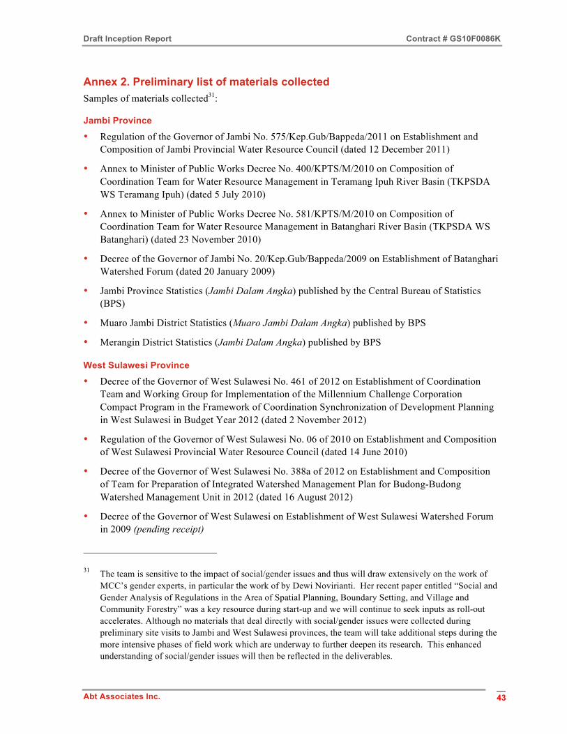
Draft Inception Report Contract # GS10F0086K
Abt Associates Inc. 43
Annex 2. Preliminary list of materials collected Samples of materials collected31:
Jambi Province
• Regulation of the Governor of Jambi No. 575/Kep.Gub/Bappeda/2011 on Establishment and Composition of Jambi Provincial Water Resource Council (dated 12 December 2011)
• Annex to Minister of Public Works Decree No. 400/KPTS/M/2010 on Composition of Coordination Team for Water Resource Management in Teramang Ipuh River Basin (TKPSDA WS Teramang Ipuh) (dated 5 July 2010)
• Annex to Minister of Public Works Decree No. 581/KPTS/M/2010 on Composition of Coordination Team for Water Resource Management in Batanghari River Basin (TKPSDA WS Batanghari) (dated 23 November 2010)
• Decree of the Governor of Jambi No. 20/Kep.Gub/Bappeda/2009 on Establishment of Batanghari Watershed Forum (dated 20 January 2009)
• Jambi Province Statistics (Jambi Dalam Angka) published by the Central Bureau of Statistics (BPS)
• Muaro Jambi District Statistics (Muaro Jambi Dalam Angka) published by BPS
• Merangin District Statistics (Jambi Dalam Angka) published by BPS
West Sulawesi Province
• Decree of the Governor of West Sulawesi No. 461 of 2012 on Establishment of Coordination Team and Working Group for Implementation of the Millennium Challenge Corporation Compact Program in the Framework of Coordination Synchronization of Development Planning in West Sulawesi in Budget Year 2012 (dated 2 November 2012)
• Regulation of the Governor of West Sulawesi No. 06 of 2010 on Establishment and Composition of West Sulawesi Provincial Water Resource Council (dated 14 June 2010)
• Decree of the Governor of West Sulawesi No. 388a of 2012 on Establishment and Composition of Team for Preparation of Integrated Watershed Management Plan for Budong-Budong Watershed Management Unit in 2012 (dated 16 August 2012)
• Decree of the Governor of West Sulawesi on Establishment of West Sulawesi Watershed Forum in 2009 (pending receipt)
31 The team is sensitive to the impact of social/gender issues and thus will draw extensively on the work of MCC’s gender experts, in particular the work of by Dewi Novirianti. Her recent paper entitled “Social and Gender Analysis of Regulations in the Area of Spatial Planning, Boundary Setting, and Village and Community Forestry” was a key resource during start-up and we will continue to seek inputs as roll-out accelerates. Although no materials that deal directly with social/gender issues were collected during preliminary site visits to Jambi and West Sulawesi provinces, the team will take additional steps during the more intensive phases of field work which are underway to further deepen its research. This enhanced understanding of social/gender issues will then be reflected in the deliverables.

Draft Inception Report Contract # GS10F0086K
Abt Associates Inc. 44
Mamuju District
• Decree on Mamuju Watershed Forum (pending receipt)
• List of NGOs registered at Mamuju National Unity Agency (“Kesatuan Bangsa”) (pending receipt)
Mamasa District
• Annex to Minister of Public Works Decree No. 80/KPTS/M/2011 on Composition of Coordination Team for Water Resource Management in Saddang River Basin (TKPSDA WS Saddang) (dated 28 March 2011)
• List of NGOs registered at Mamasa District “National Unity” Agency (“Kesatuan Bangsa”) in the years 2007 (13 NGOs), 2008 (19 NGOs), 2011/2012 (4 NGOs)
Nationwide (including Jambi and West Sulawesi)
• The currently established Coordination Teams for Management of Water Resources for National Strategic River Basins (TKPSDA WS Strategis Nasional)
• Overview of currently established Provincial Water Resource Councils (Dewan Sumber Daya Air Propinsi) and Coordination Teams for Management of Water Resources for Cross-Provincial River Basins (TKPSDA WS Lintas Propinsi)
• Overview with status of drafting masterplan (Pola) and water resources management plan for river basins under the authority/responsibility of the central government (Penyusunan Rancangan Pola dan Rencana Pengelolaan SDA Wilayah Sungai) (status of 63 river basins managed by 32 national-level River Basin Centers, known as BBWS)
• Guidelines for Preparing/Drafting Integrated Watershed Management Plans (Annex to Minister of Forestry Regulation No. P.39/Menhut-II/2009 dated June 12, 2009)
• The Asia Foundation/Regional Autonomy Watch (KPPOD) – (i) Indonesia Local Economic Governance Index, 2007, looking at the dynamics of local governance and business development in 243 districts in Indonesia after nearly a decade of regional autonomy; and (ii) Local Economic Governance: A Survey of Business Operators in 245 Districts/Municipalities in Indonesia, 2011, looking at the quality of local economic governance (LEG) in 245 districts in 19 provinces
• AusTrade (April 2012) – “Trade opportunities in the low emissions technology and services sector in Indonesia”

Draft Inception Report Contract # GS10F0086K
Abt Associates Inc. 45
Annex 3. SMERU list of NGOs in Jambi and West Sulawesi
A. Jambi
No. Name of organization Address and contact details
1. Aliansi Masyarakat Adat Nusantara Jambi (AMAN Jambi)
Usman Gumanti Jl. Dara Jingga no.49 Jambi 36143 Jambi Ph: 0741- 21912 Fax: 0741 - 24528
2. Aliansi Masyarakat Peduli Hutan dan Lahan (AMPHAL)
Adhietya Noegraha Jl. Jend Sudirman Komplek BBC Blok B 11 Batanghari Jambi Jambi Ph: 0743-22695; 08127408500 Fax: 0743-22695 E-mail: [email protected]
3. Balai Taman Nasional Kerinci Seblat (BTNKS)
Jl.Basuki Rahmat No.11 Po Box 40 Sungai Penuh Kerinci 37101 Jambi Ph: 0748-22250 Fax: 0748-223001
4. Bina Sumber Daya Manusia (Bina SDM)
Aswan Jl. Haji Kamil ni.11 Kel. Wijaya Pura Kec. Jambi Selatan Jambi Jambi Ph: 0741-32640 Fax: 0741-32640
5. Gita Buana Club (YGB)
Jl. Patimura Lrg H. Ibrahim No.85 Rt22/01 Kel. Rawa Sari Kec. Kota Baru Jambi 36126 Jambi Ph: 0741-667560 E-mail: [email protected] Web: http://members.ncbi.com/gitabuana
6. Kantor Bantuan Hukum Jambi (KBH-Jambi)
Irfan Perum Unja no. 16B Telanai Pura Jl. Haji Manaf Jambi Jambi Ph: 0741-61374
7. Komunitas Konservasi Indonesia - Warsi (KKI-WARSI)
Rahmat Hidayat Jl. Raden Inu Kertapati no.12 Rt.10 Komp. DPRD Kel. Pematang Sulur Kec. Telanaipura Jambi 36124 Jambi Ph: 0741-66678; 66695; 08127824660 Fax: 0741- 670509
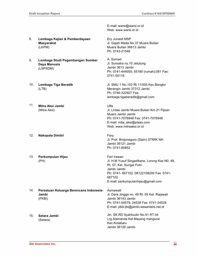
Draft Inception Report Contract # GS10F0086K
Abt Associates Inc. 46
E-mail: [email protected] Web: www.warsi.or.id
8. Lembaga Kajian & Pemberdayaan Masyarakat (LKPM)
Ery Junaidi MSP Jl. Gajah Mada No.37 Muara Bulian Muara Bulian 36613 Jambi Ph: 0743-21546
9. Lembaga Studi Pegembangan Sumber Daya Manusia (LSPSDM)
A. Somad Jl. Sumatra no.10 Jelutung Jambi 3613 Jambi Ph: 0741-444055; 55180 (rumah);081 Fax: 0741-55116
10. Lembaga Tiga Beradik (LTB)
Jl. SMU 1 No.102 Rt.11/005 Kec.Bangko Merangin Jambi 37312 Jambi Ph: 0746-322927 Fax: [email protected]
11. Mitra Aksi Jambi (Mitra Aksi)
Ulfa Jl. Lintas Jambi Muara Bulian Km 21 Pijoan Muaro Jambi Jambi Ph: 0741-7076948 Fax: 0741-7076948 E-mail: [email protected] Web: www.mitraaksi.or.id
12. Nakopala Dimitri Fery Jl. Prof. Brojonegoro (Sipin) STMIK NH Jambi 36121 Jambi Ph: 0741-60852
13. Perkumpulan Hijau (PH)
Feri Irawan Jl. H.M Yusuf Singadikane, Lorong Kas N0. 48, Rt. 07, Kel. Sungai Putri Jambi Jambi Ph: 0741- 667102 ;08122108200 Fax: 0741- 667102 E-mail: [email protected]
14. Persatuan Keluarga Berencana Indonesia- Jambi (PKBI)
Asmawati Jl. Dara Jingga no. 49 Rt. 05 Kel. Rajawali Jambi 36143 Jambi Ph: 0741-54579, 24528 Fax: 0741-24528 E-mail: [email protected]
15. Setara Jambi (Setara)
Jln. SK.RD Syahbudin No.91 RT.04 Lrg.Alamanda Kel.Mayang mangurai Kec.Kotabaru Jambi 36126 Jambi
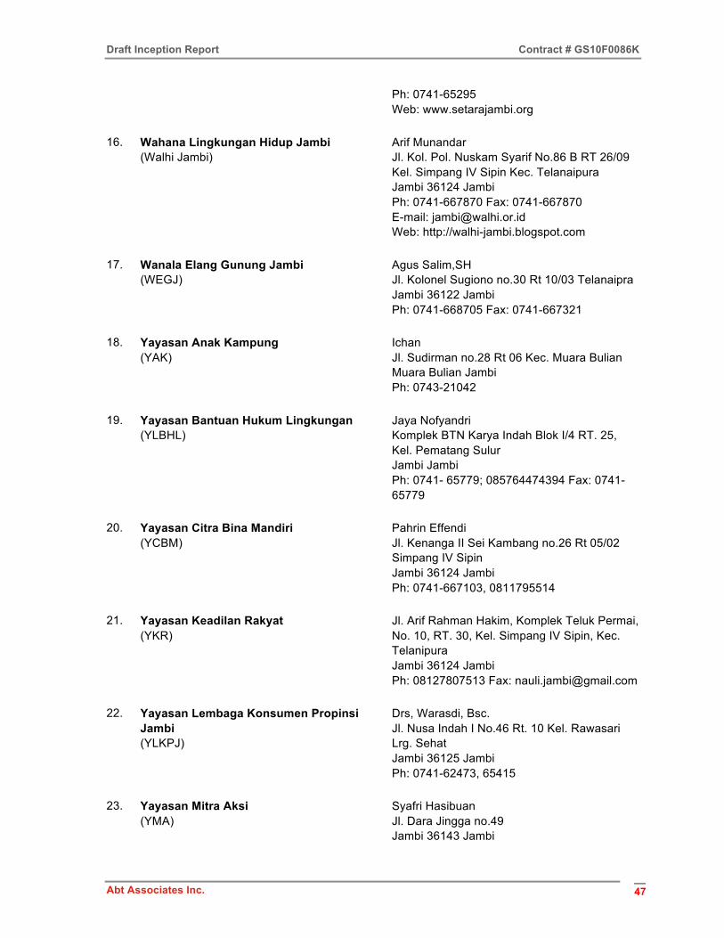
Draft Inception Report Contract # GS10F0086K
Abt Associates Inc. 47
Ph: 0741-65295 Web: www.setarajambi.org
16. Wahana Lingkungan Hidup Jambi (Walhi Jambi)
Arif Munandar Jl. Kol. Pol. Nuskam Syarif No.86 B RT 26/09 Kel. Simpang IV Sipin Kec. Telanaipura Jambi 36124 Jambi Ph: 0741-667870 Fax: 0741-667870 E-mail: [email protected] Web: http://walhi-jambi.blogspot.com
17. Wanala Elang Gunung Jambi (WEGJ)
Agus Salim,SH Jl. Kolonel Sugiono no.30 Rt 10/03 Telanaipra Jambi 36122 Jambi Ph: 0741-668705 Fax: 0741-667321
18. Yayasan Anak Kampung (YAK)
Ichan Jl. Sudirman no.28 Rt 06 Kec. Muara Bulian Muara Bulian Jambi Ph: 0743-21042
19. Yayasan Bantuan Hukum Lingkungan (YLBHL)
Jaya Nofyandri Komplek BTN Karya Indah Blok I/4 RT. 25, Kel. Pematang Sulur Jambi Jambi Ph: 0741- 65779; 085764474394 Fax: 0741-65779
20. Yayasan Citra Bina Mandiri (YCBM)
Pahrin Effendi Jl. Kenanga II Sei Kambang no.26 Rt 05/02 Simpang IV Sipin Jambi 36124 Jambi Ph: 0741-667103, 0811795514
21. Yayasan Keadilan Rakyat (YKR)
Jl. Arif Rahman Hakim, Komplek Teluk Permai, No. 10, RT. 30, Kel. Simpang IV Sipin, Kec. Telanipura Jambi 36124 Jambi Ph: 08127807513 Fax: [email protected]
22. Yayasan Lembaga Konsumen Propinsi Jambi (YLKPJ)
Drs, Warasdi, Bsc. Jl. Nusa Indah I No.46 Rt. 10 Kel. Rawasari Lrg. Sehat Jambi 36125 Jambi Ph: 0741-62473, 65415
23. Yayasan Mitra Aksi (YMA)
Syafri Hasibuan Jl. Dara Jingga no.49 Jambi 36143 Jambi
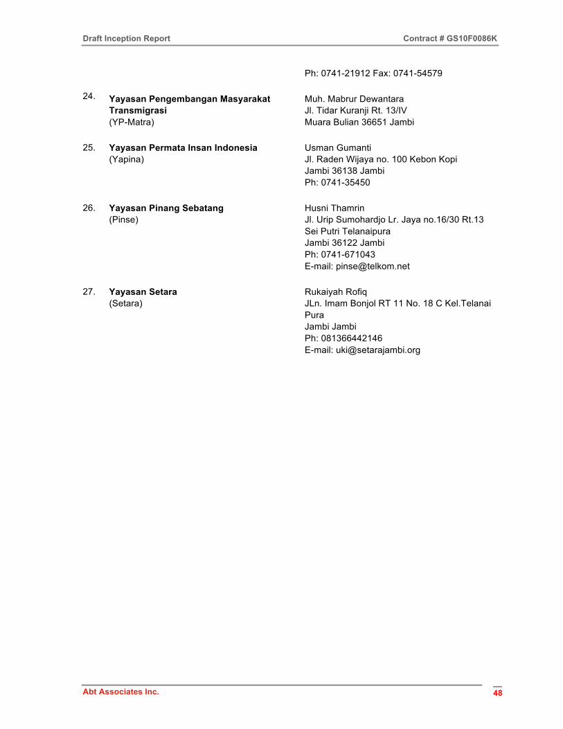
Draft Inception Report Contract # GS10F0086K
Abt Associates Inc. 48
Ph: 0741-21912 Fax: 0741-54579
24. Yayasan Pengembangan Masyarakat Transmigrasi (YP-Matra)
Muh. Mabrur Dewantara Jl. Tidar Kuranji Rt. 13/IV Muara Bulian 36651 Jambi
25. Yayasan Permata Insan Indonesia (Yapina)
Usman Gumanti Jl. Raden Wijaya no. 100 Kebon Kopi Jambi 36138 Jambi Ph: 0741-35450
26. Yayasan Pinang Sebatang (Pinse)
Husni Thamrin Jl. Urip Sumohardjo Lr. Jaya no.16/30 Rt.13 Sei Putri Telanaipura Jambi 36122 Jambi Ph: 0741-671043 E-mail: [email protected]
27. Yayasan Setara (Setara)
Rukaiyah Rofiq JLn. Imam Bonjol RT 11 No. 18 C Kel.Telanai Pura Jambi Jambi Ph: 081366442146 E-mail: [email protected]
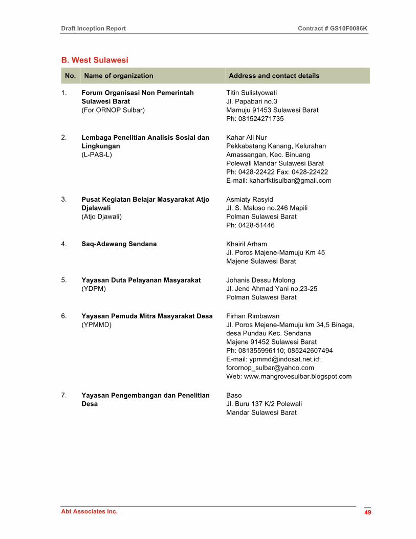
Draft Inception Report Contract # GS10F0086K
Abt Associates Inc. 49
B. West Sulawesi
No. Name of organization Address and contact details
1. Forum Organisasi Non Pemerintah Sulawesi Barat (For ORNOP Sulbar)
Titin Sulistyowati Jl. Papabari no.3 Mamuju 91453 Sulawesi Barat Ph: 081524271735
2. Lembaga Penelitian Analisis Sosial dan Lingkungan (L-PAS-L)
Kahar Ali Nur Pekkabatang Kanang, Kelurahan Amassangan, Kec. Binuang Polewali Mandar Sulawesi Barat Ph: 0428-22422 Fax: 0428-22422 E-mail: [email protected]
3. Pusat Kegiatan Belajar Masyarakat Atjo Djalawali (Atjo Djawali)
Asmiaty Rasyid Jl. S. Maloso no.246 Mapili Polman Sulawesi Barat Ph: 0428-51446
4. Saq-Adawang Sendana Khairil Arham Jl. Poros Majene-Mamuju Km 45 Majene Sulawesi Barat
5. Yayasan Duta Pelayanan Masyarakat (YDPM)
Johanis Dessu Molong Jl. Jend Ahmad Yani no,23-25 Polman Sulawesi Barat
6. Yayasan Pemuda Mitra Masyarakat Desa (YPMMD)
Firhan Rimbawan Jl. Poros Mejene-Mamuju km 34,5 Binaga, desa Pundau Kec. Sendana Majene 91452 Sulawesi Barat Ph: 081355996110; 085242607494 E-mail: [email protected]; [email protected] Web: www.mangrovesulbar.blogspot.com
7. Yayasan Pengembangan dan Penelitian Desa
Baso Jl. Buru 137 K/2 Polewali Mandar Sulawesi Barat
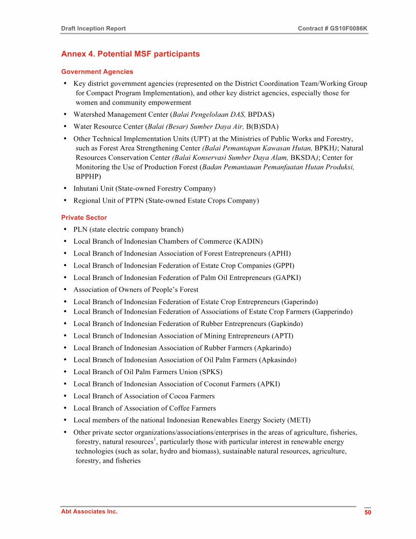
Draft Inception Report Contract # GS10F0086K
Abt Associates Inc. 50
Annex 4. Potential MSF participants
Government Agencies
• Key district government agencies (represented on the District Coordination Team/Working Group for Compact Program Implementation), and other key district agencies, especially those for women and community empowerment
• Watershed Management Center (Balai Pengelolaan DAS, BPDAS)
• Water Resource Center (Balai (Besar) Sumber Daya Air, B(B)SDA)
• Other Technical Implementation Units (UPT) at the Ministries of Public Works and Forestry, such as Forest Area Strengthening Center (Balai Pemantapan Kawasan Hutan, BPKH); Natural Resources Conservation Center (Balai Konservasi Sumber Daya Alam, BKSDA); Center for Monitoring the Use of Production Forest (Badan Pemantauan Pemanfaatan Hutan Produksi, BPPHP)
• Inhutani Unit (State-owned Forestry Company)
• Regional Unit of PTPN (State-owned Estate Crops Company)
Private Sector
• PLN (state electric company branch) • Local Branch of Indonesian Chambers of Commerce (KADIN)
• Local Branch of Indonesian Association of Forest Entrepreneurs (APHI)
• Local Branch of Indonesian Federation of Estate Crop Companies (GPPI)
• Local Branch of Indonesian Federation of Palm Oil Entrepreneurs (GAPKI) • Association of Owners of People’s Forest
• Local Branch of Indonesian Federation of Estate Crop Entrepreneurs (Gaperindo) • Local Branch of Indonesian Federation of Associations of Estate Crop Farmers (Gapperindo)
• Local Branch of Indonesian Federation of Rubber Entrepreneurs (Gapkindo)
• Local Branch of Indonesian Association of Mining Entrepreneurs (APTI)
• Local Branch of Indonesian Association of Rubber Farmers (Apkarindo) • Local Branch of Indonesian Association of Oil Palm Farmers (Apkasindo)
• Local Branch of Oil Palm Farmers Union (SPKS)
• Local Branch of Indonesian Association of Coconut Farmers (APKI)
• Local Branch of Association of Cocoa Farmers
• Local Branch of Association of Coffee Farmers • Local members of the national Indonesian Renewables Energy Society (METI)
• Other private sector organizations/associations/enterprises in the areas of agriculture, fisheries, forestry, natural resources1, particularly those with particular interest in renewable energy technologies (such as solar, hydro and biomass), sustainable natural resources, agriculture, forestry, and fisheries

Draft Inception Report Contract # GS10F0086K
Abt Associates Inc. 51
Existing Forums and Councils
• Watershed Forums (Forum DAS) (only if relevant to GP investment area) • (Provincial/District) Water Resources Council (Dewan Sumber Daya Air)
• Coordination Team for Water Resource Management (TKPSDA) for River Basin(s) concerned (only if relevant to GP investment area)
• District Forum of Village Heads
• Other relevant existing forums
Non-Government Organizations/Agencies
• Customary (adat) groups/organizations, especially from targeted GP investment areas • Farmer/Fishermen groups/organizations/associations, especially from targeted GP investment
areas • Women’s organizations (especially from targeted GP investment areas), such as the local branch
of the Women’s Alliance, local branch of Women’s Organizations (GOW), local members of Association for Assistance to Women in Small Business (ASSPUK), local branch of Indonesian Association of Women Entrepreneurs (IWAPI), local members of National Council of Indonesian Women’s Organization (KOWANI), local branch/members of Indonesian Women’s Coalition
• Organizations of other vulnerable groups, especially from targeted GP investment areas • Other community-based organizations • Relevant local, regional, and international NGOs2
• Other civil society groups, particularly those with a particular interest in renewable energy technologies and NRM projects
• Universities and technical schools3 Notes 1 Some additional associations of estate crop enterprises and farmers have been identified 2 Preliminary lists of NGOs identified in the two starter provinces are available on request. It is
envisaged that a list of NGOs, private sector organizations, community-based organizations, etc., will be available for each province and for each starter district by the end of January 2013.
3 Whether universities will be members of the MSF or attend as resource persons and/or observers requires further discussion.
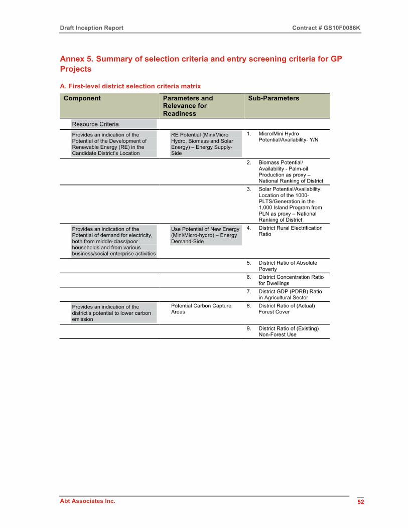
Draft Inception Report Contract # GS10F0086K
Abt Associates Inc. 52
Annex 5. Summary of selection criteria and entry screening criteria for GP Projects
A. First-level district selection criteria matrix
Component Parameters and Relevance for Readiness
Sub-Parameters
Resource Criteria
Provides an indication of the Potential of the Development of Renewable Energy (RE) in the Candidate District’s Location
RE Potential (Mini/Micro Hydro, Biomass and Solar Energy) – Energy Supply-Side
1. Micro/Mini Hydro Potential/Availability- Y/N
2. Biomass Potential/ Availability - Palm-oil Production as proxy – National Ranking of District
3. Solar Potential/Availability: Location of the 1000- PLTS/Generation in the 1,000 Island Program from PLN as proxy – National Ranking of District
Provides an indication of the Potential of demand for electricity, both from middle-class/poor households and from various business/social-enterprise activities
Use Potential of New Energy (Mini/Micro-hydro) – Energy Demand-Side
4. District Rural Electrification Ratio
5. District Ratio of Absolute Poverty
6. District Concentration Ratio for Dwellings
7. District GDP (PDRB) Ratio in Agricultural Sector
Provides an indication of the district’s potential to lower carbon emission
Potential Carbon Capture Areas
8. District Ratio of (Actual) Forest Cover
9. District Ratio of (Existing) Non-Forest Use
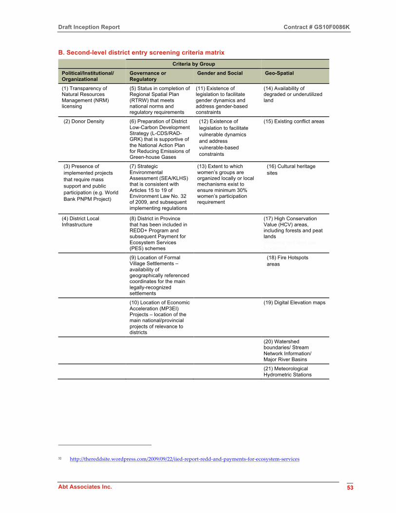
Draft Inception Report Contract # GS10F0086K
Abt Associates Inc. 53
B. Second-level district entry screening criteria matrix Criteria by Group
Political/Institutional/ Organizational
Governance or Regulatory
Gender and Social Geo-Spatial
(1) Transparency of Natural Resources Management (NRM) licensing
(5) Status in completion of Regional Spatial Plan (RTRW) that meets national norms and regulatory requirements
(11) Existence of legislation to facilitate gender dynamics and address gender-based constraints
(14) Availability of degraded or underutilized land
(2) Donor Density
(6) Preparation of District Low-Carbon Development Strategy (L-CDS/RAD-GRK) that is supportive of the National Action Plan for Reducing Emissions of Green-house Gases
(12) Existence of legislation to facilitate vulnerable dynamics and address vulnerable-based constraints
(15) Existing conflict areas
(3) Presence of implemented projects that require mass support and public participation (e.g. World Bank PNPM Project)
(7) Strategic Environmental Assessment (SEA/KLHS) that is consistent with Articles 15 to 19 of Environment Law No. 32 of 2009, and subsequent implementing regulations
(13) Extent to which women’s groups are organized locally or local mechanisms exist to ensure minimum 30% women’s participation requirement
(16) Cultural heritage sites
(4) District Local Infrastructure
(8) District in Province that has been included in REDD+ Program and subsequent Payment for Ecosystem Services (PES) schemes32
(17) High Conservation Value (HCV) areas, including forests and peat lands (biophysical presence and land use functions)
(9) Location of Formal Village Settlements – availability of geographically referenced coordinates for the main legally-recognized settlements
(18) Fire Hotspots areas
(10) Location of Economic Acceleration (MP3EI) Projects – location of the main national/provincial projects of relevance to districts
(19) Digital Elevation maps
(20) Watershed boundaries/ Stream Network Information/ Major River Basins
(21) Meteorological Hydrometric Stations
32 http://thereddsite.wordpress.com/2009/09/22/iied-‐‑report-‐‑redd-‐‑and-‐‑payments-‐‑for-‐‑ecosystem-‐‑services
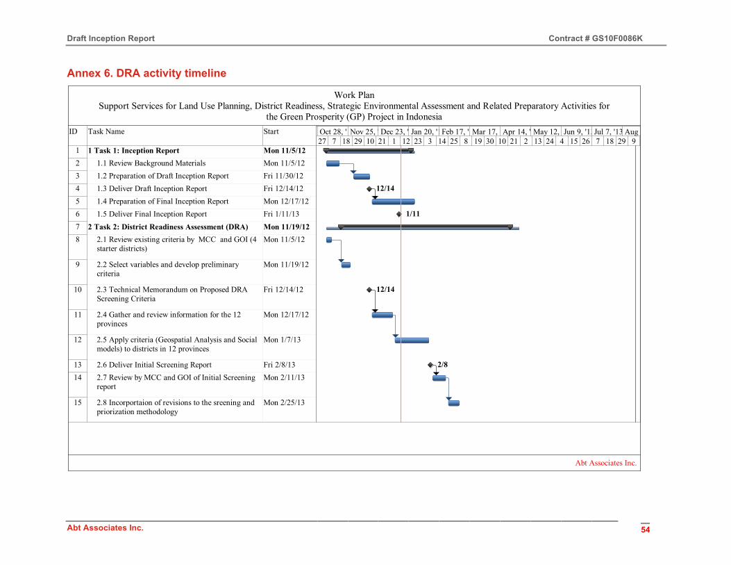
Draft Inception Report Contract # GS10F0086K
Abt Associates Inc. 54
Annex 6. DRA activity timeline
ID Task Name Start
1 1 Task 1: Inception Report Mon 11/5/122 1.1 Review Background Materials Mon 11/5/123 1.2 Preparation of Draft Inception Report Fri 11/30/124 1.3 Deliver Draft Inception Report Fri 12/14/125 1.4 Preparation of Final Inception Report Mon 12/17/126 1.5 Deliver Final Inception Report Fri 1/11/137 2 Task 2: District Readiness Assessment (DRA) Mon 11/19/128 2.1 Review existing criteria by MCC and GOI (4
starter districts)Mon 11/5/12
9 2.2 Select variables and develop preliminary criteria
Mon 11/19/12
10 2.3 Technical Memorandum on Proposed DRA Screening Criteria
Fri 12/14/12
11 2.4 Gather and review information for the 12 provinces
Mon 12/17/12
12 2.5 Apply criteria (Geospatial Analysis and Social models) to districts in 12 provinces
Mon 1/7/13
13 2.6 Deliver Initial Screening Report Fri 2/8/1314 2.7 Review by MCC and GOI of Initial Screening
reportMon 2/11/13
15 2.8 Incorportaion of revisions to the sreening and priorization methodology
Mon 2/25/13
12/14
1/11
12/14
2/8
27 7 18 29 10 21 1 12 23 3 14 25 8 19 30 10 21 2 13 24 4 15 26 7 18 29 9Sep 30, '12Oct 28, '12Nov 25, '12Dec 23, '12Jan 20, '13Feb 17, '13Mar 17, '13Apr 14, '13May 12, '13Jun 9, '13Jul 7, '13 Aug 4, '13
Work PlanSupport Services for Land Use Planning, District Readiness, Strategic Environmental Assessment and Related Preparatory Activities for
the Green Prosperity (GP) Project in Indonesia
Abt Associates Inc.
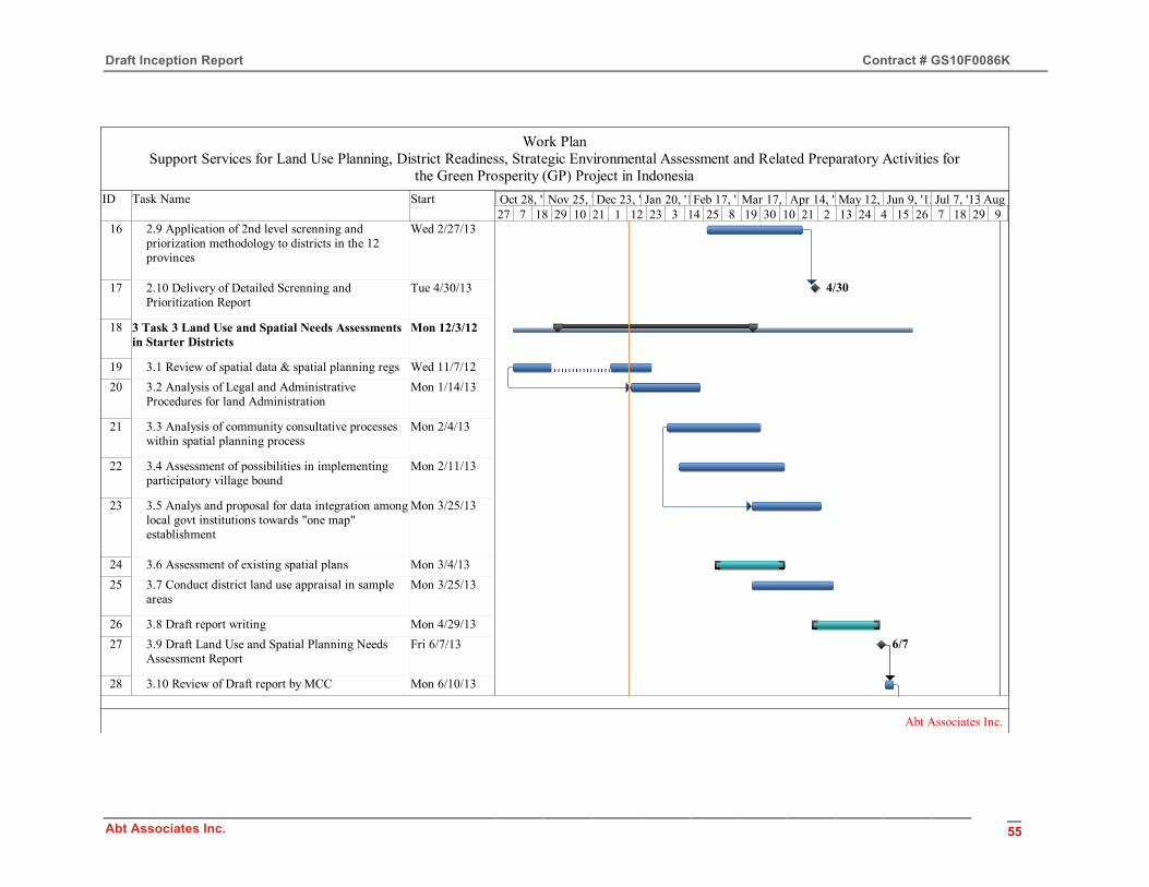
Draft Inception Report Contract # GS10F0086K
Abt Associates Inc. 55
ID Task Name Start
16 2.9 Application of 2nd level screnning and priorization methodology to districts in the 12 provinces
Wed 2/27/13
17 2.10 Delivery of Detailed Screnning and Prioritization Report
Tue 4/30/13
18 3 Task 3 Land Use and Spatial Needs Assessments in Starter Districts
Mon 12/3/12
19 3.1 Review of spatial data & spatial planning regs Wed 11/7/1220 3.2 Analysis of Legal and Administrative
Procedures for land AdministrationMon 1/14/13
21 3.3 Analysis of community consultative processes within spatial planning process
Mon 2/4/13
22 3.4 Assessment of possibilities in implementing participatory village bound
Mon 2/11/13
23 3.5 Analys and proposal for data integration amonglocal govt institutions towards "one map" establishment
Mon 3/25/13
24 3.6 Assessment of existing spatial plans Mon 3/4/1325 3.7 Conduct district land use appraisal in sample
areasMon 3/25/13
26 3.8 Draft report writing Mon 4/29/1327 3.9 Draft Land Use and Spatial Planning Needs
Assessment ReportFri 6/7/13
28 3.10 Review of Draft report by MCC Mon 6/10/13
4/30
6/7
27 7 18 29 10 21 1 12 23 3 14 25 8 19 30 10 21 2 13 24 4 15 26 7 18 29 9Sep 30, '12Oct 28, '12Nov 25, '12Dec 23, '12Jan 20, '13Feb 17, '13Mar 17, '13Apr 14, '13May 12, '13Jun 9, '13Jul 7, '13 Aug 4, '13
Work PlanSupport Services for Land Use Planning, District Readiness, Strategic Environmental Assessment and Related Preparatory Activities for
the Green Prosperity (GP) Project in Indonesia
Abt Associates Inc.

Draft Inception Report Contract # GS10F0086K
Abt Associates Inc. 56
ID Task Name Start
29 3.11 Revision of the Draft Report Mon 6/17/1330 3.12 Delivery of Final Land Use and Spatial
Planning Needs Assessment ReportWed 6/26/13
31 4 Task 4: Guidelines for village Boundary Setting Mon 12/3/12
32 4.1 Identification of district experienced community and NGOS in Village-Boundary Setting
Mon 1/7/13
33 4.2 Draft Guidelines prepared for presentation at MSF
Mon 2/18/13
34 4.3 Workshop/Meetings with experts and authorities to develop district guidelines
Tue 1/15/13
35 4.4 Consultation of Guidelines at the MSFs Mon 3/4/1336 4.5 Finalization of guidelines Mon 4/1/1337 4.6 Draft Guidelines submitted Fri 5/10/1338 4.7 Revisions made to finalize Guidelines Mon 5/13/1339 4.8 Final Guidelines Fri 6/7/1340 4.9 Facilitation of adoption of guidelines by
districtsFri 6/7/13
41 5 Task 5: Facilitation of MSF is four Districts Mon 12/3/1242 5.1 Establishment of membership of MSF Mon 12/3/1243 5.1.1 Identification and determination of key
stakeholder categoriesMon 12/3/12
6/26
5/10
6/7
27 7 18 29 10 21 1 12 23 3 14 25 8 19 30 10 21 2 13 24 4 15 26 7 18 29 9Sep 30, '12Oct 28, '12Nov 25, '12Dec 23, '12Jan 20, '13Feb 17, '13Mar 17, '13Apr 14, '13May 12, '13Jun 9, '13Jul 7, '13 Aug 4, '13
Work PlanSupport Services for Land Use Planning, District Readiness, Strategic Environmental Assessment and Related Preparatory Activities for
the Green Prosperity (GP) Project in Indonesia
Abt Associates Inc.

Draft Inception Report Contract # GS10F0086K
Abt Associates Inc. 57
ID Task Name Start
44 5.1.2 Identification of Potential key stakeholdersper category
Mon 12/10/12
45 5.1.3 Establish Criteria and mechanisms for selection
Mon 12/10/12
46 5.1.4 Etablish MSF membership per district Mon 12/31/1247 5.2 First round MSF Mon 1/28/1348 5.2.1 Planning MSF-1 activities Mon 1/28/1349 5.2.1.1 Identify/analyze forum needs for MSF-1Mon 1/28/1350 5.2.1.2 Prepare program and TOR for MSF-1 Mon 2/11/1351 5.2.1.3 Prepare detailed budget estimates for
MSF-1Mon 2/11/13
52 5.2.2 Preparation of MSF implementation Mon 1/28/1353 5.2.2.1 Prepare materials for MSF-1 Mon 2/18/1354 5.2.2.2 Identify, select, and determine
facilitators & resource persons for MSF-1Mon 1/28/13
55 5.2.3 First round MSF implementation Mon 3/4/1356 5.2.3.1 1st Round MSF for District #1 Mon 3/4/1357 5.2.3.2 1st Round MSF for District #2 Mon 3/11/1358 5.2.3.3 1st Round MSF for District #3 Mon 3/18/1359 5.2.3.4 1st Round MSF for District #4 Mon 3/25/1360 5.2.3.5 MSF District & Summary ReportMon 4/15/1361 5.3 Second round MSF Mon 4/1/1362 5.3.1 Planning MSF-2 Activities Mon 4/1/1363 5.3.1.1 Identify/analyze forum needs for MSF-2Mon 4/1/13
4/15
27 7 18 29 10 21 1 12 23 3 14 25 8 19 30 10 21 2 13 24 4 15 26 7 18 29 9Sep 30, '12Oct 28, '12Nov 25, '12Dec 23, '12Jan 20, '13Feb 17, '13Mar 17, '13Apr 14, '13May 12, '13Jun 9, '13Jul 7, '13 Aug 4, '13
Work PlanSupport Services for Land Use Planning, District Readiness, Strategic Environmental Assessment and Related Preparatory Activities for
the Green Prosperity (GP) Project in Indonesia
Abt Associates Inc.
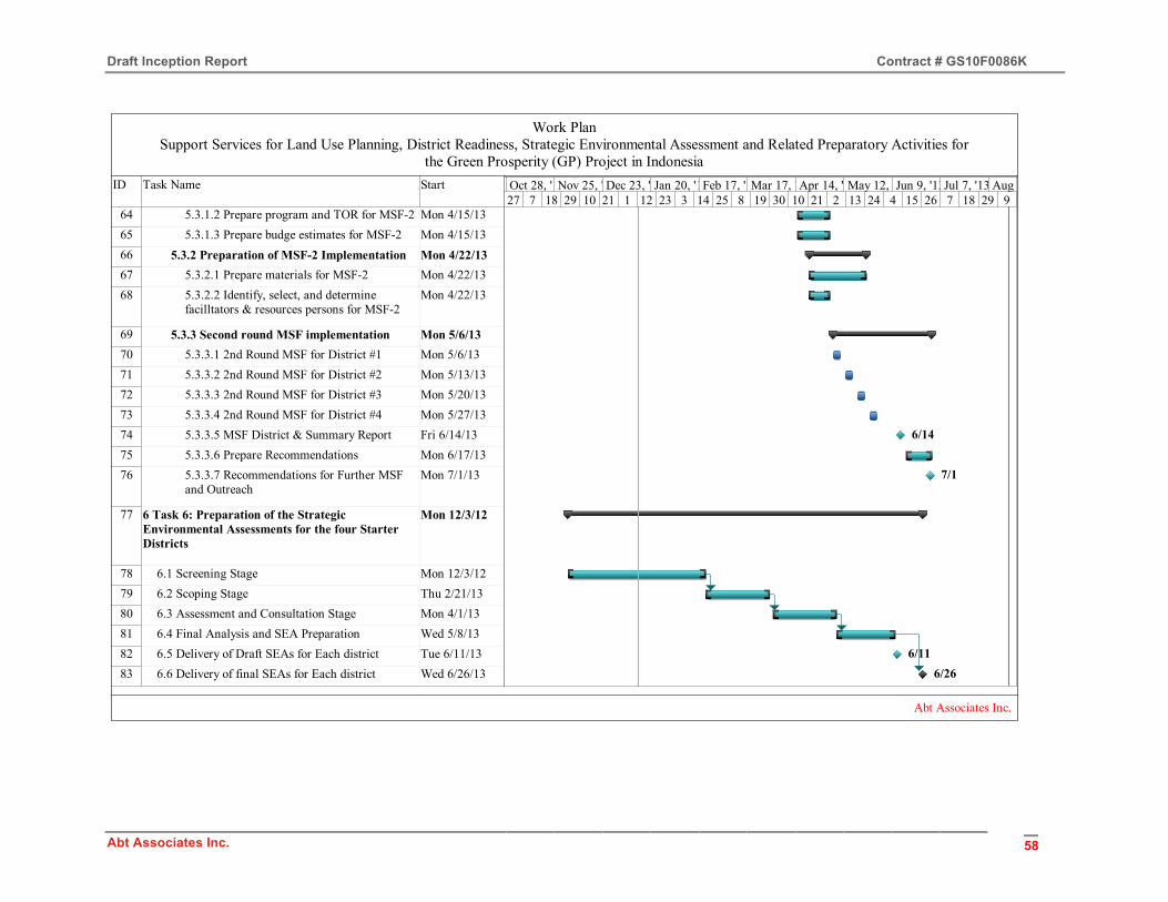
Draft Inception Report Contract # GS10F0086K
Abt Associates Inc. 58
ID Task Name Start
64 5.3.1.2 Prepare program and TOR for MSF-2 Mon 4/15/1365 5.3.1.3 Prepare budge estimates for MSF-2 Mon 4/15/1366 5.3.2 Preparation of MSF-2 Implementation Mon 4/22/1367 5.3.2.1 Prepare materials for MSF-2 Mon 4/22/1368 5.3.2.2 Identify, select, and determine
facilltators & resources persons for MSF-2Mon 4/22/13
69 5.3.3 Second round MSF implementation Mon 5/6/1370 5.3.3.1 2nd Round MSF for District #1 Mon 5/6/1371 5.3.3.2 2nd Round MSF for District #2 Mon 5/13/1372 5.3.3.3 2nd Round MSF for District #3 Mon 5/20/1373 5.3.3.4 2nd Round MSF for District #4 Mon 5/27/1374 5.3.3.5 MSF District & Summary Report Fri 6/14/1375 5.3.3.6 Prepare Recommendations Mon 6/17/1376 5.3.3.7 Recommendations for Further MSF
and OutreachMon 7/1/13
77 6 Task 6: Preparation of the Strategic Environmental Assessments for the four Starter Districts
Mon 12/3/12
78 6.1 Screening Stage Mon 12/3/1279 6.2 Scoping Stage Thu 2/21/1380 6.3 Assessment and Consultation Stage Mon 4/1/1381 6.4 Final Analysis and SEA Preparation Wed 5/8/1382 6.5 Delivery of Draft SEAs for Each district Tue 6/11/1383 6.6 Delivery of final SEAs for Each district Wed 6/26/13
6/14
7/1
6/116/26
27 7 18 29 10 21 1 12 23 3 14 25 8 19 30 10 21 2 13 24 4 15 26 7 18 29 9Sep 30, '12Oct 28, '12Nov 25, '12Dec 23, '12Jan 20, '13Feb 17, '13Mar 17, '13Apr 14, '13May 12, '13Jun 9, '13Jul 7, '13 Aug 4, '13
Work PlanSupport Services for Land Use Planning, District Readiness, Strategic Environmental Assessment and Related Preparatory Activities for
the Green Prosperity (GP) Project in Indonesia
Abt Associates Inc.

Draft Inception Report Contract # GS10F0086K
Abt Associates Inc. 59
ID Task Name Start
84 7 Task 7: Recomendantions for GP Rollout and Implementation
Fri 6/7/13
85 7.1 <New Task>86 7.2 Cataloging of Information Fri 6/7/1387 7.3 Preparation of the Final Draft Report Fri 6/21/1388 7.4 Submission of the Draft Final Report Thu 7/18/1389 7.5 Revision of the Report by MCC Fri 7/19/1390 7.6 Incorporation of Comments to the Final Report Fri 8/2/1391 7.7 Delivery of Final Report Thu 8/15/1392 8 Task 8: Optional Green Knowledge Concept
PaperMon 4/22/13
93 8.1 Preparation of the Concept Paper Mon 4/22/1394 8.2 Delivery of the Concept Paper Mon 7/15/13
7/18
7/15
27 7 18 29 10 21 1 12 23 3 14 25 8 19 30 10 21 2 13 24 4 15 26 7 18 29 9Sep 30, '12Oct 28, '12Nov 25, '12Dec 23, '12Jan 20, '13Feb 17, '13Mar 17, '13Apr 14, '13May 12, '13Jun 9, '13Jul 7, '13 Aug 4, '13
Work PlanSupport Services for Land Use Planning, District Readiness, Strategic Environmental Assessment and Related Preparatory Activities for
the Green Prosperity (GP) Project in Indonesia
Abt Associates Inc.
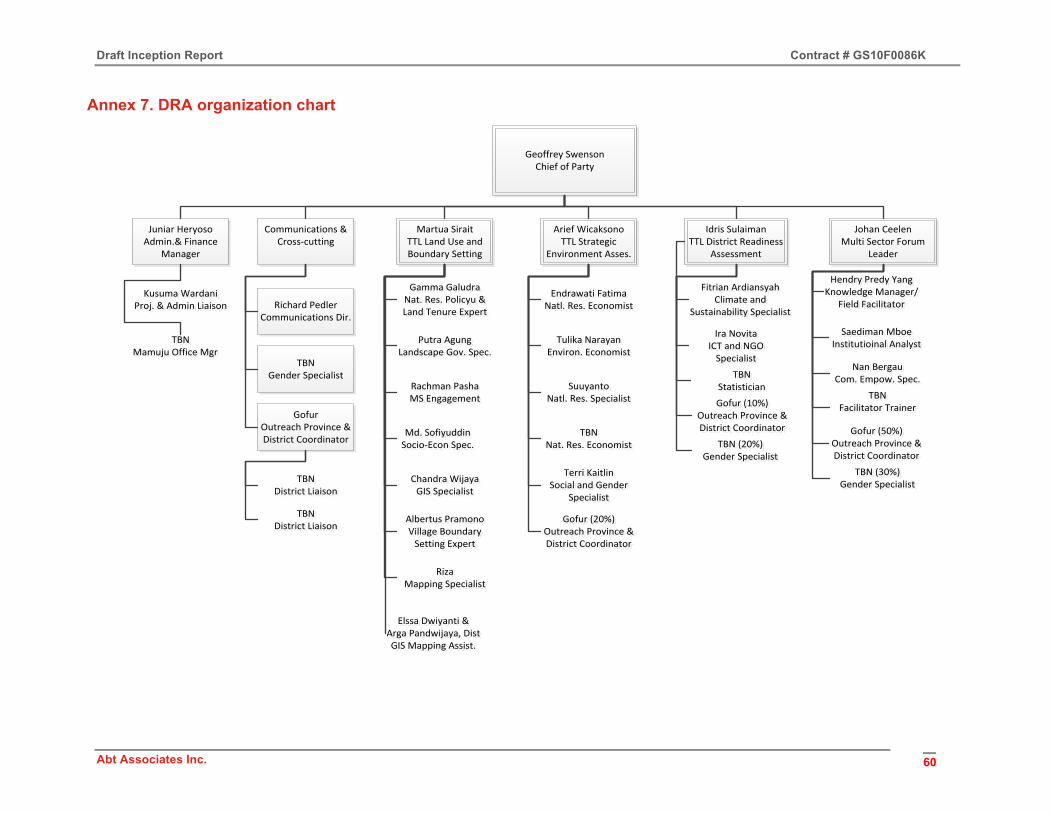
Draft Inception Report Contract # GS10F0086K
Abt Associates Inc. 60
Annex 7. DRA organization chart
Geoffrey SwensonChief of Party
Arief WicaksonoTTL Strategic
Environment Asses.
Idris SulaimanTTL District Readiness
Assessment
Martua SiraitTTL Land Use and Boundary Setting
Juniar HeryosoAdmin.& Finance
Manager
Gamma GaludraNat. Res. Policyu & Land Tenure Expert
Gamma GaludraNat. Res. Policyu & Land Tenure Expert
Putra Agung Landscape Gov. Spec.
Putra Agung Landscape Gov. Spec.
Rachman PashaMS EngagementRachman PashaMS Engagement
Md. SofiyuddinSocio-‐Econ Spec.Md. SofiyuddinSocio-‐Econ Spec.
Chandra WijayaGIS Specialist
Chandra WijayaGIS Specialist
Albertus PramonoVillage Boundary Setting Expert
Albertus PramonoVillage Boundary Setting Expert
RizaMapping Specialist
RizaMapping Specialist
Endrawati FatimaNatl. Res. EconomistEndrawati Fatima
Natl. Res. Economist
Tulika NarayanEnviron. EconomistTulika Narayan
Environ. Economist
SuuyantoNatl. Res. Specialist
SuuyantoNatl. Res. Specialist
Kusuma WardaniProj. & Admin LiaisonKusuma Wardani
Proj. & Admin Liaison
Elssa Dwiyanti & Arga Pandwijaya, DistGIS Mapping Assist.
Elssa Dwiyanti & Arga Pandwijaya, DistGIS Mapping Assist.
Johan CeelenMulti Sector Forum
Leader
TBNMamuju Office Mgr
TBNMamuju Office Mgr
Fitrian ArdiansyahClimate and
Sustainability Specialist
Fitrian ArdiansyahClimate and
Sustainability Specialist
Ira NovitaICT and NGO Specialist
Ira NovitaICT and NGO Specialist
Hendry Predy YangKnowledge Manager/
Field Facilitator
Hendry Predy YangKnowledge Manager/
Field Facilitator
Saediman MboeInstitutioinal AnalystSaediman Mboe
Institutioinal Analyst
TBNNat. Res. Economist
TBNNat. Res. Economist
Terri KaitlinSocial and Gender
Specialist
Terri KaitlinSocial and Gender
Specialist
Communications & Cross-‐cutting
Richard PedlerCommunications Dir.
TBNGender Specialist
GofurOutreach Province &District Coordinator
TBNDistrict Liaison
TBNDistrict Liaison
TBNDistrict Liaison
TBNDistrict Liaison
Nan BergauCom. Empow. Spec.
Nan BergauCom. Empow. Spec.
TBNFacilitator Trainer
TBNFacilitator Trainer
TBNStatistician
TBNStatistician
Gofur (10%)Outreach Province & District Coordinator
Gofur (10%)Outreach Province & District Coordinator Gofur (50%)
Outreach Province & District Coordinator
Gofur (50%)Outreach Province & District Coordinator
Gofur (20%)Outreach Province & District Coordinator
Gofur (20%)Outreach Province & District Coordinator
TBN (20%)Gender Specialist
TBN (20%)Gender Specialist
TBN (30%)Gender Specialist
TBN (30%)Gender Specialist
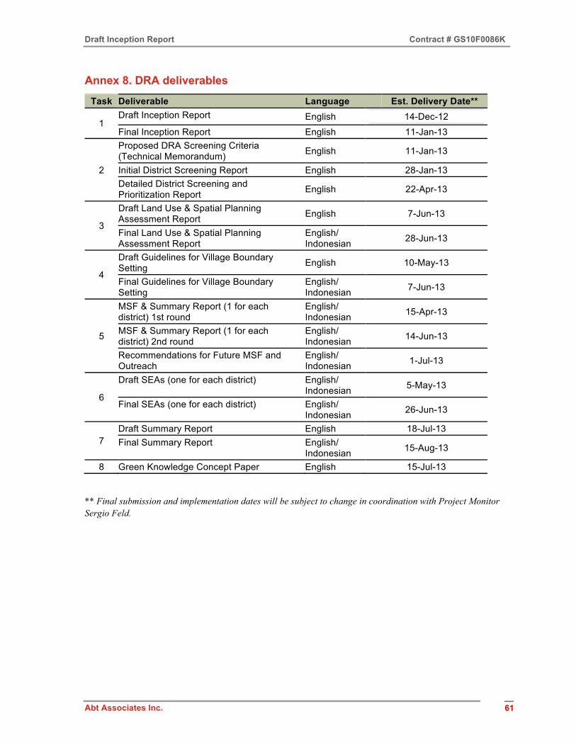
Draft Inception Report Contract # GS10F0086K
Abt Associates Inc. 61 61
Annex 8. DRA deliverables
Task Deliverable Language Est. Delivery Date**
1 Draft Inception Report English 14-Dec-12 Final Inception Report English 11-Jan-13
2
Proposed DRA Screening Criteria (Technical Memorandum) English 11-Jan-13
Initial District Screening Report English 28-Jan-13 Detailed District Screening and Prioritization Report English 22-Apr-13
3
Draft Land Use & Spatial Planning Assessment Report English 7-Jun-13
Final Land Use & Spatial Planning Assessment Report
English/ Indonesian 28-Jun-13
4
Draft Guidelines for Village Boundary Setting English 10-May-13
Final Guidelines for Village Boundary Setting
English/ Indonesian 7-Jun-13
5
MSF & Summary Report (1 for each district) 1st round
English/ Indonesian 15-Apr-13
MSF & Summary Report (1 for each district) 2nd round
English/ Indonesian 14-Jun-13
Recommendations for Future MSF and Outreach
English/ Indonesian 1-Jul-13
6
Draft SEAs (one for each district) English/ Indonesian 5-May-13
Final SEAs (one for each district) English/ Indonesian 26-Jun-13
7 Draft Summary Report English 18-Jul-13 Final Summary Report English/
Indonesian 15-Aug-13
8 Green Knowledge Concept Paper English 15-Jul-13
** Final submission and implementation dates will be subject to change in coordination with Project Monitor Sergio Feld.