imagine holgate: transit-oriented community vision plan
TRANSCRIPT
TRANSIT-ORIENTED COMMUNITY VISION PLAN
HOLGATE

3
INTENTIONALLY BLANK
3
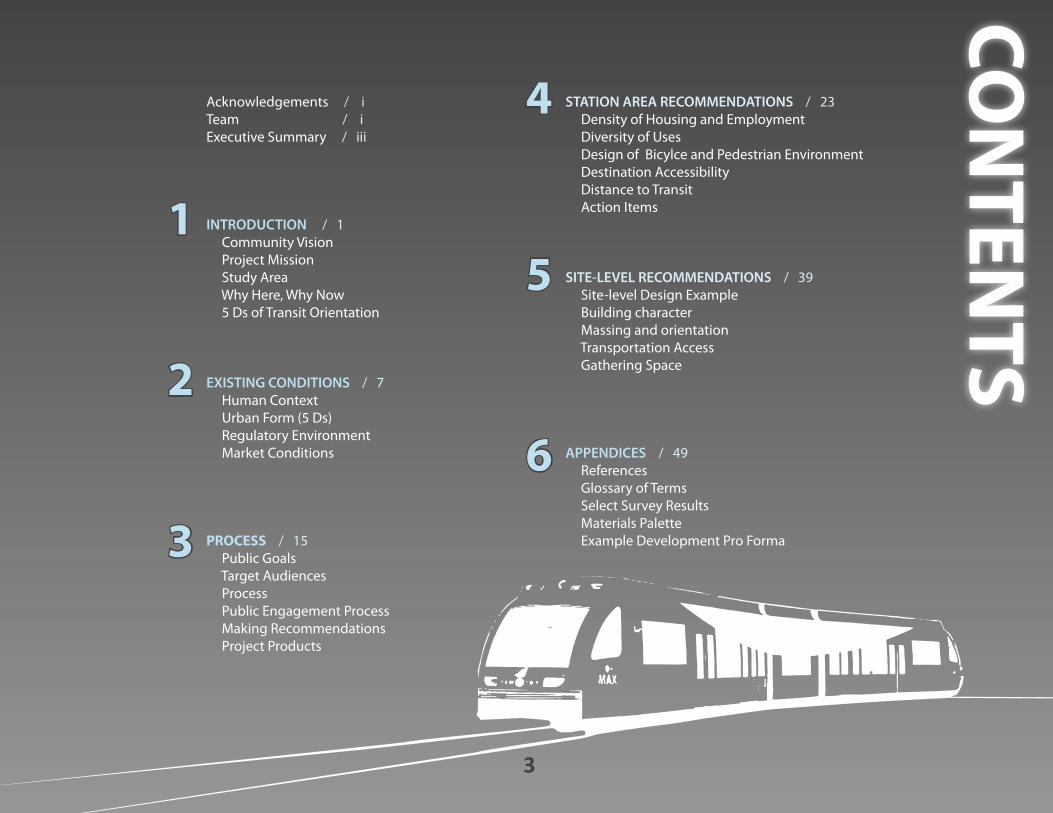
Acknowledgements / iTeam / i Executive Summary / iii
INTRODUCTION / 1 Community Vision Project Mission Study Area Why Here, Why Now 5 Ds of Transit Orientation
EXISTING CONDITIONS / 7 Human Context Urban Form (5 Ds) Regulatory Environment Market Conditions
PROCESS / 15 Public Goals Target Audiences Process Public Engagement Process Making Recommendations Project Products
CON
TENTS
1
STATION AREA RECOMMENDATIONS / 23 Density of Housing and Employment Diversity of Uses Design of Bicylce and Pedestrian Environment Destination Accessibility Distance to Transit Action Items
SITE-LEVEL RECOMMENDATIONS / 39 Site-level Design Example Building character Massing and orientation Transportation Access Gathering Space
APPENDICES / 49 References Glossary of Terms Select Survey Results Materials Palette Example Development Pro Forma
6
4
2
3
5
i TRANSIT-ORIENTED COMMUNITY VISION PLAN
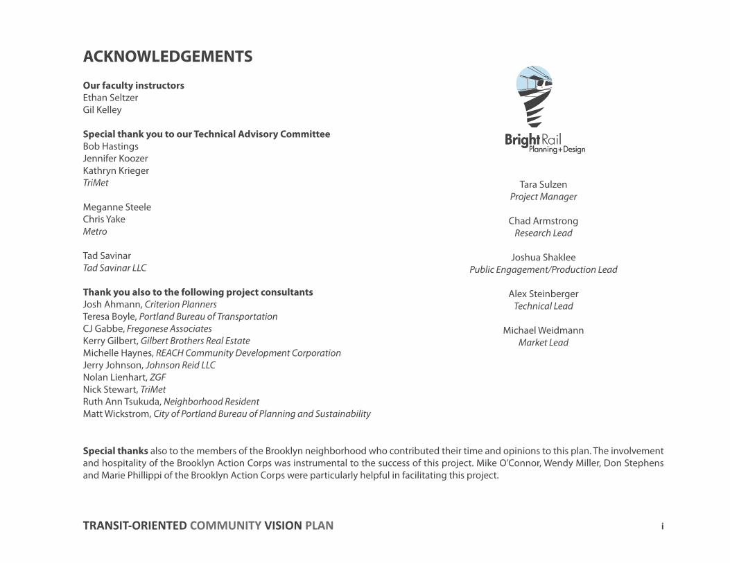
ACKNOWLEDGEMENTS
Our faculty instructorsEthan SeltzerGil Kelley
Special thank you to our Technical Advisory CommitteeBob HastingsJennifer KoozerKathryn KriegerTriMet
Meganne SteeleChris Yake Metro
Tad SavinarTad Savinar LLC
Thank you also to the following project consultantsJosh Ahmann, Criterion Planners Teresa Boyle, Portland Bureau of TransportationCJ Gabbe, Fregonese AssociatesKerry Gilbert, Gilbert Brothers Real Estate Michelle Haynes, REACH Community Development CorporationJerry Johnson, Johnson Reid LLC Nolan Lienhart, ZGF Nick Stewart, TriMetRuth Ann Tsukuda, Neighborhood ResidentMatt Wickstrom, City of Portland Bureau of Planning and Sustainability
Tara SulzenProject Manager
Chad ArmstrongResearch Lead
Joshua Shaklee Public Engagement/Production Lead
Alex Steinberger Technical Lead
Michael WeidmannMarket Lead
Special thanks also to the members of the Brooklyn neighborhood who contributed their time and opinions to this plan. The involvement and hospitality of the Brooklyn Action Corps was instrumental to the success of this project. Mike O’Connor, Wendy Miller, Don Stephens and Marie Phillippi of the Brooklyn Action Corps were particularly helpful in facilitating this project.
ii IMAGINE HOLGATE
EXECUTIVE SUMMARYEXECUTIVE SUMMARYThe Portland-Milwaukie Light Rail (PMLR) line will open in 2015 and bring change to the Brooklyn neighborhood of Portland, Oregon. The Imagine Holgate project engaged the public in a visioning process to learn the community aspirations for future transit-oriented development in the Station Area around the southeast 17th Avenue and Holgate Boulevard Station on the PMLR line.
Imagine Holgate was initiated by TriMet and Metro, and completed as a Portland State University Workshop project by BrightRail Planning + Design, a group of five students in the Masters of Urban and Regional Planning program. The four-month study included significant public engagement, research, analysis and regular presentations of findings.
This Transit-Oriented Community Vision Plan provides an overview of existing conditions in the Station Area, including a brief history of the Brooklyn neighborhood, a snapshot of Station Area demographics and the regulatory environment and market conditions for development in the area. It also prescribes actionable recommendations to reconnect an area of Portland that historically depended on commuter railfor its livelihood.
Project Findings
Findings of the Imagine Holgate project include:
• Zoning changes to promote a broader range of commercial and employment uses will enhance community vitality.
• There is a specific and identified need for more neighborhood destinations, places to eat, drink and shop, and there are a variety of parcels prime for redevelopment or new development.
• Investments in biking and pedestrian infrastructure will significantly improve the safety and connectivity of the Station Area.
• Station Area residents value the area’s historic buildings, industrial character and family-friendly atmosphere. New development
should reflect those priorities.
• There is a strong base of density in the existing neighborhood, and significant opportunities for new growth to activate the Station Area.
This Transit-Oriented Community Vision Plan synthesizes these aspirations into a set of recommendations for development in the SE 17th/Holgate Station Area. Recommendations are organized by the scale at which they should be considered: Station Area recommendations identify measures that can be implemented on a large scale within a quarter mile of the light rail station and site-level recommendations identify actions that can take place at the level of an individual property, including recommendations for building character, massing and orientation, transportation access and gathering space.
iii TRANSIT-ORIENTED COMMUNITY VISION PLAN
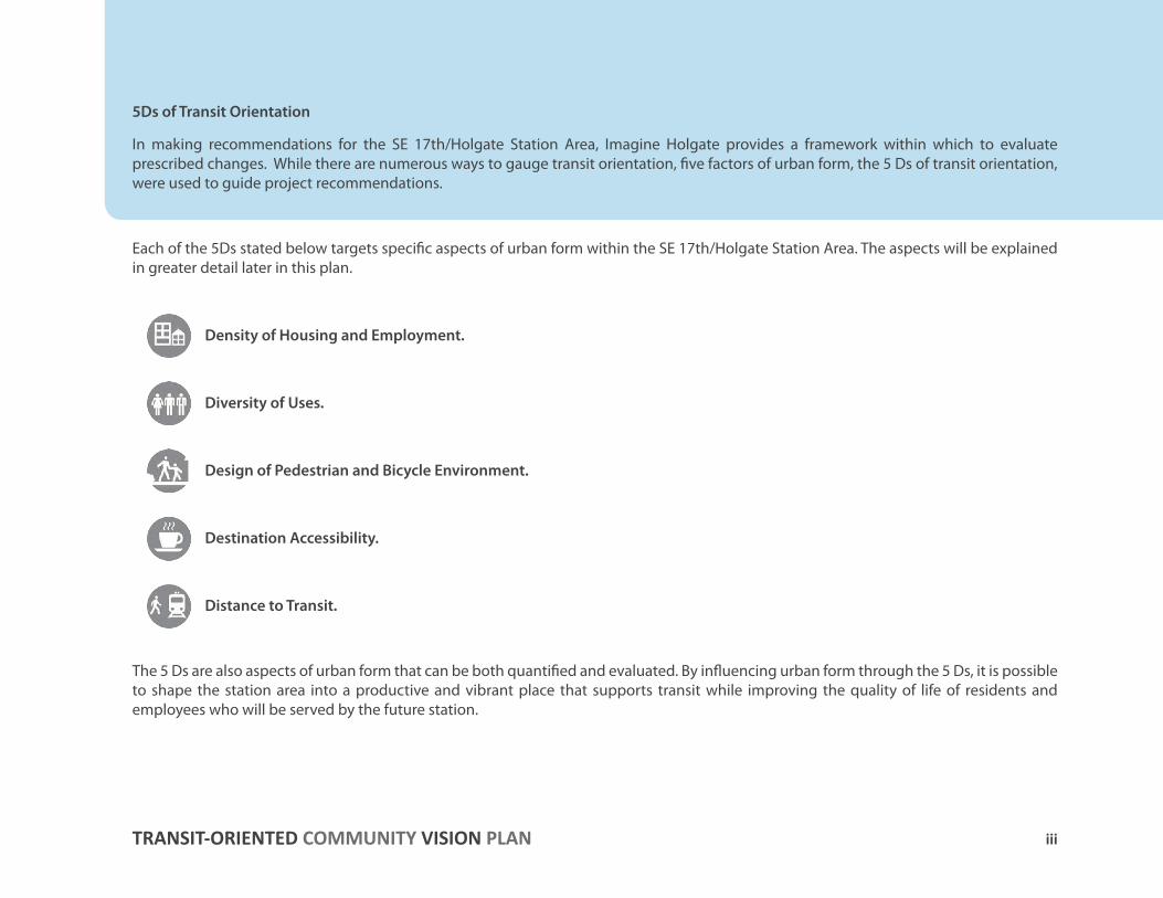
5Ds of Transit Orientation
In making recommendations for the SE 17th/Holgate Station Area, Imagine Holgate provides a framework within which to evaluate prescribed changes. While there are numerous ways to gauge transit orientation, five factors of urban form, the 5 Ds of transit orientation, were used to guide project recommendations.
Each of the 5Ds stated below targets specific aspects of urban form within the SE 17th/Holgate Station Area. The aspects will be explained in greater detail later in this plan.
Density of Housing and Employment.
Diversity of Uses.
Design of Pedestrian and Bicycle Environment.
Destination Accessibility.
Distance to Transit.
The 5 Ds are also aspects of urban form that can be both quantified and evaluated. By influencing urban form through the 5 Ds, it is possible to shape the station area into a productive and vibrant place that supports transit while improving the quality of life of residents and employees who will be served by the future station.
1
Community VisionProject Mission
Study AreaWhy Here, Why Now
5 Ds of Transit Orientation
INTRO
DU
CTION
1
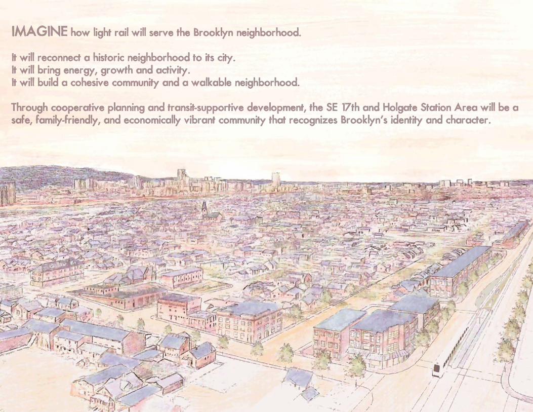
IMAGINE how light rail will serve the Brooklyn neighborhood.
It will reconnect a historic neighborhood to its city.It will bring energy, growth and activity.It will build a cohesive community and a walkable neighborhood.
Through cooperative planning and transit-supportive development, the SE 17th and Holgate Station Area will be a safe, family-friendly, and economically vibrant community that recognizes Brooklyn’s identity and character.
IMAGINE how light rail will serve the Brooklyn neighborhood.
It will reconnect a historic neighborhood to its city.It will bring energy, growth and activity.It will build a cohesive community and a walkable neighborhood.
Through cooperative planning and transit-supportive development, the SE 17th and Holgate Station Area will be a safe, family-friendly, and economically vibrant community that recognizes Brooklyn’s identity and character. IMAGINE
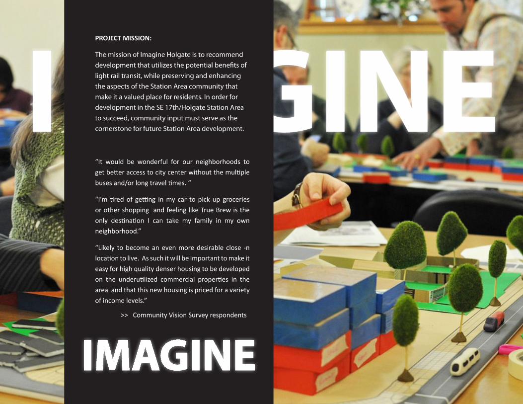
PROJECT MISSION:
The mission of Imagine Holgate is to recommend development that utilizes the potential benefits of light rail transit, while preserving and enhancing the aspects of the Station Area community that make it a valued place for residents. In order for development in the SE 17th/Holgate Station Area to succeed, community input must serve as the cornerstone for future Station Area development.
“It would be wonderful for our neighborhoods to get better access to city center without the multiple buses and/or long travel times. “
“I’m tired of getting in my car to pick up groceries or other shopping and feeling like True Brew is the only destination I can take my family in my own neighborhood.”
“Likely to become an even more desirable close -n location to live. As such it will be important to make it easy for high quality denser housing to be developed on the underutilized commercial properties in the area and that this new housing is priced for a variety of income levels.”
>> Community Vision Survey respondents
IMAGINE
I -205
Willamette River
I-5
I-84
Columbia River
4 Introduction >> IMAGINE HOLGATE
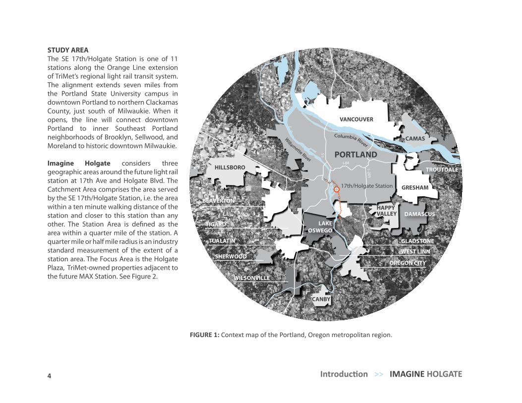
FIGURE 1: Context map of the Portland, Oregon metropolitan region.
STUDY AREAThe SE 17th/Holgate Station is one of 11 stations along the Orange Line extension of TriMet’s regional light rail transit system. The alignment extends seven miles from the Portland State University campus in downtown Portland to northern Clackamas County, just south of Milwaukie. When it opens, the line will connect downtown Portland to inner Southeast Portland neighborhoods of Brooklyn, Sellwood, and Moreland to historic downtown Milwaukie.
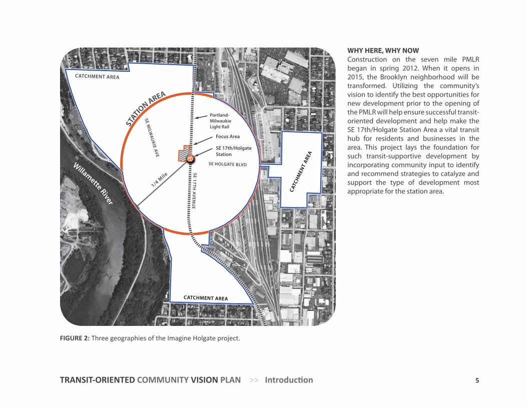
Imagine Holgate considers three geographic areas around the future light rail station at 17th Ave and Holgate Blvd. The Catchment Area comprises the area served by the SE 17th/Holgate Station, i.e. the area within a ten minute walking distance of the station and closer to this station than any other. The Station Area is defined as the area within a quarter mile of the station. A quarter mile or half mile radius is an industry standard measurement of the extent of a station area. The Focus Area is the Holgate Plaza, TriMet-owned properties adjacent to the future MAX Station. See Figure 2.
PORTLAND
GRESHAM
VANCOUVER
OREGON CITY
BEAVERTON
HILLSBORO
TIGARD
TUALATIN
SHERWOOD
WILSONVILLE
LAKE OSWEGO
GLADSTONE
WEST LINN
17th/Holgate Station
CAMAS
DAMASCUS
TROUTDALE
HAPPYVALLEY
CANBY
5 TRANSIT-ORIENTED COMMUNITY VISION PLAN >> Introduction
WHY HERE, WHY NOWConstruction on the seven mile PMLR began in spring 2012. When it opens in 2015, the Brooklyn neighborhood will be transformed. Utilizing the community’s vision to identify the best opportunities for new development prior to the opening of the PMLR will help ensure successful transit-oriented development and help make the SE 17th/Holgate Station Area a vital transit hub for residents and businesses in the area. This project lays the foundation for such transit-supportive development by incorporating community input to identify and recommend strategies to catalyze and support the type of development most appropriate for the station area.
FIGURE 2: Three geographies of the Imagine Holgate project.
STATIO
N AREA
Willamette River
Portland-MilwaukieLight Rail
Focus Area
SE 17th/Holgate Station
CATCHMENT AREA
SE HOLGATE BLVD
CATC
HM
ENT
ARE
A
CATCHMENT AREA
SE 17TH A
VEN
UE
SE MILW
AU
KIE A
VE
1/4 M
ile
7 6 Introduction >> IMAGINE HOLGATE
5 Ds OF TRANSIT ORIENTATION
High-capacity transit investments have the potential to revitalize neighborhoods and restore historic connections. In the SE 17th/Holgate Station Area, there are opportunities to leverage light rail investment to benefit the Brooklyn community. Moreover, the success of the PMLR line is dependent on its ability to build transit ridership near its eleven future stations. In making recommendations for the SE 17th/Holgate station area, Imagine Holgate aims to maximize the benefits that light rail can provide, by improving the way that urban form re-sponds to transit.
While there are numerous ways to evaluate the transit orientation of a neighborhood, Imagine Holgate used 5 factors of urban form, the 5 Ds of transit orientation, to gauge existing conditions and guide project recommendations. Each of the 5Ds, stated below, targets specific aspects of urban form within the SE 17th/Holgate Station Area.
Density of Housing and Employment: Increase activity in the station area to support safety and the viability of new retail busi-nesses by increasing the number of residential and employment-supportive uses per acre.
Diversity of Uses: Promoting a diverse mix of residential, retail, and employment uses reduces the need for trips outside the station area.
Design of Pedestrian and Bicycle Environment: Increase activity and circulation within the station area by creating a more convenient, safe, and engaging environment for pedestrians and cyclists.
Destination Accessibility: Reduce the need for automobile trips and stimulate commercial activity within the station area by promoting more retail amenities and neighborhood destinations.
Distance to Transit: Broaden the impact of transit investments by improving mulit-modal connectivity and ease of access to transit.
The 5 Ds provide a framework with which to guide development in the SE 17th/Holgate Station Area. More importantly, they are aspects of urban form that can be both quantified and evaluated. By influencing urban form through the 5 Ds, it is possible to shape the station area into a productive and vibrant place that supports transit while improving the quality of life of residents and employees who live and work around the future station.
7
EXISTING
CO
ND
ITION
S Human Context A History of Brooklyn Context for Planning DemographicsUrban Form (5 Ds)Regulatory EnvironmentMarket Conditions
2
8 Existing Conditions >> IMAGINE HOLGATE
HUMAN CONTEXT
A History of Brooklyn. The area now known as the Brooklyn neighborhood was subdivided from its original land claim in 1868 to provide housing for Portland’s expanding population. Many early residents were workers at the nearby Inman-Poulsen Lumber Mill and the Southern Pacific Rail Yards. Since that time, however, the neighborhood has undergone many significant changes. The mill, once the economic lifeblood of the community, closed in 1954. In the past, most of Brooklyn’s workforce was employed by industries like timber, railroad, and mining. By 2000, the share of Brooklyn residents employed by those industries was just one in four. A streetcar line that once connected neighborhood residents to jobs and amenities in downtown
Portland was decommissioned in 1950. The construction of major transportation routes and industrial areas on all sides of Brooklyn has significantly diminished its geographic area over time. Yet despite these trends, the neighborhood remains resilient and active. The Brooklyn Action Corps (BAC) was organized in 1962 to give the neighborhood a political voice, and the neighborhood expanded in the late 1980s to include the area south of Holgate Boulevard and northeast of McLoughlin. The Portland Milwaukie Light Rail (PMLR), will bring new access to a broader range of employment for Brooklyn’s workforce via fast, safe and affordable transportation to downtown Portland and beyond.
Context for Planning. Metro’s 2040 Growth Concept and map identifies McLoughlin Blvd as a mixed-use corridor and Milwaukie Ave as a Main Street, which under Metro’s definition “have a traditional commercial identity but are on a smaller scale with a strong sense of the immediate neighborhood”. The PMLR is prioritized as a mobility corridor in Metro’s 2035 Regional Transportation Plan to encourage growth between downtown Portland and downtown Milwaukie, Oregon, a town center in the 2040 Growth Concept. Metro also created a Regional High Capacity Transit System Plan which considers ways to catalyze development along transit lines.
The 1991 Brooklyn Neighborhood Plan, created by residents and the City of Portland, proposed strategies to improve the neighborhood. It expressed a desire that Milwaukie Ave become a more vibrant, attractive mixed commercial core where residents can live, work, shop and socialize.
The vision of the community at that time was “to preserve the character and diversity of the Brooklyn neighborhood with safe streets, cherished homes, comfortable gathering places and a healthy balance between businesses and residences”. The plan also considered the reintroduction of light rail service to Brooklyn. The process of updating the 1980 Portland Comprehensive Plan begins in 2012 and will provide opportunities to update zoning and policy that can facilitate transit-oriented development in Brooklyn.
Milwaukie Ave in Brooklyn was the subject of a Portland State University Masters of Urban and Regional Planning workshop project in 2006. Five students worked with the BAC to create the Milwaukie Avenue Main Street Plan, a study of improvements to Milwaukie Avenue to make it a more viable commercial corridor.
Demographics. The population of the Catchment Area is largely white, a reflection of Brooklyn’s history as home to mill and rail workers of Italian, Polish
EXISTING CONDITIONS
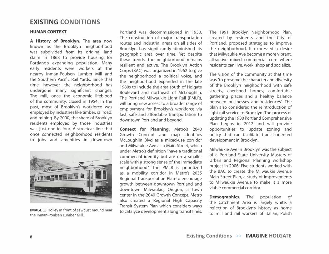
IMAGE 1. Trolley in front of sawdust mound near the Inman-Poulsen Lumber Mill.
9 TRANSIT-ORIENTED COMMUNITY VISION PLAN >> Existing Conditions
and German descent. Research indicates the neighborhood is experiencing several trends. Data shows that Brooklyn’s population is aging. School aged children are projected to drop as a share of Catchment Area population by 2015, however, this is disputed by community members. Further research is required to confirm this.
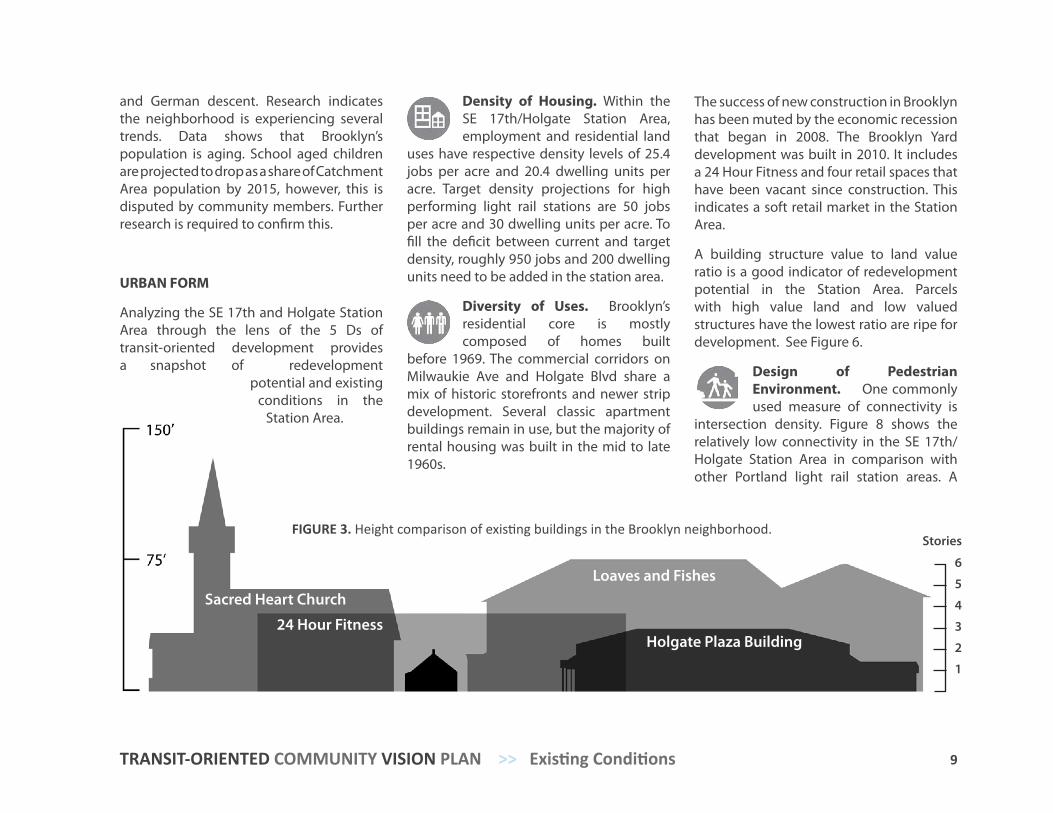
URBAN FORM
Analyzing the SE 17th and Holgate Station Area through the lens of the 5 Ds of transit-oriented development provides a snapshot of redevelopment
potential and existing conditions in the
Station Area.
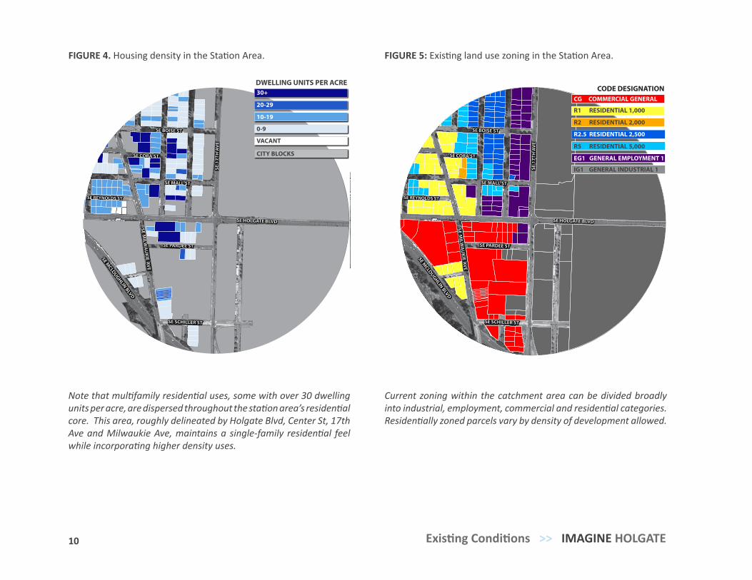
Density of Housing. Within the SE 17th/Holgate Station Area, employment and residential land
uses have respective density levels of 25.4 jobs per acre and 20.4 dwelling units per acre. Target density projections for high performing light rail stations are 50 jobs per acre and 30 dwelling units per acre. To fill the deficit between current and target density, roughly 950 jobs and 200 dwelling units need to be added in the station area.
Diversity of Uses. Brooklyn’s residential core is mostly composed of homes built
before 1969. The commercial corridors on Milwaukie Ave and Holgate Blvd share a mix of historic storefronts and newer strip development. Several classic apartment buildings remain in use, but the majority of rental housing was built in the mid to late 1960s.
The success of new construction in Brooklyn has been muted by the economic recession that began in 2008. The Brooklyn Yard development was built in 2010. It includes a 24 Hour Fitness and four retail spaces that have been vacant since construction. This indicates a soft retail market in the Station Area.
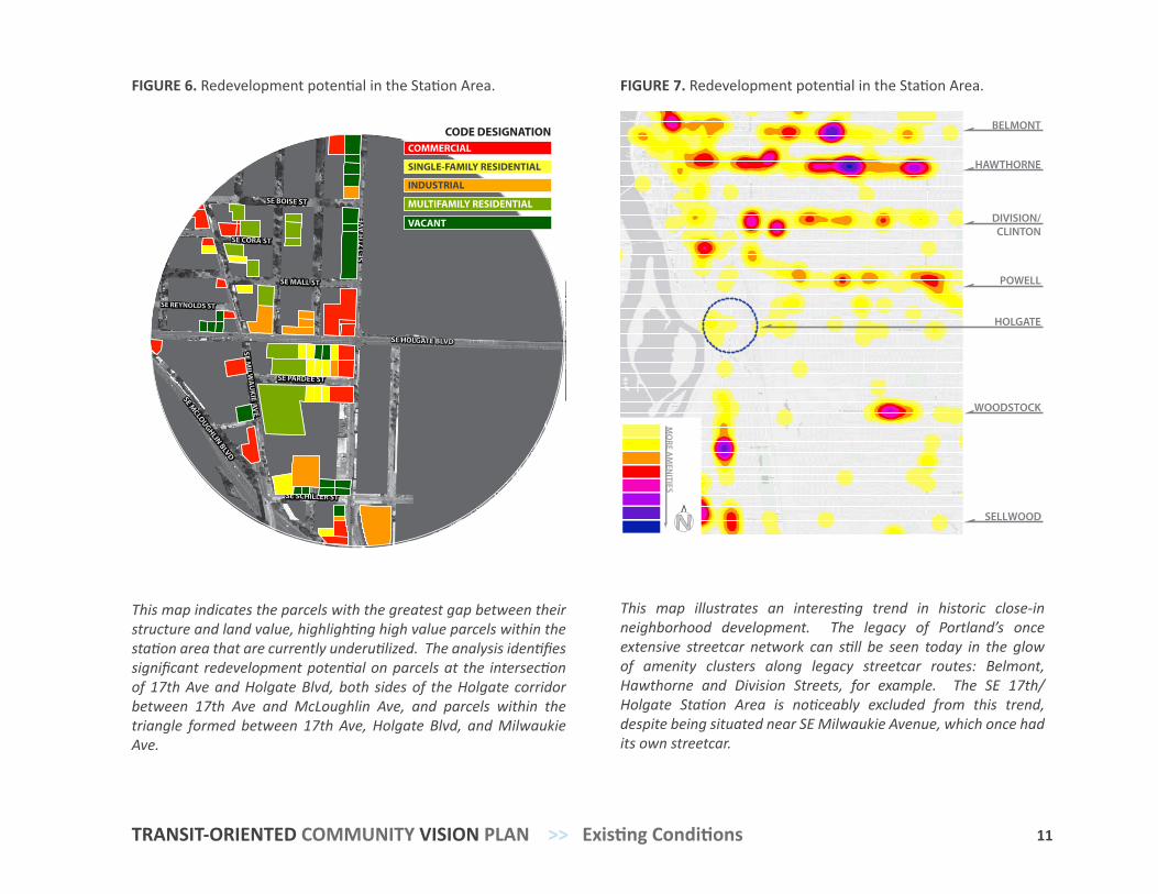
A building structure value to land value ratio is a good indicator of redevelopment potential in the Station Area. Parcels with high value land and low valued structures have the lowest ratio are ripe for development. See Figure 6.
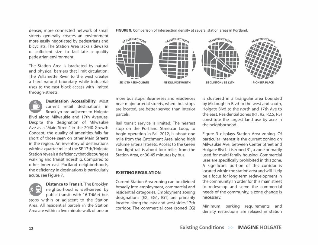
Design of Pedestrian Environment. One commonly used measure of connectivity is
intersection density. Figure 8 shows the relatively low connectivity in the SE 17th/Holgate Station Area in comparison with other Portland light rail station areas. A
FIGURE 3. Height comparison of existing buildings in the Brooklyn neighborhood.
Sacred Heart Church
24 Hour Fitness
Loaves and Fishes
Holgate Plaza Building
6
5
4
3
2
1
Stories
SE CORA ST
SE BOISE ST
SE MALL ST
SE REYNOLDS ST
SE HOLGATE BLVD
SE PARDEE ST
SE SCHILLER ST
SE MCLOUGHLIN BLVD
SE MILW
AU
KIE AVE
SE 1
7TH
AV
E
DWELLING UNITS PER ACRE
10-19
20-29
30+
0-9
VACANT
CITY BLOCKS SE CORA ST
SE BOISE ST
SE MALL ST
SE REYNOLDS ST
SE HOLGATE BLVD
SE PARDEE ST
SE SCHILLER ST
SE MCLOUGHLIN BLVD
SE MILW
AU
KIE AVE
SE 1
7TH
AV
E
CODE DESIGNATIONCG COMMERCIAL GENERAL
R5 RESIDENTIAL 5,000
IG1 GENERAL INDUSTRIAL 1
EG1 GENERAL EMPLOYMENT 1
R2 RESIDENTIAL 2,000
R1 RESIDENTIAL 1,000
R2.5 RESIDENTIAL 2,500
10 Existing Conditions >> IMAGINE HOLGATE
FIGURE 4. Housing density in the Station Area. FIGURE 5: Existing land use zoning in the Station Area.
Current zoning within the catchment area can be divided broadly into industrial, employment, commercial and residential categories. Residentially zoned parcels vary by density of development allowed.
Note that multifamily residential uses, some with over 30 dwelling units per acre, are dispersed throughout the station area’s residential core. This area, roughly delineated by Holgate Blvd, Center St, 17th Ave and Milwaukie Ave, maintains a single-family residential feel while incorporating higher density uses.
SE CORA ST
SE BOISE ST
SE MALL ST
SE REYNOLDS ST
SE HOLGATE BLVD
SE PARDEE ST
SE SCHILLER ST
SE MCLOUGHLIN BLVD
SE MILW
AU
KIE AVE
SE 1
7TH
AV
E
CODE DESIGNATIONCOMMERCIAL
VACANT
INDUSTRIAL
SINGLE-FAMILY RESIDENTIAL
MULTIFAMILY RESIDENTIAL
POWELL
DIVISION/CLINTON
HAWTHORNE
BELMONT
HOLGATE
WOODSTOCK
SELLWOOD
MO
RE AM
ENITIES
N
11 TRANSIT-ORIENTED COMMUNITY VISION PLAN >> Existing Conditions
FIGURE 6. Redevelopment potential in the Station Area.
This map indicates the parcels with the greatest gap between their structure and land value, highlighting high value parcels within the station area that are currently underutilized. The analysis identifies significant redevelopment potential on parcels at the intersection of 17th Ave and Holgate Blvd, both sides of the Holgate corridor between 17th Ave and McLoughlin Ave, and parcels within the triangle formed between 17th Ave, Holgate Blvd, and Milwaukie Ave.
FIGURE 7. Redevelopment potential in the Station Area.
This map illustrates an interesting trend in historic close-in neighborhood development. The legacy of Portland’s once extensive streetcar network can still be seen today in the glow of amenity clusters along legacy streetcar routes: Belmont, Hawthorne and Division Streets, for example. The SE 17th/Holgate Station Area is noticeably excluded from this trend, despite being situated near SE Milwaukie Avenue, which once had its own streetcar.
12 Existing Conditions >> IMAGINE HOLGATE
denser, more connected network of small streets generally creates an environment more easily negotiated by pedestrians and bicyclists. The Station Area lacks sidewalks of sufficient size to facilitate a quality pedestrian environment.
The Station Area is bracketed by natural and physical barriers that limit circulation. The Willamette River to the west creates a hard natural boundary while industrial uses to the east block access with limited through-streets.
Destination Accessibility. Most current retail destinations in Brooklyn are adjacent to Holgate
Blvd along Milwaukie and 17th Avenues. Despite the designation of Milwaukie Ave as a “Main Street” in the 2040 Growth Concept, the quality of amenities falls far short of those seen on other Main Streets in the region. An inventory of destinations within a quarter mile of the SE 17th/Holgate Station reveals a deficiency that discourages walking and transit ridership. Compared to other inner east Portland neighborhoods, the deficiency in destinations is particularly acute, see Figure 7.
Distance to Transit. The Brooklyn neighborhood is well-served by public transit, with 16 TriMet bus
stops within or adjacent to the Station Area. All residential parcels in the Station Area are within a five minute walk of one or
more bus stops. Businesses and residences near major arterial streets, where bus stops are located, are better served than interior parcels.
Rail transit service is limited. The nearest stop on the Portland Streetcar Loop, to begin operation in Fall 2012, is about one mile from the Catchment Area, along high volume arterial streets. Access to the Green Line light rail is about four miles from the Station Area, or 30-45 minutes by bus.
EXISTING REGULATION
Current Station Area zoning can be divided broadly into employment, commercial and residential categories. Employment zoning designations (EX, EG1, IG1) are primarily located along the east and west sides 17th corridor. The commercial core (zoned CG)
is clustered in a triangular area bounded by McLoughlin Blvd to the west and south, Holgate Blvd to the north and 17th Ave to the east. Residential zones (R1, R2, R2.5, R5) constitute the largest land use by acre in the neighborhood.
Figure 3 displays Station Area zoning. Of particular interest is the current zoning on Milwaukie Ave, between Center Street and Holgate Blvd. It is zoned R1, a zone primarily used for multi-family housing. Commercial uses are specifically prohibited in this zone. A significant portion of this corridor is located within the station area and will likely be a focus for long term redevelopment in the community. In order for this main street to redevelop and serve the commercial needs of the community, a zone change is necessary.
Minimum parking requirements and density restrictions are relaxed in station
FIGURE 8. Comparison of intersection density at several station areas in Portland.
SE 17TH / SE HOLGATE NE KILLINGSWORTH SE CLINTON / SE 12TH PIONEER PLACE
47 INTERSECTIONS 68 INTERSECTIONS 85 INTERSECTIONS 90 INTERSECTIONS
13 TRANSIT-ORIENTED COMMUNITY VISION PLAN >> Existing Conditions
areas. Due to the frequent bus service along SE 17th there are currently no minimum parking requirements. Future Portland Comprehensive Plan updates will address development standards within the PMLR station areas more specifically. Current station area zoning designations allow various building height, setback, and floor area ratio requirements based on the distance from transit stops.
MARKET CONDITIONS
Real Estate markets are beginning to see some strong signs of recovery outside of the for sale housing markets, with multifamily and retail markets leading the way. The apartment sector is another bright spot in the overall housing market, with rising rents and low very low vacancies.
However, tight credit remains an issue. The National Association of Home Builders recently stated, “Capital is limited in this current market and developers are having a difficult time obtaining the credit needed to finance the development of new retail, apartment, and office construction. Credit restrictions are so tight that even developers with a strong balance sheet and reputation are having difficulty.”
According to the November 2011 National Association of Realtors report, Portland had a 2.80% vacancy rate, which is among the lowest vacancy rates in the US. Strong rental demand has persisted as fewer buyers are drawn to the single-market. The NAR report projects stronger performance in the multi-family market in 2012, 2013, and 2014 and forecasts that we are entering a “two to five year sweet spot in the market and real estate cycle”.
The majority of the multi-family product in Portland is Class B and C quality properties based on location and condition of the building. In Portland, approximately 70% of the apartments were built in the 1970s. These properties are often in the 8-60 unit range. As market conditions continue to improve these properties in the best locations will see increased interest from developers for redevelopment opportunities.
Based upon these market projections and impending light rail construction, development conditions in the Brooklyn neighborhood appear primed for new multifamily construction
and redevelopment of existing underperforming properties. Example financial pro formas for two potential infill development sites located on SE 17th Ave are included in Appendix E. The fact that total development costs exceed the projected capitalized value for both projects in these examples indicates this submarket currently lacks the market conditions to make new mid-rise infill development financially feasible without public subsidy. The lack of new development in the area makes accurate comparative market analysis difficult. In coming years as new projects develop and assessed values are established, developers will have more accurate comparables for financial analysis. Sites located prime locations, corners with good vehicular access, ground level retail opportunities, and within a few blocks of the SE 17th/Holgate Station present new opportunities for developers to pursue projects within this development cycle.
15
“I think TriMet and the City of Portland will do what they want regardless of how the residents feel. You can do all the surveys possible but I really doubt this will affect the bottom line which is revenue. If they can generate more revenue (rent/ property taxes/ property sales) in some way that is what will happen with the justification to come after the decision for land use. This is not an optimistic viewpoint but I think it’s a realistic one.”
“Diversity of construction style can be a strength, not a weakness, if the newer construction to come along is designed and built with quality. If we wanted to live in cookie-cutter neighborhoods where all the houses are the same style, we’d live in the suburbs.”
>> Community Vision Survey respondents
15
PROCESS
Process OverviewTarget AudiencesPublic Engagement ProcessMaking RecommendationsProject Products
3
16 Process >> IMAGINE HOLGATE
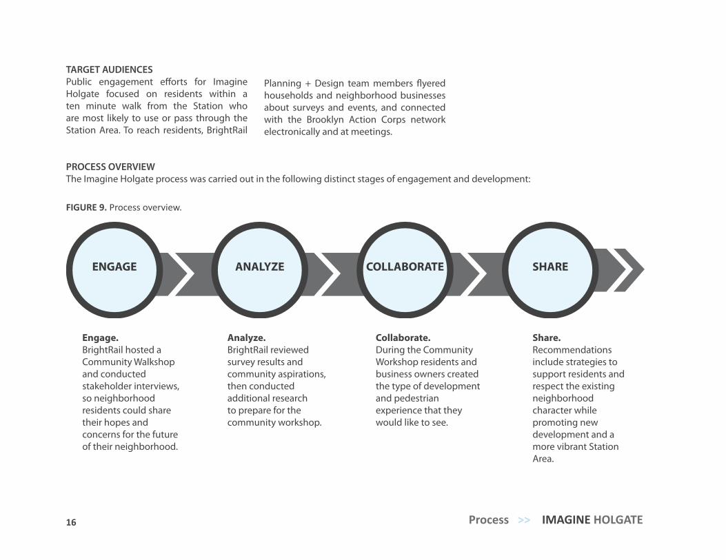
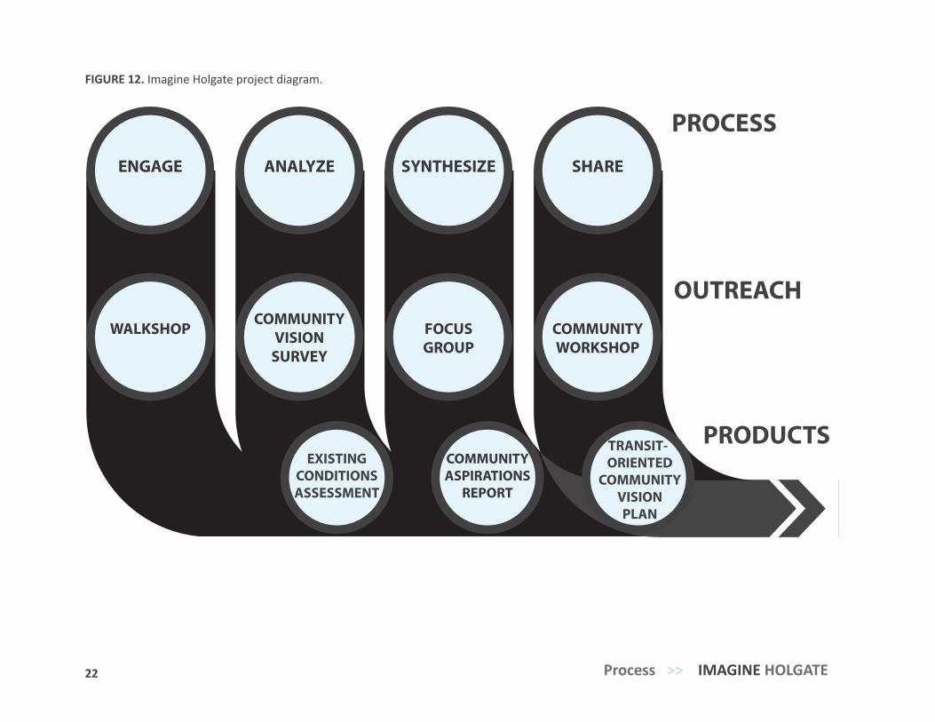
PROCESS OVERVIEWThe Imagine Holgate process was carried out in the following distinct stages of engagement and development:
Engage. BrightRail hosted a Community Walkshop and conducted stakeholder interviews, so neighborhood residents could share their hopes and concerns for the future of their neighborhood.
ENGAGE COLLABORATEANALYZE SHARE
Analyze. BrightRail reviewed survey results and community aspirations, then conducted additional research to prepare for the community workshop.
Collaborate. During the Community Workshop residents and business owners created the type of development and pedestrian experience that they would like to see.
Share. Recommendations include strategies to support residents and respect the existing neighborhood character while promoting new development and a more vibrant Station Area.
TARGET AUDIENCESPublic engagement efforts for Imagine Holgate focused on residents within a ten minute walk from the Station who are most likely to use or pass through the Station Area. To reach residents, BrightRail
Planning + Design team members flyered households and neighborhood businesses about surveys and events, and connected with the Brooklyn Action Corps network electronically and at meetings.
FIGURE 9. Process overview.
17 TRANSIT-ORIENTED COMMUNITY VISION PLAN >> Process
PUBLIC ENGAGEMENT PROCESS
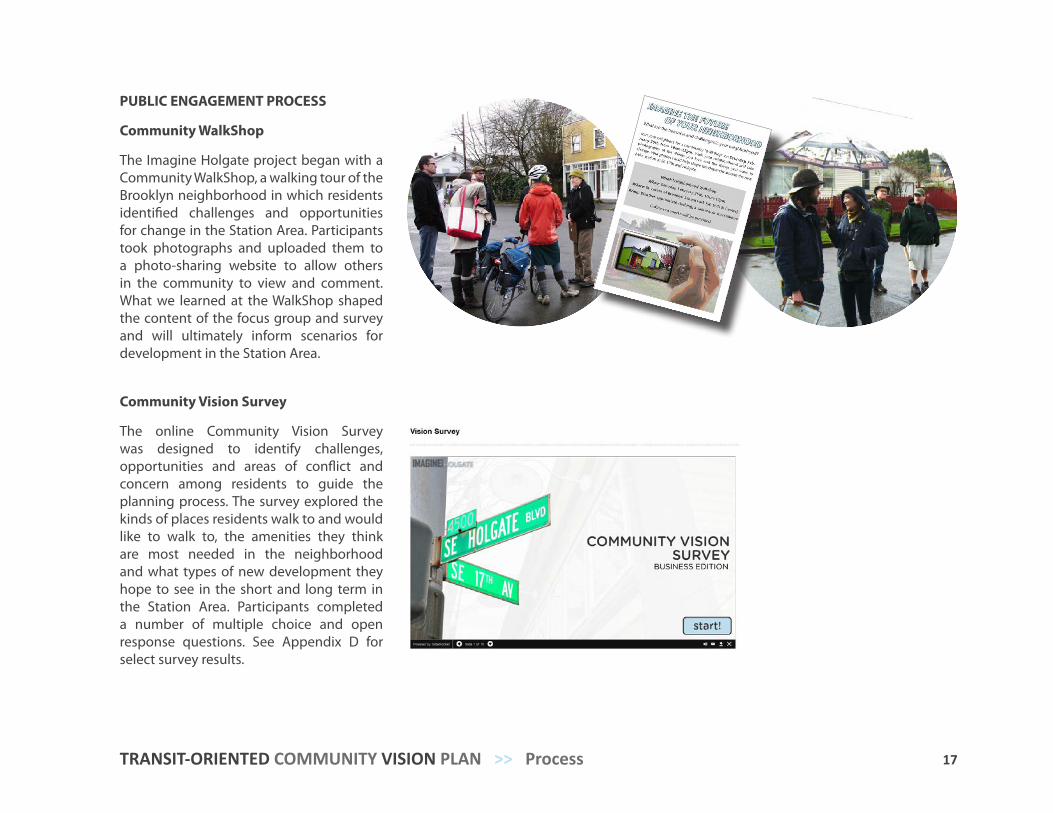
Community WalkShop
The Imagine Holgate project began with a Community WalkShop, a walking tour of the Brooklyn neighborhood in which residents identified challenges and opportunities for change in the Station Area. Participants took photographs and uploaded them to a photo-sharing website to allow others in the community to view and comment. What we learned at the WalkShop shaped the content of the focus group and survey and will ultimately inform scenarios for development in the Station Area.
Community Vision Survey
The online Community Vision Survey was designed to identify challenges, opportunities and areas of conflict and concern among residents to guide the planning process. The survey explored the kinds of places residents walk to and would like to walk to, the amenities they think are most needed in the neighborhood and what types of new development they hope to see in the short and long term in the Station Area. Participants completed a number of multiple choice and open response questions. See Appendix D for select survey results.
18 Process >> IMAGINE HOLGATE
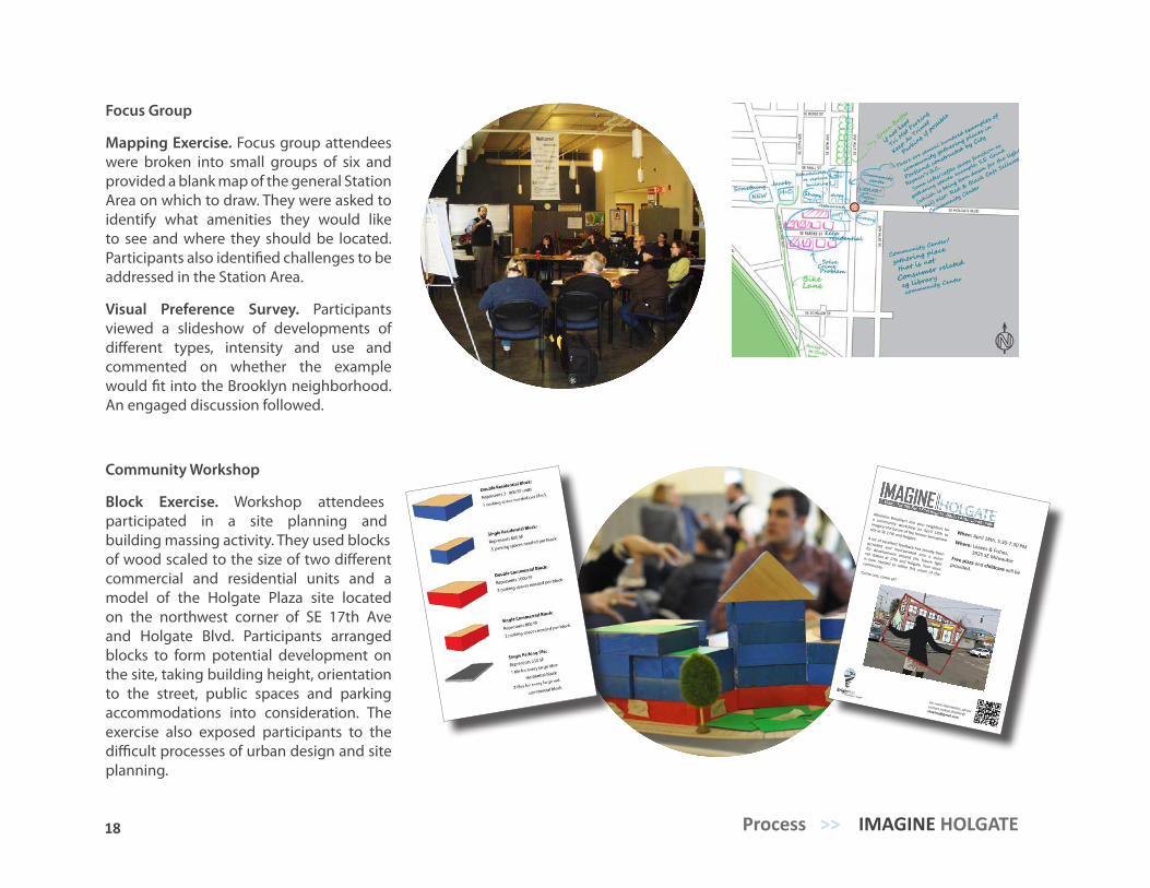
Focus Group
Mapping Exercise. Focus group attendees were broken into small groups of six and provided a blank map of the general Station Area on which to draw. They were asked to identify what amenities they would like to see and where they should be located. Participants also identified challenges to be addressed in the Station Area.
Visual Preference Survey. Participants viewed a slideshow of developments of different types, intensity and use and commented on whether the example would fit into the Brooklyn neighborhood. An engaged discussion followed.
Community Workshop
Block Exercise. Workshop attendees participated in a site planning and building massing activity. They used blocks of wood scaled to the size of two different commercial and residential units and a model of the Holgate Plaza site located on the northwest corner of SE 17th Ave and Holgate Blvd. Participants arranged blocks to form potential development on the site, taking building height, orientation to the street, public spaces and parking accommodations into consideration. The exercise also exposed participants to the difficult processes of urban design and site planning.
For more information, please contact Joshua Shaklee@
When: April 18th, 5:30-7:30 PMWhere: Loaves & Fishes,
3925 SE MilwaukieFree pizza and childcare will be provided.
Attention Brooklyn! Join your neighbors for
a community workshop on April 18th to
imagine the future of the former Semaphore
site at SE 17th and HolgateA lot of excellent feedback has already been
provided and incorporated into a vision
for development around the future light
rail station at 17th and Holgate. Your voice
is now needed to refine this vision of the
community.Come one, come all!
19 TRANSIT-ORIENTED COMMUNITY VISION PLAN >> Process
First Floor Exercise. Participants were asked to place different streetscape elements on a 16 foot long poster of a blank building facade secured to a wall, to communicate the qualities and amenities they desire in the pedestrian environment along the main corridors in the Station Area.
COMMUNITYWALKSHOP
FOCUSGROUP
COMMUNITY VISION
SURVEY
COMMUNITY WORKSHOP
FIGURE 10. Public engagement process.
20 Process >> IMAGINE HOLGATE
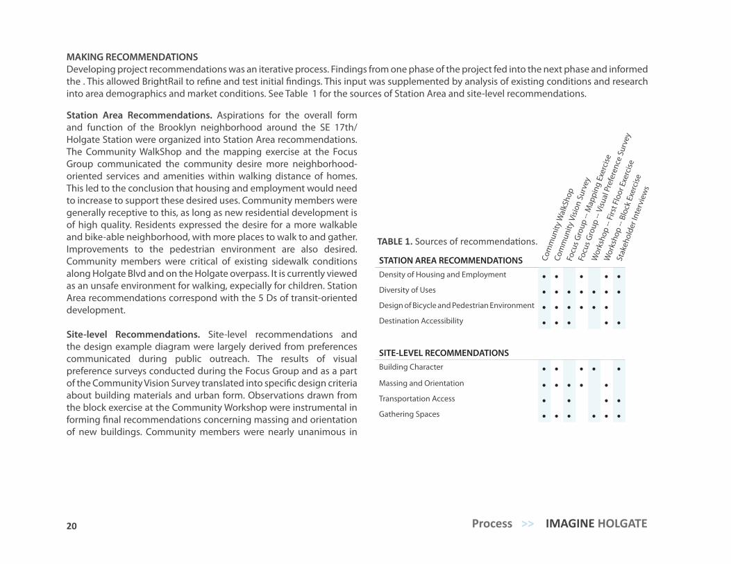
MAKING RECOMMENDATIONSDeveloping project recommendations was an iterative process. Findings from one phase of the project fed into the next phase and informed the . This allowed BrightRail to refine and test initial findings. This input was supplemented by analysis of existing conditions and research into area demographics and market conditions. See Table 1 for the sources of Station Area and site-level recommendations.
STATION AREA RECOMMENDATIONSDensity of Housing and Employment • • • • •Diversity of Uses • • • • • • •Design of Bicycle and Pedestrian Environment • • • • • •Destination Accessibility • • • • •
SITE-LEVEL RECOMMENDATIONSBuilding Character • • • • •Massing and Orientation • • • • •Transportation Access • • • •Gathering Spaces • • • • • •
Com
mun
ity W
alkS
hop
Focu
s Gro
up --
Visu
al P
refe
renc
e Su
rvey
Wor
ksho
p --
Firs
t Flo
or E
xerc
ise
Com
mun
ity V
ision
Sur
vey
Focu
s Gro
up --
Map
ping
Exe
rcise
Wor
ksho
p --
Bloc
k Ex
erci
se
Stak
ehol
der I
nter
view
s
TABLE 1. Sources of recommendations.
Station Area Recommendations. Aspirations for the overall form and function of the Brooklyn neighborhood around the SE 17th/Holgate Station were organized into Station Area recommendations. The Community WalkShop and the mapping exercise at the Focus Group communicated the community desire more neighborhood-oriented services and amenities within walking distance of homes. This led to the conclusion that housing and employment would need to increase to support these desired uses. Community members were generally receptive to this, as long as new residential development is of high quality. Residents expressed the desire for a more walkable and bike-able neighborhood, with more places to walk to and gather. Improvements to the pedestrian environment are also desired. Community members were critical of existing sidewalk conditions along Holgate Blvd and on the Holgate overpass. It is currently viewed as an unsafe environment for walking, expecially for children. Station Area recommendations correspond with the 5 Ds of transit-oriented development.
Site-level Recommendations. Site-level recommendations and the design example diagram were largely derived from preferences communicated during public outreach. The results of visual preference surveys conducted during the Focus Group and as a part of the Community Vision Survey translated into specific design criteria about building materials and urban form. Observations drawn from the block exercise at the Community Workshop were instrumental in forming final recommendations concerning massing and orientation of new buildings. Community members were nearly unanimous in
TRANSIT-ORIENTED COMMUNITY VISION PLAN
HOLGATE
A project of BrightRail Planning + Design
21 TRANSIT-ORIENTED COMMUNITY VISION PLAN >> Process
HOLGATEA Vision for the SE 17th/Holgate Station Area Community
EXISTING CONDITIONS ASSESSMENT
A project of BrightRail Planning + Design
EXISTING CONDITIONS ASSESSMENT
COMMUNITY ASPIRATIONS
REPORT
TRANSIT-ORIENTED
COMMUNITY VISION PLAN
IMAGINE HOLGATE WEBSITE
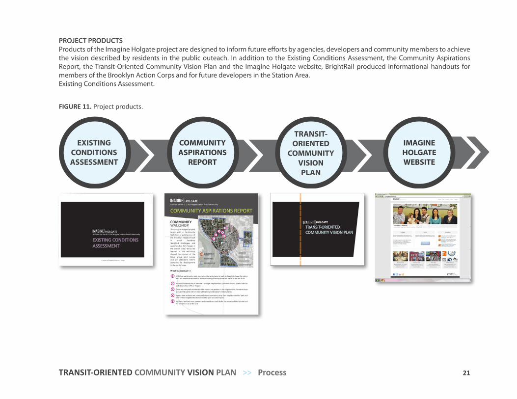
PROJECT PRODUCTSProducts of the Imagine Holgate project are designed to inform future efforts by agencies, developers and community members to achieve the vision described by residents in the public outeach. In addition to the Existing Conditions Assessment, the Community Aspirations Report, the Transit-Oriented Community Vision Plan and the Imagine Holgate website, BrightRail produced informational handouts for members of the Brooklyn Action Corps and for future developers in the Station Area.Existing Conditions Assessment.
FIGURE 11. Project products.
23 22 Process >> IMAGINE HOLGATE
ENGAGE SYNTHESIZEANALYZE SHARE
WALKSHOP FOCUSGROUP
COMMUNITY VISION
SURVEY
COMMUNITY WORKSHOP
EXISTING CONDITIONS ASSESSMENT
COMMUNITY ASPIRATIONS
REPORT
TRANSIT-ORIENTED
COMMUNITY VISION PLAN
PROCESS
OUTREACH
PRODUCTS
IMAGINE HOLGATE PROJECTFIGURE 12. Imagine Holgate project diagram.
23
Introduction Station Area Recommendations (5 Ds) Density of Housing and Employment Diversity of Uses Design of Bicycle and Pedestrian Environment Destination Accessibility Distance to TransitAction Items
RECOM
MEN
DATIO
NS
STATION
AREA
4
24 Existing Conditions >> IMAGINE HOLGATE
With the opening of the Portland-Milwaukie Light Rail (PMLR) line comes the opportunity to re-imagine the area around the future SE 17th/Holgate Station. Members of the station area community participated in a visioning process to express what they value about their neighborhood, the types and character of development they would like to see and how light rail could be leveraged to realize that vision. The following guidelines were developed from the community aspirations and designed to guide future development in the station area.
STATION AREA RECOMMENDATIONSThe categories below outline Station Area recommendations and were compiled through analysis of results from public engagement with community members and through additional research. Station Area recommendations follow the five Ds of transit orientation: Density of housing and employment, Design of the bicycle and pedestrian environment, Diversity of uses, Destination Accessibilty and Distance to Transit. These five components are the essential considerations for creating active, functional and thriving transit oriented development. They provide the framework for this project and the rubric for gauging future success of Station Area development.
SITE-LEVEL RECOMMENDATIONS
The site-level recommendations are intended to guide transit-supportive development and redevelopment at the level of the individual parcel. Using the Focus Area as an implementation example, these recommendations serve as a reference for community preferences and best practices for site-level design along commercial corridors in the Station Area. This information was gained from the Community Walkshop, visual preference surveys at the Focus Group and online, activities during the Community Workshop and through additional best practices research.
25 TRANSIT-ORIENTED COMMUNITY VISION PLAN >> Station Area Recommendations
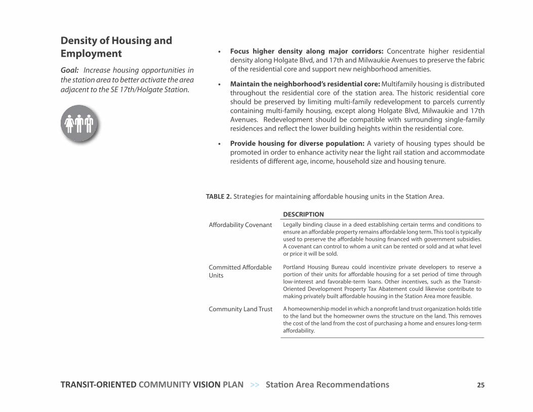
Density of Housing and EmploymentGoal: Increase housing opportunities in the station area to better activate the area adjacent to the SE 17th/Holgate Station.
• Focus higher density along major corridors: Concentrate higher residential density along Holgate Blvd, and 17th and Milwaukie Avenues to preserve the fabric of the residential core and support new neighborhood amenities.
• Maintain the neighborhood’s residential core: Multifamily housing is distributed throughout the residential core of the station area. The historic residential core should be preserved by limiting multi-family redevelopment to parcels currently containing multi-family housing, except along Holgate Blvd, Milwaukie and 17th Avenues. Redevelopment should be compatible with surrounding single-family residences and reflect the lower building heights within the residential core.
• Provide housing for diverse population: A variety of housing types should be promoted in order to enhance activity near the light rail station and accommodate residents of different age, income, household size and housing tenure.
DESCRIPTION
Affordability Covenant Legally binding clause in a deed establishing certain terms and conditions to ensure an affordable property remains affordable long term. This tool is typically used to preserve the affordable housing financed with government subsidies. A covenant can control to whom a unit can be rented or sold and at what level or price it will be sold.
Committed Affordable Units
Portland Housing Bureau could incentivize private developers to reserve a portion of their units for affordable housing for a set period of time through low-interest and favorable-term loans. Other incentives, such as the Transit-Oriented Development Property Tax Abatement could likewise contribute to making privately built affordable housing in the Station Area more feasible.
Community Land Trust A homeownership model in which a nonprofit land trust organization holds title to the land but the homeowner owns the structure on the land. This removes the cost of the land from the cost of purchasing a home and ensures long-term affordability.
TABLE 2. Strategies for maintaining affordable housing units in the Station Area.
26 Station Area Recommendations >> IMAGINE HOLGATE
HOLGATE BLVD
SE 17TH AVE
SE MILW
AUKIE AVE
SE MCLOUGHLIN BLVD
N
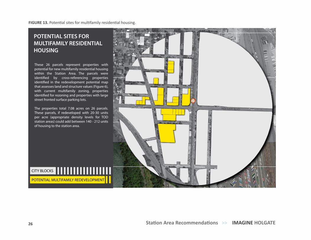
These 26 parcels represent properties with potential for new multifamily residential housing within the Station Area. The parcels were identi�ed by cross-referencing properties identi�ed in the redevelopment potential map that assesses land and structure values (Figure 6), with current multifamily zoning, properties identi�ed for rezoning and properties with large street fronted surface parking lots.
The properties total 7.08 acres on 26 parcels. These parcels, if redeveloped with 20-30 units per acre (appropriate density levels for TOD station areas) could add between 140 - 212 units of housing to the station area.
POTENTIAL MULTIFAMILY REDEVELOPMENT
CITY BLOCKS
POTENTIAL SITES FOR MULTIFAMILY RESIDENTIAL HOUSING
FIGURE 13. Potential sites for multifamily residential housing.
27 TRANSIT-ORIENTED COMMUNITY VISION PLAN >> Station Area Recommendations
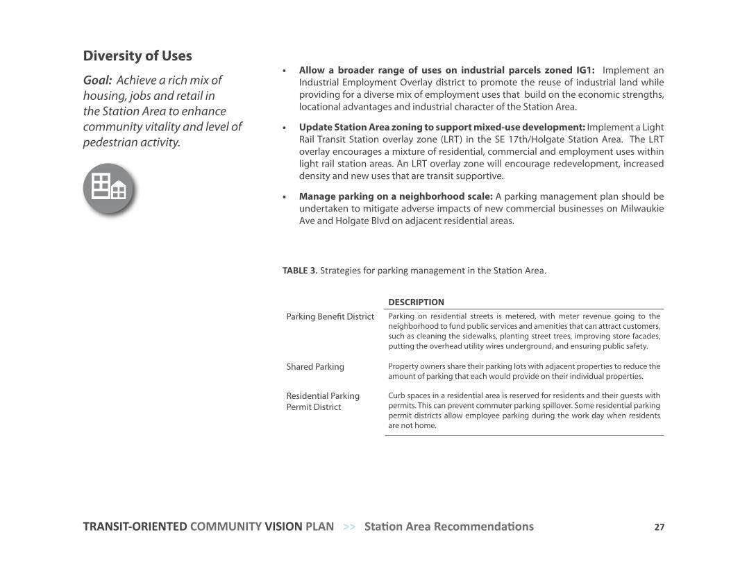
Diversity of Uses
Goal: Achieve a rich mix of housing, jobs and retail in the Station Area to enhance community vitality and level of pedestrian activity.
• Allow a broader range of uses on industrial parcels zoned IG1: Implement an Industrial Employment Overlay district to promote the reuse of industrial land while providing for a diverse mix of employment uses that build on the economic strengths, locational advantages and industrial character of the Station Area.
• Update Station Area zoning to support mixed-use development: Implement a Light Rail Transit Station overlay zone (LRT) in the SE 17th/Holgate Station Area. The LRT overlay encourages a mixture of residential, commercial and employment uses within light rail station areas. An LRT overlay zone will encourage redevelopment, increased density and new uses that are transit supportive.
• Manage parking on a neighborhood scale: A parking management plan should be undertaken to mitigate adverse impacts of new commercial businesses on Milwaukie Ave and Holgate Blvd on adjacent residential areas.
DESCRIPTION
Parking Benefit District Parking on residential streets is metered, with meter revenue going to the neighborhood to fund public services and amenities that can attract customers, such as cleaning the sidewalks, planting street trees, improving store facades, putting the overhead utility wires underground, and ensuring public safety.
Shared Parking Property owners share their parking lots with adjacent properties to reduce the amount of parking that each would provide on their individual properties.
Residential Parking Permit District
Curb spaces in a residential area is reserved for residents and their guests with permits. This can prevent commuter parking spillover. Some residential parking permit districts allow employee parking during the work day when residents are not home.
TABLE 3. Strategies for parking management in the Station Area.
28 Station Area Recommendations >> IMAGINE HOLGATE
HOLGATE BLVD
SE 17TH AVE
SE MILW
AUKIE AVE
SE MCLOUGHLIN BLVD
NVACANT LAND - INDUSTRIAL ALLOWED
SURFACE PARKING LOTS
CITY BLOCKS
VACANT AND UNDER-UTILIZED INDUSTRIAL SITES
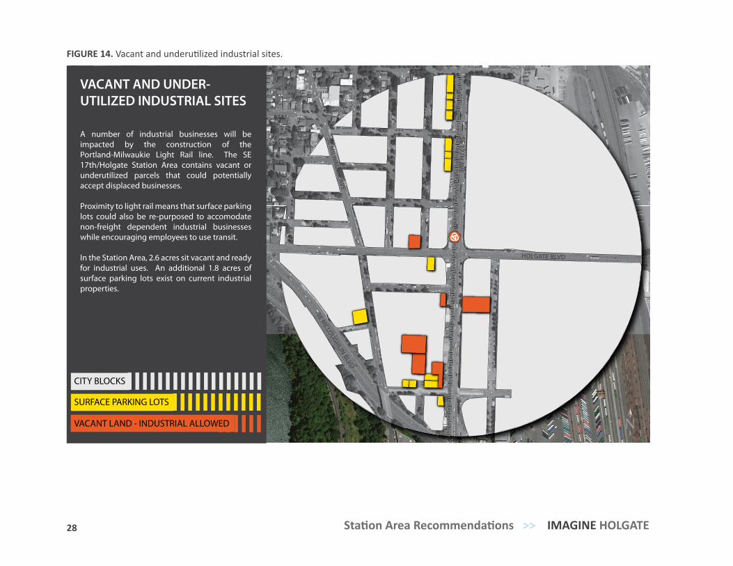
A number of industrial businesses will be impacted by the construction of the Portland-Milwaukie Light Rail line. The SE 17th/Holgate Station Area contains vacant or underutilized parcels that could potentially accept displaced businesses.
Proximity to light rail means that surface parking lots could also be re-purposed to accomodate non-freight dependent industrial businesses while encouraging employees to use transit.
In the Station Area, 2.6 acres sit vacant and ready for industrial uses. An additional 1.8 acres of surface parking lots exist on current industrial properties.
FIGURE 14. Vacant and underutilized industrial sites.
29 TRANSIT-ORIENTED COMMUNITY VISION PLAN >> Station Area Recommendations
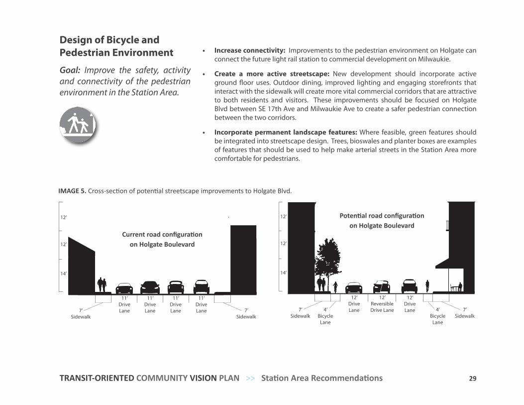
Design of Bicycle and Pedestrian Environment
Goal: Improve the safety, activity and connectivity of the pedestrian environment in the Station Area.
• Increase connectivity: Improvements to the pedestrian environment on Holgate can connect the future light rail station to commercial development on Milwaukie.
• Create a more active streetscape: New development should incorporate active ground floor uses. Outdoor dining, improved lighting and engaging storefronts that interact with the sidewalk will create more vital commercial corridors that are attractive to both residents and visitors. These improvements should be focused on Holgate Blvd between SE 17th Ave and Milwaukie Ave to create a safer pedestrian connection between the two corridors.
• Incorporate permanent landscape features: Where feasible, green features should be integrated into streetscape design. Trees, bioswales and planter boxes are examples of features that should be used to help make arterial streets in the Station Area more comfortable for pedestrians.
14’
12’
12’
4’ Bike Lane
12’ Drive Lane 12’ Drive Lane 4’ Bike Lane
7’ Sidewalk12’ ReversibleDrive Lane
7’ Sidewalk
IMAGE 5. Cross-section of potential streetscape improvements to Holgate Blvd.
14’
12’
12’
11’ Drive Lane 11’ Drive Lane 7’ Sidewalk11’ Drive Lane7’ Sidewalk 11’ Drive Lane
Current road configuration on Holgate Boulevard
Potential road configuration on Holgate Boulevard
12’ Drive Lane
12’ ReversibleDrive Lane
12’ Drive Lane7’
Sidewalk4’
BicycleLane
7’ Sidewalk
4’ Bicycle
Lane
11’ Drive Lane7’
Sidewalk7’
Sidewalk
11’ Drive Lane
11’ Drive Lane
11’ Drive Lane
12’
14’
12’
12’
14’
12’
30 Station Area Recommendations >> IMAGINE HOLGATE
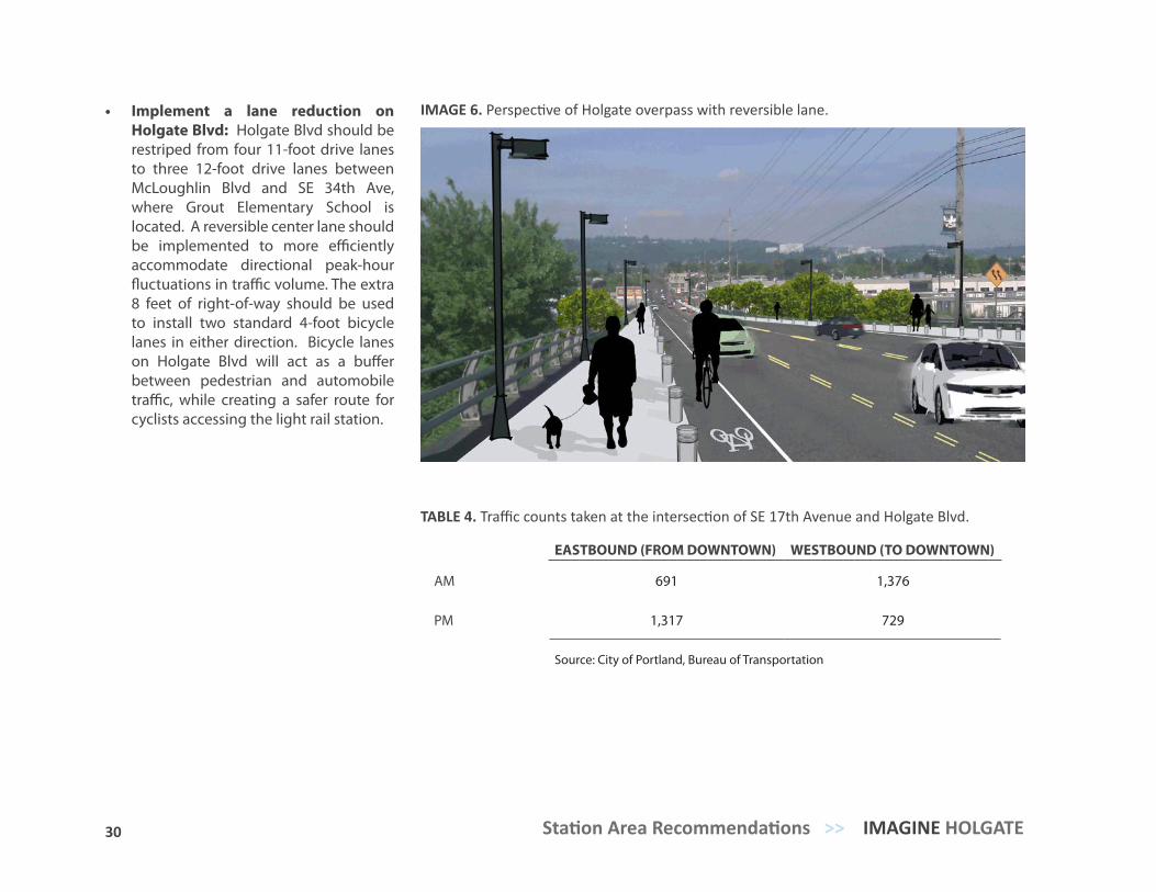
• Implement a lane reduction on Holgate Blvd: Holgate Blvd should be restriped from four 11-foot drive lanes to three 12-foot drive lanes between McLoughlin Blvd and SE 34th Ave, where Grout Elementary School is located. A reversible center lane should be implemented to more efficiently accommodate directional peak-hour fluctuations in traffic volume. The extra 8 feet of right-of-way should be used to install two standard 4-foot bicycle lanes in either direction. Bicycle lanes on Holgate Blvd will act as a buffer between pedestrian and automobile traffic, while creating a safer route for cyclists accessing the light rail station.
IMAGE 6. Perspective of Holgate overpass with reversible lane.
EASTBOUND (FROM DOWNTOWN) WESTBOUND (TO DOWNTOWN)
AM 691 1,376
PM 1,317 729
Source: City of Portland, Bureau of Transportation
TABLE 4. Traffic counts taken at the intersection of SE 17th Avenue and Holgate Blvd.
31 TRANSIT-ORIENTED COMMUNITY VISION PLAN >> Station Area Recommendations
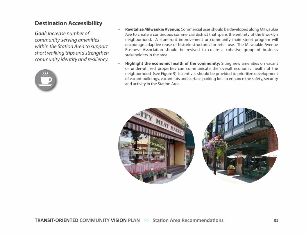
Destination Accessibility
Goal: Increase number of community-serving amenities within the Station Area to support short walking trips and strengthen community identity and resiliency.
• Revitalize Milwaukie Avenue: Commercial uses should be developed along Milwaukie Ave to create a continuous commercial district that spans the entirety of the Brooklyn neighborhood. A storefront improvement or community main street program will encourage adaptive reuse of historic structures for retail use. The Milwaukie Avenue Business Association should be revived to create a cohesive group of business stakeholders in the area.
• Highlight the economic health of the community: Siting new amenities on vacant or under-utilized properties can communicate the overall economic health of the neighborhood (see Figure 9). Incentives should be provided to prioritize development of vacant buildings, vacant lots and surface parking lots to enhance the safety, security and activity in the Station Area.
32 Station Area Recommendations >> IMAGINE HOLGATE
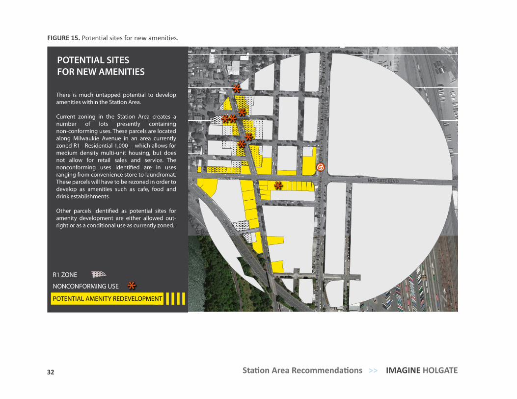
POTENTIAL AMENITY REDEVELOPMENT
HOLGATE BLVD
SE 17TH AVE
SE MILW
AUKIE AVE
SE MCLOUGHLIN BLV D
POTENTIAL SITES FOR NEW AMENITIES
There is much untapped potential to develop amenities within the Station Area.
Current zoning in the Station Area creates a number of lots presently containing non-conforming uses. These parcels are located along Milwaukie Avenue in an area currently zoned R1 - Residential 1,000 -- which allows for medium density multi-unit housing, but does not allow for retail sales and service. The nonconforming uses identi�ed are in uses ranging from convenience store to laundromat. These parcels will have to be rezoned in order to develop as amenities such as cafe, food and drink establishments.
Other parcels identi�ed as potential sites for amenity development are either allowed out-right or as a conditional use as currently zoned.
NONCONFORMING USE
N
R1 ZONE
FIGURE 15. Potential sites for new amenities.
33 TRANSIT-ORIENTED COMMUNITY VISION PLAN >> Station Area Recommendations
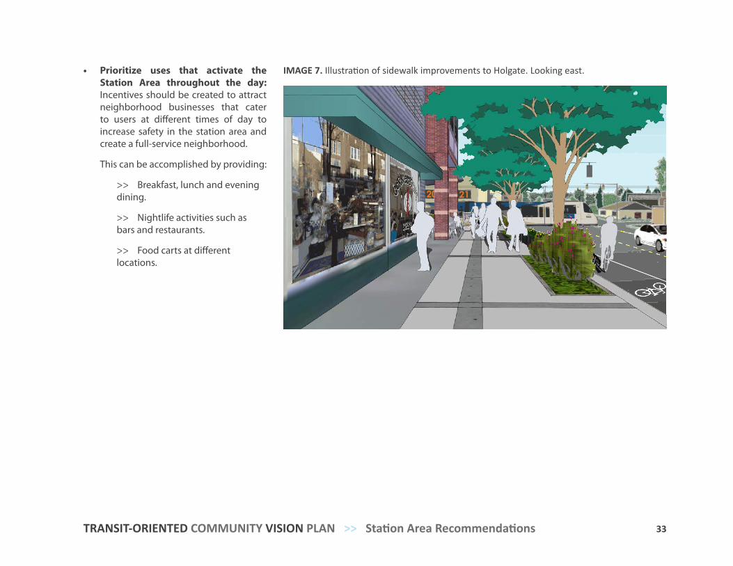
• Prioritize uses that activate the Station Area throughout the day: Incentives should be created to attract neighborhood businesses that cater to users at different times of day to increase safety in the station area and create a full-service neighborhood.
This can be accomplished by providing:
>> Breakfast, lunch and evening dining.
>> Nightlife activities such as bars and restaurants.
>> Food carts at different locations.
IMAGE 7. Illustration of sidewalk improvements to Holgate. Looking east.
34 Station Area Recommendations >> IMAGINE HOLGATE
Distance to Transit
Goal: Increase ridership for the SE 17th/Holgate Station.
• Increase housing density near station: Siting mixed-use housing development close to the SE 17th/Holgate Station creates built-in ridership.
• Encourage multimodal transportation connections: Providing infrastructure and amenities that support multimodal connections allows light rail transit to accommodate a larger cross-section of users. See Table 4 for strategies for facilitating multimodal connections in the Station Area.
• Improve connections to station: Improvements to pedestrian and bicycle connections over Brooklyn Yards from the station to adjacent neighborhoods can broaden ridership catchment area.
>> Holgate overpass improvements can make pedestrian travel safer and more enjoyable.
>> Wayfinding signage to SE 17th/Holgate Station from Creston- Kenilworth can increase ridership catchment area.
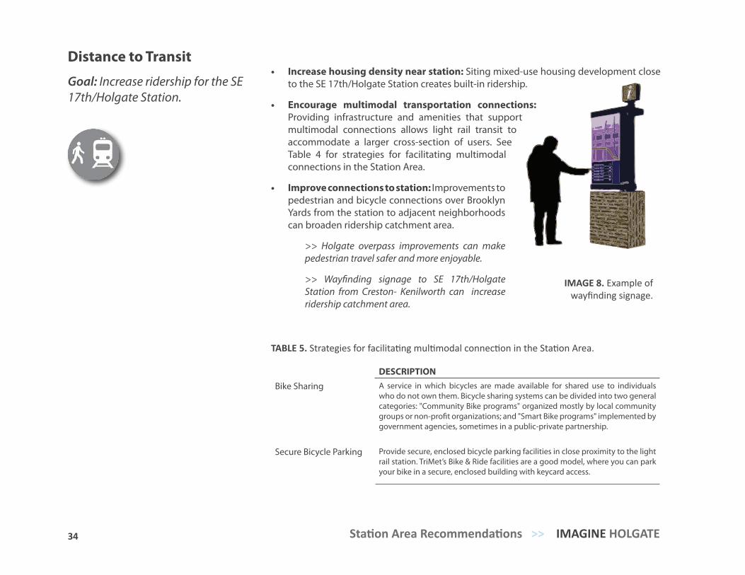
IMAGE 8. Example of wayfinding signage.
DESCRIPTION
Bike Sharing A service in which bicycles are made available for shared use to individuals who do not own them. Bicycle sharing systems can be divided into two general categories: "Community Bike programs" organized mostly by local community groups or non-profit organizations; and "Smart Bike programs" implemented by government agencies, sometimes in a public-private partnership.
Secure Bicycle Parking Provide secure, enclosed bicycle parking facilities in close proximity to the light rail station. TriMet’s Bike & Ride facilities are a good model, where you can park your bike in a secure, enclosed building with keycard access.
TABLE 5. Strategies for facilitating multimodal connection in the Station Area.
35 TRANSIT-ORIENTED COMMUNITY VISION PLAN >> Station Area Recommendations
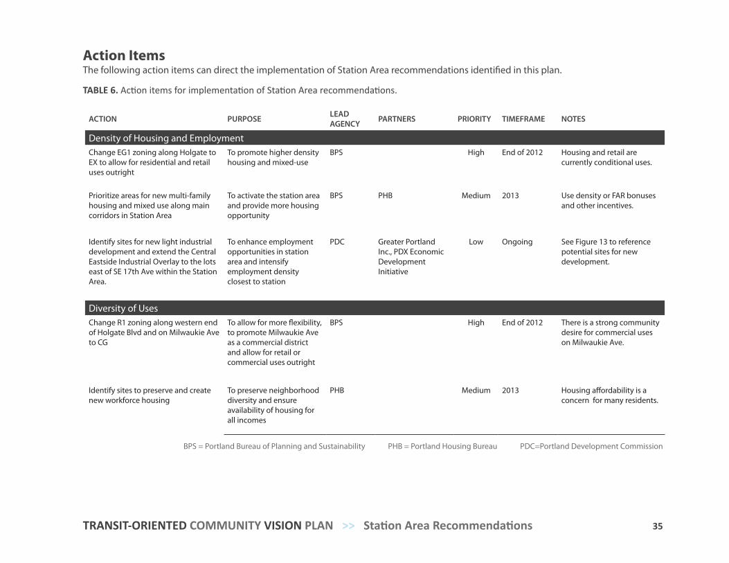
ACTION PURPOSE LEAD AGENCY PARTNERS PRIORITY TIMEFRAME NOTES
Density of Housing and EmploymentChange EG1 zoning along Holgate to EX to allow for residential and retail uses outright
To promote higher density housing and mixed-use
BPS High End of 2012 Housing and retail are currently conditional uses.
Prioritize areas for new multi-family housing and mixed use along main corridors in Station Area
To activate the station area and provide more housing opportunity
BPS PHB Medium 2013 Use density or FAR bonuses and other incentives.
Identify sites for new light industrial development and extend the Central Eastside Industrial Overlay to the lots east of SE 17th Ave within the Station Area.
To enhance employment opportunities in station area and intensify employment density closest to station
PDC Greater Portland Inc., PDX Economic Development Initiative
Low Ongoing See Figure 13 to reference potential sites for new development.
Diversity of UsesChange R1 zoning along western end of Holgate Blvd and on Milwaukie Ave to CG
To allow for more flexibility, to promote Milwaukie Ave as a commercial district and allow for retail or commercial uses outright
BPS High End of 2012 There is a strong community desire for commercial uses on Milwaukie Ave.
Identify sites to preserve and create new workforce housing
To preserve neighborhood diversity and ensure availability of housing for all incomes
PHB Medium 2013 Housing affordability is a concern for many residents.
Action ItemsThe following action items can direct the implementation of Station Area recommendations identified in this plan.
TABLE 6. Action items for implementation of Station Area recommendations.
BPS = Portland Bureau of Planning and Sustainability PHB = Portland Housing Bureau PDC=Portland Development Commission
36 Station Area Recommendations >> IMAGINE HOLGATE
ACTION PURPOSE LEAD AGENCY PARTNERS PRIORITY TIMEFRAME NOTES
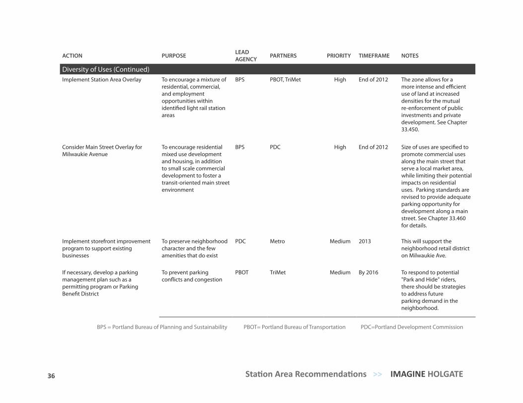
Diversity of Uses (Continued)Implement Station Area Overlay To encourage a mixture of
residential, commercial, and employment opportunities within identified light rail station areas
BPS PBOT, TriMet High End of 2012 The zone allows for a more intense and efficient use of land at increased densities for the mutual re-enforcement of public investments and private development. See Chapter 33.450.
Consider Main Street Overlay for Milwaukie Avenue
To encourage residential mixed use development and housing, in addition to small scale commercial development to foster a transit-oriented main street environment
BPS PDC High End of 2012 Size of uses are specified to promote commercial uses along the main street that serve a local market area, while limiting their potential impacts on residential uses. Parking standards are revised to provide adequate parking opportunity for development along a main street. See Chapter 33.460 for details.
Implement storefront improvement program to support existing businesses
To preserve neighborhood character and the few amenities that do exist
PDC Metro Medium 2013 This will support the neighborhood retail district on Milwaukie Ave.
If necessary, develop a parking management plan such as a permitting program or Parking Benefit District
To prevent parking conflicts and congestion
PBOT TriMet Medium By 2016 To respond to potential "Park and Hide" riders, there should be strategies to address future parking demand in the neighborhood.
BPS = Portland Bureau of Planning and Sustainability PBOT= Portland Bureau of Transportation PDC=Portland Development Commission
37 TRANSIT-ORIENTED COMMUNITY VISION PLAN >> Station Area Recommendations
ACTION PURPOSE LEAD AGENCY PARTNERS PRIORITY TIMEFRAME NOTES
Diversity of Uses (Continued)Implement Station Area Overlay To encourage a mixture of
residential, commercial, and employment opportunities within identified light rail station areas
BPS PBOT, TriMet High End of 2012 The zone allows for a more intense and efficient use of land at increased densities for the mutual re-enforcement of public investments and private development. See Chapter 33.450.
Consider Main Street Overlay for Milwaukie Avenue
To encourage residential mixed use development and housing, in addition to small scale commercial development to foster a transit-oriented main street environment
BPS PDC High End of 2012 Size of uses are specified to promote commercial uses along the main street that serve a local market area, while limiting their potential impacts on residential uses. Parking standards are revised to provide adequate parking opportunity for development along a main street. See Chapter 33.460 for details.
Implement storefront improvement program to support existing businesses
To preserve neighborhood character and the few amenities that do exist
PDC Metro Medium 2013 This will support the neighborhood retail district on Milwaukie Ave.
If necessary, develop a parking management plan such as a permitting program or Parking Benefit District
To prevent parking conflicts and congestion
PBOT TriMet Medium By 2016 To respond to potential "Park and Hide" riders, there should be strategies to address future parking demand in the neighborhood.
ACTION PURPOSE LEAD AGENCY PARTNERS PRIORITY TIMEFRAME NOTES
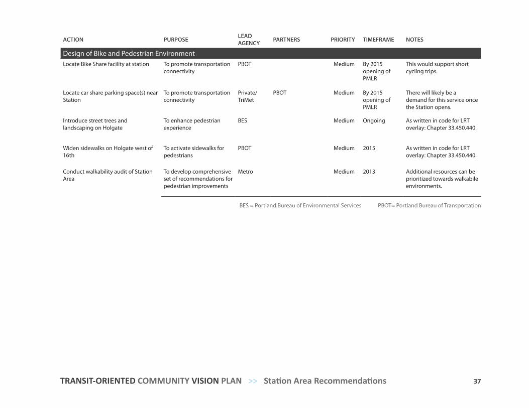
Design of Bike and Pedestrian EnvironmentLocate Bike Share facility at station To promote transportation
connectivityPBOT Medium By 2015
opening of PMLR
This would support short cycling trips.
Locate car share parking space(s) near Station
To promote transportation connectivity
Private/TriMet
PBOT Medium By 2015 opening of PMLR
There will likely be a demand for this service once the Station opens.
Introduce street trees and landscaping on Holgate
To enhance pedestrian experience
BES Medium Ongoing As written in code for LRT overlay: Chapter 33.450.440.
Widen sidewalks on Holgate west of 16th
To activate sidewalks for pedestrians
PBOT Medium 2015 As written in code for LRT overlay: Chapter 33.450.440.
Conduct walkability audit of Station Area
To develop comprehensive set of recommendations for pedestrian improvements
Metro Medium 2013 Additional resources can be prioritized towards walkabile environments.
BES = Portland Bureau of Environmental Services PBOT= Portland Bureau of Transportation
39 38 Station Area Recommendations >> IMAGINE HOLGATE
ACTION PURPOSE LEAD AGENCY PARTNERS PRIORITY TIMEFRAME NOTES
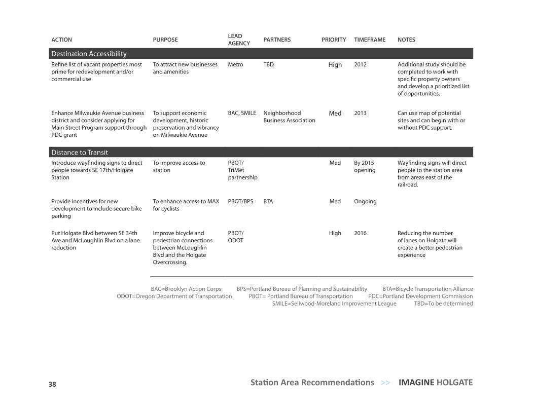
Destination AccessibilityRefine list of vacant properties most prime for redevelopment and/or commercial use
To attract new businesses and amenities
Metro TBD High 2012 Additional study should be completed to work with specific property owners and develop a prioritized list of opportunities.
Enhance Milwaukie Avenue business district and consider applying for Main Street Program support through PDC grant
To support economic development, historic preservation and vibrancy on Milwaukie Avenue
BAC, SMILE Neighborhood Business Association
Med 2013 Can use map of potential sites and can begin with or without PDC support.
Distance to TransitIntroduce wayfinding signs to direct people towards SE 17th/Holgate Station
To improve access to station
PBOT/TriMet partnership
Med By 2015 opening
Wayfinding signs will direct people to the station area from areas east of the railroad.
Provide incentives for new development to include secure bike parking
To enhance access to MAX for cyclists
PBOT/BPS BTA Med Ongoing
Put Holgate Blvd between SE 34th Ave and McLoughlin Blvd on a lane reduction
Improve bicycle and pedestrian connections between McLoughlin Blvd and the Holgate Overcrossing.
PBOT/ODOT
High 2016 Reducing the number of lanes on Holgate will create a better pedestrian experience
BAC=Brooklyn Action Corps BPS=Portland Bureau of Planning and Sustainability BTA=Bicycle Transportation AllianceODOT=Oregon Department of Transportation PBOT= Portland Bureau of Transportation PDC=Portland Development Commission
SMILE=Sellwood-Moreland Improvement League TBD=To be determined
39
RECOM
MEN
DATIO
NS
SITE-LEVEL
Design Example Building characterMassing and orientationTransportation AccessGathering Spaces
5
40 Site-level Recommendations >> IMAGINE HOLGATE
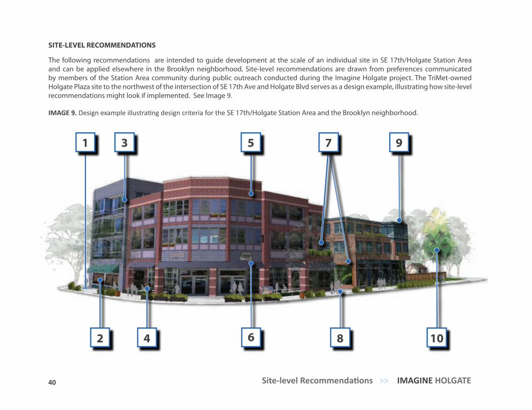
IMAGE 9. Design example illustrating design criteria for the SE 17th/Holgate Station Area and the Brooklyn neighborhood.
1
2
3 5 7
1
4 6 8 10
9
SITE-LEVEL RECOMMENDATIONS
The following recommendations are intended to guide development at the scale of an individual site in SE 17th/Holgate Station Area and can be applied elsewhere in the Brooklyn neighborhood. Site-level recommendations are drawn from preferences communicated by members of the Station Area community during public outreach conducted during the Imagine Holgate project. The TriMet-owned Holgate Plaza site to the northwest of the intersection of SE 17th Ave and Holgate Blvd serves as a design example, illustrating how site-level recommendations might look if implemented. See Image 9.
41 TRANSIT-ORIENTED COMMUNITY VISION PLAN >> Site-level Recommendations
6 7 8 109
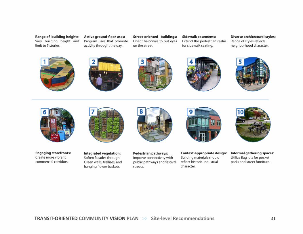
Range of building heights: Vary building height and limit to 5 stories.
Street-oriented buildings: Orient balconies to put eyes on the street.
Sidewalk easements: Extend the pedestrian realm for sidewalk seating.
Diverse architectural styles:Range of styles reflects neighborhood character.
Active ground-floor uses: Program uses that promote activity throught the day.
Engaging storefronts:Create more vibrant commercial corridors.
Integrated vegetation:Soften facades through Green walls, trellises, and hanging flower baskets.
Pedestrian pathways: Improve connectivity with public pathways and festival streets.
Informal gathering spaces: Utilize flag lots for pocket parks and street furniture.
Context-appropriate design:Building materials should reflect historic-industrial character.
52 3 41
42 Site-level Recommendations >> IMAGINE HOLGATE
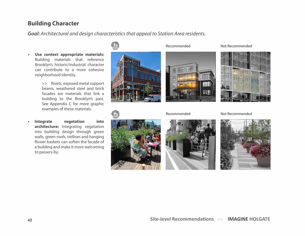
Building Character
Goal: Architectural and design characteristics that appeal to Station Area residents.
• Use context appropriate materials: Building materials that reference Brooklyn’s historic/industrial character can contribute to a more cohesive neighborhood identity.
>> Rivets, exposed metal support beams, weathered steel and brick facades are materials that link a building to the Brooklyn’s past. See Appendix C for more graphic examples of these materials.
Recommended Not Recommended
Recommended Not Recommended
• Integrate vegetation into architecture: Integrating vegetation into building design through green walls, green roofs, trellises and hanging flower baskets can soften the facade of a building and make it more welcoming to passers-by.
43 TRANSIT-ORIENTED COMMUNITY VISION PLAN >> Site-level Recommendations
Recommended Not Recommended
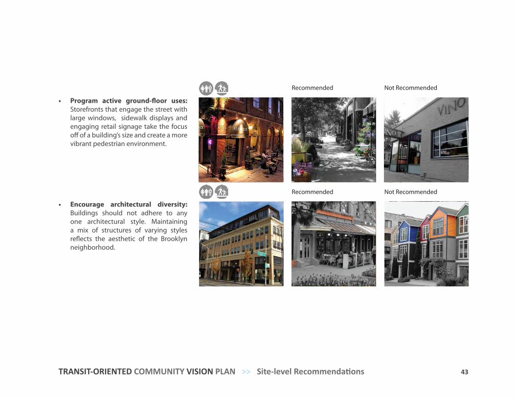
• Program active ground-floor uses: Storefronts that engage the street with large windows, sidewalk displays and engaging retail signage take the focus off of a building’s size and create a more vibrant pedestrian environment.
• Encourage architectural diversity: Buildings should not adhere to any one architectural style. Maintaining a mix of structures of varying styles reflects the aesthetic of the Brooklyn neighborhood.
Recommended Not Recommended
44 Site-level Recommendations >> IMAGINE HOLGATE
Recommended Not Recommended
Recommended Not Recommended
Massing and Orientation
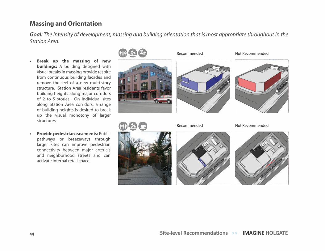
Goal: The intensity of development, massing and building orientation that is most appropriate throughout in the Station Area.
• Break up the massing of new buildings: A building designed with visual breaks in massing provide respite from continuous building facades and remove the feel of a new multi-story structure. Station Area residents favor building heights along major corridors of 2 to 5 stories. On individual sites along Station Area corridors, a range of building heights is desired to break up the visual monotony of larger structures.
• Provide pedestrian easements: Public pathways or breezeways through larger sites can improve pedestrian connectivity between major arterials and neighborhood streets and can activate internal retail space.
45 TRANSIT-ORIENTED COMMUNITY VISION PLAN >> Site-level Recommendations
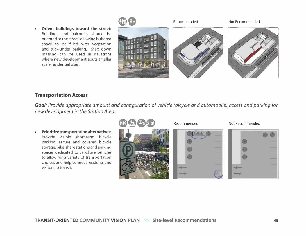
• Orient buildings toward the street: Buildings and balconies should be oriented to the street, allowing buffered space to be filled with vegetation and tuck-under parking. Step down massing can be used in situations where new development abuts smaller scale residential uses.
Recommended Not Recommended
• Prioritize transportation alternatives: Provide visible short-term bicycle parking, secure and covered bicycle storage, bike-share stations and parking spaces dedicated to car-share vehicles to allow for a variety of transportation choices and help connect residents and visitors to transit.
Recommended Not Recommended
Transportation Access
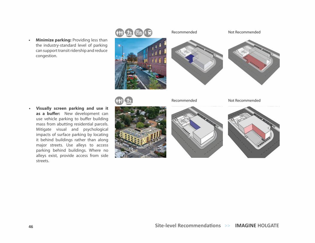
Goal: Provide appropriate amount and configuration of vehicle (bicycle and automobile) access and parking for new development in the Station Area.
46 Site-level Recommendations >> IMAGINE HOLGATE
• Visually screen parking and use it as a buffer: New development can use vehicle parking to buffer building mass from abutting residential parcels. Mitigate visual and psychological impacts of surface parking by locating it behind buildings rather than along major streets. Use alleys to access parking behind buildings. Where no alleys exist, provide access from side streets.
Recommended Not Recommended
Recommended Not Recommended
• Minimize parking: Providing less than the industry-standard level of parking can support transit ridership and reduce congestion.
47 TRANSIT-ORIENTED COMMUNITY VISION PLAN >> Site-level Recommendations
Gathering Spaces
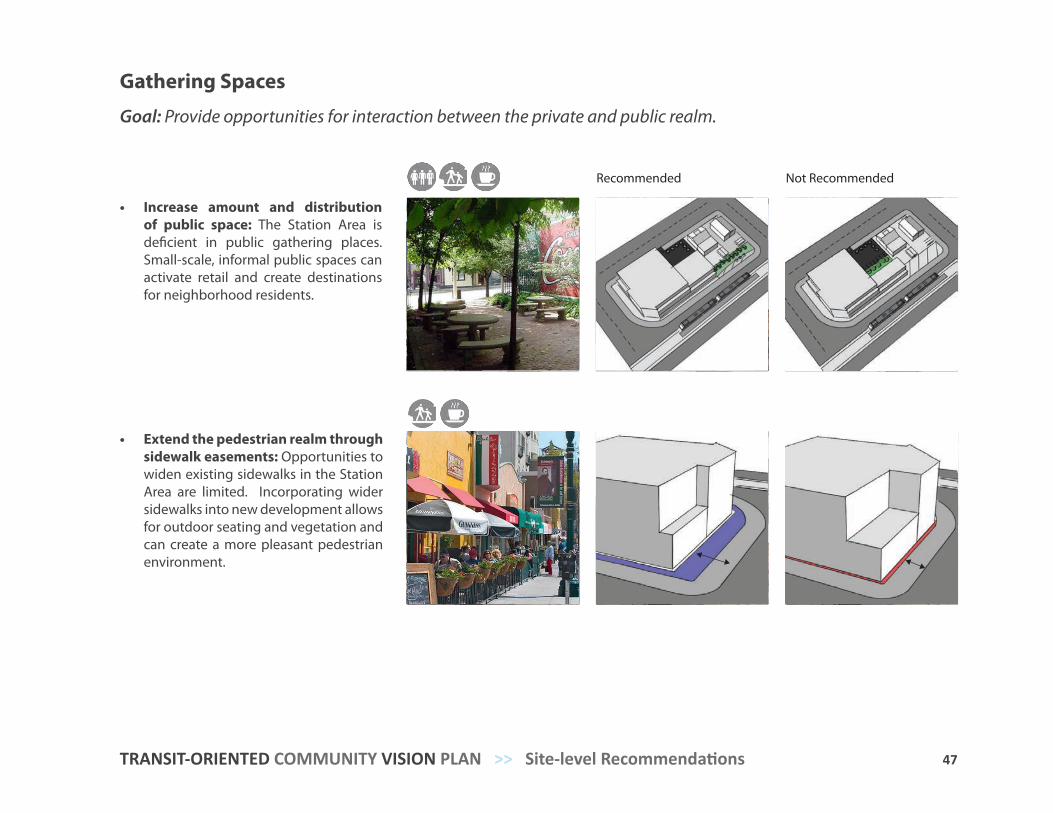
Goal: Provide opportunities for interaction between the private and public realm.
• Increase amount and distribution of public space: The Station Area is deficient in public gathering places. Small-scale, informal public spaces can activate retail and create destinations for neighborhood residents.
Recommended Not Recommended
• Extend the pedestrian realm through sidewalk easements: Opportunities to widen existing sidewalks in the Station Area are limited. Incorporating wider sidewalks into new development allows for outdoor seating and vegetation and can create a more pleasant pedestrian environment.
49
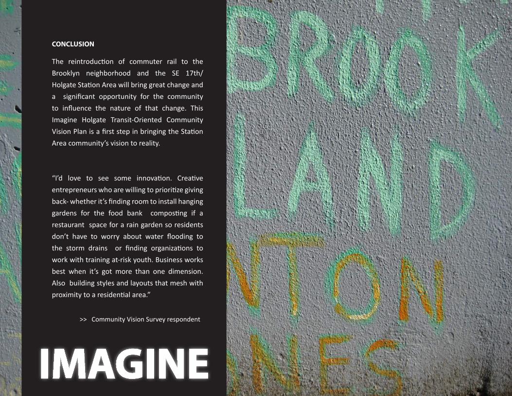
CONCLUSION
The reintroduction of commuter rail to the Brooklyn neighborhood and the SE 17th/Holgate Station Area will bring great change and a significant opportunity for the community to influence the nature of that change. This Imagine Holgate Transit-Oriented Community Vision Plan is a first step in bringing the Station Area community’s vision to reality.
“I’d love to see some innovation. Creative entrepreneurs who are willing to prioritize giving back- whether it’s finding room to install hanging gardens for the food bank composting if a restaurant space for a rain garden so residents don’t have to worry about water flooding to the storm drains or finding organizations to work with training at-risk youth. Business works best when it’s got more than one dimension. Also building styles and layouts that mesh with proximity to a residential area.”
>> Community Vision Survey respondent
IMAGINE
49
APPEN
DICES
ReferencesGlossary of TermsMaterials PaletteSelect Community Vision Survey ResultsExample Development Pro Forma
6
50 Appendices >> IMAGINE HOLGATE
APPENDIX A. References.
City of Portland Bureau of Planning. (1991). Brooklyn Neighborhood Plan, Portland, OR. Retrieved from
www.portlandonline.com/bps/index.cfm?a=88621&c=34248
City of Portland Bureau of Planning. (1997). East Portland Community Plan Summary Report. Portland, OR.
Retrieved from www.portlandonline.com/shared/cfm/image.cfm?id=89815
Cervero, Robert. (2008). Vehicle Trip Reduction Impacts of Transit-Oriented Housing. www.nctr.usf.edu/jpt/pdf/
JPT11-3Cervero.pdf
Ewing, Reid, US EPA. (1999). Pedestrian and Transit-Friendly Design: A Primer for Smart Growth.
Retrieved from www.epa.gov/smartgrowth/pdf/ptfd_primer.pdf
Fehr & Peers. (2005). The Ds: Smart Growth Project Evaluation.
Holtzclaw, J. (1994). Using Residential Patterns and Transit to Decrease Auto Dependence and Costs. San
Francisco: Natural Resources Defense Council, working paper.
Main Street Collaborative Consultants. (2006). Milwaukie Avenue Main Street Plan. Retrieved from Portland
State University, Program on Urban and Regional Planning. Retrieved from www. pdx.edu.usp/files/usp_
milwaukie_ave_main_st.pdf
51 TRANSIT-ORIENTED COMMUNITY VISION PLAN >> Appendices
Metro. (2009). Regional High Capacity Transit System Plan: 2035. Portland, OR. Retrieved from www.
nelsonnygaard.com/Documents/Reports/Metro-regional_High_Capacity_Transit_
System_Plan.pdf
Metro. (2008). Portland-Milwaukie Light Rail Project Locally Preferred Alternative Report. Portland, OR.
Retrieved from http://trimet.org/pdfs/pm/LPA_Report.pdf
Metro. (2011). Transit-Oriented Development Program Strategic Plan. Retrieved from http://library.
oregonmetro.gov/files//tod_strat_plan_execsum.pdf
TriMet. (2010). Portland-Milwaukie Light Rail Project: Final Environmental Impact Statement. Portland,
OR. Retrieved from http://trimet.org/pdfs/pm/FEIS/FEIS_Vol1_Chapters.pdf.
TriMet. (2008). South Corridor Supplemental Draft Environmental Impact Statement. Portland, OR.
Retrieved from http://trimet.org/pdfs/pm/sdeis/PMLR_SDEIS_Cover_TOC.pdf.
Ryan, Sherry & Lawrence, Frank F. (2009).Pedestrian Environments and Transit Ridership.
Retrieved from www.nctr.usf.edu/jpt/pdf/JPT12-1Ryan.pdf
Stewart, N. TriMet, (2011). Portland Milwaukie Light Rail History Presentation.
52 Appendices >> IMAGINE HOLGATE
Access Access is the portion of transit riders’ trips between their origin, such as home or work, and the station platform, and between the platform and their final destination. It includes both the trip to the station to catch a train, and the final leg of the journey from the station to the ultimate destination. The entire journey may involve many modes, such as walking, cycling or riding the bus or light rail.
Block ExerciseA public involvement activity in which community members used building blocks to create scale-models of development on the former Semaphore site, located on the Northwest corner of SE 17th and Holgate.
Catchment AreaThe area within a 10-minute walking distance of the SE 17th/Holgate Station that is not within a shorter walking distance to any other station along the PMLR.
ComparablesUnits either previously or currently on the market used to predict the value of some alternate real property that is reasonably similar in nature.
Environmental Impact Statement (EIS)Report which details any adverse economic, social, and environmental effects of a proposed transportation project for which federal funding is being sought. Adverse effects could include air, water, or noise pollution; destruction or disruption of natural resources; adverse employment effects; injurious displacement of people or businesses; or disruption of desirable community or regional growth.
APPENDIX B. Glossary of terms.Focus AreaThe TriMet owned property on the Northwest corner of SE 17th and Holgate which is slated for redevelopment in conjunction with the completion of the PMLR. The property is currently occupied by the Holgate Plaza strip development.
Market ContextThe economic factors and conditions which influence the type, intensity, and nature of development within the SE17th and Holgate station area.
MAXMAX stands for Metropolitan Area Express, TriMet’s light rail system serving the Portland metropolitan region.
Metro 2040 Growth ConceptA long-range plan designed with the participation of thousands of Oregonians in the 1990s. This innovative blueprint for the future, intended to guide growth and development over 50 years, is based on a set of shared values that continue to resonate throughout the region: thriving neighborhoods and communities, abundant economic opportunity, clean air and water, protecting streams and rivers, preserving farms and forestland, access to nature, and a sense of place. These are the reason people love to live here.
MobilityThe ability to move or be moved from place to place.
Mode, Intermodal, MultimodalForm of transportation, such as automobile, transit, bicycle and walking. Intermodal refers to the connections between modes and multimodal refers to the availability of transportation options within a system or corridor.
53 TRANSIT-ORIENTED COMMUNITY VISION PLAN >> Appendices
OutreachEfforts to offer everyone in a community the opportunity to participate in a planning project.
PMLRThe acronym used to refer to the Portland-Milwaukie Light Rail project, which includes the station located at SE 17th Ave and Holgate Blvd which serves as the focus for this report.
RidershipThe number of people who predictably utilise the PMLR via the station at SE 17th Ave and Holgate Blvd.
StakeholderA person, community or organization that has an interest in or may be affected by a transportation decision.
Station AreaThe area within a quarter mile of the SE 17th and Holgate station, excluding significant geographic barriers the prohibit walking, such as the Brooklyn rail yards to the east, and the Willamette River and adjacent steep slopes to the west
Station Area CommunityResidents, citizens, visitors, and business owners living and/or working within a station area.
Transit-oriented development (TOD)A higher-density, typically mixed-use (residential and commercial) form of development constructed adjacent or in close proximity to public transit, designed to reduce auto-dependence among residents and patrons by taking advantage of transit access
WalkshopA public involvement strategy which enlists community members to guide project organizers, but led by community members. Participants identified community assets and challenges BrightRail gained greater understanding of the Brooklyn neighborhood by participating in a resident-led tour of the Brooklyn neighborhood and SE 17th and Holgate Station area. Residents pointed out community assets as well as issues, and helped to shape the direction of the Imagine Holgate project. Photographs taken during the WalkShop were posted on a photosharing website where othe residents could comment and share based on the subject of the photographs.
Workforce HousingWorkforce housing is generally understood to mean affordable housing for households with earned income that is insufficient to secure quality housing in reasonable proximity to the workplace.
54 Appendices >> IMAGINE HOLGATE
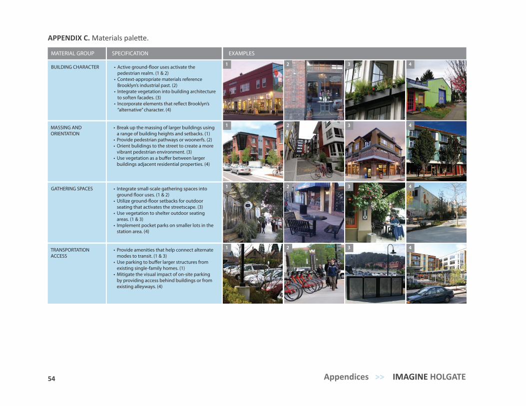
APPENDIX C. Materials palette.
BUILDING CHARACTER
MASSING AND ORIENTATION
GATHERING SPACES
TRANSPORTATION ACCESS
MATERIAL GROUP SPECIFICATION EXAMPLES
• pedestrian realm. (1 & 2)
• Context-appropriate materials reference Brooklyn’s industrial past. (2)
• Integrate vegetation into building architecture to soften facades. (3)
• “alternative” character. (4)
• Break up the massing of larger buildings using a range of building heights and setbacks. (1)
• Provide pedestrian pathways or woonerfs. (2)• Orient bulidings to the street to create a more
vibrant pedestrian environment. (3)•
buildings adjacent residential properties. (4)
• Integrate small-scale gathering spaces into
• seating that activates the streetscape. (3)
• Use vegetation to shelter outdoor seating areas. (1 & 3)
• Implement pocket parks on smaller lots in the station area. (4)
• Provide amenities that help connect alternate modes to transit. (1 & 3)
• existing single-family homes. (1)
• Mitigate the visual impact of on-site parking by providing access behind buildings or from existing alleyways. (4)
1 2 3 4
1 2 3 4
1 2 3 4
1 2 3 4
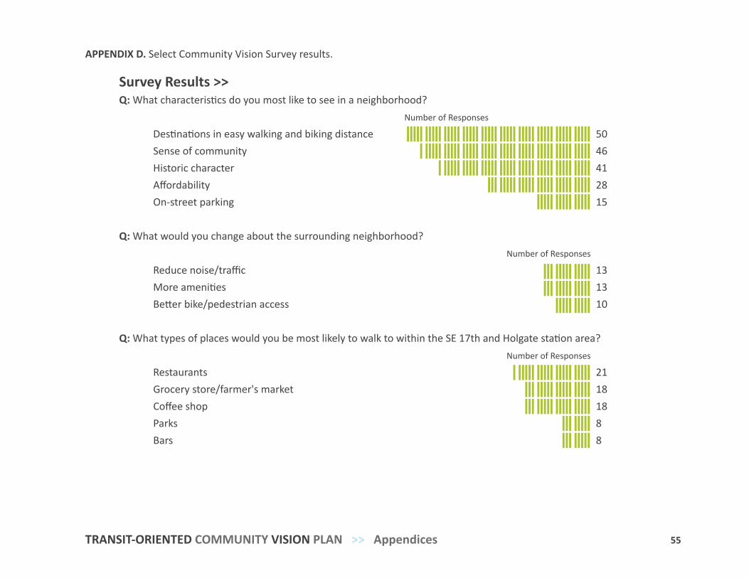
55 TRANSIT-ORIENTED COMMUNITY VISION PLAN >> Appendices
APPENDIX D. Select Community Vision Survey results.
Imaging Holgate is a project of BrightRail Planning + Design www.ImagineHolgate.org
The online Community Vision Survey was designed to identify challenges, opportunities and areas of opposition or concern among residents to guide the station area plan. The survey explored the kinds of places residents walk to and would like to walk to, the amenities they think are most needed in the neighborhood and what types of new development they hope to see in the short and long term in the station area.
Below are a selection of survey questions and responses that serve to identify community aspirations for the station area.
Survey Results >>Q: What characteristics do you most like to see in a neighborhood? Number of Responses
Destinations in easy walking and biking distance 50 Sense of community 46 Historic character 41 Affordability 28 On-street parking 15 Q: What would you change about the surrounding neighborhood? Number of Responses
Reduce noise/traffic 13 More amenities 13 Better bike/pedestrian access 10
Q: What types of places would you be most likely to walk to within the SE 17th and Holgate station area? Number of Responses Restaurants 21 Grocery store/farmer's market 18 Coffee shop 18 Parks 8 Bars 8
Q: How do you envision the area along SE 17th Avenue 10 years from now? Number of Responses
Mixed-use: commercial and residential together 32 Retail district: restaurants and storefronts 21 Employment-focused: more offices and light manufacturing 12 The way it is now: no significant change 8 Use of greenery or buffering between residential and industrial 6 Low-intensity industrial development North of Holgate 6
Q: How do you envision the area along SE Holgate Blvd 10 years from now? Number of Responses
Mixed-use: commercial and residential together 36 Retail district: restaurants and storefronts 29 More public community gathering spaces (indoor or outdoor) 14 Employment-focused: more offices and light manufacturing 8 More dining and grocery options 7 Better sidewalks and pedestrian infrastructure 7
Q: What new businesses would you most like to see come to your neighborhood? Number of Responses
Grocery/Market 47 Café/Bistro/Food Carts 45 Coffee Shop 20 Home Improvement/Gardening Supply Store 19 Boutique/Artisinal store 15 Bar/Night Life 15 Music/Record Store 8
What we learned >>
• Residents want more destinations and amenities to walk to, especially a grocery, market and restaurants
• Sense of community and desire for safety are most prevalent community concerns
• Residents hope new development will include greenery, more amenities and community gathering space
• While respondents are supportive of the new MAX line, some have concerns about parking and the scale of new development
COMMUNITY VISION SURVEY
12 Questions
62 Respondents
6 Average number of years
respondents have lived in area
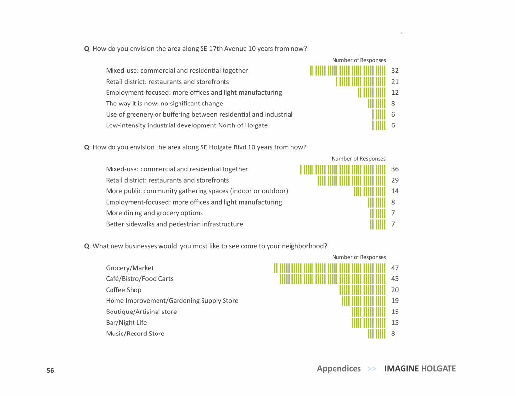
56 Appendices >> IMAGINE HOLGATE
Imaging Holgate is a project of BrightRail Planning + Design www.ImagineHolgate.org
The online Community Vision Survey was designed to identify challenges, opportunities and areas of opposition or concern among residents to guide the station area plan. The survey explored the kinds of places residents walk to and would like to walk to, the amenities they think are most needed in the neighborhood and what types of new development they hope to see in the short and long term in the station area.
Below are a selection of survey questions and responses that serve to identify community aspirations for the station area.
Survey Results >>Q: What characteristics do you most like to see in a neighborhood? Number of Responses
Destinations in easy walking and biking distance 50 Sense of community 46 Historic character 41 Affordability 28 On-street parking 15 Q: What would you change about the surrounding neighborhood? Number of Responses
Reduce noise/traffic 13 More amenities 13 Better bike/pedestrian access 10
Q: What types of places would you be most likely to walk to within the SE 17th and Holgate station area? Number of Responses Restaurants 21 Grocery store/farmer's market 18 Coffee shop 18 Parks 8 Bars 8
Q: How do you envision the area along SE 17th Avenue 10 years from now? Number of Responses
Mixed-use: commercial and residential together 32 Retail district: restaurants and storefronts 21 Employment-focused: more offices and light manufacturing 12 The way it is now: no significant change 8 Use of greenery or buffering between residential and industrial 6 Low-intensity industrial development North of Holgate 6
Q: How do you envision the area along SE Holgate Blvd 10 years from now? Number of Responses
Mixed-use: commercial and residential together 36 Retail district: restaurants and storefronts 29 More public community gathering spaces (indoor or outdoor) 14 Employment-focused: more offices and light manufacturing 8 More dining and grocery options 7 Better sidewalks and pedestrian infrastructure 7
Q: What new businesses would you most like to see come to your neighborhood? Number of Responses
Grocery/Market 47 Café/Bistro/Food Carts 45 Coffee Shop 20 Home Improvement/Gardening Supply Store 19 Boutique/Artisinal store 15 Bar/Night Life 15 Music/Record Store 8
What we learned >>
• Residents want more destinations and amenities to walk to, especially a grocery, market and restaurants
• Sense of community and desire for safety are most prevalent community concerns
• Residents hope new development will include greenery, more amenities and community gathering space
• While respondents are supportive of the new MAX line, some have concerns about parking and the scale of new development
COMMUNITY VISION SURVEY
12 Questions
62 Respondents
6 Average number of years
respondents have lived in area
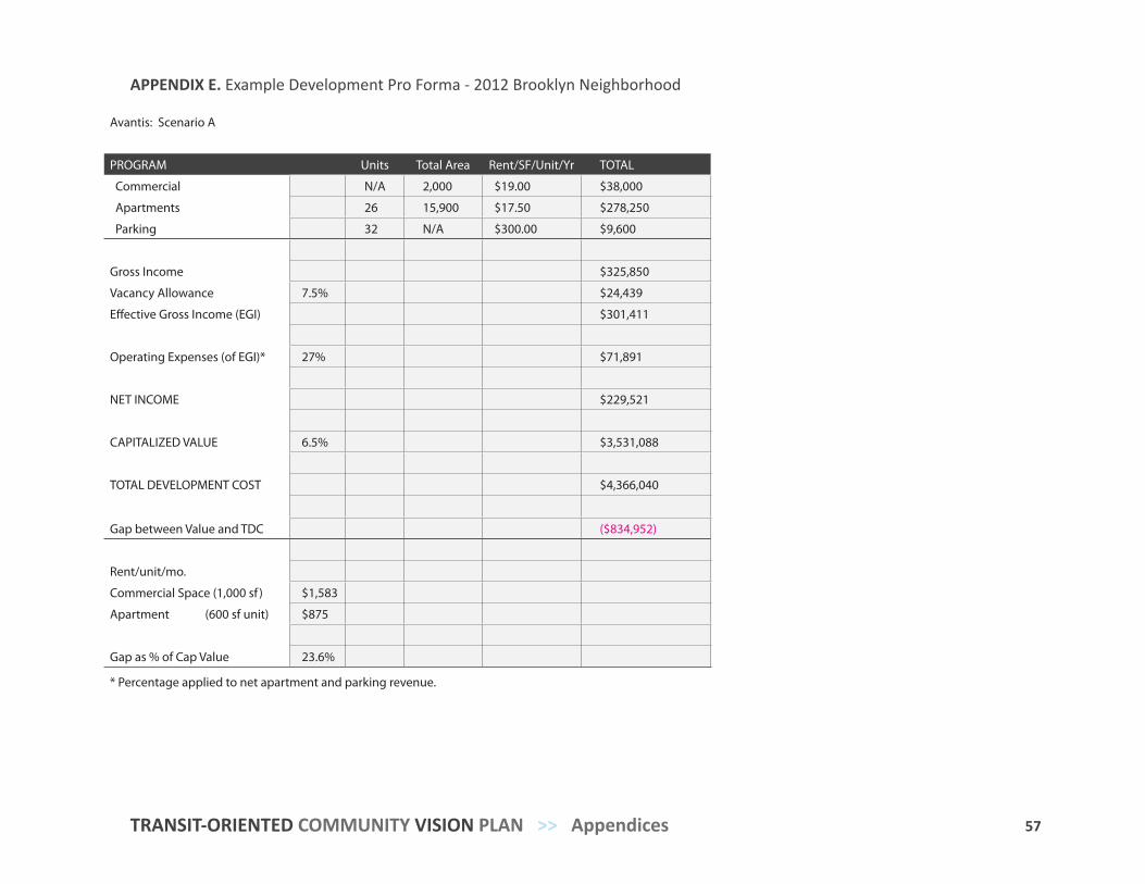
57 TRANSIT-ORIENTED COMMUNITY VISION PLAN >> Appendices
APPENDIX E. Example Development Pro Forma - 2012 Brooklyn Neighborhood
Avantis: Scenario A
PROGRAM Units Total Area Rent/SF/Unit/Yr TOTAL
Commercial N/A 2,000 $19.00 $38,000
Apartments 26 15,900 $17.50 $278,250
Parking 32 N/A $300.00 $9,600
Gross Income $325,850
Vacancy Allowance 7.5% $24,439
Effective Gross Income (EGI) $301,411
Operating Expenses (of EGI)* 27% $71,891
NET INCOME $229,521
CAPITALIZED VALUE 6.5% $3,531,088
TOTAL DEVELOPMENT COST $4,366,040
Gap between Value and TDC ($834,952)
Rent/unit/mo.
Commercial Space (1,000 sf ) $1,583
Apartment (600 sf unit) $875
Gap as % of Cap Value 23.6%
* Percentage applied to net apartment and parking revenue.
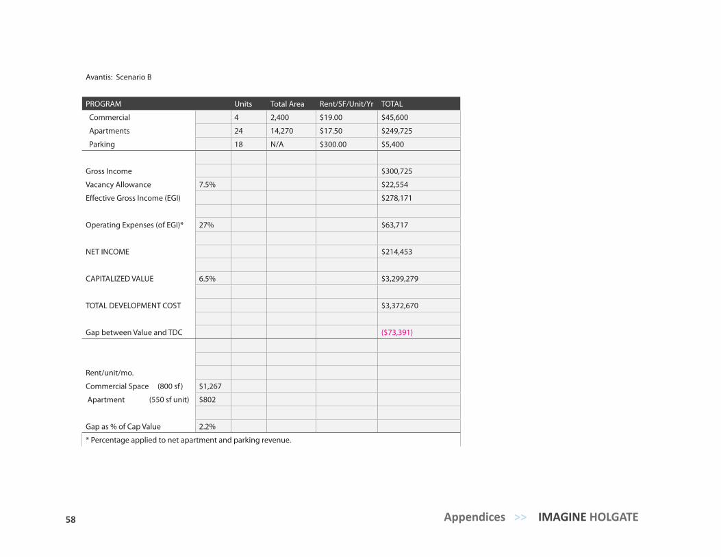
58 Appendices >> IMAGINE HOLGATE
Avantis: Scenario B
PROGRAM Units Total Area Rent/SF/Unit/Yr TOTAL
Commercial 4 2,400 $19.00 $45,600
Apartments 24 14,270 $17.50 $249,725
Parking 18 N/A $300.00 $5,400
Gross Income $300,725
Vacancy Allowance 7.5% $22,554
Effective Gross Income (EGI) $278,171
Operating Expenses (of EGI)* 27% $63,717
NET INCOME $214,453
CAPITALIZED VALUE 6.5% $3,299,279
TOTAL DEVELOPMENT COST $3,372,670
Gap between Value and TDC ($73,391)
Rent/unit/mo.
Commercial Space (800 sf ) $1,267
Apartment (550 sf unit) $802
Gap as % of Cap Value 2.2%
* Percentage applied to net apartment and parking revenue.