illawarra south coast south coast regional emergency management plan illawarra south coast region...
TRANSCRIPT
Illawarra South Coast
Regional Emergency
Management Plan
February 2019
11/awarra South Coast Regional Emergency Management Plan
Part 1 - Administration
Authority
The lllawarra South Coast Regional Emergency Management Plan (EMPLAN) has been
prepared by the lllawarra South Coast Regional Emergency Management Committee. The
plan was approved by the Regional Emergency Operations Controller and endorsed by the
State Emergency Management Committee in compliance with the State Emergency &
Rescue Management Act 1989 on 6 December 2018.
APPROVED
Regional Emergency Operations Controller
lllawarra South Coast Regional Emergency Management Committee Chair
Dated: 6 September 2018
ENDORSED
lllawarra South Coast Region EMPLAN 06 September 2018 Page2
Illawarra South Coast Regional Emergency Management Plan
Illawarra South Coast Region EMPLAN 13 February 2019 v2.1 Page 3
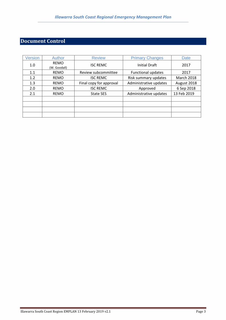
Document Control
Version Author Review Primary Changes Date
1.0 REMO
(W. Goodall) ISC REMC Initial Draft 2017
1.1 REMO Review subcommittee Functional updates 2017
1.2 REMO ISC REMC Risk summary updates March 2018
1.3 REMO Final copy for approval Administrative updates August 2018
2.0 REMO ISC REMC Approved 6 Sep 2018
2.1 REMO State SES Administrative updates 13 Feb 2019
Illawarra South Coast Regional Emergency Management Plan
Illawarra South Coast Region EMPLAN 13 February 2019 v2.1 Page 4
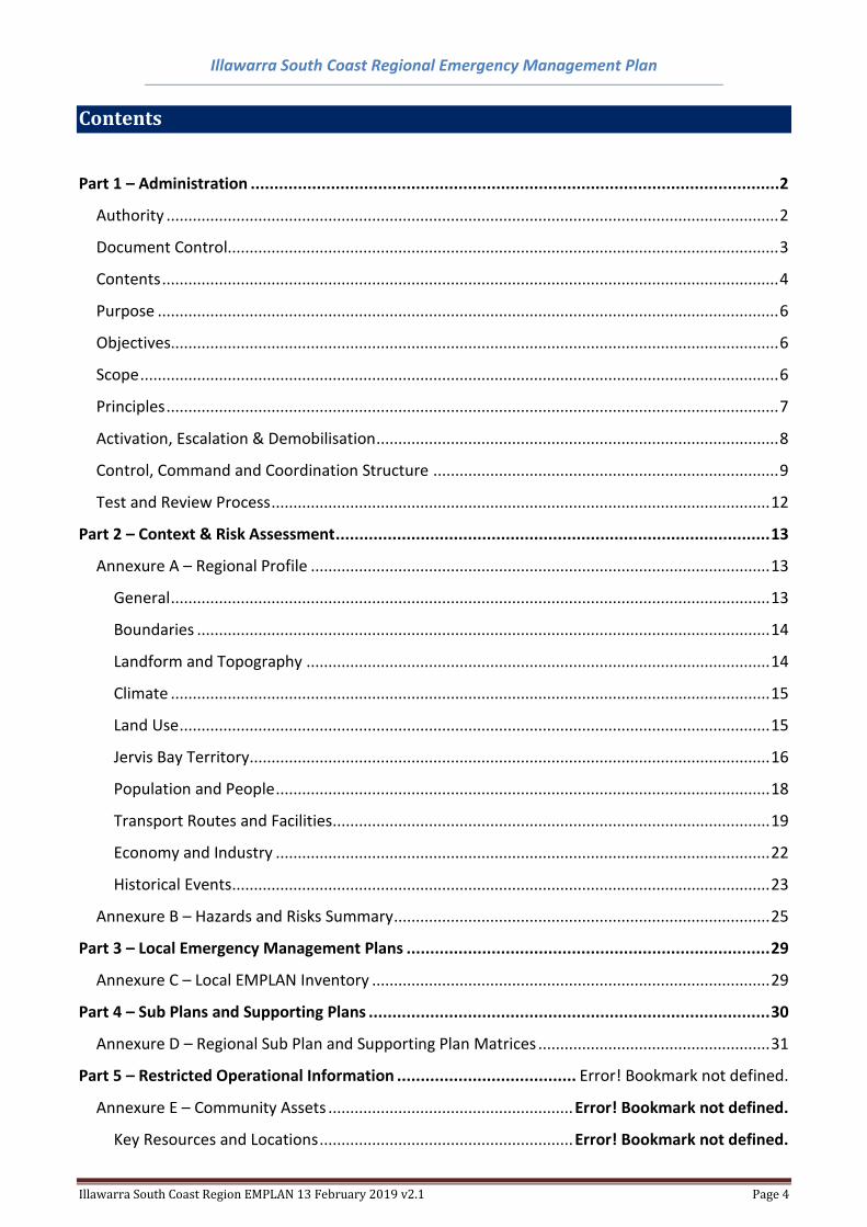
Contents
Part 1 – Administration ................................................................................................................ 2
Authority ............................................................................................................................................ 2
Document Control.............................................................................................................................. 3
Contents ............................................................................................................................................. 4
Purpose .............................................................................................................................................. 6
Objectives........................................................................................................................................... 6
Scope .................................................................................................................................................. 6
Principles ............................................................................................................................................ 7
Activation, Escalation & Demobilisation ............................................................................................ 8
Control, Command and Coordination Structure ............................................................................... 9
Test and Review Process .................................................................................................................. 12
Part 2 – Context & Risk Assessment ............................................................................................ 13
Annexure A – Regional Profile ......................................................................................................... 13
General ......................................................................................................................................... 13
Boundaries ................................................................................................................................... 14
Landform and Topography .......................................................................................................... 14
Climate ......................................................................................................................................... 15
Land Use ....................................................................................................................................... 15
Jervis Bay Territory ....................................................................................................................... 16
Population and People ................................................................................................................. 18
Transport Routes and Facilities .................................................................................................... 19
Economy and Industry ................................................................................................................. 22
Historical Events ........................................................................................................................... 23
Annexure B – Hazards and Risks Summary ...................................................................................... 25
Part 3 – Local Emergency Management Plans ............................................................................. 29
Annexure C – Local EMPLAN Inventory ........................................................................................... 29
Part 4 – Sub Plans and Supporting Plans ..................................................................................... 30
Annexure D – Regional Sub Plan and Supporting Plan Matrices ..................................................... 31
Part 5 – Restricted Operational Information ...................................... Error! Bookmark not defined.
Annexure E – Community Assets ........................................................ Error! Bookmark not defined.
Key Resources and Locations .......................................................... Error! Bookmark not defined.
Illawarra South Coast Regional Emergency Management Plan
Illawarra South Coast Region EMPLAN 13 February 2019 v2.1 Page 5
Key Infrastructure ........................................................................... Error! Bookmark not defined.
Local Evacuation Centres ................................................................ Error! Bookmark not defined.
Major Evacuation Centres ............................................................... Error! Bookmark not defined.
Annexure F – Regional Vulnerabilities ................................................ Error! Bookmark not defined.
Key Vulnerabilities (e.g. Facilities, Infrastructure, Populations, etc.) ............ Error! Bookmark not
defined.
Annexure G – Consequence Management Guides ............................. Error! Bookmark not defined.
Illawarra South Coast Regional Emergency Management Plan
Illawarra South Coast Region EMPLAN 13 February 2019 v2.1 Page 6
Purpose
Details arrangements for, prevention of, preparation for, response to and recovery from emergencies
within the Emergency Management Region covered by this plan.
It encompasses arrangements for:
• emergencies controlled by combat agencies;
• emergencies controlled by combat agencies and supported by the Regional Emergency
Operations Controller (REOCON);
• emergency operations for which there is no combat agency;
• circumstances where a combat agency has passed control to the REOCON; and,
• demobilisation and transition of control from response to recovery.
Objectives
The objectives of this plan are to:
• support Local Emergency Management Plans (EMPLANs) and augment them when required;
• identify trigger points for regional level activation, escalation and demobilisation;
• define participating organisation and Functional Area roles and responsibilities in preparation for, response to and recovery from emergencies;
• set out the control, co-ordination, support and liaison arrangements at the Regional level;
• detail activation and alerting arrangements for involved agencies at the Regional level; and
• detail arrangements for the acquisition and co-ordination of resources at the Regional level.
Scope
The plan describes the arrangements at Regional level to prevent, prepare for, respond to and
recover from emergencies and provides policy direction for the preparation of Sub Plans and
Supporting Plans. Further:
• this plan relies on effective implementation of the Governance framework for Emergency
Management;
• arrangements detailed in this plan assume that the resources upon which the plan relies are
available when required; and
• the effectiveness of arrangements detailed in this plan are dependent upon all involved
agencies preparing, testing and maintaining appropriate internal instructions, and/or
standing operating procedures.
Illawarra South Coast Regional Emergency Management Plan
Illawarra South Coast Region EMPLAN 13 February 2019 v2.1 Page 7
Principles
The following principles are applied in this plan:
a) The Emergency Risk Management (ERM) process is to be used as the basis for emergency
planning in New South Wales. This methodical approach to the planning process is to be
applied by Emergency Management Committees at all levels.
b) Responsibility for preparation, response and recovery rests initially at Local level. If Local
agencies and available resources are not sufficient they are augmented by those at Regional
level.
c) Control of emergency response and recovery operations is conducted at the lowest effective
level.
d) Agencies may deploy their own resources from their own service from outside the affected
Region if they are needed.
e) The Regional Emergency Operations Controller (REOCON) is responsible, when requested by
a combat agency, to co-ordinate the provision of resources support. EOCONs would not
normally assume control from a combat agency unless the situation can no longer be
contained. Where necessary, this should only be done after consultation with the State
Emergency Operations Controller (SEOCON) and agreement of the combat agency and the
appropriate level of control.
f) Emergency preparation, response and recovery operations should be conducted with all
agencies carrying out their normal functions wherever possible.
g) Prevention measures remain the responsibility of authorities/agencies charged by statute
with the responsibility.
Illawarra South Coast Regional Emergency Management Plan
Illawarra South Coast Region EMPLAN 13 February 2019 v2.1 Page 8
Activation, Escalation & Demobilisation
There are a number of Activation, Escalation and Demobilisation triggers that initiate and conclude
this Regional EMPLAN or elevation of the emergency to a State level.
Activation Triggers:
Support
• Designated Combat Agency has a regional level plan for emergency response;
• Whenever there is an impending or unforeseen emergency operation and Regional level support resources may be required;
Control
• Where there is no designated Combat Agency and a regional level response is required;
• Where it is necessary to coordinate two or more local level operations which are controlled by Emergency Operations Controllers;
• When the REOCON considers it necessary;
• When directed by the SEOCON to take control of an emergency response.
Escalation Triggers:
Local to Regional
• When an emergency grows beyond the capability of a Local EOC;
• When the emergency crosses two or more local emergency management boundaries and the change in control level may improve the situation;
• When significant Political, Environmental, Social, Technological or Economic impacts are foreseen;
• When directed by the SEOCON. Regional to State
• When an emergency grows beyond the capability of a Regional EOC;
• When the emergency crosses two or more Regional emergency management boundaries and the change in control level may improve the situation;
• When significant Political, Environmental, Social, Technological or Economic impacts are foreseen;
• When directed by the SEOCON. Demobilisation Triggers:
• When it is determined that the incident has scaled back to the extent a regional level response is
no longer required;
• When the response has transitioned into a longer-term recovery process and an appropriate handover to a recovery coordinator or committee occurs;
• When it is determined that no further control or support is required for the emergency. Note: The REMC may identify specific Regional triggers for activation, escalation and demobilisation beyond those listed above.
Illawarra South Coast Regional Emergency Management Plan
Illawarra South Coast Region EMPLAN 13 February 2019 v2.1 Page 9
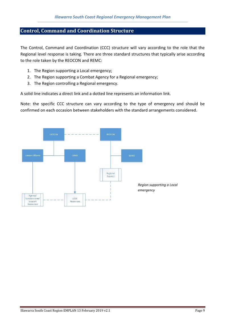
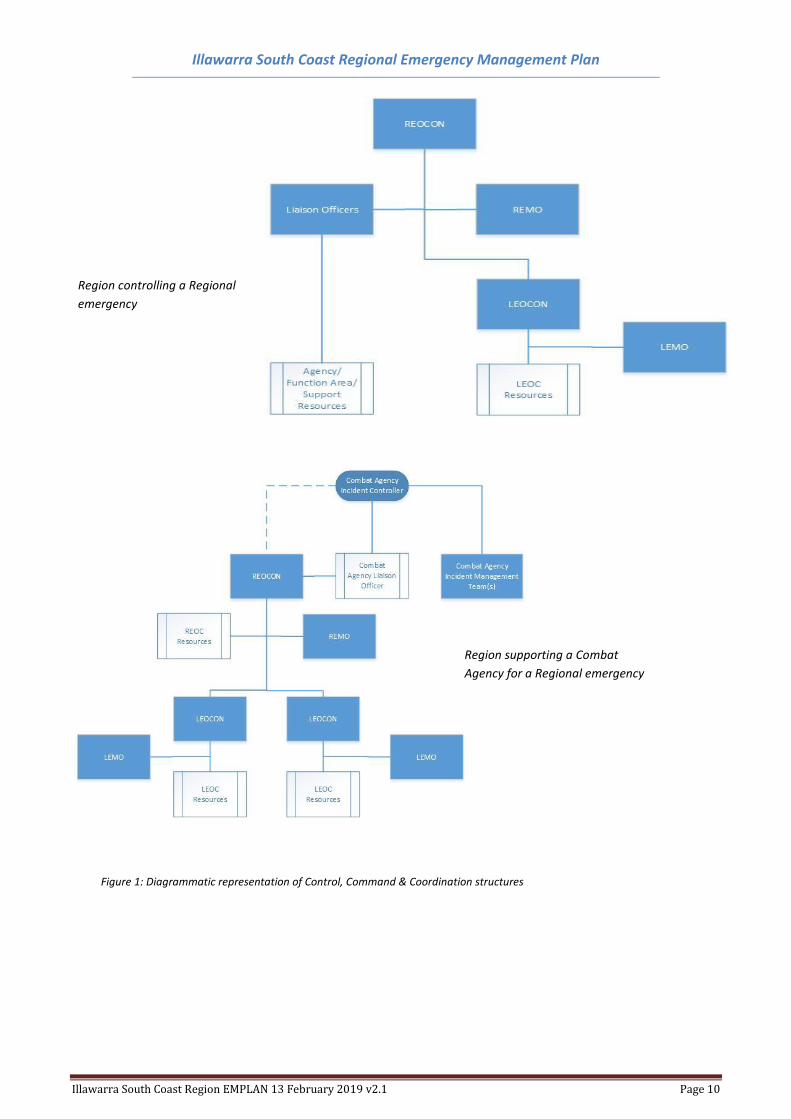
Control, Command and Coordination Structure
The Control, Command and Coordination (CCC) structure will vary according to the role that the
Regional level response is taking. There are three standard structures that typically arise according
to the role taken by the REOCON and REMC:
1. The Region supporting a Local emergency;
2. The Region supporting a Combat Agency for a Regional emergency;
3. The Region controlling a Regional emergency.
A solid line indicates a direct link and a dotted line represents an information link.
Note: the specific CCC structure can vary according to the type of emergency and should be
confirmed on each occasion between stakeholders with the standard arrangements considered.
Region supporting a Local
emergency
Illawarra South Coast Regional Emergency Management Plan
Illawarra South Coast Region EMPLAN 13 February 2019 v2.1 Page 10
Figure 1: Diagrammatic representation of Control, Command & Coordination structures
Region controlling a Regional
emergency
Region supporting a Combat
Agency for a Regional emergency
Illawarra South Coast Regional Emergency Management Plan
Illawarra South Coast Region EMPLAN 13 February 2019 v2.1 Page 11
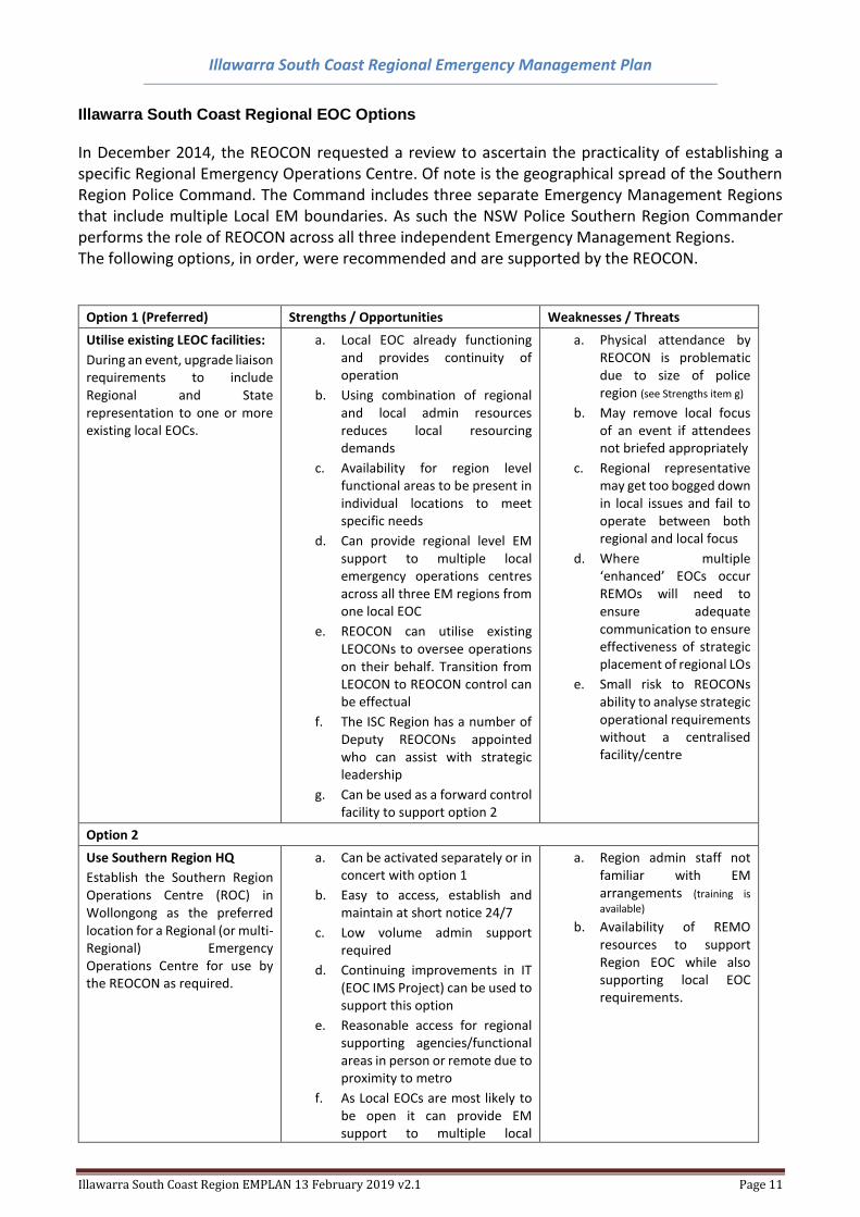
Illawarra South Coast Regional EOC Options
In December 2014, the REOCON requested a review to ascertain the practicality of establishing a specific Regional Emergency Operations Centre. Of note is the geographical spread of the Southern Region Police Command. The Command includes three separate Emergency Management Regions that include multiple Local EM boundaries. As such the NSW Police Southern Region Commander performs the role of REOCON across all three independent Emergency Management Regions. The following options, in order, were recommended and are supported by the REOCON.
Option 1 (Preferred) Strengths / Opportunities Weaknesses / Threats
Utilise existing LEOC facilities:
During an event, upgrade liaison requirements to include Regional and State representation to one or more existing local EOCs.
a. Local EOC already functioning and provides continuity of operation
b. Using combination of regional and local admin resources reduces local resourcing demands
c. Availability for region level functional areas to be present in individual locations to meet specific needs
d. Can provide regional level EM support to multiple local emergency operations centres across all three EM regions from one local EOC
e. REOCON can utilise existing LEOCONs to oversee operations on their behalf. Transition from LEOCON to REOCON control can be effectual
f. The ISC Region has a number of Deputy REOCONs appointed who can assist with strategic leadership
g. Can be used as a forward control facility to support option 2
a. Physical attendance by REOCON is problematic due to size of police region (see Strengths item g)
b. May remove local focus of an event if attendees not briefed appropriately
c. Regional representative may get too bogged down in local issues and fail to operate between both regional and local focus
d. Where multiple ‘enhanced’ EOCs occur REMOs will need to ensure adequate communication to ensure effectiveness of strategic placement of regional LOs
e. Small risk to REOCONs ability to analyse strategic operational requirements without a centralised facility/centre
Option 2
Use Southern Region HQ
Establish the Southern Region Operations Centre (ROC) in Wollongong as the preferred location for a Regional (or multi-Regional) Emergency Operations Centre for use by the REOCON as required.
a. Can be activated separately or in concert with option 1
b. Easy to access, establish and maintain at short notice 24/7
c. Low volume admin support required
d. Continuing improvements in IT (EOC IMS Project) can be used to support this option
e. Reasonable access for regional supporting agencies/functional areas in person or remote due to proximity to metro
f. As Local EOCs are most likely to be open it can provide EM support to multiple local
a. Region admin staff not familiar with EM arrangements (training is
available)
b. Availability of REMO resources to support Region EOC while also supporting local EOC requirements.
Illawarra South Coast Regional Emergency Management Plan
Illawarra South Coast Region EMPLAN 13 February 2019 v2.1 Page 12
emergency operations centres across all three EM regions
g. Relocation of Region Office with new Regional POC proposed allows for consideration of EM EOC requirements during fit-out
h. Use of admin support staff from Region level agencies as per SERM Act and EOC policy (training required)
The specific strategy undertaken by the REOCON will be determined at the time based on the scale and expected duration of the event.
Table 1: Illawarra South Coast CCC Options
Test and Review Process
The Illawarra South Coast Regional Emergency Management Committee (REMC) will review this Plan every three (3) years as a part of the continuous improvement cycle, or following any:
• Significant Regional change such as boundary changes, Agency/Functional Area/Supporting organisation changes, facilities, etc;
• activation of the Plan in response to an emergency;
• legislative changes affecting the Plan;
• reviews, inquiries and lessons learned that are relevant to the purpose of the plan;
• exercises conducted to test all or part of the Plan.
Illawarra South Coast Regional Emergency Management Plan
Illawarra South Coast Region EMPLAN 13 February 2019 v2.1 Page 13
Part 2 – Context & Risk Assessment
Annexure A – Regional Profile
General
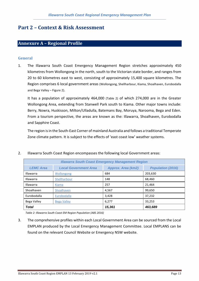
1. The Illawarra South Coast Emergency Management Region stretches approximately 450
kilometres from Wollongong in the north, south to the Victorian state border, and ranges from
20 to 60 kilometres east to west, consisting of approximately 15,400 square kilometres. The
Region comprises 6 local government areas (Wollongong, Shellharbour, Kiama, Shoalhaven, Eurobodalla
and Bega Valley – Figure 2).
It has a population of approximately 464,000 (Table 2) of which 274,000 are in the Greater
Wollongong Area, extending from Stanwell Park south to Kiama. Other major towns include:
Berry, Nowra, Huskisson, Milton/Ulladulla, Batemans Bay, Moruya, Narooma, Bega and Eden.
From a tourism perspective, the areas are known as the: Illawarra, Shoalhaven, Eurobodalla
and Sapphire Coast.
The region is in the South-East Corner of mainland Australia and follows a traditional Temperate
Zone climate pattern. It is subject to the effects of ‘east coast low’ weather systems.
2. Illawarra South Coast Region encompasses the following local Government areas:
Illawarra South Coast Emergency Management Region
LEMC Area Local Government Area Approx. Area (km2) Population (2016)
Illawarra Wollongong 684 203,630
Illawarra Shellharbour 148 68,460
Illawarra Kiama 257 21,464
Shoalhaven Shoalhaven 4,567 99,650
Eurobodalla Eurobodalla 3,428 37,232
Bega Valley Bega Valley 6,277 33,253
Total 15,361 463,689
Table 2: Illawarra South Coast EM Region Population (ABS 2016)
3. The comprehensive profiles within each Local Government Area can be sourced from the Local
EMPLAN produced by the Local Emergency Management Committee. Local EMPLANS can be
found on the relevant Council Website or Emergency NSW website.
Illawarra South Coast Regional Emergency Management Plan
Illawarra South Coast Region EMPLAN 13 February 2019 v2.1 Page 14
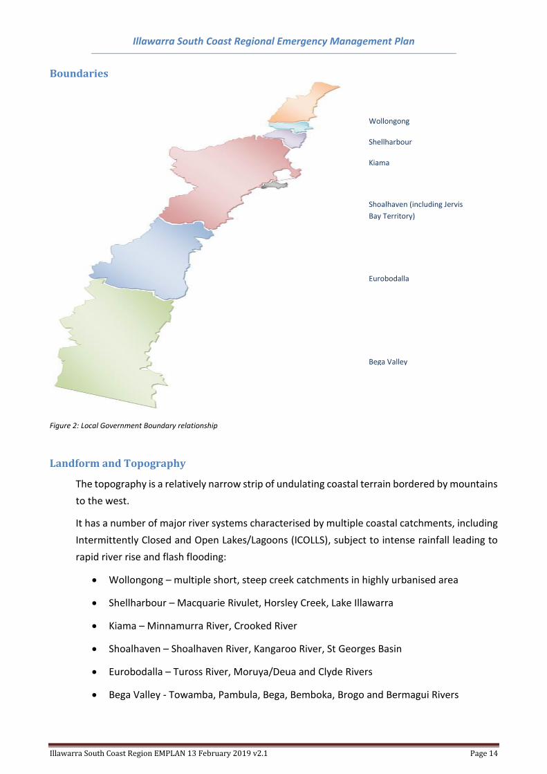
Boundaries
Figure 2: Local Government Boundary relationship
Landform and Topography
The topography is a relatively narrow strip of undulating coastal terrain bordered by mountains
to the west.
It has a number of major river systems characterised by multiple coastal catchments, including
Intermittently Closed and Open Lakes/Lagoons (ICOLLS), subject to intense rainfall leading to
rapid river rise and flash flooding:
• Wollongong – multiple short, steep creek catchments in highly urbanised area
• Shellharbour – Macquarie Rivulet, Horsley Creek, Lake Illawarra
• Kiama – Minnamurra River, Crooked River
• Shoalhaven – Shoalhaven River, Kangaroo River, St Georges Basin
• Eurobodalla – Tuross River, Moruya/Deua and Clyde Rivers
• Bega Valley - Towamba, Pambula, Bega, Bemboka, Brogo and Bermagui Rivers
Wollongong
Shellharbour
Kiama
Shoalhaven (including Jervis
Bay Territory)
Eurobodalla
Bega Valley
[SIDEBAR TITLE]
Illawarra South Coast Regional Emergency Management Plan
Illawarra South Coast Region EMPLAN 13 February 2019 v2.1 Page 15
Climate
The Illawarra South Coast Region is a well-defined temperate climate with clear summer and
winter periods. Rainfall is usually evenly distributed throughout the year across the Region.
LEMC Winter °C
Summer °C Annual Rainfall mm
Bega Valley 7 – 16 16 – 25 657
Eurobodalla 4 – 17 16 – 25 782
Shoalhaven 8 – 17 16 – 28 1200
Illawarra 9 – 16 19 – 25 1200
Table 3: Illawarra South Coast EM Region Weather Pattern (BoM)
Between January and June, the prevailing onshore (easterly) winds are often associated with
the effects of orographic lift due to the relative closeness of the escarpment. This often results
in higher than average rainfall during this period. Correspondingly, offshore winds tend to be
drier with westerly gales gusting more than 100kph not unusual in the latter half of the year.
East Coast Lows (ECLs) can occur at any time throughout the year and often lead to flash
flooding.
Land Use
Land use along the coast varies, and includes heavy industry (coal mining, steel making) in the
north, progressing to an agricultural environment (particularly dairy farming) in the central and
southern zones, with the forestry industry in the far south. Table 4 provides an approximation
of land usage across the Region. Individual Local Emergency Management Plans provide specific
details.
Illawarra South Coast Regional Emergency Management Plan
Illawarra South Coast Region EMPLAN 13 February 2019 v2.1 Page 16
Land Use Zone / Type / Classification
Area (km2)
% of Region
RU1 Primary Production 1934 12.6%
RU2 Rural Landscape 2167 14.1%
RU3 Forestry 2125 13.8%
RU4 Primary Production Small Lots 51 0.3%
RU5 Villages 13 0.1%
RU6 Transition 0.2 0.0%
R1 General Residential 20 0.1%
R2 Low Density Residential 176 1.1%
R3 Medium Density Residential 15 0.1%
R4 High Density Residential 0 0.0%
R5 Large Lot Residential 62 0.4%
B1 Neighbourhood Centres 0.7 0.0%
B2 Local Centres 3 0.0%
B3 Commercial Core 1 0.0%
B4 Mixed Use 3 0.0%
B5 Business Development 2 0.0%
B6 Enterprise Corridors 1 0.0%
B7 Business Parks 1 0.0%
B8 Metropolitan Centres 0 0.0%
IN1 General Industrial 14 0.1%
IN2 Light Industrial 8 0.1%
IN3 Heavy Industrial 13 0.1%
IN4 Working Waterfront 0.1 0.0%
SP1 Special Activities 52 0.3%
SP2 Infrastructure 115 0.7%
SP3 Tourist 6 0.0%
RE1 Public Recreation 62 0.4%
RE2 Private Recreation 18 0.1%
E1 National Parks and Nature Reserves 6307 41.1%
E2 Environmental Conservation 490 3.2%
E3 Environmental Management 926 6.0%
E4 Environmental Living 136 0.9%
W1 Natural Waterways 166 1.1%
W2 Recreational Waterways 83 0.5%
W3 Working Waterways 0.3 0.0%
Not specified 389.7 2.5%
Total 15361 100.0%
Table 4: Illawarra South Coast EM Region Land Usage (Source: Local EMPLANS)
Jervis Bay Territory
The Jervis Bay Territory is a Commonwealth Territory located on the southern side of Jervis Bay
surrounded by the Shoalhaven LGA. Commonwealth laws, including specific Jervis Bay Territory
Illawarra South Coast Regional Emergency Management Plan
Illawarra South Coast Region EMPLAN 13 February 2019 v2.1 Page 17
Ordinances and Rules and applied ACT laws are the basis of the Jervis Bay Territory’s legal
framework.
The Territory consists of approximately 65.7 km2 of land and 8.9 km2 marine reserve and
includes two small villages (Jervis Bay Village and Wreck Bay Village), HMAS Creswell (Naval
College), Jervis Bay Range Facility (military airfield), Bherwerre Trig (Defence) and Booderee
National Park (land and waters).
The Territory has a population of 391 (ABS 2016). Aboriginal and/or Torres Strait Islander
people make up 52% of the population. Tourism, including overnight camping, provides a
significant increase in people in the area throughout the year.
Service delivery involves the management of contracts and service delivery arrangements for:
• State-type services such as education, court services (ACT), community health and rural
fire services (NSW)
• Local government-type services (waste and recycling collections, library access, parks
and gardens – Shoalhaven City Council)
• Commercial contracts (e.g. electricity, water, waste water, residential housing)
The Territory has its own emergency management arrangements that complement the
arrangements in NSW. For the purposes of this Regional EMPLAN it is recognised that, while
independent, the Jervis Bay Territory is supported by NSW arrangements and, in particular, the
Shoalhaven Local Emergency Management Committee.
Illawarra South Coast Regional Emergency Management Plan
Illawarra South Coast Region EMPLAN 13 February 2019 v2.1 Page 18
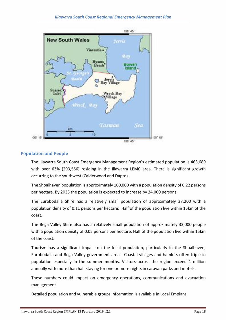
Population and People
The Illawarra South Coast Emergency Management Region’s estimated population is 463,689
with over 63% (293,556) residing in the Illawarra LEMC area. There is significant growth
occurring to the southwest (Calderwood and Dapto).
The Shoalhaven population is approximately 100,000 with a population density of 0.22 persons
per hectare. By 2035 the population is expected to increase by 24,000 persons.
The Eurobodalla Shire has a relatively small population of approximately 37,200 with a
population density of 0.11 persons per hectare. Half of the population live within 15km of the
coast.
The Bega Valley Shire also has a relatively small population of approximately 33,000 people
with a population density of 0.05 persons per hectare. Half of the population live within 15km
of the coast.
Tourism has a significant impact on the local population, particularly in the Shoalhaven,
Eurobodalla and Bega Valley government areas. Coastal villages and hamlets often triple in
population especially in the summer months. Visitors across the region exceed 1 million
annually with more than half staying for one or more nights in caravan parks and motels.
These numbers could impact on emergency operations, communications and evacuation
management.
Detailed population and vulnerable groups information is available in Local Emplans.
Illawarra South Coast Regional Emergency Management Plan
Illawarra South Coast Region EMPLAN 13 February 2019 v2.1 Page 19
Transport Routes and Facilities
Roads
The Princes Highway meanders north to south through the entire region commencing in
southern Sydney and entering Victoria south of Twofold Bay. The major road transport routes
are:
Wollongong LGA
• M1 Freeway Princes Highway (Waterfall to Yallah – also known locally as the F6)
• Lawrence Hargrave Drive, including the Sea Cliff Bridge
• Appin Road East/West (Illawarra to SW Sydney/Campbelltown)
• Bulli Pass East/West Northern Suburbs of Wollongong LGA to M1/Appin Road
• Mt Ousley North/South (a major section of the M1) central to Wollongong LGA
• Picton Road East/West M1 to Hume Hwy
• Five Islands Road/King Street and Shellharbour Road running north/south, east of Lake
Illawarra between Wollongong City and Shellharbour.
Shellharbour LGA
• Princes Highway (Yallah to Dunmore) running north/south, west of Lake Illawarra. Plans
are in place for a major bypass to avoid routine congestion at Albion Park Rail.
• Illawarra Highway East/West Shellharbour to Wingecarribee LGA
• Macquarie Pass (a major section of the Illawarra Highway) East/West Shellharbour to
Wingecarribee LGA (Not suitable for heavy vehicles).
Illawarra South Coast Regional Emergency Management Plan
Illawarra South Coast Region EMPLAN 13 February 2019 v2.1 Page 20
Kiama LGA
• Princes Highway (Dunmore to Foxground)
• Jamberoo Mountain Rd East/West Kiama LGA to Wingecarribee LGA (Not suitable for
heavy vehicles)
Shoalhaven LGA
• Princes Highway (Foxground to East Lynne)
• Kangaroo Valley East/West Nowra to Wingecarribee LGA (Not suitable for heavy vehicles)
• Main Road 92 (East/West Nowra to Canberra)
Eurobodalla
• Princes Highway (East Lynne to Dignams Creek)
• Kings Highway East/West Batemans Bay to Canberra
Bega Valley
• Princes Highway (Dignams Creek to Yambulla (NSW/Victoria border))
• Main Road 272 (Coastal road, Wallaga Lake to Merimbula)
• Snowy Mountains Hwy East West Bega to Snowy Monaro LGA
Rail
• The Sydney Train network, Illawarra Line, extends North/South through Wollongong,
Shellharbour, Kiama and Berry down to Bombaderry (Shoalhaven LGA). There is no rail
network south of Bomaderry.
The rail line travels through The Royal National Park and identified landslip areas between
Wollongong and Sydney.
The track is dual electrified to Dapto then single electrified to Kiama. From Kiama to
Bomaderry is the system is not electrified.
• CityRail network (Moss Vale Line) travels East/West linking Wollongong to the Southern
Highlands, via Robertson. This is a single, non‐electrified track.
Illawarra South Coast Regional Emergency Management Plan
Illawarra South Coast Region EMPLAN 13 February 2019 v2.1 Page 21
• Rail freight also utilises the Railcorp network within the Illawarra and northern Shoalhaven
LGAs
Ports & Harbours
Port Kembla
Located to the east of the Wollongong suburb of Port Kembla, the harbour of Port Kembla is
approximately 1.5 square kilometres at a dredged average depth of 6.1 metres. Diversification of
the port facilities since the 1980s has seen the port include general and break-bulk cargoes,
containers and motor vehicle imports, and bulk grain exports. Since late 2016 cruise ships have
begun to use the port thereby introducing over 2000 tourists per visit to the area.
Jervis Bay
Jervis Bay is an open bay approximately 100 square kilometres in size, near Nowra. The bay is unique
in that it is managed by a range of independent Federal, State and Territorial jurisdictions. The
Australian Defence Force has a bombing range on the northern side (Beecroft Peninsula) as well as
a naval base (HMAS Creswell) on the southern shore.
The Jervis Bay natural environment is protected in the Booderee National Park, Jervis Bay National
Park and the Jervis Bay Marine Park.
Twofold Bay
The Port of Eden is the southernmost declared port in NSW and services the south coast of NSW, as
well as eastern Victoria. It is a deep-water harbour with three wharves and cargo storage facilities
and is home to a large fishing fleet. Twofold Bay has the Royal Australian Navy munitions wharf and
a major woodchip loading wharf, both located on the southern side, opposite the town of Eden.
Cruise ships also use this port on occasions with the possibility of increasing tourism activities in the
area.
Other facilities
Ulladulla, Bermagui have small ports. There are also harbours at Shellharbour and Kiama. A large
public marina is currently under construction at Shellharbour and will be independent of the current
harbour.
Fishers, commercial and recreational, and recreational sailors are significant users of all ports and
harbours.
Illawarra South Coast Regional Emergency Management Plan
Illawarra South Coast Region EMPLAN 13 February 2019 v2.1 Page 22
Airports
There is one airport in the Illawarra Emergency Management Area located at Albion Park (Illawarra
Regional Airport) which caters for light aircraft, medical helicopter, skydiving, and flight training. It
is a CASA certified facility (Code 2) and has two sealed runways. Commercial passenger services
recommenced in late 2018.
The Shoalhaven has no official airport however the aerodrome at HMAS Albatross (Naval Air Base)
provides restricted facilities for commercial air services.
The Eurobodalla has one certified aerodrome (Moruya) with 2 sealed runways, runway 18/36
suitable for Code 3C aircraft operations is 1530 metres long and runway 04/22 for Code 2B aircraft
operations is 827 metres long. Regional Express Airlines (Rex) provide 3 Regular Passenger Transport
flights per day to and from Sydney. Other assets include: rescue helicopter, skydiving, flight training
and aircraft maintenance facilities. There is a fire bombing aviation command unit on site.
The Bega Valley has one commercial airport (Code 3), which is located south of Merimbula. Regional
Express Airlines (Rex) and Free Spirit Airlines provide passenger services to Sydney, Moruya and
Melbourne. The airport also supports the operations of the Air Ambulance, Royal Flying Doctor
Service, Rural Fire Service, freight operators, as well as local and visiting private and recreational
pilots.
Economy and Industry
The Illawarra South Coast Region provides a diverse range of employment, with health care and social
assistance having almost 14% of the workforce. The following table represents a summary of
employment across the region.
Illawarra South Coast Regional Emergency Management Plan
Illawarra South Coast Region EMPLAN 13 February 2019 v2.1 Page 23
Employment Category Employees % of
workforce
Health Care and Social Assistance 23094 13.8
Retail Trade 19804 11.9
Accommodation and Food Services 14421 8.6
Manufacturing 15417 9.2
Construction 12772 7.7
Education and Training 14978 9.0
Agriculture, Forestry and Fishing 2210 1.3
Public Administration and Safety 12408 7.4
Professional, Scientific and Technical Services 8365 5.0
Transport, Postal and Warehousing 7728 4.6
Wholesale Trade 4056 2.4
Administrative and Support Services 5065 3.0
Financial and Insurance Services 4989 3.0
Arts and Recreation Services 2600 1.6
Rental, Hiring and Real Estate Services 2740 1.6
Electricity, Gas, Water and Waste Services 1871 1.1
Information Media and Telecommunications 1978 1.2
Mining 2971 1.8
Other Sector or Inadequate Response 9291 5.6
Total 166758 100.0%
Table 5: Illawarra South Coast EM Region Workforce Categories (Local Government 2016)
Historical Events
East Coast Lows/Storms
Occur regularly in the Region resulting in:
• Flash flooding
• Power failure
• Structural damage, asbestos clean-up (Kiama Tornado 2013)
• Coastal inundation (2016)
• Land slips (Coledale 1988, Bulli Pass 1998, Kings Highway (multiple) and Snowy
Mountains Road)
Bushfires
Occur regularly in the region resulting in:
• Power failure
• Large scale evacuation and recovery centres (Tathra 2018)
Illawarra South Coast Regional Emergency Management Plan
Illawarra South Coast Region EMPLAN 13 February 2019 v2.1 Page 24
• Asbestos clean up
• Impact on town water supply in systems without filtration (Bermagui/Brogo schemes)
Main Road Incidents
• Significant impacts and/or extended closing of main roads (Mt Ousley, Princes Highway
Foxground, Macquarie Pass, Kangaroo Valley, Princes Highway between Nowra and
Batemans Bay, and Clyde Mountain
Illawarra South Coast Regional Emergency Management Plan
Illawarra South Coast Region EMPLAN 13 February 2019 v2.1 Page 25
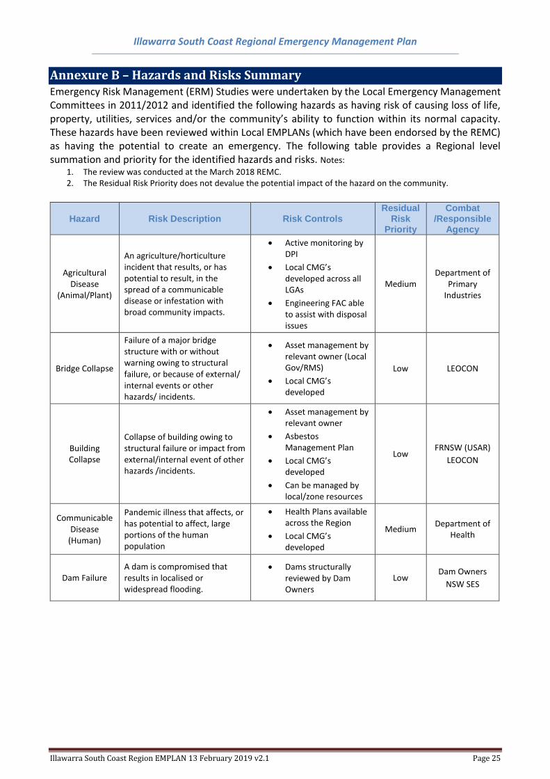
Annexure B – Hazards and Risks Summary Emergency Risk Management (ERM) Studies were undertaken by the Local Emergency Management Committees in 2011/2012 and identified the following hazards as having risk of causing loss of life, property, utilities, services and/or the community’s ability to function within its normal capacity. These hazards have been reviewed within Local EMPLANs (which have been endorsed by the REMC) as having the potential to create an emergency. The following table provides a Regional level summation and priority for the identified hazards and risks. Notes:
1. The review was conducted at the March 2018 REMC. 2. The Residual Risk Priority does not devalue the potential impact of the hazard on the community.
Hazard Risk Description Risk Controls Residual
Risk Priority
Combat /Responsible
Agency
Agricultural Disease
(Animal/Plant)
An agriculture/horticulture incident that results, or has potential to result, in the spread of a communicable disease or infestation with broad community impacts.
• Active monitoring by DPI
• Local CMG’s developed across all LGAs
• Engineering FAC able to assist with disposal issues
Medium Department of
Primary Industries
Bridge Collapse
Failure of a major bridge structure with or without warning owing to structural failure, or because of external/ internal events or other hazards/ incidents.
• Asset management by relevant owner (Local Gov/RMS)
• Local CMG’s developed
Low LEOCON
Building Collapse
Collapse of building owing to structural failure or impact from external/internal event of other hazards /incidents.
• Asset management by relevant owner
• Asbestos Management Plan
• Local CMG’s developed
• Can be managed by local/zone resources
Low FRNSW (USAR)
LEOCON
Communicable Disease
(Human)
Pandemic illness that affects, or has potential to affect, large portions of the human population
• Health Plans available across the Region
• Local CMG’s developed
Medium Department of
Health
Dam Failure A dam is compromised that results in localised or widespread flooding.
• Dams structurally reviewed by Dam Owners
Low Dam Owners
NSW SES
Illawarra South Coast Regional Emergency Management Plan
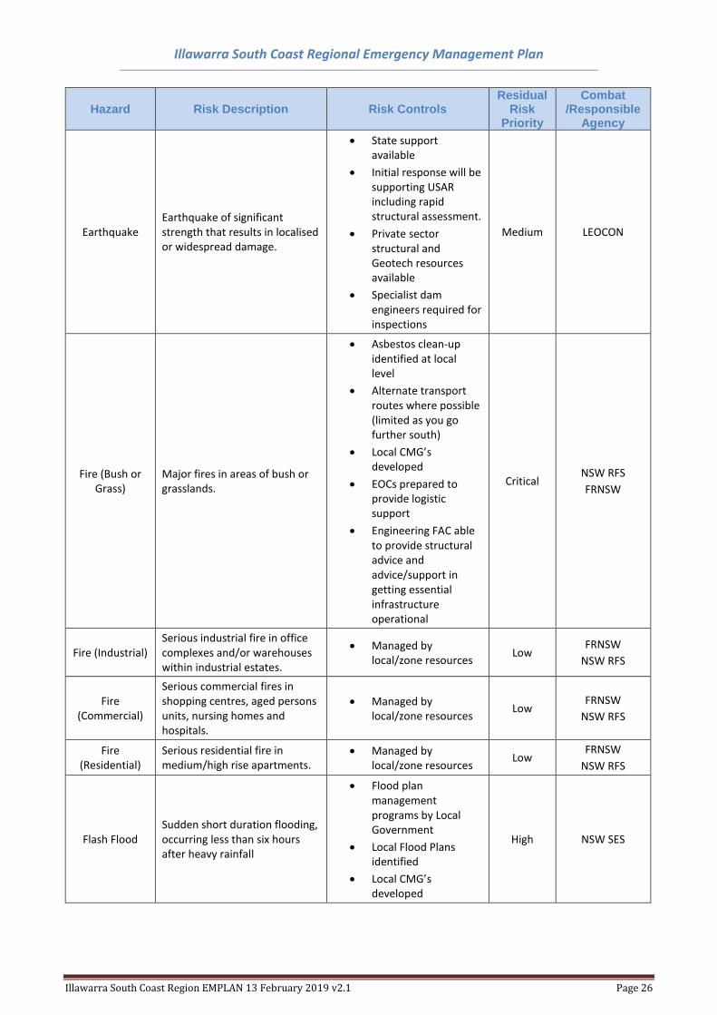
Illawarra South Coast Region EMPLAN 13 February 2019 v2.1 Page 26
Hazard Risk Description Risk Controls Residual
Risk Priority
Combat /Responsible
Agency
Earthquake Earthquake of significant strength that results in localised or widespread damage.
• State support available
• Initial response will be supporting USAR including rapid structural assessment.
• Private sector structural and Geotech resources available
• Specialist dam engineers required for inspections
Medium LEOCON
Fire (Bush or Grass)
Major fires in areas of bush or grasslands.
• Asbestos clean-up identified at local level
• Alternate transport routes where possible (limited as you go further south)
• Local CMG’s developed
• EOCs prepared to provide logistic support
• Engineering FAC able to provide structural advice and advice/support in getting essential infrastructure operational
Critical NSW RFS
FRNSW
Fire (Industrial) Serious industrial fire in office complexes and/or warehouses within industrial estates.
• Managed by local/zone resources
Low FRNSW
NSW RFS
Fire (Commercial)
Serious commercial fires in shopping centres, aged persons units, nursing homes and hospitals.
• Managed by local/zone resources
Low FRNSW
NSW RFS
Fire (Residential)
Serious residential fire in medium/high rise apartments.
• Managed by local/zone resources
Low FRNSW
NSW RFS
Flash Flood Sudden short duration flooding, occurring less than six hours after heavy rainfall
• Flood plan management programs by Local Government
• Local Flood Plans identified
• Local CMG’s developed
High NSW SES
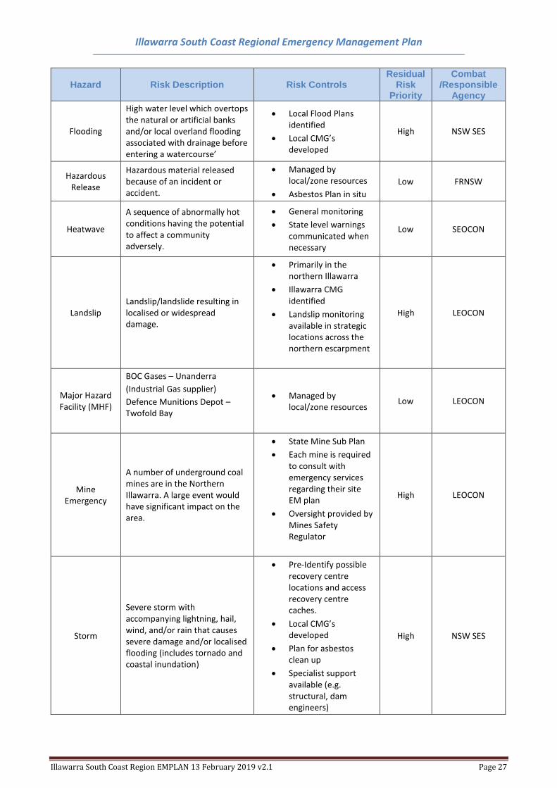
Illawarra South Coast Regional Emergency Management Plan
Illawarra South Coast Region EMPLAN 13 February 2019 v2.1 Page 27
Hazard Risk Description Risk Controls Residual
Risk Priority
Combat /Responsible
Agency
Flooding
High water level which overtops the natural or artificial banks and/or local overland flooding associated with drainage before entering a watercourse’
• Local Flood Plans identified
• Local CMG’s developed
High NSW SES
Hazardous Release
Hazardous material released because of an incident or accident.
• Managed by local/zone resources
• Asbestos Plan in situ
Low FRNSW
Heatwave
A sequence of abnormally hot conditions having the potential to affect a community adversely.
• General monitoring
• State level warnings communicated when necessary
Low SEOCON
Landslip Landslip/landslide resulting in localised or widespread damage.
• Primarily in the northern Illawarra
• Illawarra CMG identified
• Landslip monitoring available in strategic locations across the northern escarpment
High LEOCON
Major Hazard Facility (MHF)
BOC Gases – Unanderra
(Industrial Gas supplier)
Defence Munitions Depot – Twofold Bay
• Managed by local/zone resources
Low LEOCON
Mine Emergency
A number of underground coal mines are in the Northern Illawarra. A large event would have significant impact on the area.
• State Mine Sub Plan
• Each mine is required to consult with emergency services regarding their site EM plan
• Oversight provided by Mines Safety Regulator
High LEOCON
Storm
Severe storm with accompanying lightning, hail, wind, and/or rain that causes severe damage and/or localised flooding (includes tornado and coastal inundation)
• Pre-Identify possible recovery centre locations and access recovery centre caches.
• Local CMG’s developed
• Plan for asbestos clean up
• Specialist support available (e.g. structural, dam engineers)
High NSW SES
Illawarra South Coast Regional Emergency Management Plan
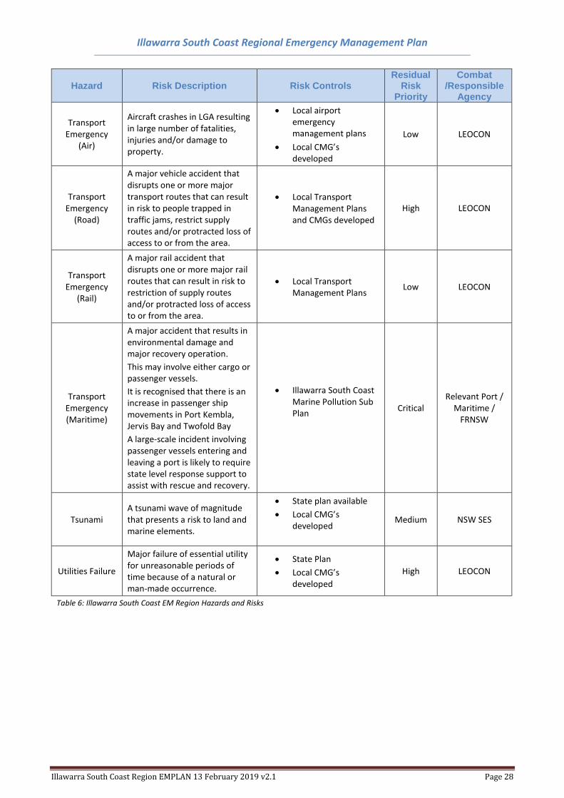
Illawarra South Coast Region EMPLAN 13 February 2019 v2.1 Page 28
Hazard Risk Description Risk Controls Residual
Risk Priority
Combat /Responsible
Agency
Transport Emergency
(Air)
Aircraft crashes in LGA resulting in large number of fatalities, injuries and/or damage to property.
• Local airport emergency management plans
• Local CMG’s developed
Low LEOCON
Transport Emergency
(Road)
A major vehicle accident that disrupts one or more major transport routes that can result in risk to people trapped in traffic jams, restrict supply routes and/or protracted loss of access to or from the area.
• Local Transport Management Plans and CMGs developed
High LEOCON
Transport Emergency
(Rail)
A major rail accident that disrupts one or more major rail routes that can result in risk to restriction of supply routes and/or protracted loss of access to or from the area.
• Local Transport Management Plans
Low LEOCON
Transport Emergency (Maritime)
A major accident that results in environmental damage and major recovery operation.
This may involve either cargo or passenger vessels.
It is recognised that there is an increase in passenger ship movements in Port Kembla, Jervis Bay and Twofold Bay
A large-scale incident involving passenger vessels entering and leaving a port is likely to require state level response support to assist with rescue and recovery.
• Illawarra South Coast Marine Pollution Sub Plan
Critical Relevant Port /
Maritime / FRNSW
Tsunami A tsunami wave of magnitude that presents a risk to land and marine elements.
• State plan available
• Local CMG’s developed
Medium NSW SES
Utilities Failure
Major failure of essential utility for unreasonable periods of time because of a natural or man-made occurrence.
• State Plan
• Local CMG’s developed
High LEOCON
Table 6: Illawarra South Coast EM Region Hazards and Risks
Illawarra South Coast Regional Emergency Management Plan
Illawarra South Coast Region EMPLAN 13 February 2019 v2.1 Page 29
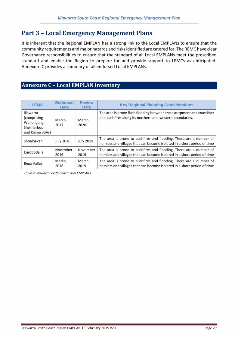
Part 3 – Local Emergency Management Plans
It is inherent that the Regional EMPLAN has a strong link to the Local EMPLANs to ensure that the community requirements and major hazards and risks identified are catered for. The REMC have clear Governance responsibilities to ensure that the standard of all Local EMPLANs meet the prescribed standard and enable the Region to prepare for and provide support to LEMCs as anticipated. Annexure C provides a summary of all endorsed Local EMPLANs.
Annexure C – Local EMPLAN Inventory
LEMC Endorsed
Date Review
Date Key Regional Planning Considerations
Illawarra (comprising Wollongong, Shellharbour and Kiama LGAs)
March 2017
March 2020
The area is prone flash flooding between the escarpment and coastline; and bushfires along its northern and western boundaries.
Shoalhaven July 2016 July 2019 The area is prone to bushfires and flooding. There are a number of hamlets and villages that can become isolated in a short period of time
Eurobodalla November 2016
November 2019
The area is prone to bushfires and flooding. There are a number of hamlets and villages that can become isolated in a short period of time
Bega Valley March 2016
March 2019
The area is prone to bushfires and flooding. There are a number of hamlets and villages that can become isolated in a short period of time
Table 7: Illawarra South Coast Local EMPLANs
Illawarra South Coast Regional Emergency Management Plan
Illawarra South Coast Region EMPLAN 13 February 2019 v2.1 Page 30
Part 4 – Sub Plans and Supporting Plans Responsibility for the preparation and maintenance of appropriate sub and supporting plans rests
with the relevant Combat Agency Controller or the relevant Functional Area Coordinator. They form
a critical element that outlines the arrangements that are in place to deliver support or control at a
Regional and Local level as emergencies arise. There are some specific REMC sub and supporting
plans that have also been developed to assist with delivering the outcomes of this EMPLAN. The
sub/supporting plans are developed in consultation with the Illawarra South Coast REMC and the
community.
The plans listed in Annexure D are supplementary to this EMPLAN. The sub/supporting plans have
been endorsed by the REMC and are determined as compliant and complimentary to the
arrangements listed in this EMPLAN.
These plans are retained by the REMO on behalf of the REMC and public release versions are available
on the NSW Emergency Website.
Illawarra South Coast Regional Emergency Management Plan
Illawarra South Coast Region EMPLAN 13 February 2019 v2.1 Page 31
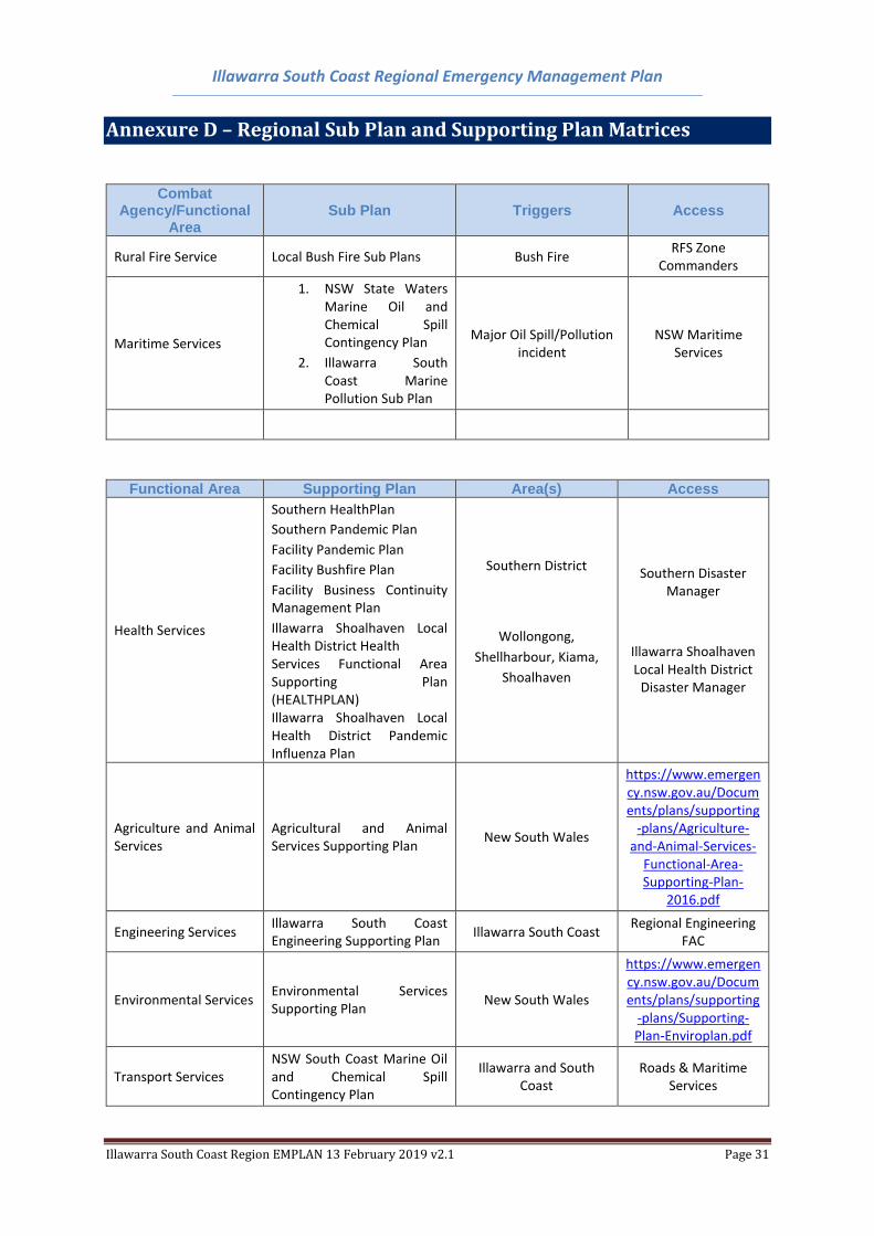
Annexure D – Regional Sub Plan and Supporting Plan Matrices
Combat Agency/Functional
Area Sub Plan Triggers Access
Rural Fire Service Local Bush Fire Sub Plans Bush Fire RFS Zone
Commanders
Maritime Services
1. NSW State Waters Marine Oil and Chemical Spill Contingency Plan
2. Illawarra South Coast Marine Pollution Sub Plan
Major Oil Spill/Pollution incident
NSW Maritime Services
Functional Area Supporting Plan Area(s) Access
Health Services
Southern HealthPlan
Southern Pandemic Plan
Facility Pandemic Plan
Facility Bushfire Plan
Facility Business Continuity Management Plan
Illawarra Shoalhaven Local Health District Health Services Functional Area Supporting Plan (HEALTHPLAN) Illawarra Shoalhaven Local Health District Pandemic Influenza Plan
Southern District
Wollongong,
Shellharbour, Kiama,
Shoalhaven
Southern Disaster Manager
Illawarra Shoalhaven Local Health District
Disaster Manager
Agriculture and Animal Services
Agricultural and Animal Services Supporting Plan
New South Wales
https://www.emergency.nsw.gov.au/Documents/plans/supporting
-plans/Agriculture-and-Animal-Services-
Functional-Area-Supporting-Plan-
2016.pdf
Engineering Services Illawarra South Coast Engineering Supporting Plan
Illawarra South Coast Regional Engineering
FAC
Environmental Services Environmental Services Supporting Plan
New South Wales
https://www.emergency.nsw.gov.au/Documents/plans/supporting
-plans/Supporting-Plan-Enviroplan.pdf
Transport Services NSW South Coast Marine Oil and Chemical Spill Contingency Plan
Illawarra and South Coast
Roads & Maritime Services
Illawarra South Coast Regional Emergency Management Plan
Illawarra South Coast Region EMPLAN 13 February 2019 v2.1 Page 32
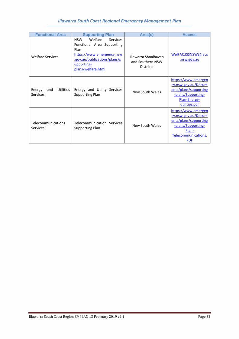
Functional Area Supporting Plan Area(s) Access
Welfare Services
NSW Welfare Services Functional Area Supporting Plan https://www.emergency.nsw.gov.au/publications/plans/supporting-plans/welfare.html
Illawarra Shoalhaven and Southern NSW
Districts
WelFAC.ISSNSW@facs
.nsw.gov.au
Energy and Utilities Services
Energy and Utility Services Supporting Plan
New South Wales
https://www.emergency.nsw.gov.au/Documents/plans/supporting
-plans/Supporting-Plan-Energy-utilities.pdf
Telecommunications Services
Telecommunication Services Supporting Plan
New South Wales
https://www.emergency.nsw.gov.au/Documents/plans/supporting
-plans/Supporting-Plan-
Telecommunications.PDF