ifa paper no. 4 - archaeologists.net · ifa paper no. 4 the maritime archaeological resource...
TRANSCRIPT

The marine archaeological resource
IFA Paper No. 4
Ian Oxley and David O’Regan

IFA PAPER NO. 4 THE MARITIME ARCHAEOLOGICAL RESOURCE
Published by the Institute of Field ArchaeologistsSHES, University of Reading, Whiteknights,PO Box 227, Reading RG6 6AB
ISBN 0 948393 18 1
Copyright © the authors (text), illustrations by permission© IFA (typography and design)
Edited by Jenny Moore and Alison Taylor
The authors
Ian Oxley, formerly Deputy Director of theArchaeological Diving Unit, University of St Andrews,is researching the management of historic wreck sites atthe Centre for Environmental Resource Management,Department of Civil and Offshore Engineering, Heriot-Watt University, Edinburgh.
David O’Regan is a freelance archaeologist, formerlyProject Manager for the Defence of Britain Project,Imperial War Museum.
Acknowledgements
A document attempting to summarise a subject area aswide as UK maritime archaeology inevitably involvesthe input of a large number of people. It is impossibleto name them all and therefore any omissions areregretted but their support is gratefully acknowledged.Particular thanks go to Martin Dean, Mark Lawrence,Ben Ferrari, Antony Firth, Karen Gracie-Langrick, MarkRedknap and Kit Watson. General thanks go to the pastand present staff members of the Archaeological DivingUnit and the Scottish Institute of Maritime Studies atthe University of St Andrews, and officers and Councilmembers of the IFA and its Maritime Affairs SpecialInterest Group.
The IFA gratefully acknowledges the assistance of theRoyal Commission on the Historical Monuments ofEngland, Royal Commission on the Ancient andHistorical Monuments of Scotland, Historic Scotland,and the Environment and Heritage Service, HistoricBuildings and Monuments, DoE(NI), for funding thispaper.

IFA PAPER NO. 4 THE MARITIME ARCHAEOLOGICAL RESOURCE
Integrated marine conservation initiatives
Marine archaeological assessments 14AppraisalSources of archaeological expertiseHealth and Safety requirements and the
contracting of diversCollecting known informationRelative importance of archaeological
underwaterAssessing archaeological potentialGeographical Information Systems
Conservation strategies 16Codes of practiceOpportunities for encouraging accessRespect our WrecksAssessing impactManagement in situAccidental discovery of archaeological
remainsReporting systems for marine findsAvoidanceDesk-based studyWatching briefs
Evaluation techniques 19Position fixingGeophysical surveyVisual search techniquesStill and video camerasMagneticMetal-detectorsSonar-based systemsEcho-sounderSide scan sonarSub-bottom profilerIntrusive investigations
Conclusions 24
Bibliography 25
Appendix 1 Further information and addresses 28
The marine archaeological resource
INSTITUTE OF FIELD ARCHAEOLOGISTS PAPER NO. 4
by Ian Oxley and David O’Regan
Contents
Introduction 2
Background 2Development of maritime archaeology
in the UKCharacter of the marine archaeological resourceVisibility of archaeological material
underwaterEffect of human activities disturbing marine
archaeological environments
Management 5Government departments responsible for
near and offshore areasBoundariesTraditional rightsOwnershipInternational initiatives
Inventories of maritime sites 7National inventoriesLocal inventories
Legislation 8Scheduling or protection of sitesMerchant Shipping Act 1894‘Historic’ wreckProtection of Wrecks Act 1973The Historic Monuments and Archaeological
Objects (NI) Order 1995Ancient Monuments and Archaeological
Areas Act 1979Protection of Military Remains Act 1986
Coastal planning and management 11Planning decisionsCoastal Zone ManagementGovernment View (GV)Environmental AssessmentManagement plans and conservation policiesCoastal management plansEstuary and firth management plansShoreline Management PlansHeritage Coasts
1

THE MARITIME ARCHAEOLOGICAL RESOURCEIFA PAPER NO. 4
2
Introduction
Increasing attention is being paid to the archaeologicalheritage on and beneath the seabed. The aim of this paperis to help familiarise archaeologists with the nature ofthis resource together with its management, protectionand investigation.
Guidance is offered here in order that those archaeologistsmore conversant with the situation on land can be madeaware of the possible methods for approaching andinvestigating marine sites. It is hoped that other individualsand organisations whose activities and responsibilitiesrelate to and affect the marine archaeological resourcewill also benefit where appropriate.
The marine zone of the UK can comprise inshore waters,the inter-tidal zone, river estuaries, and a stretch ofcoastal land influenced by the ocean, which contains anabundant but fragile archaeological resource reflectingthe past use of coastal land and sea. Often these historiclandscapes can extend seamlessly from land, through theinter-tidal zone and into sub-tidal areas. Thus maritimearchaeological resources exist in two different environ-ments; on dry land and underwater. Underwater, maritimeor marine archaeology has a broad meaning, often shiftingand inter-locking within a specific watery environmentand includes a range of sites from shipwrecks and harboursto submerged prehistoric landscapes. Satisfactory andwidely accepted definitions of ‘marine’, ‘maritime’ and‘underwater’ do not exist and often the word ‘maritime’ isused to provide the broadest coverage and inter-relationwith traditional, terrestrial archaeology.
It is essential to consider the ‘interconnectedness’ of evidence in a holistic way across all the environments.Boundaries or distinctions, such as inland, coastal, fore-shore, inter-tidal, and marine, are artificial devices that donot necessarily have any relevance to the present extentof the marine archaeological heritage. In addition, thecurrent limits to the responsibilities of local government(often the mean low water mark) are of historic originand have little to do with actual limits of the archaeologicalresource. The diversity and interrelation of archaeologicalevidence must be recognised as existing as a whole, andany strategy of approach applied to the landscape (andformer landscape or ‘seabed-scape’) must be consideredholistically. For example, anchorages and frequentlytravelled sea lanes can provide a valuable insight into thedevelopment of sea traffic and trade over time and maybe marked simply by a spread of widely dispersed debris.All aspects of the archaeological environment (prehistoricand historic) must be viewed in an integrated waybefore they are considered as independent components.
While the practice of underwater or marine archaeology
employs similar procedures and approaches as on land, itsmanagement differs substantially. Presently no integratedstatutory or development controls exist that are sympa-thetic to the marine archaeological heritage in its entirety.
It must be stressed that although there are clearly differ-ences between the nature of the archaeological resource onland and that under the sea there should be no differencesin the approach to the investigation, protection andmanagement of what are essentially parts of the sameresource. The current variations in treatment and management result from the separate development ofdifferent sectors of the disciplines of archaeology andheritage management. Hopefully, in the near future themanagement of the marine resource will be fully integrated into archaeological management and practiceas a whole.
• • • • •
Background
Marine archaeological environments are especially vulnerable to impacts as their preservation is dependentupon poorly understood (compared to terrestrial environments) biological, physical and chemicalprocesses (see Fig 1). Further information can be foundin Ferrari and Adams (1990), Oxley (1992) and Gregory(1996) and see also Fulford et al (1997).
Figure 1 The effects of burrowing fauna on the submerged marine
archaeological resource: a lobster adjacent to prehistoric timber and
worked flints (Momber 2000) (Gary Momber, Hampshire and Wight
Trust for Maritime Archaeology).

IFA PAPER NO. 4
Although there are many potentially destructive forces,complementary interests can aid in the protection andenhancement of the marine archaeological heritage.There is a growing number of coast edge and inter-tidalarchaeological initiatives that recognise the importance ofsubmerged remains. These concerns (and those of wildlifeand nature conservation, recreation and tourism, industry,commerce) will all benefit from increased co-operationat as early a stage as possible. Moreover, it is importantto accept the legitimate and necessary uses of the sea andthe impossibility of completely eliminating the impacts.
Development of maritime archaeology inthe UK
Maritime archaeology is a relatively new discipline andits general history can be found in texts such as Dean etal (1995), Green (1990), Babits and Van Tilburg (1998) andthe International Journal of Nautical Archaeology. Theuncontrolled digging on wreck sites in the late 1960s andearly 1970s prompted the enactment of the Protection ofWrecks Act 1973 and marked the beginnings of modernmaritime archaeology in the UK (Baldwin 1994). In the1970s licensed excavations took place on designated historic wreck sites to varying standards ranging fromlarge, organised projects culminating in the raising of theremains of the Mary Rose, to small, long-running, amateurexcavations. Most of the latter sites remain essentiallyunpublished. Furthermore, it is arguable that the formerlarge projects are probably unrepeatable due to thechanged economic situation. The approach in the mid tolate 1980s involved less intrusive investigations on a muchsmaller scale, with no intention to recover hull structuresor large numbers of artefacts with their attendant conservation implications (Watson and Gale 1990).
In the 1990s a different philosophy has emerged. Ratherthan excavation being the principal activity with thepublic forming the main audience, now the conservationethic is established with much more pre-disturbance ornon-intrusive survey work taking place. At the same timethere is greater involvement by marine archaeologists inthe development of the discipline and a steady integrationof maritime archaeology into field archaeology as awhole (Oxley 1996, Firth 1997).
An important lobby group, the Joint NauticalArchaeology Policy Committee has published Heritage atsea (JNAPC 1989) and Still at sea (JNAPC 1993). Both documents identified key areas for improvement, suchas the extension of the areas of responsibility of EnglishHeritage and all the Royal Commissions to include territorial waters, as well as stressing the need for betterinformation to be available on the nature and extent ofmarine archaeological heritage to inform planning decisions. An additional important initiative has been
the production of a Code of Practice for Seabed Developers(JNAPC 1995), sponsored by substantial industrial concerns, which promotes early contact between thearchaeological community and developers.
Despite these advances it has proved remarkably difficultto break down commonly held misconceptions such as
• ‘fortunes’ can be made by exploiting ‘treasure’ shipsunder the sea – a mistake which can be soundlyrefuted (Von der Porten 1994)
• the (erroneous) belief that ‘finders-keepers’ appliesunderwater (see below ‘Historic’ wreck)
• that it is somehow brave and courageous to go divingand that anyone who does so deserves to profitfrom what they find
On the positive side we have seen examples of a steady‘creeping down the foreshore into the sea’ of terrestrialarchaeologists. Useful examples of this growing integration include the Langstone Harbour Projectwhich advocates a ‘seamless’ approach to survey onland, in the inter-tidal zone and underwater (Allen et al1993, Allen and Gardiner 2000), the recovery of themedieval Magor Pill boat (Nayling 1998), and thearchaeological audit of the Fal Estuary (Ratcliffe, 1997).
However, amongst the public as a whole, and to a certainextent within the archaeological community, thereremains widespread ignorance of, and misconceptionsabout, archaeology underwater. It is not unusual to confront the view that archaeology cannot be effectivelycarried out underwater. In a sense there still remains atime-lag in this country (in contrast to many parts of theworld) in the integration of submerged archaeology intofield archaeology in general. For example, in parts ofmainland Europe an increasing number of examples of theroutine application of scientific archaeological techniquesto material derived from marine or nautical archaeologicalprojects can be found (Robinson and Aaby 1994). Suchprojects are not regarded as exotic or fundamentally different from land archaeology in any way.
Another contentious area is the steadily opening up ofpreviously inaccessible areas of the seabed to those withthe technology and funds to reach them. These deep-seaenvironments, normally in international waters, arelargely unregulated (see International initiatives below)and many issues of ownership, appropriate behaviourand environmental responsibility arise (Goodheart1999). However, important archaeological research isalso being carried out in such challenging environments(Ballard et al 2000).
Other current trends include a steady growth in devel-opment-led maritime and coastal archaeology which, aswell as hopefully coping with the increasing exploitation
3
THE MARITIME ARCHAEOLOGICAL RESOURCE

THE MARITIME ARCHAEOLOGICAL RESOURCE
of inter-tidal and marine zones, is also contributing toour overall understanding of the archaeological potentialof such areas (Firth 2000).
Character of the marine archaeological resource
The relative levels of land and sea have not been static inthe past, and they are changing even today. During theIce Ages, the sea level was lowered by as much as 140m,as thousands of millions of litres of water became lockedup as ice. As a result many new lands were opened up thatdo not exist today. Once the sea levels rose again, evidenceof human activity was submerged and preserved under theadvancing waters (Coles 2000). Sites, which are now ininter-tidal areas or underwater, may once have beenmany miles from the sea. In the past people lived in valleys which have now become estuaries and on hillswhich now form shallow areas of seabed. Evidence offormer human activity can be direct, in the form of arte-facts or structures, or indirect as information recoveredfrom palaeo-environmental deposits (Fulford et al 1997).
The character of the marine resource includes singleartefacts, inundated earthworks and midden sites, aswell as shipwrecks, ancient harbours and submergedvillages, with an age range stretching from prehistorichunter-gatherer sites, to historic towns of the sixteenthand seventeenth century, through to modern times.Archaeological evidence also includes palaeoenvironments(submerged landscapes and/or sedimentary contextscontaining environmental evidence) to a coastal zoneaffected by harbour, waterfront and coastal engineeringworks (Tomalin 1998, Momber 2000). Other remainsinclude jetties, slipways, breakwaters, and evidence ofmaintained channels. Information can also be found ofactivities, which straddled the shoreline such as fishtraps, weirs and saltworks. Most importantly, underwatersites have implications beyond the water environmentinto social, technological and environmental factors bothon land and at sea (Heritage Coast Forum 1993).Continuing sea level changes, land subsidence, erosionand human error claim more areas of former humanoccupation and activity every year. An example of thedynamic nature of the marine environment and thepotential for major impacts is the wrecking of the tankerBraer in Shetland waters in 1993.
In common with terrestrial environments there will be veryfew areas of the seabed or coastal zone that have not beenaffected by human activities. Coastlines, river courses andharbour works are direct signs of modification, whereasparticular coastal habitats and sedimentation patternsalso result from present-day and earlier human alterationof the environment. As such there will be numerousways in which evidence of the past can be gained from
study of marine and underwater environments not leastbecause preservation of archaeological materials in theseenvironments is generally better than on most terrestrialsites (Coles 1987).
Visibility of archaeological material underwater
As on land the visibility of archaeological material onthe seabed varies from immediately recognisable struc-tures to imperceptible ‘humps and bumps’, possibly ofarchaeological interest, to invisible remains buried deepbeneath the seabed. A significant factor which is less frequently encountered on land is the mobile nature ofthe sedimentary materials (sands, silts and muds) whichcover much of the seabed. Currents, waves and tidesalter the structure of the seabed, moving sediment fromone position to another. Often such movement may becyclical with significant amounts of material beingmoved, perhaps during a storm, then replaced throughnatural sedimentation during later calmer periods.
Such seabed movement may simply bury and exposearchaeological materials making them visible during onetime of year and invisible at another. In contrast, in manyareas of the marine environment, particularly estuaries,archaeological remains permanently lie deeply buried andare not obvious from the surface of the sea or the seabed.
Effect of human activities disturbing marinearchaeological environments
The marine environment is comprised of seawater andsediment moved by waves, currents and tides. The com-bination of seawater and sediment provides excellentburial environments for the preservation of archaeologicalmaterial. These marine environments exist because of theinteraction of many factors. Archaeological material
IFA PAPER NO. 4
4
Background to the marine archaeological resource: summary
• Level of awareness – Widespread ignorance of the range,extent, vulnerability, significance and potential of themarine archaeological resource.
• Character – Single, isolated finds to structures ranging fromjetties to harbours; shipwrecks, palaeo-environmentaldeposits.
• Visibility – Essentially hidden to the majority of the population because it is submerged.
• Threats – A wide range of impacts (of both natural andhuman origin) threaten the existence and integrity of themarine archaeological resource.

IFA PAPER NO. 4
5
remains are preserved because of the fragile balance of acomplex variety of chemical, physical and biologicalprocesses which combine to produce specific environ-mental characteristics in particular areas. Continuedpreservation of archaeological remains depends on theenvironment staying in relative equilibrium. Upsettingthe balance, including the simple exposure of previouslyburied archaeological remains, can have a catastrophiceffect (Martin 1995).
There are few spheres of human activity which do not,even indirectly, change or impact the natural environment.Human activities at the coast and on the seabed mayinterrupt currents and tidal systems and their accompa-nying natural sediment regimes, resulting in significantalteration to marine environments. Table 1 illustrates therange of activities in relation to the development process(extraction etc) and zone (inland, coastal, marine).
In general, coast defence structures reduce coastal erosionthrough the construction of walls and other fabrications,or promote accretion of sediments on the coast by ‘trap’mechanisms. Such devices reduce sediment load withinthe water column and so areas down-current may sufferincreased erosion. Offshore areas may also be deprivedof sediments essential for the maintenance of marineenvironments, eg sandbars. Piers, wharves and break-waters may have a similar effect.
Marine aggregate dredging involves the removal oflarge amounts of sand and gravel from offshore areas,often involving millions of tons annually. Such processesinevitably alter marine environments with an, as yet,unquantified effect on archaeological material. Impacts(that can also occur at significant distances from the original development) may be:
• physical, causing the exposure of artefacts andstructures,
• chemical, due to changes in the nature of the environment,
• biological, altering the balance of fouling organismswhich colonise upstanding features on the seabed.
Such phenomena may also occur at significant distancesfrom the original development.
Trawling, which involves dragging large, heavy gear overthe seabed, often results in the penetration of the seabedsurface and will consequently damage archaeologicalmaterial located on or near the sediment surface. It isfairly common for archaeological material to be found intrawl nets (Tomalin 1998).
• • • • •
Management
The current planning and management framework ofthe coastal and marine zones is characterised by thenumber of organisations with powers or responsibilities(NCEAG 1993).
The complexities of the management of coastal and off-shore areas are such that it would be impossible to presenta full picture within the confines of this paper. A reviewof coastal management and the division of powers andresponsibilities among the many bodies is given inCoastal Planning and Management: a Review (Departmentof the Environment 1993); Firth (1993). Fulford et al (1997)describe submerged archaeological remains and theirplace in the management of the coast and offshore areas.Presented below is a brief introduction to some of theresponsibilities of a number of authorities at the coast.
The Department for Culture, Media and Sport (DCMS)takes responsibility for maritime archaeology in Englandbut limits its involvement to hosting the management ofthe Protection of Wrecks Act, 1973 (see below). In Scotlandand Wales the respective heritage organisations, Historic
THE MARITIME ARCHAEOLOGICAL RESOURCE
I N L A N D C O A S TA L M A R I N E
Extraction Alterations to Maintenance Aggregate water courses dredging extraction
Construction Bridges Marinas, Offshore fish farms, installationsport facilities
Linear Cable-laying Outfalls Pipelines, developments trenching
Shoreline Embankments Coastal defences
Diffuse Boat wash Anchoring, Trawling, activities recreational dumping,
diving commercial salvage
Organisations involved in the management of the maritime zone: summary
• landowners
• port and harbour authorities
• Crown Estate Commissioners
• regional water companies
• Environment Agency
• over twenty government departments and agencies
• county, district and metropolitan local authorities
Table 1 Range of development activities in relation to the process
and zone (Firth 1993)

THE MARITIME ARCHAEOLOGICAL RESOURCE
Scotland and Cadw, take responsibility for all submergedremains. Likewise the Environment and HeritageService, an executive agency within the Department of Environment (NI), undertakes responsibility for submerged archaeology in Northern Ireland waters.
Therefore, an anomalous situation remains in Englishwaters where no organisation has primary responsibilityfor archaeology below the mean low water mark. Thisunfortunate accident of history, which has its origins in the original restricted remit of English Heritage, isbeing addressed (English Heritage 1999) and primarylegislation is currently (2001) going through Parliamentto give English Heritage front-line responsibility for the management of marine archaeology in England’s waters.
Government departments responsible for near and offshore areas
The Department of the Environment, Transport and theRegions (DETR) has responsibility for designating MarineNature Reserves and Special Protection Areas (for birdhabitat preservation). It also co-ordinates the Governmentview procedure that are used to determine whethermarine aggregate exploitation can take place below themean low water mark (see below, Government View)and oil and gas extraction. The DETR administers theprovisions of the Merchant Shipping Act 1894 whichapplies to ownership, salvage and the reporting of mate-rial removed from the seabed in UK territorial waters(see ‘Ownership of Wreck’ below). The Department ofTrade and Industry has responsibility for the licensing ofoil and gas exploration, appraisal and development.Such licensing includes requirements for EnvironmentalAssessments and relates to the archaeological resources.
The jurisdiction of local planning authorities usuallyends at the mean low-water mark. However, localauthorities do have control over inland waters and someareas below the low-water mark (eg estuaries andenclosed bodies of water such as harbours) as if theywere land under the planning system (see Firth 1993).
The Crown Estates Commissioners (CEC) are responsiblefor not only maintaining but also enhancing the value ofthe Crown Estate, which includes the seabed out to the12 nautical mile territorial limit, having regard torequirements of good management. The CEC’s role inthe maritime aggregate industry is restricted to issuinglicences to operators, following a favourableGovernment view. In addition, along with the DoE, it isresponsible for determining the need for EnvironmentalAssessments in advance of development proposals.
Local authorities or private companies may control theharbour authorities. Their powers may extend below the
low-water mark and include many by-laws to controlmovement of vessels, fishing and navigation within har-bour waters. In executing their responsibilities harbourauthorities must take into consideration the maintenanceof the natural and built environment which may includearchaeological material.
The Environment Agency, a non-departmental publicbody sponsored by the DETR, has a wide range ofresponsibilities in the coastal zone of England and Walesincluding supervision of all matters relating to flooddefence. The Agency actively considers archaeologicalimplications in the carrying out of its duties and isresponsible for conserving archaeological features andbuildings of historic interest on land that it owns. TheScottish Environment Protection Agency is responsiblefor the protection of the environment in Scotland.
Boundaries
Legal jurisdiction overlaps in the inter-tidal area as meanlow water is often used to define the seaward extent ofland, and high water can mark the landward extent of thesea. Problems of jurisdiction may arise in areas such aspoorly surveyed shelving beaches or large tidal rangesbecause boundaries are based on average, rather thanextreme tides (Firth 1993). Boundaries are often designatedin terms of changes in environment such as wet or dry,depth, extent of climatic influence. The ‘coastal’ zone hasbeen defined as the area from high water to a pointinland where there is no longer a direct relationship withthe sea (be it marine activity or threat of erosion); ‘inter-tidal’ is the area between high-water and low-watermarks and ‘sub-tidal’ means the area from low water tothe boundary of territorial waters (12 nautical miles).
Traditional rights
There are strong traditional rights covering many uses ofthe sea such as fishing, navigation, bait-digging, cocklingand freedom of access. Unless these rights have beenremoved by legislation, they can only be regulatedthrough by-laws confirmed by the appropriate Secretaryof State. Consequently the existence of traditional rightsis an important consideration in achieving conservationobjectives in the coastal zone.
Ownership
Ownership of material lost at sea rests with the originalowners unless it can be shown that it has been abandoned(see below Merchant Shipping Act 1995). In terms ofownership of the seabed about half of the UK foreshoreand almost the entire seabed out to the UK territorial
6
IFA PAPER NO. 4

IFA PAPER NO. 4
limit is managed by the Crown and rights to the mineralresources are administered by the Crown Estates.Numerous wrecks still have current owners. Either ownership resides in the Crown, as in ships that were ingovernment service prior to their loss or rights havebeen acquired by successive institutions (eg insurancecompanies) or individuals. The State maintains rights ofownership over some historic wrecks through the MoDbut the State does not assume ownership of archaeologicalremains underwater. The discovery of a wreck, or anyother archaeological material, does not have to bereported by law unless it is raised from the seabed andbrought ashore, when the Merchant Shipping Act of1995 would apply.
International initiatives
A draft Convention on the Protection of the UnderwaterCultural Heritage is currently under developmentthrough UNESCO (Srong 1999). The aim is to clarify andaddress inconsistencies in the treatment of the culturalheritage in the various marine zones ie internal waters,territorial seas, Exclusive Economic Zones, continentalshelf, and the seabed beneath the high seas. Contentiousissues include the rights and responsibilities of coastalstates, the laws of salvage and the rights of ownership,and the management of the cultural heritage in deep,international waters.
Another important initiative (which is included in thedraft UN Convention as an annex) is the Charter on theProtection and Management of Underwater Cultural Heritagedeveloped by the International Council for Monumentsand Sites (ICOMOS 1998). The Charter covers matters suchas archaeological research design, funding, the scientificobjectives, methodology and techniques of investigation,qualifications of the researchers, collaboration, safety,reporting and deposition of archives.
Other developments in the international context includerecommendations for the acquisition policy for theInternational Congress of Maritime Museums to limit themarket and trade in objects recovered in an unacceptablemanner and suggestions for underwater sites (includingshipwrecks) which may be eligible for World HeritageListing (Henderson 1994).
• • • • •
Inventories of maritime sites
A number of counties and regions in the UK (and otherplanning authorities that operate on a regional basis,National Parks) maintain up-to-date Maritime Sites andMonuments Records (MSMRs) often as a part of theestablished Sites and Monuments Records (SMR). Byhaving as complete a record as possible of such sites it ispossible to make informed archaeological managementdecisions when reviewing development proposals.
National inventories
English Heritage (EH) and revised Royal Warrants of theRoyal Commission on the Ancient and HistoricalMonuments in Scotland (RCAHMS), and RoyalCommission on the Ancient and Historical Monuments inWales (RCAHMW), confirm the extension of their respon-sibilities to include ancient and historical monumentsand constructions in, on or under the seabed within the UKterritorial sea adjacent to England, Wales and Scotland.The Environment and Heritage Service (EHS) has takenon equivalent responsibilities for Northern Ireland
English Heritage, RCAHMS and RCAHMW have eachestablished a Maritime Record, which forms part of theNational Monuments Record (NMR), providing aninventory of maritime sites including shipwrecks andareas of archaeological importance within a coastal limitof twelve nautical miles and with a cut-off date of 1945.Northern Ireland has a well-established SMR for recordingsites on land but before 1993 had no equivalent recordfor maritime sites. To provide a record of maritime sitethe EHS set up the Maritime Archaeology Project (MAP)in October of 1993 that aims to create a database of allunderwater archaeological sites in Northern Ireland’scoastal waters (Breen 1996).
Local inventories
Maritime SMRs have been established in some Englishcounties and at least two Scottish regions (Fife and
7
THE MARITIME ARCHAEOLOGICAL RESOURCE
Management of the marine archaeological resource: summary
• A large number of organisations are involved in the planningand management framework of marine archaeology
• Many Government Departments have responsibilities inmarine areas and activities
• Many interests and activities have different administrativeboundaries such as the low water mark or 12 nautical milesfrom shore
• Numerous traditional rights exist such as freedom of navigation or access
• Ownership of objects found in the sea rests with the originalowners unless it has been abandoned
• Initiatives are increasingly required to be integrated on aEuropean or International basis.

THE MARITIME ARCHAEOLOGICAL RESOURCE
Highland). These records aim to complement the landrecords and provide a more complete inventory of thearchaeological resources of the area concerned. However,local SMRs should not be considered a complete recordof submerged sites at this time.
Other individual projects have enhanced the records forspecific areas. Cleveland County Council, NorthYorkshire County Council, and North York MoorsNational Park recently completed a study, funded by theRCHME (now EH), of a section of coast stretching fromSeaham (County Durham) to Whitby (North Yorkshire).The objectives of the project were to:
• identify and access sources of data at a local level • enhance data in the SMRs and EH’s Maritime
Record• contribute towards the development of compilation
and enchancement methodologies of inventories inthe marine zone
• raise the awareness of marine archaeology in thenortheast
The project identified 2243 potential archaeological sitesand contacted 194 individuals and organisations. It alsosignificantly increased public awareness of the local sub-merged archaeological resource (Buglass 1994).
The Maritime Fife project (funded by Fife Council,Historic Scotland and RCAHMS) has significantlyenhanced the Fife SMR and Scotland’s NMRS. This hasbeen achieved by carrying out archaeological audits ofthe coast edge and inter-tidal zones, and compilingrecords of shipwrecks situated in Fife’s coastal waters(Oxley 2001).
• • • • •
Legislation
Scheduling or protection of sites
Archaeological sites of any type underwater in the UKare not protected unless there has been a specific legalorder of protection. Although there are relatively fewpieces of legislation with direct relevance to archaeologyunderwater, their interrelationships are often complex,misunderstood and subject to variations in interpretation.Separate legislation is currently applied to shipwrecksites thought to be of significance and there is no provision for the comprehensive portable antiquitieslegislation that has equal application regardless of theenvironment in which the find was made.
Recognising the inconsistencies in the current situationthe Joint Nautical Archaeology Policy Committee haspublished a set of proposals for legislative change aimedat securing the protection of the underwater culturalheritage (JNAPC 2000a). A summary of the applicationand implications of various pieces of legislation appliedto the submerged cultural resource follows.
Merchant Shipping Act 1995
‘Wreck’ recovered from the sea and other tidal waters(including material of archaeological and historic value)is subject to the provisions of the Merchant Shipping Act1995 (Receiver of Wreck 1994). ‘Wreck’ includes a ship,aircraft, or hovercraft, parts of these, their cargo andequipment. The Receiver of Wreck, located within theMaritime and Coastguard Agency, is responsible for theadministration of the Act on the behalf of theDepartment of Transport, Environment and the Regions.All recovered material must be reported to the Receiverwho will then determine if it can be considered as wreckor not. This requirement includes material recoveredfrom sites designated under the Protection of Wreck Act1973 (see below). The Receiver will investigate owner-ship of wreck items and the owner has one year to comeforward and prove title to the property. During thisstatutory period the finder may be allowed to hold thematerial on behalf of the Receiver. The Receiver must besatisfied that the finder has sufficient expertise andresources to provide adequate conservation treatment toensure that the material does not deteriorate.
‘Historic’ wreck
Parts of the Merchant Shipping Act were designedspecifically to control problems relating to the salvage ofcommercial material and to protect the rights of ownerswhose property was lost at sea or wrecked on the coastof the UK.
The system still requires that items be raised from theseabed. In the past this has served to encourage uncontrolled disturbance of burial environments of sites.The obligation to report to the Receiver comes as arequirement of salvage, as all objects recovered from thesea had an owner when they were lost. If nothing isrecovered there is no requirement to report the locationof the wreck. Thus the Act does not provide for thereporting of archaeological remains per se, nor for theirpreservation in situ, and it does not cover inland waters.
Wreck recovered from within UK waters which remainsunclaimed at the end of the one-year statutory period,becomes the property of the Crown and the Receiver ofWreck is required to dispose of it. This may be through
8
IFA PAPER NO. 4

IFA PAPER NO. 4
sale or auction, although in many instances the finderwill be allowed to keep items of unclaimed wreck inplace of a salvage award. The latter is normally the marketvalue of the object. The Receiver of Wreck is committedto try, wherever practical, to offer items of historic wreckto institutions where they will remain accessible to thepublic (eg registered museums).
New reporting systems for marine finds developed on alocal or regional basis should include notifying theReceiver of finds so that all legal requirements are complied with. This should also help to engender goodcommunication links between the Receiver and the localarchaeological expertise (Allen 1995).
Protection of Wrecks Act 1973
The Protection of Wrecks Act 1973 is administered by theSecretary of State for Department for Culture, Media andSport (DCMS), but advice is supplied by the Home Countryheritage bodies on designations in those countries.
Under this Act wreck sites of archaeological, historical orartistic interest are designated and a restricted areaaround the wreck established where activities such asdiving, excavation, deposition of materials, and salvageare prohibited, except where a licence is issued (withappropriate restrictions) by the DCMS, Historic Scotlandor Cadw. Advice on designation is provided by theAdvisory Committee on Historic Wreck Sites (ACHWS),a non-governmental body composed of individuals with interests and expertise in the marine zone. DCMSprovides secretarial support to the ACHWS, who onlyadvise on application presented to them and thereforesites which merit protection may not necessarily come tothe attention of the Committee.
Technical support for the implementation of the Act iscurrently provided under contract to the DCMS by theArchaeological Diving Unit (ADU) based in theUniversity of St Andrews (see below Appendix 1). Thefunctions of the ADU include:
• The investigation and assessment of new sites proposed for designation under the Act
• The monitoring of survey and excavation work
carried out under license on existing designated sites• Advising existing licensees and advising
archaeologists• The assessment of threats (human and natural) to
existing designated sites
Once designated an entry is published in Notices toMariners (marine advice notes produced regularly by theHydrographic Office) and the designated area is markedon Admiralty charts (subject to periodic revision). Somesites, situated close to shore, have notices warning of therestricted area placed nearby. Offshore sites may bemarked with an historic wreck buoy.
There is no specific age limit for designating a wreck norany reference in the Act to ‘national’ importance but thesites must be located within the 12 mile territorial limitand in tidal waters. Currently most of the designatedwrecks are post-medieval with the majority located inthe south and southwest of England. There are at present49 designated historic wreck sites (see Fig 2 and Table 2),six in Scotland, five in Wales, 37 in England and one inNorthern Ireland. This distribution reflects historicallyfavoured areas for sport diving rather more than maritimeactivity in the past.
The discovery of any new wreck sites should always bereported to the DCMS, Historic Scotland, Cadw or theEnvironment and Heritage Service depending upon itslocation or to the ADU, so that appropriate action can betaken to assess whether the site is of archaeological, historic or artistic significance. The information shouldalso be sent to the relevant local SMR and national monuments inventory.
Further information about the location of designated historic wreck sites and the forms required for applicationsto survey, excavate or designate new sites under the Actcan be obtained from the organisations listed above (seebelow Appendix 1). A guide to the designated historicwreck sites is published by the ADU on the World WideWeb URL http://www.st-and.ac.uk/institutes/sims/Adu/deswreck.html (Archaeological Diving Unit 1998).Advice for prospective licensees and archaeologicaladvisors (Dean et al 2000) can also be downloaded fromhttp://www.adu.org.uk.
The Historic Monuments and Archaeological Objects (NI) Order 1995
This order extends legal protection to archaeologicalsites and objects below the high-water mark and on theseabed. Under this legislation, sites can be scheduled onland and the seabed to 12 nautical miles offshore. Anumber of sites in the inter-tidal zone in StrangfordLough have recently been scheduled under this order.
9
THE MARITIME ARCHAEOLOGICAL RESOURCE
Reporting of maritime finds: summary
• inform Receiver of Wreck
• notify National Monuments Record
• notify local Sites and Monuments Record
• notify local archaeologist

THE MARITIME ARCHAEOLOGICAL RESOURCE
Ancient Monuments and Archaeological Areas Act 1979
The Ancient Monuments and Archaeological Areas Act1979 can be applied within UK territorial waters as itcontains a general provision for the scheduling of mon-uments in the territorial sea and it also refers specificallyto vessels. The only wholly submerged sites to have beenscheduled in the UK (protected as recently as May 2001)are the seven remaining warships from the German HighSeas Fleet scuttled in Scapa Flow after WWI. As part oftheir published policy to treat submerged remains in thesame way as terrestrial archaeology (Historic Scotland1999), Historic Scotland have chosen to use the 1979 Actin this case because of the need to maintain and encouragea high level of appropriate access to the sites by therecreational diving community.
Protection of Military Remains Act 1986
The Protection of Military Remains Act 1986 provides forthe protection of the remains of military aircraft and vesselsthat have crashed, sunk or been stranded and this includesany associated human remains. Wreckage of ships haveto be designated as a ‘protected place’ or as a ‘controlledsite’ by the Secretary of State for Defence. Once designatedit is an offence to tamper with, damage, move, remove,unearth or enter such remains. Divers are allowed to visitsuch sites provided that no damage results. Howeverthere are many problems with the 1986 Act and its relationto archaeological and historical remains (Dromgoole1996). In any event no sites have been designated andthere has been recent widespread expression of concernabout the behaviour of some recreational divers on somemilitary wreck sites, particularly those which involvedthe loss of life, the so-called ‘war graves’. In response toquestions raised in the House of Lords in November2000, the Parliamentary Under-Secretary for State, MoD,responded by noting the concerns, stating that the MoDis to undertake a review of its policy on military sites.
10
IFA PAPER NO. 4
Table 2 List illustrating the type of site designated under the
Protection of Wrecks Act 1973. The site numbers refer to the
locations shown on Figure 2 (Archaeological Diving Unit,
University of St Andrews)
Site Name Date (AD Description LocationNo except where shown)
1 Cattewater 1500–1550 armed merchantman Plymouth
2 Mary Rose 1545 warship Portsmouth
3 Grace Dieu 1439 warship Hamble River
4 Amsterdam 1739 Dutch East Indiaman Hastings
5 Mary 1675 Royal yacht Anglesey
6 Assurance/Pomone 1738 warships Isle of Wight
7 Anne 1690 warship Rye Bay
8 Tearing Ledge 1707 warship Isles of Scilly
9 Rill Cove 1616? armed merchantman? Lizard, Cornwall
10 South Edinburgh late c 1700s merchantman Thames Estuary
Channel
11 Church Rocks c 1500s? warship? Teignmouth
12 Pwll Fanog Late Med. slate carrier Menaii Strait
13 Moor Sand c 1000 BC artefact scatter Prawle Point
14 Coronation 1690 warship Rame Head
(Offshore)
15 Kennemerland 1664 Dutch East Indiaman Shetland
16 Langdon Bay c 1100 BC artefact scatter Dover
17 Tal-y-bont 1600–1650? armed merchantman? Barmouth
18 Stirling Castle 1703 warship Goodwin Sands
19 Invincible 1758 warship Solent
20 Bartholomew Ledges c 1500s armed merchantman Isles of Scilly
21 Northumberland 1703 warship Goodwin Sands
22 Restoration 1703 warship Goodwin Sands
23 St Anthony 1527 merchantman Lizard
24 Schiedam 1684 merchantman Lizard
25 Brighton Marina c 1600s warship? Brighton
26 Yarmouth Roads c 1600 armed merchantman? Isle of Wight
27 Studland Bay c 1500 armed merchantman? Poole
28 Admiral Gardner 1809 English East Indiaman Goodwin Sands
29 Hazardous 1706 warship W. Sussex
30 Coronation (Inshore) 1690 warship Rame Head
31 Iona II 1864 paddle steamer Isle of Lundy
32 Gull Rock c 1400/1500s artefact scatter Isle of Lundy
33 Wrangels Palais 1687 Danish warship Shetland
34 Erme Estuary c 1500/1700s? artefact scatter S. Devon
35 The Smalls c 1100 isolated findspot W. Wales
36 Duart Point 1653 warship Sound of Mull
37 Dartmouth 1690 warship Sound of Mull
38 Girona 1588 warship N. Ireland
39 Royal Anne 1721 warship Lizard, Cornwall
40 Erme Ingot site multi-period? artefact scatter S. Devon
41 Dunwich Bank c 1600s warship Suffolk
42 Resurgam 1880 submarine N. Wales
43 Hanover 1763 PO packet Cornwall
44 Seaton Carew c 1800s collier brig Teesside
45 Cannon site c 1600s artefact scatter Devon
46 A1 c 1900s submarine Solent
47 Burntisland c 1600s ferry Firth of Forth
48 Loe Bar c 1600s English East Indiaman Lizard
49 Mingary c 17th warship Ardnamurchan
50 Kinlochbervie c. 16th merchantman/warship Kinlochbervie
Inventories and legislation: summary
• Increasingly national and local SMRs are including records
of maritime and marine archaeological sites
• Underwater sites are not automatically protected
• There are many inconsistencies between the relevant Acts of
Parliament relating to the submerged heritage
• All recoveries of objects from the sea must be reported to
the Receiver of Wreck
• The Protection of Wrecks Act, 1973, is used to control
activities in areas of seabed containing wrecks of historic,
artistic or archaeological interest

IFA PAPER NO. 4
Coastal planning and management
Development control and development plans are widelyused to protect specific sites and larger areas but they aremainly aimed at terrestrial archaeological resources.However, in recent years a number of initiatives, oftenco-ordinated by local authorities and partly sponsoredby national heritage organisations, have focused on discrete areas of the coast such as the Fal Estuary(Ratcliffe 1997), Plymouth (Firth et al 1997) andFlamborough Head (FHSMAP 1998).
Planning decisions
In England, government policy on archaeology anddevelopment on land is set out in Planning PolicyGuidance Note 16 (PPG 16): Archaeology and Planning(Department of the Environment 1990). In Scotland,National Planning Policy Guideline (NPPG 5): Archaeologyand Planning (Scottish Office Environment Department1994) provides guidance on archaeology. In Wales theequivalent is provided by Welsh Office circular 60/96.Similar guidance is being considered for NorthernIreland. Archaeological sites are viewed as being a finiteresource that must not be needlessly destroyed and wherethreatened by development a presumption in favour of their physical preservation should be made. Theseprinciples can be applied equally in marine environmentsbut this is not specified in the planning guidance.
Additional guidance notes have implications for sub-merged archaeological material. In England, PlanningPolicy Guidance Note 15 (PPG 15): Planning and the Historic
Environment, provides guidance on the protectionof the historic landscape and deals brieflywith the question of sustainability(Department of the Environment 1994).Planning Policy Guidance Note 20 (PPG 20):Coastal Planning is concerned with planningat the coast and makes specific referenceto the historic landscapes associated withthe coast, noting that the coastal zone hasa rich cultural heritage both above andbelow the low-water mark (Departmentof the Environment 1992). Although thejurisdiction of planning authoritiesextends only to the mean low water mark,it is recognised that onshore developmentsmay have impacts beyond that limit andthat these should be taken into account.
Similarly, additional guidance notes have implications forsubmerged archaeological material in Scotland. NPPG 13:Coastal Planning, (as with PPG 20), is concerned with
11
THE MARITIME ARCHAEOLOGICAL RESOURCE
Figure 2 The location of the 49
current historic wreck sites in United
Kingdom waters designated under the
Protection of Wrecks Act 1973.
The shaded area indicates the extent
of the 12 nautical mile territorial
limit (Archaeological Diving Unit,
University of St Andrews)

THE MARITIME ARCHAEOLOGICAL RESOURCE
planning at the coast and sustainable development. Itidentifies cultural heritage as a resource to be consideredin planning and includes ‘…scheduled monuments andother archaeological sites and landscapes, listed buildings,conservation areas and historic gardens and designedlandscapes, as well as surviving archaeological remainsboth on land and below low water mark’ (Scottish OfficeDevelopment Department 1997). It emphasises thatplanning authorities should recognise the interrelation-ship of land and sea and between onshore and offshoreactivities.
Coastal Zone Management
Coastal Zone Management (CZM) achieved nationalattention with the publication in March 1992 of the Houseof Commons Environment Committee’s report on CoastalZone Protection and Planning. The committee reachedsome fifty conclusions and made recommendationsincluding the creation of a National Coastal Zone Unit,the formation of regional CZM groups, the developmentof a hierarchy of CZM Plans from national to local levelsand the harmonisation of land and seaward planningcontrols to the 12-mile limit of territorial waters.However, the subordinate position of archaeology inCZM is apparent. Of the eighty plus submissions to thecommittee, none of them were principally concernedwith archaeology (Firth 1995).
In the Coastal Zone Protection and Planning (Department ofthe Environment 1992) report the government stated it wasnot persuaded that extension of local planning controlsseaward was necessarily the best approach, nor did itaccept the suggestions for a National Coastal Zone Units,regional groups or a hierarchy of CZM plans. Instead,the government proposed that local authorities take thelead in preparing management plans and liaison withlocal bodies. Further, the government identified thedamage to archaeological interests in the coastal zone as animportant theme for management plans. The governmentalso accepted the need for a consistent approach to theapplication of consent procedures to marine industriesand improved application of Environmental Assessmentprocedures in coastal areas, raising the possibility of archaeological assessments in advance of marinedevelopments.
Despite these sentiments it is clear that a strategic visionfor the future coast is lacking and the UK governmentand the devolved administrations are under pressure toput forward new proposals. The European Commissionhas recently published guidance on Integrated CoastalZone Management (ICZM) (Commission of the EuropeanCommunities 2000). Member States need to developnational strategies to implement the following principlesof ICZM:
• A broad ‘holistic’ perspective (thematic and geographic).
• A long term perspective.• Adaptive management during a gradual (planning
and management) process.• Reflect local specificity.• Work with natural processes.• Participatory planning.• Support and involvement of all relevant
administrative bodies.• Use of a combination of instruments.
The national strategy should:
• Define the relative roles of the different administrative actors ensuring both adequate localcontrol, and also sufficient regional vision and consistency.
• Develop the means of bridging the land-sea interface in terms of national legislation, policiesand programmes.
• Identify measures to promote bottom-up initiatives.• Identify sources of long-term financing of ICZM
initiatives.• Establish adequate, continuous systems for
monitoring and diffusing information in appropriate and compatible forms.
In another attack on the government’s position of favouringa voluntary, local approach the Local GovernmentAssociation (LGA) has published a Coastal Strategy targeting the situation in England (LGA 2000). Thearchaeological heritage is stated to be at risk both fromdevelopment through disturbance or removal of archae-ological remains and also the direct and indirect effectsof natural processes. The LGA recognise the weakness ofthe voluntary approach, pointing to the complexity ofrelevant legislation, a national policy vacuum, a democraticdeficit in coastal decision-making, an information gapand a lack of funding to deliver the goods at local level.Making over sixty recommendations to local, regionaland national authorities, the LGA calls for a new ‘CoastalCommission’ or multi-agency forum, under ministerialdirection, to deliver co-ordinated national policy.
Government View (GV)
Government View is the procedure used by governmentto determine whether marine sand and gravel extractioncan take place below the mean low-water mark (DTLR1998). It is an extended consultative process administeredby the Department of Transport, Local Government andthe Regions (DTLR)/Welsh Office (WO). In reaching itsdecision DTLR/WO will consider all the informationsubmitted with the application, including reports on theenvironmental impact of the proposed dredging, all
12
IFA PAPER NO. 4

IFA PAPER NO. 4
13
comments received in response to consultation withinterested parties and following advertisement of theapplication.
Further information can be obtained from theDTLR/WO (see below Appendix 1).
Environmental Assessment
In recent years, there have been assessments in advanceof developments, such as sewage outfalls and mineralextraction applications, which have included considerationof the maritime archaeological resource and this trend isexpected to continue. The government, moreover, hasrecognised that the application of EnvironmentalAssessments could be stricter and it is expected thatmore attention will be paid to the inter-tidal and inshorewaters in future projects.
In the management of Environmental Assessments it isimportant that all areas of potential impact should beassessed by appropriate techniques. It is unacceptable torestrict assessment to known sites in areas where no systematic prospection has previously been conducted.All known sites (ie those featuring on inventories), andapparently blank areas between them, should be assessedand it is important to consult with other conservation andprotection organisations eg Heritage Coasts (see below)in the assessment process. Environmental consultantsare encouraged to develop their contacts with competentmarine archaeological agencies and incorporate them inconsultation rounds for all stages of development projects.
Management plans and conservation policies
Management plans and conservation policies provide animportant opportunity to include land and submergedarchaeological sites in the management of the coastalzone. They are non-statutory documents but have supportin statutory structure and local plans. These manage-ment plans, for conservation purposes, are being developedfor coastal areas, and fragile estuarine environments, allof which have competing commercial, industrial, natureand historical interests. The development of effectivemanagement plans demands a co-operative effort toinclude concerns of many groups with an interest in thecoastal zone. For an example of an integrated approachto coastal management see Gilman et al (1995)
Coastal management plans
In Scotland NPPG 13 Coastal Planning (Scottish OfficeDevelopment Department 1997) and in England andWales, PPG 20: Coastal Planning (DoE and Welsh Office
1992), set out guidelines for including the coastal zonewithin development plans (structure and local plans)and for the consideration of historical and archaeologicalmaterial. It also states that proper management plansneed to be based on a range of information from physicalprocesses, development impact and trends, and environ-mental quality, including archaeological information.Each county must define the coastal zone for its ownpurposes and may include areas affected by offshore and nearshore processes, areas of potential flooding anderosion, enclosed tidal waters, and areas directly visiblefrom the coast.
Although coastal management plans are linked to statutory plans the link is not binding, which is both astrength and a weakness. Management plans are notlimited to the planning process and as such are free tostate policy that falls outside development control suchas guidelines on conservation of underwater historicremains. On the negative side, implementation of non-development policies lacks statutory support.
Estuary and firth management plans
Estuaries are important and threatened areas that oftencombine sensitive wildlife areas with busy commercialports. Estuary management plans provide a frameworkfor the future, in which activities can take place withoutdamaging the natural, cultural and economic resource.To aid in the development of such plans, English Naturebegan its Estuaries initiative in 1992 and its recommen-dations recognise submerged archaeological sites as wellas land archaeology, including them as a resource to beconsidered in the formulation of management plans.
In a similar way Scottish Natural Heritage has initiated Focuson Firths, a Scotland-wide initiative to provide integratedmanagement of the natural resources of selected firths (eg theMoray, Clyde, Solway and Forth). The initiative will reviewand analyse various aspects of each firth’s environment, itsuses and activities, identify issues and create objectivesfor its future management (see Forth Estuary Forum 1998).
Shoreline Management Plans
Shoreline Management Plans (SMPs) are non-statutorydocuments setting out sustainable coastal defence policiesfor defined sections of coast. The entire coastline of Englandand Wales has been subject to SMPs but there has onlybeen one in Scotland (Fife). They take account of naturalcoastal processes, human and other environmental influences, and are subject to extensive consultation. TheSMP provides detailed information about coastalprocesses and how they affect the shoreline that mayinform other management plans, providing useful
THE MARITIME ARCHAEOLOGICAL RESOURCE

THE MARITIME ARCHAEOLOGICAL RESOURCE
information for integrated coastal zone management of aparticular stretch of coast. Statutory documents, such asstructure plans and local plans, must consider the suggestions and strategies of the non-statutory SMP.
SMPs can provide information for archaeologists aboutcoastal processes and the effect of human activities on thoseprocesses for defined stretches of coast. This informationmay be used to assess future impacts or environmentalchange on submerged archaeological deposits. Conversely,the level of input of archaeologists into the drafting andconsultation processes in the development of SMPs hasusually been very low, and many other problems in relationto the historic environment have been noted (WessexArchaeology 1999). However, one example of a differentapproach is the concentration on focal studies of coastalarchaeological sites in Fife commissioned by HistoricScotland as part of the Fife Shoreline Management Plan(Oxley 1998b).
Heritage Coasts
Heritage Coast initiatives are non-statutory designationswhich aim to focus attention on the management needs ofstretches of undeveloped coast, where the relationshipsbetween landscape and nature conservation, sport,recreation, tourism, pollution and water quality issuesare interlocking and distinctive (Countryside Commission1991). The Heritage Coast definition now includes withinits boundaries one mile of inshore waters and thus protectssubmerged archaeological sites in that zone. The objectiveof Heritage Coast policy is to protect the natural beauty(including marine flora and fauna), and their heritagefeatures (including archaeology), enhance public enjoyment, maintain and improve the environmentalhealth of inshore waters, and take account of economicneeds such as agriculture and fishing. Heritage Coastmanagement plans, produced by local authorities, are toencompass the objectives of Heritage Coasts includingeffective controls by appropriate authorities of the inter-tidal and inshore waters (Countryside Commission 1991).
Integrated marine conservation initiatives
In the UK important advances have been made in developing a management plan for the Marine NatureReserve situated around the island of Lundy in theBristol Channel. The plan was produced by EnglishNature in co-operation with the Landmark Trust (whichmanages the island and the marine reserve) and theDevon Sea Fisheries Committee (which regulates fisheriesin the surrounding waters). Two sites designated underthe Protection of Wrecks Act 1973 lie within the MarineNature Reserve boundaries and English Natureacknowledges the importance of integrating the man-
agement of the archaeological heritage with that of otherheritage interests. Within the Lundy Marine NatureReserve a zoning scheme has been adopted to showpeople where they can undertake activities with minimalimpact on the wildlife or conflict with other users of thereserve (English Nature 1993). The brochure detailing thescheme includes the restrictions for the two designatedsites required under the Act. An assessment of thearchaeological resource within the reserve has been carried out which highlights the benefits to be gained byincluding the culture heritage in the future managementof the reserve. This is achieved under headings whichinclude resource protection issues (controlling access),resource management (managing archaeologicalremains in situ, encouraging reporting of finds) andinterpretation (interpretative display boards) (Robertson1995).
• • • • •
Marine archaeological assessments
Appraisal
In any archaeological assessment exercise there will be arequirement for seeking expert advice and opinion.When it comes to physically evaluating sites then anexperienced archaeologist with a specialism in the relevantsubject area or environment should be involved (IFACode of Conduct, 1997, Code Of Approved Practice for theRegulation of Contractual Arrangements in FieldArchaeology 1998, Standards and Guidance, 1999).
Sources of archaeological expertise
There are a large number of organisations with an interestin the archaeological resource of the marine zone. They
14
IFA PAPER NO. 4
Coastal management and development control: summary
• the marine archaeological resource generally receives littleconsideration within coastal and marine management initiatives
• it is only recently that coastal and marine planning mechanisms have taken account of submerged archaeology
• increasingly environmental impact regulations demandthat attention is paid to threats to the marine archaeologicalresource

IFA PAPER NO. 4
range from university departments with teaching andcontract interests, to organisations operating as charitabletrusts, and others as small, informal networks of individuals. The first source for expertise should be theIFA’s Yearbook and Directory of Members. There is a steadyincrease in the number of archaeological units and indi-viduals professing a maritime archaeological capability.The IFA’s validation system provides a benchmarkagainst which informed choices can be made.
Health and Safety requirements and the contracting of divers
Marine archaeological work may involve the use of diversand it is important to consider the legal responsibilitiesof clients who place contracts for diving projects; thecontractors, divers and supervisors undertaking thework and the vessel operators whose actions and activitiescould affect the safety of the team.
The Health and Safety at Work etc Act 1974 forms thebasis for much of the legislation covering health andsafety at work. It allows the Government’s Health andSafety Executive (HSE) to propose specific regulationswhere it considers they are necessary to control risksarising from specific hazards.
The main set of regulations that apply to diving are theDiving at Work Regulations 1997 (SI 1997/2776). It isimportant that anyone involved in a diving project, fromthe client for whom the work is being undertaken to thediver undertaking the work, is familiar with them.
The regulations are ‘goal setting’ in that they do notspecify in detail how diving at work should be carriedout. The employer has to plan and manage the work toprotect the health and safety of everyone taking part asfar as is ‘reasonably practicable’.
The HSE has produced a series of Approved Codes ofPractice (ACOP), for different sectors of the commercialdiving industry, giving practical advice on how to complywith the diving regulations. An ACOP for scientific andarchaeological diving is available (see below Appendix1: Diving and HSE).
Anyone involved in archaeological diving operationsmust be deemed ‘competent’ to undertake the task.Those diving will also require HSE-approved certificatesof medical fitness and first aid training, as well as divingqualifications appropriate to the environment of the diving operation (lake, river or sea etc), the tasks to becarried out, and the equipment to be used. The divingoperation must be carried out under the auspices of adiving contractor registered annually with the HSE.Organisations paying (or giving expenses) to recreational
divers for archaeological work underwater are likely tobe in breach of the regulations. The divers themselveswould also be in breach of the regulations.
Further information and advice on the regulations governing diving at work is available from the HSE (seebelow Appendix 1).
Collecting known information
Increasingly more information on marine archaeologicalsites is becoming available as greater resources are beingmade available. Information on known sites can beobtained by consulting the new national and local inven-tories, although the inconsistencies in such recordsshould be acknowledged. Information may also be available from local maritime interest groups and museums. In some cases, information held in private orsemi-official hands may be difficult to gather because ofa traditional suspicion of authority amongst many seausers (eg occasionally fishermen and recreational divers).
Information on the location of areas of seabed protectedunder the Protection of Wrecks Act 1973 can be obtainedfrom the DCMS or the ADU. The presence or absence ofthese designated historic wreck sites does not necessarilymean that other sites do not exist which require (ormerit) attention. In such cases it is important to considercircumstantial evidence which may indicate whethersuch remains will be present and affected by any devel-opment proposals. For example shipwreck sites andland archaeological sites now underwater because of sealevel change may be located in the vicinity of gravelbanks that are the target for aggregate dredging. Aproposed dredging area adjacent to a known shipwreckmay contain debris from the shipwreck or otherunrecorded archaeological material.
In the case of a proposed development the initial archae-ological study area should cover all possible developmentoptions including peripheral areas incorporated foraccess, working areas and moorings. Sites and areas ofarchaeological or palaeo-environmental potential shouldalso be recorded where they border the study area, toprovide a broader contextual setting for the development.In addition, a flexible attitude should be retained in theassessment so that any ‘far-field’ effect of the development(ie occurring some distance away) can be identified.
Relative importance of archaeological material underwater
The importance of a site and its possible contribution tothe understanding of defined areas of study should beassessed in consultation with relevant specialists. Not all
15
THE MARITIME ARCHAEOLOGICAL RESOURCE

THE MARITIME ARCHAEOLOGICAL RESOURCE
archaeological sites are of equal importance. An easilyidentifiable nineteenth-century wreck site in an areawith a long history of ship loss, covered in prolific surface finds of amorphous iron debris may be in poorcondition, but still important. A site buried beneath sediment with no surface disturbance may be in goodcondition but may not have a similar level of importance. It should also be borne in mind that well-preserved sites might have great amenity value apartfrom any historic importance, especially when access isfacilitated through proximity to well-known sport divingareas. In addition, marine sites may have a specialmarine biological importance as habitats.
Assessing archaeological potential
There are a number of strategies that can be employed inorder to assess the archaeological potential of an area.Inferences can be made from historical evidence and reference made to the presence of sites and features onland in adjacent areas. Some idea of the area’s past cangenerally be gained from evaluating the known evidence of maritime activity and occupation prior torises in sea level (Firth et al 1997). The concept of a ‘mar-itime cultural landscape’ encourages taking a broadview of sources of information which may indicate thepresence of sites, for example early maps and charts,place names and folklore (Hunter 1994).
The possible presence of submerged land surfaces becauseof shallow depths in and around the proposed areashould be considered. In addition, the use of predictivesurvey in areas of potentially good preservation ofarchaeological evidence should be assessed. Certaincombinations of chemical, physical and biological characteristics are known to indicate the good preserva-tion of archaeological material (Oxley 1995).
Where information on known sites is poor, or the potentialfor previously undiscovered sites is high, attention mustbe paid to how ‘potential’ is determined and decisions onpreservation or destruction can only be made if sufficientinformation is gathered to make such decisions reasonableand sustainable. Once an idea of the potential of an areahas been gained it is useful to evaluate the nature andextent of any impacts (eg the level of mineral extractionor commercial fishing) which the archaeological remainsmay have been subject to in the past.
No formal guidelines exist for assessing marine archaeo-logical potential and therefore the appraisal of knownmaterial and/or sites in the marine zone will necessarilyremain, for the time being, the best available source ofdata. Museums, both national and local, may hold infor-mation on local research into the origins of finds recov-ered by fishermen or items found on the beach.
Geographical Information Systems (GIS)
Marine information systems based on the principles ofGIS are increasingly used in coastal zone managementand marine science applications, taking advantage of thecommon factor of position data to enable diverse data-sets (such as the salinity, temperature and biologicalcharacteristics of marine sites) to be inter-compared(Wright and Bartett 1999).
Marine and coastal archaeology projects are increasinglytaking up the challenge of GIS for the purposes of management and research. Such applications allow:
• archaeological, environmental and historical datasources to be readily integrated
• rapid computer analysis to facilitate the interpretation of complex variables
• examination of relationships that would otherwisebe difficult ie historic charts and modern imagery
• site interpretations to be readily generated for layaudiences
Recent examples, in the UK and overseas, of such initiatives include historic shipwreck assessment(Mather and Watts 1998) and coastal area investigations(Allen et al 1993).
• • • • •
Conservation strategies
Codes of practice
Codes of practice are of considerable help in establishingand maintaining a good relationship between archaeolo-gists and developers. The Code of Practice for SeabedDevelopers (Joint Nautical Archaeology Policy Committee1995) sets out recommended procedures for consultationand co-operation between seabed developers and
16
IFA PAPER NO. 4
Marine archaeological assessments: summary
• the number and variety of organisations involved inmarine archaeology requires wide consultation
• the relative merits of geophysical survey and/or fieldworkshould be considered
• significant Health and Safety implications are involved indiving at work
• it is important to consider the relative importance of submerged archaeological sites

IFA PAPER NO. 4
archaeologists. This is currently available from EnglishHeritage, Swindon (see below Appendix 1). The purposeof the Code is to provide a framework within which concerns for the maritime archaeological heritage andthe interests of other sea users can be reconciled.
Opportunities for encouraging access
The Nautical Archaeology Society (NAS) is active (in theUK and overseas) in presenting the aims and goals ofarchaeology and providing a structured training programme in the principles and techniques of archaeologyunderwater (see below Appendix 1). The stated aims of theSociety are to advance education in nautical archaeologyat all levels; to improve standards of conservation, recordingand publication and to encourage the participation of thepublic. To this end the NAS publishes the InternationalJournal of Nautical Archaeology and has developed a trainingprogramme designed to produce competent fieldworkerswith sufficient background knowledge to be an asset toany project (Dean et al 1995). The Society has also developedan initiative called Adopt a Wreck aimed at those divinggroups, clubs or individuals who regularly dive a particularsite, and have developed more than a passing interestand are keen to get involved in research or site survey.
Respect Our Wrecks
The rise in popularity of recreational pursuits (eg SCUBAdiving) can impact archaeological resources whether inthe form of accidental damage, the inconsiderate collection
of ‘souvenirs’ or deliberate acts of vandalism. In the UKthis has led to increasing concern over interference tothose military sites which involved the loss of life on theso-called ‘war graves’. However in response to calls forprohibitive restrictions on access to some of these sitesthe three main diver training organisations (British Sub-Aqua Club, Sub Aqua Association and the ProfessionalAssociation of Diving Instructors), in collaboration witha range of other interested parties (Receiver of Wreck,Ministry of Defence, Joint Nautical Archaeology PolicyCommittee, have produced a voluntary code of practice forrecreational divers. Called Respect Our Wrecks the campaignaims to encourage non-intrusive recreation, betterreporting of new finds and safer diving (JNAPC 2000b).
Assessing impact
Understanding the process of the development or proposal is essential in assessing the implications of anyimpacts on the archaeological remains present. All activities have an impact and there is a need for objectivedata on the relative merits of using particular processes.For example, there will be a difference between the natureof the impact from the use of suction dredgers as opposedto grabs. It is also important to recognise that moderndredgers are designed to be unresponsive to seabedanomalies. The chances of detecting archaeological materialthat is exposed while still in situ will be very limited.
In the assessment of the extent of a possible impact it isimportant that details of the location of activities arefully considered. This includes areas likely to be affectedby processes associated with the activity (eg anchoring,trenching, spoil dumping, plant bases and storage areas),and areas likely to be affected by changes in hydrography.
Activities in the marine environment can have impactssome distance from the development site because of thedispersal effect of tides and currents. These so-called ‘farfield effects’ may be due to the alteration of the sedimentbalance or deposition characteristics of an area. At leastone Environmental Assessment has acknowledged thispossibility and included it in the assessment. In this casethe parameters of the archaeological study were setusing the boundaries of the modelling studies carriedout earlier to assess the impact of dredging in terms oflikely distribution of sediments or the possibility ofcoastal erosion (Macdonald 1994).
Management in situ
A growing area of interest is the protection and appropriateuse (ie management) of marine archaeological sites insitu. However, well-documented examples of stabilisationto mitigate against natural or human impacts are rare.
17
THE MARITIME ARCHAEOLOGICAL RESOURCE
Code of Practice for Seabed Developers: summary
• developers should acknowledge the potential scientificvalue of archaeological evidence and make every effort toreport unexpected finds promptly
• developers should take account of the need for archaeological survey and investigation in advance ofdevelopment
• at the earliest opportunity developers should seekinformed archaeological advice
• organisations responsible for inventories will make recordsavailable to developers
• where consultation indicates that important archaeologicalremains exist, developers may make provision for surveyby appropriately qualified archaeologists
• such survey will be designed to ascertain the archaeologicalpotential before development commences and what actionshould be taken to preserve any important archaeologicalremains located
• consideration will be given to the physical preservation ofimportant remains but, where development is unavoidablebecause of economic or social needs, survey and investigation may be an acceptable alternative

THE MARITIME ARCHAEOLOGICAL RESOURCE
18
IFA PAPER NO. 4
Past experience also deals mainly with shipwrecks andthere has been limited research into the effectiveness ofthe strategies used (Oxley 1998a). Progress is being made(particularly overseas) in the field of multi-user, marineenvironmental resource management which includes theintegration of the shipwreck heritage (Cuthill 1998,Kaoru and Hoagland 1994). There is also a useful line ofresearch into site formation studies, particularly in thequantification of impact processes and the ways that thisdata can be incorporated into formation models that mightbe projected to indicate future trends (Ward et al 1999).
Further work is necessary to indicate the most appropriateand cost-effective strategies for the widest range of marinearchaeological environments. Supportive research intothe nature of marine archaeological environments andsite monitoring procedures is also lacking, and systematictrials of stabilisation techniques should be carried outbefore recommendations can be made as to effectivestrategies. Methods tried include sandbagging (Martin1995), the laying down of barrier textiles followed byback-filling, and the strengthening of wreck structuresusing scaffolding and bolts. The offshore oil industry hasdeveloped various strategies to mitigate impacts such astrawling on pipelines and other structures. This sectormay be a further, useful source of ideas and techniquesfor protecting marine archaeological sites.
Accidental discovery of archaeological remains
Contingency plans have recently been developed by somelocal authorities in recognition of the considerable costimplications if a find of major archaeological significance ismade accidentally on their coast or in neighbouring coastalwaters (Allen 1995). It is important that the implicationsof accidentally discovering archaeological material arefully realised. Proposals for development must includeprocedures that will adequately signal the discovery, containcontingency plans for the reporting of the find to a relevantcompetent agency and adequately cover all the proceduresfor recording exposed archaeological remains.
In the first instance the relevant national heritage bodyshould be informed (eg English Heritage, Historic Scotland,Cadw or EHS), followed by the archaeological officer ofthe local authority and those responsible for local andnational site inventories. It is also in the interests ofdevelopers to make themselves aware of the potential costof the investigation of archaeological remains in marineenvironments and any conservation, excavation or mitigation strategies which may subsequently be necessary.
Guidance on the first aid treatment of archaeologicalmaterials recovered from the sea can be found inRobinson (1998).
Reporting systems for marine finds
Chance discoveries by divers normally go unreportedand thus valuable information is lost to the archaeologicalcommunity. The principal reason for this unsatisfactorysituation is that there is no statutory requirement toreport information about finds and sites to archaeologicalauthorities or museums. Also there is a widespread lackof awareness amongst the public, in particular sportdivers, of the importance, value and fragility of themarine archaeological heritage.
Many local authorities, recognising the inadequacies ofconventional reporting systems when it comes to marinefinds, have developed proposals for co-operationbetween local museums, local archaeological bodies, the Receiver of Wreck and the national recording andinventory facility (Highland Regional Council 1995). Suchschemes need to be sympathetic to the requirements oflegislation, in particular the role of the Receiver of Wreckunder the Merchant Shipping Act 1894 and the collectionpolicies of the museums concerned.
Avoidance
At an early stage, it may be feasible to avoid archaeologicalsites whose importance is unknown. Recently temporaryexclusion zones have been proposed by dredging companiesaround charted wrecks located within the dredging area.On one particular site in the North Sea a charted wreck ispresent for which no details are known. In respect of this theclient has agreed to leave a 500m exclusion zone aroundthe wreck until surveys are carried out to find out moreabout the site (Civil and Marine Ltd 1993, Macdonald1994). These exclusion zones will remain in place untilthe wreck has been assessed and its archaeological significance determined by a competent archaeologicalauthority. The effectiveness of these strategies remains tobe seen and on the site in question, as far as is known,there has been no actual archaeological evaluation to date.
Desk-based study
The initial desk-based study will consist of updating theexisting archaeological database through the consultation
Accidental discovery: summary
• do not disturb the remains more than is necessary
• inform relevant heritage body and the Receiver of Wreck
• consider conservation implications of raising the material
• consider implications of further disturbance to the site

IFA PAPER NO. 4
19
of a variety of primary and secondary source materials(IFA Standard and guidance for archaeological desk-basedassessment 1999). The following sources should be consulted and where they are not available or judged tobe not relevant this should be made explicit. Where possible the archaeological implications of the results of studies undertaken by other consultants should bemonitored.
• Relevant NMR data, including the maritime sections
• Local SMR data, with references followed as appropriate
• Cartographic and documentary records, includingavailable county editions or Ordnance Survey maps at scales of 1:10,000, 1:10,560 or 1:2500, tithemaps and pre-Ordnance Survey maps, estate maps, geological survey maps, and charts held in localRecords Offices, local museums or the MoDHydrographic section, Taunton
• Secondary published sources, including historicaland general archaeological sources, national andlocal archaeological journals
• Studies relating to sea level change• Oblique and vertical aerial photographs held by
English Heritage, the relevant Royal Commissions,local authorities and the MoD Hydrographic section, Taunton
• Excavation archives and collections of material held in local museums, local groups or individuals(eg fishermen)
• Other information and local knowledge availablefrom geologists, geomorphologists and engineersworking on the development (eg borehole or geophysical data)
• Statutory, local planning authority designations and archaeological policies
Watching briefs
Watching briefs are the standard response to a general,non-specific archaeological potential recognised in the development area. They are undertaken by an experienced archaeologist who is present during thedevelopment to detect and record surprise discoveries,notify the relevant authorities and advise on further action(IFA Standard and guidance for an archaeological watchingbrief 1999). It is appropriate that the requirement for insitu inspection by suitably qualified archaeologists ofany deposits identified during development workshould be written into future proposals for developmentin the marine zone.
The practical implications of suggesting watching briefsfor marine operations are considerable and they will seldom be an effective or satisfactory sole response to the
estimated archaeological potential of an area. For example,diving during the operation of plant (such as dredgers)is particularly hazardous, and whilst work is under wayit is unlikely that archaeological inspection can be carriedout safely or effectively. Dredged spoil may be depositeddirectly onshore (in the case of beach replenishmentschemes) or fed into barges for transport and dumpingoffshore (as a result of maintenance dredging). It may bepractical to inspect spoil pumped ashore but not thattransported out to sea. In the former case the chances ofrecognising archaeological evidence may be reasonablebut it would not constitute an acceptable archaeologicalmitigation.
Despite these problems, an archaeological watchingbrief will often be built into the programme with a contingency for diving inspection and the recording ofany archaeological material that is detected. This workshould be carried out by a suitably qualified archaeologicalorganisation with experience of watching briefs. Healthand safety must be a primary consideration and in allcases the responsibilities and powers of the archaeologistshould be clearly defined and communicated to all thoseinvolved.
• • • • •
Evaluation techniques
Not all land based archaeological techniques can bedirectly transferred underwater but it is fair to say that agreater standard of archaeological work is achievableunderwater than is commonly believed. As far as isknown, no archaeological evaluations along the lines ofthose recommended in the relevant IFA Standard andGuidance (IFA 1999) have been carried out on marinearchaeological sites. As experience and practice increasedetailed evaluation guidance will be developed and disseminated.
THE MARITIME ARCHAEOLOGICAL RESOURCE
Conservation strategies: summary
• Codes of Practice have proved useful in establishing goodrelationships between archaeologists and developers
• initiatives are required to encourage appropriate access,involvement and education
• more attention should be paid to the management ofmarine archaeological sites in situ
• procedures are lacking for the reporting of finds and forcoping with accidental discoveries
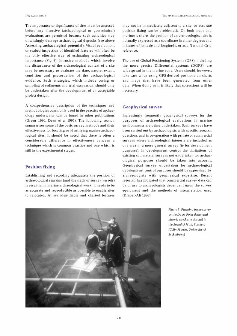
The importance or significance of sites must be assessedbefore any intrusive (archaeological or geotechnical)evaluations are permitted because such activities mayunwittingly damage archaeological deposits (see aboveAssessing archaeological potential). Visual evaluation,or seabed inspection of identified features will often bethe only effective way of estimating archaeologicalimportance (Fig 3). Intrusive methods which involve the disturbance of the archaeological context of a sitemay be necessary to evaluate the date, nature, extent,condition and preservation of the archaeological evidence. Such strategies, which include coring or sampling of sediments and trial excavation, should onlybe undertaken after the development of an acceptableproject design.
A comprehensive description of the techniques andmethodologies commonly used in the practice of archae-ology underwater can be found in other publications(Green 1990, Dean et al 1995). The following section summarises some of the basic survey methods and theireffectiveness for locating or identifying marine archaeo-logical sites. It should be noted that there is often a considerable difference in effectiveness between a technique which is common practice and one which isstill in the experimental stages.
Position fixing
Establishing and recording adequately the position ofarchaeological remains (and the track of survey vessels)is essential in marine archaeological work. It needs to beas accurate and reproducible as possible to enable sitesto relocated. At sea identifiable and charted features
may not lie immediately adjacent to a site, so accurateposition fixing can be problematic. On both maps andmariner’s charts the position of an archaeological site isnormally expressed as a coordinate in either degrees andminutes of latitude and longitude, or as a National Gridreference.
The use of Global Positioning Systems (GPS), includingthe more precise Differential systems (DGPS), are widespread in the marine zone. Users should, however,take care when using GPS-derived positions on chartsand maps that have been generated from other data. When doing so it is likely that corrections will benecessary.
Geophysical survey
Increasingly frequently geophysical surveys for the purposes of archaeological evaluations in marine environments are being undertaken. Such surveys havebeen carried out by archaeologists with specific researchquestions, and in co-operation with private or commercialsurveys where archaeological interests are included asone area in a more general survey (ie for developmentpurposes). In development control the limitations ofexisting commercial surveys not undertaken for archae-ological purposes should be taken into account.Geophysical survey undertaken for archaeologicaldevelopment control purposes should be supervised byarchaeologists with geophysical expertise. Recentresearch has indicated that commercial survey data canbe of use to archaeologists dependent upon the surveyequipment and the methods of interpretation used(Draper-Ali 1996).
IFA PAPER NO. 4 THE MARITIME ARCHAEOLOGICAL RESOURCE
20
Figure 3 Planning frame survey
on the Duart Point designated
historic wreck site situated in
the Sound of Mull, Scotland
(Colin Martin, University of
St Andrews)

IFA PAPER NO. 4
Geophysical surveys require systematic and detailedplanning based upon the anticipated archaeologicalremains in the target area, site conditions, and the char-acteristics of the survey techniques and position-fixingsystem to be used (Bell and Novak 1993). Guidelines on the initial surveys of project areas to determine thepresence of potential archaeological resources have beendrafted by the US Department of the Interior MineralsManagement Service (MMS 1994).
Visual search techniques
Visual search methods are probably the easiest methodof site location to understand and use but underwatervisibility is often poor, making visual searches difficultto carry out efficiently. Seabed search, either by divers orremotely operated vehicle (ROV), is seldom a practicaloption as a technique for the location of new archaeo-logical sites in a particular area unless the area is verylimited (eg the line of a pipe or cable). Visual underwatersurveys using divers are affected by the amount of timea diver is able to remain underwater. Factors that limit adiver’s time are physical endurance (cold will causeexhaustion and loss of concentration) and nitrogen narcosis which significantly affects mental ability atdepths below 30m. As depth increases the amount oftime allowed for a ‘non decompression’ dive decreasesrapidly. ‘No decompression’ time is the amount of timea diver can spend at the bottom and return unaffected tothe surface.
It is important that any underwater search is organisedto ensure that diving time is used effectively. Techniquesof diver survey are described in Dean et al (1995).
Still and video cameras
If a camera is towed behind a boat or mounted in a ROVthen it is possible to observe large areas of the seabedfrom the surface. Satellite and radio links can mean thatthe observer does not even have to be on the survey vessel.In shallow water underwater photography can be limitedby the attenuation of light and the light-scattering effectof suspended particles (Fig 4). In some cases it may benecessary to have the camera very close (ie millimetres)to the subject being photographed.
Magnetic
Underwater magnetometers are useful for locating magnetic anomalies caused by large ferrous objects and structure such as iron ships, cannon and shot. Thesimplest magnetometers give an audible signal when thefield strength changes. More sophisticated devices willproduce actual values. The sensor can be towed and
21
THE MARITIME ARCHAEOLOGICAL RESOURCE
Geophysical survey: summary
• choose optimum instrumentation in relation to survey area,environment and goals
• control position fixing
• plan survey lanes taking into account layback of sensorbehind the vessel
Factors to be determined before undertaking a diver survey: summary
• the extent of the search area
• the type and size of the object being searched for
• time allowed for searching
• depth
• the legal implications of ‘Diving at Work’
Figure 4 Archaeologist using surface supplied breathing gas and
helmet-mounted video for survey on the Designated Historic Wreck
site of the Resurgam submarine (1880), with an Remote Operated
Vehicle (ROV) (Archaeological Diving Unit, University of St
Andrews)

THE MARITIME ARCHAEOLOGICAL RESOURCEIFA PAPER NO. 4
22
readings recorded, from which an intensity map isdrawn up for interpretation (Fig 5). The latter processesare often carried out some time after the survey itself.
It is important to be aware that a large target far from thedetector can give the same strength signal as smallerobjects closer to the detector, so the distance of the detectorfrom the seabed needs to be known. Natural featuressuch as rock formations containing iron may also affectthe survey.
Metal-detectors
Metal-detectors have the advantage over magnetometersin that they can detect non-ferrous metals, such as gold,silver and bronze. For this reason they are used by treasure hunters underwater to search for items with anintrinsic value. As is the case on land, a metal-detectorcan be a very useful tool for archaeological survey of a site, particularly for intensively searching small areas.Hand-held underwater metal-detectors register the
Figure 5 Geometrics 880 magnetometer survey: designated wreck site at Dunwich Bank, Suffolk
(Archaeological Diving Unit, University of St Andrews)

IFA PAPER NO. 4
23
THE MARITIME ARCHAEOLOGICAL RESOURCE
presence of metals by an audio or visual signal and theyhave a limited detection range. Towed forms of metal-detector do exist but the very short range of detectionmakes them of limited use for archaeological surveys(Green 1990).
Sonar-based systems
Any active sonar system from a simple depth sounder tomore sophisticated side-scan sonar rely upon the behaviourof sound waves in seawater. Active sonar systems transmitsound energy and receive the returning echoes fromobstructions. Sonar systems do not actually measuredepth or distance but the time it takes for the transmittedsonar pulse to travel from the unit to the target andreturn. The accuracy of the sonar depends on the abilityto measure this time precisely, and the range is related totravel time by the speed of sound in water.
Sonar-based survey systems are becoming very sophisti-cated in terms of the post-processing of the returnedacoustic signals. It is claimed that some sonar systemshave the capability to discriminate between differentseabed environments eg between immature, mature anddead kelp cover. Such techniques may prove useful inthe future for identifying signatures of the various typesof archaeological feature, thus enabling large areas ofseabed to be effectively mapped in a short time.
Echo-sounder
Echo-sounders are one of the simplest acoustic systems.They are based upon the return of sound signalsbounced off the seabed vertically below a vessel. In thisconfiguration they are usually used to collect bathymetric(or depth) data (see Fig 5). A wreck or any other featurestanding above seabed level can usually be seen on anecho-sounder trace (Green 1990) but such a system islimited because of its beam width which gives a verynarrow search path. In other words the survey vesselwill have to pass directly over the target. By careful linespacing and search planning, however, this method isuseful in pinpointing the exact position of a site once itsgeneral location has been determined.
Side-scan sonar
Side-scan sonar can be more useful to archaeologists asit displays data in a form similar to oblique aerial photographs. In this case the source of the sound beamis usually fixed to either side of a sensor (or ‘fish’) towedbehind the survey vessel. Again, as with echo-sounding,the display represents the time taken for the sound pulseto travel from the unit to the target and return. This
distance is then plotted on electro-sensitive paper (orviewed on a VDU screen) with shading proportional tothe echo strength so that stronger echoes produce darkerlines. As the sensor is moved forward successive linesproduce an image of the sea floor and a pattern of darkreturns and shadows reveals the shape of any upstandingobject (Fig 6). In addition to locating material from awreck itself, side scan sonar may detect wreck marksproduced by the wreck’s effect on sediment characteristicsin the vicinity such as patterns of sand and gravel generated by scouring.
Sub-bottom profiler
Sub-bottom profilers (or penetrating echo-sounders)provide information about the material and the structureof the seabed itself. A high-energy sound beam is directedvertically downwards providing data on depth andnature of the sediment and any underlying features suchas rocks, pipelines and sections of shipwreck below theseabed. It is fair to say that sub-bottom data are often difficult to interpret and recently trials have been carriedout to compare the effectiveness of a number of different
Figure 6 Side-scan sonar survey of the wreck of the former
Trans-Atlantic ‘Blue Riband’ winning passenger liner Campania,
latterly converted to one of the first aircraft carrying warships,
situated in the Firth of Forth. The long sonar shadows to the right
of the 190m long wreck indicate that some areas stand over 10m up
from the seabed (Archaeological Diving Unit and School of Geology
and Geosciences, University of St Andrews)

THE MARITIME ARCHAEOLOGICAL RESOURCEIFA PAPER NO. 4
24
types of equipment over underwater sites that hadalready been surveyed by conventional means (Quinn etal 1997).
Intrusive investigations
Several methods of intrusive investigation can be usedon marine archaeological sites but it must be realisedthat, because of the nature and mobility of marine envi-ronments, such sites can suffer significant damage dueto the exposure of contexts and features. The same factorscan also compromise coring for stratigraphic analysisdue to the smearing of soft layers by the coring instrumentor contamination by the introduction of extraneous matter(Dean et al 1995).
Probing can be used to locate sediments or structuresbeneath shallow surface layers and this technique maybe useful in defining such factors as the limits of a site,the state of preservation of structural elements and thedepth of burial. Since the operation relies upon sense oftouch, the results of probing underwater can be difficultto measure and interpret. Probing must be carried outsystematically with adequate position fixing.
Coring can be a cost-effective method of mapping depositswithin a limited area but it is unlikely to provide adequatedating evidence or, in many cases, categorical evidenceof the presence of archaeological material. Engineeringboreholes are often not recorded in an appropriate wayfor archaeological purposes. This can be partly alleviatedby the presence of a suitably qualified archaeologist during the coring operation to augment the engineeringdescriptions with archaeological observations. Diver-operated corers are generally only practical in shallowsoft sediments. For harder or deeper sediments surface-operated coring systems are likely to be more effective.
Excavation is clearly the most damaging form of intrusive investigation. On land trial trenching is oftenused to test large areas for the presence of archaeologicaldeposits, yet trial excavation by divers is usually timeconsuming, expensive and will in most cases be outsidewhat can be claimed to be ‘reasonably practicable’.Specific small-scale excavations may be necessary (andare practicable) to test identified deposits. Any excava-tions underwater should be carried out by experiencedarchaeologists who dive and who conform to Health andSafety legislation. The use of non-archaeologists, such ascommercial or recreational divers, is not acceptable.There are many different techniques for underwaterexcavation which in general are similar to land excavationbut employ different tools and take advantage of theunique properties of the underwater environment.Techniques of excavation are described in various texts(eg Green 1990, Dean et al 1995).
• • • • •
Conclusions
It is a time of rapid change in the field of marine archae-ology in the UK and overseas. This publication aims tomake a contribution towards establishing the best possibleframework for the treatment and management of themarine archaeological resource. It should be explicitlyrecognised that archaeological evidence and sites existbeneath the sea and they must be managed effectivelyfor the benefit of present and future generations. Themarine archaeological resource transcends contemporaryenvironmental boundaries and historically derivedadministrative limits.
Our aim must be to protect and conserve the marinearchaeological resource but at the same time promoteaccess for legitimate purposes such as enjoyment,research and education. To achieve these aims the following would be desirable
• sustained and comprehensive research into thenature, extent, condition and potential of theresource
• a greater understanding of the processes of changein marine environments
• development control procedures in the marine zone to be at least equivalent to those on land
• effective strategies and structure for promoting public education and access opportunities
• planning policy guidance to apply explicitly toarchaeology within the UK territorial waters
Finally there is a critical need to develop procedures and opportunities for the training and education ofarchaeologists with the capabilities of working in themarine environment.
• • • • •
Marine archaeological evaluation techniques: summary
• Most, but not all, land-based archaeological techniques canbe adapted for use underwater
• They make take a bit longer and thus be more expensive
• A wide variety of routine evaluation methods are available
• Geophysical and other remote techniques are rapidlydeveloping

IFA PAPER NO. 4 THE MARITIME ARCHAEOLOGICAL RESOURCE
25
Bibliography
Allen A, 1995 Museums and maritime archaeology, North ofEngland Museums Service and Cleveland CountyArchaeological Service, Newcastle
Allen M J, Gardiner J, Fontana, D, and Pearson, A, 1993Archaeological assessment of Langstone Harbour, Hampshire,PAST 16, 1–3
Allen M J and Gardiner J, 2000 Our Changing Coast: a survey ofthe intertidal archaeology of Langstone Harbour, Hampshire, CBAResearch Report 124 Council for British Archaeology, York
Archaeological Diving Unit, 1998 Guide to Historic Wreck Sitesdesignated under the Protection of Wrecks Act 1973, University of StAndrews, St Andrews. World Wide Web, URL, http://www.st-and.ac.uk/institutes/sims/deswreck.html
Babits L E and Van Tilburg H (eds), 1998 Maritime archaeology: areader of substantive and theoretical contributions, PlenumPublishing Corporation, New York
Baldwin R, 1994 The legislation and institutional context: themaritime heritage, in Manual of heritage management (Ed RHarrison), Butterworth Heineman Ltd, Oxford 171–83
Ballard R D, McCann A M, Yoerger D, Whitcomb L, Mindell D,Oleson J, Singh H, Foley B, Adams J, Piechota D, Giangrande C,2000 The discovery of ancient history in the deep sea usingadvanced deep submergence technology, Deep-Sea Research I47, 1591-1620
Bell D L, and Novak T A, 1993 Some quality control considera-tions of remote sensing survey for archaeological sites, inUnderwater archaeological proceedings from the Society for HistoricalArchaeology conference, Kansas City 1993, (ed S O Smith), Societyfor Historical Archaeology Tucson 145–150
Breen C, 1996 Maritime archaeology in Northern Ireland: aninterim statement, International Journal of Nautical Archaeology,25.1, 55–65
Buglass J, 1994 Lost at sea: maritime archaeology of the North Eastof England, Cleveland County Archaeology Section,Middlesborough
Civil and Marine Ltd, 1993 Production licence application Area409, North Coal Pit, southern North Sea, Environmental Statementbased on an Environmental Assessment carried out byOakwood Environmental
Coles B J, 2000 Doggerland: the cultural dynamics of a shiftingcoastline, in Coastal and Estuarine Environments: Sedimentology,Geomorphology and Geoarchaeology (Eds K Pye, JRL Allen).Special Publications 175, Geological Society, London, 393-401
Coles J M, 1987 Preservation of the past: the case for wet archaeology, in European wetlands in prehistory, (eds J M Colesand A J Lawson), Clarendon Press, Oxford 1–22
Corfield M, Hinton P, Nixon T, and Pollard M (eds), 1998Preserving archaeological remains in situ. Proceedings of the conference 1–3 April 1996, Museum of London ArchaeologyService and Department of Archaeological Sciences, Universityof Bradford, London
Commission on the European Communities, 2000Communication from the Commission to the Council and theEuropean Parliament on Integrated Coastal Zone Management: AStrategy for Europe. Commission of the European Communities,Brussels.
Countryside Commission, 1991 Heritage coasts in England: policies and priorities 1991, Cheltenham
Cuthill M, 1998 Managing the Yongala Historic Shipwreck,Coastal Management, 26: 33-46
Dean M L, Ferrari B J F, Oxley I, Redknap M and Watson K(eds), 1995 Archaeology underwater: the NAS guide to principlesand practice, Archetype Press Ltd. and Nautical ArchaeologySociety, London
Dean M, Lawrence M, Liscoe S., Oxley I & A Wood, 2000,Protected Historic Wrecks: Guidance Notes for Divers andArchaeologists. Archaeological Diving Unit, University of StAndrews, St Andrews.
Department of the Environment, 1990 Planning Policy GuidanceNote 16: Archaeology and Planning, HMSO, London
Department of the Environment, 1992 Coastal Zone Protectionand Planning: the Government’s Response to the Second Report fromthe House of Commons Select Committee on the Environment,HMSO, London
Department of the Environment, 1993 Coastal Planning andManagement. a Review, HMSO. London
Department of the Environment, 1994 PPG 15: Planning and theHistoric Environment, HMSO, London
Department of the Environment and Welsh Office, 1992 PlanningPolicy Guidance Note 20: Coastal Planning, HMSO, London
Department of the Environment, Transport and the Regions(DETR), 1998 Government View: New Arrangements for theLicensing of Minerals Dredging, DETR), London
Draper-Ali S, 1996 Marine Archaeology and Geophysical Survey: aReview of Commercial Survey Practice and its contribution toArchaeological Prospection, Hampshire and Wight Trust forMaritime Archaeology, Southampton
Dromgoole, S, 1996 Military Remains on and around the Coastof the United Kingdom: Statutory Mechanisms of Protection,International Journal of Marine and Coastal Law, 11.1: 23-45
English Heritage, 1999 Towards a policy for marine archaeology: anEnglish Heritage and RCHME discussion paper, Consultationdraft, March 1999, English Heritage, London.
English Nature, 1993 Managing Lundy’s wildlife – have your say!Management proposals for the marine nature reserve and Site ofSpecial Scientific Interest, Peterborough
Ferrari B J and Adams J, 1990 Biogenic modifications of marinesediments and their influence on archaeological material.International Journal of Nautical Archaeology, 19.2: 139-151
FHSMAP, 1998 Flamborough Head sensitive marine area manage-ment strategy. Flamborough Head sensitive marine area project,Sewerby Hall, Sewerby
Firth A, 1993 The management of archaeology underwater, inArchaeological resource management in the UK: an introduction (edsJ Hunter and I Ralston), Alan Sutton/Institute of FieldArchaeologists, Stroud, 65–76
Firth A, 1995 Archaeology and coastal zone management, inManaging ancient monuments: an integrated approach (ed A Berry),Clywd Archaeology Service, Mold, 155–167
Firth A, 1997 Marine archaeology, in 1997 Yearbook and directoryof members, Institute of Field Archaeologists, Manchester,MacMillan-Scott Plc, Cheshire
Firth A, 2000 Development-led archaeology in coastal environ-ments: investigations at Queenborough, Motney Hill andGravesend in Kent, UK. In: Coastal and EstuarineEnvironments: Sedimentology, Geomorphology And Geoarchaeology(eds K Pye, JRL Allen). Special Publications 175, GeologicalSociety, London, 403-417

THE MARITIME ARCHAEOLOGICAL RESOURCEIFA PAPER NO. 4
26
Firth A, Watson K and C Ellis, 1997 Tamar estuaries historic environment: a review of marine and coastal archaeology, PlymouthArchaeology Occasional Publication No 3, Tamar estuaries historic environment forum, Plymouth
Forth Estuary Forum, 1998 The Forth, the way forward: a discussionpaper, Forth estuary forum, Edinburgh
Fulford M, Champion T and Long A, 1997 England’s coastal heritage: a survey for English Heritage and the RCHME, EnglishHeritage, London
Gilman P J, Buckley D G and Wallis S, 1995 Saltmarsh loss tomanaged retreat in Essex: an integrated approach to the archae-ological management of a changing coastline, in Managingancient monuments: an integrated approach, (ed A Berry), ClywdArchaeology Service, Mold, 143–154
Goodheart A, 1999 Into the depths of history: with robotsexploring the bounty of shipwrecks on the ocean floor, we arefaced with the issue whether to take it or leave it. Preservation,51.1, 36–45
Green J, 1990 Maritime archaeology: a technical handbook,Academic Press, London
Gregory D J, 1996 Formation processes in underwater archaeology: astudy of chemical and biological deterioration, unpubl PhD thesis,Univ Leicester
Henderson G, 1994 Current international initiatives in protectingunderwater cultural resources, in Underwater archaeology proceedings from the Society for Historical Archaeology conference,Vancouver 1994, (eds R P Woodward and C D Moore), Societyfor Historical Archaeology, Tucson, 140–44
Heritage Coast Forum, 1993 Coastal archaeology, Heritage Coast10, Manchester
Highland Regional Council, 1995 Maritime and underwaterarchaeology in the Highland Region: archaeological sites and finds –what to do if you find something! Inverness
Historic Scotland, 1999 Conserving the Underwater Heritage,Operational Policy Paper, HP6, Historic Scotland, Edinburgh.
Hunter J R, 1994 ‘Maritime Culture’: notes from the land,International Journal of Nautical Archaeology, 23.4, 261–264
Hunter J, and Ralston I (eds), 1993 Archaeological resource management in the UK: an introduction, Alan Sutton/ Institute ofField Archaeologists, Stroud
ICOMOS, 1998 International charter on the protection and management of underwater cultural heritage. InternationalJournal of Nautical Archaeology, 27.3: 183-187
Institute of Field Archaeologists, 1997 By-laws of the Institute ofField Archaeologists, Code of conduct, IFA, Reading
Institute of Field Archaeologists, 1998 By-laws of the Institute ofField Archaeologists, Code of approved practice for the regulation ofcontractual arrangements in field archaeology, IFA, Reading
Institute of Field Archaeologists, 1999 Standard and guidance forarchaeological desk-based assessment, IFA, Reading
Institute of Field Archaeologists, 1999 Standard and guidance foran archaeological watching brief, IFA, Reading
Institute of Field Archaeologists, 1999 Standard and guidance forarchaeological field evaluation, IFA, Reading
Institute of Field Archaeologists, 2001 Yearbook and directory ofmembers, Cathedral Communications Ltd, Tisbury, Wilts.
Joint Nautical Archaeology Policy Committee, 1989 Heritage atsea: proposals for the better protection of archaeological sites under-water, National Maritime Museum, Greenwich
Joint Nautical Archaeology Policy Committee, 1993 Still at sea,National Maritime Museum, Greenwich
Joint Nautical Archaeology Policy Committee, 1995 Code of practicefor seabed developers, Royal Commission on the HistoricalMonuments of England, Swindon
JNAPC, 2000a Heritage Law at Sea: Proposals for Change, JointNautical Archaeology Policy Committee, The School of LegalStudies, University of Wolverhampton, Wolverhampton.http://www.wlv.ac.uk/sls/resources/heritage.htm, 19/01/01
JNAPC, 2000b, Wreck Diving: Don’t Get Scuttled, Respect OurWrecks. Joint Nautical Archaeology Policy Committee, BSAC,SAA and PADI. Leaflet. Available from JNAPC (see Addresses).
Kaoru Y, and Hoagland P, 1994 The value of historic ship-wrecks: conflicts and management, Coastal Management, 22: 195-213
LGA, 2000 On the Edge: the coastal strategy, Local GovernmentAssociation Special Interest Group on Coastal Issues, LocalGovernment Association, London. http://www.lga.gov.uk/news/coastal.pdf, 19/01/01
Long A J and Roberts D H, 1997 Sea-level change, in Preservingarchaeological remains in situ. Proceedings of the conference 1–3April 1996 (eds M Corfield, P Hinton, T Nixon and M Pollard)Museum of London Archaeology Service and Department ofArchaeological Sciences, University of Bradford, London, 25–49
Macdonald J, 1994 Coastal and marine development: the envi-ronmental consultants view, Institute of Field ArchaeologistsMaritime Affairs Group Bulletin 4, 2–3
Martin C J M, 1995 Assessment, stabilisation, and managementof an environmentally threatened seventeenth-century ship-wreck off Duart Point, Mull, in Managing ancient monuments: anintegrated approach, (ed A Berry), Clywd Archaeology Service,Mold, 181–189
Mather I R and Watts Jr G P, 1998 Geographic InformationSystems for Submerged Cultural Resource Management andSite Specific Investigations. In Underwater Archaeology (Eds L EBabits, C Fach, and R H Harris). Tucson: Society for HistoricalArchaeology, pp. 3-13.
Merrett-Jones M, and Pedley S, 1998 Water quality and thedegradation of submerged timbers at three historic wreck sitesin the Solent, in Preserving archaeological remains in situ.Proceedings of the conference 1–3 April 1996 (eds M Corfield, P Hinton, T Nixon and M Pollard) Museum of LondonArchaeology Service and Department of ArchaeologicalSciences, University of Bradford, London, 174–186
Minerals Management Service, 1994 Guidelines for marine archaeological reconnaissance surveys, Virginia
Momber G, 2000 A submerged occupation site off BouldnorCliff, Isle of Wight, England. NewsWARP 28, 23-25
National Coasts and Estuaries Advisory Group (NCEAG), 1993Coastal planning and management: a good practice guide,
Nayling N, 1998 The Magor Pill medieval wreck, CBA ResearchReport 115, Council for British Archaeology, York
Oxley I, 1992 The investigation of the factors which affect thepreservation of underwater archaeological sites, in Underwaterarchaeology proceedings from the Society for Historical Archaeologyconference, Kingston, Jamaica 1992, (Eds D H Keith and T LCarrell), Society for Historical Archaeology, Tucson, 105–10
Oxley I, 1995 The assessment of the environment of archaeologicalsites underwater, in Science and site: evaluation and conservation,Proceedings of the conference 8–10 September 1993, (eds J Beavis, and K Barker), School of Conservation Sciences

IFA PAPER NO. 4 THE MARITIME ARCHAEOLOGICAL RESOURCE
27
Occasional Paper No 1, Bournemouth University,Bournemouth, 53–71
Oxley I, 1996 The development of an integrated approach tofield archaeology in the UK and the role of the ArchaeologicalDiving Unit (ADU), The bulletin of the Australian Institute ofMaritime Archaeology 20.2, 41–53
Oxley I, 1998a The in situ preservation of underwater sites, inPreserving archaeological remains in situ (eds M Corfield, PHinton, T Nixon and M Pollard). Proceedings of the conferenceof 1–3 April 1996, Museum of London Archaeology Service andDepartment of Archaeological Sciences, University of Bradford,London, 159–173
Oxley I, 1998b Archaeological shoreline management plans. Focalstudies for Historic Scotland. Unpubl report, Scottish Institute ofMaritime Studies, University of St Andrews
Oxley I, 2001 Maritime Fife: an integrated study of the maritimearchaeological and historical resource of Fife, in Archaeology incoastal landscapes. Proceedings of conference 29–31 March 1996(eds C Lewis and A Aberg), Institute of landscape studies andnautical archaeology society, Portsmouth University
Quinn R, Bull J M, Dix J K and Adams J R, 1997 The Mary Rosesite – geophysical evidence for palaeo-scour marks, InternationalJournal of Nautical Archaeology, 26.1, 3–16
Ratcliffe J, 1997 Fal estuary historic audit, CornwallArchaeological Unit, Cornwall County Council, Truro
Receiver of Wreck, 1994 Where to turn to when you’ve turned some-thing up, The Coastguard Agency, Southampton
Robertson P, 1995 Marine archaeology and Lundy marinenature reserve: an assessment for English Nature and theLandmark Trust, Unpubl report
Robinson D, and Aaby B, 1994 Pollen and plant macrofossilanalyses from the Gedesby ship: a medieval shipwreck fromFalster, Denmark, Vegetation History and Archaeobotany 3, 167–82
Robinson W, 1998 First aid for underwater finds, ArchetypePublications and Nautical Archaeology Society, London
Scottish Office Environment Department, 1994 NationalPlanning Policy Guideline 5: archaeology and planning,Edinburgh
Scottish Office Development Department, 1997 NationalPlanning Policy Guideline 13: coastal planning, Edinburgh
Srong I, 1999, Current status of the draft UNESCO/DAOLOSConvention for the Protection of the Underwater CulturalHeritage, Conservation and Management of Archaeological Sites, 3:155-158
Tomalin D, 1998 Bargaining with nature: considering the sustainability of archaeological sites in the dynamic environmentof the intertidal zone, in Preserving archaeological remains in situ(eds M Corfield, P Hinton, T Nixon and M Pollard).Proceedings of the conference of 1–3 April 1996, Museum ofLondon Archaeology Service and Department ofArchaeological Sciences, University of Bradford, London,144–158
Von der Porten E, 1994 Public perceptions, finances, and museums in nautical archaeology, in Crossroads in ancient ship-building (ed C Westerdahl), Oxbow Monograph 40, OxbowBooks, Oxford, 289–90
Ward I A K, Larcombe P, Veth P, 1999 A new process-basedmodel for wreck site formation, Journal of Archaeological Science,26, 561-570
Watson K J, and Gale A, 1990 Site evaluation for marine sites and monuments records: the Yarmouth Roads wreckinvestigations, International Journal of Nautical Archaeology, 19,183–92
Welsh Office 1996 Planning and the Historic Environment:Archaeology. Circular 60/96, Welsh Office.
Wessex Archaeology, 1999 Shoreline Management Plans and theHistoric Environment: Final Report of a Strategic Study for EnglishHeritage, Wessex Archaeology, Salisbury
Wright D J and Bartlett D J (Eds), 1999 Marine and coastalGeographical Information Systems, Taylor & Francis, London

THE MARITIME ARCHAEOLOGICAL RESOURCE
APPENDIX 1
Further information and addresses
GENERAL
Association of Local Government Archaeological Officers,Maritime Sub-Committee, c/o Ms C Ingle, HeritageConservation Group, Planning Division, Essex CountyCouncil, County Hall, Chelmsford, Essex CM1 1LF
Association of Regional and Island Archaeologists, c/o Stirling Council, Environmental Services, Viewforth,Stirling FK8 2ET Tel 01786 442752 Fax 01786 443003
Joint Nautical Archaeology Policy Committee, c/o Council for British Archaeology, Bowes Morrell House,111 Walmgate, York YO1 2UATel 01904 671417 Fax 01904 671384 http://www.britarch.ac.uk/
Nautical Archaeology Society, Fort Cumberland, FortCumberland Road, Eastney, Portsmouth PO4 9LD Tel/Fax 023 9281 8419 http://www.nasportsmouth.org.uk/
Receiver of Wreck, The Maritime and Coastguard Agency,Spring Place, 105 Commercial Road, Southampton SO15 1EGTel 01703 329474 Fax 01703 329477http://www.mcga.gov.uk/row/index.htm
Mineral and Waste Planning Division, Department of theEnvironment, Transport and the Regions, Zone 4/B1, Eland House, Bressenden Place, London SW1E 5DU Tel 0171 890 3872 Fax 0171 890 3859 http://www.detr.gov.uk/
ENGLAND
Secretary, Advisory Committee on Historic Wreck Sites,Department for Culture, Media and Sport, Heritage Division,Third Floor, 2–4 Cockspur St, London SW1Y 5DH Tel 020 7211 6200 http://www.culture.gov.uk/
English Heritage, National Monuments Record Centre,Kemble Drive, Swindon SN2 2GZ Tel 01793 414910 Fax 01793 414926 http://www.english-heritage.org.uk/
WALES
Cadw: Welsh Historic Monuments Executive Agency, 9th Floor, Brunel House, 2 Fitzalan Road, Cardiff CF2 1UYTel 029 20500200 Fax 029 2050 6375http://www.cadw.wales.gov.uk/
Royal Commission on Ancient and Historical Monuments inWales, Crown Buildings, Plas Crug, Aberystwyth,Ceredigion SY23 1NJ Tel 01970 621200 Fax 01970 627701http://www.rcahmw.org.uk/
SCOTLAND
Historic Scotland, Longmore House, Salisbury Place,Edinburgh EH9 1SH Tel 0131 668 8764 Fax 0131 668 8765 http://www.historic-scotland.gov.uk/sw-frame.htm
Royal Commission on the Ancient and Historical Monumentsof Scotland, John Sinclair House, 16 Bernard Terrace,Edinburgh EH8 9NX Tel 0131 662 1456 Fax 0131 662 1477http://www.rcahms.gov.uk/
NORTHERN IRELAND
Environment and Heritage Service, Historic Monuments andBuildings, 5–33 Hill Street, Belfast BT1 2LATel 028 9054 3037 Fax 028 9054 3111 http://www.ehsni.gov.uk/
DIVING AND HSE
HSE Approved Codes of Practice, guidance publications ondiving, and other HSE publications:HSE Books, PO Box 1999, Sudbury, Suffolk CO10 2WATel 01787 881165 Fax 01787 313995http://www.hsebooks.co.uk/homepage.html
Copies of Diving at Work Regulations, and other legislation:The Stationery Office, PO Box 276, London SW8 5DT Tel 0171 873 9090 Fax 0171 873 8200http://www.hmso.gov.uk/index.html
Technical queries about diving competence and qualifications, contractors, diving first aid and medics etc.:HSE, Diving and Quarries Section, 4th Floor - South Wing,Rose Court, 2 Southwark Bridge, London SE1 9HS Tel 0207 717 6592http://www.hse.gov.uk/spd/noframes/div_qual.htm
Information on archaeological diving practice:Maritime Affairs Special Interest Group, c/o IFA, University
of Reading, 2 Earley Gate, PO Box 239, Reading RG6 6AU Tel 0118 931 6446 Fax 0118 931 6448 http://www.archaeologists.net
Archaeological Diving Unit, University of St Andrews, St Andrews, Fife KY16 9AJ Tel 01334 462919 Fax 01334 462921 http://www.adu.org.uk
IFA TECHNICAL PAPER NO. 4
28
Other technical papers available from IFA include:
No 1 1997 Lesley M Ferguson and Diana M Murray ArchaeologicalDocumentary Archives
No 2 1999 Mhairi Handley Microfilming Archaeological Archives
No 3 2001 Margaret Cox Crypt Archaeology (electronic publication)
No 4 2001 Ian Oxley The Marine Archaeological Resource (electronicpublication)
No 5 2001 John Hodgson Archaeological reconstruction: illustrating the past
The Institute of Field Archaeologists (IFA) is the professionalbody for archaeologists. It promotes best practice in archaeologyand has almost 1600 members across the UK and abroad.Archaeologists who are members of IFA work in all branches ofthe discipline: underwater and aerial archaeology, heritage management, excavation, finds and environmental study, buildings recording, museums, conservation, survey, research and development, teaching, and liaison with the community,industry and the commercial and financial sectors. IFA publications include a quarterly magazine, a Yearbook,numerous Standards and Guidance notes, and technical papers.
Institute of Field Archaeologists
SHES, University of Reading, Whiteknights, PO Box 227, Reading RG6 6AB, United Kingdom
TEL 0118 378 6446 • FAX 0118 378 6448 • E-MAIL [email protected] • WEBSITE www.archaeologists.net