idaho transportation system pavement performance …apps.itd.idaho.gov/apps/pm/itd 2016 performance...
TRANSCRIPT
Cover Photo by Caleb Lakey, SH-162, Eastbound MM 13, District 2
If you have questions or would like to request further information, please contact Jim
Poorbaugh, Asset Management Engineer, at (208) 334-8841 or
Published June 15, 2017
2016
Jim Poorbaugh, P.E.
Asset Management Engineer
Idaho Transportation Department
P.O. Box 7129, Boise, ID
83707-1129
1/1/2016
Idaho Transportation System Pavement Performance Report
Idaho Transportation Department | 2016 Pavement Performance Report i
CONTENTS
EXECUTIVE SUMMARY ...................................................................................................................... II
1.0 INTRODUCTION/PURPOSE OF THIS REPORT ................................................................................... 1
2.0 PURPOSE OF A PAVEMENT MANAGEMENT SYSTEM (PMS) ............................................................... 1
3.0 THE CURRENT PAVEMENT MANAGEMENT SYSTEM (PMS) ............................................................... 1
4.0 PAVEMENT ANALYSIS DATA COLLECTION ...................................................................................... 3
5.0 HOW DO WE DETERMINE “DEFICIENCY”? ..................................................................................... 8
6.0 2015 STATE HIGHWAY CONDITION: CLASSIC METHODOLOGY .......................................................... 9
7.0 COMMERCE ROUTES ............................................................................................................... 13
8.0 HOW DOES ITD PREDICT AND RECOMMEND PAVEMENT PROJECTS? ................................................ 15
9.0 HOW DOES THE PMS CLASSIFY AND DETERIORATE PAVEMENT? ..................................................... 15
10.0 CONCLUSION ....................................................................................................................... 18
FIGURES Figure 1: Current Means of Pavement Data Collection ................................................................................. 3
Figure 2: ITD's New Profiler Van .................................................................................................................... 4
Figure 3: ITD's Friction Testing Truck ............................................................................................................. 4
Figure 4: ITD’S Current FWD, truck And GPS Horn ........................................................................................ 4
Figure 5: Example of 5.0 Crack Rating ........................................................................................................... 6
Figure 6:Example of 0.0 Crack Rating ............................................................................................................ 6
Figure 7: Auto Classification & Auto Crack Example ...................................................................................... 7
Figure 8: 20-Year Statewide Pavement Condition ....................................................................................... 10
Figure 9: 2016 Statewide Pavement Condition Rating Distribution ............................................................ 10
Figure 10: Change Year Over Year Pavment COndition Ratings .................................................................. 11
Figure 11: 2016 Pavement Condition Distribution By District ..................................................................... 12
Figure 12:Commerce Route Distribution by District .................................................................................... 13
Figure 13:Defficent Pavement by Route Type and District .......................................................................... 13
Figure 14:Map of Idaho Commerce Routes ................................................................................................. 14
TABLES Table 1: Cracking Types Collected in Idaho ................................................................................................... 6
Table 2: Classic Methodology Deficient Thresholds ...................................................................................... 8
Table 3: State Lane Mileage by District ......................................................................................................... 9
Table 4: District Deficient Lane Miles ............................................................................................................ 9
Table 5: The Greek Method Thresholds for PMS ......................................................................................... 16
Table 6: Greek Methodology Deficient Thresholds ..................................................................................... 16
Table 7: OCI Pavement Distress Types ........................................................................................................ 17
Idaho Transportation Department | 2016 Pavement Performance Report ii
EXECUTIVE SUMMARY Scope and objective: The Asset Management Engineer annually prepares this document in order to report
the current condition of ITD’s roadways. Additionally, this report provides insight into the means and
methods employed to collect, process, analyze and utilize data collected. Specifically discussed are the
new profiler van ITD acquired early in 2017 (see page 4), implementation of automatic crack detection
and classification software (see page 6), and an overview of the Overall Condition Index (OCI)
Methodology (See Page 17).
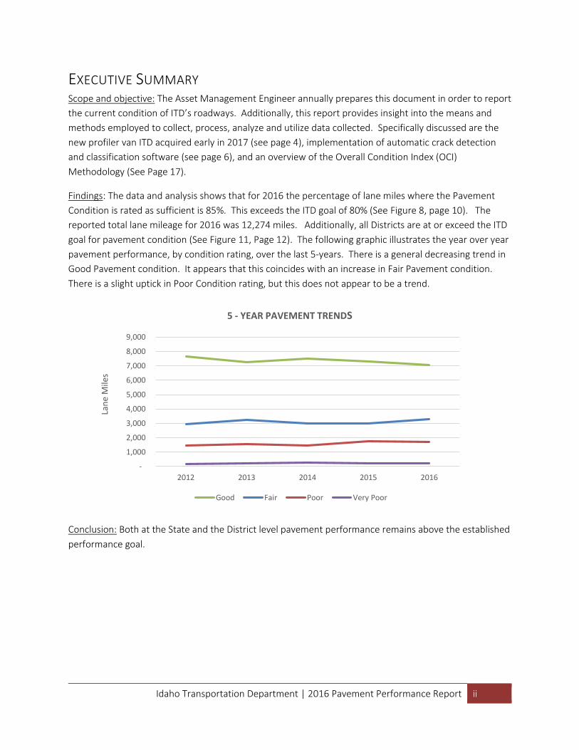
Findings: The data and analysis shows that for 2016 the percentage of lane miles where the Pavement
Condition is rated as sufficient is 85%. This exceeds the ITD goal of 80% (See Figure 8, page 10). The
reported total lane mileage for 2016 was 12,274 miles. Additionally, all Districts are at or exceed the ITD
goal for pavement condition (See Figure 11, Page 12). The following graphic illustrates the year over year
pavement performance, by condition rating, over the last 5-years. There is a general decreasing trend in
Good Pavement condition. It appears that this coincides with an increase in Fair Pavement condition.
There is a slight uptick in Poor Condition rating, but this does not appear to be a trend.
Conclusion: Both at the State and the District level pavement performance remains above the established
performance goal.
-
1,000
2,000
3,000
4,000
5,000
6,000
7,000
8,000
9,000
20162015201420132012
Lan
e M
iles
5 - YEAR PAVEMENT TRENDS
Good Fair Poor Very Poor
Idaho Transportation Department | 2016 Pavement Performance Report 1
1.0 INTRODUCTION/PURPOSE OF THIS REPORT The Idaho Transportation Department’s (ITD’s) Idaho Transportation System Performance Report is an
annual summary of the status of ITD-jurisdiction pavements. This report provides the reader with an
accurate and useful review of the historical and current condition of Idaho’s pavement. This report also
discusses the means and methods of data collection and analysis.
2.0 PURPOSE OF A PAVEMENT MANAGEMENT SYSTEM (PMS) A Pavement Management System (PMS) is defined as a system which involves the identification of
optimum strategies at various management levels and maintains pavements at an adequate level of
serviceability. These strategies include, but are not limited to, systematic procedures for scheduling
maintenance and rehabilitation activities to optimize benefit and minimize cost.
Historically, Idaho has managed about 5,000 centerline miles, or 12,000 lane miles, with additions and
subtractions annually. ITD strives to reduce deficient pavement and give motorists a safer and smoother
ride. Pavement deficiencies on the State Highway System have been reduced from 33% in 1995 to 15% by
the end of calendar year 2016. This has been accomplished by:
1. Continuously searching for more efficient ways to program pavement projects
2. Focusing on preservation and restoration before expansion, and applying cost savings to
pavement rehabilitation
3. Using a preventative maintenance program which slows the rate of pavement deterioration (a
preservation-first approach)
4. Improving the way, we collect, analyze, and report pavement data
5. Improving and updating project planning and construction project history
In 2009, the Idaho Transportation Department invested in a new pavement management system (PMS).
This system became active on December 17, 2010. This new PMS has greatly aided in the storage and
analysis of our data by providing a robust database in which to store data from several sections in a
central location. The new PMS also contains an analysis engine which accurately and consistently predicts
pavement deterioration. The new PMS is further explained in detail in Section 3.0, The Current Pavement
Management System (PMS).
3.0 THE CURRENT PAVEMENT MANAGEMENT SYSTEM (PMS) This section discusses the pavement management systems that ITD has used in the past, and how we
have come to use the system we do today. It describes in detail the current pavement management
system.
Idaho Transportation Department | 2016 Pavement Performance Report 2
A Brief History of Idaho Pavement Management In 1977, the Idaho Transportation Department began a review of existing pavement management programs with the goal of adopting one to fit Idaho’s needs. The following year, ITD acquired a Pavement Performance Management Information System (PPMIS) and made it operational on ITD’s mainframe computer. From 1978, ITD steadily improved the PPMIS and modified it to meet specific conditions in Idaho. It was tested and refined by both ITD and consultant contract. By 1986, it was able to perform simplistic economic analysis and optimization.
In 2007, ITD began running our pavement data through the HERS-ST (Highway Economic Requirements System, STate model). This online software from Federal Highway Administration (FHWA) uses pavement deterioration curves to predict pavement behavior. However, the HERS-ST model results had to be mathematically manipulated by hand in order to meet the conditions of Idaho weather, terrain and other factors, which was a painstaking process.
The Current PMS System In 2009, ITD purchased a pavement and maintenance management software package, AgileAssets Transportation Asset Management System (TAMS). This new software housed a pavement management system (PMS) and a maintenance management system (MMS) to work in tandem as part of the Department’s long-term vision for asset management. This software contains a robust database that houses several kinds of data, such as bridge and pavement condition, maintenance activities, traffic counts, surface friction values, boring logs and several others.
The Pavement Management System (PMS) has allowed ITD to refine the way we calculate and analyze data, by:
implementing new pavement performance curves calibrated by ITD engineers
implementing decision trees that mimic District engineering choices
creating performance models that accurately track and display pavement projects
employing an analysis engine that uses integer optimization to maximize benefit
These new abilities are helping Idaho become an efficient practitioner of preservation-first pavement management.
With all users of the PMS having instant access to all available data, the system has given the District pavement designers and engineers an extensive toolbox. The system suggests pavement project choices based on budget constraints and desired deficiency goals, which the engineers balance against needs and their expert knowledge of the system.
The Future PMS System ITD continues become more efficient in data management. Part of this evolution is changing the way in which we reference and refer to the location of roadway locations. The current PMS referencing basis uses segment codes and mileposts. This system has evolved and been utilized for many decades, however it’s utility is nearing an end rapidly as Geographic Information Systems (GIS) based on mapping coordinates (Latitude / Longitude) become more widely utilized. Newer PMS systems, even that provided by current vendor, require the use of a linear reference system (LRS) that is founded on GIS principles and based on geospatial coordinates. ESRI Roads and Highways is the GIS platform ITD has chosen to implement as our LRS. ITD has undertaken a project to identify, assess and implement a newer version of Asset Management Software compatible with ESRI Roads and Highways.
Idaho Transportation Department | 2016 Pavement Performance Report 3
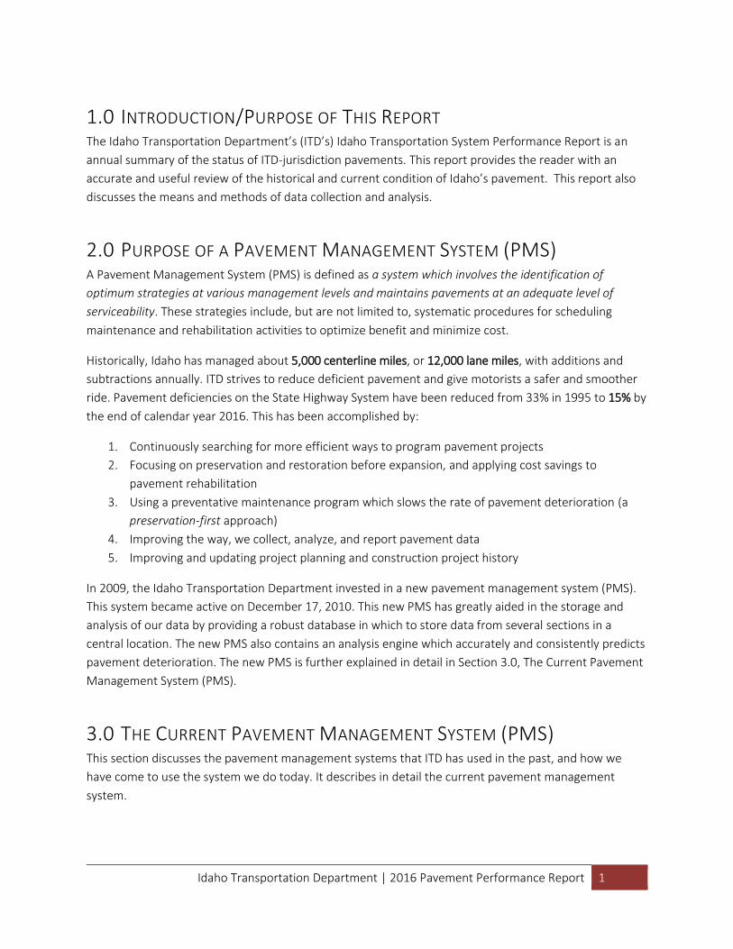
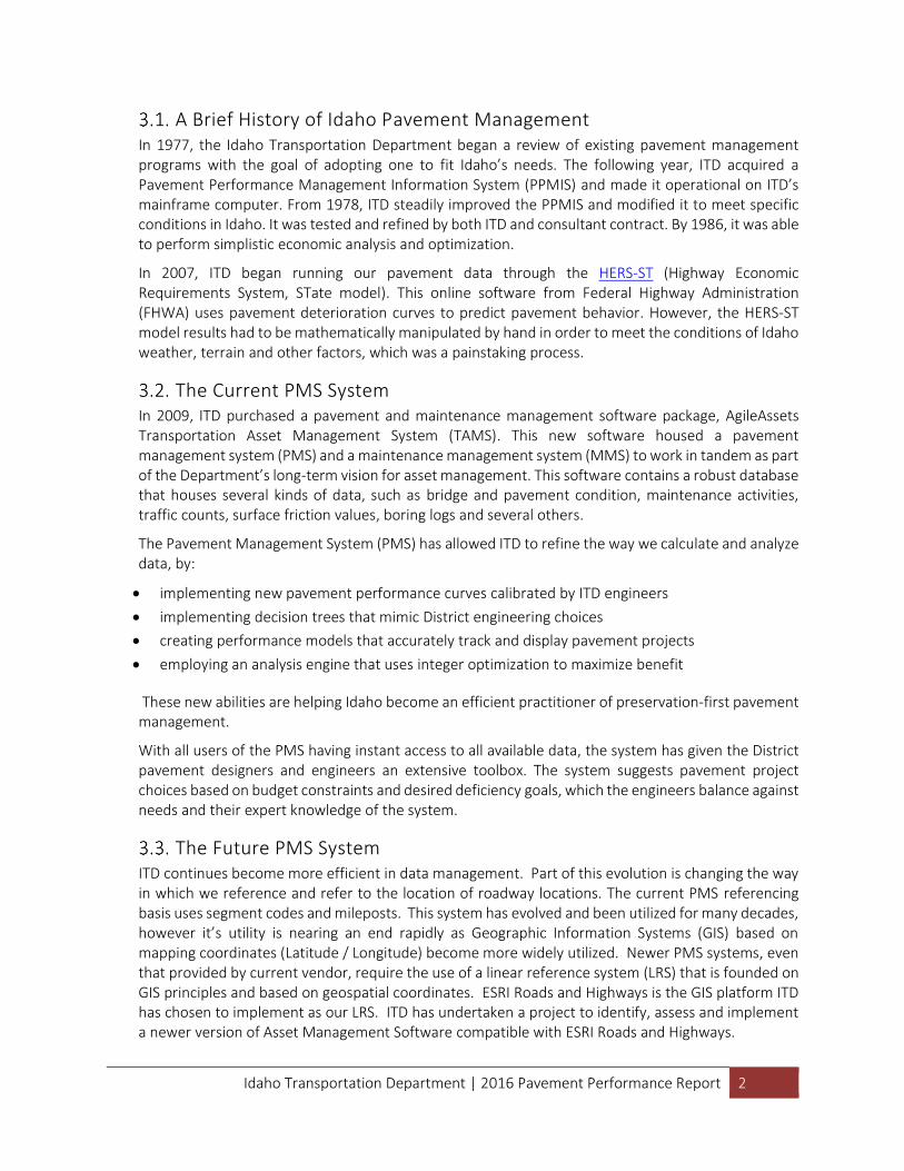
4.0 PAVEMENT ANALYSIS DATA COLLECTION Idaho collects pavement data annually, using two methods: visual windshield survey and a PathRunner Profiler van. The asset management engineer performs an annual inspection with a district
representative of every state highway by visual (windshield) inspection. This results in a crack index for the pavement (Section 4.1, below). The Profiler van drives the same highways, collecting thousands of miles of video images, rutting data, and roughness data. This results in a roughness index and a rutting depth (see Section 4.7, page 7)
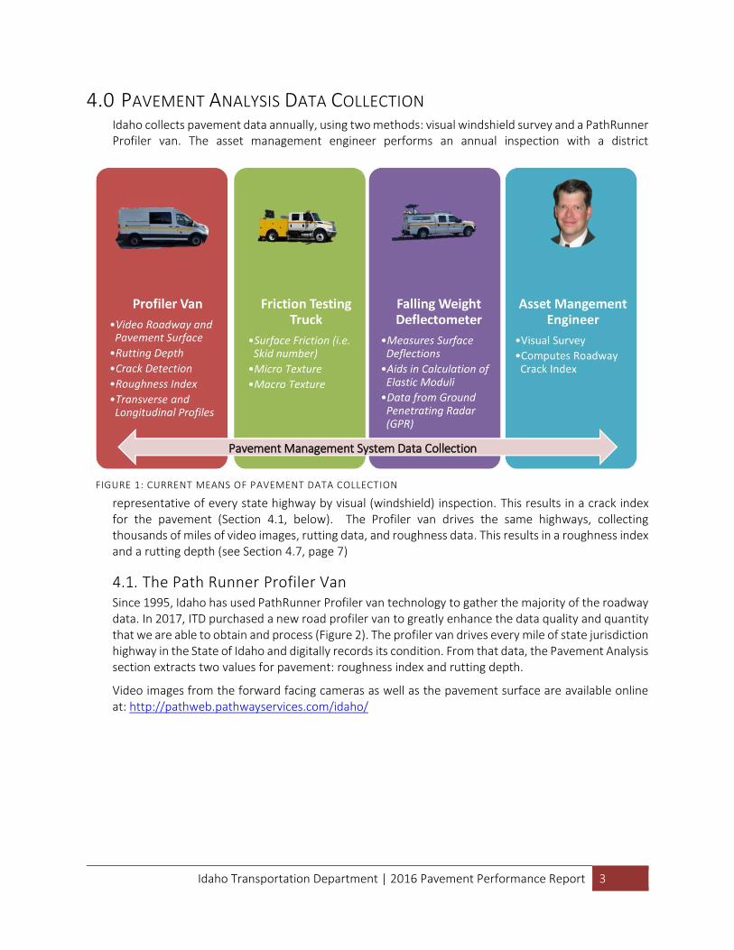
The Path Runner Profiler Van Since 1995, Idaho has used PathRunner Profiler van technology to gather the majority of the roadway data. In 2017, ITD purchased a new road profiler van to greatly enhance the data quality and quantity that we are able to obtain and process (Figure 2). The profiler van drives every mile of state jurisdiction highway in the State of Idaho and digitally records its condition. From that data, the Pavement Analysis section extracts two values for pavement: roughness index and rutting depth.
Video images from the forward facing cameras as well as the pavement surface are available online at: http://pathweb.pathwayservices.com/idaho/
FIGURE 1: CURRENT MEANS OF PAVEMENT DATA COLLECTION
Pavement Management System Data Collection
Idaho Transportation Department | 2016 Pavement Performance Report 4
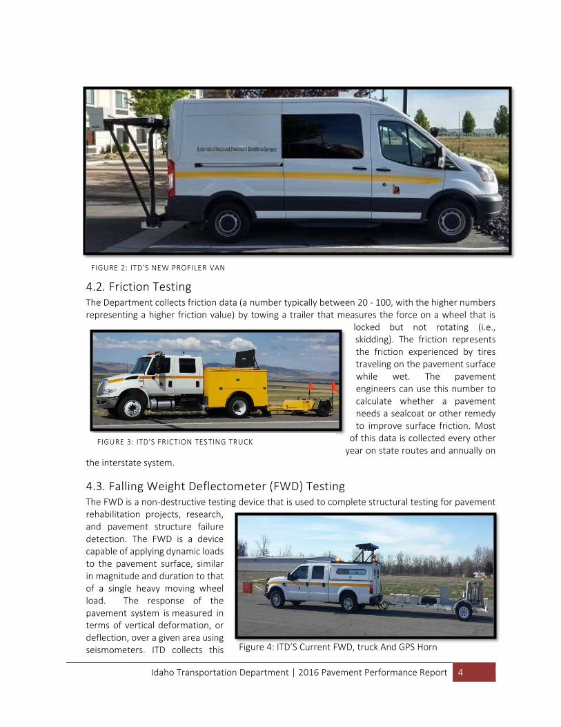
Friction Testing The Department collects friction data (a number typically between 20 - 100, with the higher numbers representing a higher friction value) by towing a trailer that measures the force on a wheel that is
locked but not rotating (i.e., skidding). The friction represents the friction experienced by tires traveling on the pavement surface while wet. The pavement engineers can use this number to calculate whether a pavement needs a sealcoat or other remedy to improve surface friction. Most
of this data is collected every other year on state routes and annually on
the interstate system.
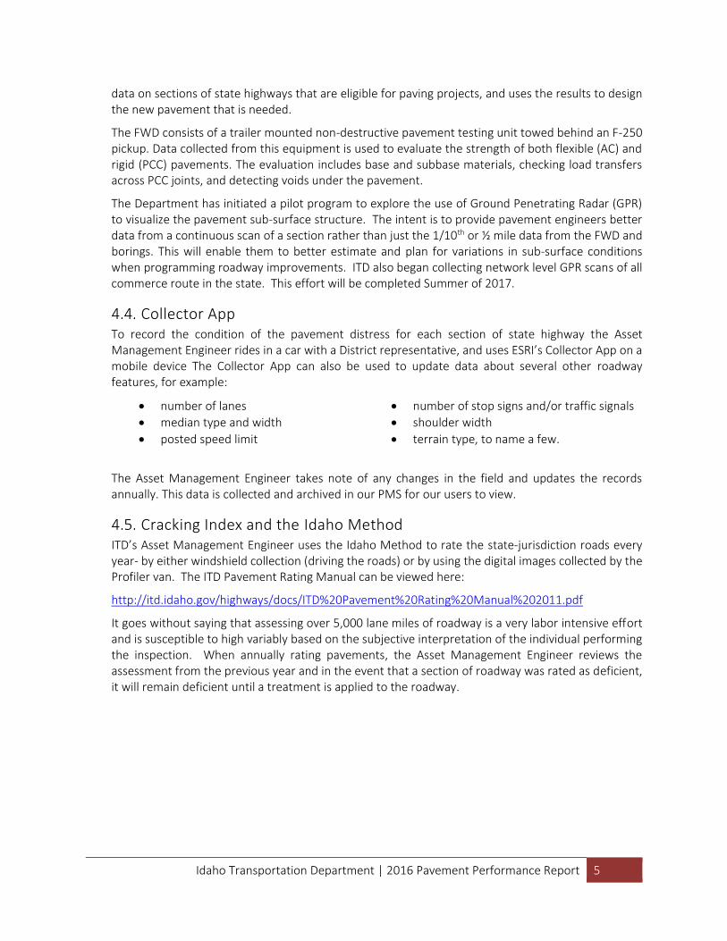
Falling Weight Deflectometer (FWD) Testing The FWD is a non-destructive testing device that is used to complete structural testing for pavement rehabilitation projects, research, and pavement structure failure detection. The FWD is a device capable of applying dynamic loads to the pavement surface, similar in magnitude and duration to that of a single heavy moving wheel load. The response of the pavement system is measured in terms of vertical deformation, or deflection, over a given area using seismometers. ITD collects this
FIGURE 2: ITD'S NEW PROFILER VAN
FIGURE 3: ITD'S FRICTION TESTING TRUCK
Figure 4: ITD’S Current FWD, truck And GPS Horn
Idaho Transportation Department | 2016 Pavement Performance Report 5
data on sections of state highways that are eligible for paving projects, and uses the results to design the new pavement that is needed.
The FWD consists of a trailer mounted non-destructive pavement testing unit towed behind an F-250 pickup. Data collected from this equipment is used to evaluate the strength of both flexible (AC) and rigid (PCC) pavements. The evaluation includes base and subbase materials, checking load transfers across PCC joints, and detecting voids under the pavement.
The Department has initiated a pilot program to explore the use of Ground Penetrating Radar (GPR) to visualize the pavement sub-surface structure. The intent is to provide pavement engineers better data from a continuous scan of a section rather than just the 1/10th or ½ mile data from the FWD and borings. This will enable them to better estimate and plan for variations in sub-surface conditions when programming roadway improvements. ITD also began collecting network level GPR scans of all commerce route in the state. This effort will be completed Summer of 2017.
Collector App To record the condition of the pavement distress for each section of state highway the Asset Management Engineer rides in a car with a District representative, and uses ESRI’s Collector App on a mobile device The Collector App can also be used to update data about several other roadway features, for example:
number of lanes
median type and width
posted speed limit
number of stop signs and/or traffic signals
shoulder width
terrain type, to name a few.
The Asset Management Engineer takes note of any changes in the field and updates the records annually. This data is collected and archived in our PMS for our users to view.
Cracking Index and the Idaho Method ITD’s Asset Management Engineer uses the Idaho Method to rate the state-jurisdiction roads every year- by either windshield collection (driving the roads) or by using the digital images collected by the Profiler van. The ITD Pavement Rating Manual can be viewed here:
http://itd.idaho.gov/highways/docs/ITD%20Pavement%20Rating%20Manual%202011.pdf
It goes without saying that assessing over 5,000 lane miles of roadway is a very labor intensive effort and is susceptible to high variably based on the subjective interpretation of the individual performing the inspection. When annually rating pavements, the Asset Management Engineer reviews the assessment from the previous year and in the event that a section of roadway was rated as deficient, it will remain deficient until a treatment is applied to the roadway.
Idaho Transportation Department | 2016 Pavement Performance Report 6
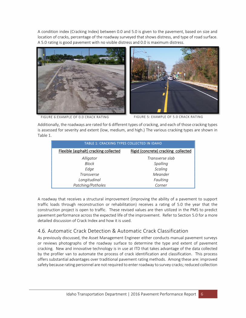
A condition index (Cracking Index) between 0.0 and 5.0 is given to the pavement, based on size and location of cracks, percentage of the roadway surveyed that shows distress, and type of road surface. A 5.0 rating is good pavement with no visible distress and 0.0 is maximum distress.
Additionally, the roadways are rated for 6 different types of cracking, and each of those cracking types is assessed for severity and extent (low, medium, and high.) The various cracking types are shown in Table 1.
TABLE 1: CRACKING TYPES COLLECTED IN IDAHO
Flexible (asphalt) cracking collected Rigid (concrete) cracking collected
Alligator Transverse slab Block Spalling Edge Scaling
Transverse Meander Longitudinal Faulting
Patching/Potholes Corner
A roadway that receives a structural improvement (improving the ability of a pavement to support traffic loads through reconstruction or rehabilitation) receives a rating of 5.0 the year that the construction project is open to traffic. These revised values are then utilized in the PMS to predict pavement performance across the expected life of the improvement. Refer to Section 5.0 for a more detailed discussion of Crack Index and how it is used.
Automatic Crack Detection & Automatic Crack Classification As previously discussed, the Asset Management Engineer either conducts manual pavement surveys or reviews photographs of the roadway surface to determine the type and extent of pavement cracking. New and innovative technology is in use at ITD that takes advantage of the data collected by the profiler van to automate the process of crack identification and classification. This process offers substantial advantages over traditional pavement rating methods. Among these are: improved safety because rating personnel are not required to enter roadway to survey cracks; reduced collection
FIGURE 5: EXAMPLE OF 5.0 CRACK RATING FIGURE 6:EXAMPLE OF 0.0 CRACK RATING
Idaho Transportation Department | 2016 Pavement Performance Report 7
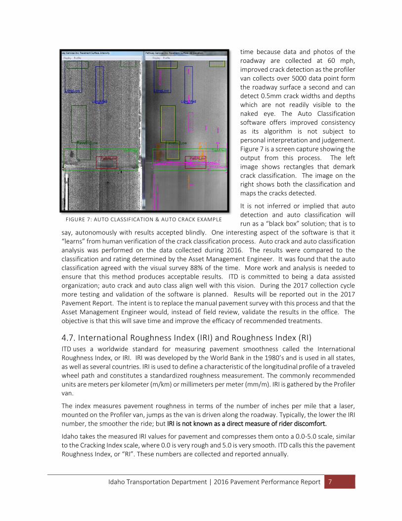
time because data and photos of the roadway are collected at 60 mph, improved crack detection as the profiler van collects over 5000 data point form the roadway surface a second and can detect 0.5mm crack widths and depths which are not readily visible to the naked eye. The Auto Classification software offers improved consistency as its algorithm is not subject to personal interpretation and judgement. Figure 7 is a screen capture showing the output from this process. The left image shows rectangles that demark crack classification. The image on the right shows both the classification and maps the cracks detected.
It is not inferred or implied that auto detection and auto classification will run as a “black box” solution; that is to
say, autonomously with results accepted blindly. One interesting aspect of the software is that it “learns” from human verification of the crack classification process. Auto crack and auto classification analysis was performed on the data collected during 2016. The results were compared to the classification and rating determined by the Asset Management Engineer. It was found that the auto classification agreed with the visual survey 88% of the time. More work and analysis is needed to ensure that this method produces acceptable results. ITD is committed to being a data assisted organization; auto crack and auto class align well with this vision. During the 2017 collection cycle more testing and validation of the software is planned. Results will be reported out in the 2017 Pavement Report. The intent is to replace the manual pavement survey with this process and that the Asset Management Engineer would, instead of field review, validate the results in the office. The objective is that this will save time and improve the efficacy of recommended treatments.
International Roughness Index (IRI) and Roughness Index (RI) ITD uses a worldwide standard for measuring pavement smoothness called the International Roughness Index, or IRI. IRI was developed by the World Bank in the 1980’s and is used in all states, as well as several countries. IRI is used to define a characteristic of the longitudinal profile of a traveled wheel path and constitutes a standardized roughness measurement. The commonly recommended units are meters per kilometer (m/km) or millimeters per meter (mm/m). IRI is gathered by the Profiler van.
The index measures pavement roughness in terms of the number of inches per mile that a laser, mounted on the Profiler van, jumps as the van is driven along the roadway. Typically, the lower the IRI number, the smoother the ride; but IRI is not known as a direct measure of rider discomfort.
Idaho takes the measured IRI values for pavement and compresses them onto a 0.0-5.0 scale, similar to the Cracking Index scale, where 0.0 is very rough and 5.0 is very smooth. ITD calls this the pavement Roughness Index, or “RI”. These numbers are collected and reported annually.
FIGURE 7: AUTO CLASSIFICATION & AUTO CRACK EXAMPLE
Idaho Transportation Department | 2016 Pavement Performance Report 8
5.0 HOW DO WE DETERMINE “DEFICIENCY”? The term “deficient” is used to indicate that a pavement has fallen below a certain threshold and requires
a structural remedy. In this section, we outline the Classic Methodology that ITD has used for several years
and show how ITD uses the thresholds to determine how to program the right remedy at the right time.
Classic Methodology: The 3-Legged Stool Historically, the pavement management system has used thresholds in the cracking index and roughness index to determine whether or not a pavement is “deficient.” These thresholds were triggered by two tiers of thresholds, based on the functional class of a roadway:
Tier 1: Interstates and arterials
Tier 2: Collectors
Districts would use the deficient threshold notification to realize that a roadway was ready for a structural project. Through 2009, the Classic Methodology employed only two measurements to determine deficiency: the cracking index and roughness index. In 2010, our improved Profiler van technology and the new PMS system led to the addition of a third measurement to determine deficiency, rutting depth. Rutting depth was first applied in 2010 as a method to rate pavements as deficient. Utilizing three criteria to determine deficiency is often referred to as “the 3-legged stool” model. The analogy is that if one leg of a 3-legged stool is broken, then the stool will not stand. Likewise, if any one of the three criteria that determine pavement deficient is met then the roadway is classified as deficient irrespective of the other two indices.
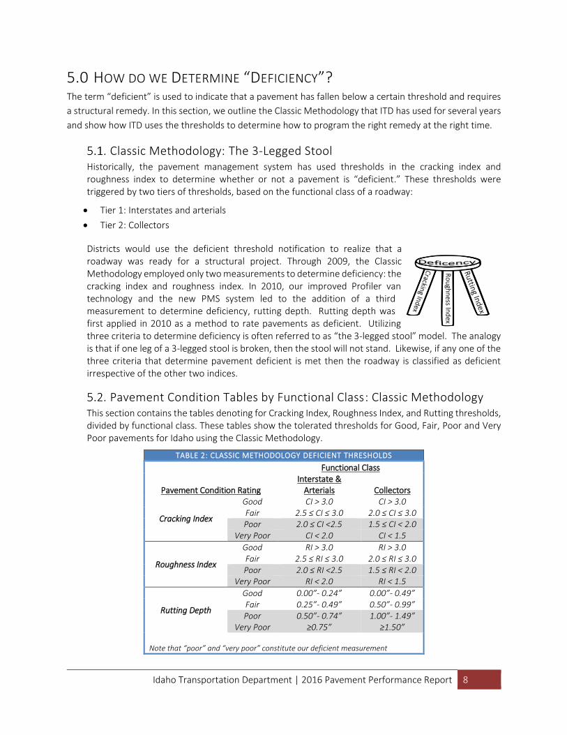
Pavement Condition Tables by Functional Class: Classic Methodology This section contains the tables denoting for Cracking Index, Roughness Index, and Rutting thresholds, divided by functional class. These tables show the tolerated thresholds for Good, Fair, Poor and Very Poor pavements for Idaho using the Classic Methodology.
TABLE 2: CLASSIC METHODOLOGY DEFICIENT THRESHOLDS
Pavement Condition Rating
Functional Class Interstate &
Arterials Collectors
Cracking Index
Good CI > 3.0 CI > 3.0 Fair 2.5 ≤ CI ≤ 3.0 2.0 ≤ CI ≤ 3.0 Poor 2.0 ≤ CI <2.5 1.5 ≤ CI < 2.0
Very Poor CI < 2.0 CI < 1.5
Roughness Index
Good RI > 3.0 RI > 3.0 Fair 2.5 ≤ RI ≤ 3.0 2.0 ≤ RI ≤ 3.0 Poor 2.0 ≤ RI <2.5 1.5 ≤ RI < 2.0
Very Poor RI < 2.0 RI < 1.5
Rutting Depth
Good 0.00”- 0.24” 0.00”- 0.49” Fair 0.25”- 0.49” 0.50”- 0.99” Poor 0.50”- 0.74” 1.00”- 1.49”
Very Poor ≥0.75” ≥1.50” Note that “poor” and “very poor” constitute our deficient measurement
Ro
ugh
ness In
dex
Idaho Transportation Department | 2016 Pavement Performance Report 9
6.0 2015 STATE HIGHWAY CONDITION: CLASSIC METHODOLOGY The following section details the condition of state highway pavement in Idaho for 2015 and previous years
using the methodology outlined in Section 5.0. In March 2017, 15% of the state-jurisdiction roads were
considered deficient by the Classic Methodology.
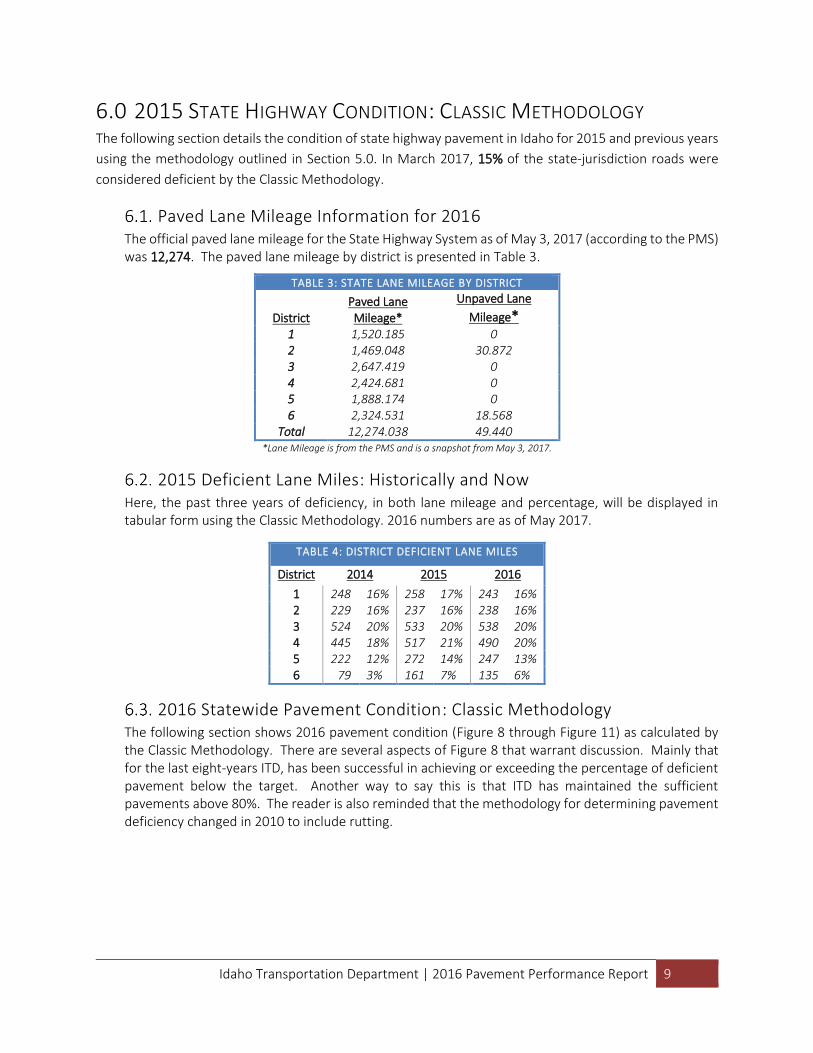
Paved Lane Mileage Information for 2016 The official paved lane mileage for the State Highway System as of May 3, 2017 (according to the PMS) was 12,274. The paved lane mileage by district is presented in Table 3.
TABLE 3: STATE LANE MILEAGE BY DISTRICT
District Paved Lane Mileage*
Unpaved Lane
Mileage*
1 1,520.185 0 2 1,469.048 30.872 3 2,647.419 0 4 2,424.681 0 5 1,888.174 0 6 2,324.531 18.568
Total 12,274.038 49.440 *Lane Mileage is from the PMS and is a snapshot from May 3, 2017.
2015 Deficient Lane Miles: Historically and Now Here, the past three years of deficiency, in both lane mileage and percentage, will be displayed in tabular form using the Classic Methodology. 2016 numbers are as of May 2017.
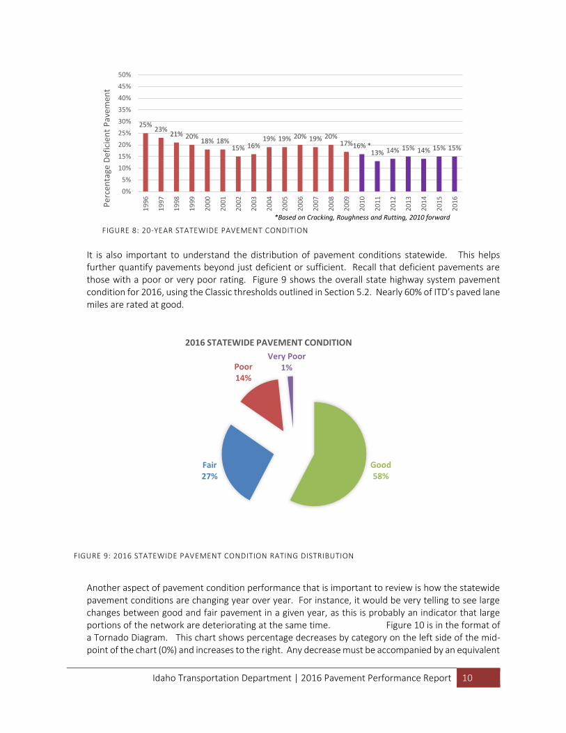
2016 Statewide Pavement Condition: Classic Methodology The following section shows 2016 pavement condition (Figure 8 through Figure 11) as calculated by the Classic Methodology. There are several aspects of Figure 8 that warrant discussion. Mainly that for the last eight-years ITD, has been successful in achieving or exceeding the percentage of deficient pavement below the target. Another way to say this is that ITD has maintained the sufficient pavements above 80%. The reader is also reminded that the methodology for determining pavement deficiency changed in 2010 to include rutting.
TABLE 4: DISTRICT DEFICIENT LANE MILES District 2014 2015 2016
1 248 16% 258 17% 243 16% 2 229 16% 237 16% 238 16% 3 524 20% 533 20% 538 20% 4 445 18% 517 21% 490 20% 5 222 12% 272 14% 247 13% 6 79 3% 161 7% 135 6%
Idaho Transportation Department | 2016 Pavement Performance Report 10
It is also important to understand the distribution of pavement conditions statewide. This helps further quantify pavements beyond just deficient or sufficient. Recall that deficient pavements are those with a poor or very poor rating. Figure 9 shows the overall state highway system pavement condition for 2016, using the Classic thresholds outlined in Section 5.2. Nearly 60% of ITD’s paved lane miles are rated at good.
Another aspect of pavement condition performance that is important to review is how the statewide pavement conditions are changing year over year. For instance, it would be very telling to see large changes between good and fair pavement in a given year, as this is probably an indicator that large portions of the network are deteriorating at the same time. Figure 10 is in the format of a Tornado Diagram. This chart shows percentage decreases by category on the left side of the mid-point of the chart (0%) and increases to the right. Any decrease must be accompanied by an equivalent
FIGURE 8: 20-YEAR STATEWIDE PAVEMENT CONDITION
25%23%
21% 20%18% 18%
15% 16%19% 19% 20% 19% 20%
17%16% *13% 14% 15% 14% 15% 15%
0%
5%
10%
15%
20%
25%
30%
35%
40%
45%
50%
19
96
19
97
19
98
19
99
20
00
20
01
20
02
20
03
20
04
20
05
20
06
20
07
20
08
20
09
20
10
20
11
20
12
20
13
20
14
20
15
20
16Per
cen
tage
Def
icie
nt
Pav
emen
t
*Based on Cracking, Roughness and Rutting, 2010 forward
FIGURE 9: 2016 STATEWIDE PAVEMENT CONDITION RATING DISTRIBUTION
Good 58%
Fair 27%
Poor 14%
Very Poor 1%
2016 STATEWIDE PAVEMENT CONDITION
Idaho Transportation Department | 2016 Pavement Performance Report 11
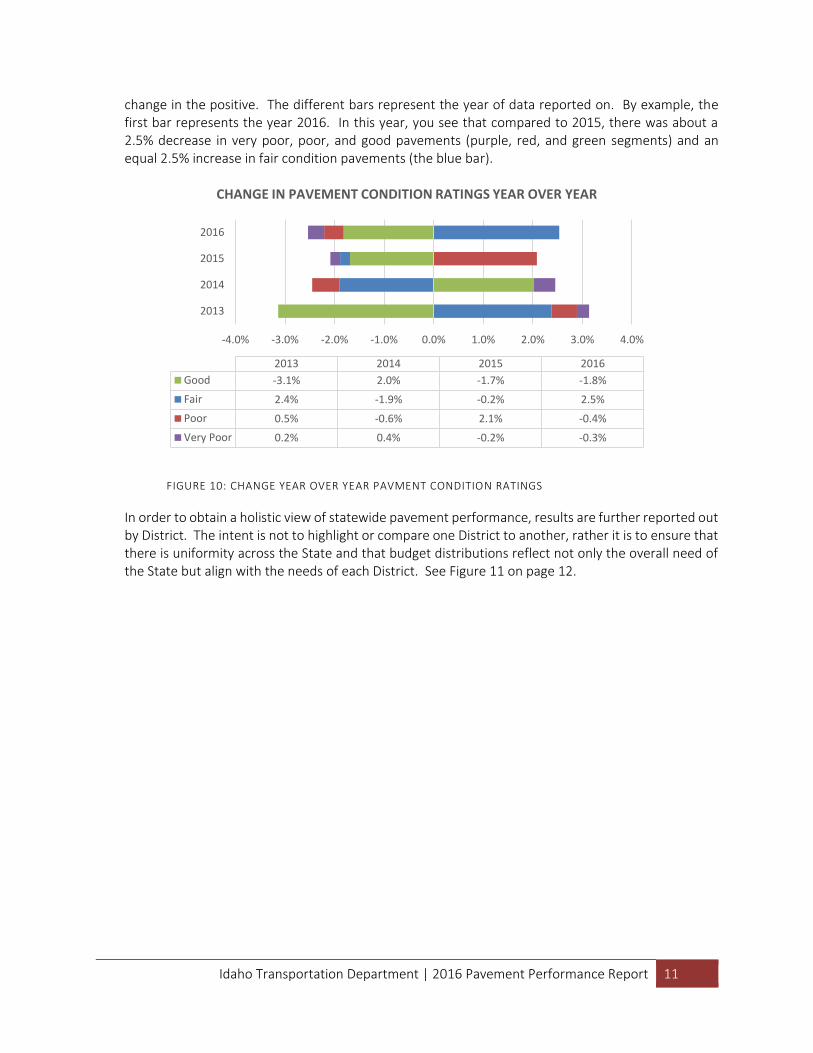
change in the positive. The different bars represent the year of data reported on. By example, the first bar represents the year 2016. In this year, you see that compared to 2015, there was about a 2.5% decrease in very poor, poor, and good pavements (purple, red, and green segments) and an equal 2.5% increase in fair condition pavements (the blue bar).
FIGURE 10: CHANGE YEAR OVER YEAR PAVMENT CONDITION RATINGS
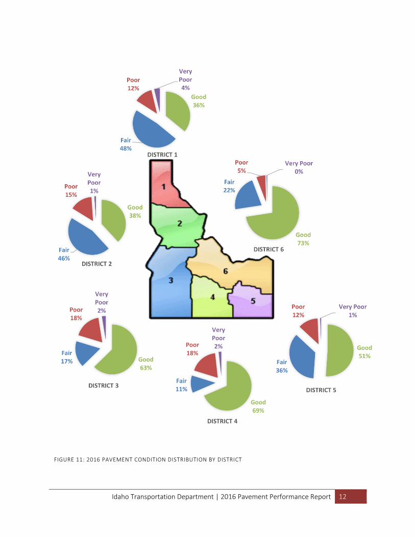
In order to obtain a holistic view of statewide pavement performance, results are further reported out by District. The intent is not to highlight or compare one District to another, rather it is to ensure that there is uniformity across the State and that budget distributions reflect not only the overall need of the State but align with the needs of each District. See Figure 11 on page 12.
-4.0% -3.0% -2.0% -1.0% 0.0% 1.0% 2.0% 3.0% 4.0%
2016
2015
2014
2013
2016201520142013
Good -1.8%-1.7%2.0%-3.1%
Fair 2.5%-0.2%-1.9%2.4%
Poor -0.4%2.1%-0.6%0.5%
Very Poor -0.3%-0.2%0.4%0.2%
CHANGE IN PAVEMENT CONDITION RATINGS YEAR OVER YEAR
Idaho Transportation Department | 2016 Pavement Performance Report 12
Good 69%
Fair 11%
Poor 18%
Very Poor 2%
DISTRICT 4
FIGURE 11: 2016 PAVEMENT CONDITION DISTRIBUTION BY DISTRICT
Idaho Transportation Department | 2016 Pavement Performance Report 13
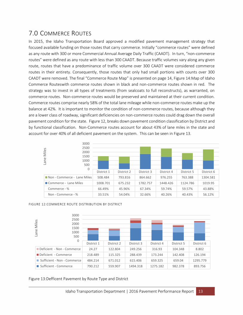
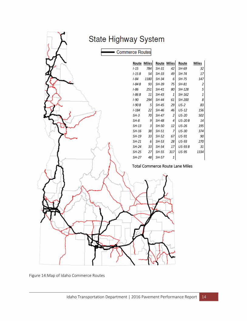
7.0 COMMERCE ROUTES In 2015, the Idaho Transportation Board approved a modified pavement management strategy that
focused available funding on those routes that carry commerce. Initially “commerce routes” were defined
as any route with 300 or more Commercial Annual Average Daily Traffic (CAADT). In turn, “non-commerce
routes” were defined as any route with less than 300 CAADT. Because traffic volumes vary along any given
route, routes that have a predominance of traffic volume over 300 CAADT were considered commerce
routes in their entirety. Consequently, those routes that only had small portions with counts over 300
CAADT were removed. The final “Commerce Route Map” is presented on page 14, Figure 14:Map of Idaho
Commerce Routeswith commerce routes shown in black and non-commerce routes shown in red. The
strategy was to invest in all types of treatments (from sealcoats to full reconstructs), as warranted, on
commerce routes. Non-commerce routes would be preserved and maintained at their current condition.
Commerce routes comprise nearly 58% of the total lane mileage while non-commerce routes make up the
balance at 42%. It is important to monitor the condition of non-commerce routes, because although they
are a lower class of roadway, significant deficiencies on non-commerce routes could drag down the overall
pavement condition for the state. Figure 12, breaks down pavement condition classification by District and
by functional classification. Non-Commerce routes account for about 43% of lane miles in the state and
account for over 40% of all deficient pavement on the system. This can be seen in Figure 13.
FIGURE 12:COMMERCE ROUTE DISTRIBUTION BY DISTRICT
Figure 13:Defficent Pavement by Route Type and District
District 1 District 2 District 3 District 4 District 5 District 6
Non - Commerce - Lane Miles 508.484 793.816 864.662 976.255 763.388 1304.581
Commerce - Lane Miles 1008.701 675.232 1782.757 1448.426 1124.786 1019.95
Commerce - % 66.49% 45.96% 67.34% 59.74% 59.57% 43.88%
Non - Commerce - % 33.51% 54.04% 32.66% 40.26% 40.43% 56.12%
0500
10001500200025003000
Lan
e M
iles
District 1 District 2 District 3 District 4 District 5 District 6
Deficient - Non - Commerce 24.27 122.804 249.256 316.93 104.348 8.802
Deficient - Commerce 218.489 115.325 288.439 173.244 142.408 126.194
Sufficient - Non - Commerce 484.214 671.012 615.406 659.325 659.04 1295.779
Sufficient - Commerce 790.212 559.907 1494.318 1275.182 982.378 893.756
0500
10001500200025003000
Lan
e M
iles
Idaho Transportation Department | 2016 Pavement Performance Report 14
Figure 14:Map of Idaho Commerce Routes
Route Miles Route Miles Route Miles
I-15 784 SH-31 42 SH-69 32
I-15 B 54 SH-33 49 SH-74 17
I-84 1180 SH-34 6 SH-75 147
I-84 B 93 SH-39 75 SH-81 2
I-86 251 SH-41 80 SH-128 5
I-86 B 11 SH-43 1 SH-162 1
I-90 294 SH-44 61 SH-200 8
I-90 B 5 SH-45 29 US-2 83
I-184 22 SH-46 46 US-12 156
SH-3 70 SH-47 2 US-20 502
SH-8 9 SH-48 4 US-20 B 14
SH-13 3 SH-50 12 US-26 195
SH-16 38 SH-51 7 US-30 374
SH-19 33 SH-52 67 US-91 90
SH-21 6 SH-53 28 US-93 270
SH-24 33 SH-54 17 US-93 B 31
SH-25 27 SH-55 317 US-95 1334
SH-27 48 SH-57 1
7066Total MilesTotal Commerce Route Lane Miles
7,066
Idaho Transportation Department | 2016 Pavement Performance Report 15
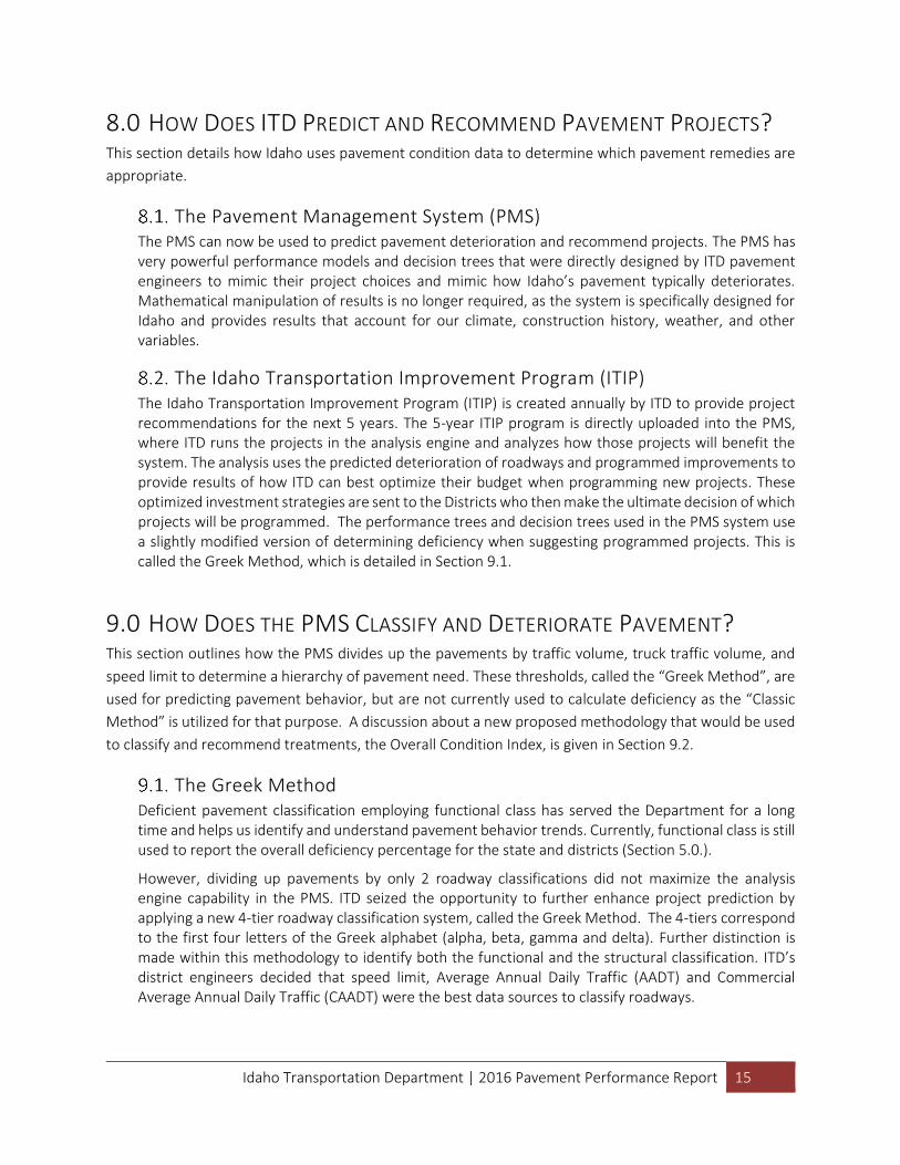
8.0 HOW DOES ITD PREDICT AND RECOMMEND PAVEMENT PROJECTS? This section details how Idaho uses pavement condition data to determine which pavement remedies are
appropriate.
The Pavement Management System (PMS) The PMS can now be used to predict pavement deterioration and recommend projects. The PMS has very powerful performance models and decision trees that were directly designed by ITD pavement engineers to mimic their project choices and mimic how Idaho’s pavement typically deteriorates. Mathematical manipulation of results is no longer required, as the system is specifically designed for Idaho and provides results that account for our climate, construction history, weather, and other variables.
The Idaho Transportation Improvement Program (ITIP) The Idaho Transportation Improvement Program (ITIP) is created annually by ITD to provide project recommendations for the next 5 years. The 5-year ITIP program is directly uploaded into the PMS, where ITD runs the projects in the analysis engine and analyzes how those projects will benefit the system. The analysis uses the predicted deterioration of roadways and programmed improvements to provide results of how ITD can best optimize their budget when programming new projects. These optimized investment strategies are sent to the Districts who then make the ultimate decision of which projects will be programmed. The performance trees and decision trees used in the PMS system use a slightly modified version of determining deficiency when suggesting programmed projects. This is called the Greek Method, which is detailed in Section 9.1.
9.0 HOW DOES THE PMS CLASSIFY AND DETERIORATE PAVEMENT? This section outlines how the PMS divides up the pavements by traffic volume, truck traffic volume, and
speed limit to determine a hierarchy of pavement need. These thresholds, called the “Greek Method”, are
used for predicting pavement behavior, but are not currently used to calculate deficiency as the “Classic
Method” is utilized for that purpose. A discussion about a new proposed methodology that would be used
to classify and recommend treatments, the Overall Condition Index, is given in Section 9.2.
The Greek Method Deficient pavement classification employing functional class has served the Department for a long time and helps us identify and understand pavement behavior trends. Currently, functional class is still used to report the overall deficiency percentage for the state and districts (Section 5.0.).
However, dividing up pavements by only 2 roadway classifications did not maximize the analysis engine capability in the PMS. ITD seized the opportunity to further enhance project prediction by applying a new 4-tier roadway classification system, called the Greek Method. The 4-tiers correspond to the first four letters of the Greek alphabet (alpha, beta, gamma and delta). Further distinction is made within this methodology to identify both the functional and the structural classification. ITD’s district engineers decided that speed limit, Average Annual Daily Traffic (AADT) and Commercial Average Annual Daily Traffic (CAADT) were the best data sources to classify roadways.
Idaho Transportation Department | 2016 Pavement Performance Report 16
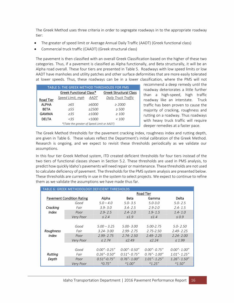
The Greek Method uses three criteria in order to segregate roadways in to the appropriate roadway tier:
The greater of speed limit or Average Annual Daily Traffic (AADT) (Greek functional class)
Commercial truck traffic (CAADT) (Greek structural class)
The pavement is then classified with an overall Greek Classification based on the higher of these two categories. Thus, if a pavement is classified as Alpha functionally, and Beta structurally, it will be an Alpha road overall. These four tiers are presented in Table 5. Roadways with low speed limits or low AADT have manholes and utility patches and other surface deformities that are more easily tolerated at lower speeds. Thus, these roadways can be in a lower classification, where the PMS will not
recommend a deep remedy until the roadway deteriorates a little further than a high-speed, high traffic roadway like an interstate. Truck traffic has been proven to cause the majority of cracking, roughness and rutting on a roadway. Thus roadways with heavy truck traffic will require deeper remedies at a faster pace.
The Greek Method thresholds for the pavement cracking index, roughness index and rutting depth, are given in Table 6. These values reflect the Department’s initial calibration of the Greek Method. Research is ongoing, and we expect to revisit these thresholds periodically as we validate our assumptions.
In this four tier Greek Method system, ITD created deficient thresholds for four tiers instead of the two tiers of functional classes shown in Section 5.2. These thresholds are used in PMS analysis, to predict how quickly Idaho’s pavements will need repair or maintenance. These thresholds are not used to calculate deficiency of pavement. The thresholds for the PMS system analysis are presented below. These thresholds are currently in use in the system to select projects. We expect to continue to refine them as we validate the assumptions we have made thus far.
TABLE 6: GREEK METHODOLOGY DEFICIENT THRESHOLDS
Pavement Condition Rating Road Tier
Alpha Beta Gamma Delta
Cracking Index
Good 5.0 – 4.0 5.0- 3.5 5.0-3.0 5.0- 2.5 Fair 3.9- 3.0 3.4- 2.5 2.9-2.0 2.4- 1.5 Poor 2.9- 2.5 2.4- 2.0 1.9- 1.5 1.4- 1.0
Very Poor ≤ 2.4 ≤1.9 ≤1.4 ≤ 0.9
Roughness Index
Good 5.00 – 3.25 5.00- 3.00 5.00-2.75 5.0- 2.50 Fair 3.24- 3.00 2.99- 2.75 2.75-2.50 2.49- 2.25 Poor 2.99- 2.75 2.74- 2.50 2.49- 2.25 2.24- 2.00
Very Poor ≤ 2.74 ≤2.49 ≤2.24 ≤ 1.99
Rutting Depth
Good 0.00”- 0.25” 0.00”- 0.50” 0.00”- 0.75” 0.00”- 1.00” Fair 0.26”- 0.50” 0.51”- 0.75” 0.76”- 1.00” 1.01”- 1.25” Poor 0.51”-0.75” 0.76”- 1.00” 1.01”- 1.25” 1.26”- 1.50”
Very Poor ˃0.75” ˃1.00” ˃1.25” ˃1.50”
TABLE 5: THE GREEK METHOD THRESHOLDS FOR PMS
Road Tier
Greek Functional Class* Greek Structural Class
Speed Limit, mph AADT Daily Truck Traffic
ALPHA ≥65 ≥6000 ≥ 2000 BETA ≥55 ≥2500 ≥ 500
GAMMA ≥35 ≥1000 ≥ 100
DELTA <35 <1000 < 100 *(Take the greater of Speed Limit or AADT)
Idaho Transportation Department | 2016 Pavement Performance Report 17
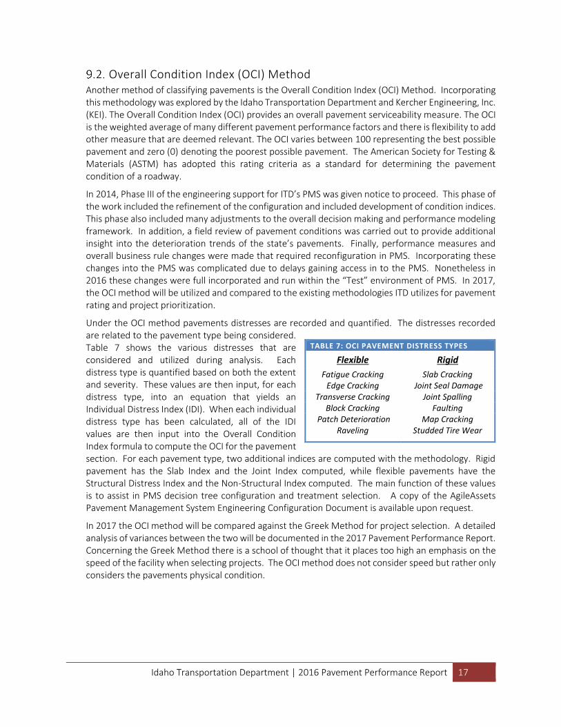
Overall Condition Index (OCI) Method Another method of classifying pavements is the Overall Condition Index (OCI) Method. Incorporating this methodology was explored by the Idaho Transportation Department and Kercher Engineering, Inc. (KEI). The Overall Condition Index (OCI) provides an overall pavement serviceability measure. The OCI is the weighted average of many different pavement performance factors and there is flexibility to add other measure that are deemed relevant. The OCI varies between 100 representing the best possible pavement and zero (0) denoting the poorest possible pavement. The American Society for Testing & Materials (ASTM) has adopted this rating criteria as a standard for determining the pavement condition of a roadway.
In 2014, Phase III of the engineering support for ITD’s PMS was given notice to proceed. This phase of the work included the refinement of the configuration and included development of condition indices. This phase also included many adjustments to the overall decision making and performance modeling framework. In addition, a field review of pavement conditions was carried out to provide additional insight into the deterioration trends of the state’s pavements. Finally, performance measures and overall business rule changes were made that required reconfiguration in PMS. Incorporating these changes into the PMS was complicated due to delays gaining access in to the PMS. Nonetheless in 2016 these changes were full incorporated and run within the “Test” environment of PMS. In 2017, the OCI method will be utilized and compared to the existing methodologies ITD utilizes for pavement rating and project prioritization.
Under the OCI method pavements distresses are recorded and quantified. The distresses recorded are related to the pavement type being considered. Table 7 shows the various distresses that are considered and utilized during analysis. Each distress type is quantified based on both the extent and severity. These values are then input, for each distress type, into an equation that yields an Individual Distress Index (IDI). When each individual distress type has been calculated, all of the IDI values are then input into the Overall Condition Index formula to compute the OCI for the pavement section. For each pavement type, two additional indices are computed with the methodology. Rigid pavement has the Slab Index and the Joint Index computed, while flexible pavements have the Structural Distress Index and the Non-Structural Index computed. The main function of these values is to assist in PMS decision tree configuration and treatment selection. A copy of the AgileAssets Pavement Management System Engineering Configuration Document is available upon request.
In 2017 the OCI method will be compared against the Greek Method for project selection. A detailed analysis of variances between the two will be documented in the 2017 Pavement Performance Report. Concerning the Greek Method there is a school of thought that it places too high an emphasis on the speed of the facility when selecting projects. The OCI method does not consider speed but rather only considers the pavements physical condition.
TABLE 7: OCI PAVEMENT DISTRESS TYPES
Flexible Rigid
Fatigue Cracking Slab Cracking Edge Cracking Joint Seal Damage
Transverse Cracking Joint Spalling Block Cracking Faulting
Patch Deterioration Map Cracking Raveling Studded Tire Wear
Idaho Transportation Department | 2016 Pavement Performance Report 18
10.0 CONCLUSION Based on the pavement data collected during the summer of 2016, ITD is maintain pavement sufficiency at
85% which is about the target of 80%. New equipment and processes will be evaluated during 2017 that
will improve data collection efficiency and analysis.
We hope that you have found the information in this report useful and informative. If you have suggestions
for additional information you would like to see presented in this report, please contact the Asset
Management Engineer at ITD using the contact information on the cover page of this report.