hydrographic control measurements of sediment in the … · hydrographic control measurements of...
TRANSCRIPT
Hydrographic Control Measurements of Sediment in the Accumulation Basin of the HPP Salakovac using Multibeam EchosounderBosko PRIBICEVIC, Almin DAPO , Branko KORDIC, Croatia
University of Zagreb, Faculty of Geodesy
FIG Congress 2014Engaging the Challenges, Enhancing the RelevanceKuala Lumpur, Malaysia, 16 – 21 June 2014
Introduction
� This paper describes the work of hydrographic surveying reservoir basin Hydro Power Plant "Salakovac" for control measurements of sediment.
� It was necessary to conduct hydrographic survey of the bottom of the reservoir and the coast from the HPP Grabovica to HPP Salakovac in total length of about 25 km, and the tributaries.
� The average width of the accumulation basin is 150 meters, with depths up to 47 m and the flow rate at the HPP Salakovac up to 860m3/s.
� Last survey of the HPP Salakovac basin was done prior to the building of the dam of HPP Salakovac in 1969 with 47 cross sections and and in 1977 the tributary Drezanka, which is errosioanally active and the main sediment supplier to the basin, was surveyed with additional 35 cross sections.
XXV International Federation of Surveyors Congress, Kuala Lumpur,
Malaysia, 16 – 21 June 2014
Introduction
� The initial survey of the accumulation basin consisted of the 82 cross sections of the river Neretva canyon.
� The new survey needs to establish the 3D model of the current situation of the accumulation basin and to compare with the initial survey in order to determine the difference.
� Hydrographic survey performed by the Faculty of Geodesy, University of Zagreb.
� For hydrographic survey multibeam echosounder Odom ES3-M was used.
� Measurements performed by the multibeam echosounder are to be compared to the initial survey done before the establishment of the accumulation basin and should be used to create the recent model of the accumulation and as control measurement of the sediment in the accumulation.
XXV International Federation of Surveyors Congress, Kuala Lumpur,
Malaysia, 16 – 21 June 2014
Introduction
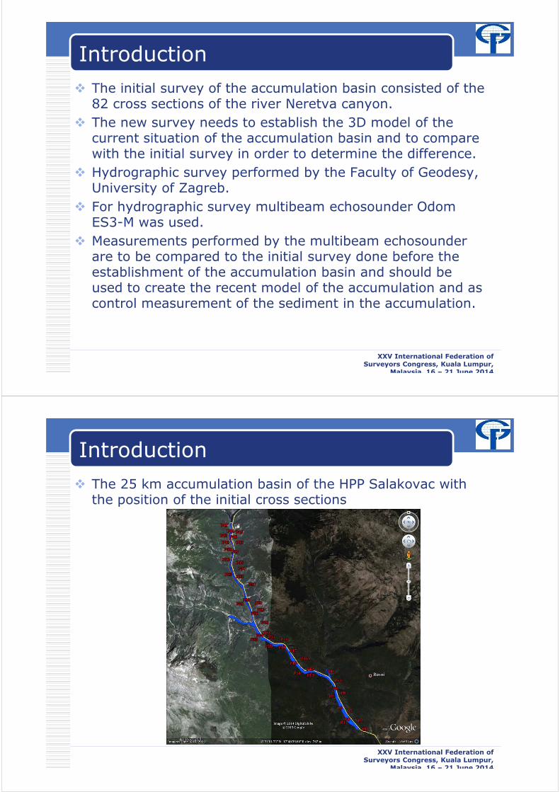
� The 25 km accumulation basin of the HPP Salakovac with the position of the initial cross sections
XXV International Federation of Surveyors Congress, Kuala Lumpur,
Malaysia, 16 – 21 June 2014

Multibeam Measurement in the Accumulation Basin
� For hydrographic survey multibeam echosounder ES3M Odom with TSS DMS 25 motion sensor and heading sensor 100 Hemisphere was used, and Trimble R8 GNSS RTK was used as a positioning device.
� The main characteristics of this system are the compactness and functionality that allow it to be installed on a small boat.
� This is made possible by setting up complete system on a common adapter, which allowed removing the error of determining the offset between the individual sensors.
XXV International Federation of Surveyors Congress, Kuala Lumpur,
Malaysia, 16 – 21 June 2014
Multibeam Measurement in the Accumulation Basin
� Field measurements were carried out in the period 23.-26. of September 2013.
� The system is installed on the ship to maintain accumulation basin obtained from HPP and the system was calibrated performing the patch test prior to the measurement
� During measurements, areas designated for fish farming were bypassed, and areas that are shallow to measure with multibeam
� Three days of survey was necessary to cover the basin.
XXV International Federation of Surveyors Congress, Kuala Lumpur,
Malaysia, 16 – 21 June 2014

Analysis and Results
� Analysis of the data was conducted using HypackMax-Hysweep software.
� Processed and cleaned data was exported and the 3D model of the accumulation basin was created using Autodesk Civil 3D
XXV International Federation of Surveyors Congress, Kuala Lumpur,
Malaysia, 16 – 21 June 2014
Analysis and Results
� Survey measurements form 1969 in the form of the 82 cross sections were digitized in the Civil 3D and compared to the new cross sections created from the new model of the basin which was created from multibeam measurements.
� The figure shows the scanned images of the surveyed cross sections of the accumulation basin from 1969
XXV International Federation of Surveyors Congress, Kuala Lumpur,
Malaysia, 16 – 21 June 2014
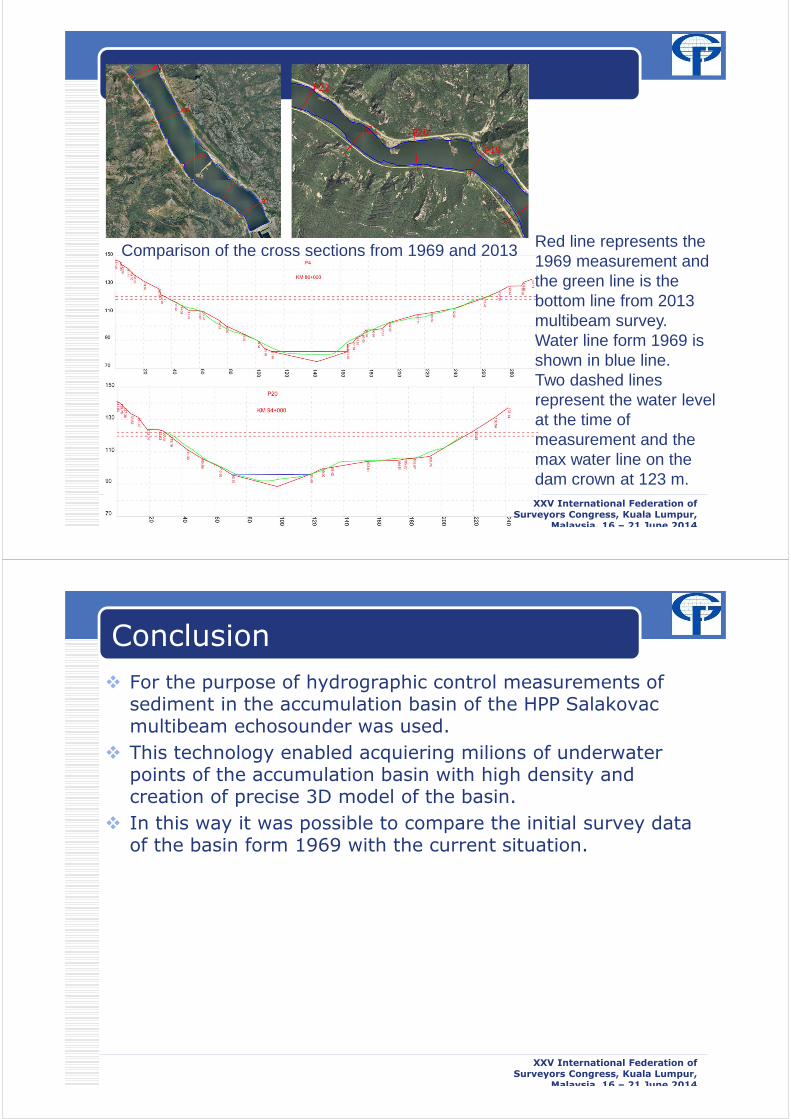
Comparison of the cross sections from 1969 and 2013 Red line represents the 1969 measurement and the green line is the bottom line from 2013 multibeam survey. Water line form 1969 is shown in blue line. Two dashed lines represent the water level at the time of measurement and the max water line on the dam crown at 123 m.XXV International Federation of
Surveyors Congress, Kuala Lumpur, Malaysia, 16 – 21 June 2014
Conclusion
� For the purpose of hydrographic control measurements of sediment in the accumulation basin of the HPP Salakovac multibeam echosounder was used.
� This technology enabled acquiering milions of underwater points of the accumulation basin with high density and creation of precise 3D model of the basin.
� In this way it was possible to compare the initial survey data of the basin form 1969 with the current situation.
XXV International Federation of Surveyors Congress, Kuala Lumpur,
Malaysia, 16 – 21 June 2014

Conclusion
� The results presented in this paper clearly show the difference between the two. The bottom line is now much smoother due to 40 years of river flow and layer of sediment on the bottom which can be recognized form the survey comparison between 1969 and 2013.
� The results are yet to be confirmed by subbottom profiling which is scheduled to take place in near future.
� 3D model of the accumulation basin of the HPP Salakovac created from the multibeam measurement will now serve as the reference for future control measurements.
XXV International Federation of Surveyors Congress, Kuala Lumpur,
Malaysia, 16 – 21 June 2014
�Thank you
�Questions
XXV International Federation of Surveyors Congress, Kuala Lumpur,
Malaysia, 16 – 21 June 2014