hydrocarbon contamination of groundwater in kuwait …hasche/s_grundwasserschutz/paper_gws_a… ·...
TRANSCRIPT

Hydrocarbon Contamination of Groundwater in Kuwait due to the Gulf War
Anja Bretzler
4th year Environmental Science (Geoecology) Faculty for Geosciences and MiningFreiberg University of Mining and Technology
Abstract. The Gulf War of 1990/1991 has had major environmental consequences
for the small country of Kuwait. Large-scale oil spills and combustion products
from burning oil wells have contaminated extensive areas of desert soil. Especially
at risk from hydrocarbon contamination are Kuwait’s scarce groundwater
resources. Most aquifers carry brackish to highly saline groundwater, with only
two small regions where freshwater lenses exist. Contamination of groundwater
can occur either by direct infiltration of oil from oil lakes or by hydrocarbon
transport with infiltrating rainwater. Changes in the composition of crude oil as it
undergoes weathering have to be considered when predicting and/or modelling
groundwater pollution.
Hydrogeological Situation of Kuwait
Kuwait is a small country located at the north-eastern edge of the Arabian Peninsula, bordered by the Arabian Gulf to the east, Saudi Arabia to the south and Iraq to the north and west (Al-Sulaimi et al. 1993). Average annual rainfall is about 110 mm and occurs mainly from November to April. The annual variability ranges from a low of 31 mm to a high of 242 mm (Fadlelmawla and Al-Otaibi 2005). In these arid conditions, natural water resources are limited.
The main aquifer system of Kuwait is composed of two major formations, namely the Kuwait Group aquifers and the Damman formation. The lithologies of the Kuwait group aquifers are dominated by conglomeratic sand and gravel, as well as calcareous sandstone and shale. The Damman Formation consists of limestone and dolomite, reaching thicknesses of up to 200 m (Fig. 1).

2 Anja Bretzler
Fig.1. Lithostratigraphy of Kuwait’s aquifer system (Source: Al-Sulaimi et al. 1993)
Groundwater quality ranges from mostly brackish to highly saline, with maximum TDS levels of up to 200,000 ppm (Al-Rashed et al. 1998). Only at two locations in the northern part of the country, Raudhatain and Umm Al-Aish, do isolated freshwater lenses occur (Fig. 2). Geomorphologically, these two areas are characterised by drainage basins with large catchment areas. After occasional rainfall, playa lakes form at the lowest point of the basin and result in groundwater recharge. At Raudhatain, usable groundwater with TDS <1000 mg/L occurs in saturated sandstone beds at a depth of 20 – 25 m from ground surface and at Umm

Hydrocarbon Contamination of Groundwater in Kuwait due to the Gulf War 3
Al-Aish in depths of 17 – 23 m. With increasing depth, the water becomes more mineralized (Al-Sulaimi et al. 1993).
To conserve and protect these valuable water resources, only limited amounts of water are extracted from the freshwater lenses and bottled for drinking purposes. Only 5% of Kuwait’s drinking water demand is covered in this way. The rest comes from desalinised seawater and brackish groundwater mixed with distilled water to lower the salinity (Fadlelmawla and Al-Otaibi 2005).
The groundwater fields of Kuwait are shown in Figure 2. Large amounts of brackish groundwater are extracted for irrigation and domestic purposes from the fields located in the centre and south of the country. This has led to a rapid decline of groundwater levels and a deterioration of water quality (Al-Rashed et al. 1998).
Fig. 2. Location of groundwater fields in Kuwait (Source: Al-Rashed et al. 1998)
Oil Spills of the Gulf War
The Gulf War of 1990/1991 had major environmental consequences. The Iraqi invasion of Kuwait, followed by a defeat of Iraqi troops by coalition forces, led
4 Anja Bretzler
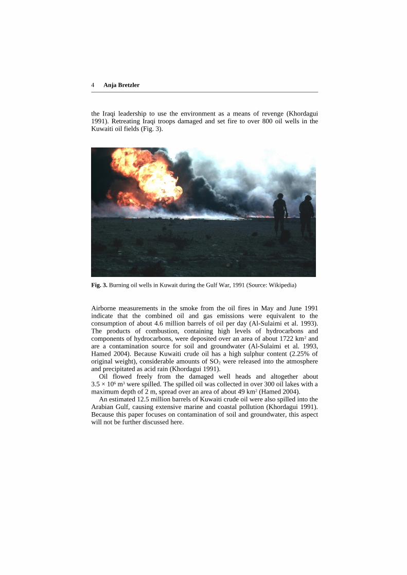
the Iraqi leadership to use the environment as a means of revenge (Khordagui 1991). Retreating Iraqi troops damaged and set fire to over 800 oil wells in the Kuwaiti oil fields (Fig. 3).
Fig. 3. Burning oil wells in Kuwait during the Gulf War, 1991 (Source: Wikipedia)
Airborne measurements in the smoke from the oil fires in May and June 1991 indicate that the combined oil and gas emissions were equivalent to the consumption of about 4.6 million barrels of oil per day (Al-Sulaimi et al. 1993). The products of combustion, containing high levels of hydrocarbons and components of hydrocarbons, were deposited over an area of about 1722 km2 and are a contamination source for soil and groundwater (Al-Sulaimi et al. 1993, Hamed 2004). Because Kuwaiti crude oil has a high sulphur content (2.25% of original weight), considerable amounts of SO2 were released into the atmosphere and precipitated as acid rain (Khordagui 1991).
Oil flowed freely from the damaged well heads and altogether about 3.5 × 10⁶ m3 were spilled. The spilled oil was collected in over 300 oil lakes with a maximum depth of 2 m, spread over an area of about 49 km2 (Hamed 2004).
An estimated 12.5 million barrels of Kuwaiti crude oil were also spilled into the Arabian Gulf, causing extensive marine and coastal pollution (Khordagui 1991). Because this paper focuses on contamination of soil and groundwater, this aspect will not be further discussed here.

Hydrocarbon Contamination of Groundwater in Kuwait due to the Gulf War 5
Components of Crude Oil
Crude oil is a complex mixture of hydrocarbons, ranging from volatile compounds such as methane to highly persistent and viscous long-chain hydrocarbons. The main components are saturated alkanes, but aromatic hydrocarbons can also be contained in considerable amounts. Because of its formation from biomass, compounds containing nitrogen (e.g. pyrrole, pyridine) and sulphur (e.g. thiophenol, benzothiophen) are also incorporated in the mixture (Alloway and Ayres 1996).
Of particular environmental concern is the natural existence of polycyclic aromatic hydrocarbons (PAH) in crude oil. Furthermore, these substances are formed during combustion of fossil fuels, as was the case during the Kuwaiti oil well fires. Several PAH, such as benzo[a]pyrene have highly toxic and carcinogenic properties and cause severe pollution when they reach the groundwater (Alloway and Ayres 1996).
Crude oil that is exposed to air and/or water comes under the influence of weathering. Processes such as the evaporation of light components, photo-oxidation, emulsification and microbial decomposition result in changed properties of the oil as a function of time (Hamed 2004).
Contamination Potential of Groundwater by Hydrocarbons
The extensive area covered by surface contamination due to oil lakes and products of combustion from oil fires is presented in Figure 4. Notable is the contaminated topsoil of Raudhatain and Umm Al-Aish, the regions containing Kuwait’s only fresh groundwater.

6 Anja Bretzler
Fig. 4. Location of hydrocarbon surface contamination after the Gulf War (Source: Al-Sulaimi et al. 1993)
Groundwater pollution can result from any of the following mechanisms (Al-Sulaimi et al. 1993):
1. Direct infiltration of oil from oil lakes.2. Infiltrating rainwater can leach some of the products of combustion
deposited on the ground surface.3. Subsurface leakage of oil from damaged oil well casings.
The first two points will be discussed in more detail on the following pages.

Hydrocarbon Contamination of Groundwater in Kuwait due to the Gulf War 7
Direct infiltration of oil from oil lakes
The movement of hydrocarbons through the unsaturated zone is a complex process, especially as the composition of the infiltrating crude oil changes over time as it undergoes weathering. Factors influencing whether the hydrocarbons will reach the groundwater include vertical hydraulic conductivity, oil dynamic viscosity and the groundwater recharge rate (Hamed 2004). The transport of Non-Aqueous Phase Liquids (NAPL) from the surface to the groundwater table (fresh water lenses at Raudhatain and Umm Al-Aish) was modelled by Hamed (2004) using the semi-analytical Hydrocarbon Spill Screening Model (HSSM). Results showed that the hydrocarbons would not reach the groundwater in the next 100 years. As the residual oil in the oil lakes is subjected to weathering, making it more viscous, the possibility of water table impact is further reduced.
Similar results were obtained by Al-Sulaimi et al. (1993), who predicted that oil infiltration beneath oil lakes will be limited to 2 m below ground surface. These predictions were mainly based on mathematical models and laboratory experiments.
Analyses of Total Petroleum Hydrocarbons (TPH) of samples collected from soil profiles in contact with oil lakes show that to depths of 1 - 1.5 m, the soils are highly contaminated. TPH levels of up to 20,000 µg/g were measured, with natural background levels being 20 – 30 µg/g. In greater depths, the TPH concentrations slowly return to background levels (Al-Sarawi et al. 1998).
Leaching of hydrocarbons by infiltrating rainwater
Even though the mean annual rainfall in Kuwait is very low, high intensity rainfall events can occur. In history, precipitation amounts of 40 mm in 15 – 30 min were recorded (Al-Sulaimi et al. 1993). Such high-intensity rainfall events generate a considerable amount of surface runoff, which is able to transport and partially dissolve combustion products of oil fires deposited on the soil. In the large drainage basins of Raudathain and Umm Al-Aish, this effect is especially pronounced. The runoff water forms freshwater pools at the lowest point of the watershed and subsequently infiltrates into the soil. Al-Sulaimi et al. (1993) measured infiltration rates at several locations at Raudhatain and Umm Al-Aish using a double-ring infiltrometer. Results showed great variations in the infiltration rates, which ranged from 4 to 67 cm/h. Hamed (2004) mentions infiltration rates of 10 – 40 cm/h in the dry season (April to October) and 5 – 30 cm/h in the rainy season (November to March). At these rates, rainwater will take between 1 and 20 days to penetrate to a depth of 20 m and reach the water table. Hence, it is possible for rainwater to leach some of the contaminants from the ground surface or within the unsaturated zone and reach the groundwater within a short period of time. The critical aspect in order to reach these high infiltration rates is the correct type of rainfall, meaning high intensity over a short time period. Average, low-intensity rainfall spread over longer periods will not have a significant impact on groundwater contamination because infiltration will be limited (Al-Sulaimi et al. 1993).

8 Anja Bretzler
Leaching experiments in the laboratory to characterize the mobilization of hydrocarbon pollutants from the soil were carried out by Literathy et al. (2003). Oily soil samples were repeatedly rinsed with distilled water, followed by the analysis of hydrocarbons in the leachate. Especially PAH compounds tended to accumulate in the leachate, pointing to the possibility of groundwater contamination through these substances. It has to be mentioned though, that the transferability of these laboratory experiments to real conditions in the field is limited.
Conclusion
The widespread pollution of Kuwait’s desert environment as a result of oil well fires and oil lakes poses a real threat to the country’s scarce groundwater resources. Even though 95% of the spilled oil was reclaimed after the Gulf War, extensive areas of highly contaminated soils remain (Hamed 2004). Despite preliminary modeling results showing that the vertical transport of the accumulated oil on the ground surface through the unsaturated zone as a separate oil phase is unlikely (Hamed 2004), several limitations to this theory have to be considered:
1. The weathering of crude oil, as well as the nature and mobility of its decomposition products is complex and not very well understood.
2. High-intensity rainfall events, even though rare, can generate high amounts of runoff and subsequent infiltration to the water table, carrying with it contamination from the ground surface.
3. Hydrocarbon contamination may not only originate from the surface. Damaged oil well casings can result in direct seepage of oil to the subsurface soil or groundwater.
Groundwater samples collected from areas adjacent to oil spills by Al-Sulaimi et al. in 1992 have already indicated minor hydrocarbon pollution. In addition to further research on hydrocarbon contamination and transport, a continual long-term monitoring program of Kuwaiti groundwater is needed to assess the likely slow downward migration of polluting substances (Literathy et al. 2003).
References
Alloway BJ, Ayres DC (1996) Schadstoffe in der Umwelt. Spektrum, HeidelbergAl-Rashed M, Al-Senafy MN, Viswanathan MN, Al-Sumait A (1998) Groundwater Utiliz
ation in Kuwait: Some Problems and Solutions. Water Resources Development 14: 91-105
Al-Sarawi M, Massoud MS, Al-Abdali F (1998) Preliminary assessment of oil contamination levels in soils contaminated with oil lakes in the Greater Burgan Oil Fields, Kuwait. Water, Air and Soil Pollution 106: 493-504

Hydrocarbon Contamination of Groundwater in Kuwait due to the Gulf War 9
Al-Sulaimi J, Viswanathan MN, Székely F (1993) Effect of oil pollution on fresh groundwater in Kuwait. Environmental Geology 22: 246-256
Fadlelmawla A, Al-Otaibi M (2005) Analysis of the Water Resources Status in Kuwait. Water Resources Management 19: 555-570
Hamed MM (2004) Screening level modeling of long-term impact of petroleum hydrocarbon contamination on fresh groundwater lenses in the Arabian Gulf Region. Environmental Modeling and Assessment 9: 253-264
Khordagui H (1991) Comments on Current Environmental Events in Kuwait. Environmental Management 15: 455-459
Literathy P, Quinn M, Al-Rashed M (2003) Pollution potential of oil-contaminated soil on groundwater resources in Kuwait. Water Science and Technology 47: 259-265
Wikipedia: http://en.wikipedia.org/wiki/Kuwaiti_oil_fires