housing in south africa
TRANSCRIPT
H O U S I N G IN S O U T H AFRICA
Linking Form to Delivery Process
GLEN MILLS
INTRODUCTION
This paper presents a preliminary model which attempts to link the built form of housing systematically to the delivery process, tt is de termined by a broad interpretation of:
�9 the delivery procedure;
�9 elementary shapes of built form;
�9 the urban spatial f ramework in which housing is situated.
Al though provisional, this model suggests one way of synthesising product with process and end with means. It is a synoptic framework, the intention of which is to identify and clarify a key issue affecting the development of housing policy: the relationship between the delivery process and housing design.
A fundamenta l assumption that underlies the argument in this paper is that the deliberations toward a new housing policy in South Africa tend to focus almost exclusively on delivery procedures at the expense of a comprehensive treatment of physical form. Yet as is apparent in different kinds of housing layout, from irregularly shaped informal settlements to the more orthogonal townships and site-and-service schemes, different delivery systems seem to give rise to certain kinds of form. The implications this relationship has for hous ing policy are vast and challenging. The purpose of this paper is to propose a f ramework through which delivery options may be tied to built forms.
At stake is not only the statistical issue of meet ing an enormous house product ion target, but also a concern for the social and physical quality of life in the housing environment. Given South Africa's heterogeneous popula t ion there would appear to be little value in specifying a 'good ' housing solution. What is necessary is a bold, creative vision based on des ign/de l ivery principles
56 U R B A N F O R U M 4:2, 1993
which can be adapted and realised in different socio-economic, political and physical contexts. In this way local needs can be accommodated in terms of national concerns.
This blend of a global vision and local flexibility creates a f ramework for evading socio-economic and physical problems associated with housing layout. Of these one of the most striking is the urban sprawl characteristic of townships, suburbia and, more recently, site-and-service shacklands. A significant feature of this landscape is that the proport ion of housing to open space is roughly 1:10 (Senior et al. 1987). This is in stark contrast to the proport ion of 1:3 found in an example of informal settlement layout (Figure 1). In this regard it is worth noting that while there are distinct problems associated with informal settlements from the point of view of economy of layout, construction and user control, they seem to be more agreeable than the township design.
It would appear that the township in its present form no longer has general value for housing the poor in South Africa. To continue to prescribe it would highlight its unacceptabili ty on several levels:
�9 politically (it is widely regarded as an imposit ion by the state, which has used it as a controlling mechanism);
�9 socially (both residents and outsiders experience it as a sterile, anti-social and dangerous environment);
�9 architecturally (urban designers and architects find little scope within the regulations governing its layout to make a meaningful contribution through design effort);
,, morphologically (it is spatially fragmented and segregated, leading to high infrastructural costs and a heightened potential for crime).
The township is clearly the result of a product-driven policy in which there is little (if any) concern for procedural matters where these affect the end-users. Likewise, any new policy that might be process-driven in an attempt to overcome the shortcomings of the past runs the risk of perpetuat ing the same problems of sprawl and unacceptable environment, as is already evident in site-and-service schemes. Of note here is the immense emphasis currently being placed on the site-and-service solution by influential institutions such as the Independen t Development Trust, the Urban Foundation and the Development Bank of Southern Africa (see also De Loor 1992).
A new approach to policy formulation is needed in which there is a calculated relationship between the two essential ingredients: delivery process and housing product . Such a policy might be regarded as a ' system' in which the static component of built form cannot be regarded in isolation from the dynamic process of procurement, and vice versa (cf.,Hawkes 1973). Its success will depend not only on the existence of some relationship between the parts, but on the precise nature of that relationship so that a change in one component will have implications throughout the system.

HOUSING IN SOUTH AFRICA 57
+ ,
Figure 1
m . , y
. : !
m
�9 T m
m
u m m
m i + L . .
m L
/
m
THE TOWNSHIP NORM (20 houses per Ha.) 20 Cells 10% Coverage 1:10 Form/Space Ratio
r.'-.'Z_,'l
/u. " rm..'~J ,,. -%,"P, m' I
..==~ ...+ rm_..!_
AN INFORMAL SETTLEMENT (Crossroads, C.T., c.1985) 154 Cells 37% Coverage Say 1:3 Form/Space Ratio
58 URBAN FORUM 4:2, 1993
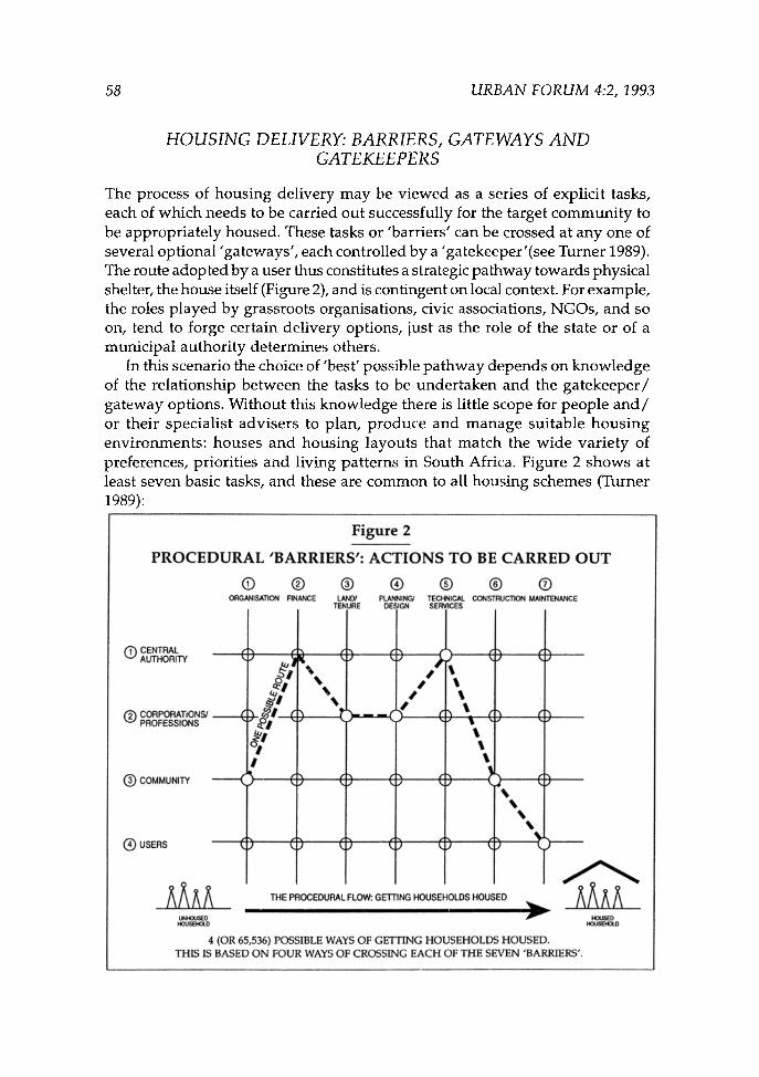
HOUSING DELIVERY: BARRIERS, GATEWAYS AND GATEKEEPERS
The process of housing delivery may be viewed as a series of explicit tasks, each of which needs to be carried out successfully for the target communi ty to be appropriately housed. These tasks or 'barriers' can be crossed at any one of several optional "gateways', each controlled by a 'gatekeeper '(see Turner 1989). The route adopted by a user thus constitutes a strategic pathway towards physical shelter, the house itself (Figure 2), and is contingent on local context. For example, the roles played by grassroots organisations, civic associations, NGOs, and so on, tend to forge certain delivery options, just as the role of the state or of a municipal authority determines others.
In this scenario the choice of 'best' possible pa thway depends on knowledge of the relationship between the tasks to be under taken and the ga tekeeper / gateway options. Without this know!edge there is little scope for people a n d / or their specialist advisers to plan, produce and manage suitable hous ing environments: houses and housing layouts that match the wide variety of preferences, priorities and living patterns in South Africa. Figure 2 shows at least seven basic tasks, and these are common to all housing schemes (Turner 1989):
Figure 2
PROCEDURAL 'BARRIERS': ACTIONS TO BE CARRED OUT
| | | | @ | | ORGANISATION FINANCE LAND/ pLANNING/ TECHNICAL CONSTRUCTION MAINTENANCE
TENURE DESIGN SERVICES
(~)CENTRAL AUTHORITY
(~) CORPORATIONS/ PROFESSIONS
(~COMMUNITY
|
AA A
#
g, I
C} (
L
% %
G
) k
) (
I I I
I I I
% t ' ~ �9
(
( ) - -
THE PROCEDURAL FLOW: GETTING HOUSEHOLDS HOUSED
Uh~C~D HOUSEPKY,.D
4 (OR 65,536) POSSIBLE WAYS OF GETTING HOUSEHOLDS HOUSED. THIS IS BASED O N FOUR WAYS OF CROSSING EACH OF THE SEVEN 'BARRIERS'.
HOUSED HC~SEHOLD

HOUSING IN SOUTH AFRICA 59
1. Organisation: management by those on whom the implementation of the scheme depends so as to ensure proper co-ordination.
2. Finance: obtaining the necessary capital for the provision of material resources and services.
3. Land/Tenure~ acquiring land or appropriate forms of tenure in order to secure property and use rights.
4. Planning/Design: technical specification of built forms and layouts that are easily grasped or modified.
5. Technical Services: obtaining the appropriate level of infras t ructura l development.
6. Construction: getting the scheme built. 7. Maintenance: preserving the physical fabric of the scheme in order to safeguard
against its untimely loss.
In terms of this array one of the main objectives of policy would not merely be to assist users across the barriers, but to ensure that the most suitable pathways are chosen. There are essentiallv four options available for carrying out each specific task:
�9 Centralised Authority: the government and different forms of local authority. �9 Corporations/Professions: private sector undertakings, such as building
societies, banks and companies, and professional consultants. �9 Community: local, community-based organisations and /o r their advisers and
consultants. �9 Users: the individual dwellers themselves.
Given this pair of sets (activities and actors) there are 65 536 hypothetically possible routes available to users. Obviously some routes will be more practical, attractive or common than others, and selection will vary according to individual circumstances. Consequently, one of the first tasks in the further elaboration of this model will be to investigate and identify how particular routes are linked to circumstances affecting choice, and which procedural patterns are dominant.
ELEMENTARY BUILT FORMS: EVALUATING THE SHAPE OF HOUSING
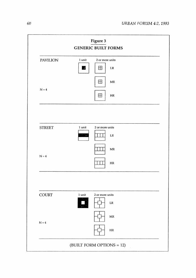
Three generic classes of built form have been identified and applied in architectural and urban studies (Martin and March 1972). These are:
a. Isolated built forms called 'pavilions' (a detached house surrounded by open space on its stand)
b. Isolated open spaces called 'courtyards" (a house built around the perimeter of its stand to surround an open space in the middle)
c. Terraces of built form called 'streets' (houses joined at the sides to form a continuous band).
60 URBAN FORUM 4:2, 1993
Figure 3
GENERIC BUILT FORMS
PAVILION
N = 4
1 unit 2 or more units
STREET
N = 4
I unit 2 or more units
~ LR
COURT
N = 4
1 unit 2 or more units
D ~ LR
(BUILT FORM OPTIONS = 12)
HOUSING IN SOUTH AFRICA 61
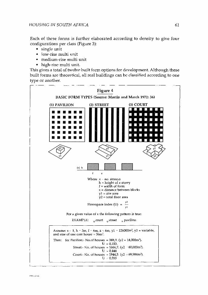
Each of these forms is further elaborated according to densi ty to give four configurations per class (Figure 3):
�9 single unit �9 low-rise multi unit �9 medium-rise multi unit �9 high-rise multi unit.
This gives a total of twelve built form options for development. Al though these built forms are theoretical, all real buildings can be classified according to one type or another.
(1) P A V I L I O N
F i g u r e 4
B A S I C F O R M T Y P E S ( S o u r c e : M a r t i n a n d M a r c h 1 9 7 2 : 36)
(2) S T R E E T (3) C O U R T
m m m m m m
i m | i i !
m m m m m m
m m m m i m
m m m m m m
m i n m m m
�9 , I i i �9 �9 �9 �9 am mia a i i emmm.m.mm �9 �9 H i �9 ' i i nmmmmmmm nTmmm m iN nmm mmm mmm
f z
W h e r e x = no. s t o r e y s h = h e i g h t of a s t o r e y f = w i d t h of f o r m z = d i s t a n c e b e t w e e n b l o c k s y l = s i t e a r e a y2 = to t a l f loor a rea
y2 F l o o r s p a c e i n d e x (U) = - -
yl
For a g i v e n v a l u e of x t he f o l l o w i n g p a t t e r n is t rue :
E X A M P L E : u c o u r t u s t r ee t u p a v i l i o n
A s s u m e : x = 1, h = 3m, f = 6m, z = 6m, y l = 126000m 2, y2 = v a r i a b l e , a n d s i z e of one core h o u s e = 36mL
Then : for P a v i l i o n : - N o . o f h o u s e s = 388,9. (y2 = 14,000m2). U = 0,333.
Street : - No. of h o u s e s = 1666,7. (y2 = 60,000m2). U = 0,444
Cour t : - No. of h o u s e s = 1944,5. (y2 = 69,984m2). U = O,555

62 URBAN FORUM 4:2, 1993
Each of the three classes is therefore an elementary model which can be enumerated to assess performance in terms of land use, bulk, density and height. For example, a comparative analysis of these models shows that if the site area is held constant then the courtyard option yields the most number of houses, followed by the street form, with the pavilion yielding the least number of dwellings (Figure 4). This is a function of the 'floorspace index' which, when applied to finding out which form has the greatest built potential, or is more efficient in terms of a set number of storeys, shows that the courtyard is significantly the best performer and the pavilion the worst.
These studies of form and density illustrate that the architecture of housing sprawl is a derivative of the pavilion model. The authors of housing policy mus t therefore be alert to the practical implications which built form has for urban development .
Figure 5
786,432 Form/Process opt ions are available to individual users. Given the 330,000 houses required each year for the next decade the
"option/space' of 786,432 (2,4) is w i d e for each city of this size. 330,000
(n) PROCEDURAL OPTIONS
I I I I 3 4 5 6 7 8 9 10 11
786,432 FORM/PROCESS OPTIONS
n - 65,536
I 12

HOUSING IN SOUTH AFRICA 63
Although the precise allocation of the generic classes of built form to all delivery routes still needs to be ascertained, what can be determined is the total number of form/del ivery options possible (Figure 5). This is taken as the product of the 12 forms and 65 536 routes, giving 786 432 housing options from which it is possible for users to choose. The significance of this 'populat ion ' of options becomes apparent when seen against the projected 330 000 houses which need to be built each year for the next decade (De Loor 1992). Indeed it is theoretically possible to produce 2,4 such cities in which each individual housing option is unique.
U R B A N SPACE A N D H O U S I N G F O R M
The geometry of built form impacts profoundly on the character of the open space system - the public realm - that defines the neighbourhood and housing district. This is because the area between buildings is shaped according to the manner and extent to which those buildings are brought into relationships with one another. Closely related layouts will tend to be more spatially integrated, while sparse layouts will be more segregated (Mills 1989).
Thus the layout of streets, parks, squares and walkways - a function of the overall allocation of built forms to open space - may be regarded as a 'pat tern ' of interconnected segments (Hillier and Hanson 1984). It is the degree to which this pattern of spatial relations is integrated that determines the physical quality of housing schemes in terms of density, movement and use. Strongly segregated layouts give rise to isolated pockets of unused and under-used areas, and are therefore unsafe, while areas that are spatially integrated are more socially agreeable and economical.
The quantitative measurement of spatial integration is made possible by a suite of powerful computer programs called 'space syntax' (Hillier, Hanson et al. 1983). Pioneered at University College London, it has recently been applied successfully in settlement studies in South Africa (Mills 1992a and 1992b).
In the space syntax model, spatial integration is expressed as a measure of 'Relative Asymmetry ' , or RA, where high values (those that tend towards 1) indicate segregated configurations, and low values (those closer to 0) indicate integrated layouts. This technique is based on theoretic graph conventions in which the syntactical 'depth ' of each segment of open space (individual streets, squares, and so on) is calculated according to its relationship with all the other segments in the layout. What matters here are the connections between the space in question and all the others. Where there are many intervening spaces between a pair of streets the relationship will be deep; where there are few the relationship will be shallow.
Thus a street that displays a high RA value tends to push the rest of the

64 URBAN FORUM 4:2, 1993
settlement away from it, while a low value indicates that the space attracts other spaces to it. Once all segments have been assigned RA values it becomes possible to determine the overall pattern of integration by finding out the Mean RA for the settlement as a whole.
The significance of the integration pattern is that it is a good predictor of movement and use patterns. Studies on existing housing estates and urban areas show powerful correlations between RA values and the concentration of people in space. Segregated layouts tend to be barren, while integrated areas are mostly densely occupied.
When this analysis is applied to the three built forms discussed earlier the result is revealing (Table 1).
TABLE 1. Spatial integration in the elementary built forms illustrated in Figure 4
BUILT FORM MEAN RA Pavilion 0,233
Street 0,210 Courtyard 0,183
Thus, in addition to being a relatively poor performer in terms of its geometry, the pavilion is syntactically weak, displaying a comparatively high degree of spatial segregation. Again, the court performs well in relation to both the street and the pavilion. Since the space syntax technique is able to model the pattern of movement and use as a function of spatial layout it is possible to assume that on a social level the pavilion is potentially more disagreeable than the other forms.
An essential feature of the space syntax model is that it inter-relates all the individual parts of a layout to give a coherent picture of how the complex works as a whole. Since most housing developments occur in existing urban areas an important objective is to integrate the new layout with what is already built. In other words, housing schemes need to fit into urban areas in such a way as to preserve internal integration as well as to ensure that they are not cut off from the wider urban context.
The extent to which this overall pattern of integration will be achieved depends partly on the nature of the urban area in which the development takes place. In this regard the following zones have been identified by the Urban Foundation (1992):
1. Urban periphery 2. Existing suburbs 3. Strategic public/private land 4. Symbolic group areas 5. Transitional areas

HOUSING IN SOUTH AFRICA 65
6. Inner city/CBD 7. Existing townships 8. Existing informal settlements.
This typology represents qualitatively different environments in which the properties of building density and spatial integration vary from zone to zone. Certain zones will therefore be more suitable to particular built form configurations than others, and the determination of this allocation pattern must remain a priority for further research. What is already known, on the basis of completed work, is that problems associated with housing layout arise under certain conditions, such as when:
�9 too much public open space has no direct relation to house entrances; ~ an over-complex layout siphons off, or deters, natural movement from some
areas while allowing access to them; �9 the layout lacks internal integration (it is too strongly broken up into sub-
areas, with no overall coherence); �9 the layout lacks external integration (it is too strongly cut off from the larger
area of which it is a part); �9 the layout lacks intelligibility, both internally and from the outside (it is easy
for users to become disorientated and eventually to get lost) (Hillier and Hanson 1984; cf Dewar et al. 1976 where seemingly similar observations were asserted or implied, but on the basis of a less rigorous, more intuit ive point of view).
The principle design objective is consequently to reconcile the need for priva cy at the level of the individual house with the need for a housing layout that is manifestly public and therefore well used. This reconciliation should be guided by policy so as to ensure a new housing environment that is safe, economical and fully functional on all levels.
C O N C L U S I O N S
This paper has covered much ground; first arguing for the calculated, systematic linking of delivery procedures to built forms, and then presenting an outline model for achieving this objective. Specific tasks necessary for the complet ion of this model were identified.
It was also shown that the link between housing de l ivery /des ign options and the formulat ion of large scale layouts cannot be considered in isolation from the urban grids in which they are situated. The challenge this presents for both the formulation of housing policy and urban development is complex, and in this regard the space syntax technique was briefly shown as one way of rigorously relating layout to functional patterns.
66 URBAN FORUM 4:2, 1993
This challenge highlights a simple fact: the potential for housing policy to impact on the attempts to reconstruct the South African city on social, economic and physical levels cannot be overestimated. What is required is not so much a commitment to this principle by means of a policy statement, but techniques for its realisation through policy. The model presented in this paper, however incomplete it may be, is an attempt to make some contribution to that end.
A C K N O W L E D G E M E N T S
I would like to thank Alan Lipman and Ron Kirby of the University of the Witwatersrand Department of Architecture for the valuable comments they made on an earlier version of this paper.
REFERENCES
De Loor, J.H. 1992. Housing in South Africa. Proposals on a Policy and Strategy. Report by the Task Group on National Housing and Strategy, South African Housing Advisory Council, RP 79/1992: Pretoria.
Dewar, D., Uytenbogaardt, R., Hutton-Squire, M., Levy, C. and Menidis, P. 1976. Housing. A Comparative Evaluation of Urbanism in Cape Town. Cape Town: Urban Problems Research Unit.
Hawkes, D. 1973. Are floors and ceilings really necessary? RIBA Journal October, 498-502.
Hillier, B. and Hanson, J. 1984. The Social Logic of Space. Cambridge: Cambridge University Press.
Hillier, B., Hanson, J., Peponis, J., Hudson, J. and Burdett. 1983. Space Syntax. A different urban perspective. Architect's Journal October, 47-63.
Martin, L. and March, L. (eds.) 1972. Urban Space and Structures. Cambridge: Cambridge University Press.
Mills, G. 1989. The shape of housing in South Africa. Open House International 14(3):6-15.
Mills, G. 1992a. Space and function in small house plans. Environment and Planning B: Planning and Design 19:545-558.
- - 1992b. The spatial structure of ideology in informal settlements. Building and Environment 27(1):13-21.
Senior. B., Wood, E. and Walker, B. 1987. A Housing.Options Assessment Manual. Johannesburg: The Urban Foundation.
Turner, J. 1989. Tools for Building Community. In Wilkinson, N. (ed.) Quality in the Built Environment. Newcastle-upon-Tyne: Urban International Press.
Urban Foundat ion. 1992. Housing Strategy in a Transitional South Africa. Johannesburg: Mimeograph, 14pp.