houseboat guide.qxd: houseboat guide - holly bluff · boat docks. many fish camps have restaurants...
TRANSCRIPT
Cruising Guide &Houseboat Handbook
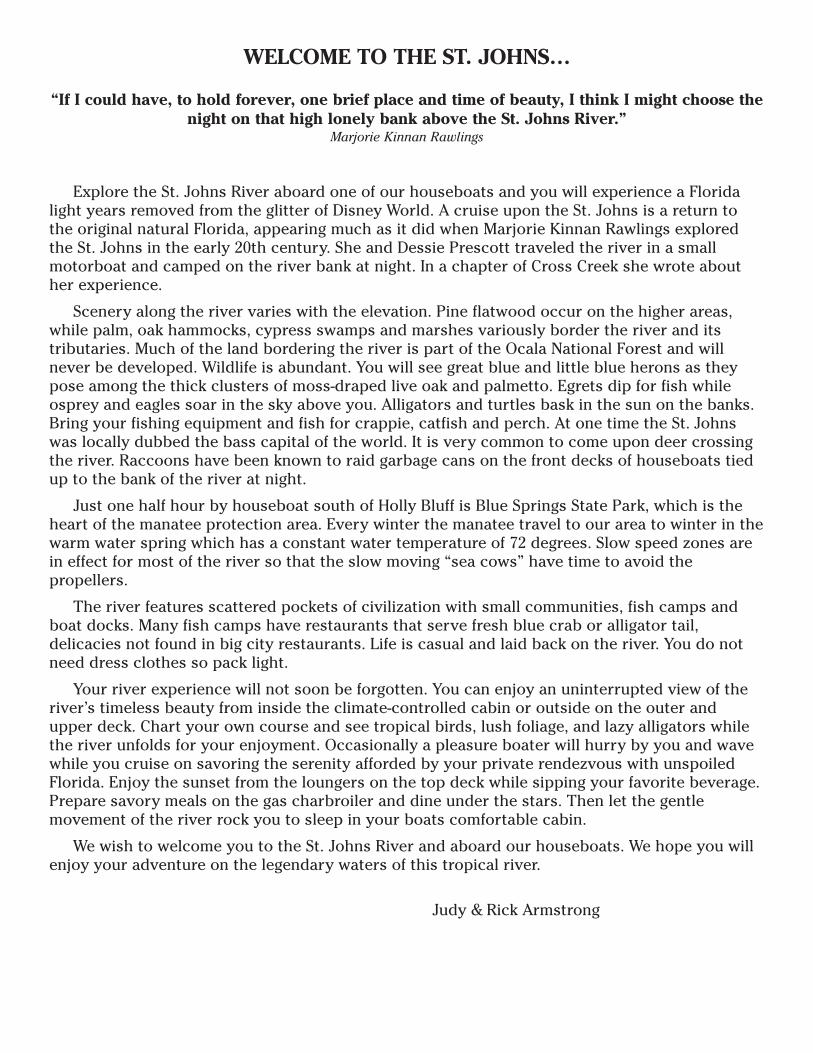
WELCOME TO THE ST. JOHNS…
“If I could have, to hold forever, one brief place and time of beauty, I think I might choose thenight on that high lonely bank above the St. Johns River.”
Marjorie Kinnan Rawlings
Explore the St. Johns River aboard one of our houseboats and you will experience a Floridalight years removed from the glitter of Disney World. A cruise upon the St. Johns is a return tothe original natural Florida, appearing much as it did when Marjorie Kinnan Rawlings exploredthe St. Johns in the early 20th century. She and Dessie Prescott traveled the river in a smallmotorboat and camped on the river bank at night. In a chapter of Cross Creek she wrote abouther experience.
Scenery along the river varies with the elevation. Pine flatwood occur on the higher areas,while palm, oak hammocks, cypress swamps and marshes variously border the river and itstributaries. Much of the land bordering the river is part of the Ocala National Forest and willnever be developed. Wildlife is abundant. You will see great blue and little blue herons as theypose among the thick clusters of moss-draped live oak and palmetto. Egrets dip for fish whileosprey and eagles soar in the sky above you. Alligators and turtles bask in the sun on the banks.Bring your fishing equipment and fish for crappie, catfish and perch. At one time the St. Johnswas locally dubbed the bass capital of the world. It is very common to come upon deer crossingthe river. Raccoons have been known to raid garbage cans on the front decks of houseboats tiedup to the bank of the river at night.
Just one half hour by houseboat south of Holly Bluff is Blue Springs State Park, which is theheart of the manatee protection area. Every winter the manatee travel to our area to winter in thewarm water spring which has a constant water temperature of 72 degrees. Slow speed zones arein effect for most of the river so that the slow moving “sea cows” have time to avoid thepropellers.
The river features scattered pockets of civilization with small communities, fish camps andboat docks. Many fish camps have restaurants that serve fresh blue crab or alligator tail,delicacies not found in big city restaurants. Life is casual and laid back on the river. You do notneed dress clothes so pack light.
Your river experience will not soon be forgotten. You can enjoy an uninterrupted view of theriver’s timeless beauty from inside the climate-controlled cabin or outside on the outer andupper deck. Chart your own course and see tropical birds, lush foliage, and lazy alligators whilethe river unfolds for your enjoyment. Occasionally a pleasure boater will hurry by you and wavewhile you cruise on savoring the serenity afforded by your private rendezvous with unspoiledFlorida. Enjoy the sunset from the loungers on the top deck while sipping your favorite beverage.Prepare savory meals on the gas charbroiler and dine under the stars. Then let the gentlemovement of the river rock you to sleep in your boats comfortable cabin.
We wish to welcome you to the St. Johns River and aboard our houseboats. We hope you willenjoy your adventure on the legendary waters of this tropical river.
Judy & Rick Armstrong
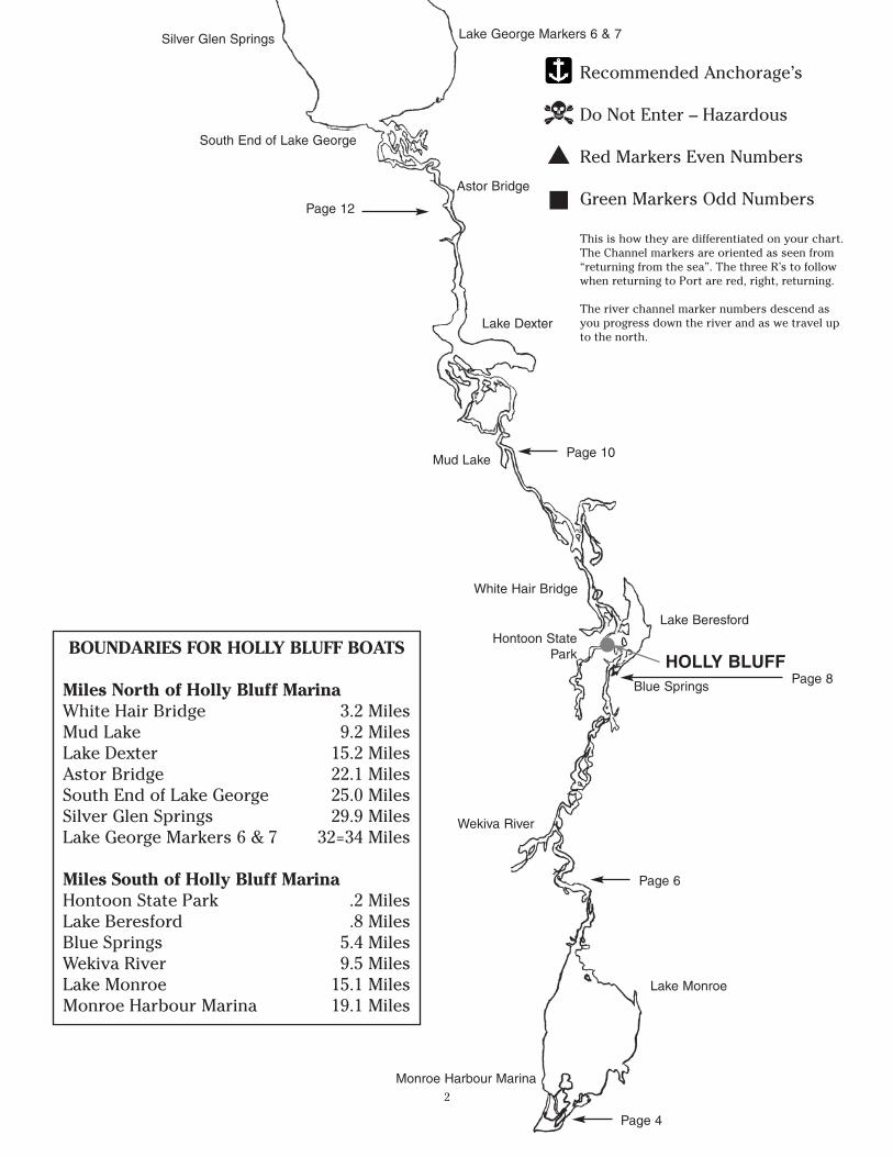
BOUNDARIES FOR HOLLY BLUFF BOATS
Miles North of Holly Bluff MarinaWhite Hair Bridge 3.2 MilesMud Lake 9.2 MilesLake Dexter 15.2 MilesAstor Bridge 22.1 MilesSouth End of Lake George 25.0 MilesSilver Glen Springs 29.9 MilesLake George Markers 6 & 7 32=34 Miles
Miles South of Holly Bluff MarinaHontoon State Park .2 MilesLake Beresford .8 MilesBlue Springs 5.4 MilesWekiva River 9.5 MilesLake Monroe 15.1 MilesMonroe Harbour Marina 19.1 Miles
Recommended Anchorage’s
Do Not Enter – Hazardous
Red Markers Even Numbers
Green Markers Odd Numbers
This is how they are differentiated on your chart.The Channel markers are oriented as seen from“returning from the sea”. The three R’s to followwhen returning to Port are red, right, returning.
The river channel marker numbers descend asyou progress down the river and as we travel upto the north.
2
▲
■
Lake George Markers 6 & 7Silver Glen Springs
South End of Lake George
Astor Bridge
Lake Dexter
Mud Lake
White Hair Bridge
Hontoon StatePark
Lake Beresford
Blue Springs
Wekiva River
Lake Monroe
Page 4
HOLLY BLUFF
Monroe Harbour Marina
Page 6
Page 10
Page 12
Page 8
3
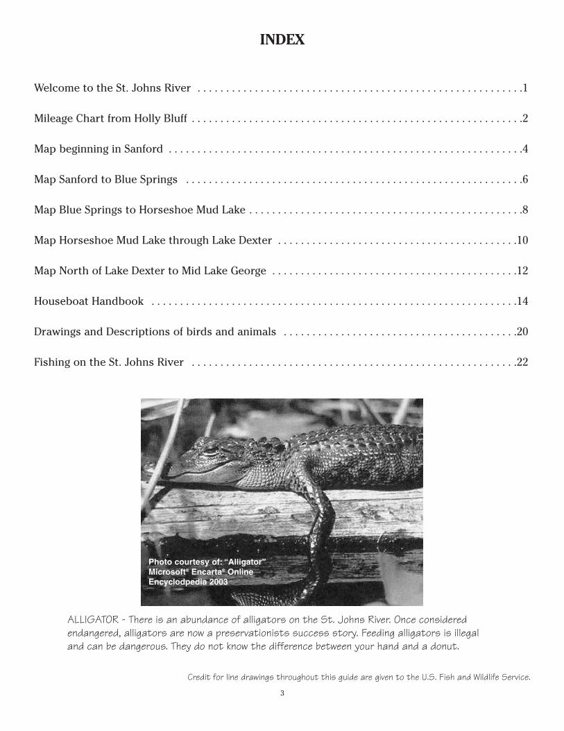
INDEX
Welcome to the St. Johns River . . . . . . . . . . . . . . . . . . . . . . . . . . . . . . . . . . . . . . . . . . . . . . . . . . . . . . . . .1
Mileage Chart from Holly Bluff . . . . . . . . . . . . . . . . . . . . . . . . . . . . . . . . . . . . . . . . . . . . . . . . . . . . . . . . . .2
Map beginning in Sanford . . . . . . . . . . . . . . . . . . . . . . . . . . . . . . . . . . . . . . . . . . . . . . . . . . . . . . . . . . . . . .4
Map Sanford to Blue Springs . . . . . . . . . . . . . . . . . . . . . . . . . . . . . . . . . . . . . . . . . . . . . . . . . . . . . . . . . . .6
Map Blue Springs to Horseshoe Mud Lake . . . . . . . . . . . . . . . . . . . . . . . . . . . . . . . . . . . . . . . . . . . . . . . .8
Map Horseshoe Mud Lake through Lake Dexter . . . . . . . . . . . . . . . . . . . . . . . . . . . . . . . . . . . . . . . . . .10
Map North of Lake Dexter to Mid Lake George . . . . . . . . . . . . . . . . . . . . . . . . . . . . . . . . . . . . . . . . . . .12
Houseboat Handbook . . . . . . . . . . . . . . . . . . . . . . . . . . . . . . . . . . . . . . . . . . . . . . . . . . . . . . . . . . . . . . . .14
Drawings and Descriptions of birds and animals . . . . . . . . . . . . . . . . . . . . . . . . . . . . . . . . . . . . . . . . .20
Fishing on the St. Johns River . . . . . . . . . . . . . . . . . . . . . . . . . . . . . . . . . . . . . . . . . . . . . . . . . . . . . . . . .22
ALLIGATOR - There is an abundance of alligators on the St. Johns River. Once consideredendangered, alligators are now a preservationists success story. Feeding alligators is illegaland can be dangerous. They do not know the difference between your hand and a donut.
Credit for line drawings throughout this guide are given to the U.S. Fish and Wildlife Service.
Photo courtesy of: “Alligator”Microsoft® Encarta® OnlineEncyclodpedia 2003
4
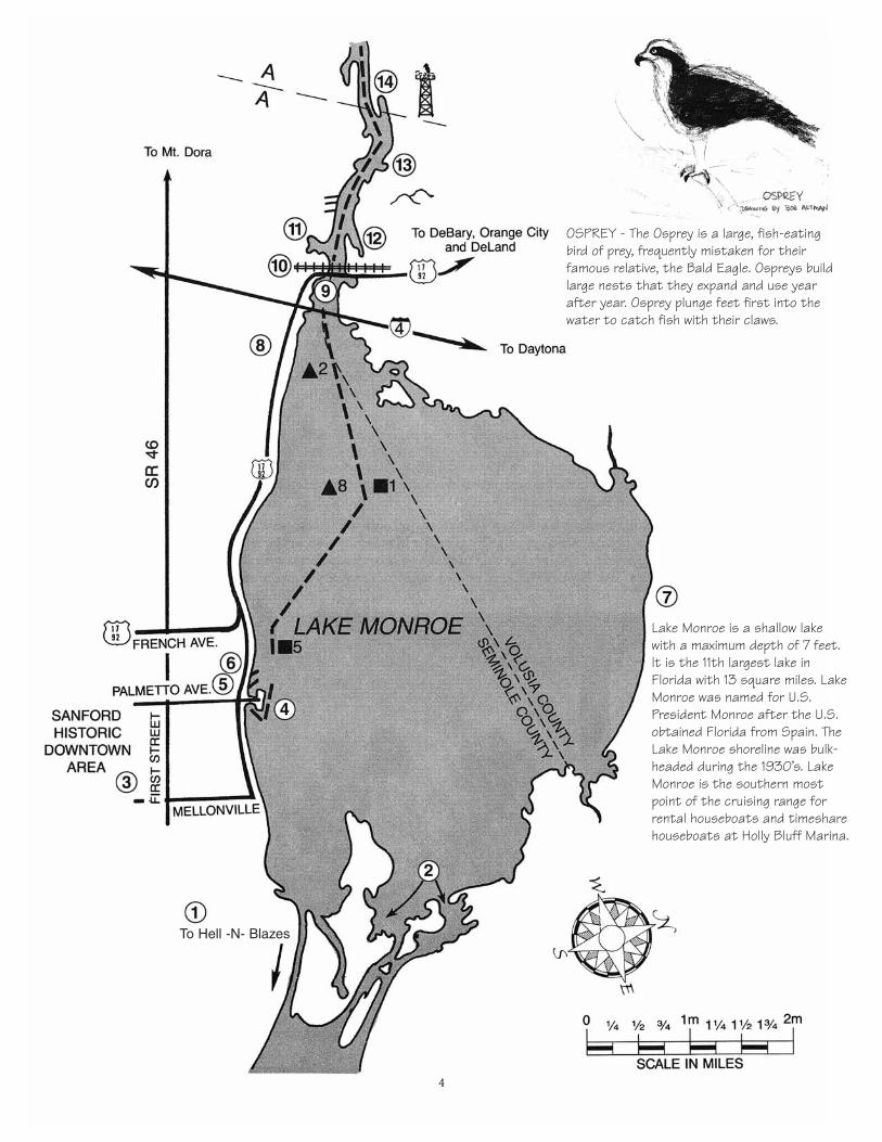
OSPREY - The Osprey is a large, fish-eatingbird of prey, frequently mistaken for theirfamous relative, the Bald Eagle. Ospreys buildlarge nests that they expand and use yearafter year. Osprey plunge feet first into thewater to catch fish with their claws.
Lake Monroe is a shallow lakewith a maximum depth of 7 feet.It is the 11th largest lake inFlorida with 13 square miles. LakeMonroe was named for U.S.President Monroe after the U.S.obtained Florida from Spain. TheLake Monroe shoreline was bulk-headed during the 1930’s. LakeMonroe is the southern mostpoint of the cruising range forrental houseboats and timesharehouseboats at Holly Bluff Marina.
To Hell -N- Blazes
5
(1) To Hell -N- Blazes - The channel is not marked for navigation past this point. The riverbecomes very shallow and is mostly used by airboats. From this point the river stretchesanother 100 miles south and slightly east to one of the southernmost lakes on the St. Johnscalled Lake Helen Blazes where the St. Johns is thought to originate.
(2) Natural Flow of the River
(3) Sanford Historic District - Sanford’s first permanent settlement was established in 1836,when troops were stationed on the south bank of Lake Monroe to protect settlers fromindian attacks. In 1870 General Henry S. Sanford, former minister to Belgium, purchased12,535 acres of land and laid out the town which was eventually named in his honor. Todayantique shops and restaurants line First Street, which is an easy walk from Monroe HarbourMarina.
(4) Monroe Harbour - This is the home port of the Rivership Romance, a ship that offers dailytours of the St. Johns. Monroe Harbour is a full service marina which also includes a hoteland separate cocktail lounge. Small boats can dock here if a slip is available. Call (407) 322-2910 for docking instructions, or call them on channel 16 on the VHF marine radio.Navigation is very tight in this marina. Be careful.
(5) Seminole County Court House
(6) City Hall
(7) Florida Power & Light - The plant was built in 1926.
(8) Central Florida Zoo - To visit the zoo you would have to dock at Monroe Harbour Marina orHidden Harbour Marina and hire a taxi to travel to the zoo.
(9) Highway US 17-92 bridge. This is a stationary bridge with plenty of overhead clearance.
(10) CSX Railroad Bridge - Amtrak, Autotrain and freight traffic all cross the river on this bridge.This bridge will have to be opened before you enter Lake Monroe. Call the bridge tender onchannel 16 of your marine radio and transfer to channel 9 or channel 13 to ask for the bridgeto be raised.
(11) Boat Tree Marina and Captains Cove Restaurant - This marina welcomes our boats withexcellent docking and fuel. Captains Cove Restaurant on the marina property has good foodand a full bar. They also have a deli for take-out food. Frequently they have liveentertainment around the pool area. No overnight docking. Call (407) 322-1610 for dockinginstructions or call them on channel 16 on the VHF marine radio.
(12) Manatee Refuge & another Florida Power & Light Plant - During the winter months manateecongregate near this plant where the warm water is discharged into the St. Johns.
(13) Meadow Lea on the River Mobile Home Park
(14) Osprey nests on Florida Power & Light Towers
6
7
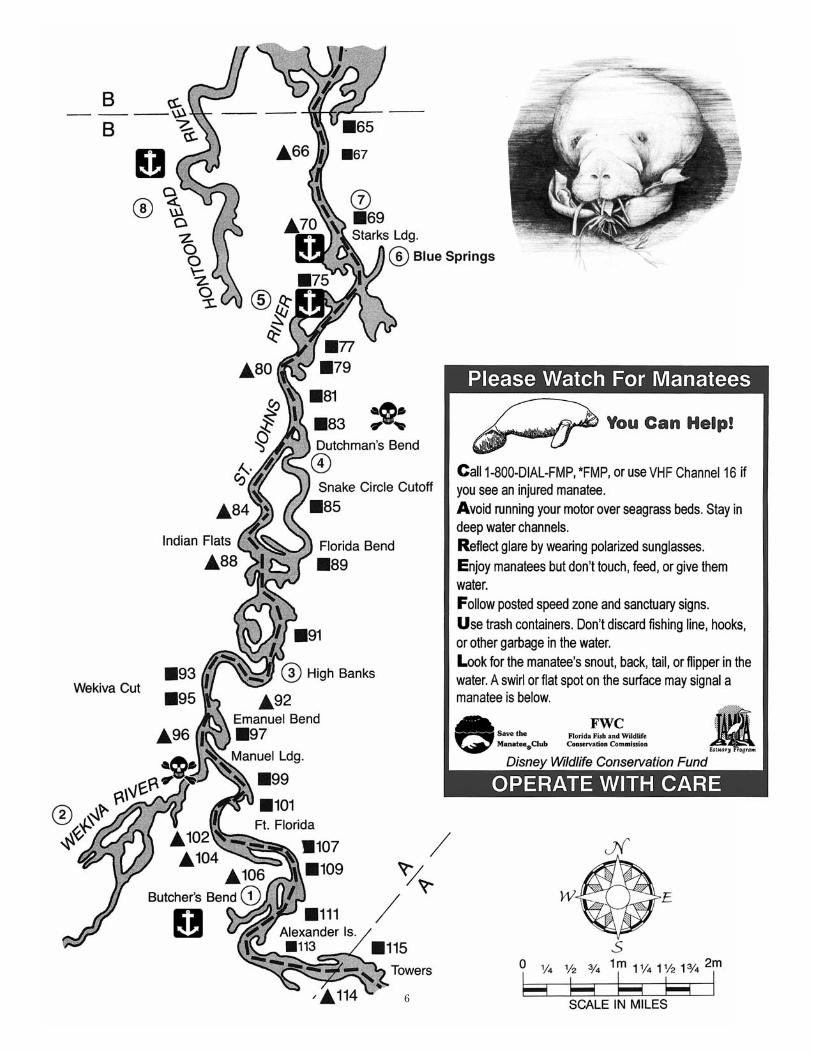
(1) Butcher’s Bend - There is good anchorage behind this island located between markers 109and 111.
(2) The Wekiva River leads back to Rock Springs and Wekiva Springs which combinedcontribute daily to the river over 140 million gallons of spring water. Wekiva is an indianword meaning springs. This river is very scenic but is too narrow for our houseboats. If youhave a small boat this is a great area to explore.
(3) Highbanks Marina is now a campground and RV resort of the same name. In 1766 naturalistJohn Bartram called this area the river’s “sweetest shores”. They have a store and snack barbut are only accessible by small boat.
(4) Dutchman’s Bend is deep at the mouth, but anything past the island is very shallow. SnakeCircle Cutoff is absolutely too shallow for a houseboat.
(5) Between Markers 75 and 77 go behind the island for good anchorage.
(6) Blue Springs State Park, Marker 71, is a winter refuge for manatee. The spring watertemperature year-round is 72 degrees. Do not attempt to moor the boat at the dock. Boatsmust be beached just south of the dock on the sandy area. The park closes at dusk. Noovernight docking is allowed. No alcoholic beverages are allowed in any state park inFlorida.
(7) Near Blue Springs is marker 69. Go behind the island on the west side of the river forexcellent anchorage.
(8) Hontoon Dead River has deep water and many good places to anchor or tie up to a tree. Ifyou arrive late and want to spend the night close by the marina this is a great area. Downthe Hontoon Dead River you will see Snake Creek on the left. Snake Creek is very shallow.DO NOT ENTER. Please note you cannot get back to the St. Johns going south on theHontoon Dead River by houseboat. We suggest you do not go farther than Snake Creek.
MANATEE - West Indian Manatee, sometimes called theFlorida Manatee, is a large, gentle animal that winters inour area. Between the months of October and April,when the weather is cool, manatee are commonly seen inthe warm 72º water of Blue Springs. During warmweather you may see manatee munching on grass alongthe shores of the St. Johns.
8
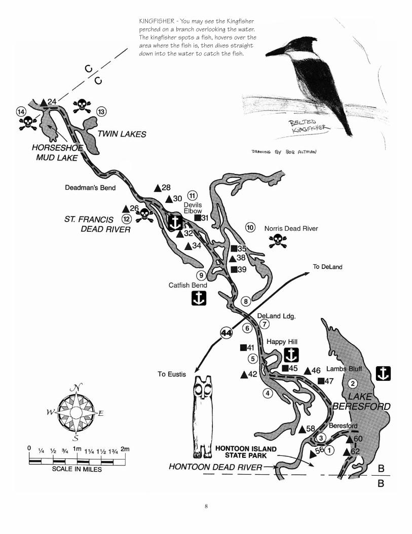
KINGFISHER - You may see the Kingfisherperched on a branch overlooking the water.The kingfisher spots a fish, hovers over thearea where the fish is, then dives straightdown into the water to catch the fish.
9
(1) Hontoon Island State Park consists of 1650 acres, nature trails, indian mounds and picnicarea. The island was home to the Timucuan Indian tribes. These people thrived on snailsand other shellfish gathered from the river. Through the years discarded shells accumulatedto form two 15 foot high mounds. Overnight dockage is available at this state park. There isa fee to dock overnight. Call on channel 16 to make arrangements.
(2) Lake Beresford is located just South of Holly Bluff and has excellent fishing and mooring. Bevery careful entering this lake from the river as there are many submerged pilings near theshoreline, which may not be visible. Stay near the markers. During warm summer months itis not a good idea to overnight in this lake due to hatching blind mosquitos which do notbite but are quite a mess to clean up. If you have a small boat you can go to Sunrise FishCamp and it is located about mid way down Lake Beresford and on the left side. LakeBeresford Yacht Club is a private club and is located next to Sunrise Fish Camp. If you are amember of the Florida Council of Yacht Clubs you would be welcomed at this club.
(3) HOLLY BLUFF MARINA has been owned and operated by Judy and Rick Armstrong since1992. We are a full service marina with boat sales, boat repair, houseboat rental, pontoonrental, fuel and boat storage. Holly Bluff has managed timeshare houseboats for Royal HostResort and Vacation Club of Canada since 1997. We monitor channel 12 or can be reached byphone at 386-822-9992 from 8:30 a.m. - 5 p.m. EST.
(4) Mud Lake is too shallow for our houseboats. DO NOT ENTER.
(5) Between channel marker 41 and 42 anchor behind the island on the river’s east side.
(6) Pier 44 Marina has fuel and service.
(7) Shady Oaks Restaurant and Bait Shop does not allow our houseboats but is a good place togo if you have a smaller boat, or you many want to go by car.
(8) Boat Show Marina has a restaurant but no fuel. You can dock at The Wharf WaterfrontRestaurant if space is available. It has good food and casual atmosphere. (386) 734-6100
(9) Catfish Bend between marker 36 and 38 is an excellent place to moor the boat. There aresome homes in this area so you feel like you are near civilization. On the north side ofCatfish Bend you will notice an area where people dock and have camp fires. You can tie thehouseboat between two palm trees and not worry about the anchor slipping during thenight. Pets can go ashore on a leash.
(10) Norris Dead River - DO NOT ENTER - Too narrow for houseboats. If you have a small boat,this is a beautiful area to explore. Fishing is good in this area.
(11) Devils Elbow between marker 30 and 32 has good dockage behind the island on the Westside of the river.
(12) St. Francis Dead River - DO NOT ENTER - Too Shallow
(13) Twin Lakes - DO NOT ENTER - Too Shallow
(14) Horseshoe Mud Lake - DO NOT ENTER - Too Shallow
10
– DANGER –Stay in channel. Many pilings.
Pass outside of signs indicating pilings.
– DANGER –STAY IN CHANNEL
(Channel is a straight linebetween markers “8” and “10”)
HERON - Called “Lady of the Waters” by Audubonbecause of its grace and beauty, the Great BlueHeron is common to see on the St. Johns River.Great White Herons have light colored legs whichdistinguish them from the Great Egret which hasblack legs. Great White’s are less common on theSt. Johns.
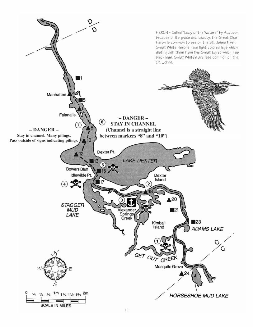
(1) Get Out Creek is too shallow - DO NOT ENTER - You Might Not Get Out!
(2) Marker 18 entrance to Alexander Spring Creek is too shallow for our boats.
(3) Past Marker 18 is another entrance to Alexander Spring Creek. The water is deep here at theentrance but do not go too far back as it is very narrow and hard to maneuver.
(4) Stagger Mud Lake - No Anchorage - Too Shallow
(5) Lake Dexter is a big shallow lake. Several of our customers have attempted to go into thislake and ran aground. This lake is off limits to our boats.
(6) DANGER - Submerged pilings. Between Markers 12 and 5 you must stay in the channelwhich veers to the left of Lake Dexter. The channel is a straight line between Markers 8and 10. Do not mistake Marker 10 in Lake Dexter for Marker 10 in Lake George.
(7) Astor Landing Campground and Marina - Located at Channel Marker 8, approximately 3miles south of the Astor Bridge and across from Lake Dexter. Overnight docking is available.Power is available (30 amp) only. Water and pump-out also available but no fuel. Small Ship’sStore. Call for docking instructions as this area is very shallow. (352) 759-2121.
11
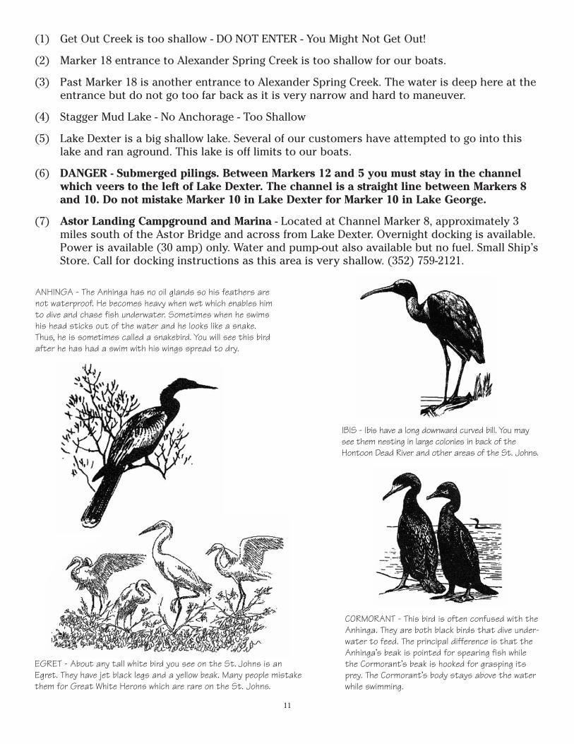
ANHINGA - The Anhinga has no oil glands so his feathers arenot waterproof. He becomes heavy when wet which enables himto dive and chase fish underwater. Sometimes when he swimshis head sticks out of the water and he looks like a snake.Thus, he is sometimes called a snakebird. You will see this birdafter he has had a swim with his wings spread to dry.
IBIS - Ibis have a long downward curved bill. You maysee them nesting in large colonies in back of theHontoon Dead River and other areas of the St. Johns.
EGRET - About any tall white bird you see on the St. Johns is anEgret. They have jet black legs and a yellow beak. Many people mistakethem for Great White Herons which are rare on the St. Johns.
CORMORANT - This bird is often confused with theAnhinga. They are both black birds that dive under-water to feed. The principal difference is that theAnhinga’s beak is pointed for spearing fish whilethe Cormorant’s beak is hooked for grasping itsprey. The Cormorant’s body stays above the waterwhile swimming.
12
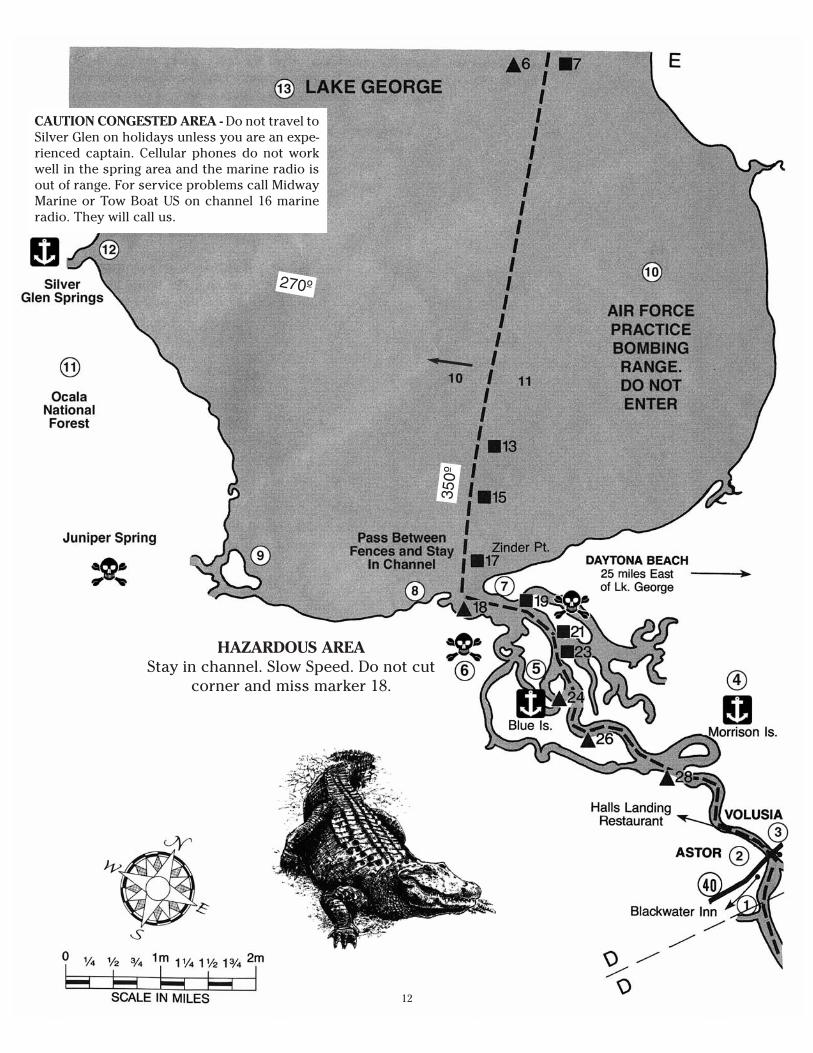
CAUTION CONGESTED AREA - Do not travel toSilver Glen on holidays unless you are an expe-rienced captain. Cellular phones do not workwell in the spring area and the marine radio isout of range. For service problems call MidwayMarine or Tow Boat US on channel 16 marineradio. They will call us.
HAZARDOUS AREAStay in channel. Slow Speed. Do not cut
corner and miss marker 18.
270º
350º

(1) Midway Marine is closed at the present time. Blackwater Inn Restaurant and WilliamsLanding are located just north of Midway Marina. They both offer good food and overnightdocking is available.
Astor Bridge Restaurant and Marina - Directly across the river from Blackwater Inn and justsouth of the S.R. 40 Astor Bridge. Fuel and pumpout are available. Overnight docking with(30 amp only) power is also available. Limited Ship’s Store and motel rooms. Dockside Barand Grill has a full bar.
(2) Astor is a riverside community. State Road 40 runs through Astor east to Ormond Beach andwest to Silver Springs and Ocala. You will go under the SR 40 bridge.
(3) Blair’s Jungle Den (386) 749-2264. Very hazardous docking for houseboats. Small boats arefine. Fuel, ice, and snacks. Bait and tackle. Motel rooms. Ship’s store. Boat batteries. Open 7 AM to 5 PM.
(4) Morrison Island between markers 26 and 28 offers good moorage.
(5) Marker 24 go behind the island for good moorage.
(6) Blue Island Creek is too shallow for our boats. Best not to enter.
(7) Volusia Bar is the most hazardous area of your cruising range. Slow speed in this area. It isvery shallow. Stay in channel. When heading north at marker 19 do not cut the corner, lookto the west side of the river and go to marker 18 then head north to marker 17. If you shouldrun aground call Tow Boat US on channel 16. Nathan Bush makes a good living pullingpeople out of this area.
(8) Entering Lake George pass between the fences and stay in channel. There are rocks on eachside of the jetties.
(9) Juniper Spring is too shallow. DO NOT ENTER.
(10) On the east side of Lake George the Jacksonville Naval Air Station has set up practice areas fortarget bombing. They have 3 targets with a shoreside statistics finding tower. Sometimes youcan see them practicing. DO NOT ENTER THIS AREA. They have been known to buzz boats.
(11) The Ocala National Forest borders the west side of the lake.
(12) Silver Glen Springs is the most popular destination point for boaters on the river. From thesouth travel to marker 10, turn northwest compass heading 270 or 11 o’clock if you have nocompass. When you get close to shore you will see the water beginning to clear up. Passbetween the red and orange buoys and go right of the island. There are no signs that saySilver Glen Springs. If you can’t find the spring watch forboats entering or leaving.
(13) Lake George is the second largest lake in Florida secondonly to Lake Okeechobee in size. It is 11 miles in lengthand 5 miles in width. It is a shallow lake and can getrough very fast. Do not enter unless the weather is good.
13
SANDHILL CRANES - Every winter we see Sandhill Cranes in our area of the St.Johns. The Sandhill Crane is a large, long-necked marsh bird with a bald red crown,and a gray and rust body. You may see them wading through marshes eating youngshoot but are more likely to see them in fields hunting for insects. They mate forlife and travel in pairs.
14
HOUSEBOAT HANDBOOK
The following is a handbook for the operation of Holly Bluff Marina rental houseboats andtimeshare houseboats. We suggest you read this before you take the boat out tofamiliarize yourself with the boat operation prior to your orientation. During theorientation your instructor will briefly go through this handbook to familiarize you withthe information located herein. We suggest you use this as a guide and if you have anyquestions, please ask your instructor during the orientation. We have tried to cover mostsituations you might encounter while underway to make your stay more enjoyable.
II. Gauges & Meters & Misc. on Boat ConsoleA. Volt Gauge - This gauge should register above 12 volts after the engine warms up.
If it stays below 12 volts the possibility of a bad battery exists. Please report thisto the marina.
B. Temperature Gauge - This gauge should register between the second and thirdmark. If it exceeds this the overheat alarm will sound. If this happens shut downthe engine and call the marina.
C. Oil Pressure Gauge - The Oil Pressure should be greater than 20. Shut down theengine and call the marina if oil pressure is lost.
D. Tachometer - Idle speed is between 700 and 900 rpm’s, cruising speed is 2000 to2400 rpm’s. Do not exceed 3000 rpm’s except in emergency situations. Yourboat will use 2 1/2 to 3 gallons of fuel per hour at cruising speed, and 8 to 10gallons per hour at full speed.
E. Fuel Gauge - Both tanks will be filled before you depart on your cruise at nocharge to you. When you return the tanks will be filled again and you will payonly for the fuel you use.
F. Hour Meter - The hour meter tells the amount of hours the engine has been inoperation.
G. Tilt & Trim Buttons - The tilt & trim buttons control the position of the lower unit.Under normal conditions leave these alone. If you should run aground in shallowwater or if you want to check the condition of the prop, trim the unit up bypushing the top button only. Do not run boat in “up out” position for longperiods of time or at greater than 2000 rpm’s. Damage to the engine or drivecould result if you run engine with unit out of water.
H. Fresh Water Button - This button activates the fresh water pump. Leave thisbutton on when using water system such as showering or washing dishes. Turnthis off at night before retiring. This boat holds at least 140 gallons of fresh waterand the pump pumps water at 3 gallons per minute. Conserve water - if youshould run out, water is easily accessible at all large marinas. The water fillconnection will be shown at orientation. The pump has an automatic pressure
15
switch, which shuts off at 30 lbs. pressure. IMPORTANT: If you run out of waterbe sure to shut the pump off.
I. Horn - This button is on the console. One short blast means boat is turning tostarboard (right) side. Two short blasts means boat is turning to port (left side).Three short blasts means boat is in reverse. Four or more short blasts meansDanger. One long blast should be sounded when boat is leaving slip, pier orwharf. To open bridges sound one long and one short blast.
J. Blower - The blower should be turned on for a few minutes before starting theengine to remove any gasoline fumes that might be built up in the engine room.For safety’s sake always open the hatch for a few minutes before starting theengine. Remember to close the hatch and turn off the blower after the enginestarts.
K. Running Lights - Use lights only at night. Night running is not recommendedexcept in an emergency situation. Leave anchor light on while moored betweendusk and dawn.
L. Vertical Light Switches on Side of Console - Turns on porch lights and interiorlights. Burn 12 volt lights only when you are not connected to shore power - 110volt lights are to be used dockside or with powerplant operation.
III. Throttle and Gear ShiftLeave the throttle in the straight up and down position to start the engine. Thisis neutral. If the engine is cold disengage throttle and pump throttle one or twotimes then hold about one-third throttle. The engine is now ready to start. Whenthe engine is cold maintain 1500 rpm’s until the engine warms up to the firstmark on the temperature gauge. After the engine warms up pull the throttle backto neutral. Engage the shift mechanism. Push the shift handle forward to shiftthe boat into forward gear, push if further forward to accelerate the boat.Reverse is obtained by pulling the shift handle toward the rear of the boat.Caution: Shifting from reverse to forward or forward to reverse withoutletting the engine slow down will possibly damage the lower unit. Be suredrive unit is down before starting engine.
IV. SteeringBoats steer from the back not from the front like a car. Steering the boat rightturns the front of the boat right and brings the rear of the boat left. Steering theboat left turns the front of the boat left and brings the rear of the boat right. Theboat is stopped by putting the boat in reverse. Over throttling in reverse willcause less breaking. Stop the boat gently at about 1500 rpm’s, anything over1500 will not efficiently and effectively slow down the boat.Operate the boat at slowest speed possible inside harbors and idle zones.Do not cause a wake-Idle when possible.
16
V. Depth FinderThe depth finder indicates the depth of the water in feet. Your boat drafts aboutthree feet so try to stay in water four feet and deeper.
VI. Generator (Power Plant)The Generator “Stop” and “Start” buttons are located on the console. Beforestarting the generator the blower should be turned on for a few minutes (sameas starting engine). Set the dial on the “OFF” position, be sure air conditioner isturned off. Push the “Start” button until generator starts. Allow generator about5 minutes to warm up before turning dial to generator or onan position, anythingon boat may be turned on now. Push “Stop” button to stop generator and returndial to “Off” position when generator is not in use. However, if shore power isdesired, plug boat into dock receptacle before turning dial to “shore power”position.
VII. Marine RadioA. Marine Radio Controls
(1) OFF/VOL KNOB - The off/vol knob is used to apply power to the unit aswell as controlling the volume level. Turning the knob clockwise turns theunit on. A click indicates the unit is on. When initially turning the radio on,Channel 16 will appear on the display. Be sure volume is adjusted so youcan hear transmission.
(2)SQ KNOB - Set the squelch by turning the knob clockwise until the noise isheard. The knob should be turned counter-clockwise until the noise justdisappears. Your unit should now be free of noise between transmissions.
(3)Most areas are served by a National Weather Service Transmitter. Thechannel for our area is 3. Press the down button until you reach theweather channel. Weather Stations transmit continuously so you shouldfind activity right away.Note: The transmitter is disabled when receiving a weather station.
B. Making the Call(1)Apply power to the unit by turning the OFF/VOL knob clockwise until it
clicks. Adjust the volume. Channel 16 will appear in the display. Ifnecessary adjust the squelch by turning the knob counter-clockwise untilthe noise just disappears. You should not have to adjust the squelch again.Our marina monitors channel 12 from 8:30 a.m. to 5:00 p.m. To changefrom Channel 16 to Channel 12 simply press the up or down button untilthe unit displays the desired channel, then release the button. Be sure themarine radio is set to 25 watts for better transmission if you are not withinsight of marina.
(2)You are now ready to transmit by pressing and holding the push to talkswitch on the hand microphone. To make the call speak clearly, distinctlyand directly into the microphone. Call the marina using its name followed
17
by the name of your vessel, for example: Holly Bluff Marina Boat ____calling Holly Bluff Marina. Release the push to talk switch and wait forreply.Limit the first transmission to 30 seconds or less then wait at least 2minutes before repeating the call if contact is not made. Keep allcommunications as brief as possible and give the call name of the ship atthe end of the communications. Remember when calling other marinas orprivately owned boats to call on Channel 16 then switch to anotherchannel such as 68 before transmitting your message. Channel 16 is usedonly for calling. Do not use for casual conversation, this is not a CB. Do notuse Channel 17, 21 or 22. These are for law enforcement and Coast Guardonly.
C. Calling for AssistanceYou will be within radio contact with our Marina if you stay no more than 20miles from us.
If you are having problems with your boat go to the nearest bay or safetyharbor and anchor, stay out of the main river channel. Before calling forassistance please determine your location. Give us the name of the bay orpreferably marker number. Look for landmarks such as a home or resort youare nearby. Be able to describe the mechanical difficulty you are having soour mechanics can bring necessary parts and tools to make repairs. Ourmarina closes at 5 p.m. If you are experiencing a problem please call us priorto 5 p.m., otherwise we will be unable to assist you until the next morning.For safety reasons we do not perform service calls after dark. If you areunable to call our marina call the marina nearest you. If all marina calls fail,call the U.S. Coast Guard on Channel 16. When calling for assistance be sureto give marina or Coast Guard your exact location and nature of problem. Besure to leave your radio on Channel 12 so we can contact you.
D. What to do in Case of Serious Accident or CollisionIn case of serious accident or collision everyone should put on a life jacketwhen the boat is in operation. If an accident occurs move out onto the decks.Do not abandon the boat unless it is sinking or on fire. One person should bein charge of turning off the engine and making radio distress signals. Followthe same procedure for operating the radio as calmly as possible.
Begin The Transmission With:(1)Mayday, Mayday, Mayday(2)Identify yourself and call any vessel that can respond.(3)Give the location of the boat and nature of difficulty.(4)Release the button to listen for response.(5)If no response is made repeat call in one minute.
Warning: The Mayday call should be used only in extreme emergencies where livesare in danger. Do not use for running aground or minor maintenance problems.
18
VIII. RefrigeratorWe set the unit before your departure for the entire trip. Please do not changerefrigerator from this setting unless a problem occurs with the operation.Instructions are printed inside refrigerator.
IX. StoveIf your boat has a stove, or stove/oven combination, with a stove top that acts asa cover, stove top must be up and locked in place for elements to heat.
X. Marine HeadDo not put anything in the head that has not been eaten first. Do not under anycircumstances put sanitary napkins in marine head. When flushing hold inbutton for a minimum of 10 seconds (count 10) to clear line and prevent odor.Waste is discharged into a holding tank and must be pumped out periodically.Holding tanks are pumped out prior to departure. Pump out facilities areavailable at various major marinas along the river. Charges vary according to themarina.Caution: Cigarette butts will stop up marine head.
XI. ShowerConserve water - shower with a friend.
XII. Air-Conditioning and HeatA. Roof mounted air and heat.
1. For Cooling - Turn the selector switch to the “cooling” position. Rotate thethermostat (temperature controls) switch to the position that is mostcomfortable for you. When the temperature of the air entering the airconditioner drops below the selected setting the compressor willautomatically turn itself off. The air conditioner, while in the cooling mode,will continue to cycle the compressor on and off in the above mentionedfashion until the selector switch is turned to another mode of operation.
2. Heat - The heater is intended to take the chill out of the indoor air whenthe air is a few degrees too cool for comfort. It is not a substitute for afurnace. Turn the selector switch to the “Heat” position. Rotate thethermostat (temperature control) switch to the position that is mostcomfortable for you. The heater will automatically turn on.
B. Central heat and air - position thermostat according to your needs.
XIII. BatteriesThe big battery is for main engine, lights, toilet, fresh water pump and other 12volt accessories. The small battery is for generator and its accessories only.Both batteries are connected at all times. Should the big battery run down,
please don’t panic, the generator should start. Both batteries are charged whilethe generator is running. While anchored, run generator at least one hour every24 hours to recharge batteries. Batteries may be recharged at any marina.
XIV. Fuel TanksThere are two fuel tanks. When the tank is on the valve is in line with the fuelline. When the tank is off the valve is across the fuel line. Both tanks should beon, therefore, when refueling be sure to fill both tanks.
XV. Anchoring the BoatIn anchoring your boat use all the anchor line before setting the anchor. This willprovide proper scope and increase your security. Always anchor off the bow ofthe boat into the wind. Do not beach your boat. Always check anchor beforeturning in for the evening. Leave anchor light on when mooring at night. Theanchor light is the white light over the porch of the boat. To pull up the anchor,position one person on the front of the boat to pull in the line. The pilot shouldgently ease boat in direction of the anchor. When the line is straight up anddown pull up anchor.
XVI. NavigationIn navigation of the main lakes or entering marked bays, remember that in goingupstream or against the current the red buoys, which are pointed, should be onyour starboard or right and the black or green buoys, which have a flat top,should be on your left or port. Going downstream or with the current, this isreversed, with the red on the left and the black or green on the right.Crossovers and channels are marked on the map which we have furnished andshould be followed.Do not travel at night except in extreme emergency!
XVII. Gas CharbroilerA. Lighting Precautions
1. Open hood before lighting match.2. Turn on gas at tank valve.3. Strike match, insert in hole.4. Push in control knob, on post - turn to Hi to pre-heat, cover for 5 minutes.
Turn on Lo - start cooking.5. Be sure to turn grill off when cooking is finished.
NOTE: While cooking, excess fats and greases drip to the bottom of the grill anddrain into the easily removed grease cup located on the post at the back of thegrill. Please check this and empty grease when cup is full.
19
XVIII. Rules of the Road(1) In crossing situations the boat to the starboard (on right) has the right of
way. Slow down and permit him to pass.(2) In passing situations the boat being overtaken has the right of way.(3) In meeting situations (head on) both vessels turn to starboard (right) and
pass port to port.(4) International rules prohibit sailboats and other small craft from hindering
the passage of large boats that cannot move out of a channel.(5) Sailboats under sails always have the right of way over power boats except
in item 4. Sailboats under power are considered motor boats.(6 ) No wake speed inside marina harbors. Remember you are responsible for
any damage your boat causes.(7) Stay clear of barges. Do not cross in front of barges, they have no
brakes.(8) Do not dive off top deck of boat.(9) Life jackets on boat are for emergency use only. Do not use for swimming.(10) When going into a marina please be courteous, wait for your turn to dock
if there are several boats in the harbor.(11) Do not swim around boat when engine is running.
XIX. Overnight Docking FacilitiesYou can dock your boat overnight at most large marinas. In most cases there is afee which should range from $10 to $20 per night. Electricity and water isavailable at most marinas.
XX. For Your Safety1. Always open the hatch for a few minutes before starting the engine. There is a
bilge blower, operated by a switch on the console. This should be used for afew minutes before starting. Remember, close the hatch and turn off theblower after the engine starts.
2. Life jackets are stored in the closet of your boat. It is recommended that youplace one jacket per person in easy reach while the boat is in use. Butremember, they are not for swimming. Use your own jackets or rafts forswimming.
3. To avoid personal injury, stay inside rails while boat is in operation,especially dangerous is dangling feet and legs past any of the hand rails.
4. Check out drive area to be clear of persons before starting engine.5. Do not swim or try to use boarding ladder while the engine is running.6. Do not travel at night.7. Dock the boat before dusk in a secure area out of the main river channel.
20
XXI. Miscellaneous Tips1. Be sure to check prop with instructor before departure. You are responsible
for damaged or destroyed props.2. Check to be sure anchor is securely tied to boat before throwing overboard.
They are extremely hard to retrieve, anchor line does not float. You must payfor a lost anchor.
3. Before going under a bridge check to be sure roof rails will clear.4. Life jackets are for emergency purposes only. You must pay for them if they
are damaged.5. Deck chairs taken to the top deck should be taken down when not in use.
They will blow off top deck if not in use. Bring down when returning boat toease check-in.
6. Do not swim around boat while engine is running. This is extremelydangerous and can cause death or dismemberment.
7. Alcohol and boat operation do not mix. Be sure driver does not use drugs oralcohol while responsible for boat operation. Alcohol or drugs are involved inalmost 100% of boating accidents.
XXII. WeatherWhen potentially dangerous wind or water conditions exist do not leave thedock.When afloat, watch for these signs of dangerous weather ahead:1. Dark, threatening clouds may indicate a squall or thunderstorm.2. Watch for a steady increase in wind.3. Heavy static on the radio may indicate thunderstorms nearby.4. Always check radio weather broadcasts and warnings. Channel 2 and 3 on the
marine radio broadcast weather.Lightening storms occur frequently in Central Florida. At the first sign proceedtoward river bank with low tree line and anchor until storm has passed.Fog can be a serious threat to the boater. It forms frequently in coastal waters,especially during summer. Fog may reduce visibility to only a few feet.Landmarks and navigational aids disappear. At first sign of fog, the boater shouldproceed to lighted buoy. If practical, he should return to harbor.Caught in Foul Weather1. Reduce speed. Proceed with caution.2. Head for nearest shore that is safe to approach. Stay in protected area until
storm subsides if one is near.3. Head bow into waves at slight angle. Watch for floating debris.4. Secure loose items. Have emergency gear ready.5. Keep bilges free of water.6. Seat passengers near center.7. Put on life jackets.8. If motor fails drag anchor.Hurricane Warnings. Contact marina immediately for instructions.
21
XXIII. Carbon MonoxideCarbon Monoxide is an odorless, colorless gas. You can not see it or smell it.When inhaled, CO reacts with the oxygen in the blood, and essentiallyasphyxiates blood cells. Propulsion engines and engine-driven generator sets canproduce harmful levels of carbon monoxide that can injure or kill you.Mild effects of CO poisoning include minor eye irritation, dizziness, headaches,fatigue, and inability to think coherently. More extreme symptoms includevomiting, seizures, and collapse. Prolonged exposure can result in severe injuryor death.This boat is equipped with a Carbon Monoxide Detector. When the carbonmonoxide detector sounds the danger alarm take action immediately by movingeveryone, including pets, to fresh air on the front deck at the bow of the boat.Shut down the engine and generator. Open windows and start ventilation of boat.Do not allow anyone to enter the area until the carbon monoxide detector hasreturned to its normal level.Even if the boat engine and generator are in good condition through regularcheck and maintenance, CO is still a health hazard on a boat. There are threemain dangers:(1)Station Wagon Effect - this effect occurs when air is diverted around the boat
cabin and an area of low pressure is formed in below deck cabins. Exhaustfrom the back of the boat, even when properly vented, can be drawn into thislow pressure area, filling the cabins below deck with dangerous CO fumes.Any breeze blowing from bow to stern can create the problem. So a boat atanchor, bow pointed into the wind, with a generator running can display thestation wagon effect.
(2)Obstructions - Sometimes anchoring near a boat house, sea wall, or otherlarge slab-sided objects can block properly vented exhaust fumes fromdissipating. As a result the boat could be trapped in a cloud of carbonmonoxide gas. It is best to avoid such anchorings altogether, or avoid runninga generator at such a mooring.
(3)Neighbor’s Exhaust - When boats are anchored together in tight quarters,exhaust from a neighboring boat can create a CO problem on your own boat.Again it is best to avoid the situation.
NEVER SWIM OR SNORKEL AROUND THE STERN OF THE BOAT WHILE THEENGINE OR GENERATOR ARE RUNNING.
XXIV. BEWARE - YOU WILL ENCOUNTER COMMERCIAL TRAFFIC ON THE ST. JOHNS• Commercial Vessels, including towboats and tugboats operate 365 days a year,
24 hours a day.• The speed of a ship, towboat, or tugboat can be deceptive. A tow can travel one
mile in seven minutes - a ship even faster - and it generally takes 3/4 to 1 1/2miles to stop. For example, if a water skier falls within a thousand feet in frontof a moving tug or tow, the skier has less than one minute to get out of theway.
22
• Large vessels must maintain speed to steer, and they must stay in the channel -it’s the only place deep enough for them to operate. Many channels areunmarked. On some waterways, the channel extends bank to bank, so expectvessel traffic in any portion of the waterway.
• A Pilot’s “Blind Spot” can extend for hundreds of feet in front of deep-draftships, tugboats and towboats pushing barges.
• When operating in narrow canals, be aware that a tug or tow’s powerfulengines can cause a small vessel to be pulled toward the tow when passingalongside.
• ”Wheel Wash” is a strong underwater current caused by towboat or ship enginesthat can result in severe turbulence hundreds of yards behind a large vessel.
• A tug without barges in front could be towing a log raft, barge, or other objectson a long submerged line behind it, which lie low in the water and aredifficult to see. Never pass closely behind a tugboat.
• Sailboating on inland rivers can be hazardous, and sailboaters and windsurfers should know that a tow or tug can “steal your wind” - so you won’thave the same wind you started with when executing a sailing maneuver neara commercial vessel.
• Commercial vessels operate safely in all weather conditions, including lowvisibility, making extensive use of radar. Why take a chance?
• Ships, towboats and tugboats use VHF radio channels 16 and 13. If you areunsure of your situation, or their intentions, feel free to contact them.Remember you are sharing the waterways with vessels operated by highlytrained and conscientious professionals. If you have a true emergency, orneed information, they can and will help if properly contacted.
• Towboats and barges approaching bridges and locks need to be lined up andcommitted to their approach well ahead, so it’s dangerous and difficult forthem to change course. For safety, stay out of the path.
• Designate a Lookout! Assign one person in a recreational boat to look outparticularly for commercial traffic.
• Understand whistle signals. At least five or more short blasts on the whistle isthe “danger” signal. Stay clear of vessels sounding the “danger” signal.
• Don’t water ski or jet ski in and around tows. That’s a risk not worth taking.Jumping wakes, riding close alongside, or cutting under the bow or stern of atug or tow could cause a boat or skier to be sucked through a towboat’s largepropellers.
23
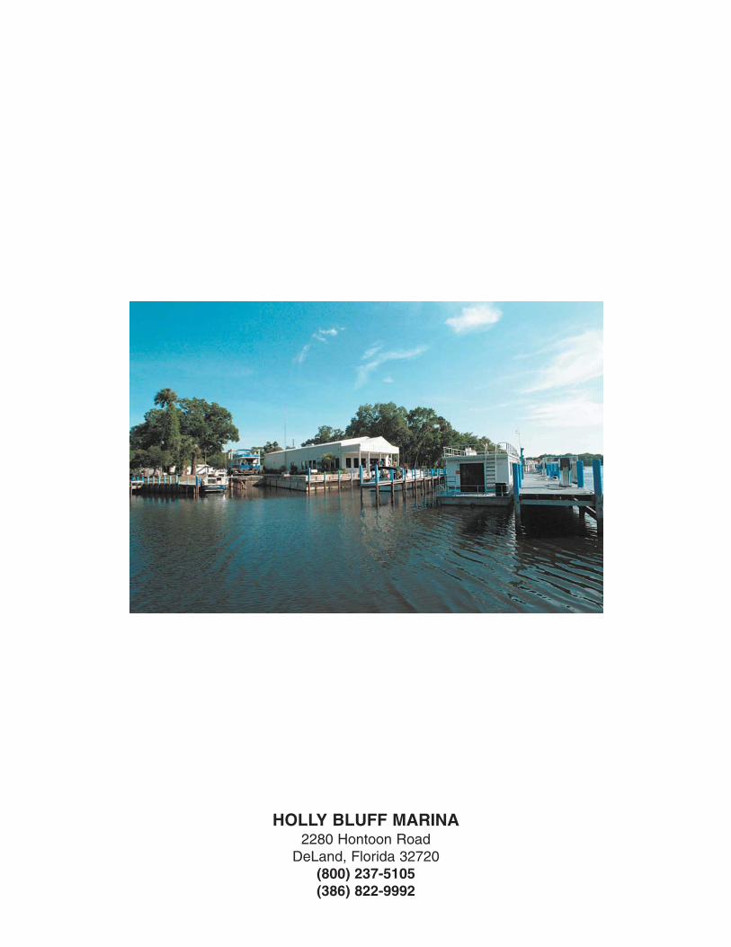
HOLLY BLUFF MARINA2280 Hontoon Road
DeLand, Florida 32720(800) 237-5105(386) 822-9992