h.m.s. beagle in tasmanian waters...each table is provided. h.m.s. beagle left on 30 january 1836...
TRANSCRIPT

Papers and Proceedings of the Royal Society of Tasmania, Volume 143(2), 2009 105
H.M.S. BEAGLE IN TASMANIAN WATERS
by Peter Charles Stevenson
(with two text-figures, one plate and 11 tables)
Stevenson, P.C. 2009(11 :xii): H.M.S. Beagle in Tasmanian waters. Papers and Proceedings of the Royal Society
https://doi.org/10.26749/rstpp.143.2.105 ISSN 0080-4703. 2/3 Yolla Street, Rose Bay, Tasmania 70 l 5, Australia. Email:[email protected]
143(2): 105-116.
A photocopy of the log ofH.M.S. Beagle from 1-22 February 1836 was examined and a transcription made from the handwritten script. The import of the column headings is explained, and comments are made on the course, navigation, the winds encoumered, the weather, the sail handling, and the ship handling during rhe period at sea, and while in harbour in Hobart Town. An attempt w,rs made to derive the synoptic weather situation. Key Words: Beagle, FitzRoy, Darwin, Hobart Town, sail handling, ship handling, Charles Darwin.
INTRODUCTION
Between December 1831 and October 1836 H.M.S. Beagle made her second voyage to South America and around the world. The voyage was occasioned by the recent revolutions in the former Spanish colonies in South America which had opened them up to trade, and the British Admiralty wished to obtain accurate positions of safe anchorages on the inhospitable coasts.
The Beagle was a barque of 242 tons specially equipped for survey work, and unusually she carried 22 chronometers for the more accurate determination of longitude (FitzRoy 1839). On the recommendation of her commander, Captain Robert FitzRoy, and with the support of the Navy's Hydrographer, Admiral Francis Beaufort, she carried a naturalist to record the natural history of the parts visited. The naturalist was an inexperienced amateur in his early twenties, Charles Darwin, who paid for the passage of himself and his servants. Darwin ( 1839a, b) recorded his observations and, with special reference to Tasmania, his observations have been extended in Davies (2009).
MATERIALS AND METHODS
Photocopies of the log of H.M.S. Beagle were obtained from the Public Record Office, now The National Archives, Kew, in 2000. The Beagle log for the entire five years of the Second Voyage, when Charles Darwin was on board, appears in the records as ADM 53/236. The period covered by the copies examined here was 1-22 February 1836. 1he logs are handwritten and there is little variation in the script. The ship was commanded by Captain Robert FitzRoy R.N. and Charles Darwin was on board, bur neither the captain nor Charles Darwin figure in the log. Four watch officers are identified, and the log appears to have been kept by Edward Chaffers, the Master.
DAY TABLES
General remarks
The Day Table is the unit of the log. Each covers 24 hours, is handwritten, and appears to be drawn up into columns with notations for each day. The handwriting does not appear to
change, as one might expect, and I interpret that the log was kept by the Master, Edward Chaffers. 'The Master usually kept a second copy of the log, and his copy has been used for the period 5-6-7 February. The handwriting is similar in this document.
The left-hand columns headed H, K and S are in accordance with Admiral Beaufort's "instructions" (FitzRoy 1839, pp. 32-42), and signify the Hour, the Speed in Knots, and possibly the state of the Sea, or the Swell. Enquiry of the Research Section of the Meteorological Office, Exeter, UK, elicited the response that they could not interpret this latter column heading.
The Course column which follows is indicated in compass points, there being 32 in the complete "Boxing of the Compass". Half points are used occasionally. The abbreviation "b" as in Sb W indicates "by'', and is given by a very small superscript "b". The Winds column uses the same compass conventions, and "Wly'' indicates "Westerly".
There follows the Wind Force using Admiral Beaufort's Wind Scale, and the Weather column using the admiral's Weather Letters, and appearing in the "Hydrographer's Instructions" (FitzRoy 1839, pp. 40-41). There appears to be an added "a" to the letters, not recognised in the Instructions. The letter is quite clear and is often used, but close examination shows it must be "c". Moreover "a" never occurs with "c". The letter "q", indicating squalls appears often, though it can be confused with "g". Squalls were regarded with some fear, sometimes described by Captain FitzRoy as "pampcros" (FitzRoy 1839, pp. 85-89), and in view of the reputation amongst the crews of the Cherokee Class ships to which Beagle belonged, as a "Coffin Ship" (Geddie 1959), this was perhaps wise.
Then follows the Sympiesometer column. This early air barometer was preferred by Captain FitzRoy as being less fragile and handier than a mercury barometer, as well as affording an Air Temperature reading in Fahrenheit degrees as well as pressure. "The Air Temperature had to be used as a correction before the air pressure could be determined. The figure given in the column is usually a decimal part of an inch, the whole number having been indicated earlier in the Day Tables. The Air Temperature follows. The next column poses a problem. The heading is very poorly written, but seems to be something like "Lee Sig". The column entries clearly are the initials of the Officer of the Watch, and appear two or three times in each 12-hour period. All of the initials have been recognised from the crew list.
106 Peter C. Stevenson
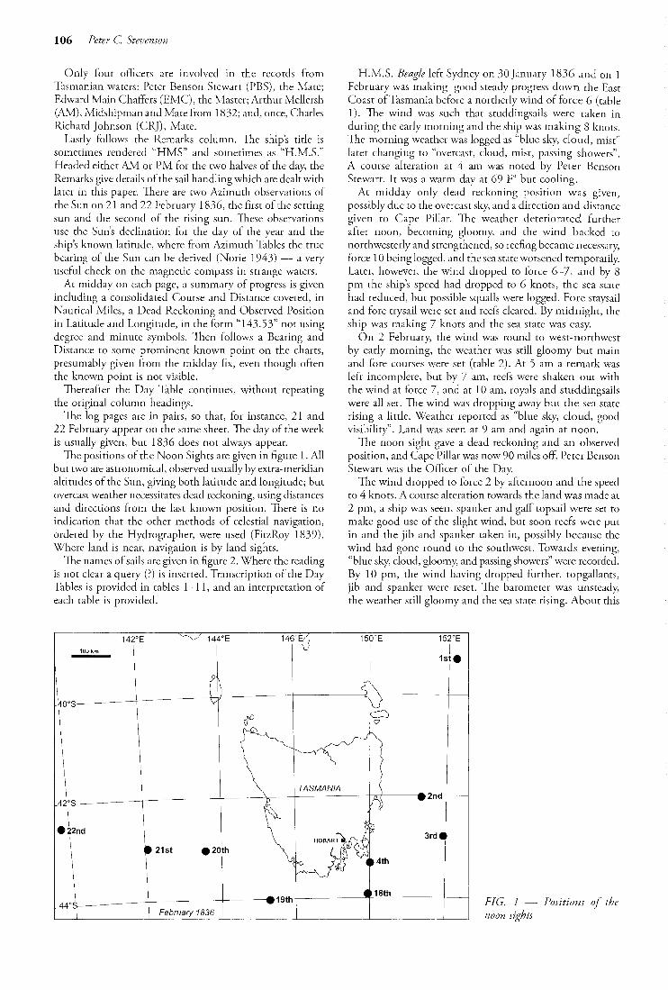
Only four officers are involved in the records from Tasmanian waters: Peier Benson Stewart (PBS), the J\-1ate; Edward Main Chaffers the Master; Arthur Mellersh (AM), Midshipman and Mate from 1832; and, once, Charles Richard Johnson (CRJ), Mare.
follows the Remarks column. 'The ship's title is sometimes rendered "HMS" and sometimes as "H.M.S." I-feaded either .M1 or PM for the two halves of the day, the Remarks give details of the sail handling which are dealt with later in this paper. There are two Azimuth observations of the Sun on 21 and 22 February 1836, the first of the setting sun and the second of the rising sun. 'H1ese observations use the Sun's declination for the of the and the ship's known latitude, where from Azimuth the true bearing of the Sun can be derived (Norie useful check on the compass in strange waters.
At midday on each page, a summary of progress is given including a consolidated Course and Distance covered, in Nautical Miles, a Dead Reckoning and Observed Position in Latitude and Longitude, in the form "143.53" not using degree and minute symbols. 'TI1en follows a Bearing and Distance to some prominent known point on the charts, presumably given from the midday fix, even though often the known point is not visible.
Thereafter the Day Table continues, without repeating the original column headings.
The log pages are in pairs, so that, for instance, 21 and 22 February appear on the same sheet. 1he day of the week is usually given, but 1836 does not always appear.
The positions of the Noon Sights arc given in figure 1. All but two are astronomical, observed usually by extra-meridian altitudes of the Sun, giving both latitude and longitude; but overcasc weather necessitates dead reckoning, using distances and directions from the last known position. Tnere is no indication that the other methods of celestial navigation, ordered by the Hydrographer, were used (FitzRoy 1839). Where land is near, navigation is by land sights.
The names of sails are given in figure 2. Where the reading is not dear a query (?) is inserted. Transcription of the Day Tables is provided in tables 1--11, and an interpretation of each table is provided.
H.M.S. Beagle left on 30 January 1836 and on J February was making steady progress down the East Coast ofTasmania before a northerly wind of force 6 (table l). 1he wind was such that studdingsails were taken in during the early morning and the ship was making 8 knots. The morning weather was logged as "blue Sh"f, cloud, mist" later changing to "overcast, cloud, mist, passing showers". A course alteration at 4 am was noted by Peter Benson Stewart. It was a warm day at 69 Fo but cooling.
At midday only dead reckoning position was given, possibly due w the overcast sky, and a direction and distance given to Cape Pillar. 1he weather deteriorated further after noon, becoming gloomy, and the wind backed to northwesterly and strengthened, so reefing became necessary, force 10 being logged, and the sea state worsened temporarily. Later, however, the wind dropped to foree 6-7, and 8 pm the ship's speed had dropped to 6 knots, the sea state had reduced, but possible squalls were logged. Fore staysail and fore trysail were set and reefs cleared. By midnight, the ship was making 7 knots and the sea state was easy.
On 2 February, the wind was round to west-northwest by early morning, the weather was still gloomy but main and fore courses were set (table 2). At 5 am a remark was left incomplete, but by 7 am, reefs were shaken out with the wind at force 7, and at 10 am, royals and studdingsails were all set. The wind was dropping away but the sea state rising a little. Weather reported as "blue sky, cloud, good visibility". Land was seen at 9 am and again at noon.
The noon sight gave a dead reckoning and an observed position, and Cape Pillar was now 90 miles off. Peter Benson Stewart was the Officer of the Day.
The wind dropped to force 2 by afternoon and the speed to 4 knots. A course alteration towards the land was made at 2 pm, a ship was seen, spanker and gaff topsail were set to make good use of the slight wind, but soon reefs were put in and the jib and spanker tal(en in, possibly because the wind had gone round to the southwest. Towards evening, "blue sky, cloud, gloomy, and passing showers" were recorded. By 10 pm, the wind having dropped further, topgallants, jib and spanker were reset. The barometer was unsteady, the weather still gloomy and the sea state rising. About this
l ..... ,-r ,7 r 146·Ej ir ::1: 40°8------- --------~---- ---~- ~~----------
~ ~~ -~~· I ~""- ~ "
- -------e-2nd ----
~
18 2\2od "'' e ,l "'-~~ I ~~ 1 , ----~-- ---19tl1 1---~-t~~-"_t_:--------- February 18~_l__ __ ~ ___ .L__ ____ _
3rd
FIG. 1 --~ Positions of the noon sights

time, Charles Darwin complained that the weather was "very cold and (Darwin l839b, p. 532), but as a poor sailor this may been an exaggeration.
On 3 February, the wind had veered to west by south at force 5, with "blue sky, overcast, (sic), gloomy, fog" (table 3). 'The course was now towards the southeast, then with failing wind, (force to east south. Reef~ were taken out and the gaff topsail set. 1hese were taken aback by a wind change and a risk of squalls; two reefs were taken in topsails, jib and spanker. The speed was now slow, 1-2 knots, and the wind variable. Wore ship, [by turning the ship through a large angle away from the wind instead of a small angle through the wind], to change tack, then set topgallants, jib and spanker, which were taken aback again in force 4 winds. Finally royals and flying jib were set, as if in defiance.
It must have been very trying. A detailed course can be constructed from the log, which shows that the ship was sailing north some of the time, but the inherent inaccuracies of this process show that an accurate plot is barely possible.
The noon position was given as 85 miles from Cape Pillar. The course was now southwest by south, a close-hauled course with the wind westerly. In force 2 winds studdingsails were set, but only to be taken in later with rising wind. Many course changes occurred in changing winds, but the wind was now veering to north northwest, and a course was taken to the southwest with spanker and gaff topsail set. The barometer was falling to 30 inches and below. Again Peter Benson Stewart was the Officer.
5, Fore course G. Fore topsail 7, Fore topgallant sail 8. Fore royal sail 9. Fore lower studdingsail 10. Fore topsail studdingsaH 11, Fore topgallant sail studdingsail
HM.S. Beagle in Tasmanian waters 107
On 4 the sail was reduced and reefs put in as the ship was dose-hauled five points off the wind (table 4). Jib and spanker, useful in this condition, were taken in and then reset. Topgallants were set and then taken in, but, with failing reefs were taken out. Land was sighted; Cape Pillar, Tasman Head and Cape Raoul were identified and with the wind veering to north-northwest, royals and flying jib were set but soon struck. 1he weather was overcast and rainy with a hint of squalls.
There was no noon sight. In failing and variable wind, there were many course changes, with speed at 2 knots and continued fear of squalls. Tacking and a difficult work to
windward occurred, with reds to topsail, and main, and spanker struck. Bearings to Cape Pillar and Cape Raoul running fixes, but rising wind split the fore topmast and required the bending on of another. Anomaious entries in the Signature column are of unknown significance. Again Peter Benson Stewart and briefly Charles Richardson Johnson were the signing Officers.
The description covering 5-7 February 1836 is taken from the Master's log (table 5).
With the wind northerly at force 6, and again with a hint of squalls, wore ship to change tack, and jib, spanker and topgallants were set. A running fix from the Capes was taken, and by 8 am reefs were taken out. The weather was overcast with some blue sky but gloomy, with squails and passing showers. This day must be that referred to by Charles Darwin when he said that "the weather justified this awful name" of Storm Bay (Darwin 1839b, p. 532).
12. Fore trysail i 3. Main course 15. 16. Main 17. Main !owerstuddingsai! 18. Main topsaH studdingsail 19. Main studdingsail
approx. 5
FIG. 2- Sails carried on HJivfS. Beagle. (After Marquardt, KH. 1997: Anatomy of the Ship HMS Beagle Survey Ship Extraordinary. Conway, Anova Books Ltd, London: 128 pp.)

108 Peter C. Stevenson
PLATE 1 Day Tables and 18 """'""a"" 1836 in the log of HM.S. Beagle. Het•ror;turt~d with fin·mt»w

HM.S. Beagle in Tasmanian waters 109
TABLE 1 Day Table of the log of H.M.S. Beagle for 1 February 1836
H =Hour: K =Speed in Knots; S = o State of the sea or Swell; Course, rneasnred in compass points, there being 32 in the complete '·Boxing of the Compass"; b =by; Wly =westerly; Wind Force measured by Admiral
Beaufort's Scale; Weather, recorded as Beaufort's weather Letters in FitzRoy 1839, pp. 40-41; q =squalls; Syrnpiesometer =barometric pressure; Air Temperature in degrees Fahrenheit; Lee Sig =''initials of the Officer
of the Watch.
HKS Course Wind F Weather Symp A temp L sig Remarks HMS Beagle Monday I·'' Feb
I 8 5 South AM 2 8 5 .. Nthly 6 b.c.m .96 69 3 8 3 2 In Course +TOt Stdng sails +Royals 4 8 3 5 8 2 SbW .91 69 3.20 ln Top (M) Stdng sails 6 8 2 7 8 2 .88 69 8 8 5 .82 69 4 A ltd Course to SbW 9 8 5 O.C.ITI.p PBS ( 108 5 " 7 .78 67 118 5 129 - .70 67 Course Dist Latitude Longitude Bearing + Distance S(b)W 197 Dr Obs Dr Obs
39.19 150.22 Cape Pillar SlOW 220'
86 SbW 9 o.c.g.m PM !.lOin Tgtsails 1"+2" reef Top sails 2 8 - 10 .75 68 Furled Main sail in Flying Jib Boom 3 8 - NW!y 4 6 4 7 5 8 5 .75 65 3.20 set rfs Main sail Main Trysai1 Jib and Tgt Sail 6 6 5 6 o.c.g .82 58 5 ln TOt sail Jib and Main sail Clear rfs 7 6 2 8 6 2 7 b.c.q.g .82 57 PBS Top sails + reef the Foresail down Tgt 9 6 2 in 2"" reef main topsails down fore trysails 1062 .90 59 6. 15 set fore staysail + fore try sail rf 117 2 9 out clear rfs of Topsails and reef of Foresai I 127 2 Nthly 6 b.c.g .88 58
TABLE2 Day Table of the log of H.M.S. Beagle for 2 February 1836
H =Hour; K =Speed in Knots; S =?State of the sea or Swell; Course, measured in compass points, there being 32 in the complete "Boxing of the Compass"; b =by; Wly =westerly; Wind Force measured by Admiral
Beaufort's Scale; Weather, recorded as Beaufort's weather Letters in FitzRoy !839, pp. 40-41; q =squalls; Sympiesometer =barometric pressure; Air Temperature in degrees Fahrenheit; Lee Sig =?initials of the Officer
of the Watch.
HKS Course Wind F Weather Symp Air ** Remarks to HMS Beagle Tuesday 2nd
I 8 - SbW 2 8- WNW 7 b.c"g .89 57 AM2 up Main sails + up the Foresail 3 7 - 8 4 7 - 9 .90 57 5 set 5 7 8 6 7 - .92 56 7 7 4 7 out 3'" rl of Topsails 8 crossed Tgt yds out rf 8 7 4 7 .94 56 of Mains] & Trysl, set Jib & Tgt sail 8.30 out 9 7 - 2"d rfs Obs land on W beam 9 out alllfs 106 5 5 b.c.v .92 56 10 set Starbd Top M Stdngsails 10.40 set Royals 116 - Flying & T.Gt Studding sails 125 6 4 .88 56 PBS 12 Extremes of land WbS & WbS to S
Course Dis! Latitude Longitude Bearing and Distance Dr Obs Dr Obs
SbyW 169 41-56 42-01 149-11 149-21 Cape Pillar S45W dis! 90'
l 65 SW NWly 2 y, 8 SWbS NWly 2 b.c .87 60 PM 2.15 altd course Trimmed sails set Spanker 3 3 5 & gaff tops! Obs a ship on lee beam standing to North 4 4- 2 b.c.g .91 59 4.30 in Tgt sails and Gaff Tops] I "&2nd rfs of Topsls
5 4 5 SEhS sw 4 o.c.g.p 6 4- .84 57 7.20 down Jib & Spanker in 1st rf Mainsails 7 4 5 SE I 0 set Tgt Sails Jib and Spanker 8 4 5 6 b.c.g.p .92 55 % 9 4 5 11.30 in Ditto 104 2 ssw 5 b.o.v .94 55 115 6 125 5 b.o.g .85 55 PBS

llO Peter C Stevenson
TABI"E3 Day 'fable uf the log ofHJVf,S. Beagle for J Fch:ru~~r.Y 1~36
H Hour: K::.: Speed in Knots; S::::? State of the sea or S\vcll; Course, me<Jsured in compa:~s points, there being )) in the '·Boxing of the Compass''; b =by: \Vly = 'Nesteriy; \Vind Pon~e rneasured b:y Adrn1ra1
Berwft)tt's Weather recorded Beaufort"s vvcather Letters in FitzRoy 1839._, pp, 40--41: q = squalis: Sympiesometer::::: barometric pressure; Air Temperature ln degrel~S Fahre-nheit; Lee Sig ? initials of the Officer
C>f the \Vatch.
3 4 -4 :; 5
3 6 l 7 1 s
SE EbS
4 b.o.g
o.c.q
3 2 SWh\V? Vble - o.c.q.p 24
9 I SWbS 101 2
4 NW 4 b.c.g? Ill NNW 122 ssw
S16E s~· . ' 42 . .55 42 .48
1 42 SWbS Wly'' 2 2 5 2 b.c 1 25 sw 4 36 WSW 4 5 7- SWbW 6 7 8 7 8
8 74 NbE 5 b.c.g 9 37
38 WSW 105 5 2 b.c 113 5 sw NNW 123 5
.20 51
.20 54
.24
.22 56
149 .53
.15 56
.08 58
.12 58 set
10 Coarse? .84 58
.76 60
.71 60
There was no noon sight as land was and the rest of the was given as "working up Storm Bay and standing up the Derwent". The lighthouse at the Iron Pot was noted at 2.20 pm.
Wind was variable, and short sail was made "as requisite to . Such capfuls of wind are very common in summer as the air off Mount Wellington, and to
this day catches ships, large and small, unawares. Sullivans Cove was entered at 6.40 pm, and mooring was
completed with 30 fathoms of cable from bow and stern. H.M.S. Beagle was moored in the cove but not laid alongside, there being no established wharf. 1he expression "B.B." appears, and is taken to mean Best Bower, the starboard bower anchor and the best anchor in the ship.
1he next days, from 6--16 February, potentially were of great interest, since they are the days when Charles Darwin was recording his important observations concerning Tasmania (Davies 2009). lfowever, the log entries record
the merest outline of activities such as "harbour duties", or variously on ship's duties'. On nearly every day the entry "received 69 lb of fresh beef and veg." appears and one may speculate this particular quantity was delivered each day. "Wood" is given on one day, presumably as fuel for the Cook. On Sunday 14 February at 10 am the crew was "mustered by divisions", for Divine but at 5 pm the topgallant were the work of the ship had to go on. On this day also, Darwin wrote to his sister Catherine to the effect that, "there never was a
PBS
100
J set Tg s<tih Jib+ spanker 2. Do. to a squall 2.30 set _Do< 5 out reefs of Ma1n S-! n:cJc; of Top Sis _)_set
Gaff TupSl 5.30 Tacked 5 'Taken aback \Vi.th the \Vind from the SW on Starbd tack in T .Gt sn.Jls I sr and Spanker
6.J 5 Wort 7 set TGt Sails Jfb and Spanker 8. out all rfs 8.40 Tacked 9 .I 'i Taken aback 10.15 Tacked set Royals and Flying Jib
Pilhr S74W S5
Cape Pillar S74'W 85 miles
PM 3.30 Trimmed set Strbd Topmast
and T.Gt Studdingsails 5.20 in TGt Studding Sai Is and trimmed
6.30 down F Top Staysails + Trysails
10 Trimmed Sails in M. Studding Sails set Spanker and Gaff Top
so full of homesick heroes as the Beagle" On Monday 15 February, the topgallant masts were re-
erected and the "crossed" on the following day. On this same February 1 Lieutenant Duff of the 21st Regt. was embarked "for passage to England".
It is noteworthy that the Wind, Force, Sympiesorneter, and Air Temperature readings were scrupulously observed for every day in harbour. 1he value of this information as a of the future was probably in the mind.
The 11 1836 with the reception of207lb ship was then hove short on
B.B., the Best Bower anchor. At 9 am anchor was and all sail made to The weather was still gloomy. The vvind was variable and force 1, and towards noon, passing showers fell. 1he wind was now northwesterly and variable, not atypical for Hobart. After noon (no sight), the ship was tacking in rising wind which was now southeasterly but still variable, required lowering and topgallants, first and second reefs were taken in The Iron Pot Lighthouse was passed at 2 pm, and were taken out in failing wind. 1he course was now southeast and a bearing was made of Cape RaouL At 11.15 pm the courses (main sails on both masts) were set and trysails taken in. 'Ihe land vvas lost at J 0.30 pm in the the ship having made 20 miles or so to the seaward. Arthur Mellersh, Peter Benson Stewart and Edward Chaffers were the Officers
6, 1).

H. MS. in Tasmanian waters 111
TAIJLE 4 Day Table of the lng of H.M.S. Beagle for 4 February 1836
.H = Hot1r; K ::::.Speed in Knob; S -:._?State of tbe sea or Swe!l: Coursl.'.\ measured !n compass points., there being 32 in the complete "Boxing of the Compass"; b =by; \V!y =westerly: 'Nind Force measured by Admiral
Beaufort's Scale; Vleathcr, recorded as Reat1fort's weather Letters ln Fit:t.Rny 1839, pp, 4-0-A 1; 4 =squalls; Sympiesmncter "_:-:barometric pressure: Air Temperature in degrees Fahrenheil; LBe Sig :::" ? initials of the Officer
of the Watch.
J -4 4.
6 4 -7 3 S WSW 8 4 5
SWbW NbW NNW
.65 58 PBS
.64 58
4 b.o.g .66 56 ,. 5
4 .64 56
Dr Obs Dr
------·--·----·
saw the land NWbW set Jib and Spanker + TGt Sails 430 In TGt Sis
6.50 out 2nd rff; + set TCH sails + Gaff Topsail Cape Pillar NWbW Tasman Head N9W
Cape Raou! N56W 9 Tl<d. 1! .30 set Royals+ Flying Jib 12 in Do.
! I 5 West PM 2 SW Vble
2 2 2 25
3 4 5 24
NW
4 3 2 SSWWestly
56 1.30 Tacked in 2nd reef of Topsails
1.50 om Do. 3.30 Tacked Shortened
5 2 5 South 5 .62 56 CRJ Sail as requisite to squalls 3 NWbW
6 4 8 NW 56 PBS 4.30 tacked 6 tacked in Top Gallts 7 Working to Windward 8 l 8 ssw
SWWNW
+2"d reef oftopsails + 1" of M. Sail Down Jib + Sparlker
9 2 8 102 113 2
b.c.q .74 50 1; 6 Cape Pillar N51 E Cape Raoul NSOW Y, 8 Cape Pillar N34E 9 the F.T. Mast
Stays! unbent +bent 123 6 6 b.c.q .72 50 Y, 12 Cape Pillar SSW '14m Cape Raoul N Y, W
On 18 February, the ship was becalmed at 2 am, but the course was laid south before a fitful northerly and rising wind to become south by west by 7 am. All sail was made including studdingsails, and trimmed, and the course maintained, making 5-6 knots (table 7, 1).
The noon sight gave a position and a bearing to an unidentified "Ruisck Rock", but the position suggests that this was Pedra Branca, 23 krn off South East Cape. With the wind to 6, the studdingsails were struck. The course was now west south before a light northerly wind. Land was seen northwest by west to north northwest. Ihere is high ground in Southwest Tasmania, and this would be visible at a distance of perhaps 50 miles. At 7.15 pm "Peak to Sugar LoafN25W" is recorded. A rough plot using known positions and recorded distances through the water shows this bearing passes through Federation Peak, a prominent point at 1224 m. With the wind still light, studdingsails, royals and flying jib were set, the Beagle was making 5 knots, the course being still west by south.
On 19 February the course was maintained west by the wind was still light and variable horn north to
east. fJI day the sails were set and trimmed to try to get more speed. The weather was overcast, with rain and mist, and a noon sight was not possible, but a position was given by dead reckoning, estimating South West Cape S56W at 52 miles (table 8). This must surely be a mistake, as this would put the ship somewhere in the mountains ofWestern Tasmania. If the reciprocal bearing of N56E is accepted,
Tas1nan Hd \VbS Y2 s?
then this puts the ship very dose to the dead reckoning positiono 'This mistake would hardly mean anything to the navigator on the ship, but looks very strange to a subsequent historian. The consolidated Course of S89W and the Day's Run confirm the true position.
In the afternoon, the course changed round as far as east with continuing dull rainy weather, but rising wind, to force 7, required reefs to be put in, and the striking of royals. 7 pm the wind had gone to south so a course west by north was laid. A rising barometer was recorded.
By 20 f'ebruary, southeast and variable winds enabled a course approximately northwest to be maintained and reefs were taken out in force 4 wind. Changing winds to
northwesterly made tacking necessary, not usual at sea. A noon gave a position: with Point Hibbs estimated at N72E 105 miles. 'The course was changed to south·-southwest in the face of northerly winds (table 9).
In the afternoon the wind at force 4 became squally, reefs were taken in topsails, and the weather remained gloomy and rainy, but the wind going to south-southwest made the sea state change to rough for a time.
\Vith the wind from south-southwest on 21 February and the course nearly four points off at west by north, reefs were taken out and royals and flying jib were set. Even in light winds, 3-5 knots was attained at times. Mustering for Divine Service did not prevent the wind dropping to fOrce 1-2 and vdlldlllc. and a noon sight gave a position and a distance of 188 miles from Kings (sic) Island of 188 miles (table 10).

112 Peter C. Stevenson
TABLES llay Table of the log ol' H.M.S. Beagle for 5, 6 and 7 February 1836 derived from the second copy of the log
kept by the Master, Edward Chaffers H =Hour: K =Speed in Knots; S =?State of the sea or Swell; Conrse, measured in compass points, there being
32 in the complete "Boxing of the Compass"; b =by; Wly =westerly; Wind Force measured by Admiral Beaufort's Scale; Weather, recorded as Beaufon's weather Letters in FitzRoy 1839. pp. 40-41; q = squaJJs;
Sympiesometer =barometric pressure; Air Ten1peraturc in degree~ Fahrenheit: Lee Sig ='!initials of the Officer of the Watch.
HK S Course Wind F Weather 3 5 SW')
2 3 5 NNW? Nthiy 6 3 4 5 4 5
7 8 9 10 11 12
Working up
Storm Bay
Course Dist Latitude
o.c.q
b.c.g
DR Obs
Remarks to HMS Beagle Fcby 5-6-7-1836
AM I Wore ship 4. Cape Pillar NEbEY:!E & Cape Raoul NNEY:!E
4.40 set Jib Spanker +Top Gallt Sails
R. Tkd out 2nd rfs of Top Sails Quoin R*
NNW2' Tkd as reqte Working up Storm Bay
l"ongitude Bearing and Distance
DR Obs
-:-:-~-:-:----::-----------------:::::c-:W=o:-rk-:-I-"·ng, up Storm-::B:-ay7.--· PM Tkd occasionally Working up Storm Bay 2.20 Pass' d the Light house
!Working up Storm 2 Bay West? 5 b.c.q.p 3 & 4 Standing up tbe Yble 4 c.p Made + Short Sails as reqtc to squalls 5 Derwent 6 7 8 M-oored in Sulivans 9 10 Cove II 12 Hobart Town
Nthly Moored
Off Hobart Vble
TO\VH
Sthly
c.p
4
2 b.c
4 b.c.q .. p
Standing up the Derwent+ working up to Sulivaus
Cove 6.40 Short Sail + carne to in I 0 fams with B. B. Furled sails + moored ship 30 fams
each way
AM 6th 6.0 Cu*** +loosed sails
I 0 Furled sails Received 69 lb Fresh Beef + vegetable
PM Empd as requisite
TABLE6 Day Table ofthe log of H.M.S. Beagle for 17 February 1836
H =Hour; K =Speed in Knots; S =?State of the sea or Swell; Course, measured in compass points, there being 32 in the complete "Boxing of the Compass"; b =by; Wly =westerly; Wind Force measured by Admiral
Beaufort's Scale; Weather, recorded as Beaufort's weather Letters in FitzRoy 1839, pp. 40-41; q =squalls; Sympiesometer = barometr[c pressure; Air Temperature in degrees Fahrenheit; Lee Sig = ? initials of the
Officer of the Watch.
HKS Course Wind
1 2
Moored 4 5 Sngl 'J !Yble 6 7 Sh? 8 9 NWiy 10 Working out 11 of the Derwent 12 River Yble
l Working out 2 of the Derwent Vble 3 + 4 5 Storm Bay 6 SEly 7 8 6 SE Yblc 9 6 SE 105 ES 113 121 ENE
F Weather Syrnp T air Stg
30
b.m.g .05 60
2 c.g.p .11 591h
2 b.c.g.m .14 59 _____ , ____ ----------
o.c.g.p 4 .18 60
b.c.g .17 58 AM
5 .34 57 PBS
4 b.c .40 55EMC
2 .40 55
.38 55 AM
Remarks H.M.S.Beagle Feby 17th
AM Received 207 lb of Fresh Beef+ vegls Trimmed?+ hove short on B.B. 9 Weighed and made all sail to Royals
Tacked Trimmed made and shortnd sail as reqte working out of Derwent River
Be11ri ngs and Distance
Working out of the Derwent
PM Tkd as reqte working out of the
Derwent 2. Passed Iron Pot Light house 2.30 g? in Royals+ Tgt Sails 1 "+2"d rfs of
Topsails 3 out reefs set TGt Pts? + Tkd
6.0? Cape Raoul E (b0) S 1 Y,'
I 0.30 Lost sight of the Land
ll.l5 up Courses + down Try sails

H.JvLS. in Iasmanian waters
TABLE I Day Table of the log of H.M.S. Beagle for IS February 1836
H:.::: Hour: K =Speed in Knots:. S :::::'<'State of the sea or Swell; Course, measured in con1pass points, there being 32 in the complete ''Boxing of the Compass'···: b =by; V•liy westerly; Wind f•'orce measured by Admiral
Beaufort's Scale: 'Weather, recorded a~ Beaufort's weather Letters in FitzRoy 1839, pp. 40--41; q =squalls; Syntpiesomcter =barometric pres~ure: Air Temperature in Fahrenheit: Lee Sig ~? inltials of the 01Iicer
HK S Course Winds
2 0 Calm 0 At.oS
Nthly 2 SonLh
6 7 2 4
9 4 5 105 5 1!6 126 6
Course
2 6 5 3 9 2 4 9 5 9 6 8 6 7 7 6 8 7 9 6" 106 5 114. 123
SbW
NE
Dist
43.58
WbS North 6
5 2
" 2
2
"
b
O.C.lTl
43.58
b.( .m
b.cm.g
..
--
of the
Air Remarks HMS
.36 57 AM
.33 57 daylight smv the Land Brg NW
.3K 56J'S Trin1n1ed +made all sail with Siuddingsai}s 40 57EMC
.40 55 Jl set Starbd Fore Lov./er +Sid LwrTopGt Studding Sails
---------+Distance
148.05 147.58 Ruisck o Rock s 82 w 9'
PM .26 56 In Port Studng Sails+ Starbd TGt Do. Trimmed
.21 58 PBS + Alto Co to WbS set Stbd Fore Top Lwr. Studg Sails+ Jibs 2. Tn Royals Plying
.16 57 Jib+ M Top Stb·l Stud Sl 3 in Fore Top Gt Do. 5.10 saw the Land BemgNW
.10 58 AM 6 Land from NWb W to NNW 7. 15 Peak t Sugar Loaf N 25 W
.04 68 set Fore Top Mts'' Studng Sail Royals + Flying Jib 29 .98 59
TABLES Day Table of the log of H.M.S. Beagle for 19 February 1836
H = Hour; K =Speed in Knots; S =?State of the sea or Swell; Course. meaSL1red in compass points, there being 32 in the complete "Boxing of the Compass"; b =by; Wly =westerly; Wind Force measured by Admiral
Beaufort's Scale: Weather, recorded as Beaufort's weather Letters in FitzRoy 1839, pp. 40-41; q =squalls; Sympiesometer c barometric pressure; Air Temperatnre in degrees Fahrenheit: Lee Sig = 0 initials of the Officer
of the Watch.
HKS Course Winds F Weather Symp Air Sig Remarks re J:IMS Beagle Friday Feb 19'1'
I 4 WbS Nrthly 29. 2 4 2 o.g.d .92 57 AM in Fore Top Mast Studding Sail Royals 3 2 +Flying Jib 2. Trimmed 3.20 Trimmed+ 4 2 " NWiy o.n? .90 50EMC made all sail on Strbd Tack. Daylight 5 I Vhle I 6 I 5 Ely 2 o.c.r.m .90 58 saw the Land Bg N'hW to NNE 7 32 4 o.g.m set Royals Flying Jib Stbd Top M+TGt Stuns] 8 52 NbE " .92 58 AM 9 4" set Fore Trysail 103 5 " NEiy 2 o.d .86 57 9.45 Trimmed+ set Stbd Lower Studding Sail J 13 6 124" 4 o.r .87 59 PBS
Course Dist Latitude Longitude Bearing & ,DjstwJce
DR Obs DR Obs
S 89"W J 19' 44.07 145.14 SWCape S56W 52"
1 1 WbS 2 "8 West North o.c.p .86 57 PM 3 "8 WSW 1 A ltd Course to West 3 .10 braced round to Port 4 2 8 East - - 4 -- .86 56Y, 5 7" 4.40 Tn Royals+ Flying Jib 6 7 4 So.c.rn.p.g .95 52 AM 7 8 8 .. South PBS 5.20 lnl'' +2"d rfs of Top Sails+reefofMn Sail 8 54 - -·-·-- ---- 7 o.c.rn .98 52
3 WbN? + 1" of Spankcr 9 8" - - 30 106 8 " 6 b* .06 53 116" 9.30 Trimmed 126" - - " 5 o.c.g .08 53EMC
113

114 Peter C. Stevenson
TABLE9 Day Table of the log of H.M.S. Beagle for 20 February 1836
H = Honr; K::::: Speed in Knots; =?State of the sea or Swell; Course, measured_ in corn pass points_ there being 32 in the ·'Boxing of the Compass'': b =by; Wly =westerly: Wind Force measured by Admiral
Beaufort's Weather, recorded as Beaufort's weather Letters in FitzRoy 1839, pp. 40.-41; q o• squalls; Sympicsometer:::: barometric pressure; Air Temperature in Fahrenheit:. Lee Sig =?initials of the Officer
of the
HKS Course Winds F Weather Symp Air Sig Remarks re H .M 5. Beagle Saturday 20'" 58 WNW SE
2 48 NWbW o.c.g .08 52 AM
45 NW Vble
4 4 . - .08 52 AM 6 2"d ri' of Main Sail out
5 5 NWbW 6 54 . . 4 ... D8 54 10 out 1 ~r reefs of Top Sails 7 5" 8 57 ".N?NW .10 54 10.20 Tacked 9 6" NNW 105 8 NVzW .12 55
2 North
115 2 SSW ..
125 "SbWVzW b.a. 10 55
Course Dist Latitude Longitude Bearing + Distance
DR Obs DR Obs
N67W 110 43.23 43.03 142.55 143.35 Est? Pt Hibbs N 72" E 105'
1 48 S\VbS PM 2 4 5 NE'? 4 o.c.q .10 54 3 4" 4 4" .. 4 o.g.q .07 54 AM 5 5" 6 5" .08 54 in 1" reefs of Top Sails 7 4 6.45 Tacked
1 " West 8 4 2 .. 4 o.g.q.p .14 54 9 3 5 103 8 WbN SSW .15 57 114 4 b.c.p 125 b.c 20 57 AM
TABLEIO Day Table of the log of H.M.S. Beagle for 21 February 1836
H =Hour; K =Speed in Knots; S ='?State of the sea or Swell: Course, measured in compass points, there being 32. in the complete "Boxing of the Compass": b =by; Wly =westerly; Wind Force measured by Admiral Beaufort's
Scale; Weather, recorded as Beaufort's weather Letters in FitzRoy 1839, 40-41; q =squalls; Sympiesometer = barometric pressure: Air Temperature in degrees Fahrenheit; Lee Sig = initials of the Officer of the Watch.
HKS Course Winds F Weather Symp AirT Sig Remarks re 1-!MS Beagle Sunday Feb 21" 1836
1 5" WbN SSW 4 b.c? .16 52 AM 2 5" 3 5" 2. out 1st reefs
4 52 . . .. .19 52 5 5" 6. set Royals + Flying Jib 6 4
l WbS .28 51 7 4 5 8 5" West -. 2 32 67? EMC 10.20 Mustered by Divisions 9 3 5 NbW 103 5 WNW Vble . - .32 51 113 3 122 5 o.c .3251 AM
Course Dist Latitude Longitude Bearing + Distance
DR Obs DR Obs
N88W 86' 43.00 42.55 141.37 142.03 ** Kings Is. Strd? N25E188'
1 1 8 West SSW PM 2 3" WbN Vble 2 b.c .32 51 3 2" 4 17 West .3252 PBS 5 J 7 6 2" - - .43 55 7. (o) set s 56"50' w 7 2" SSE 7.15 Trimmed+ set Port TGt Studd SP? 8 2 8 .. 2 . . .34 52 AM Fore Top Mast Studding Sails down F Trysail 9 2 5 9.30 Trimmed down Trysails + Spanker 102 5 ... .30 53 set Fore Course+ Top mast Studdng Sis 112" down Jib 122 2 SEly 0 .30 53

HM.S Beagle in Tasmanian waters 115
TABLE II Day Table of the log of H.M.S. Beagle for 22 February 1836
H::.: Hour: K =Speed in Knots; S ? State of the sea or Swell; Course, measured in compass po.ints, there being 32 in the complete "Boxing of the Compass"; b ~by; Wly = Wind Force measured by Admiral
Beaufort's Scale; Weather, recorded as Beaufort's weather Letters in 1839, pp. 40--41; q =squalls; Sy1npiesometer:::.: barmnetric pressure; Air Temperature in Fahrenheit; Lee Sig =?initials of the Officer
of the
HKS Course Winds F Weather SyrnpThrrn AirSig
I 3" West 2 34 " Eastly 2 b. .32 5! 3 3" 4 -' - - .l2.'i 1 EMC 5 38 6 4 5 2 - - 37 51? 7 4 5 8 4 7 - - "b.c .41 52 AM 9 58 106" - - 4 .37 54 116 6 126 8 ENE 4 -- .34 54 PBS
Course Dist Latitude Longitude
DR Obs DR Obs
W8l 81, 42.40 42.29 139.53 139.48
I 68 West 2 7 5 " ENE 4 b.c .30 55 3 8" 4 7 5 4 -- .29 55 5 75 6 7 6 - - -- .26 54 7 8 8 8 9 2 - - 7 b.c.m .18 55 9 84 108" .22 55 118 5 128 3 5 o.g.m .11 55
At 7 pm an Amplitude observation of the sunset gave a true bearing of S56o50W to enable magnetic bearings Lo be corrected. Winds remained light but southeasterly and sail changes tried to get the best out of force 1 and 2. The weather was dearer with blue sky and clouds.
AM
PBS
EMC
A course to the west was held on 22 February with winds easterly and slowly rising. The weather remained fair (table 11). Another Amplitude observation of sunrise gave a true bearing of S 83°E. Sails were set in force 2-4 winds. A noon sight gave a position and a distance from King Island of 230 miles at NSlE. At 7.30 pm rising wind carried away the starboard main topmast studdingsail boom, prompting all studdingsails and royals to be struck and the ship was now making 7 or 8 knots with a following wind.
DISCUSSION
From these interpreted remarks, one is constantly made aware of the complete reliance of the voyage on the wind and the weather, and the constant demands of the crew to go aloft night and day to handle the sails. There is a sense that the crew was trying to hurry the ship along, but taking care to
respond carefully to squalls.
Sail handling
Sail handling on such a vessel as Beagle is very much the creature of the wind and intended course directions. It is instructive to compare these two directions on a compass rose (a circular diagram representing the 32 "compass" points radially). This reveals the extent to which the ship is "close-
Remarks re HMS Beagle Monday 22n~l
AM 3. Trjmmed Sails 5.35 (o) rose S 83'E
6.20 set Stbd Fort Course+ Stbd? Top Mst Studng Sails up Mn Sail 9.30 Shifted? over Studding Sails
Bearing + Distance
Kings Is. Str'' N51 E- 230'
PM
7.30 Carried away StbJ Main Top Mt. Studg Sail Boom In all Studding Sails
+Royals
9 Trimmed
hauled", that is, how much she is made to sail into the wind. Tne changes made to the rig before the ship left England, namely the addition of a mizzen mast and a spanker sail enabled her, together with the carrying of inner and outer jibs and staysails, to be sailed to some extent as a "fore and aft" vesseL She would then be able to sail closer to the wind and be more controllable in difficult conditions. "!he fore and aft sails would also require much less manpower and would also be safer, as the crew would not need to go aloft, as square sails would require.
The urgency of the return to England is evident from the frequent use of studdingsails, additional sails set out on either side of the square sails. Just a few more miles in the day made the extra effort and risk worthwhile, At the same time prudent first and second reefs are taken, it is not worth taki~g too much risk and losing the ship towards the end of the voyage.
For example, on 3 February 1836 at 5 am the ship was taken aback, that is, a change of wind fell on the forward sides of the square sails, a distressing situation. A course change gave some relief, and ultimately wearing ship, that is, changing tack by turning away from the wind, did not prevent it happening again at 9, 15 am, Finally the wind resolved itself and serene sailing resumed. By the afternoon, staysails, trysails, and spanker and gaff topsails were all in use, that is, all fore and aft sails.
Late on 4 February, in the dark, when south of capes Raoul and Pillar, the fore topmast staysail was biown out and had to be replaced. After more than four years at sea, it is unlikely that any sails were new.

116 Peter C Stevenson
The weather
1he weather during the Tasmanian pan of the ts
given in the Meteorological Observations in Volume of FitzRoy (1 The entries but there is more immediate detail in the log.
Ian Barnes-Keoghan of thc Hobart Office of rhe Bureau of Meteorology (pers. comments as follows: "6-17 February 1836, Hobart T!)wn The reported weather through this time seems not of a Hobart February: temperature in the teens, generally "fine" weather, but with a
On Beagle's arrival in Hobart, the winds are and variable, weather clear (though with some cloud), and the pressure moderately high (as would be expected with a high pressure system nearby) , temperamre 10 or 11 oc (although these arc mostly taken at 9 am, so such low temperatures are reasonable).
There appears to have been a cold fi-ont crossing between 4 pm and 9 pm on 14 February. 1he 4 pm was 24oC, with the wind strengthening north to
northwesterly (it reaches force 7), and the barometer steadily. By 9 pm the wind has shifted lightning is reported. The next morning finds the temperature around 13oC and the weather "gloomy". The reports do not make any mention of rain during the period, although it is possible this fell at other than an obserntion time."
An examination of the weather reports of the entire 22 days of the record enables some other comments to be made. The abrupt change of temperature, the squall indication, the "gloomy" remark, and reefing at 5 pm on 1 seem to indicate the passage of a cold front. High barometer and more "gloomy" comments on the following may represent a summer-time high, as does the change wind to the south-southwest.
Variable winds on 3 February, which require some manoeuvres attended by squalls, precede the re-establishment of northerly winds late in the day. On 4 February blue skies and at the same time overcast and gloomy weather are recorded, and may perhaps indicate mountain waves in the wake of the Tasmanian mountains, weather on 5 February may be indicative of the sudden gusts PvtwrtPn
close to the Tasmanian mountain coasts, Taking up the story on 17 February, light northerly
winds and a change to southeasterly hampered to the seaward from the Derwent, and on 18 a calm sea presaged a rising northerly, falling barometer. This continued to fall on 19 February with variable and easterly enabling quicker progress to be made at the end of the day. A late rise in the glass and another change of wind from east to north and then south must have made the crew wish for the open sea and more consistent winds.
This wish was not fi1lfilled on 20 or 21 February with more continuing light and variable winds, squalls again indicated, and the ship clawing to the northward. But on 22 February the easterlies improved, and better progress was made, even to the extent that a studdingsail boom was carried away as the ship set course for King George's Sound in Western Australia.
There appears from the density of weather information that synoptic situations could be derived from it, but this remains to be attempted.
An
'While in p.
movements in Tasmania very notes that Darwin was
to FitzRoy and that their stay, Darwin was free to do not required to attend dinner with the
is well,md is
came in or ate out. 'These actions may mark the FitzRoy's absence. Given rhe few comments made about midland Tasmania and his aristocratic connections it seems likely that he visited, or was invited to stay with, the local members of class Tasmania in rhe between Connorville Fingal in northern Tasmania.
Where did he go, and who did he see? enquiries have revealed no answer so far.
ACKNOWLEDGEMENTS
Thanks are due to the following: Prof. IVfichael Hoc, for encouragement and the loan of the Master's Log; of the sail ship for discussion of sail handling; Ian
June the illustrations and Dr Margaret Davies, for her enthusiastic encouragement.
REFERENCES
FitzRoy, R. Majesty's Ships Adventure between and 1836, Describing their Examination of the Southern Shores and the of the 3 vols and Colburn, London: 2862 pp,
Geddie, W. 1959: Chamber's liuentieth & R. Chambers Ltd, London &
Node, J .W. 1943: Nories Nautical Tables. Wilson, London: 7.35 pp.
;"',cn~•nrl .3 November 2009)