historic landscape analysis physiography - vaughan · old), sarah (16 years old), and jane (14...
TRANSCRIPT

City of Vaughan Official Plan Cultural Heritage Landscape Inventory and Policy Study Page 22
3.0 Skandatut-Kleinburg Cultural Heritage Landscape Case Study 3.1 Introduction The following sections provide a case study analysis of the Skandatut archaeological site and Kleinberg Ossuary as a cultural heritage landscape. The Skandatut archaeological site represents a two hectare early contact period village and is located on the summit of a promontory overlooking a tributary of the East Branch of the Humber River. This site is located approximately half way between Teston Road and Major Mackenzie Drive west of Pine Valley Drive. The Kleinburg Ossuary is located approximately 600 m west of the Skandatut site and was excavated in 1970 and found to contain the remains of 561 individuals. Section 3.2.1 provides a historic landscape analysis of the area included within the proposed boundary of the Skandatut-Kleinburg cultural heritage landscape. This section traces the historic landscape development of the subject area through examination of land use themes which have been identified as significant in the City of Vaughan. This review examines the physiographic characteristics of the study area and also traces various layers of landscape change that have occurred within the study area. This analysis provides a framework for understanding the site’s full range of cultural heritage values and identifying associated heritage attributes. Section 3.2.2. describes the area’s archaeological and natural heritage resources and sensitivities, as based on the results of previously conducted archaeological investigations and a pedestrian survey of the area in December 2009. Following, Section 3.2.3 presents a preliminary analysis of the site’s cultural heritage significance and associated heritage attributes.
3.2.1 Historic Landscape Analysis
Physiography The majority of the study area is located within the Peel Plain physiographic region of southern Ontario, with the extreme northern edge of the study area situated at the interface between the Peel Plain physiographic region and the South Slope region to the north (Chapman and Putnam 1984). The Peel Plain physiographic region covers a large area across the central portions of the Regional Municipalities of Peel, York, and Halton. The surface of the plain is characterized by level to gently rolling topography, with a consistent, gradual slope toward Lake Ontario. The plain is made up of deep deposits of dense, limestone- and shale-imbued till, often covered by a layer of clay sediment. While the clay soils of the plain may be imperfectly drained in inter-stream areas, the region is without large swamps or bogs. Several major rivers and numerous smaller streams cut across the plain, draining southward into Lake Ontario. The South Slope physiographic region (Chapman and Putnam 1984: 172-174) is the southern slope of the Oak Ridges Moraine. The South Slope meets the Moraine at heights of approximately 300 metres above sea level, and descends southward toward Lake Ontario, ending, in some areas, at elevations below 150 metres above sea level. Numerous streams descend the South Slope, having cut deep valleys in the till. In the vicinity of the study area, the South Slope is ground moraine of limited relief.

City of Vaughan Official Plan Cultural Heritage Landscape Inventory and Policy Study Page 23
Pre-Contact Period The subject lands are situated within the Humber River watershed and traversed by a tributary of the East Humber River. As water is arguably the single most important resource necessary for any extended occupation or settlement, this area would have been an ideal location for a village, a short-term campsite, or even as a resting spot. The proximity of the Toronto Carrying Place, which is probably of great antiquity, is further evidence that this area potentially saw the presence of early Aboriginal peoples even before the construction and occupation of Skandatut. Contact Period The Skandatut site (AlGv-193) was discovered on the summit of a promontory flanked on all but its east side by steep bluffs. The site overlooks the river valley and is located approximately 600 metres to the east of the Kleinburg Ossuary (AlGv-1). Based on the artifact assemblages, both the two hectare village and the ossuary date to the early contact period. The presence of European trade goods, however, does not necessarily indicate a European presence on the site. It is more likely that the glass beads and other artifacts arrived with Indigenous traders who obtained them farther east, either directly from Europeans, or from Aboriginal intermediaries. Information concerning these two sites can be found in Section 3.2.2 below. During the Contact Period, the Toronto Carrying Place played an important role in the early fur trade and was travelled by a few famous explorers and missionaries (e.g., René-Robert Cavelier Sieur de La Salle in 1680-81) and countless unknown coureurs de bois and fur traders, all led by Aboriginal guides. Early British Administration Period Governor Simcoe and his team traveled through this area in the autumn of 1793 on their exploration of the region between Toronto and Matchedash Bay. They followed the Humber Trail from south to north, explored the area between Lake Simcoe and Matchedash Bay, and returned to Toronto following another ancient Carrying Place along the Don River. The lots and concession surrounding the surrounding area would have been surveyed during this time period. Agricultural Development Period During this time period, Lot 23, Concession VII, which had been previously surveyed, would have been slowly cleared of the forest that had replaced the abandoned corn fields as new settlers attempted to establish a new home and farm for themselves and their families. As mentioned above, the farms were quite basic in the beginning but eventually grew to include more substantial residences and farm buildings.

City of Vaughan Official Plan Cultural Heritage Landscape Inventory and Policy Study Page 24
Township Growth Period Historic mapping from this time period dates to 1860 and 1878 (Figures 3 and 4). The 1860 Tremaine’s Map of the County of York indicates that E. Miller owned and/or occupied the northeast quarter of Lot 23, Concession VII, H. Howland occupied the southeast quarter of the same Lot, and S. Matheson occupied the entire western half. Jacob Stump occupied the land in Lot 24, Concession VII which falls within the Skandatut-Kleinburg CHL boundary. No features are indicated within any of these properties, however, features such as farmhouses are generally not shown on this particular map. The branch of the East Humber River which is located between Skandatut and the Kleinburg Ossuary is illustrated.
A review of the Illustrated Historical Atlas of the County of York from 1878 indicates Edward Miller still owned and/or occupied the northeast quarter of Lot 23, Concession VII. The southeast quarter was now occupied by Robert Kerr, and the western half by Archibald Cameron. Jacob Stump still occupied the east half of Lot 24. The atlas map indicates that there was a farmhouse in the middle of what was once the village of Skandatut, within Robert Kerr’s property. A laneway is also illustrated running across the southeast corner of the CHL. The various branches of the East Humber River are also illustrated on this map. It must be noted that not all features of heritage interest today would have been considered within the scope of the historic maps at the time of their publication.
4 It should be noted that the locations of these individual archaeological sites are approximate and the boundaries of the cultural heritage landscape are preliminary.
Figure 3: Approximate location of the Skandatut-Kleinburg cultural heritage landscape in the former Township of Vaughan, County of
4

City of Vaughan Official Plan Cultural Heritage Landscape Inventory and Policy Study Page 25
A search of the 1881 Census Returns indicates that Edward Miller, Robert Kerr and Archibald Cameron continued to live on their respective properties. There is no entry for Jacob Stump suggesting that he no longer lived on Lot 24, Concession VII in 1881. The census records (Division 4, Page 19, Household No. 84) indicate that Edward Miller, an 80 year old widowed farmer from Ireland, lived with his 36 year old daughter Mary. They also indicate (Division 4, Page 7, Household No. 31) Robert Kerr, 69 years old, was born on the Island of Guernsey (Channel Islands) off the French coast of Normandy, and was of Scottish descent. Mr. Miller was a farmer and lived with his Irish wife Elizabeth (65 years old), and their daughters Hannah (34 years old) and Louise (23 years old). Archibald Cameron (Division 4, Page 5, Household No. 23) was born in Ontario and was of Scottish descent. He lived with his wife Catherine (55 years old) and their five children: Elizabeth (25 years old), Alexander (21 years old), Archibald (18 years old), Sarah (16 years old), and Jane (14 years old).
Figure 4: Approximate location of the Skandatut-Kleinburg cultural heritage landscape in the former Township of Vaughan, County of York, 1878.

City of Vaughan Official Plan Cultural Heritage Landscape Inventory and Policy Study Page 26
Urbanization Period While the period after World War II saw an influx of immigration in Vaughan Township, the process of the urbanization of the land began in the south. The following aerial photograph from 1954 confirms that the study area remained virtually unchanged from its nineteenth century rural and agricultural land use throughout this initial urbanization period (Figure 5).
The study area presently consists of undeveloped table lands and valley lands. It should be noted, however, that the Skandatut village site was found during a routine survey of a proposed subdivision development (Block 40/47 Plan, OPA 400, City of Vaughan). Figure 6 shows that the landscape between Kipling Avenue and Pine Valley Drive remains largely undeveloped. The Town of Kleinburg, which is situated to the west of the study area is well-developed, as is the area to the east of Pine Valley Drive on both side of Major Mackenzie Drive West.
Figure 5: Location of the study area on 1954 aerial mapping.

City of Vaughan Official Plan Cultural Heritage Landscape Inventory and Policy Study Page 27
Figure 6: Location of the Skandatut-Kleinburg cultural heritage landscape on more recent aerial mapping.
City of Vaughan Official Plan Cultural Heritage Landscape Inventory and Policy Study Page 28
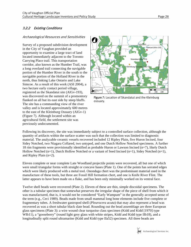
3.2.2 Existing Conditions Archaeological Resources and Sensitivities Survey of a proposed subdivision development in the City of Vaughan provided an opportunity to examine a large tract of land located immediately adjacent to the Toronto Carrying Place trail. This transportation corridor, also known as the Humber Trail, was a long overland trail connecting the navigable portion of the Humber River in the south to the navigable portion of the Holland River in the north, thus linking Lake Ontario and Lake Simcoe. As a result of this work (ASI 2004), a two hectare early contact period village, registered as the Skandatut site (AlGv-193), was discovered on the summit of a promontory flanked on all but its east side by steep bluffs. The site has a commanding view of the river valley and is located approximately 600 metres to the east of the Kleinburg Ossuary (AlGv-1) (Figure 7). Although located within an agricultural field, the settlement site was previously undocumented. Following its discovery, the site was immediately subject to a controlled surface collection, although the quantity of artifacts within the surface scatter was such that the collection was limited to diagnostic material. The analyzable ceramic vessels recovered included 12 Ripley Plain, five Huron Incised, four Sidey Notched, two Niagara Collared, two untyped, and one Dutch Hollow Notched specimens. A further 18 rim fragments were provisionally identified as probable Huron or Lawson Incised (n=7), likely Dutch Hollow Notched (n=1), Dutch Hollow Notched or a variant of Seed Incised (n=1), Sidey Notched (n=1), and Ripley Plain (n=2). Eleven complete or near complete Late Woodland projectile points were recovered, all but one of which were small triangular forms with straight or concave bases (Plate 1). One of the points has serrated edges which were likely produced with a metal tool. Onondaga chert was the predominant material used in the manufacture of these tools, but three are Fossil Hill formation chert, and one is Knife River Flint. The latter appears to have been made on a flake, and has been only minimally worked on its ventral face. Twelve shell beads were recovered (Plate 2). Eleven of these are thin, simple discoidal specimens. The other is a tubular specimen that somewhat preserves the irregular shape of the piece of shell from which it was manufactured, that is, it would not be considered “Early Wampum” in the generally accepted sense of the term (e.g., Ceci 1989). Beads made from small mammal long bone elements include five complete or fragmentary tubes. A freshwater gastropod shell (Pleurocera acuta) that may also represent a bead was recovered as was a short tubular black slate bead. Rounding out the bead assemblage are three European glass specimens (Plate 3): a wire wound clear turquoise class specimen (Kidd and Kidd [1970] type WIb11), a “gooseberry” (round light grey glass with white stripes, Kidd and Kidd type IIb18), and a longitudinally split round ultramarine (Kidd and Kidd type IIa52) specimen. All three beads are
Figure 7: Location of Skandatut and the Kleinburg ossuary.

City of Vaughan Official Plan Cultural Heritage Landscape Inventory and Policy Study Page 29
considered to date to the earliest period of European contact and exchange, circa 1580-1600 or Glass Bead Period 1 (e.g., Fitzgerald 1982; Kenyon and Kenyon 1983; Kenyon and Fitzgerald 1984; Fitzgerald et al. 1995). European trade goods in the form of metal items were recovered as well. These include eight rolled copper/brass tubes that likely served as beads, a rolled copper/brass cone or bangle, and a probable copper/brass finger ring, seven pieces of cut, folded or torn kettle scraps, the tang portion of an iron knife, and a curved iron strap or bar. An unusually large collection of ground stone tools was found on the surface of the site (Plate 4). This artifact class is dominated by 25 woodworking tools of varying sizes and in various states of preservation. Twelve specimens are complete or near complete and range from small hatchet- or gouge-sized hand tools to large heavy axes that would most likely have been hafted.
Plate 1: Sample of projectile points recovered from Skandatut.
Plate 2: Sample of shell, bone, and stone beads recovered from Skandatut

City of Vaughan Official Plan Cultural Heritage Landscape Inventory and Policy Study Page 30
The Skandatut site clearly represents a large, presumably heavily fortified, late 16th-century settlement, one that is likely associated with the nearby Kleinburg Ossuary, which was excavated in 1970 under the supervision of Dean Knight and Jerry Melbye (Plate 5). That ossuary contained the remains of 561 individuals and its structure links it to Huron/Petun ancestry. Four peripheral burials were also found including one extended, one flexed, one bundle, and one partial individual. Grave goods interred with the deposit include bone and ceramic objects, early style iron trade axes, an iron kettle, shell beads, native copper beads, and large glass trade beads. Skandatut also appears to be the latest and most northerly of the Late Iroquoian Humber River sites, representing the culmination of occupations through sites such as the early to mid-16th-century Boyd and McKenzie-Woodbridge sites and the slightly later Seed-Barker site. It may therefore represent one of the
Plate 3: Sample of glass trade beads recovered from Skandatut.
Plate 5: 1970s excavation of the Kleinburg Ossuary.
Plate 4: Sample of ground stone tools recovered from Skandatut.

City of Vaughan Official Plan Cultural Heritage Landscape Inventory and Policy Study Page 31
final moments in the permanent Iroquoian occupation of this portion of the South Slope prior to the migration of these communities northward to Huronia. On the basis of the current limited evidence, Skandatut also had external ties with the Neutral of the Hamilton-Niagara region, given the predominance of plain collarless vessels, which occur in large numbers on contact period sites in that area. It may be through such terminal Toronto area sites as Seed-Barker and Skandatut that the historically attested close relations that existed between the Petun and the Neutral were facilitated. Natural Heritage Resources and Sensitivities The terrain surrounding Skandatut consists of a rolling till plain deeply incised by the East Humber valley. The tableland has been under active cultivation to the top of the slope (Plate 6). In intensely agricultural landscapes, natural features are confined to places inaccessible to field tools (e.g., ploughs, discs, etc.) This contrasts with agriculture at the hands of First Nations where the manual nature of the work enabled access to valley slopes and bottomlands. The forest of on the valley slopes is multi-aged and composed of both deciduous and coniferous species (Plates 7 and 8). It is dominated by Sugar Maple (Acer saccharum), Red Oak (Quercus rubra), and White Ash (Fraxinus americana). Other species include American Beech (Fagus grandifolia), Ironwood (Ostrya virginia), White Pine (Pinus strobes), Eastern Hemlok (Tsuga canadensis), Black Cherry (Prunus serotina), and White Birch (Betula papyfera). Blue Beech (Carpinus caroliniana) and Bur Oak (Quercus macrocarpa) occur on the lower slopes and on the floodplain. It has few non-native invasive species. Ground cover varies considerably across the valley slope and includes Shield Fern (Dryopteris carthusiana), Wild Ginger (Asarum canadense), One-sided Aster (Aster lateriflorus), Beech Drops (Epifagus virginiana) and Virginia Waterleaf (Hydrophyllum virginiana). These give way in the moist conditions on the floodplain (Figure 4) to Ostrich Fern (Matteuccia struthiopteris), Tall Goldenrod (Solidago altissima), Herb-Robert (Geranium robertianum), Virginia Rye (Elymus virginicus) and Red Osier Dogwood (Cornus stolonifera). The multi-aged composition of the forest is a result of the succession of cultures that have occupied the site and three age and species classes have been identified that reflect possible land use. The oldest and largest trees observed include White Pine (c. 125 years),
Plate 6: Agricultural tableland.
Plate 7: Forested valley slopes.
Plate 8: Mature Eastern Hemlock.

City of Vaughan Official Plan Cultural Heritage Landscape Inventory and Policy Study Page 32
Eastern Hemlock (c. 175 years), and Sugar Maple (c. 80 to 120 years). Based on the expectation that this area was completely under corn cultivation during the occupation of Skandatut, these trees likely represent the secondary or tertiary forest that took over the slopes following the abandonment of the site by First Nations and the first wave of European occupation. The first European settlers to the Skandatut area would have found a recovering forest reflecting what seed source remained after the site was abandoned. This forest would soon be removed once more for building materials, fuel, and agricultural purposes. With the use of farm implements, European agricultural activities were more likely to be confined to the tableland, allowing the forest to recover on the slopes. This recovery phase was enhanced in the mid- to late 1800s when the significance of erosion control was understood and efforts were undertaken to deliberately restore and conserve forests. The first age class represents this recovery phase after multiple removals. The Ironwood on site, which form around 13% of the forest composition, are mostly around 40 to 60 years of age. Historical pastures tend to host unusually high numbers of Ironwood due to a combination of grazing cattle avoiding Ironwood saplings and farmers avoiding cutting them due to the extremely dense wood. It is therefore likely that cattle were pastured on the slopes and in the valley up to about 50 years ago. While avoiding Ironwood, the cattle on site would have eaten the seedlings of other tree species, likely maintaining an open canopy. Gaps in the canopy were also maintained by older and larger trees being subject to wind throw and disease. Once the cattle were removed within the last century, Sugar Maple and White Ash were free to germinate in the openings and are now reaching a density whereby self-thinning will occur due to competition for resources. The ecosystem surrounding Skandatut and the Kleinburg ossuary provided a variety of resources to Aboriginal peoples in terms of food, fuel, construction material, and medicines. The following table compiled by AECOM provides an overview of how the following species have been used by various aboriginal communities. The list is by no means exhaustive, but it emphasises the importance of plants individually and collectively to First Nations. Table 2: Overview of Ethnobotany of Plants Observed at the Site Species Services to First Nations Sugar Maple Couton (maple sap as beverage); used wood to make mortars and pestles (Huron); handles for tools;
maple sugar (Huron, Michilimackinac [sucre sauvage], Chippewa, Menomini, Meskwaki, Ojibwe, Potawatomi); sugar maple rum; inner sap boiled for sore eyes (Cherokee); arrow shafts (Ojibwa); inner bark decoction for diarrhea (Ojibwa); ingredient of remedy for gonorrhea, kidney troubles and spitting of blood (Penobscot); bowls, games, paddles (Iroquois), spoons (Chippewa); bark dried to make flour (Iroquois, Algonkian); purple dye (Chippewa); laxative, childbirth (Seneca); internal medicine (Meskwaki); vinegar (Ojibwe); deodourize traps (Potawatomi); tonic (Mohawk); astringent therefore soothing for sore eyes (Hutchens); tonic, soothing to nerves, muscle toner.
Red Oak, Bur Oak
Acorns – oil, bread (Iroquois, Kicapous, Chippewa, Menomini, Huron); construction; palisades; inner bark (Iroquois – starvation food); astringent bark (Ojibwe, Potawatomi and others), replacement for quinine; bark used for tanning; febrifuge; antiseptic, ulcers dysentery gangrene, haemorrhage, sore throat, wounds, prolapsus, poultice, spasmodic cough, asthma, chronic hysteria, amenorrhea, rheumatism, phthisis; black dye (ink); dropsy; wounds; cancer (ashes); coffee substitute; venereal diseases; antidote to poison; diarrhea (Ojibwe); liniment for horses (Mohegan); heart, lung remedy, poultice for wounds (Chippewa); expel pinworms (Meskwaki); beadwork design, brownish red dye (Potawatomi); “ruptures” (maybe haemorrhoids?) ( Mohawk);
White Ash Protection from lightning; part of remedy for smallpox (Huron); sap as beverage (Abenaki and others); venom antidote; implements (screws, wheels); bark an astringent for haemorrhages an agues; leaves for snake bite; seeds to prevent obesity; ashes diuretic; hats (Abenaki); childbirth (Penobscot); wine for treatment of fever and antiperiodic (Menomini); fish spears, snowshoes (Ojibwe); basket making (although Black Ash preferred and generally more useful); earache (Mohawk, Algonquins).
American Beech Beechnuts as food (Iroquois, Potawatomi, Huron, Ojibwe); sap as beverage (Huron); treatment for

City of Vaughan Official Plan Cultural Heritage Landscape Inventory and Policy Study Page 33
Species Services to First Nations burns; tools, brushes and many articles (e.g., bowls), fencing, building (Menomini, Potawatomi and others); fuel; potherb; inner bark and root (Menomini); treatment for poison ivy (Rappahannock)
Ironwood Ingredient for tonic for haemorrhages from the lungs, kidney trouble, rheumatism, cough syrup (Chippewa); cramp bark and cure for flux (Potawatomi)
White Pine Gum used to mend boats (Ojibwe), bark for covering wigwams (Ojibwe); curing “desparate” wounds; arrows; poultice for sores and piles; boiled root for drawing plaster; decoction of buds as purgative; cones in rheumatism and tar dissolved as wash to cure itch, tetters and wens; turpentine; leaves crushed for headache (Ojibwe); frost bite; sore throat, colds and consumption (Montagnais, Menomini, Tete de Boule, Micmac, Malecite); sores, swellings (Micmac-Montagnais); wounds, gangrene (Chippewa, Menomini, Potawatomi); inhalant (Ojibwe); staminate catkins for food (Ojibwe); haemorrhage, kidney trouble and scurvy (Micmac, Malecite)
Eastern Hemlock Cure for scurvy (Onandaga, Seneca, Meskwaki, Mohawk, Algonquin, Micmac and Malecite); part of remedy for smallpox (Huron); treatment for swellings and sores; brewing; diarrhea (Ojibwe); dye (red) (Iroquois, Ojibwe); eaten with maple sugar and corn bread (Iroquois); heal wounds, dye, beverage (Chippewa, Ojibwe); heal abdominal pains and colds, dye (Menomini, Potawatomi); remedy for pyorrhoea and stomach trouble (Meskwaki, Micmac and Malecite); fuel (Ojibwe); venereal disease (Iroquois – note that VD is a European disease); boughs liner for storage pits for corn and other vegetables, brooms (Iroquois); spice for meat (Algonquin)
Black Cherry Part of remedy for smallpox (Huron); food (Mohawk, Ojibwe, Iroquois, Chippewa, Menomini, Meskwaki, Potawatomi); bark chewed for scurvy (Illinois Miami); furniture; chewed bark applied to sores (Chippewa and others), crushed root for pains and other stomach disorders (Ojibwe); cough, tonic, diarrhea (Penobscot, Ojibwe, Potawatomi, Malecite); dysentery (Mohegan); inflammation of the bowels (Cayuga); gangrene, disinfectant, cathartic (Chippewa); blood thinner (Mohawk);
White Birch Vessels (Potawatomi, Chippewa); canoes (Huron, Abenaki, Micmac, Ojibwe, Tete de Boule); beverage (Huron, Iroquois, Chippewa); torches (Huron, Chippewa, Ojibwe); shelter (Huron); coffin (Huron); seed storage (Huron); cathartic (Huron); art and communication (Chippewa, Ojibwe); beds; consumption remedy (Ojibwe); dusting powder (Cree); tool to remedy cataract (Dene); food (Montagnais); enema (Chippewa); flavour for medicine (Ojibwe, Potawatomi); carminative (Seneca); stomach remedy (Ojibwe); roofing for wigwams (Ojibwe); dye (Ojibwe); rheumatism and hydropsy; headache (Ojibwe)
Shield Fern, Ostrich Fern
There is some confusion over which species were used but services appear to include treatments for rickets, worms, pulmonary and liver disease and use as a purgative.
Wild Ginger Remedy for pains of childbirth (Illinois Miami); snuff for disorders of the eyes and head; diaphoretic or sweating tea; spice (Meskwaki, Ojibwe, Potawatomi and others); appetizer (Chippewa); poultice for fractures (Chippewa); remedy for weak stomach (Menomini, Meskwaki); earache, cramps (Meskwaki); coughs, carminative (Seneca); Protection from witchcraft (Ojibwe); reduce fever in typhoid, asthma (Rappahannock, Mohawk); contraceptive;
One-sided Aster Additive to sweat bath, cure for crazy person (Meskwaki) Virginia Waterleaf
Leaves cooked like spinach (Iroquois, Menomini); astringent (Menomini); treatment for flux (Ojibwe, Meskwaki)
Tall Goldenrod Tea (Potawatomi and others); fevers (Cherokee, Chippewa, Potawatomi); tonic (Cree); poultice for boils, ulcers (Chippewa); treatment for burns (Chippewa); pains in the side (Mohawk); yellow dye
Red Osier Dogwood
Additive to tobacco (Chippewa, Cree, Menomini and others); tea, cough, cold and fever remedy, black dye (Cree); sore eye remedy, dye (Chippewa); kinnikinnik (Chippewa, Menomini); enema (Menomini, Ojibwe); treatment for diarrhea and flux (Potawatomi, Ojibwe, Chippewa); dyspepsia (Mohawk); sore eyes and throat, catarrh and headache treatment (Malecite); poison ivy (Chippewa)
3.2.3 Potential Cultural Heritage Significance
The Skandatut site (AlGv-193) and Kleinburg Ossuary (AlGv-1), combined with the surrounding natural setting and landscape features, together serve as an excellent example of an associative cultural heritage landscape within the City of Vaughan. Within its boundaries, cultural material dating to the late sixteenth century survives. Archaeological excavations uncovered a late Iroquoian village and a large ossuary within this area. These two sites are associated and are linked to Huron/Petun ancestry. Together they express sacred traditions and settlement patterns associated with the Huron/Petun and also reflect upon
City of Vaughan Official Plan Cultural Heritage Landscape Inventory and Policy Study Page 34
the final moments of the permanent Iroquoian occupation in this portion of the South Slope prior to the migration of these communities northward to Huronia. Although portions of these archaeological sites have been investigated, the village remains largely intact. The area’s natural topography has also remained remarkably intact and retains several above ground features that recall late sixteenth century settlement and subsistence patterns as well as more recent land use activities dating to the nineteenth and early twentieth century. Generally, the topography of the study area has not been substantially altered and can be characterized by its expanse of rolling tablelands and steep valley slopes. The tablelands continue to exhibit active cultivation; a landscape process that has likely dominated these lands since the late sixteenth century. The area also continues to retain steep valley slopes leading down from the tablelands to the tributary of the East Humber River. The retention of these features and the spatial relationship between the tributary, tablelands, valley slopes and bottomlands, and below grade resources express late sixteenth century, and later nineteenth and early twentieth century defensive systems, subsistence patterns, resource needs, and circulations routes. It is quite likely that the elevation of the Skandatut site would have provided an important defensive position with commanding views over the adjacent landscape and would have also provided important views between the village site and adjacent burial grounds to the west. The area’s retention of forests on the valley slopes and vegetative ground cover also evidences Aboriginal land uses and occupation in the subject area as well as nineteenth and early twentieth century land uses associated with township development activities. The valley slopes retain native tree species including Sugar Maple, Red Oak, White Ash, American Beech, Ironwood, White Pine, Eastern Hemlock, Black Cherry, and White Birch, while ground cover across the valley slope includes Shield Fern, Wild Ginger, One-sided Aster, Beech Drops, and Virginia Waterleaf. With respect to the tree cover along the valley slope, Sugar Maple, White Pine and Eastern Hemlock represent the largest and oldest tree species. It is highly likely that these tree species, which range in age, with the oldest dating to ca. 1835, represent regenerative forest growth that followed abandonment of the site in the late sixteenth century. The first European settlers to the area would have arrived in the early nineteenth century and would have cleared this regenerative forest to establish farmsteads and commence agricultural production. These tree species, which date to the nineteenth century evidence the natural processes that reclaimed the landscape following abandonment of late Iroquoian village site and also evidence human interventions with the natural landscape that transpired throughout the nineteenth century. Additionally, retention of Ironwood trees, which form 13% of the forest composition, evidence more recent agricultural land use activities that date to the mid-twentieth century. Overall, retention of native forest growth and vegetative ground cover directly evidences nineteenth century land use activities associated with agricultural production and early settlement and indirectly expresses past Aboriginal occupation of the site, as many of the currently extant tress and ground cover would have provided a variety of resources to Aboriginal inhabitants of the Skandatut site in terms of food, fuel, construction, material, and medicines. The following provides a preliminary identification of the site’s heritage attributes
• Active cultivation of tablelands located east of the tributary of the East Humber River • Tributary of East Humber River • Steep valley slopes located on either side of the tributary • Below-grade archaeological resources • Forest cover on valley slopes and bottomlands consisting of Sugar Maple, Red Oak, White Ash,
American, Beech, Ironwood, White Pine, Eastern Hemlock, Black Cherry, White Birch, Blue Beech, and Bur Oak.
• Vegetative ground cover along the valley slope including Shield Fern, Wild Ginger, One-Sided Aster, Beech Drops, and Virginia Waterleaf.

City of Vaughan Official Plan Cultural Heritage Landscape Inventory and Policy Study Page 35
• Vegetative ground cover within the floodplain which include: Ostrich Fern, Tall Goldenrod, Herb-Robert, Virginia Rye, and Red Osier Dogwood.
• Natural elevation of the Skandatut site and Kleinburg Ossuary in relation to adjacent valley lands.