hirloc: high-resolution robust localization for wireless ...llazos/papers/lazos_jsac05.pdf ·...
TRANSCRIPT
HiRLoc: High-resolution Robust Localization forWireless Sensor Networks
Loukas Lazos and Radha PoovendranNetwork Security Lab, Dept. of EE,
University of Washington, Seattle, WA 98195-2500{l lazos, radha }@ee.washington.edu
Abstract— In this paper we address the problem of robustlyestimating the position of randomly deployed nodes of a WirelessSensor Network (WSN), in the presence of security threats.We propose a range-independent localization algorithm calledHiRLoc, that allows sensors to passively determine their locationwith high resolution, without increasing the number of referencepoints, or the complexity of the hardware of each referencepoint. In HiRLoc, sensors determine their location based onthe intersection of the areas covered by the beacons transmittedby multiple reference points. By combining the communicationrange constraints imposed by the physical medium with computa-tionally efficient cryptographic primitives that secure the beacontransmissions, we show that HiRLoc is robust against knownattacks on WSN, such as the wormhole attack, the Sybil attackand compromise of network entities. Finally, our performanceevaluation shows that HiRLoc leads to a significant improvementin localization accuracy compared to state-of-the-art range-independent localization schemes, while requiring fewer referencepoints.
Index Terms— Algorithm, Design, Performance, Security
I. I NTRODUCTION
When wireless sensor networks (WSN) are deployed tomonitor and record a wide range of valuable information, suchas acoustic, visual, thermal, seismic, or any other type of mea-sured observation, it is essential that sensor reports are coupledwith the location that the observation occurred. Since futureapplications of WSN envision on-demand network deploymentin a self-configurable way with no pre-specified structure orsupporting infrastructure, sensors cannot know their locationapriori. Hence, sensors need to apply a localization process inorder to discover their location. This localization process mustoccur during the network initialization and when the locationof the sensor changes, or, alternatively, can be applied ondemand when localization information is required by networkprotocols such as, routing and security protocols [2], [12], [17].
Since sensors are intended to be low-cost disposable de-vices, currently developed solutions such as GPS [11], areinadequate for the hardware and power-limited sensors. Fur-thermore, since WSN may be deployed in hostile environmentsand operate in an untethered manner, they are susceptible toa variety of attacks [9], [12], [14] that could significantlyimpact the accuracy of the localization process. Since locationinformation is an integral part of most wireless sensor networkservices such as geographical routing [2], and applicationssuch as target tracking and monitoring, it is of paramountimportance to secure the localization process. While the topicof sensor localization in a trusted environment has been
extensively studied in the literature, [1], [5], [10], [25], [26],[30], [31], localization in the presence of malicious adversariesremains an unexplored area of research [6], [15], [18]–[22].
In this paper we address the problem ofenabling nodes ofa WSN to compute a high-resolution estimate of their locationeven in the presence of malicious adversaries.This problemwill be referred to asHigh Resolution Secure Localization.Since sensors are limited in hardware capabilities we pursuesolutions that do not require any special ranging hardwareat the sensor side to infer quantities such as range or angleof arrival estimates. We refer to those solutions as range-independent. Specifically, we consider secure localization forwireless sensor networks in the context of, (a) decentralizedand scalable implementation, (b) resource efficiency in com-putation, communication and storage, (c) range-independence,and (d) robustness against security threats in WSN.
In this paper we make the following contributions. Weintroduce a novel localization scheme for WSN called High-resolution Range-independent Localization (HiRLoc), that al-lows sensors to passively determine their location with highaccuracy (sensors do not interact to determine their loca-tion). The increased localization accuracy is the result ofcombination of multiple localization information over a shorttime period, and does not come at the expense of increasedhardware complexity or deployment of reference points withhigher density. Since our method does not perform anyrange measurements to estimate the sensors’ location, it isnot susceptible to any range measurement alteration attacks.Furthermore, sensors do not rely on other sensors to infertheir location and hence, the robustness of our localizationmethod does not rely on the easily tampered sensor devices.Finally, we show that our method is robust against well knownsecurity threats in WSN, such as the wormhole attack [12],[28], the Sybil attack [9], [13], [33], and compromise ofnetwork entities. Based on our performance evaluation, weshow that HiRLoc localizes sensors with higher resolution thanpreviously proposed decentralized range-independent localiza-tion schemes [3], [10], [18], [25], [26], while requiring fewerhardware resources.
The remainder of the paper is organized as follows: InSection II we state our network model assumptions. SectionIII describes HiRLoc and Section IV presents the securityanalysis. In Section V, we provide the performance evaluation.In Section VI we review related work and in Section VII wepresent open problems and discussion. Section VIII presentsour conclusions.
2
II. N ETWORK MODEL ASSUMPTIONS
Network deployment: We assume that a set of sensorsSwith unknown locationis randomly deployed with a densityρs within an areaA. We also assume that a set of speciallyequipped nodes withknown location1 and orientation, calledlocators are also randomly deployed with a densityρL, withρs À ρL.
The random deployment of the locators with a densityρL
can be modeled after ahomogeneous Poisson point processofrateρL [8]. The random deployment of sensors with a densityρs, can be modeled after a random sampling of the areaAwith rateρs [8]. If LHs denotes the set of locators heard by asensors, i.e. being within rangeR from s, the probability thats hears exactlyk locators, is given by the Poisson distribution[8]:
P (|LHs| = k) =(ρLπR2)k
k!e−ρLπR2
. (1)
Note that (1) provides the probability that a randomlychosen sensor hearsk locators given that locators arerandomly distributed and not Poisson distributed [8].
Antenna model: We assume that sensors are equipped withomnidirectional antennas, able to transmit with maximumpower Ps, while locators are equipped withM directionalantennas with a directivity gainG > 1, and can simultaneouslytransmit on each antenna with maximum powerPL > Ps.
2 Wealso assume that locators can vary their transmission rangefrom zero to a maximum value ofR, via power control.Furthermore, we assume that locators can change their antennadirection, either through changing their orientation or rotatingtheir directional antennas.
III. H IRLOC: HIGH-RESOLUTIONRANGE-INDEPENDENT
LOCALIZATION SCHEME
In this section we present the High-resolution Range-independent Localization scheme (HiRLoc) that allows sensorsto determine their location with high accuracy even in thepresence of security threats. HiRLoc achieves passive sensorlocalization based on beacon information transmitted fromthe locators with improved resolution compared to our initialalgorithm (SeRLoc) presented in [18], [19], at the expense ofincreased computational complexity and communication.
A. Location Determination
In order to determine their location, sensors rely on beaconinformation transmitted from the locators. Each locator trans-mits a beacon at each directional antenna that contains, (a)
1Position can be acquired through manual insertion or through GPSreceivers [11]. Though GPS signals can be spoofed, knowledge of thecoordinates of several nodes is essential to generate a coordinate referencesystem. An effort to secure GPS localization has been recently proposed in[15].
2The higher transmission power at the locators is a reasonable assumption,given that sensors are low-power devices. A typical sensor has a maximumtransmission power ofPs = 0.75mW [24]. For a homogeneous mediumwith attenuation factorγ = 2 locators need to transmit with a powerPg =75mW to achieve a communication range ratioR
r= 10, without taking into
consideration the directivity gain of the locators’ antennas.
the locator’s coordinates, (b) the angles of the sector boundarylines defined by the directional transmission, with respect toa common global axis and, (c) the locator’s communicationrangeR. Locators may change their orientation over time andretransmit beacons in order to improve the accuracy of thelocation estimate. Based on the beacon information, sensorsdefine the sector areaSi(j) as the confined area covered bythe jth transmission of a locatorLi.
A sensor s receiving thejth beacon transmission fromlocatorLi, is included within the sector areaSi(j). Note thatsensors do not perform any signal strength, time of flight, orangle of arrival measurement and hence, HiRLoc is a range-independent localization scheme. LetLHs(j) denote the setof locators heard by a sensors, during thejth transmissionround. By collecting beacons from the locatorsLi ∈ LHs(j),the sensor can compute its location (an area rather than asingle point), as theRegion of Intersection(ROI) of all thesectorsSi(j). Note that a sensor can hear beacons frommultiple locators, or multiple beacons generated by the samelocator. Hence, theROI after the mth round of beacontransmissions can be expressed as the intersection of all thesectors corresponding to the beacons available at each sensor:
ROI(m) =m⋂
j=0
|LHs(j)|⋂
i=1
Si(j)
. (2)
Since theROI indicates the confined region where thesensor is located, reducing the size of theROI leads to anincrease in the localization accuracy. Based on equation (2),we can reduce the size of theROI by, (a) reducing the sizeof the sector areasSi(j) and, (b) increase the number ofintersecting sectorsSi(j).
In our previous algorithm named SeRLoc [18], [19], sen-sors compute their location by collecting only one beacontransmission from each locator. Since subsequent rounds oftransmissions contain identical sector information as the firstround of transmissions, the reduction of theROI in SeRLoccan only be achieved by, (a) increasing the locator densityρL so that more locators are heard at each sensor, and highernumber of sectors intersect or, (b) by using narrower antennasectors to reduce the size of the sectorsSi(j). Both thesemethods reduce the localization error at the expense of highernumber of devices with special capabilities (more locators),and more complex hardware at each locator (more antennasectors).
In HiRLoc, we propose methods for reducing theROI byexploiting the temporal dimension, and without incurring thecosts of deploying more locators, or equipping them withexpensive antenna systems. The locators provide differentlocalization information at consecutive beacon transmissionsby, (a) varying the direction of their antennas and, (b) varyingthe communication range of the transmission via powercontrol. We now explore how both these methods lead to thereduction of theROI.
1. Varying the antenna orientation: The locators are capableof transmitting at all directions (omnidirectional coverage)using multiple directional antennas. Every antenna has a
3
(a) (b) (c)
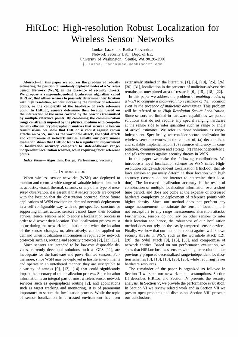
Fig. 1. (a) The sensor is located within the intersection of the sectorsS1(j), S2(j), which defines the region of intersectionROI. (b) TheROI is reducedby the rotation of the antenna sectors by some angleα. (c) LocatorL1 is equipped with three directional antennas of beamwidth2π
3each. The transmission
of beacons at each sector, followed by antenna rotation byπ3
, followed by a transmission of update beacons, is equivalent to equippingL1 with six directionalantennas of beamwidthπ
3.
specific orientation and hence corresponds to a fixed sectorareaSi(j). The antenna orientation is expressed by the angleinformation contained in the beaconθi(j) = {θi,1(j), θi,2(j)},whereθi,1(j), θi,2(j) denote the lower and upper bounds ofthe sectorSi(j).
Instead of reducing the size of the intersecting sectors bynarrowing the antenna beamwidth, locators can change theorientation of their antennas and re-transmit beacons with thenew sector boundaries. A change in the antenna orientation canoccur either by changing the orientation of the locators, or byrotation of their antenna system. A sensor collects multiplesector information from each locator over a sequence oftransmissions:Si(j) = Si(θi(j), j), j = 1 . . . Q. As expressedby equation (2), the intersection of a larger number of sectorscan lead to a reduction in the size of theROI. As an example,consider figure 1 where a sensors hears locatorsL1, L2. Infigure 1(a), we show the first round of beacon transmissionsby the locatorsL1, L2, and the correspondingROI(1). Infigure 1(b), the locatorsL1, L2 rotate their antennas by anangleα and transmit the second round of beacons with thenew sector boundaries.TheROI in the two rounds of beacontransmissions, can be expressed as:
ROI(1) = S1(1) ∩ S2(1),ROI(2) = S1(1) ∩ S1(2) ∩ S2(1) ∩ S2(2). (3)
The antenna rotation can be interpreted as an increaseon the number of antenna sectors of each locator viasuperposition over time. For example, consider figure 1(c),where a locator is equipped with three directional antennasof beamwidth 2π
3 . Transmission of one round of beacons,followed by antenna rotation byπ3 and re-transmission ofthe updated beacons is equivalent to transmitting one roundof beacons when locators are equipped with six directionalantennas of beamwidthπ3 .
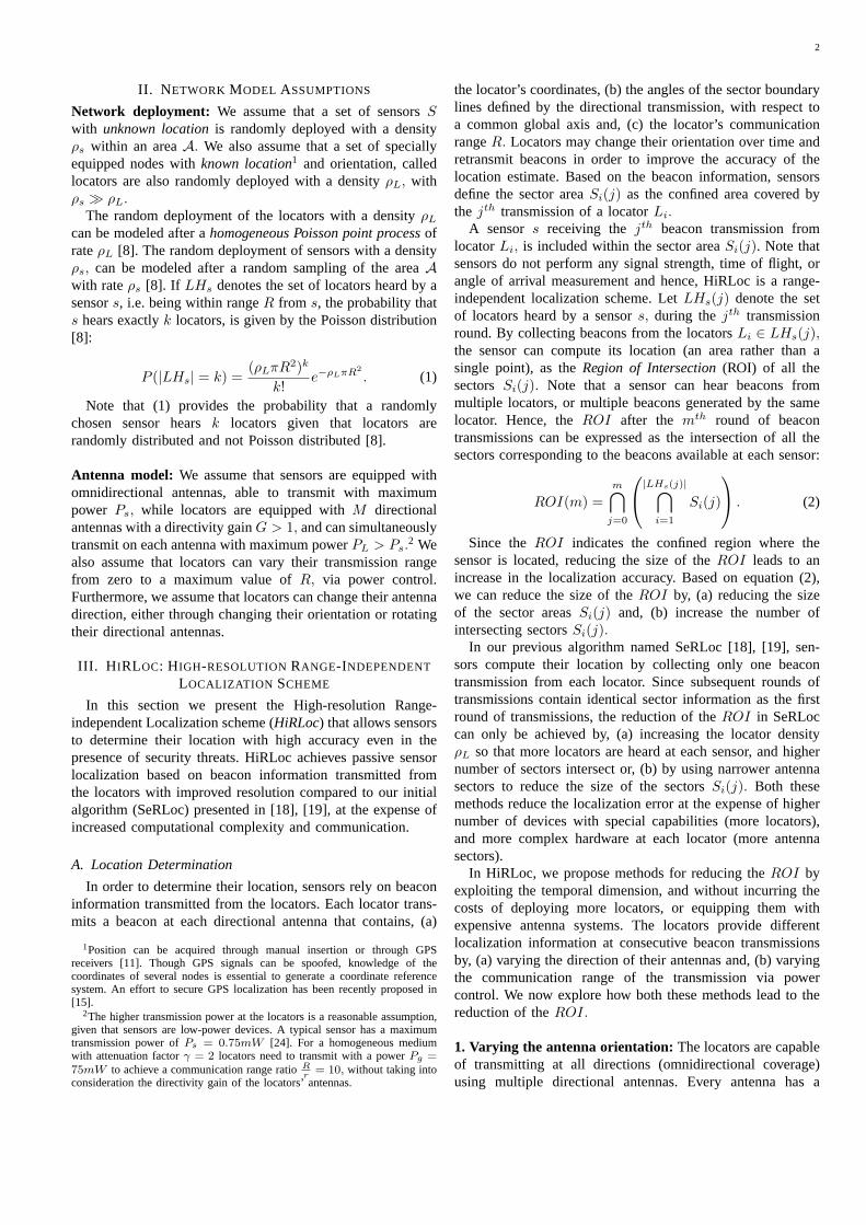
2. Varying the Communication range: A second approachto reduce the area of theROI, is to reduce the sizeof the intersecting sectors. This can be achieved byallowing locators to decrease their transmission powerand re-broadcast beacons with the new communicationrange information. In such a case, the sector areaSi(j)
is dependent upon the communication rangeRi(j) at thejth transmission, i.e.Si(j) = Si(R(j), j). To illustratethe ROI reduction, consider figure 2(a), where locatorsL1, L2 transmit with their maximum power; sensorscomputes:ROI(1) = S1(1) ∩ S2(1). In figure 2(b), locatorsL1, L2 reduce their communication range by lowering theirtransmission power and re-transmit the updated beacons.While locator L1 is out of range from sensors and,hence, does not further refine the sensor’s location,s canstill hear locatorL2 and therefore, reduce the size of theROI.
3. Hybrid approach: The combination of the variation ofthe antenna orientation and communication range leads to adual dependency of the sector areaSi(θi(j), R(j), j). Such adependency can also be interpreted as a limited mobility modelfor the locators. For a locatorLi moving in a confined area, theantenna orientation and communication range with respect toa static sensor varies, thus providing the sensor with multiplesector areasSi(j). The mobility model is characterized aslimited, since the locator has to be within the range of thesensor for at least a fraction of its transmissions in orderto provide the necessary localization information. We nowpresent the algorithmic details of HiRLoc.
B. The algorithmic details of HiRLoc
Equation (2), expresses two different ways of computingthe region of intersection. We can, (a) collect all beacons overseveral transmission rounds and compute the intersection ofthe all sector areas or, (b) estimateROI after every roundof transmissions and intersect it with the previous estimateof the ROI. We will refer to the first approach as HiRLoc-Iand the latter approach as HiRLoc-II. Though both of theseapproaches result in the same estimate of theROI, theyexhibit different properties explained below.
HiRLoc-I: Computing the intersection of all sector areas
In the first version of HiRLoc the estimation of theROI iscomputed by collecting all beacons transmitted by each locatorover time, intersecting all sectors of each locator and thenintersecting the outcome.
4
(a) (b) (c)
Fig. 2. (a) The sensor is located within the intersection of the sectorsS1(j), S2(j), which defines theROI, (b) the locators reduce their communicationrange and transmit updated beacons. Whiles is outside the communication range ofL1, it can still hear the transmission ofL2. The new beacon informationleads to the reduction of theROI. (c) The intersection of multiple sectors originating from the same locator with the same angle boundaries but differenttransmission rangeRi(j) is equal to the sector with the smallest communication range.
ROI(m) =⋂
|LHs|
m⋂
j=0
Si(j)
(4)
The algorithmic steps performed are:
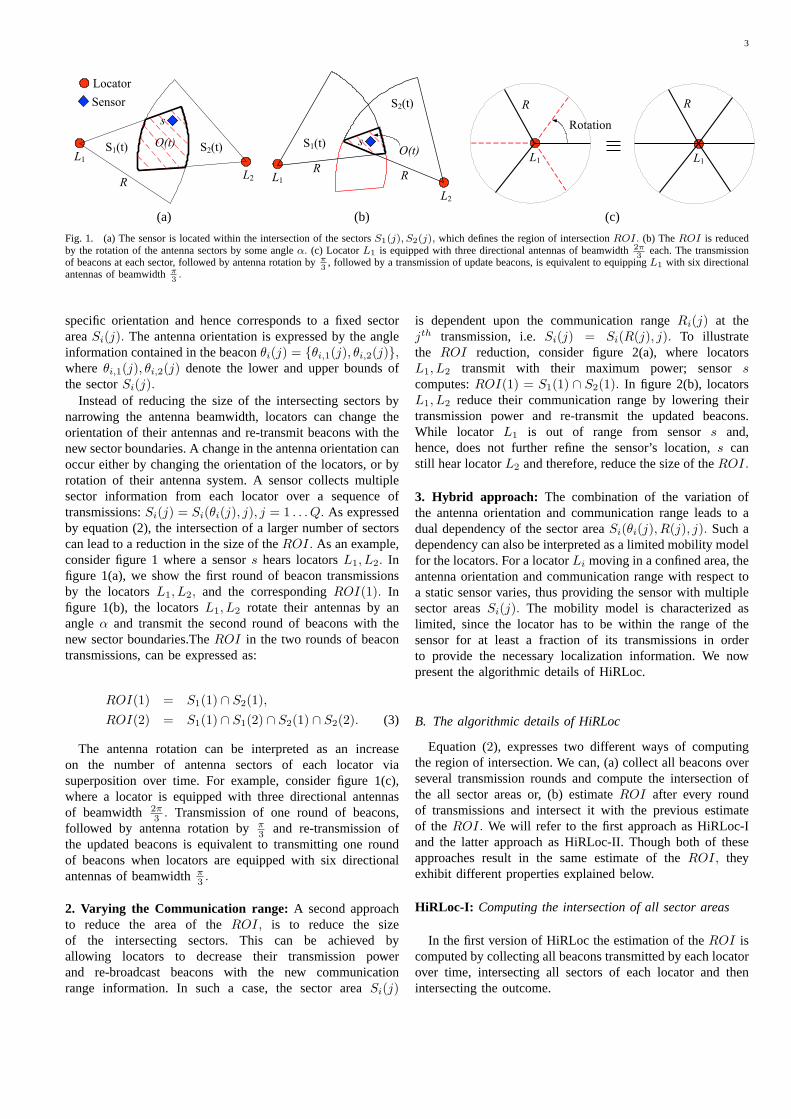
Step 1:Initial estimate of the ROI—In step 1, the sensordetermines the set of locatorsLHs that will be used for itslocalization. Based on the coordinates of the locatorsLi ∈LHs, and the maximum communication range of the locators,denoted asRmax, the sensor calculates the first estimate oftheROI as follows: LetXmin, Ymin, Xmax, Ymax denote theminimum and maximum locator coordinates form the setLHs
defined as:
Xmin = minLi∈LHs
Xi, Xmax = maxLi∈LHs
Xi,
Ymin = minLi∈LHs
Yi, Ymax = maxLi∈LHs
Yi. (5)
Since every locator in setLHs is within a rangeRmax
from sensors, if s can hear locatorLi with coordinates(Xmin, Yi), it has to be locatedleft from the vertical boundaryof (Xmin + R). Similarly, s has to be locatedright fromthe vertical boundary of (Xmax − R), below the horizontalboundary of (Ymin + R), andabovethe horizontal boundaryof (Ymax −R).
Step 2: Beacon collection—In step 2, sensors continueto collect all the beacons heard over multiple beacontransmission rounds3, generated due to changes in theparameters of the antenna sector. We describe three differentoptions on the type of parameter changes that the locatorscan perform.
Option A: Antenna orientation variation —The locatorsrotate their antennas by a pre-specified angleα = 2π
QM ,where M is the number of antenna sectors at each locatorand (Q − 1) is the total number of antenna rotations untilthe initial configuration is repeated (A total ofQ different
3The jth transmission round is defined as the time until every locatorLi ∈ LHs has completed itsjth beacon transmission.
transmissions take place). The antenna orientation variationincreases the number of sectors defining theROI by a factorof (Q− 1). The number of intersecting sectorSi(j) is equalto Q|LHs|. Hence, the algorithmic complexity for computingthe ROI is increased by a factor of(Q − 1) compared toSeRLoc [18].
Option B: Communication range variation—The locatorsreduce their communication range by a pre-specified amountat each transmission round. IfN is the total number of distinctcommunication ranges, the locators reduce the range byRmax
N ,at each round.
Note that not all beacons from the same locator provideuseful information for the determination of theROI. As anexample, consider figure 2(c) where the locatorL1 graduallyreduces its transmission range fromRmax to (N−k)Rmax
N .Since∩k
j=1Si(j) = Si(k), if a sensor is able to hear thekth
transmission ofL1, only the sector area corresponding toSi(k) contributes to the estimation of theROI. Hence, allprevious beacons can be ignored. The communication rangevariation does not increase the number intersecting areas andhence does not increase the algorithmic complexity comparedto SeRLoc [18]. The number of sector areas that intersect todefine theROI is equal to|LHs|.
Option C: Combination of options A, B—Locators canvariate both their communication range and their antennaorientation, by going through a total of(Q− 1)(N − 1) steps.The number of sectorsSi(j) that intersect to define theROIis (Q − 1)|LHs|, and the algorithmic complexity is equal tooption A.
Step 3: Determination of the ROI—Though analyticalcomputation of theROI is achievable based on the intersec-tion of the boundary lines of the sectors, in order to reduce thecomputational complexity, each sensor uses a majority vote-based scheme as in SeRLoc [18], and described briefly here.The sensor places a grid of equally spaced points within thefirst estimate of theROI computed in Step 1. For each gridpoint, the sensor holds a score in a Grid Score Table (GST),with initial scores set to zero. Letgi denote theith grid point.
5
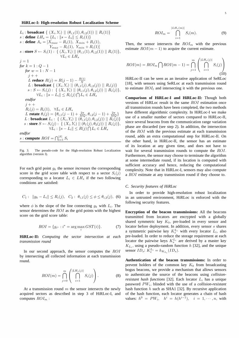
HiRLoc-I: High-resolution Robust Localization Scheme
Li : broadcast { (Xi, Yi) || (θi,1(1), θi,2(1)) || Ri(1)}s : define LHs = {Li : ‖s− Li‖ ≤ Ri(1)}s : define As = [Xmax −Ri(1), Xmin + Ri(1),
Ymax −Ri(1), Ymin + Ri(1)]s : storeS ← Si(1) : { (Xi, Yi) || (θi,1(1), θi,2(1)) || Ri(1)},
∀Li ∈ LHs
j = 1for k = 1 : Q− 1
for w = 1 : N − 1j + +L reduce R(j) = R(j − 1)− R(1)
NL : broadcast { (Xi, Yi) || (θi,1(j), θi,2(j)) || Ri(j)}s : S ← Si(j) : { (Xi, Yi) || (θi,1(j), θi,2(j)) || Ri(j)},
∀Li : ‖s− Li‖ ≤ Ri(j)⋂
Li ∈ LHs
endforj + +Ri(j) = Ri(1), ∀Li ∈ LHs
L rotate θi(j) = {θi,1(j − 1) + 2πMQ , θi,2(j − 1) + 2π
MQ}L : broadcastLi : { (Xi, Yi) || (θi,1(j), θi,2(j)) || Ri(j)}s : store S ← Si(j) : { (Xi, Yi) || (θ1(j), θ2(j)) || Ri(j)},
∀Li : ‖s− Li‖ ≤ R(j)⋂
Li ∈ LHs
endfors : compute ROI =
⋂|S|i=1 Si
Fig. 3. The pseudo-code for the High-resolution Robust Localizationalgorithm (version I).
For each grid pointgk the sensorincreasesthe correspondingscore in the grid score table with respect to a sectorSi(j)corresponding to a locatorLi ∈ LHs if the two followingconditions are satisfied:
C1 : ‖gk − Li‖ ≤ Ri(j), C2 : θi,1(j) ≤ φ ≤ θi,2(j), (6)
whereφ is the slope of the line connectinggk with Li. Thesensor determines theROI as the grid points with the highestscore on the grid score table:
ROI = {gi∗ : i∗ = arg maxi
GST (i)}. (7)
HiRLoc-II: Computing the sector intersection at eachtransmission round
In our second approach, the sensor computes theROIby intersecting all collected information at each transmissionround.
ROI(m) =m⋂
j=0
|LHs(j)|⋂
i=1
Si(j)
. (8)
At a transmission roundm the sensor intersects the newlyacquired sectors as described in step 3 of HiRLoc-I, andcomputesROIm :
ROIm =|LHs(m)|⋂
i=1
Si(m). (9)
Then, the sensor intersects theROIm with the previousestimateROI(m− 1) to acquire the current estimate.
ROI(m) = ROIm
⋂ROI(m− 1) =
m⋂
j=1
|LHs(j)|⋂
i=1
Si(j)
(10)HiRLoc-II can be seen as an iterative application of SeRLoc[18], with sensors using SeRLoc at each transmission roundto estimateROIt and intersecting it with the previous one.
Comparison of HiRLoc-I and HiRLoc-II: Though bothversions of HiRLoc result in the sameROI estimation onceall transmission rounds have been completed, the two methodshave different algorithmic complexity. In HiRLoc-I we makeuse of a smaller number of sectors compared to HiRLoc-II,since several beacons from the communication range variationphase are discarded (see step 2). In addition, the intersectionof the ROI with the previous estimate at each transmissionround, adds an extra computational step for HiRLoc-II. Onthe other hand, in HiRLoc-II, the sensor has an estimateof its location at any given time, and does not have towait for several transmission rounds to compute theROI.Furthermore, the sensor may choose to terminate the algorithmat some intermediate round, if its location is computed withsufficient accuracy and hence, reducing the computationalcomplexity. Note that in HiRLoc-I, sensors may also computea ROI estimate at any transmission round if they choose to.
C. Security features of HiRLoc
In order to provide high-resolution robust localizationin an untrusted environment, HiRLoc is enforced with thefollowing security features.
Encryption of the beacon transmissions:All the beaconstransmitted from locators are encrypted with a globallyshared symmetric keyK0, pre-loaded in every sensor andlocator before deployment. In addition, every sensors sharesa symmetric pairwise keyKLi
s with every locatorLi, alsopre-loaded. In order to reduce the storage requirement at eachlocator the pairwise keysKLi
s are derived by a master keyKLi , using a pseudo-random functionh [32], and the uniquesensorIDs: KLi
s = hKLi(IDs).
Authentication of the beacon transmissions:In order toprevent holders of the common keyK0 from broadcastingbogus beacons, we provide a mechanism that allows sensorsto authenticate the source of the beacons usingcollision-resistant hash functions[32]. Each locatorLi has a uniquepasswordPWi, blinded with the use of acollision-resistanthash functionh such as SHA1 [32]. By recursive applicationof the hash function, each locator generates a chain of hashvalues:h0 = PWi, hi = h(hi−1), i = 1, · · · , n, with
6
h0 never revealed to any sensor. The numbern of hashvalues stored at each locator determines the number of beacontransmissions that each locator can perform and hence, hasto be large. Due to the collision resistance property, it iscomputationally infeasible for any attacker to find aPWj ,such thath(PWi) = h(PWj), PWi 6= PWj .
To enable sensors to authenticate a beacon transmission,each sensor is pre-loaded with a table containing theIDLi
of each locator and the corresponding hash valuehn(PWi).To reduce the locator storage requirements, locators employan efficient storage/computation method for hash chains oftime/storage complexityO(log2(n)) [7].
Authentication mechanism:A locator transmitting itsjth
beacon appends the next hash valuehn−j(PWi) towards thebeginning of the hash chainh(PWi), along with the indexj. Every sensor that hears the beacon, hashes the receivedhash value to verify thath(hn−j(PWi)) = hn−j+1(PWi).If the verification is correct, the sensor accepts the beaconinformation, replaceshn−j+1(PWi) with hn−j(PWi) in itsmemory, and increases the hash counter by one. The hashcounter facilitates the synchronization with the latest publishedhash value, in case of loss of some intermediate hash values.The jth beacon format of locatorLi is as follows:
Li : { loci || (hn−j(PWi)) ‖ j ‖ IDLi }K0 ,
whereloci = (Xi, Yi) || (θi,1(j), θi,2(j)) || Ri(j), || denotesthe concatenation operation and{m}K denotes the encryptionof messagem with key K. Note that our authenticationmechanism does not prevent a sensor from authenticating abogus beacon, if the beacon originates from a locator that isnot within the communication range of the sensor. However,our method guarantees that beacons originating from the setof locators directly heard by a sensors, are indeed authentic.In our threat analysis we will show that this is a sufficientcondition for the robust location computation when sensorsare under attack.
IV. SECURITY THREATS AGAINSTHIRLOC
In this section, we explore the security threats againstHiRLoc, that can occur when sensors are deployed in anuntrusted environment. We show that HiRLoc allows sensorsto perform robust high-resolution location computation evenin the presence of malicious adversaries.
A. Attacker model
We assume that the goal of the attacker, is to displace thesensor, i.e. lead the sensor to a location estimation significantlydifferent than its actual location. Furthermore, we assumethat the adversary attacking the localization scheme wants toremain undetected by the sensors, or the locators. Hence, wedo not consider all possible denial-of-service attacks (DoS)attacks that will prevent the sensor from any location com-putation.Note that our defense mechanisms are developed toallow the robust location computation even in the presenceof malicious adversaries, and not to prevent the attacks frominterrupting other network protocols.
B. The Wormhole Attack
Threat model: In the wormhole attack discussed in [12],[28], an adversary deploys a direct link referred aswormholelink between two points on the network with a distancelonger than the communication range. The adversary recordsany broadcasted information at one end of the wormholelink, known as theorigin point, tunnels it to the other endof the link, known asdestination point, and replays theinformation into the network. Hence, the wormhole attack canbe launched without compromising any host, or the integrityand authenticity of the communication and is difficult todetect [12].
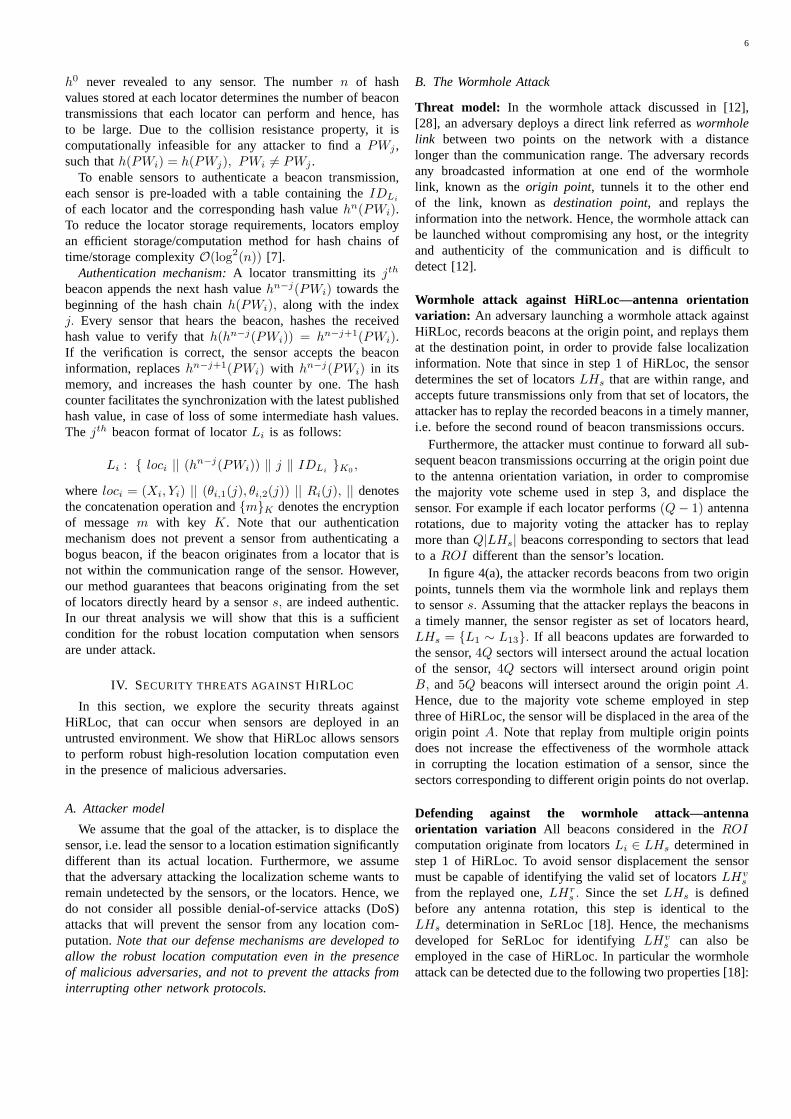
Wormhole attack against HiRLoc—antenna orientationvariation: An adversary launching a wormhole attack againstHiRLoc, records beacons at the origin point, and replays themat the destination point, in order to provide false localizationinformation. Note that since in step 1 of HiRLoc, the sensordetermines the set of locatorsLHs that are within range, andaccepts future transmissions only from that set of locators, theattacker has to replay the recorded beacons in a timely manner,i.e. before the second round of beacon transmissions occurs.
Furthermore, the attacker must continue to forward all sub-sequent beacon transmissions occurring at the origin point dueto the antenna orientation variation, in order to compromisethe majority vote scheme used in step 3, and displace thesensor. For example if each locator performs(Q− 1) antennarotations, due to majority voting the attacker has to replaymore thanQ|LHs| beacons corresponding to sectors that leadto a ROI different than the sensor’s location.
In figure 4(a), the attacker records beacons from two originpoints, tunnels them via the wormhole link and replays themto sensors. Assuming that the attacker replays the beacons ina timely manner, the sensor register as set of locators heard,LHs = {L1 ∼ L13}. If all beacons updates are forwarded tothe sensor,4Q sectors will intersect around the actual locationof the sensor,4Q sectors will intersect around origin pointB, and5Q beacons will intersect around the origin pointA.Hence, due to the majority vote scheme employed in stepthree of HiRLoc, the sensor will be displaced in the area of theorigin point A. Note that replay from multiple origin pointsdoes not increase the effectiveness of the wormhole attackin corrupting the location estimation of a sensor, since thesectors corresponding to different origin points do not overlap.
Defending against the wormhole attack—antennaorientation variation All beacons considered in theROIcomputation originate from locatorsLi ∈ LHs determined instep 1 of HiRLoc. To avoid sensor displacement the sensormust be capable of identifying the valid set of locatorsLHv
s
from the replayed one,LHrs . Since the setLHs is defined
before any antenna rotation, this step is identical to theLHs determination in SeRLoc [18]. Hence, the mechanismsdeveloped for SeRLoc for identifyingLHv
s can also beemployed in the case of HiRLoc. In particular the wormholeattack can be detected due to the following two properties [18]:
7
(a) (b)
Fig. 4. (a) Wormhole attack—antenna orientation variation: an attacker records beacons in areaB, tunnels them via the wormhole link in areaA andre-broadcasts them. (b) Wormhole attack—communication range variation: the attacker records and replays beacons fromLi ∈ LHs that are not heard at thesensors when reducing their communication range.
1. Single message/sector per locator property:Receptionof multiple messages authenticated with the same hash valueis due to replay, multipath effects, or imperfect sectorization.
2. Communication range violation property: A sensorscannot hear two locatorsLi, Lj ∈ LHs, more than2Rmax
apart, i.e.‖Li − Lj‖ ≤ 2Rmax, ∀Li, Lj ∈ LHs.
The proofs of properties 1, 2 are provided in [18]. Dueto property 1, an adversary cannot replay beacons originatingfrom locators directly heard to the sensors, since the replayswill use an already published hash value. For example, infigure 4(a), if an adversary replays a beacon originating fromany antenna of locatorL3,
4 the sensor will already havereceived a beacon authenticated with an identical hash valuefrom the direct link. Hence, the sensor can detect that is underattack if any such replay occurs. Note that a replay due tomultipath effects or imperfect sectorization results in falsepositives, and will be dropped from the location estimationcomputations.
Due to property 2, an adversary cannot replay a beaconoriginating from a locator that is more than2Rmax apart fromany of the set of locators heard to the sensors under attack. Asan example, in figure 4(a), if the adversary replays a beaconfrom a locator that is more than2Rmax away from any of thelocatorsL1 ∼ L4, the attack will be detected.
Based on properties 1, 2, it was shown that independentof the location of the origin point(s), any wormhole attackwill be detected with a probability very close to unity [18]. Infact, we were able to analytically evaluate the probability ofwormhole detection based on the distribution parameters andthe communication range of the locatorR to be equal to [19]:
Pdet ≥ (1− e−ρLAc) + (1− e−ρLA∗)2e−ρLAc , (11)
4The locators use the same hash value to authenticate all beacons trans-mitted at different antennas during the same transmission round, and thetransmissions occur simultaneously.
A∗ = x√
R2 − x2 −R2 tan−1
(x√
R2 − x2
x2 −R2
), (12)
x =l
2, Ac = 2R2φ−Rl sin φ, φ = cos−1 l
2R. (13)
with l being the distance between the sensor and the originpoint of the attack [18]. Once the attack is detected, thesensor can identify the valid set of locatorsLHv
s , using theAttach-to-Closer-Locator(ACLA) method presented in [18],and use only the beacons originating from the valid set tocompute theROI. In ACLA, a sensors under attack waitsfor a small random time before broadcasting a nonce alongwith its sensor Id, and then awaits for the first authenticreply containing the nonce. Locators that hear the sensor’sbroadcast reply with the nonce, theirIDLi and localizationinformation, encrypted with the pairwise keyKLi
s . Since theclosest locator always replies first and is always directly heardto the sensor under attack, the sensor is able to identify thevalid set of locatorsLHv
s as all the locators less than2Rmax
away from the closest locator and use the correspondingbeacons to compute a correctROI estimate. Note that ACLA,requires that the closest locator has not been compromised.We will investigate the locator compromise in Section IV.D.
Wormhole attack against HiRLoc—communication rangevariation: When HiRLoc is applied with the communicationrange variation option (Option B), identifying the set ofvalid locators from the replayed ones is not sufficient toprevent wormhole attacks. As an example consider figure4(b), and assume that all locatorsL1 ∼ L4 are heard tosensors when they transmit with the maximum transmissionpower. During step 1 of HiRLoc, the sensor identifiesLHs = {L1 ∼ L4}. Assume also that each locator performsN beacon transmissions with different communication ranges,and that onlyK transmissions are heard at the sensor. An
8
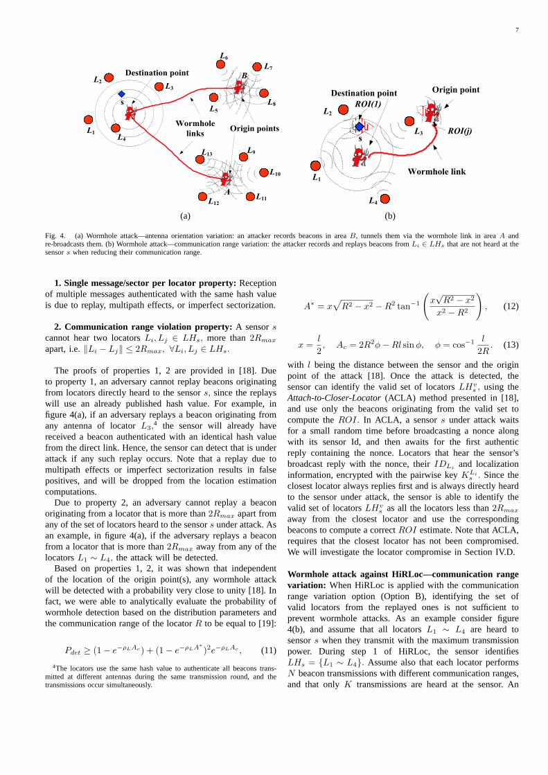
(a) (b)
Fig. 5. An adversary assumes the IDs of locatorsL5 ∼ L9 fabricates bogus beacons and displaces the sensor to an arbitrary location, (b)P (|LHs| ≥ Lmax),vs. Lmax for varying locator densitiesρL.
adversary being located at the origin point can record andreplay to the sensor up to(4N − K) beacons not heard tothe sensor and displace it.
Defending against the wormhole attack—communicationrange variation In the case of the communication rangevariation the detection method based on properties 1, 2 cannotprevent the attack as illustrated by the previous example.However, we can still detect a wormhole attack using thefollowing approach:
Instead of computing theROI after the collection of allbeacon transmissions, the sensor computes an estimate of theROI(1) by using all the beacons transmitted with the maxi-mum communication range. The computation of theROI(1)is identical to the computation of theROI in the case ofthe SeRLoc [18]. Once the initial estimate of theROI(1) iscomputed robustly, any subsequent estimation of theROI(j)must intersect with the initial one. Since subsequentROIestimates are refinements ofROI(1), if the sensor computesa ROI(j) that does not intersect with the initial one, it detectsthat it is under attack. Hence, an adversary can only hope todisplace the sensor within the region of the initial estimationof the ROI(1).
In our example in 4(b), the sensor initially computes theROI(1) located around its actual location. The replay of thebeacons from the origin point generate aROI(j) around theorigin point that does not intersect with the initial estimate ofthe ROI(1). Hence, the attack is detected and the beaconsintersection inROI(j) are rejected.
C. Sybil Attack
Threat model: In the Sybil attack [9], [13], [33], an adversaryimpersonates multiple network entities, by assuming theirIDs. In a network where data are encrypted and the ID ofeach transmitting entity is authenticated, unlike the wormholeattack, the adversary has to both compromise the encryptionand authenticity of the communication in order to successfullylaunch a Sybil attack. In HiRLoc, sensors determine theirlocation based on information transmitted only by locators.Hence, an attacker can only impact the localization if it
impersonates locators. In our attack analysis against HiRLocwe focus on locator impersonation.
Sybil attack against HiRLoc—antenna orientation varia-tion: In order for an attacker to impersonate a locator andprovide bogus beacon information to a sensors, the attackerhas to, (a) compromise the globally shared keyK0 used forthe beacon encryption, (b) acquire a published hash value froma locator not directly heard by the sensors5.
Once the attacker compromisesK0, it can record abeacon from a locator not heard bys, decrypt the beaconusing K0, alter the beacon content, and forward the bogusbeacon to sensors. Since the sensor does not directly hear thetransmission from the impersonated locator, it will authenticatethe bogus beacon. By impersonating sufficient number oflocators, the attacker can forward to a sensors a highernumber of bogus beacons than the valid ones, compromisethe majority vote scheme, and displaces. In figure 5(a)the attacker decrypts all beacons received from locatorsL5 ∼ L9 and acquires the published hash values, duringall transmission rounds of the antenna orientation variation.Using the hash values it can fabricate any desired beacon andforward it to sensors. Since the fabricated beacons are morethan the valid ones, the sensor is displaced at an arbitrary area.
Defense against the Sybil attack:Since the locators arerandomly distributed, on average, each sensor will hear thesame number of locators. Hence, when a sensor is underattack, it will hear an unusually high number of locators (morethan double the valid ones). We can use our knowledge of thelocator distribution to detect the Sybil attack by selecting athreshold valueLmax as the maximum allowable number oflocators heard by each sensor. If a sensor hears more thanLmax locators, it assumes that is under attack and executesALCA to determine its position. Since ACLA utilizes the pair-wise keysKLi
s to identify the valid set of locators, the Sybilattack will not be successful, unless the attacker compromiseslocators. We will analyze the locator compromise case in the
5The sensor always has the latest published hash values of the hash chainsfrom the locators directly heard by it.
9
Enhanced Location Resolution Algorithm (ELRA)
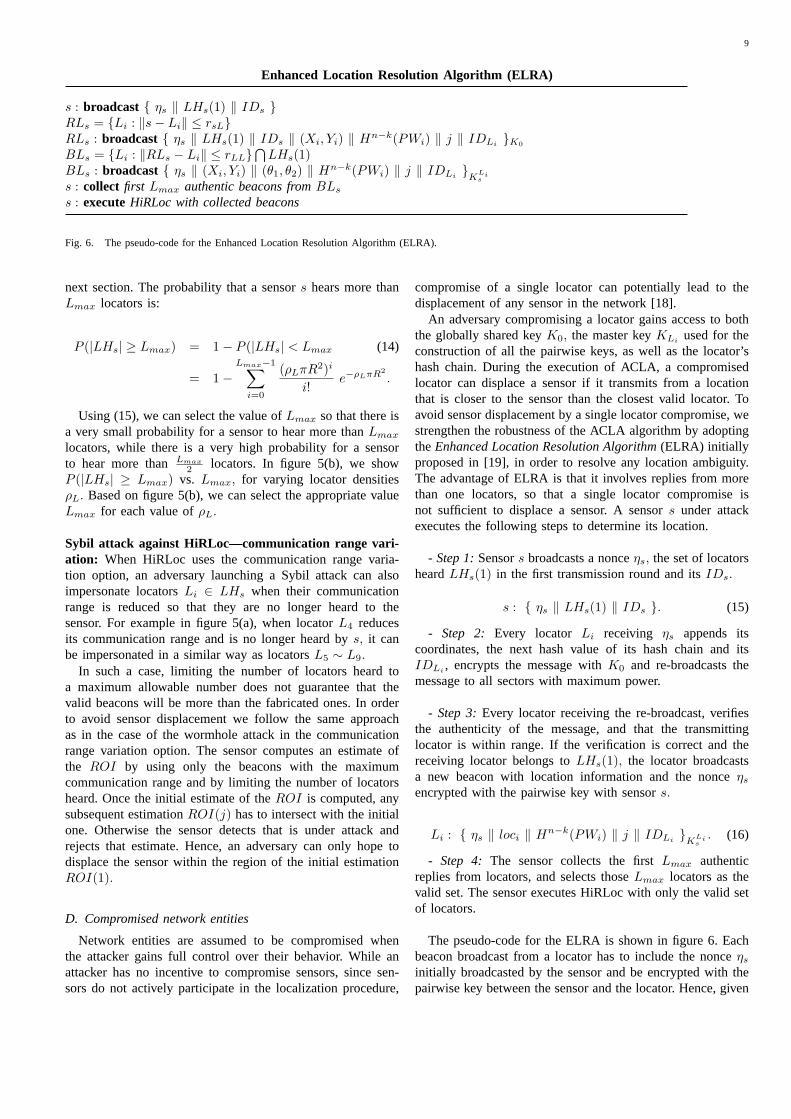
s : broadcast { ηs ‖ LHs(1) ‖ IDs }RLs = {Li : ‖s− Li‖ ≤ rsL}RLs : broadcast { ηs ‖ LHs(1) ‖ IDs ‖ (Xi, Yi) ‖ Hn−k(PWi) ‖ j ‖ IDLi
}K0
BLs = {Li : ‖RLs − Li‖ ≤ rLL}⋂
LHs(1)BLs : broadcast { ηs ‖ (Xi, Yi) ‖ (θ1, θ2) ‖ Hn−k(PWi) ‖ j ‖ IDLi }K
Lis
s : collect first Lmax authentic beacons fromBLs
s : executeHiRLoc with collected beacons
Fig. 6. The pseudo-code for the Enhanced Location Resolution Algorithm (ELRA).
next section. The probability that a sensors hears more thanLmax locators is:
P (|LHs| ≥ Lmax) = 1− P (|LHs| < Lmax (14)
= 1−Lmax−1∑
i=0
(ρLπR2)i
i!e−ρLπR2
.
Using (15), we can select the value ofLmax so that there isa very small probability for a sensor to hear more thanLmax
locators, while there is a very high probability for a sensorto hear more thanLmax
2 locators. In figure 5(b), we showP (|LHs| ≥ Lmax) vs. Lmax, for varying locator densitiesρL. Based on figure 5(b), we can select the appropriate valueLmax for each value ofρL.
Sybil attack against HiRLoc—communication range vari-ation: When HiRLoc uses the communication range varia-tion option, an adversary launching a Sybil attack can alsoimpersonate locatorsLi ∈ LHs when their communicationrange is reduced so that they are no longer heard to thesensor. For example in figure 5(a), when locatorL4 reducesits communication range and is no longer heard bys, it canbe impersonated in a similar way as locatorsL5 ∼ L9.
In such a case, limiting the number of locators heard toa maximum allowable number does not guarantee that thevalid beacons will be more than the fabricated ones. In orderto avoid sensor displacement we follow the same approachas in the case of the wormhole attack in the communicationrange variation option. The sensor computes an estimate ofthe ROI by using only the beacons with the maximumcommunication range and by limiting the number of locatorsheard. Once the initial estimate of theROI is computed, anysubsequent estimationROI(j) has to intersect with the initialone. Otherwise the sensor detects that is under attack andrejects that estimate. Hence, an adversary can only hope todisplace the sensor within the region of the initial estimationROI(1).
D. Compromised network entities
Network entities are assumed to be compromised whenthe attacker gains full control over their behavior. While anattacker has no incentive to compromise sensors, since sen-sors do not actively participate in the localization procedure,
compromise of a single locator can potentially lead to thedisplacement of any sensor in the network [18].
An adversary compromising a locator gains access to boththe globally shared keyK0, the master keyKLi
used for theconstruction of all the pairwise keys, as well as the locator’shash chain. During the execution of ACLA, a compromisedlocator can displace a sensor if it transmits from a locationthat is closer to the sensor than the closest valid locator. Toavoid sensor displacement by a single locator compromise, westrengthen the robustness of the ACLA algorithm by adoptingtheEnhanced Location Resolution Algorithm(ELRA) initiallyproposed in [19], in order to resolve any location ambiguity.The advantage of ELRA is that it involves replies from morethan one locators, so that a single locator compromise isnot sufficient to displace a sensor. A sensors under attackexecutes the following steps to determine its location.
- Step 1:Sensors broadcasts a nonceηs, the set of locatorsheardLHs(1) in the first transmission round and itsIDs.
s : { ηs ‖ LHs(1) ‖ IDs }. (15)
- Step 2: Every locator Li receiving ηs appends itscoordinates, the next hash value of its hash chain and itsIDLi , encrypts the message withK0 and re-broadcasts themessage to all sectors with maximum power.
- Step 3:Every locator receiving the re-broadcast, verifiesthe authenticity of the message, and that the transmittinglocator is within range. If the verification is correct and thereceiving locator belongs toLHs(1), the locator broadcastsa new beacon with location information and the nonceηs
encrypted with the pairwise key with sensors.
Li : { ηs ‖ loci ‖ Hn−k(PWi) ‖ j ‖ IDLi }KLis
. (16)
- Step 4: The sensor collects the firstLmax authenticreplies from locators, and selects thoseLmax locators as thevalid set. The sensor executes HiRLoc with only the valid setof locators.
The pseudo-code for the ELRA is shown in figure 6. Eachbeacon broadcast from a locator has to include the nonceηs
initially broadcasted by the sensor and be encrypted with thepairwise key between the sensor and the locator. Hence, given
10
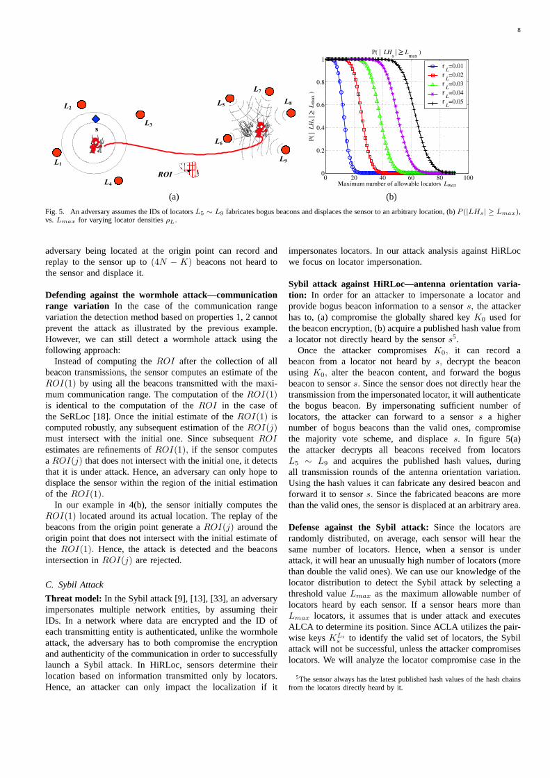
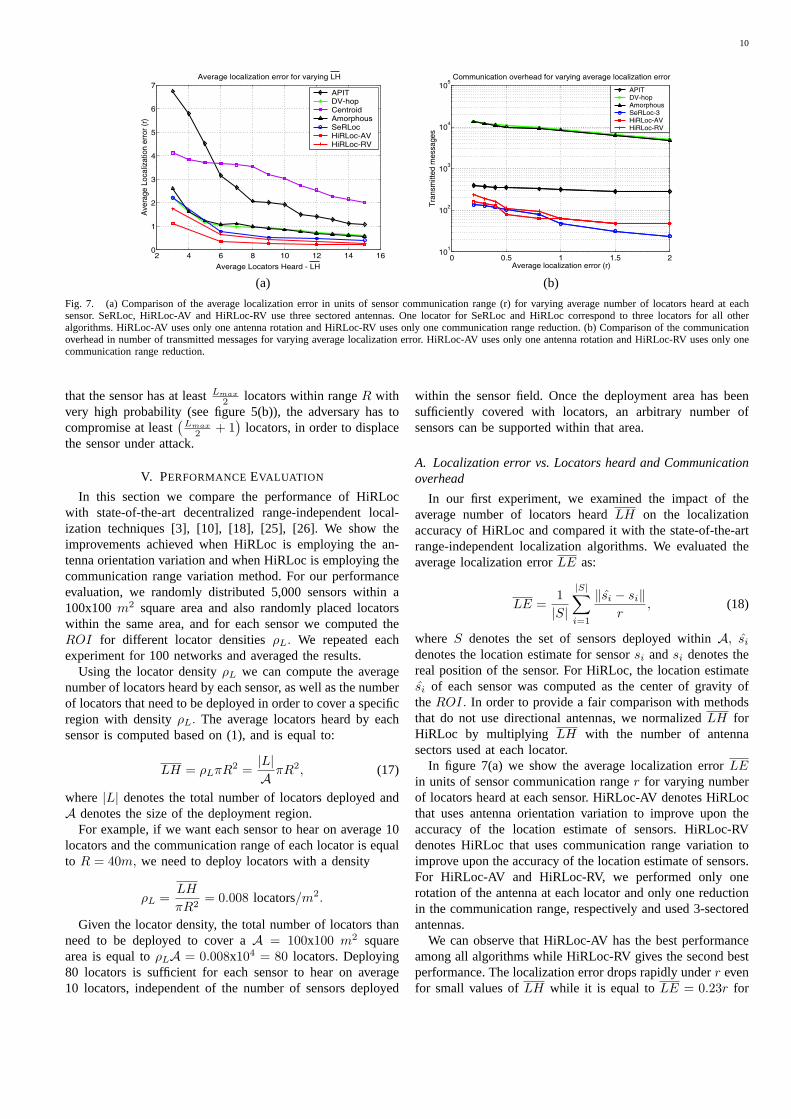
(a) (b)
Fig. 7. (a) Comparison of the average localization error in units of sensor communication range (r) for varying average number of locators heard at eachsensor. SeRLoc, HiRLoc-AV and HiRLoc-RV use three sectored antennas. One locator for SeRLoc and HiRLoc correspond to three locators for all otheralgorithms. HiRLoc-AV uses only one antenna rotation and HiRLoc-RV uses only one communication range reduction. (b) Comparison of the communicationoverhead in number of transmitted messages for varying average localization error. HiRLoc-AV uses only one antenna rotation and HiRLoc-RV uses only onecommunication range reduction.
that the sensor has at leastLmax
2 locators within rangeR withvery high probability (see figure 5(b)), the adversary has tocompromise at least
(Lmax
2 + 1)
locators, in order to displacethe sensor under attack.
V. PERFORMANCEEVALUATION
In this section we compare the performance of HiRLocwith state-of-the-art decentralized range-independent local-ization techniques [3], [10], [18], [25], [26]. We show theimprovements achieved when HiRLoc is employing the an-tenna orientation variation and when HiRLoc is employing thecommunication range variation method. For our performanceevaluation, we randomly distributed 5,000 sensors within a100x100m2 square area and also randomly placed locatorswithin the same area, and for each sensor we computed theROI for different locator densitiesρL. We repeated eachexperiment for 100 networks and averaged the results.
Using the locator densityρL we can compute the averagenumber of locators heard by each sensor, as well as the numberof locators that need to be deployed in order to cover a specificregion with densityρL. The average locators heard by eachsensor is computed based on (1), and is equal to:
LH = ρLπR2 =|L|A πR2, (17)
where |L| denotes the total number of locators deployed andA denotes the size of the deployment region.
For example, if we want each sensor to hear on average 10locators and the communication range of each locator is equalto R = 40m, we need to deploy locators with a density
ρL =LH
πR2= 0.008 locators/m2.
Given the locator density, the total number of locators thanneed to be deployed to cover aA = 100x100 m2 squarearea is equal toρLA = 0.008x104 = 80 locators. Deploying80 locators is sufficient for each sensor to hear on average10 locators, independent of the number of sensors deployed
within the sensor field. Once the deployment area has beensufficiently covered with locators, an arbitrary number ofsensors can be supported within that area.
A. Localization error vs. Locators heard and Communicationoverhead
In our first experiment, we examined the impact of theaverage number of locators heardLH on the localizationaccuracy of HiRLoc and compared it with the state-of-the-artrange-independent localization algorithms. We evaluated theaverage localization errorLE as:
LE =1|S|
|S|∑
i=1
‖si − si‖r
, (18)
where S denotes the set of sensors deployed withinA, si
denotes the location estimate for sensorsi andsi denotes thereal position of the sensor. For HiRLoc, the location estimatesi of each sensor was computed as the center of gravity oftheROI. In order to provide a fair comparison with methodsthat do not use directional antennas, we normalizedLH forHiRLoc by multiplying LH with the number of antennasectors used at each locator.
In figure 7(a) we show the average localization errorLEin units of sensor communication ranger for varying numberof locators heard at each sensor. HiRLoc-AV denotes HiRLocthat uses antenna orientation variation to improve upon theaccuracy of the location estimate of sensors. HiRLoc-RVdenotes HiRLoc that uses communication range variation toimprove upon the accuracy of the location estimate of sensors.For HiRLoc-AV and HiRLoc-RV, we performed only onerotation of the antenna at each locator and only one reductionin the communication range, respectively and used 3-sectoredantennas.
We can observe that HiRLoc-AV has the best performanceamong all algorithms while HiRLoc-RV gives the second bestperformance. The localization error drops rapidly underr evenfor small values ofLH while it is equal toLE = 0.23r for
11
0 0.5 1 1.5 2 2.5 30.1
0.2
0.3
0.4
0.5
0.6
0.7
0.8
0.9
1
Number of antenna rotations
Nor
mal
ized
R
OI
HiRLoc−AV: Antenna orientation variation
3−sector4−sector6−sector 8−sector16−sector
(a) (b)
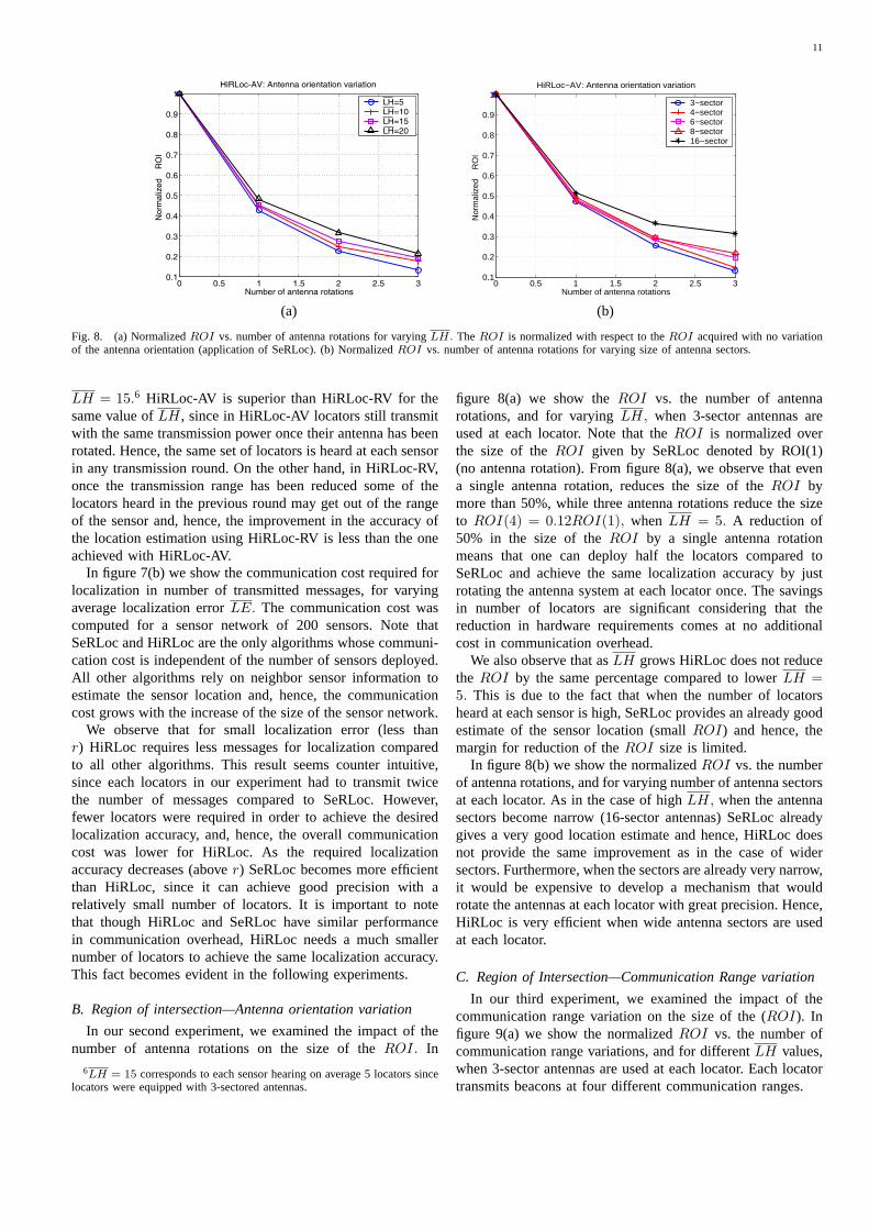
Fig. 8. (a) NormalizedROI vs. number of antenna rotations for varyingLH. The ROI is normalized with respect to theROI acquired with no variationof the antenna orientation (application of SeRLoc). (b) NormalizedROI vs. number of antenna rotations for varying size of antenna sectors.
LH = 15.6 HiRLoc-AV is superior than HiRLoc-RV for thesame value ofLH, since in HiRLoc-AV locators still transmitwith the same transmission power once their antenna has beenrotated. Hence, the same set of locators is heard at each sensorin any transmission round. On the other hand, in HiRLoc-RV,once the transmission range has been reduced some of thelocators heard in the previous round may get out of the rangeof the sensor and, hence, the improvement in the accuracy ofthe location estimation using HiRLoc-RV is less than the oneachieved with HiRLoc-AV.
In figure 7(b) we show the communication cost required forlocalization in number of transmitted messages, for varyingaverage localization errorLE. The communication cost wascomputed for a sensor network of 200 sensors. Note thatSeRLoc and HiRLoc are the only algorithms whose communi-cation cost is independent of the number of sensors deployed.All other algorithms rely on neighbor sensor information toestimate the sensor location and, hence, the communicationcost grows with the increase of the size of the sensor network.
We observe that for small localization error (less thanr) HiRLoc requires less messages for localization comparedto all other algorithms. This result seems counter intuitive,since each locators in our experiment had to transmit twicethe number of messages compared to SeRLoc. However,fewer locators were required in order to achieve the desiredlocalization accuracy, and, hence, the overall communicationcost was lower for HiRLoc. As the required localizationaccuracy decreases (abover) SeRLoc becomes more efficientthan HiRLoc, since it can achieve good precision with arelatively small number of locators. It is important to notethat though HiRLoc and SeRLoc have similar performancein communication overhead, HiRLoc needs a much smallernumber of locators to achieve the same localization accuracy.This fact becomes evident in the following experiments.
B. Region of intersection—Antenna orientation variation
In our second experiment, we examined the impact of thenumber of antenna rotations on the size of theROI. In
6LH = 15 corresponds to each sensor hearing on average 5 locators sincelocators were equipped with 3-sectored antennas.
figure 8(a) we show theROI vs. the number of antennarotations, and for varyingLH, when 3-sector antennas areused at each locator. Note that theROI is normalized overthe size of theROI given by SeRLoc denoted by ROI(1)(no antenna rotation). From figure 8(a), we observe that evena single antenna rotation, reduces the size of theROI bymore than 50%, while three antenna rotations reduce the sizeto ROI(4) = 0.12ROI(1), when LH = 5. A reduction of50% in the size of theROI by a single antenna rotationmeans that one can deploy half the locators compared toSeRLoc and achieve the same localization accuracy by justrotating the antenna system at each locator once. The savingsin number of locators are significant considering that thereduction in hardware requirements comes at no additionalcost in communication overhead.
We also observe that asLH grows HiRLoc does not reducethe ROI by the same percentage compared to lowerLH =5. This is due to the fact that when the number of locatorsheard at each sensor is high, SeRLoc provides an already goodestimate of the sensor location (smallROI) and hence, themargin for reduction of theROI size is limited.
In figure 8(b) we show the normalizedROI vs. the numberof antenna rotations, and for varying number of antenna sectorsat each locator. As in the case of highLH, when the antennasectors become narrow (16-sector antennas) SeRLoc alreadygives a very good location estimate and hence, HiRLoc doesnot provide the same improvement as in the case of widersectors. Furthermore, when the sectors are already very narrow,it would be expensive to develop a mechanism that wouldrotate the antennas at each locator with great precision. Hence,HiRLoc is very efficient when wide antenna sectors are usedat each locator.
C. Region of Intersection—Communication Range variation
In our third experiment, we examined the impact of thecommunication range variation on the size of the (ROI). Infigure 9(a) we show the normalizedROI vs. the number ofcommunication range variations, and for differentLH values,when 3-sector antennas are used at each locator. Each locatortransmits beacons at four different communication ranges.
12
0 0.5 1 1.5 2 2.5 30.3
0.4
0.5
0.6
0.7
0.8
0.9
1
Number of range variations
Nor
mal
ized
R
OI
HiRLoc−RV: Communication range variation
3−sector4−sector6−sector 8−sector16−sector
(a) (b)
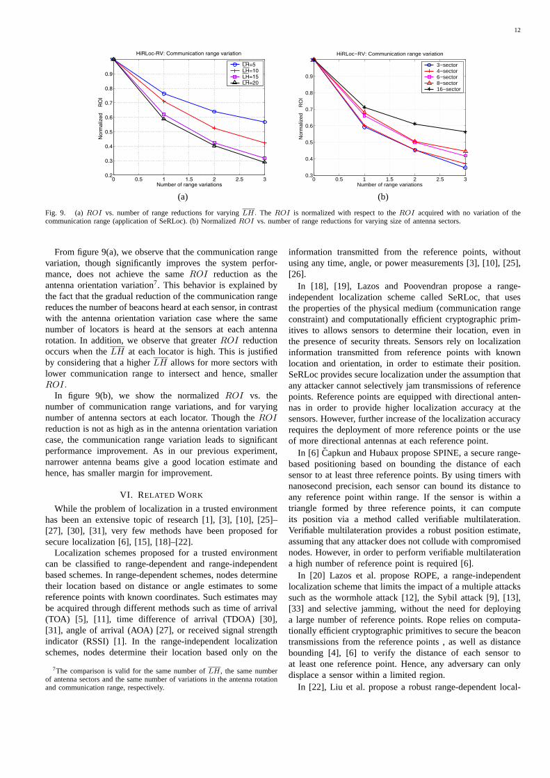
Fig. 9. (a)ROI vs. number of range reductions for varyingLH. The ROI is normalized with respect to theROI acquired with no variation of thecommunication range (application of SeRLoc). (b) NormalizedROI vs. number of range reductions for varying size of antenna sectors.
From figure 9(a), we observe that the communication rangevariation, though significantly improves the system perfor-mance, does not achieve the sameROI reduction as theantenna orientation variation7. This behavior is explained bythe fact that the gradual reduction of the communication rangereduces the number of beacons heard at each sensor, in contrastwith the antenna orientation variation case where the samenumber of locators is heard at the sensors at each antennarotation. In addition, we observe that greaterROI reductionoccurs when theLH at each locator is high. This is justifiedby considering that a higherLH allows for more sectors withlower communication range to intersect and hence, smallerROI.
In figure 9(b), we show the normalizedROI vs. thenumber of communication range variations, and for varyingnumber of antenna sectors at each locator. Though theROIreduction is not as high as in the antenna orientation variationcase, the communication range variation leads to significantperformance improvement. As in our previous experiment,narrower antenna beams give a good location estimate andhence, has smaller margin for improvement.
VI. RELATED WORK
While the problem of localization in a trusted environmenthas been an extensive topic of research [1], [3], [10], [25]–[27], [30], [31], very few methods have been proposed forsecure localization [6], [15], [18]–[22].
Localization schemes proposed for a trusted environmentcan be classified to range-dependent and range-independentbased schemes. In range-dependent schemes, nodes determinetheir location based on distance or angle estimates to somereference points with known coordinates. Such estimates maybe acquired through different methods such as time of arrival(TOA) [5], [11], time difference of arrival (TDOA) [30],[31], angle of arrival (AOA) [27], or received signal strengthindicator (RSSI) [1]. In the range-independent localizationschemes, nodes determine their location based only on the
7The comparison is valid for the same number ofLH, the same numberof antenna sectors and the same number of variations in the antenna rotationand communication range, respectively.
information transmitted from the reference points, withoutusing any time, angle, or power measurements [3], [10], [25],[26].
In [18], [19], Lazos and Poovendran propose a range-independent localization scheme called SeRLoc, that usesthe properties of the physical medium (communication rangeconstraint) and computationally efficient cryptographic prim-itives to allows sensors to determine their location, even inthe presence of security threats. Sensors rely on localizationinformation transmitted from reference points with knownlocation and orientation, in order to estimate their position.SeRLoc provides secure localization under the assumption thatany attacker cannot selectively jam transmissions of referencepoints. Reference points are equipped with directional anten-nas in order to provide higher localization accuracy at thesensors. However, further increase of the localization accuracyrequires the deployment of more reference points or the useof more directional antennas at each reference point.
In [6] Capkun and Hubaux propose SPINE, a secure range-based positioning based on bounding the distance of eachsensor to at least three reference points. By using timers withnanosecond precision, each sensor can bound its distance toany reference point within range. If the sensor is within atriangle formed by three reference points, it can computeits position via a method called verifiable multilateration.Verifiable multilateration provides a robust position estimate,assuming that any attacker does not collude with compromisednodes. However, in order to perform verifiable multilaterationa high number of reference point is required [6].
In [20] Lazos et al. propose ROPE, a range-independentlocalization scheme that limits the impact of a multiple attackssuch as the wormhole attack [12], the Sybil attack [9], [13],[33] and selective jamming, without the need for deployinga large number of reference points. Rope relies on computa-tionally efficient cryptographic primitives to secure the beacontransmissions from the reference points , as well as distancebounding [4], [6] to verify the distance of each sensor toat least one reference point. Hence, any adversary can onlydisplace a sensor within a limited region.
In [22], Liu et al. propose a robust range-dependent local-
13
ization method that uses Minimum Mean Square Estimation(MMSE) to filter outliers, and compute the position of thesensors using a consistent set of range estimates. The methodpresented in [22] prevents attackers from displacing sensorsby corrupting a small set of range estimates. However, thevalid set of range estimates cannot be identified if the attackersuccessfully corrupts a large set of range estimates (more thanthe benign ones).
In [21], Li et al. propose the use of robust statistical methodsfor filtering out the outliers in the sample set used to estimatethe sensors’ location. The authors illustrate how they canlimit the impact of the outliers by employing a Least MedianSquares (LMS) technique. As in the case of the method in [22],the authors make the implicit assumption that the majority ofthe observations collected by each sensor are benign and onlya few samples are corrupted. However, in specific types ofattacks such as the wormhole [12] and Sybil attack [9], themajority of the samples can be malicious.
VII. D ISCUSSION ANDOPEN PROBLEMS
The localization schemes that have been proposed forrobust estimation of the position of sensors in the presenceof adversaries can be classified into two main classes. Theschemes proposed in [21], [22], do not consider a specificadversarial model. Instead, they consider that some fraction ofthe localization information is corrupted, while the majority ofthe observations are benign. The information can be corruptedeither due to network faults or due to some type of attack.Using statistical methods, schemes of the first class filter outoutliers and estimate the position of sensors by consideringonly a consistent subset of the set of the collected observations.The schemes proposed in [6], [18]–[20], consider specificadversarial models and examine the potential attacks an ad-versary can launch in order to disrupt the localization process.Using the characteristics of the adversarial models, schemesof this class propose mechanisms to secure the localizationagainst the different types of feasible attacks.
HiRLoc belongs to the second class of algorithms wherea specific adversarial model is considered. We have shownthat an adversary cannot disrupt HiRLoc by corrupting rangeestimates, since no such estimates are used to compute theposition of sensors. An attacker can potentially enlarge thecommunication range of the locators in an effort to displacethe sensors. However such an enlargement is equivalent to thewormhole attack that is detected and prevented with a veryhigh probability when using HiRLoc as presented in SectionIV-B. An attacker can also attempt to reduce the communica-tion range of the locators. A reduction in communication rangedoes not lead to sensor displacement since any sensor hearinga locator will still be within the nominal communication rangeeven if it has been reduced by some attack.
In addition, an adversary attempting to disrupt HiRLoc gainsno benefit from compromising sensor nodes since sensorsdo not assist in the localization of other sensors. The onlyusable information extracted from compromising a sensor isthe globally shared keyK0. Though a single sensor compro-mise reveals theK0, broadcasting with a commonly shared
key is the most bandwidth and energy-efficient solution. Theadversary can only useK0 to launch a Sybil attack. However,the Sybil attack can be prevented with a high probability aspresented in Section IV-C. In the case where a higher levelof security is required compared to the one offered by theglobally shared key, one can adopt the broadcast authenticationtechniques as in [23], [29]. However, both those techniquesrequire time synchronization among all nodes of the networknot currently required for HiRLoc.
In HiRLoc, an attacker can successfully displace sensorsby compromising a threshold number of locators (referencepoint). However, as with any localization algorithm, if thecoordinate system used to localize the sensor is false, then thelocation estimation is false. In addition, an adversary is ableto displace sensors if it can selectively jam transmissions oflocators. HiRLoc is not jamming resistant. However, such afeature can be added in HiRLoc by employing the distancebounding technique presented in [4], [6], [20]. Jammingresistance comes at the expense of hardware complexity,since sensors need to be equipped with clocks of nanosecondprecision in order to perform distance bounding.
On the other hand the methods using robust statisticalmethods [21], [22] do not attempt to prevent any specific typeof attack. They provide a robust estimate of the position of thesensors as long as the majority of the observations are benign.Though most observations collected in the whole networkmay be benign, an adversary can launch attacks to pocketsof the network and corrupt the majority of the observationsin a confined network region. As an example consider thewormhole attack described in Section IV-B. In such an attack,the beacons replayed by the attacker provide false localizationinformation to a specific set of sensors. For the sensors underattack the localization process is compromised if the replayedbeacons are more than the benign ones. Statistical methodsthat rely on the detection of consistent subsets of information,will fail to discern the replayed beacons from the valid onesand accept the replayed set of beacons as the most consistentone.
Both classes of solutions to the robust sensor localizationproblem are by no means perfectly secure to adversaries. Infact, due to the resource constraint nature of the sensor devices,there is a tradeoff between the robustness in the locationestimation and the hardware and computational complexity.From the related work, it is evident that no single approachcan prevent all types of attacks. A multi-modal approach thattakes into account multiple features of the sensor network isrequired in order to build a robust localization system. Finally,a formal classification of the threat models and their directrelation with the localization error is needed.
VIII. C ONCLUSION
We studied the problem of sensor localization in the pres-ence of malicious adversaries and proposed a high-resolutionrange-independent localization scheme called HiRLoc. Weshowed that HiRLoc localizes sensors with significantly higheraccuracy than previously proposed methods, while requir-ing fewer hardware resources. Furthermore, we showed that
14
HiRLoc allows the robust location computation even in thepresence of security threats in WSN, such as the wormhole at-tack, the Sybil attack and compromise of network entities. Oursimulation studies confirmed that variation of the transmissionparameters at the reference points leads to high-resolutionlocation estimation.
ACKNOWLEDGEMENTS
This work was supported in part by the followinggrants: Collaborative Technology Alliance (CTA) from ARL,DAAD19-01-2-0011; ONR award, N00014-04-1-0479; AROgrant, W911NF-05-1-0491. We would like to thank anony-mous reviewers for their valuable comments.
REFERENCES
[1] P. Bahl and V. Padmanabhan, RADAR: An In-Building RF-Based UserLocation and Tracking System, InProceedings of the IEEE INFOCOM,Tel-Aviv, Israel, March 2000, pp. 775–784.
[2] S. Basagni, I. Chlamtac, V. Syrotiuk, and B. Woodward, A DistanceRouting Effect Algorithm for Mobility (DREAM), InProceedings ofMOBICOM, Dallas, TX, USA, Oct. 1998, pp.76–84
[3] N. Bulusu, J. Heidemann and D. Estrin, GPS-less Low Cost OutdoorLocalization for Very Small Devices, InIEEE Personal CommunicationsMagazine,7(5):28-34, Oct. 2000.
[4] S. Brands and D. Chaum, Distance-bounding protocols, In Workshop onthe theory and application of cryptographic techniques on Advances incryptology, pp. 344-359. Springer-Verlag New York, Inc., 1994.
[5] S. Capkun, M. Hamdi and J. Hubaux, GPS-Free Positioning in MobileAd-Hoc Networks, InProceedings of HICCSS,Maui, Hawaii, USA, Jan.2001, pp. 3481–3490.
[6] S. Capkun, J. Hubaux, Secure Positioning of Wireless Devices withApplication to Sensor Networks, InProceedings of the IEEE INFOCOM,2005.
[7] D. Coppersmith and M. Jakobsson, Almost optimal hash sequencetraversal, InProceedings of the FC,Lecture Notes in Computer Science,IFCA, Springer-Verlag, Berlin Germany, 2002, pp. 102–119.
[8] N. Cressie,Statistics for Spatial Data,John Wiley & Sons, 1993.[9] J. Douceur, The Sybil Attack, InProceedings of IPTPS 2002,Lecture
Notes in Computer Science, Vol. 2429 Cambridge, MA, USA, March2002, pp. 251–260.
[10] T. He, C. Huang, B. Blum, J. Stankovic and T. Abdelzaher, Range-FreeLocalization Schemes in Large Scale Sensor Network, InProceedingsof MOBICOM,San Diego, CA, USA, Sept. 2003, pp. 81–95.
[11] B. Hofmann-Wellenhof, H. Lichtenegger and J. Collins,Global Posi-tioning System: Theory and Practice,Fourth Edition, Springer-Verlag,1997.
[12] Y. Hu, A. Perrig, and D. Johnson, Packet Leashes: A Defense AgainstWormhole Attacks in Wireless Ad Hoc Networks, InProceedings ofINFOCOM, San Francisco, CA, USA, April 2003, pp. 1976-1986.
[13] J. Newsome, E. Shi, D. Song and A. Perrig, The Sybil Attack inSensor Networks: Analysis and Defenses, InProceedings of the ThirdInternational Conference on Information Processing in Sensor Networks,IPSN 2004, pp. 259–268.
[14] C. Karlof and D. Wagner, Secure routing in wireless sensor networks:Attacks and countermeasures, InProceedings of the 1st IEEE Interna-tional Workshop on Sensor Network Protocols and Applications,May2002.
[15] M. G. Kuhn, An Asymmetric Security Mechanism for NavigationSignals, InProceedings of the Information Hiding Workshop, 2004.
[16] L. Lamport, Password Authentication with Insecure Communication, InCommunications of the ACM,24(11):770− 772, November 1981.
[17] L. Lazos and R. Poovendran, Energy-Aware Secure Multicast Commu-nication in Ad-hoc Networks Using Geographic Location Information,In Proceedings of IEEE ICASSP,Hong Kong, China, April 2003, Vol.6, pp. 201–204.
[18] L. Lazos and R. Poovendran, SeRLoc: Secure Range-Independent Lo-calization for Wireless Sensor Networks, to appear inProceedings ofWISE,Philadelphia, PA, Oct. 2004, pp. 21–30.
[19] L. Lazos and R. Poovendran, Robust Range-independent Localizationfor Wireless Sensor Networks, to appear InTransactions on SensorNetworks,available upon request.
[20] L. Lazos, S. Capkun, and R. Poovendran, ROPE: Robust PositionEstimation in Wireless Sensor Networks, InProceedings of the FourthInternational Conference on Information Processing in Sensor Networks,IPSN 2005, pp. 324–331.
[21] Z. Li, W. Trappe, Y. Zhang, and B. Nath, Robust Statistical Methodsfor Securing Wireless Localization in Sensor Networks, InProceedingsof Proceedings of the Fourth International Conference on InformationProcessing in Sensor Networks, IPSN 2005, pp. 91–98.
[22] D. Liu, P. Ning, and W. Du, Attack-Resistant Location Estimationin Sensor Networks, InProceedings of Proceedings of the FourthInternational Conference on Information Processing in Sensor Networks,IPSN 2005, pp. 99–107.
[23] D. Liu, P. Ning, Multi-Level µTESLA: Broadcast Authentication forDistributed Sensor Networks, InProceedings of the ACM Transactionsin Embedded Computing Systems (TECS),Vol. 3, No. 4, pages 800–836,Nov 2004.
[24] MICA Wireless Measurement System, available at:http://www.xbow.com/Products/Productpdf files/Wirelesspdf/MICA.pdf.
[25] R. Nagpal, H. Shrobe, J. Bachrach, Organizing a Global CoordinateSystem from Local Information on an Ad Hoc Sensor Network, InProceedings of IPSN,Palo Alto, USA, April, 2003, Lecture Notes inComputer Science, Vol. 2634, pp. 333–348.
[26] D. Nicolescu and B. Nath, Ad-Hoc Positioning Systems (APS), InProceedings of IEEE GLOBECOM,San Antonio, TX, USA, Nov. 2001,Vol. 5, pp. 2926–2931.
[27] D. Niculescu and B. Nath, Ad Hoc Positioning System (APS) usingAoA, In Proceedings of INFOCOM,San Francisco, CA, USA, March2003, Vol. 3, pp. 1734–1743.
[28] P. Papadimitratos and Z. J. Haas, Secure Routing for Mobile Ad HocNetworks, inProceedings of CNDS, Jan. 2002.
[29] A. Perrig, R. Szewczyk, V. Wen, D. Culler, and D. Tygar, SPINS:Security protocols for sensor networks, InProceedings of the SeventhAnnual International Conference on Mobile Computing and Networks,2001, pp. 189–199.
[30] N. Priyantha, A. Chakraborthy and H. Balakrishnan, The CricketLocation-Support System, InProceedings of MOBICOM,Boston, MA,USA, Aug. 2000, pp. 32-43.
[31] A. Savvides, C. Han and M. Srivastava, Dynamic Fine-Grained Local-ization in Ad-Hoc Networks of Sensors, InProceedings of MOBICOM,Rome, Italy, July 2001, pp. 166-179.
[32] D. Stinson,Cryptograhpy: Theory and Practice,2nd edition, CRC Press,2002.
[33] Q. Zhang, P. Wang, D. S. Reeves, and P. Ning, Defending Sybil Attacksin Sensor Networks, InProceedings of the International Workshop onSecurity in Distributed Computing Systems(SDCS-2005), June 2005.
Loukas Lazos is a Ph.D. student in the ElectricalEngineering Department at University of Washing-ton in Seattle. He received his M.S. degree fromthe same department in 2002 and his B.S. degreefrom the National Technical University of Athens,Greece, in 2000. His current research interests fo-cus on cross-layer designs for energy-efficient keymanagement protocols for wireless ad-hoc networks,as well as secure localization systems for sensornetworks.
Radha Poovendranhas been an assistant professorat the Electrical Engineering Department of theUniversity of Washington at Seattle since September2000. He received his Ph.D. in Electrical Engi-neering from the University of Maryland, CollegePark in 1999. His research interests are in the areasof applied cryptography for multiuser environment,wireless networking, and applications of InformationTheory to security. He is a recipient of the FacultyEarly Career Award from the National Science Foun-dation (2001), Young Investigator Award from the
Army Research Office (2002), Young Investigator Award from the Office ofNaval Research (2004), and the 2005 Presidential Early Career Award forScientists and Engineers, for his research contributions in the areas of wiredand wireless multiuser security.