hillwinds west river trail 10 7 hogle wildlife sanctuary ...faba8fb3-ebd9-4e2c-91f9... · the...
TRANSCRIPT
1
2
3
4
5
6
7
8
9
10
11
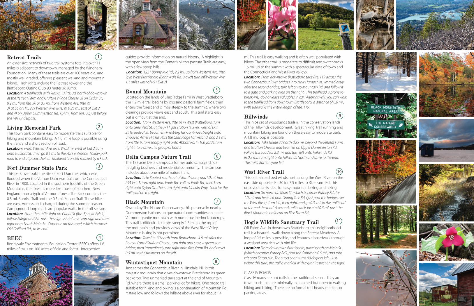
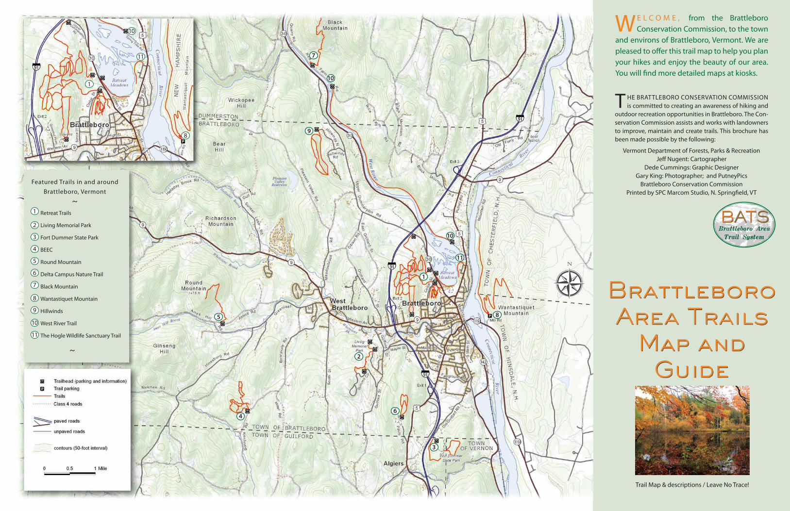
Retreat TrailsAn extensive network of two trail systems totaling over 11 miles is adjacent to downtown, managed by the Windham Foundation. Many of these trails are over 100 years old, and mostly well graded, offering pleasant walking and mountain biking. Highlights include the Retreat Tower and the Brattleboro Outing Club 90 meter ski jump. Location: 4 trailheads with kiosks: 1) Rte. 30, north of downtown at the Retreat Farm and Grafton Village Cheese; 2) on Cedar St., 0.2 mi. from Rte. 30 or 0.5 mi. from Western Ave. (Rte 9); 3) at Solar Hill, 289 Western Ave. (Rte. 9), 0.25 mi. east of Exit 2; and 4) on Upper Dummerston Rd., 0.4 mi. from Rte. 30, just before the I-91 underpass.
Living Memorial ParkThis town park contains easy to moderate trails suitable for hiking and mountain biking. A 1.0 mile loop is possible using the trails and a short section of road. Location: From Western Ave. (Rte. 9) 0.3 mi. west of Exit 2, turn onto Guilford St., then go 0.1 mi. to the Park entrance. Follow park road to end at picnic shelter. Trailhead is on left marked by a kiosk.
Fort Dummer State ParkThis park overlooks the site of Fort Dummer which was flooded when the Vernon Dam was built on the Connecticut River in 1908. Located in the southern foothills of the Green Mountains, the forest is more like those of southern New England than a typical Vermont forest. The Park contains the 0.8 mi. Sunrise Trail and the 0.5 mi. Sunset Trail. These hikes are easy. Admission is charged during the summer season. Campground loop roads are popular walks in the off season. Location: From the traffic light on Canal St (Rte. 5) near Exit 1, follow Fairground Rd. past the high school to a stop sign and turn right onto South Main St. Continue on this road, which becomes Old Guilford Rd., to its end.
BEECBonnyvale Environmental Education Center (BEEC) offers 1.6 miles of trails on 100 acres of field and forest. Interpretive
guides provide information on natural history. A highlight is the open view from the Center’s hilltop pasture. Trails are easy, with a few steep hills. Location: 1221 Bonnyvale Rd., 2.2 mi. up from Western Ave. (Rte. 9) in West Brattleboro (Bonnyvale Rd. is a left turn off Western Ave. 1.1 miles west of I-91 Exit 2).
Round MountainLocated on the lands of Lilac Ridge Farm in West Brattleboro, the 1.2 mile trail begins by crossing pastoral farm fields, then enters the forest and climbs steeply to the summit, where two clearings provide views east and south. This trail starts easy but is difficult at the end. Location: From Western Ave. (Rte. 9) in West Brattleboro, turn onto Greenleaf St. at the 7-11 gas station (1.3 mi. west of Exit 2). Greenleaf St. becomes Hinesburg Rd. Continue straight onto unpaved Ames Hill Rd. Pass the Lilac Ridge Farmstand, and 2.1 mi. from Rte. 9, turn sharply right onto Abbott Rd. In 100 yards, turn right into a drive at a group of barns.
Delta Campus Nature TrailThe 133 acre Delta Campus, a former auto scrap yard, is a fledgling business and residential community. The campus includes about one mile of nature trails.Location: Take Route 5 south out of Brattleboro, and1.0 mi. from I-91 Exit 1, turn right onto Pauls Rd. Follow Pauls Rd., then keep right onto Dylan Dr., then turn right onto Lincoln Way. Look for the trailhead on the right.
Black MountainOwned by The Nature Conservancy, this preserve in nearby Dummerston harbors unique natural communities on a rare Vermont granite mountain with numerous bedrock outcrops. This trail is difficult. It climbs steeply 1.3 mi. to the top of the mountain and provides views of the West River Valley. Mountain biking is not permitted. Location: Take Rte. 30 north from Brattleboro. 4.6 mi. after the Retreat Farm/Grafton Cheese, turn right and cross a green iron bridge, then immediately turn right onto Rice Farm Rd. and travel 0.5 mi. to the trailhead on the left.
Wantastiquet MountainJust across the Connecticut River in Hinsdale, NH is this majestic mountain that gives downtown Brattleboro its green backdrop. Two unmarked trails start at the end of Mountain Rd. where there is a small parking lot for hikers. One broad trail suitable for hiking and biking is a continuation of Mountain Rd; it stays low and follows the hillside above river for about 1.4
mi. This trail is easy walking and is often well populated with hikers. The other trail is moderate to difficult and switchbacks 1.5 mi. up to the summit with a spectacular vista of town and the Connecticut and West River valleys. Location: From downtown Brattleboro take Rte. 119 across the two Connecticut River bridges into New Hampshire. Immediately after the second bridge, turn left on to Mountain Rd. and follow it to a gate and parking area on the right. This trailhead is prone to break-ins; do not leave valuables in car. Alternatively, you can walk to the trailhead from downtown Brattleboro, a distance of 0.6 mi., with sidewalks the entire length of Rte. 119.
HillwindsThis nice set of woodlands trails is in the conservation lands of the Hillwinds development. Great hiking, trail running and mountain biking are found on these easy to moderate trails. A 1.8 mi. loop is possible. Location: Take Route 30 north 0.25 mi. beyond the Retreat Farm and Grafton Cheese, and bear left on Upper Dummerston Rd. Follow this road for 2.3 mi. and turn left onto Hillwinds Rd. In 0.2 mi., turn right onto Hillwinds North and drive to the end. The trails start on your left.
West River TrailThis old railroad bed winds north along the West River on the east side opposite Rt. 30 for 3.5 miles to Rice Farm Rd. This unpaved trail is ideal for easy mountain biking and hiking.Location: Go north on Main St, which becomes Putney Rd., for 1.0 mi. and bear left onto Spring Tree Rd. (just past the bridge over the West River). Turn left, then right, and go 0.3. mi. to the trailhead at the end the road. A second trailhead is located 0.5 mi. past the Black Mountain trailhead on Rice Farm Rd.
Hogle Wildlife Sanctuary TrailOff Eaton Ave. in downtown Brattleboro, this neighborhood trail is a beautiful walk down along the Retreat Meadows. A loop of 0.5 miles is possible, and features a boardwalk through a wetland area rich with bird life. Location: From downtown Brattleboro, travel north on Main St. (which becomes Putney Rd.), past the Common 0.5 mi., and turn left onto Eaton Ave. The street soon turns 90 degrees left. Just before this turn, the trail is marked with a granite post on the right.
CLASS IV ROADSClass IV roads are not trails in the traditional sense. They are town roads that are minimally maintained but open to walking, hiking and biking. There are no formal trail heads, markers or parking areas.
8
10
10
10
11
11
1
1
6
3
2
4
5
9
7
8
N
Retreat Trails
Living Memorial Park
Fort Dummer State Park
BEEC
Round Mountain
Delta Campus Nature Trail
Black Mountain
Wantastiquet Mountain
Hillwinds
West River Trail
The Hogle Wildlife Sanctuary Trail
~
1
3
4
5
6
7
8
9
10
11
2
Featured Trails in and around Brattleboro, Vermont
~
T HE BRATTLEBORO CONSERVATION COMMISSION is committed to creating an awareness of hiking and
outdoor recreation opportunities in Brattleboro. The Con-servation Commission assists and works with landowners to improve, maintain and create trails. This brochure has been made possible by the following:
Vermont Department of Forests, Parks & RecreationJeff Nugent: Cartographer
Dede Cummings: Graphic DesignerGary King: Photographer; and PutneyPics
Brattleboro Conservation CommissionPrinted by SPC Marcom Studio, N. Springfield, VT
WE L C O M E , from the Brattleboro Conservation Commission, to the town
and environs of Brattleboro, Vermont. We are pleased to offer this trail map to help you plan your hikes and enjoy the beauty of our area. You will find more detailed maps at kiosks.
BATS Brattleboro Area
Trail System
Trail Map & descriptions / Leave No Trace!
Brattleboro Area Trails
Map and Guide