habs historical reports - national park service historical reports: introduction, page 3...
TRANSCRIPT

HABS/HAER GUIDELINES
HABS HISTORICAL REPORTS
U.S. Department of the InteriorNational Park Service
Historic American Buildings Survey/Historic American Engineering Record
1849 C Street, NW, NC300Washington, DC 20240
(202) 343-9618http://www.cr.nps.gov/habshaer
October 2000

HABS/HAER GUIDELINES
HABS HISTORICAL REPORTS
TABLE OF CONTENTS
Introduction................................................................................................................................. 3Historian’s DutiesFormats.Completing the Historical Report
General Guidelines....................................................................................................................... 6Assigning Names to Structures and SitesDetermining Location
UrbanRural
HABS Number
Outline Format...............................................................................................................................10Identification InformationPart I. Historical InformationPart II. Architectural InformationPart III. Sources of InformationPart IV. Project Information
Outline Format Chart........................................................................................................ 17
Example No. 1 (No drawings or photographs accompany report)................................... 18
Example No. 2 (Report is part of comprehensive HABS documentation)....................... 25
Narrative Format.......................................................................................................................... 57
Short Format (with Example)....................................................................................................... 58
Supplemental Material.................................................................................................................. 60ExamplesGrammar and Punctuation
Front Cover: Mission San Juan y San Miguel de Aguayo, San Antonio, Bexar County, Texas.

HABS Historical Reports: Introduction, page 3
INTRODUCTION
Historic American Buildings Survey (HABS) documentation takes three forms:architectural measured drawings, large-format photography, and written reports. Theseguidelines are intended to direct you in the production of the last.
Like the rest of HABS documentation, the historical reports serve many purposes, someof which we cannot foresee at the time the documentation is produced. At the least, the reportsprovide raw data in an accessible format for easy use by future researchers. At its best, a HABShistorical report also synthesizes the information, making conclusions about the building beingdocumented, either through an analysis of the building itself and its history, or by setting it in anappropriate context.
For guidance in research techniques, analysis of buildings, and writing history, see the"History" chapter of Recording Historic Structures, ed. John A. Burns (Washington: AmericanInstitute of Architects Press, 1989). That basic handbook of the HABS/HAER program describesways of finding information on historic buildings and sites. These guidelines will discuss thearrangement of your information into a final report.
Historian's Duties
Although HABS receives documentation from many sources, these guidelines are directedat one producer of that documentation--the HABS summer historian. The Washington office ofHABS fields teams at sites all over the country, usually for twelve-week terms in the summer. HABS also receives documentation from the mitigation program, wherein HABS documentationmay be required in order to mitigate the adverse effects of a federal action. Generally thisdocumentation is produced by contractors to various agencies under the supervision of regionaloffice staff. Unlike the HABS summer projects, which terminate on a specific date, the mitigativedocumentation is not accepted by HABS until it has been edited and prepared for transmittal tothe Library of Congress. The requirements for that documentation are therefore slightly different,and an historian preparing documentation under that program should contact the appropriateregional office.
The HABS summer historian is usually based in the field with a team of architects or otherhistorians. The historian reports to two people: the head of the team (which is usually an architectif the team is composed largely of architects) and an historian in HABS's Washington office. Forissues such as work hours, access to buildings, and general day-to-day administration, the fieldteam leader is your boss. But for the content and format of the historical documentation, you areresponsible to the historian in Washington, hereafter referred to as the supervisor.
Besides producing an historical report to the supervisor's specifications, the historianshould also assist with the measured drawings and the large-format photography. The historianmight uncover or verify historical information that will appear on the HABS drawings; thehistorian might find original drawings to aid the architects in their work; or the historian mightdiscover information about additions or alterations helpful to understanding the building. Inaddition, the historian is responsible for writing the significance statement that appears on the titlesheet of the measured drawings; the precise wording and punctuation should be approved by yoursupervisor before it is inked. The historian should be aware that the building will most likely bedocumented with large-format photography, and be mindful of the types of photographs thatwould best illustrate the historical issues. Photographers often appear on site after the team hasgone home (winter being the best time to avoid excessive foliage), so it might be necessary toleave a list of desired photographs with your supervisor.

HABS Historical Reports: Introduction, page 4
The architects and photographers can also be helpful to the historians. The building itselfis one of the best research sources, and you can profit by the architects' experience with it. Walkthrough the building with the architects after they have become familiar with it. Not only will youlearn things about the building's history, but the description that you write will benefit by thearchitects' views.
The historian will also take photographs. Black-and-white prints, taken early in theproject, can serve as notes when researching or writing. Color slides are necessary for the finalpresentation to the community, when the historian may be called upon to present his/her findings. The architects will also be taking field photographs for their own use. If HABS provides the filmand pays for the developing, the photographs or slides are HABS property.
Outlines and drafts will be reviewed by your supervisor at the time indicated on a schedulethat you will both set at the beginning of the summer. Historians often have difficulty completingwork within the standard twelve-week HABS summer season. Most historians could spend twicethe amount of time available on any project. The extent of the documentation is determined bythe time available; don't bite off more than you can chew! If you work steadily through thesummer, you should be able to complete your project on time. Be sure to leave enough time towrite the report; it is easy to get carried away with the research. Some historians work well bywriting many drafts, adding information as they get it. Others like to accumulate everything theycan before committing one word to paper. Either way, you should schedule your work to have awritten draft by the beginning of August.
Eventually, the historical report will be sent to the Library of Congress with the historian'sname on it as author, as well as project information including the editor, supervisor, and othermembers of the team. HABS encourages its historians to publish their findings or to presentpapers on the project. Once at the Library the report is in the public domain, and anyone can usethe material.
Formats
Rather than prescribe a strict format for the written documentation, HABS prefers to letthe kind of structure or site being documented dictate the final form of that documentation. Atthe same time, we want to give some guidance to our historians in the field. HABS recommendsone of three formats to its historians: a narrative format, an outline format, and a short format. The narrative is divided into chapters or sections, emphasizing significant aspects of the buildingor site. The outline format prescribes aspects to be discussed, although sections can be expandedor deleted as appropriate. The short format is used when minimal information--not exceeding apage or two in length--has been collected.
The kinds of sites that are being documented by HABS have changed dramatically in thelast few decades. HABS initially concentrated its efforts on buildings constructed before the CivilWar--single buildings of simple forms, ideally suited to this outline format. More recently, HABShas been examining a broader range of resources, including collections of buildings,technologically complex buildings, landscapes, and urban plans. For these, narrative formats haveproven to be more useful, often used in conjunction with the outline format when specificbuildings or places were being discussed. Some examples of different kinds of projects, showingthe different forms that the historical documentation took, follow.
Rancho Santa Fe, California, was planned in the early 1920s as a community ofgentlemen-ranchers. Architect Lilian Rice designed an axially arrangedcommercial core and several buildings along it in a Spanish Revival style. Most of

HABS Historical Reports: General Guidelines, page 5
the houses in the community were built in this same style. To document thisunusual community, the historian produced a narrative overview of itsdevelopment, and HABS outline-format reports on the fifteen individual buildingsthat were documented by measured drawings.
The steel industry of southwestern Pennsylvania required vast amounts ofrefractory brick--brick that would withstand the high temperatures of the blastfurnaces. Refractory brickyards were established in the region, and workers werehoused in a variety of company towns. The historian examined eight towns, somecarefully planned, others haphazardly built, in a narrative report with sub-sectionson each town.
Pierre L'Enfant designed the city of Washington, D.C., in 1791, overlaying a streetgrid with diagonal avenues intersecting at circles and squares. The plan results insome spectactular vistas and highlights important buildings. The historiansproduced a narrative overview of the development of the city in respect to thisplan and a look at other planned capitals and cities worldwide. The HABS outlineformat was modified to accommodate the history and description of specificavenues and parks.
Monocacy National Battlefield includes two farmhouses documented by HABS. Although the houses have some history in common--their roles as farms in theMonocacy valley and their relation to the Battle of Monocacy--the houses weredocumented with separate reports, so as not to link two entities that werehistorically not part of a unit. The outline-format history was complemented byanalysis, in the Historical Context section, of each house in relation to the battle,and the role of each as farms in the valley. One of these reports is included as anexample in this manual.
As demonstrated by these projects, a flexible approach is best when trying to fit groups ofbuildings and sites into the HABS collection. Discuss the format with your supervisor.
Completing the Historical Report
The historian's report will be edited in the HABS office before it is sent to the Library ofCongress, where it is available to the public. If the supervisor has approved drafts of the reportduring the summer, the editing will be light. If the historian leaves everything until the lastminute, and drops a draft on the supervisor's desk the last day of the project, extensive editingmay be required. If you request it, we will send you a copy after editing for your approval.
All historical reports should be prepared on an IBM-compatible computer usingWordPerfect software. Keep your formatting simple, as the report will be printed out in theHABS office, probably in a different font than you used. If you are not using WordPerfect, keepyour formatting extremely simple--charts and graphs will not translate. At the end of the summer,send in a hard copy of your report, at least one disk (you may want to send another as insurance),all of your notes, and all the equipment and supplies you were provided at the beginning of thesummer. Your notes are HABS's property, and it is important for us to have these on hand duringthe editing process. You may xerox anything you want for your own files. At the completion ofediting, the notes are usually discarded; if you want a local repository to receive them, let yoursupervisor know.
GENERAL GUIDELINES

HABS Historical Reports: General Guidelines, page 6
HABS has four standards guiding its documentation. The first standard regards content:the documentation shall adequately explicate and illustrate what is significant or valuable aboutthe structure. Second, the quality: the documentation shall be prepared accurately from reliablesources with limitations clearly stated to permit independent verification of information. Third,materials: the documentation shall be prepared on materials that are readily reproducible for easeof access; durable for long storage; and in standard sizes for ease of handling. And fourth,presentation: the documentation shall be clearly and concisely produced.
Many of the guidelines presented here pertain to the materials and presentation standards. The uniformity of the reports results in a clear presentation. The HABS reports will be xeroxedonto archival bond, and must be reproducible. At best, many people see this xerox of our reports;most will see only a microfiche reduction. Keep this in mind when selecting supplemental graphicmaterial. Also, researchers have to pay by the page for copies of these reports, so the reports aresingle-spaced.
The historical report should be written in simple language, without excessive specializedterminology. HABS follows the Chicago Manual of Style guidelines, which are simplified in KateL. Turabian, A Manual for Writers of Term Papers, Theses, and Dissertations (5th ed., Chicagoand London: University of Chicago Press, 1987). For architectural terms, Cyril L. Harris,Historic Architecture Sourcebook, or the Getty Art History Information Program's Art &Architecture Thesaurus (New York: Oxford University Press, 1990) are reliable guides. Grammar and punctuation conventions observed by HABS are found within these guidelines.
Indicate sources for all information. Footnotes, endnotes, or shortened notes inparentheses are all acceptable.
HABS documentation is sent to the Library of Congress as part of the HABS collectionwithin the Prints and Photographs Division. The historical report will be edited to conform withthe format and organization of other catalogued materials. Each report will be filed with itsphotographs and reduced copies of the HABS drawings, but not necessarily with other reports ina project. In other words, each report must stand on its own, and cross-referencing isrecommended. The guidelines for transmitting HABS documentation to the Library of Congressare contained in separate guidelines, "Transmitting HABS/HAER Documentation."
Every historical report, whether one page or fifty, must have some crucial information: thename of the structure or site, its location, and the HABS number.
Assigning Names to Structures and Sites
When assigning the primary name to a structure, the proper name to use is the historicname, which will not change with each new owner or use. The historic name often requirescareful research to ascertain. It is generally the name of the original owner of a house, or theoriginal name or designated use of a public or commercial building. Occasionally, the recognizedhistoric name of a house is not the personal name of the owner, but a designated name, such asMount Vernon. For groups of buildings, use the traditional name, such as that of theneighborhood, rather than historic district or other administrative designations. Always note theorigin or source of the historic name in the text of the report.
Occasionally the historic name is not well known, and researchers using the HABS recordsmay not be able to identify a structure by that designation. Secondary names, which are commonor current names, are included to aid in the use of HABS records. More than one secondaryname can be included, such as

HABS Historical Reports: General Guidelines, page 7
WILLIAM PENN TAVERN (Gruber House, Obolds Hotel)
If a later owner was particularly prominent or was responsible for a substantial alteration or addition, that name is linked to the original owner's name by a hyphen, such as
BROWN-GARRISON HOUSE.
It is best, however, to avoid excessive use of hyphenated names.
If the building is a church, include the denomination in the name, such as
ST. MARK'S EPISCOPAL CHURCH.
Do not use statements such as "Now the" or "Currently" with a name as part of a title,since this eventually will be outdated. Avoid using words such as "Old" in a name (e.g., Old PostOffice) unless it is part of the recognized name (e.g., Old Curiosity Shop).
If the original name cannot be determined, the address, qualified by a general designation,is used as the name, such as
549 ELM ST. (House)201 MAIN ST. (Commercial Building)
The current name will suffice as a secondary name, such as
201 MAIN ST. (Joe's Bar)
Determining Location
The exact location of a structure must be carefully indicated. This includes the numberand street, the city or town, county, and state. Locations are handled somewhat differently forurban and rural areas.
Urban: Use the number and street, such as 512 Main St., followed by the corner orintersection in parentheses if appropriate, such as
500 Main St. (northwest corner of Oak)
If the street name is a number, use the local convention to determine whether to write it in digitsor words (although it will always be written out in the data base):
54 E. 42nd St.301 Seventh Ave.
If the property is large, indicate streets bounding it, such as
West side of Main Street, between Oak Avenue and Elm StreetWest side of Main Street, bounded by Court, Oak, and Elm streets.
In small towns without street numbers, a more descriptive address is required. Relate thestructure to named streets or local landmarks, such as

HABS Historical Reports: General Guidelines, page 8
South side of Main Street, 0.5 mile west of Oak AvenueEast side of Main Street, 0.7 mile north of Ridge Creek
If street names have changed, use the current one. If the old street name is important, andconstitutes part of the name of the structure, that is fine, but the address should be modern. Forexample:
(Name of structure): Kongensgade 18 (House)(Address): 18 King St.
In all instances, the city or town, county, and state must be identified.
Rural: In rural areas, a more descriptive address is necessary. Structures are locatedwithin one-tenth of a mile from the nearest intersection, such as
South side of U.S. Route 13, 0.3 mile east of State Route 605.
For extremely remote structures, it is necessary to relate them to a natural landmark and/or thenearest road, such as
0.1 mile south of Parker Creek, 0.5 mile north of State Route 662,2.5 miles east of intersection with County Road 4.
If appropriate, the distance and direction to the nearest town line can be added. As a generalguideline, the address goes from the most specific (the street name) to general (mileage fromnearest town).
If the structure is not located within the boundaries of a city or town, it is located inreference to the nearest city or town. Always include the word "vicinity" with the town name toclarify the location, such as
Millville vicinity.
Generally, the vicinity is the nearest city or town that has a zip code. Consider local usage andcustom here. Keep the vicinity in the same county as the property. Identify the county and state.
UTM: If the UTM coordinates are known, include them here. All of the buildingsrecorded with HABS measured drawings and all buildings listed on the National Register havehad their Universal Transverse Mercator Coordinates plotted on a USGS map. For ruralbuildings, the UTM's are a means of definitely locating the structures; for urban buildings, streetaddresses are usually much clearer. If known, the appropriate USGS quadrangle map name andthe UTM coordinates should be included after the address.
USGS Mountain Grove Quadrangle, Universal TransverseMercator Coordinates:17.594470.4207610.
HABS Number
Every building is assigned a HABS number, which is its identifying number within theHABS collection. The number consists of a two-letter state abbreviation, hyphen, and number. The HABS number must appear on every item of documentation sent to the Library of Congress. If the building you are documenting has been assigned a HABS number, put it in the header ofevery page of your report (see format below). The HABS number is always preceded by "HABS

HABS Historical Reports: Outline Format, page 9
No." to differentiate it from items in the HAER collection.
If a complex is being documented, the site as a whole will receive a HABS number,such as
Fort Tejon, HABS No. CA-39
and each building that is part of the complex will receive a subsidiary number:
Fort Tejon Barracks No. 1, HABS No. CA-39-AFort Tejon Officers' Quarters, HABS No. CA-39-C.
These A, B, C numbers serve as an implicit cross-reference.
OUTLINE FORMAT

HABS Historical Reports: Outline Format, page 10
The standard outline format has been developed for HABS reports to help insure that allimportant information is included and is readily accessible. This format is most efficient forindividual structures. This section illustrates the outline format in detail, heading by heading, anddiscusses the material to be included under each heading. The format is flexible to suit a varietyof circumstances. Omit or change the headings to suit the structure and the information available.
The outline is divided into five main sections: Identification Information, Historical Information,Architectural Information, Sources of Information, and Project Information. Standardizedspacing and layout are used.
Identification Information
Name: The name section includes the office name, the name of the structure, andthe HABS number. See Assigning Name to Structure, above. Example:
HISTORIC AMERICAN BUILDINGS SURVEY
PRIMARY NAME HABS No. XX-###(Secondary Name)
Location: This includes the number and street, followed by corner or intersection ifappropriate, city or town, county, and state. See Determining Location, above. This basic location should then be expanded, giving the general setting andorientation. Include compass direction that the structure faces (to clarify thedescription that follows), description of immediate environment, topography, andapproaches.
A second paragraph gives the UTM coordinates, if known. Example:
16915 Avenida de Acacias, corner of Paseo Delicias,Rancho Santa Fe, San Diego County, California. Located on the southwest corner of Block G in theCivic Center of Rancho Santa Fe, the building faceseast onto Paseo Delicias and south onto Avenida deAcacias.
USGS Rancho Santa Fe Quadrangle, UniversalTransverse Mercator Coordinates:11.481055.3653250.
Present Owner,Present Occupant,Present Use: These three items should present no difficulties. The first two may be combined if
they are the same individual or group. Mention the address of the owner if it isdifferent from that of the building. If a building is vacant, list that as its present useand eliminate the occupant category. For a demolished structure, name the lastowner, occupant, and use, a statement that the structure was demolished, and thedate of demolition. The occupant category can be omitted when recordingstructures such as monuments and memorials.
Significance: This statement is pithy and brief. It reflects the reasons that the structure was

HABS Historical Reports: Outline Format, page 11
recorded, and covers both historical and architectural aspects of the structure andits relationship to its environment. Several sentences are adequate. Anystatements made here are expanded in other sections of the report. A similarstatement will appear on the title sheet of the drawings. Do not oversimplify andavoid such generalizations as "an example of the Victorian style." In fact, avoidsimplistic and often meaningless terms such as Colonial or Victorian altogether.
PART I. HISTORICAL INFORMATION
A. Physical History:
1. Date of erection: Be as complete as possible. Mention sources of all dates cited. If found, give dates of plans, building permits, abrupt changes in tax assessments,cornerstone-laying ceremonies, completion or dedication dates, existence of a datestone, etc. If the date is unknown, state "Not known." If no exact date can bedetermined, but an estimate is possible, indicate by "ca." (for "circa") and state thesource or reasons for making the estimate (stylistic basis, abrupt changes in valueof property, local tradition, etc.).
2. Architect: If not known, state "Not known" or "None," as appropriate. If astructure has been traditionally or stylistically attributed to an architect, explain andgive sources and reasons for the attribution. A brief biographic entry isappropriate here, especially if the architect is not well known or is a local figure. Ifthe structure has a special place in the architect's development, include that in thissection. Be aware of the difference between such statements as "built by" and"built for." When needed, this section can include information on master builders,landscape architects, artists, sculptors, muralists, etc. Place the appropriate titleswith, or in place of, the title "Architect."
3. Original and subsequent owners, occupants, uses: The owners, occupants anduses have a varying degree of importance, depending on the kind of structure beingdocumented. For some buildings, such as churches, this section is less important. For houses that are owner-occupied, only the owners need be charted. But forrental houses or commercial buildings, knowing the occupants or uses as well asthe owners can be informative. Change the category as needed.
A chain of title is the best way to establish the owners, especially for ruralbuildings. The owners of urban buildings are often better documented through taxbooks, but the utility of either depends on the locality. A legal description of theproperty (lot and square number) should precede the list of owners.
The property need only be researched to the time of construction, or immediatelybefore that. It is not necessary to trace the title of an 1890 building back to theland grant of 1740. If the tenants changed frequently during a particular timeperiod, and these changes have not affected the structure, a brief summary of theoccupants can be offered, such as "1915-35, numerous commercial enterprises."
4. Builder, contractor, suppliers: This section can include items such as theconstruction firm or the source of the building materials.
5. Original plans and construction: Include a capsule description of the structure'soriginal appearance. Original drawings, perspectives, early views, etc., should be

HABS Historical Reports: Outline Format, page 12
described. Contemporary descriptions from newspapers, contracts, letters, etc.,can be quoted or summarized. Material from past residents or from physicalexamination of the structure may contribute to the narrative on its originalappearance. Be sure to note all sources in this section. A comprehensive list ofexisting original documents and their location will be included in the Sources ofInformation.
6. Alterations and additions: Dates of alterations and additions are included here,along with a description of the changes and the person responsible. Deal with thismaterial on a chronological basis, and devote a separate paragraph to each majorchange.
Not all information on alterations comes from documents; the building is yourmost important source here. Note if an alteration is based on physical evidence,and estimate the date, if possible, noting that it is an estimation. Use graphicsources as well; old photographs and drawings can be a valuable tool.
B. Historical Context:
The context of a building can vary tremendously, and is essentially what you make it. Thissection might include a general history of the structure and provide information on personsand events connected with the structure. "Events" might be a major battle that took placeon the property, or could include the uses of the building over time, or the uses of variousrooms. Previous buildings on the site, if they have a bearing on the present one, andprevious buildings of the same use, such as post offices and churches, can be important.
This section can also be used more expansively, and might examine the building'srelationship to the surrounding area. If you are researching a farm building, you couldinvestigate the agricultural history of the area, and discuss the relationship of farm to townand the growth of transportation routes. If it is an urban building, you could discuss thedevelopment of the neighborhood, or what certain businesses meant to a town. If it is avernacular building, you could compare this one to similar types. If there is an overviewreport associated with the project, it may cover some of these more general topics, andthis section would focus specifically on this building. Your supervisor will havesuggestions on which direction to take this section.
PART II. ARCHITECTURAL INFORMATION
The purpose of the written architectural information is to supplement the informationprovided by the measured drawings and photographs. The written description repeatssome of the information evident in the graphic material in order to analyze, interpret, andclarify, as well as covers facts not always included in the drawings or photographs, such asmaterials, construction techniques, mechanical systems, color, condition, etc. Rememberthat most researchers will not see the full-size drawings or original photographs, so someclarification may be necessary. Under each heading, the descriptions must be clear andconcise, and cover all significant features, but do not describe in exacting detail what isbetter shown in the graphic material. Avoid lengthy verbal descriptions; instead, refer theresearcher to the appropriate drawings or photographs. Identify the features and discusstheir significance, instead of merely describing them. Some historical information may beappropriate when discussing particular features.
Any heading or part of a multiple heading that is not needed for a particular structure is

HABS Historical Reports: Outline Format, page 13
omitted, just as any heading needed for a particular structure is added, such as exteriorhardware, porte cochère, signs, etc. The following suggestions for what information canbe included under each heading are intended only as guides. It is not necessary to includeeach fact for each structure. Allow the individual structure to determine what facts arenecessary.
A. General statement:
1. Architectural character: This is a statement on the architectural interest or meritof the structure.
2. Condition of fabric: Give overall condition here and place information on specificfeatures, like the roof, under the appropriate heading.
B. Description of Exterior:
1. Overall dimensions: The dimensions can be expressed in numbers (rounded to thenearest inch; front dimension given first) or in general terms, such as bays andstories (fenestrated attics count as a half story). Include layout and shape. Bothmain section and wings are included here.
2. Foundations: Include material, thickness, water table, etc.
3. Walls: Include overall finish materials and ornamental features on elevations, suchas quoins, pilasters, belt courses, etc. When a building is stuccoed, also note thematerial underneath. Mention details such as the bond of a brick wall, whether thestone is laid randomly or in courses, the color and texture of the materials, the typeand source of stone if known, etc.
4. Structural system, framing: A thorough description of the structural system isimportant, since this information is often not readily apparent. Note wall type(such as load-bearing, curtain wall, etc.), floor systems, and roof framing.
5. Porches, stoops, balconies, porticoes, bulkheads: Describe materials, form,details, and location. Porch roofs should be discussed here, not in Roofs, below. Include a paragraph on each major porch; others can be described briefly.
6. Chimneys: Mention materials, number, form, and location.
7. Openings:
a. Doorways and doors: Include location, description, and trim.
b. Windows and shutters: Include fenestration, type (such as casement,two-over-two-light double-hung sash, etc.), sills, lintels, trim, and shutters. If there is a variety of windows, characterize them generally.
8. Roof:
a. Shape, covering: Include shape (gable, hip, gambrel, etc.) and materials.
b. Cornice, eaves: Include materials, form, notable features, and guttersystem.

HABS Historical Reports: Outline Format, page 14
c. Dormers, cupolas, towers: Include number, location, and individualdescriptions.
C. Description of Interior:
1. Floor plans: Describe the general layout if there are drawings. If there are nodrawings, be more specific. Start with the lowest floor and proceed to the top. Iftwo or more floors are identical, combine the descriptions.
A drawing of the plan is recommended. If there are no HABS measured drawingsof the building, simple floor plans can be included with the historical report. Thesecan be simple, straightforward line drawings on an 8-1/2" x 11" sheet of paper,measured or not. Copies of original drawings can be included, or if originaldrawings are hard to read, traced from original drawings. Labels, north arrow,overall dimensions, source of information for the drawing, and date of the drawingare required. The plan should be attached at the end of the report, as part of thesupplemental material (see Supplemental Material, below).
2. Stairways: Include location (if not mentioned above) and describe type, railing,balusters, and ornamental features.
3. Flooring: Include material, finish, and color. Describe width of boards anddirection they run.
4. Wall and ceiling finish: Include finish materials, paneling, color, wallpaper, anddecorative details of note. Mention location of specific features being discussed. In a highly finished building, you may want to describe the following on a room-by-room basis: baseboard (height, molding profile), wainscot (material), chair rail(height from floor, molding profile), wall (material), and cornice (molding profile).
5. Openings:
a. Doorways and doors: Include a description of the characteristic typefound and individual descriptions of notable ones, including paneling, color,finish, and trim. Mention location of specific doors being discussed.
b. Windows: Include any notable interior window trim. Discuss naturallighting features and provisions for borrowing light from other interiorspaces.
6. Decorative features and trim: Include woodwork not described above, cabinets,built-in features, fireplace treatments, and notable ornamental features. Mentionmaterials and location of specific features being discussed.
7. Hardware: Describe original or notable hinges, knobs, locks, latches, windowhardware, and fireplace hardware. Mention location of specific features beingdiscussed.
8. Mechanical equipment:
a. Heating, air conditioning, ventilation: Describe original and presentsystems, and any remaining devices of interest.

HABS Historical Reports: Outline Format, page 15
b. Lighting: Describe original lighting fixtures and those of interest. Mentionlocation of each being discussed.
c. Plumbing: Describe original systems and any systems of interest.
d. Use any appropriate heading: Include any feature appropriate for thestructure, such as elevators, call-bell systems, etc.
9. Original furnishings: Describe and locate any pieces of historical interest, such asfurniture, draperies, carpets, etc., original to the structure.
D. Site:
1. Historic landscape design: Include layout, character, plantings, and walks oforiginal or historic landscape treatments. Historical information, such as dates ofcertain features, may be appropriate here.
2. Outbuildings: Outbuildings will have separate reports if they are documentedwith drawings or isolated photographs. But if outbuildings are documented onlyas a minor part of the site, they are described in this section. Include a separatedescription of each outbuilding, including the location and function of eachstructure, and historical information if it has not been included above.
PART III. SOURCES OF INFORMATION
This is an essential section of the historical report. It is important to refer the researcherto all pertinent sources. Be sure to include complete information on every source youlocate and annotate the source with useful information, such as "includes reproductions oforiginal drawings" or "discusses possible dates for structure."
A. Architectural drawings: Include the date and location of the drawings and note anythingsignificant, such as features not built as originally planned. Not only original drawings areuseful; alteration drawings should be noted too.
B. Early Views: Include photographs, engravings, etc. If known, specify medium, artist,date, publisher, and plate size. Give the location of the item and include information suchas a negative number needed for ordering a copy. A note on the importance of the view isuseful, such as "north front of church before tower was removed."
C. Interviews: Include the name of the person interviewed, the date and place of theinterview, and the person's association with the structure or site.
D. Bibliography: If the written sources are extensive, you can divide them into primary andsecondary, or unpublished and published. Unpublished materials should always beaccompanied by their location. Include items such as deed books, inventories, censuses,tax records, insurance records, manuscripts, letters, historical society files, etc.
E. Likely Sources Not Yet Investigated: List here anything not referred to for this report,but known or thought to contain further or related information.
F. Supplemental Material: Supplemental material can be graphic or written, and it isusually put at the very end of the report, but explained here. See Supplemental Material

HABS Historical Reports: Outline Format, page 16
section.
PART IV. PROJECT INFORMATION
This is a summary of those involved with preparing the documentation, including themeasured drawings, photographs, and historical report. It includes the names and titles ofthose in the field and in the office who participated in the project, as well as the co-sponsors, and the date of the project. This statement is similar to the project statement onthe title sheet of the measured drawings. If different sections of the report were written bydifferent people, that is noted here. If substantial changes are made while editing thereport in the office, the names of the editors are included. If there are particular peoplewho helped the historian in the field, an acknowledgment can be made here.
HABS observes strict conventions concerning the appearance of the final product. Manyof these will be added in the office, but it is helpful if you incorporate them as you go. InWordPerfect, the "indent" key (not the "tab") is essential for the outline format--use it! Certain lines are written in all capitals, as illustrated below. The final report is single-spaced. Following is a summary of the outline format.
HISTORIC AMERICAN BUILDINGS SURVEY
NAME OF STRUCTURE(Secondary Name) HABS No.
Location:Present Owner:Present Occupant:Present Use:Significance:

HABS Historical Reports: Outline Format (Example No. 1), page 17(No drawings or photographs accompany report.)
PART I. HISTORICAL INFORMATION
A. Physical History:
1. Date of erection: 2. Architect: 3. Original and subsequent owners,
occupants, uses: 4. Builder, contractor, suppliers: 5. Original plans and construction: 6. Alterations and additions:
B. Historical Context:
PART II. ARCHITECTURAL INFORMATION
A. General Statement:
1. Architectural character: 2. Condition of fabric:
B. Description of Exterior:
1. Overall dimensions: 2. Foundations: 3. Walls: 4. Structural system, framing: 5. Porches, stoops, balconies, bulkheads: 6. Chimneys: 7. Openings: a. Doorways and doors: b. Windows and shutters: 8. Roof: a. Shape, covering: b. Cornice, eaves: c. Dormers, cupolas, towers:
Include a heading at the top of every page afterthe first:
NAME OF STRUCTURE (Secondary Name) HABS No. XX-### (Page #)
C. Description of Interior:
1. Floor plans: 2. Stairways: 3. Flooring: 4. Wall and ceiling finish: 5. Openings: a. Doorways and doors: b. Windows: 6. Decorative features and trim: 7. Hardware: 8. Mechanical equipment: a. Heating, air conditioning,
ventilation: b. Lighting: c. Plumbing: d. Use any heading:
D. Site:
1. Historic landscape design: 2. Outbuildings:
PART III. SOURCES OF INFORMATION
A. Architectural drawings:B. Early Views:C. Interviews:D. Bibliography:E. Likely Sources Not Yet Investigated:F. Supplemental Material:
PART IV. PROJECT INFORMATION
HISTORIC AMERICAN BUILDINGS SURVEY
U. S. POST OFFICE

HABS Historical Reports: Outline Format (Example No. 1), page 18(No drawings or photographs accompany report.)
(Crown American Corporation Building)HABS No. PA-5390
Location: 131 Market St., southeast corner of Locust and Market streets, Johnstown,Cambria County, Pennsylvania.
Present Owner/ Occupant: Crown American Corporation.
Present Use: Office building.
Significance: This was the first building in Johnstown designed specifically to serve as apost office, by John Knox Taylor, supervising architect of the Treasury. Agrand example of the Greek Revival commercial style, the design of thepost office represents the optimism felt about Johnstown in the firstdecades of the twentieth century.
PART I. HISTORICAL INFORMATION
A. Physical History:
1. Date of erection: 1912-1914. The Supervising Architect of the U.S. Treasurysigned the official proposal drawing for the structure on May 1, 1911. Construction began on April 26, 1912, and the building was occupied on January16, 1914.
2. Architect: James Knox Taylor. Taylor was supervising architect of the U.S.Treasury between 1897 and 1912. Under his tenure, the office of the supervisingarchitect was responsible for the construction and maintenance of all governmentbuildings.
3. Original and subsequent owners: U.S. government, 1914 to 1968; CrownAmerican Corporation, 1968 to present.
4. Original and subsequent occupants: After the post office left the building in 1938,the U.S. government used the Market Street building as office space for variousagencies. The 1938 city directory lists the occupant as the Works ProgressAdministration; in 1943 the building was vacant. From 1951 to 1965 the VeteransAdministration was the major tenant, with various agencies such as the InternalRevenue Service, Selective Service, Bureau of Mines, and U.S. Coast GuardRecruiters occupying space at different periods. The building was vacant from1966 to 1968, when Crown Construction (later Crown American Corporation)moved in. When Crown Construction bought the building in 1968 for $127,500,the terms of sale (deed No. 836-584) stipulated that the company spend not lessthan $200,000 on improvements, and would never use the property as a public

HABS Historical Reports: Outline Format (Example No. 1), page 19(No drawings or photographs accompany report.)
U.S. POST OFFICE(Crown American Corporation Building)HABS No. PA-5390 (Page #)
garage, parking lot, or manufacturing establishment.
5. Builder, Contractor, Suppliers:
Superintendent: Charles Marsh, for U.S. Department of the Treasury Contractor: W.H. Fissell, New York, New York Landscape Designer: E.H. Bochman, Pittsburgh, Pennsylvania Decorative Sculptor: Ernest Bairstow, Washington, D.C. Iron, Cast Iron, Copper, Bronze: John Pirkl Iron Works, Brooklyn, New York Exterior Marble: Pennsylvania Marble and Granite Company, West Grove and
Baker, Pennsylvania Interior Marble: Vermont Marble Company, Proctor, Vermont Granite: Stone Mountain Granite Corporation Ornamental Plaster: Charles S. Alms, Greensburg, Pennsylvania Architectural Terra Cotta: South Amboy Terra Cotta Company, South Amboy,
New Jersey Ornamental Iron: Flour City Ornamental Iron Works, Minneapolis, Minnesota Office Safe: J.J. Baum Safe Company Post Office Lock Boxes: Yale and Towne Manufacturing Company Furniture: The Federal Equipment Company, Carlisle, Pennsylvania
6. Original plans and construction: The original proposal drawing (showing theMarket Street elevation, the first-floor section, and basement, first floor, andmezzanine plans) by James Knox Taylor, the supervising architect of the U.S.Treasury, is dated May 1, 1911. The drawing is signed by the Secretary of theTreasury, the Postmaster General, and the Assistant Secretary of the Interior. Thecontractors, W. H. Fissell, were awarded the contract to construct the building for$121,508. Except for a few minor alterations the building retains its originalappearance.
7. Alterations and additions: Originally there were revolving doors on both Marketand Locust street entries. These were removed in spring 1932 when one of themspun out of control, hitting an elderly gentleman, who fell to the floor, fracturedhis hip and subsequently died. (Correspondence to Supervising Architect, 1932.) After the post office moved out, the Locust Street entrance was blocked and thedecorative metalwork in the portico in antis was replaced with reflective glass. The original plans detail the revolving doors.
B. Historical Context:From 1897 to 1912 the office of the supervising architect was responsible for theconstruction and maintenance of all government buildings. Under the provisionsof the 1893 Tarsney Act, these were designed within the Treasury Department orbid on by private architects and contracted out ("History of Post OfficeConstruction"). Large government projects generally were designed by privatearchitects, but by 1904 it was determined to be more cost effective to designsmaller buildings in-house. Buoyed by the World's Columbian Exposition of 1893and the subsequent City Beautiful movement, in 1901 Supervising Architect James

HABS Historical Reports: Outline Format (Example No. 1), page 20(No drawings or photographs accompany report.)
U.S. POST OFFICE(Crown American Corporation Building)HABS No. PA-5390 (Page #)
Knox Taylor announced a return to the "classic style of architecture" forgovernment buildings. (Lois Craig, The Federal Presence, 232.) The JohnstownPost Office follows that mandate.
On December 13, 1905, House Resolution 7036 was passed, giving the TreasuryDepartment the authority to build a post office in Johnstown. In December 1907Johnstown postmaster L. J. Foust wrote to Taylor, indicating a desperate need fora new post office. He cited a jump in the number of post office employees fromnineteen to fifty-eight between 1897 and 1906, concluding that the presentbuilding (on Franklin Street, below the Tribune offices) was simply too small. Thesupervising architect agreed, and in 1908 asked for proposals from locallandholders interested in selling land to be used for the new building. The cornerof Market and Locust streets, belonging to real estate salesman Alexander Adair,was chosen, and on December 23, 1908, U.S. Department of the Treasury siteagent Fred Brackett reported on the general difficulties involved in building inJohnstown, and the specific problems with the chosen site:
It is difficult to find a site in Johnstown within the businessdistrict that will not be subject to a disastrous overflow ofwater, to avoid which entirely, the site must be selected onhigh ground entirely outside of the business district. If a siteis selected within the business district, extraordinarymeasures must be taken to protect the basement of the PostOffice building from damage by flood, and the commondanger which menaces businessmen must be shared by thegovernment. . . . [The proposed site on Market and Locust]is fairly well situated, the only apparent objections being thecity "lockup" or jail in the rear of City Hall (an adjoiningsite), and its liability to overflow of water from springfreshets.
Project supervisor Charles Marsh wrote monthly progress reports to Taylor duringthe construction period. Taylor's authority was far-reaching; he even took it uponhimself to approve samples of all materials used in the building. In spite of thegreat deal of time this required (several letters between Marsh and Taylor recordMarsh's consternation with the slow process), the project proceeded withoutserious delay.
In addition to Marsh's progress reports, Taylor sent Treasury Departmentinspectors to the site. One of the most interesting (and least technical)observations came from inspector A. A. Packard on November 12, 1913:
The terra cotta ornament and crown mould do not quite harmonizewith the [exterior] marble work, but will probably tone down soon,as a result of smoke and fumes prevalent in vicinity.
The building was occupied on January 17, 1914. The postmaster and supervisingarchitect continued to correspond after 1914, mainly about administrative matters.

HABS Historical Reports: Outline Format (Example No. 1), page 21(No drawings or photographs accompany report.)
U.S. POST OFFICE(Crown American Corporation Building)HABS No. PA-5390 (Page #)
On May 28, 1935 Postmaster Frank J. Studeny wrote to the Honorable JosephGray of the House of Representatives, complaining that the lobby of the postoffice was too small, the roof leaked, and the building was not set up to handleparcel post effectively. Gray, in turn, approached the postmaster general, and bySeptember 3, 1935, bids were being accepted for a new post office site inJohnstown. Construction on the new building, at the corner of Franklin andLocust streets, began in late 1937, and by the next fall the post office moved tothe new building. The old building on Market was then used as offices forgovernment agencies.
PART II. ARCHITECTURAL INFORMATION
A. General Statement:
1. Architectural character: The building is a textbook example of Greek Revivalstyling, with a Doric order portico and a flat entablature.
2. Condition of fabric: Excellent.
B. Description of Exterior: 1. Overall dimensions: 91'-8" x 90'-8". The building is one story, with a basement
and a mezzanine. The three-bay main facade on Market Street features anentrance portico created by eight columns.
2. Foundations: The brick basement walls are 8" thick.
3. Walls: Above grade the basement walls are faced with granite to the first floor; onthe first floor and above, the superstructure is faced with Pennsylvania whitemarble. The Doric entablature has triglyphs and ornamental terra cotta metopes. Ashlar limestone medallions atop the four outer columns signify Justice, the seal ofthe United States, the seal of Pennsylvania, and the Pony Express. Originally acast-iron facing covered with electroplated bronze stretched across the porticobehind the columns.
4. Structural systems, framing: Reinforced concrete structure. The roof is wood-framed composition; the floor is reinforced concrete.
5. Openings:
a. Doorways and doors: Originally there were wooden revolving doors onboth the Market and Locust Street entrances. The Locust Street entrancehas been closed off completely. Originally there were three revolvingdoors on Market Street (between the central four columns); they wereremoved in 1932. Now standard metal-encased glass swinging doorsprovide access to the building.

HABS Historical Reports: Outline Format (Example No. 1), page 22(No drawings or photographs accompany report.)
U.S. POST OFFICE(Crown American Corporation Building)HABS No. PA-5390 (Page #)
b. Windows and shutters: The original drawing includes two-story windowson the Market Street elevation, one on either side of the portico, but theywere never installed. Originally the portico in antis was composed of glasscovered by decorative metalwork; today, the metalwork has been removedand reflective glass installed. Originally all the exterior windows and doorswere encased in electroplated cast iron.
6. Roof: The roof is flat, with ornamental terra cotta lion's-head dentils runningacross the terra cotta cornice.
C. Description of Interior:
1. The original floor plans are attached; the interior has been completely remodeled.
2. Flooring: Finished oak and pine.
3. Wall and ceiling finish: Available information reveals that ornamental terra cottainserts in the main lobby pilasters were painted blue and cream.
4. Mechanical equipment: Available information indicates that the main part of thebasement was devoted to a boiler.
D. Site: The building faces northwest on what has historically been a busy corner in thedowntown commercial district.
PART III. SOURCES OF INFORMATION
A. Architectural Drawings: The only extant drawings of the first Johnstown post office,dated May 1, 1911, and signed by James Knox Taylor, are housed at the Cartographic andArchitectural Branch of the National Archives, part of Record Group 121.
B. Bibliography:
Craig, Lois. The Federal Presence: Architecture, Politics, and Symbols in United States Government Buildings. Cambridge, Massachusetts: MIT Press, n.d. [1977?]
General Correspondence and Related Records 1910-1939: Letters of the Supervising Architect. Record Group 121, National Archives, Washington, D.C.
[Harris, Emily J.] "History of Post Office Construction." U.S. Postal Service, Office ofReal Estate, Washington, D.C. July 1982.
Policicchio, Benjamin. "The Architecture of Johnstown." Johnstown: The Story of A Unique Valley. Johnstown: Johnstown Flood Museum, 1985.
C. Supplemental Material:
HABS Historical Reports: Outline Format (Example No. 1), page 23(No drawings or photographs accompany report.)
U.S. POST OFFICE(Crown American Corporation Building)HABS No. PA-5390 (Page #)
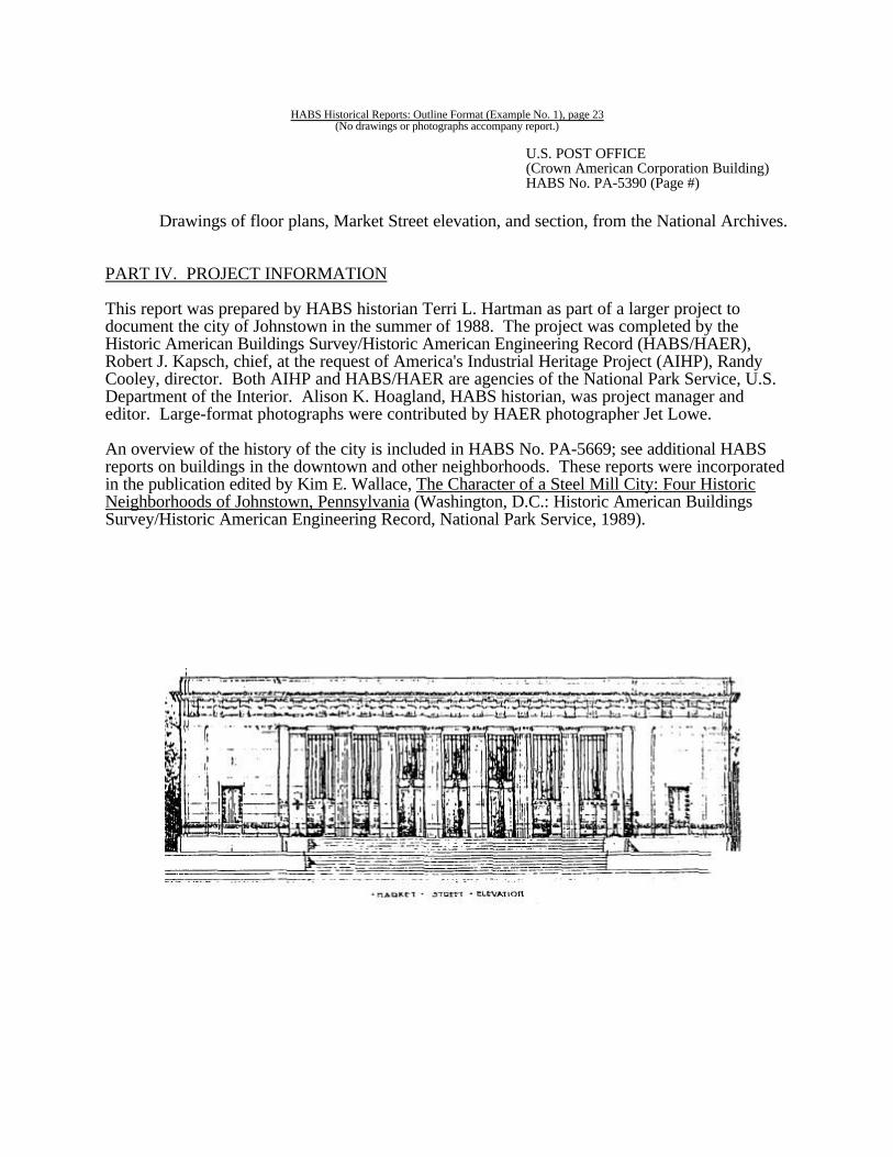
Drawings of floor plans, Market Street elevation, and section, from the National Archives.
PART IV. PROJECT INFORMATION
This report was prepared by HABS historian Terri L. Hartman as part of a larger project todocument the city of Johnstown in the summer of 1988. The project was completed by theHistoric American Buildings Survey/Historic American Engineering Record (HABS/HAER),Robert J. Kapsch, chief, at the request of America's Industrial Heritage Project (AIHP), RandyCooley, director. Both AIHP and HABS/HAER are agencies of the National Park Service, U.S.Department of the Interior. Alison K. Hoagland, HABS historian, was project manager and editor. Large-format photographs were contributed by HAER photographer Jet Lowe.
An overview of the history of the city is included in HABS No. PA-5669; see additional HABSreports on buildings in the downtown and other neighborhoods. These reports were incorporatedin the publication edited by Kim E. Wallace, The Character of a Steel Mill City: Four HistoricNeighborhoods of Johnstown, Pennsylvania (Washington, D.C.: Historic American BuildingsSurvey/Historic American Engineering Record, National Park Service, 1989).

HABS Historical Reports: Outline Format (Example No. 1), page 24(No drawings or photographs accompany report.)

HABS Historical Reports: Outline Format (Example No.2), page 25(Report is part of comprehensive HABS documentation.)
HISTORIC AMERICAN BUILDINGS SURVEY
CLIFTON FARM(Worthington Farm, Riverside Farm)
HABS NO. MD-1052
Location: Monocacy National Battlefield, approximately one mile off Baker ValleyRoad, driveway just south of the I-270 overpass, Frederick vicinity,Frederick County, Maryland.
The Clifton Farm sits atop a slight knoll, facing east, with gently rollingfields all around. The winding Monocacy River lies to the north and west. An approximately 1-mile-long dirt drive winds around from the southeast. There are no longer any outbuildings, but the fields are still planted.
Present Owner U. S. National Park Service (Monocacy National and Occupant: Battlefield)
Present Use: Awaiting restoration for use as interpretive site.
Significance: Built about 1851, Clifton is representative of a rural house type which wascommon among the substantial farmers in Frederick County and thesurrounding region during the first two thirds of the nineteenth century. The Battle of Monocacy (July 9, 1864), where the Confederacy won anominal victory, but Union commander Lew Wallace succeeded in delayingConfederate Jubal A. Early long enough to prevent the latter's seizure ofWashington, was fought on the Clifton farm and neighboring farms.
PART I. HISTORICAL INFORMATION
A. Physical History:
1. Date of erection: Ca. 1851. The first definite record of the house is from 1852,when the county assessment listed a "brick dwelling and barn" for the property. The farm "Clifton" was created by combining portions of neighboring tracts. Thenecessary lands had been united in the hands of wealthy farmer Griffin Taylor in1847. In 1851 Taylor sold Arcadia, his primary farm and the one on which stoodthe mansion in which he had resided up to that time.
For a year Clifton was the only farm owned by Taylor; then in 1852 he purchasedthe adjoining property, Araby, where he afterward resided. In combination withthe documentary evidence, several elements in the house's original constructionpoint to the 1850s as being the era in which it was built: circular-sawn studs, theuse of bridging to help support the floors, and the simplified carpentry of the roofsystem (reflecting modern abandonment of the mortise-and-tenon joint). Therafters are mitered and nailed together at the peak (without a ridge board), andtheir feet are nailed to the attic floor joists (with an intervening false plate). There

CLIFTON FARM(Worthington Farm, Riverside Farm)HABS No. MD-1052 (Page #)
HABS Historical Reports: Outline Format (Example No.2), page 26(Report is part of comprehensive HABS documentation.)
are no tie beams reinforcing the pairs of rafters. The fact that Taylor's finalpurchase of land for Clifton Farm in 1847 appears to have been made largely tosecure ground on which to make a lane from the Georgetown Pike to thefarmstead, however, raises the possibility that the house was built in that year.
2. Architect: Not known.
3. Original and subsequent owners: Reference is to the Land Records of FrederickCounty, Maryland, which fall under the supervision of the Frederick County CircuitCourt.
Clifton Farm was created ca. 1847-1851 by combining three tracts, totalling 300 acres,each of which had heretofore been part of a larger tract. The farmstead was sited at theintersection of the three pieces.
A: 121 acres, from "Arcadia"1835 Deed April 21, 1835, recorded in Liber JS 48, folios 522-524.
John McPherson, of Frederick County, trustee for the estate of John BrienToGriffin Taylor.(Griffin Taylor sold the remainder of Arcadia, 287 acres with a mansionlocated on the other side of the Monocacy, to Michael Keefer in 1851.)
B: 132 acres, from the John L. Harding Farm 1841 Deed September 25, 1841, recorded in Liber HS 14, folio 304.
James M. Harding, William J. Ross, and Madison Nelson, of Frederick County,trustees for the estate of John L. HardingToGriffin Taylor.(Griffin Taylor sold the remainder of the Harding Farm, 380 acres, to Daniel andEdward Baker in 1841.)
C: 47 acres, from "Araby"1847 Deed August 18, 1847, recorded in Liber WBT 5, folios 282-283.
William J. Ross, of Frederick County, trustee for John and Fanny McPhersonToGriffin Taylor.
1856 Deed April 2, 1856, recorded in Liber ES 8, folios 564-566.Godfrey Koontz and Michael Keefer, of Frederick County, trustees for the estateof Griffin TaylorToJohn F. Wheatley and T. Alfred Ball, of Georgetown, District of Columbia.
1862 Deed April 18, 1862, recorded in Liber BGF 7, folios 439-440. John F. Wheatley and wife Catharine, of Baltimore City, Maryland, and Turner A.
Ball and wife Elizabeth, of Washington City, District of ColumbiaToJohn T. Worthington.

CLIFTON FARM(Worthington Farm, Riverside Farm)HABS No. MD-1052 (Page #)
HABS Historical Reports: Outline Format (Example No.2), page 27(Report is part of comprehensive HABS documentation.)
1905 Will written and probated 1905, recorded in Liber WBC 1, folio 104.John T. WorthingtonToGlenn H. Worthington, of Frederick, and Clarke Worthington, of Staunton,Virginia (sons).
1931 Half-interest: Will written June 2, 1930, probated June 2, 1931, recorded inFrederick County Wills, Liber RLL 2, folio 204.Clarke Worthington, of Staunton, VirginiaTo Augusta National Bank, of Staunton, Virginia (as trustee).
1951 Half-interest: Deed December 24, 1945, recorded in Liber 496, folio 387-388.Augusta National Bank (as trustee)ToMary Ruth Pfeil, Richard A. Worthington, Julie H. Martin, Dorothy W. Reed, andJohn C. Worthington, the heirs of Glenn H. Worthington.
1934 Half-interest: Will written May 16, 1933, probated August 20, 1934, recorded inLiber MFS 1, folio 404.Glenn H. Worthington, of FrederickToHis children.
1953 Deed July 8, 1953, recorded in Liber 522, folio 21.Mary Ruth Pfeil and husband Robert H., of Frederick County, Richard A.Worthington and wife Ruth S., of Polk County, Iowa, Julia H. Martin and husbandLorenzo W., of Washington, D. C., Dorothy W. Reed and husband Paul H., ofWashington, D. C., and John C. Worthington and wife Nina Brown, of DeKalbCounty, GeorgiaToJenkins Brothers, Incorporated.
1971 Deed March 30, 1971, recorded in Liber 843, folios 739-740.Jenkins Brothers, Inc., of Frederick CountyToJenkins Foods Corp.
1982 Deed March 26, 1982, recorded in Liber 1169, folios 933-941.Jenkins Foods Corporation of FrederickToUnited States of America (National Park Service).
4. Original plans and construction: The house has an L-shaped plan, with a main blockbuilt in a two-story, center-passage, single-pile configuration, and a two-story, one-roomell projecting from the main block's rear. Both sections are original. The house was builtwith two porches, one across the full width of the facade, and a small one on the rear ofthe main block at the juncture of the two sections. The house faces east.

CLIFTON FARM(Worthington Farm, Riverside Farm)HABS No. MD-1052 (Page #)
HABS Historical Reports: Outline Format (Example No.2), page 28(Report is part of comprehensive HABS documentation.)
5. Alterations and additions: The house has never received a major or permanentstructural addition. There have been a number of alterations, however.
Ca. 1856-1857, during the period in which the house was the joint property of T. A. Balland John F. Wheatley, the owners undertook to upgrade the house's appearance from thatof a superior class of tenant farmhouse to that of the dwelling of a prosperous freeholder. They transformed the interior finish of the center stair passage and the two south rooms ofthe main block, replastering the walls, replacing the window, doorway and baseboard trim,and hiring painters to create trompe l'oeil ornamentation (this latter work in the stairpassage and in the first-floor room only). In addition, graining was applied to the doors inthe main block. The north room on the second floor of the main block may also havebeen fitted with its built-in floor-to-ceiling cupboard.
Less evidence presents itself for dating subsequent alterations. The woodwork of thefront doorway suggests that it was rebuilt in the 1870s, though the size of the dooraperture in the masonry was not changed. John T. Worthington's widowed cousin LaviniaWorthington ran the house as a boardinghouse ca. 1895-1905. It was possibly in thisperiod that the kitchen was shifted from the cellar of the ell to its first floor, with theinstallation of a cookstove to complete this change in room use. The running of a waterpipe into the first floor of the ell (the house's only concession to indoor plumbing), and thelaying of an additional layer of narrow floorboards in that room and in the adjoining(north) room of the main block, may also have been elements of the change in kitchenarrangements.
Later changes to the house included the installation of electric lighting, probably ca. 1935when the same was done at the neighboring Gambrill House. Sometime after JenkinsBrothers, Inc., purchased Clifton from the Worthington family in 1953, the kitchen wasupdated with a modern gas-fueled cooking range and linoleum floor covering. It was alsosometime following 1953 that several rooms received partitions (now removed by theNational Park Service) to better enable the house's employment as a barracks for migrantfarmworkers. Many changes have been made over the years in the house's heatingarrangements (see mechanical systems, Part II. 8.).
The space in the main-block cellar beneath the center passage and the south room hasbeen changed twice over the past century or so. It was originally two roomscorresponding to those above. At some point the cellar's south room was divided intothree spaces (a passage and two rooms). Later these partitions were removed, as well theoriginal one between the south room and that under the center passage, leaving the areaone large space.
B. Historical Context
1. The house and its occupants:
The Clifton Farm House was built sometime from 1847 to 1852, most likely inthe year 1851.On the county assessment of 1852 it appeared as one of two houses,both built of brick, owned by wealthy agriculturist Griffin Taylor.

CLIFTON FARM(Worthington Farm, Riverside Farm)HABS No. MD-1052 (Page #)
HABS Historical Reports: Outline Format (Example No.2), page 29(Report is part of comprehensive HABS documentation.)
Taylor's other brick house in 1852 was Araby, his own residence. Taylor had justthat year purchased Araby Farm, which adjoined Clifton Farm to the east. Taylor's abode from 1835 to 1851 had been Arcadia (listed on the NationalRegister in 1991), located just across the Monocacy River. He had moved to thevicinity from Virginia. Both Arcadia and Araby had probably been built (orbegun) around the close of the eighteenth century, and both were two-story,center-passage, double-pile brick houses with smaller attached structures. OfClifton's 300 acres, 121 acres had originally been part of Arcadia. Access acrossthe river was had by means of a ford, which would prove instrumental in theConfederate victory in the Battle of the Monocacy (fought on this and neighboringfarms on July 9, 1864).
The Clifton Farm House is a two-story, center-passage, single-pile house, with ell,constructed of brick. Griffin Taylor's intentions for this structure, a modest one incomparison to the Georgian plantation houses in which he lived before 1851 andafter 1852, are not clear. It appears most likely that he built the house to be hisown temporary residence (between mansions), and afterwards to serve as thehome of a farm manager and perhaps eventually of a married child. Araby, whichTaylor purchased in 1852, had gone unoccupied by an owner since 1848, due to aprotracted settlement process attending the death of the previous owner, IsaacBaugher. Apparently Taylor had had his eye on Araby when he sold Arcadia in1852.
Taylor built the Clifton House in the manner of a tenant house of a superior classof soundness, comfort and finish. The original woodwork, found in the northrooms on both floors of the main block, is of a respectable but not elegantcharacter. Similar tenant houses of a higher grade were built by wealthylandowners during this period in other parts of the Mid-Atlantic region, such ascentral Delaware. Griffin Taylor died in 1855, aged just fifty-one. An 1856advertisement in the Frederick Examiner for Taylor's real estate made explicit therelationship between the Araby and Clifton farmsteads, that the former was theprincipal on the estate and the latter a subsidiary.
FIRST.--THAT BEAUTIFUL AND PRODUCTIVE
FARM
called "Araby," CONTAINING
261 acres of Land,
more or less. This farm was the residence of the late deceased, and is one of themost desirable in the county. It lies three miles South of Frederick, on theGeorgetown road and within half a mile of the Baltimore and Ohio Railroad, andin sight of a large Flouring Mill. The improvements are of the best order,consisting of a large TWO-STORY BRICK
MANSION HOUSE,
CLIFTON FARM(Worthington Farm, Riverside Farm)HABS No. MD-1052 (Page #)
HABS Historical Reports: Outline Format (Example No.2), page 30(Report is part of comprehensive HABS documentation.)
with Back Building, suitable for a large family; a stone Tenant HOUSE,Blacksmith Shop, a large Switzer Barn, Corn Crib, Smoke House, Ice House, withall other suitable necessary out-buildings; running water in nearly every field, and aPump and running fountain in the Barn yard. . . . There is also a large
APPLE ORCHARD,on the premises.
2nd.-- The Farm,
adjoining Araby, called "Clifton,"
CONTAINING 300 ACRES
more or less; 280 acres are in a high state of cultivation, the residue in Timber, andis acknowledged to be one of the most productive Farms in Frederick County. There is running water in every field. The improvements consist of a new TWO-STORY BRICK
HOUSEAND KITCHEN, a good Frame Barn, and a Corn Crib, sufficiently large
to house four hundred barrels of Corn; with a large numberof
FRUIT TREESaround the dwelling. . . .
The purchasers of Clifton and Araby in 1856 were two partners fromGeorgetown, T. A. Ball and John F. Wheatley. The link between Clifton andAraby continued for most of their ownership, until 1860. In 1857 the Ball andWheatley partnership formed a consortium with neighboring miller James H.Gambrill to operate a distillery which they built at Gambrill's "Araby Mills." It islikely that the three men had actually come up with this idea in 1856, when Arabyand Clifton were on the market. Gambrill had purchased the mills as recently as1855, and is said to have immediately embarked on ambitious renovations. Hewas no doubt open to new ventures for the mill. The firm was known as"Wheatley and Gambrill"; Ball farmed Clifton and Araby to raise the necessarygrain (rye or barley), Gambrill ground it into malt, and Wheatley ran the distillery. The timing was not right to begin this seemingly cost-efficient operation, however. An economic recession set in in 1857 which continued until the onset of the CivilWar (1861). The distillery failed in 1860. Ball and Wheatley sold Araby Farm toC. K. Thomas, and Wheatley moved away. Ball, evidently the partner whoresided in the Clifton house, stayed on for a time.
Turner Alfred Ball's relatively brief (six years) occupancy of the Clifton FarmHouse left a profound decorative legacy. Ca. 1856-1857 Ball apparently soughtto upgrade the feel of the house from that of the better-than-average dwelling fora tenant farmer to that a prosperous agriculturist's mansion. He applied new trimto the center stair passage and the south rooms of the main block, on both the firstand second floors, and he had that first-floor room and the passage embellishedwith an elaborate trompe l'oeil paint scheme.

CLIFTON FARM(Worthington Farm, Riverside Farm)HABS No. MD-1052 (Page #)
HABS Historical Reports: Outline Format (Example No.2), page 31(Report is part of comprehensive HABS documentation.)
The painter who executed the work was almost certainly Constantine Brumidi, theItalian immigrant who created the frescoes which grace the U.S. Capitol inWashington, during the mid-to-late 1850s. Brumidi is known to have carried outa number of commissions to decorate the interiors of private homes in the regionduring the period he was working in the Capitol. The artist is thought to haveapplied his craft to at least eight Frederick County houses (aside from the CliftonFarm House), as related in an undated essay written by a staff member of theFrederick County Landmarks Foundation. Only two of these eight, an 1856farmhouse in southern Frederick County called "Saleaudo," and 101 East ChurchStreet in Frederick, are known to have survived to 1991. The paintwork in thesetwo houses is dated as ca. 1856-1858 and 1857, respectively. The work atSaleaudo and that at the Clifton Farm House appear so similar as to suggest thatthey must have been done by the same man. Consultation with experts in the fieldmight confirm this identification. T. A. Ball, who moved from Georgetown toFrederick County in 1856, may even have been instrumental in introducingBrumidi to the county. The trompe l'oeil paintwork at the Clifton Farm Houseconsists of gray faux panelling with dark red borders on the walls and ceilings(including that of the center passage), with a white ceiling medallion (somewhatdiscolored in 1991).
Ball and Wheatley sold Clifton Farm to John T. Worthington in 1862. Born in1826 into an extended Frederick County family of "prominent" well-off farmers,Worthington wed Mary Ruth Delilah Simmons (born ca. 1832), also of"prominent" local lineage, in 1856. John and Mary Worthington spent the rest oftheir lives at Clifton, Mary dying in 1902, John in 1905. They renamed the place"Riverside Farm." John was a lifelong farmer until physical disability dictated hisretirement, sometime in the 1890s. He was evidently a successful agriculturist,managing to acquire an additional farm as well as to hold onto and improveClifton. The Worthingtons also maintained a townhouse in Frederick until the1890s, at 37 West Third Street (no longer an active address in 1991), which Johnhad evidently inherited from his father, James W. Worthington.
The Clifton Farm House is an exemplary architectural embodiment of the mode oflife of the comparatively well-off farmer of the region in the mid-nineteenthcentury. One aspect of the lower Mid-Atlantic's vernacular domestic architectureduring this era was the separation of a house's service space from the polite livingspace inhabited by the master and his family. In the Clifton House this tendency isillustrated by the elegant stairway located in the center passage of the main block. This stairway connects only the first and second floors. The sole access to cellaror garret is by the ell's stairs. It appears that prior to ca. 1895 cooking was donein the cellar room of the ell and in a kitchen building separate from the house. John T. Worthington's great-grandson David Reed identifies the south room onthe first floor of the main block as the "parlor" or "best room," and the roomacross the passage and next to the ell on the same floor (the north room) as thehouse's "dining room," as of the 1930s. He believes that this had always been thepattern of these two rooms' use. The parlor, where well-regarded guests wouldhave been entertained and special family occasions celebrated, was thus as farremoved from the service spaces as possible. Reed is in possession of some of thehouse's furnishings from during John T. Worthington's occupancy, which are of

CLIFTON FARM(Worthington Farm, Riverside Farm)HABS No. MD-1052 (Page #)
HABS Historical Reports: Outline Format (Example No.2), page 32(Report is part of comprehensive HABS documentation.)
elegant character.
The first-floor ell room, which adjoins the dining room, was not at first thelocation of the house's kitchen. There were two fireplaces in the cellar ofadequate size for cooking, one in the ell and one at the south end of the mainblock, as well as a separate kitchen building (evidently a one-and-a-half-story one-room structure). The two cellar spaces with fireplaces differ in that the interior ofthe south room in the main block (which by 1991 had lost its north party wall) wascompletely plastered, while that of the ell cellar had only had its stone foundationwall plastered. It is likely that the hearth in the cellar of the ell was used forcooking during the cooler part of the year, while that at the other end of the housewas employed for laundering, or dairying, or rendering, or more than one of thesefarmstead activities. The room on the first floor of the ell may have served as anoffice and "mud room" for the farmer prior to being made into the primarykitchen. Its first-period interior woodwork is of a level of finish not so fine as thefirst-period woodwork of the first floor of the main block, but finer than that ofthe second floor. A fireplace not of adequate size for cooking was the originalsource of heat in this room.
At some point in the 1890s, as the aging John T. Worthington's health declined,the manner in which Clifton functioned as a residence changed drastically. It wentfrom a substantial farmer's manse to a boardinghouse. Worthington ceasedfarming, and his widowed cousin-by-marriage Lavinia Worthington (born ca.1848) and Lavinia's widowed sister-in-law Loyd Dorsey (born ca. 1836) movedinto Clifton to care for him and Mary. Of the Worthingtons' three living children(all sons), Glenn was a lawyer resident in the town of Frederick, and John Henryand Clarke were merchants in Staunton, Virginia. The 1900 census recordsLavinia as head of household, though John and Mary Worthington remained inresidence, noting Lavinia's occupation as "keeping boarders." It appears likelythat it was in this boardinghouse period that the primary location of the kitchenwas changed to the first floor of the ell, which likely involved fitting that spacewith a cookstove.
John T. Worthington died in 1905 (Mary having preceded him by three years), andClifton Farm descended to Glenn and Clarke Worthington as co-owners. Neitherbrother took up residence there. Instead the farm was rented to tenant farmers. According to David Reed, three generations of the same family were tenants at theClifton Farm from 1905 to 1953. Few changes were made to the house duringthis period; electric lighting was introduced but not central heating or indoorplumbing (beyond one pipe to bring water to the kitchen).
In 1953 the Worthington family sold the property to Jenkins Brothers, Inc., acorporate farming operation owned by another Frederick family. The Jenkinsfamily's ownership of Clifton lasted until 1982, at which time the property wasacquired by the National Park Service. During the Jenkins period the house wasemployed as a virtual barracks for migratory farmworkers.
2. Farming in the Monocacy Valley:
CLIFTON FARM(Worthington Farm, Riverside Farm)HABS No. MD-1052 (Page #)
HABS Historical Reports: Outline Format (Example No.2), page 33(Report is part of comprehensive HABS documentation.)
Although the primary-source research undertaken for this project made littleexamination of the years before ca. 1790, secondary sources indicate that thevicinity of the Clifton and Gambrill farms had been occupied by settlers, and theland first claimed, in the 1730s or 1740s. This area was part of the fertile,limestone-based formation known as the Frederick Valley or Monocacy Valley, awide belt of bottomland which follows the course of the Monocacy River throughFrederick County. The Frederick Valley was the first region of the county to besettled, and as such was occupied from one end to the other within a couple ofdecades. The town of Frederick was laid out just three miles to the north of theAraby area in 1745; this young town became the seat of the new county ofFrederick in 1748.
The first meeting of the Frederick County Court, in 1749, reviewed and certifiedthe ferry licenses that fell within its purview. Among the county's four ferries(three of which crossed the Monocacy) was one in the Araby area, that over theMiddle Ford on Monocacy, operated by Daniel Ballenger. This ferry operatedinto the early 1800s, when it was superseded by a wooden bridge in the samelocation as the modern one which carries Route 355 over the river. (The point onthe river at which the ferry crossed is a stone's throw downriver from the bridge,however.) The existence of this ferry in 1749 implies that the road from the townof Frederick to Georgetown (Rt. 355 in 1991) was also there at the time, and thatit was one of the county's major roads, as it would continue to be until the creationof Interstate 270. The combination of excellent soil, proximity to town, access toa major transportation route, and waterpower potential (which would be fullyrealized by the nearby mill, owned and operated by James H. Gambrill) made theAraby neighborhood a prime location.
The general mode for settlers' acquisition of land in the Frederick Valley in the1730s and 1740s was not for the homesteaders themselves to claim the land fromthe provincial land office. As historian Elizabeth Kessel relates, most of the landin the valley was claimed by various well-positioned and -financed residents of theTidewater region of Maryland, who always seemed to be in step with, or a stepahead of, the actual settlers. The latter chose good homestead sites and squatted,and were generally able to arrange relatively easy terms of purchase with theowning grandees.
Evidently, from an early date the situation in the Araby neighborhood divergedfrom this mode, in that the ownership of a large amount of land remainedconcentrated in a few wealthy hands. The overall Monocacy Battlefield area (i.e.,the Gambrill, Clifton, Thomas, Daniel Baker, Edward Baker, Best, Markel andMcGill properties in 1864) was divided between just two owners until 1801. Thissituation, and its long persistence, was probably due to the neighborhood's highdesirability as a location, as discussed above. It was not until 1795 that bothowners were residents, though one was from 1759 onward. No research has beendone on the non-owning inhabitants who were no doubt occupying theserespective tracts prior to the 1759 and 1795 purchases.
Subsequent divisions of properties increased the number of owners in the area tofour in 1806, which was the number until 1841. Prior to the latter year the Araby

CLIFTON FARM(Worthington Farm, Riverside Farm)HABS No. MD-1052 (Page #)
HABS Historical Reports: Outline Format (Example No.2), page 34(Report is part of comprehensive HABS documentation.)
vicinity, as it was by then called (after one of the estates), seems to have beenthoroughly a neighborhood of wealthy agriculturists. In the 1835 FrederickCounty assessment the smallest of the four properties was recorded as 616 acresin extent, about four times the size of a more typical farm in the county, the largestas 1,111 acres. Two or three of the owners generally had their primary or onlyresidence on their Araby farms at any given time. Divisions of property whichoccurred between 1841 and 1860 increased the number of owners in the Arabyneighborhood to eight.
The area's character had become somewhat less that of an enclave of the rural eliteby 1864, but only somewhat. Arcadia (McGill's) and Araby (Thomas's) remainedrich agriculturists' seats, Araby Mills prospered greatly under James H. Gambrill'sownership, and two other properties (Best's and Markel's) were tenancies ownedby wealthy town families. It would be more accurate to suggest that the farms ofJohn T. Worthington and the Baker brothers, Daniel and Edward, represented anintrusion of the substantial-but-not-wealthy middling class of farmer, than it wouldbe to posit a democratization of the neighborhood.
As of the Battle of the Monocacy (July 9, 1864), the farmstead on the CliftonFarm was probably not an extensively developed one. This was despite the factthat the property's land had long been farmed. An 1856 advertisement for theproperty printed in the Frederick Examiner noted that the farm possessed 280acres improved and 20 acres woods, the high proportion of improved suggestingthat people had been at work clearing the farm's land for several generations. Asan independent farmstead this one was relatively new, however, having only beencobbled together by wealthy agriculturist Griffin Taylor from parts of three olderproperties ca. 1847-1851. From 1852 to 1860 "Clifton" (as the farm had beennamed at its creation) had been a subsidiary one to the much older Araby (orThomas's; probably started by 1760), the two adjoining properties comprising onelarge agricultural estate. The 1856 advertisement had described the Cliftonfarmstead complex as consisting
of a new two-story brick house and kitchen [evidently separate buildings],a good frame barn, and a corn crib, sufficiently large to house four hundredbarrels of corn, with a large number of fruit trees around the dwelling.
The primary farmstead Araby, on the other hand, featured
a blacksmith shop, a large switzer barn, corn crib, smokehouse, ice house,with all other suitable necessary out-buildings; . . . also a large appleorchard,
as well as Araby mansion and a "stone tenant house."
At the time of the battle the Clifton Farm was probably much the same asdescribed in the above advertisement. From 1856 until it was purchased by JohnT. Worthington in 1862, it was owned by partners T. A. Ball and John F.

CLIFTON FARM(Worthington Farm, Riverside Farm)HABS No. MD-1052 (Page #)
HABS Historical Reports: Outline Format (Example No.2), page 35(Report is part of comprehensive HABS documentation.)
Wheatley. For four of those six years, or until Ball and Wheatley sold Arabyseparately to C. K. Thomas in 1860, the Clifton Farm continued to be a subsidiaryfarmstead to Araby. Aside from their ownership of the two farms, from 1857 to1860 Ball and Wheatley were partners with neighbor James H. Gambrill in adistillery located at Gambrill's Araby Mills. Ball raised the grain (rye or barley),Gambrill ground it to make malt, and Wheatley distilled the whisky. The distilleryfailed in 1860, Ball and Wheatley sold Araby while retaining Clifton, and Wheatleymoved to Baltimore. The Clifton Farm house was evidently the residence of T. A.Ball.
In his 1932 account of the Battle of the Monocacy, Worthington's son Glennnoted the existence in 1864 of a "quarter" standing near the south end of thehouse. This was the one known addition to the farmstead made by 1864, by eitherBall or Worthington. A photograph of the farmstead taken ca. 1930, in thecollection of David Reed, shows a one-and-half-story building with a centerchimney in the location indicated by Glenn Worthington. It was similar to slavehouses built in the Chesapeake region during the nineteenth century, and probablyhad a two-room-long, one-room-deep plan.
Worthington had owned seven blacks in 1860 (at which time he was a tenantfarmer on a different farm), and retained "a few" in 1864, according to his sonGlenn. By the latter's account, the thirty-eight-year-old, middling-level farmer hadinherited the slaves, and the blacks had remained patient and loyal during the war. The Emancipation Proclamation of 1863, after all, had only freed slaves resident inthe then unconquered (and still extensive) portions of the Confederacy. The twoslaves known to have been present in 1864 were John Ephraim Tyler Butler andThomas Palm. Disregarding the inherent injustice of slavery, Worthington neededlabor from outside his nuclear family, whether unfree or paid. His and wife Mary'stwo children, John and Glenn, were but 7 and 6 years old. Only one ofWorthington's neighbors, C. K. Thomas, is known to have owned a slave in 1864(a 14-year-old boy named Horace). The number of free, paid farm laborerspresent in the neighborhood at that date, when both armies had enlisted theirshares of Maryland's young manhood, is unknown.
Agricultural census records (see figures #1 & #2) suggest that in 1864 John T.Worthington was pursuing the same form of husbandry practiced by all of hisAraby fellows in the years just before and after the war. The neighborhoodagriculture emphasized the raising of a certain few commodities for regionalmarkets, with a variety of other products grown for subsistence. The marketcommodities, raised on all or nearly all neighborhood farms, comprised butter,hay, slaughtered livestock (for meat and leather), and most important, wheat. Inthis mixture of profitable agricultural goods Araby was representative of FrederickCounty's more fertile valley areas. Products grown by all Araby farms in modestquantities, evidently for home consumption, included oats, potatoes, gardenvegetables, apples and peaches. All farms raised large crops of Indian corn, butthis was probably used primarily as animal feed. Some farmers produced tobacco,rye, wool, honey or clover seed, or raised enough apples and peaches to takesome to market, but these were almost always secondary activities. Worthingtonfavored none of these latter in 1870.

CLIFTON FARM(Worthington Farm, Riverside Farm)HABS No. MD-1052 (Page #)
HABS Historical Reports: Outline Format (Example No.2), page 36(Report is part of comprehensive HABS documentation.)
Winter wheat, sown in September and harvested in early July, was the mostimportant market crop. This had been so since the first farms of the FrederickValley had passed their pioneer stage in the mid-eighteenth century, and FrederickCounty farms had joined those of other wheat-growing areas of the Mid-Atlanticregion in feeding a large portion of the Atlantic world. Around 1820 thedestination for the county's wheat had begun to shift from the international marketto the rising cities of Washington and Baltimore, a trend which had acceleratedsince 1840. Between that year and 1860 both cities more than doubled theirrespective populations. A decade or so after 1864 another great shift in theregional wheat trade would get underway, with spring wheat grown in the UpperMidwest combining with the nation's fast growing rail network to gradually driveMaryland's farms and mills out of the bread-wheat industry.
To John T. Worthington in 1864 winter wheat was still the greatest focus for hisagrarian energies. His son Glenn's account of the battle describes the frantic (anduncompleted) efforts undertaken by Worthington, C. K. Thomas and their helpersto gather in the reaped wheat on their respective farms on the morning of thebattle (July 9th). Jubal Early and his Confederate Army of the Valley arrived inthe vicinity just at harvest time. Later in the day stacks of wheat, which Thomashad not been able to take in, turned the initial charge made by the right wing ofConfederate John B. Gordon's division into confusion, as the advancing soldierswere forced to break ranks. For a time Confederate and Union troops chargedand countercharged amidst a host of burning wheat stacks.
Another factor which influenced agriculture on Frederick Valley farms in thecourse of the years from 1820 to 1864, beside those of the demise of foreigndemand for wheat and the growth of Washington and Baltimore, was that of thegreat improvement in the region's means of transportation. With a much improvedroad system, which included the Georgetown Pike, and the Baltimore and OhioRailroad (opened in 1831), the great demand in the rising cities enabled butter,meat and hay to take much of the edge off of wheat's preeminence among theFrederick Valley's market crops. By 1864 Araby neighborhood farms, presumablyincluding that of John and Mary Worthington, were sending considerablequantities of these goods to the cities. Araby's residents had particularly easyaccess to the Georgetown Pike and to the B & O, since both passed directlythrough the neighborhood. Census figures suggest that the belt of farmlandimmediately encircling Frederick, including the Araby neighborhood, became aparticular hub of dairy activity.
According to local historians writing in the late 1800s and early 1900s, FrederickCounty had been noted for its fine pasturage, and had been something of a centerfor livestock raising from its early years. The number of tanneries reported for thecounty in the 1820 census of manufactures, thirty-seven, is an impressive one atthat early date. There were forty-three in 1850, though the number of tanneriesdecreased to twenty-one in 1870. This numerical decline was possibly the resultof an increase in the scale of the typical tannery's business, with a related trendtoward centralization. At any rate the hides of slaughtered animals no doubtrepresented a significant commodity to Araby farmers.

CLIFTON FARM(Worthington Farm, Riverside Farm)HABS No. MD-1052 (Page #)
HABS Historical Reports: Outline Format (Example No.2), page 37(Report is part of comprehensive HABS documentation.)
John Worthington saw to the wheat, the hay (horses lived in cities as well aspeople), the beef and pork, and the hides, but the butter would have been MaryWorthington's responsibility. Dairying was woman's work on American farms in1864, as it had been in Western society for centuries. In recent years historianshave speculated that the mid-nineteenth century's intensified growth in the scale ofdairy work on those northeastern farms with access to urban markets gave many afarm woman a greater role in the management of her family's farm and itshousehold economy.
The middle decades of the nineteenth century comprised an era of great innovationin American agricultural technology. Of particular note was the introduction of aplethora of labor-saving mechanical devices, such as horse-drawn or -poweredmachines for reaping, hay-turning, threshing and cultivating, handcranked butterchurns, and seed drills. The whole range of traditional farming tools (plows,harrows, scythes, etc.) was improved as well.
There is little evidence as to John T. Worthington's farming methods or tools in1864. It is likely, however, that the presence of his slaves and a lack of otherassets led him to pursue a relatively traditional, labor-intensive approach, with agang of workers wielding cradle scythes to cut the mature wheat instead of twomen tending one of Cyrus McCormick's horse-drawn reapers. The countyassessment of 1866 noted no valuation for "farming implements" in its appraisal ofWorthington's taxable estate, though three of his neighbors had such assetsrecorded. The 1870 agricultural census and the 1876 county assessment did makesizable valuations for implements at Worthington's, as with all his farmingneighbors. The Civil War's drain on northern farm manpower and the strongwartime market for farm commodities impelled a rapid diffusion of the newmachinery among middling Northern farmers. (Prior to the war the improvedtechnology had largely been the province of wealthy "agriculturists.") But theavailability of Worthington's slaves in 1864 probably obviated his need to followthis trend.
3. The Battle of Monocacy:
The Battle of Monocacy was fought on July 9, 1864, on the banks of theMonocacy River three miles to the southeast of Frederick, Maryland. Nominally aConfederate tactical victory, "The Battle that Saved Washington" was fought byUnion forces as a delaying action, and ultimately proved a strategic success for theUnion cause.
The fight at the Monocacy came about as part of the sequence of events triggeredby a diversionary campaign planned by Robert E. Lee and executed byConfederate Lieutenant General Jubal A. Early. The Confederate generalsintended to derail Ulysses S. Grant's strategy for attaining a decisive Union victoryby forcing Grant to abandon his siege of Petersburg and pull the Army of thePotomac back to northern Virginia, or even Maryland, in order to secureWashington. Lee knew that Grant had stripped the Washington garrison to thebone to enlarge his army for the all-out advance down eastern Virginia. This putthe national capital with its government offices, navy yard and storehouses of
CLIFTON FARM(Worthington Farm, Riverside Farm)HABS No. MD-1052 (Page #)
HABS Historical Reports: Outline Format (Example No.2), page 38(Report is part of comprehensive HABS documentation.)
munitions and supplies, and its tremendous symbolic and psychologicalimportance, in a potentially precarious position. Early, commander of the Army ofthe Valley, swept the Shenandoah Valley of Union forces and invaded Maryland,crossing the Potomac River with fifteen thousand or so troops near Harpers Ferryon July 5-6.
Early's opponent at Monocacy was Union Major General Lew Wallace,commander of the Middle Department (headquartered in Baltimore). The latterpost was a regional rear-echelon administrative district. Wallace took the field ascommander, an unauthorized move, because the War Office in Washingtonwillfully refused to acknowledge Early's threat until it was almost too late. TheConfederate general had done a masterful job of screening his advance. Informedby the Baltimore and Ohio Railroad that the company's agents at ShenandoahValley depots reported a major Confederate move, numbers unknown, Wallacescraped together odds and ends of Union garrison troops, trainees, and localmilitia, counting in all some 2,300 men. He rushed these troops to the strategiclocation where he planned to give battle, and where the armies would indeedclash, arriving himself to supervise preparations on July 5. This place had longbeen known to local inhabitants as Araby, the name of a large estate which in theearly 1800s had encompassed a large part of the vicinity. More recently the nameFrederick Junction had been applied, since just on the west side of the Monocacythe through line of the B & O, going from Baltimore to Harpers Ferry, was joinedto the three-mile spur line serving the town of Frederick.
Lew Wallace had three motives in pitting his small and unseasoned force againstthe advancing foe: to determine Early's strength, to determine the latter's objective(which could plausibly have been Baltimore instead of Washington), and to buytime for the sending of substantial Union forces, which Wallace did not know ofbut prayed were being sent from the main army in Petersburg. Defeat seemed acertainty to the Union commander, but he sensed that he and his men had beenthrust into a role from which they must not retreat.
Fortunately for the Union, General Grant was also receiving vague but troublingreports from the Shenandoah. Though assured by the War Office that nothingmore was on than rebel raiding activity, Grant decided on July 5 to send the SixthCorps, composed of veteran fighters, by ship to ensure the capital's defense. Hehurried ahead the corps' Third Division, commanded by Brigadier General JamesB. Ricketts. On July 8, Ricketts brought two of the division's brigades, some3,500 troops, by rail to join Wallace at Araby.
In the meantime, July 7, Wallace had advanced some of his troops into the hillcountry to the west of Frederick to skirmish with the Confederate advance guard,in an unsuccessful effort to discern the size of the overall Confederate army. Skirmishing continued between Union troops and Early's cavalry on the levelcountry just beyond Frederick's western outskirts during July 8. That evening, stillunsure of the strength of the main Confederate force, Wallace withdrew hisforward troops to the chosen defensive position on the east bank of theMonocacy.

CLIFTON FARM(Worthington Farm, Riverside Farm)HABS No. MD-1052 (Page #)
HABS Historical Reports: Outline Format (Example No.2), page 39(Report is part of comprehensive HABS documentation.)
Wallace's selection of ground on which to make his stand was far from arbitrary. Nor was Araby unknown turf to the officers and men of the opposing armies. Thetown of Frederick had developed into a major road junction. It would be littleexaggeration to say that all roads in the western half of Maryland led there. Below the greater Frederick region the Potomac River was unfordable. Onceacross, if it sought to employ roads substantial enough to permit rapid passage, aneastward bound invading army would have to pass through Frederick. From theFrederick crossroads The Baltimore Pike (US Rt. 40 in 1991) ran east, and theGeorgetown Pike (Rt. 355) southeast (toward Washington).
Due to Frederick's central location, the town, and Araby, had seen blue and grayuniforms before. The proposed boundaries of the Monocacy National Battlefield,in fact, encompass the sites of several Civil War events not directly related to the1864 battle. The main Confederate and Union armies both camped at Arabywithin a few days of each other during the week-and-a-half prior to the Battle ofAntietam, in September 1862. It was in the Best Farm woodlot, just across theGeorgetown Pike from the Best farmstead itself, that Lee and his generals held acouncil of war on September 8, 1862. In a now famous blunder, a Confederateofficer left a copy of the campaign plan resulting from the meeting on this ground,wrapped around three cigars. Five days later Union troops setting up camp found"The Lost Order," which set in motion Lee's near-entrapment at Antietam. TheArmy of the Potomac camped at Araby again in late June 1863, just before theBattle of Gettysburg. In early August 1864 Union generals Grant and Sheridanheld a meeting at Araby House (the Thomas Farm mansion) to plan Sheridan'scampaign in the Shenandoah Valley campaign.
Wallace's dispositions of July 9, 1864, were designed to block Early's progressalong either of the two main eastward pikes by arranging his troops in a line alongthe east bank of the Monocacy from just north of the Baltimore Pike bridge to justsouth of the Georgetown Pike bridge, a distance of two-and-a-half miles. The B& O Railroad bridge was just a few hundred yards upriver from the GeorgetownPike bridge. Wallace concentrated his forces at the bridges, with Ricketts'sveterans at the Georgetown Pike, the more likely Confederate advance route. Thepossibility of enemy fording of the Monocacy between the two bridgesnecessitated the manning at thin strength of the entire line, however. This Unionposition ensured Wallace of the attainment of his limited goals. The defensivevalue of the Monocacy's east bank was enhanced by the steepness of its slope forthe whole extent of Wallace's line, particularly near its south end, where the bankrises steeply, at some points fifty or sixty feet above the river. There were alsoalready manmade defenses in this vicinity. The need to protect the railroad bridgeover the Monocacy from raid or sabotage had led to the creation of twoblockhouses, one on each side of the river, and of rifle pits on an overlooking bluffon the east bank just north of the track. This post was manned on a permanentbasis by about a hundred militia.
There was an Achilles' heel in Wallace's position, one recognized by Wallacehimself. This was a ford through the Monocacy, referred to by historians of thebattle as the Worthington-McKinney Ford. The ford lay three-quarters of a miledownriver from the south end of the Union line, and could be used by Early to

CLIFTON FARM(Worthington Farm, Riverside Farm)HABS No. MD-1052 (Page #)
HABS Historical Reports: Outline Format (Example No.2), page 40(Report is part of comprehensive HABS documentation.)
outflank Wallace. Here the banks were not steep but rose very gradually, andadvance from the ford could be swift. Wallace posted three troops of cavalry(probably about seventy men) to guard the ford. He did not extend his main lineto cover it because of the chance that Early's destination was Baltimore, theshortage of Union troops, and the fact that Wallace's object was mere delay. Thatthe Confederates would carry the day was a foregone conclusion.
The Worthington-McKinney Ford proved to be the route the Confederates took totactical victory. Desultory dueling between Confederate and Union took place atboth bridge vicinities throughout the day. Some of the battle's hardest (anddeadliest) fighting was done by 200 or so Union skirmishers assigned to hold therailroad junction area on the west side of the river for as long as possible. Themain action of the battle, however, was that between Confederate forces whichcrossed the river at the Worthington-McKinney Ford (Brigadier General JohnMcCausland's cavalry brigade followed by Major General John B. Gordon'sinfantry division), about 3,500-4,000 troops, and Ricketts's division of 3,000-3,500, which turned to meet them.
Early did take advantage of the ford, but his was a less than perfect flankingmaneuver. Cavalry general McCausland had found the ford, with the pressedassistance of a local farmer, and led his men across, on his own initiative. Forthree hours or so before Early reacted and ordered Gordon's division to go to theiraid, McCausland's dismounted cavalry troopers prosecuted the fight on the eastside of the river with no support. In all Early had four infantry divisions plusMcCausland's cavalry brigade, and he could easily have mustered another divisionbeside Gordon's to join this assault and bring the battle to a quicker and less costly(to the Confederates) close without jeopardizing any part of his line. Ricketts'sUnion veterans were almost all engaged in this main action. In Early's defense itmust be said that he did not know that any battle-hardened Union troops werepresent, so that he might have thought Gordon and McCausland could easily carrythe day. Also, difficulty of effective communication among commanding generalsand the various units in an army, in the heat of battle, was a general problemduring the Civil War, as in virtually all wars of the "black powder" era.
From about 11 AM to 4 PM the lines of battle in the very bloody main actionswayed back and forth over the Worthington and Thomas farms. This central partof the fight would have constituted a more or less even match between Gordon'sand Ricketts's veterans, from 2 PM on, except that the Confederates did bringtheir considerable superiority in artillery (thirty-six cannon to seven Union guns)to bear quite effectively. Confederate cannon placed at the Best farmstead shelledUnion troops on the Thomas Farm, along with a single Confederate gun whichhad been manhandled through the ford and positioned at the Worthington House. Eventually Confederate troops outflanked and drove off Union troops holding akey position on the high ground above the river, on the northerly side of theThomas Farm, with the result that Wallace ordered a general retreat (towardBaltimore). He had accomplished what he had set out to do.
Early had lost about 700 killed or wounded of his 15,000 or more troops, Wallace98 killed, 594 wounded, and 1,188 "missing" of his 5,800. About 700 of the
CLIFTON FARM(Worthington Farm, Riverside Farm)HABS No. MD-1052 (Page #)
HABS Historical Reports: Outline Format (Example No.2), page 41(Report is part of comprehensive HABS documentation.)
Union "missing" had been taken prisoner; no doubt the remainder were militia andtrainees who had taken unauthorized leave. The rate of casualties among the unitswhich had borne the brunt of the fighting (Gordon's division and McCausland'sbrigade on the Confederate side, and Ricketts's division for the Union), must havebeen high, around 15 to 20 percent in both cases.
Lew Wallace's stand at the Monocacy succeeded in delaying Jubal Early's advancefor one crucial day. On the afternoon of July 11 the Confederates arrived beforethe Washington defenses, only to find that these had been rendered impregnable bythe arrival of the balance of the Sixth Corps. After a day of skirmishing (July 12),Early set out to recross the Potomac and return to the Shenandoah Valley, whencehe would be pursued and brought to ground by General Philip Sheridan.
What might have followed, had Early taken Washington, is one of history'simponderables. Some writers have asserted that such a blow would have againmade armed British and French intervention a strong possibility, or that this shockto an already war-weary northern public would have caused Lincoln's electoraldefeat and thus have brought on a suit for peace by the northern government. Theeffects would probably have been less profound. Early could have heldWashington but briefly, and would likely not have attempted more than a briefsojourn. Britain and France were too far beyond the stage of consideringintervention. The psychological effect on the northern public of seeing the capitalin Confederate hands, at that late stage of the war, has probably been exaggeratedby the abovementioned writers. It would probably just have made the committedUnionist majority, including so many who had lost husbands, sons, grandsons andsweethearts, that much more resolute to "see the thing through." Because ofGrant's dislocating need to shift his army northward to retake Washington, or totry to apprehend Early, the direct military effect would likely have been to prolongthe war another six months or a year. Thus it may be possible that the sacrificemade by Union troops at Monocacy spared the nation a great deal more suffering.
The Clifton Farm figured prominently in the day's action. The neighboringThomas Farm (Araby, adjoining Clifton to the east) was the scene of the battle'sclose and crucial combat, but the Confederates' advances to the east bank fightingpassed through the Worthington-McKinney Ford (below and to the west of theWorthington House) and over the Clifton Farm. At one point, in a Unioncounterattack against McCausland's dismounted Confederate cavalry, pursuingUnion skirmish line troops advanced well onto the Clifton Farm, resulting in lightcombat (deadly for some) around the house.
Unfortunately, the Clifton Farm as acquired by the National Park Service in 1982is not that of 1864 in geographical extent. A small part was condemned in 1951for what would become Interstate 270, the existence of which road is a generalcomplication to the visitor's visual comprehension of the main east bankbattlefield. In addition, that part of the Clifton Farm extending to the east of I-270, important in the history of the battle, was never sold by the Worthingtonheirs. It still belongs to the estate of Glenn H. Worthington. A thoroughcourthouse search for a deed from the Worthingtons for this land turned upnothing. Sometime in the 1930s it was occupied by squatters. According to

CLIFTON FARM(Worthington Farm, Riverside Farm)HABS No. MD-1052 (Page #)
HABS Historical Reports: Outline Format (Example No.2), page 42(Report is part of comprehensive HABS documentation.)
Glenn Worthington's grandson David Reed, these trespassers' descendants are stillliving there. For whatever reason, the Worthington heirs decided not to take issuewith the squatters when the rest of the Clifton Farm was disposed of in the early1950s.
The Clifton House, of course, survives. From the cellar windows the Worthingtonfamily and their slaves watched and listened to the fighting. Among thesewitnesses was six-year-old Glenn H. Worthington, who would complete a lengthyaccount of the battle, Fighting for Time, sixty-eight years later. The Confederatesposted a cannon in the house's front yard, firing on the Thomas House, and MajorGeneral John C. Breckinridge (Gordon's immediate superior) observed the closingstages of the battle from this yard. According to the map of the battle's actionprepared by Glenn Worthington and presented in his book, the Clifton Houseserved as a Confederate field hospital. (The map also depicts the pattern on theClifton and Thomas farms at the time of the battle, and the troop movements onboth sides of the river in the main battle area.)
PART III. ARCHITECTURAL INFORMATION
A. General Statement:
1. Architectural character: The Clifton House is constructed of brick on a two-story, single-pile center-passage plan, with an integral two-story, single-cell ell. Itis representative of a rural house type which was common among the substantialfarmers in Frederick County and the surrounding region during the first two thirdsof the nineteenth century. The house never received any permanent structuraladdition, but a significant alteration to its interior detailing was made during theownership of Ball and Wheatley, ca. 1856-1857. The ornamental trompe l'oeilpaintwork in the center stair passage and the adjoining south first-floor room,applied at that time, is a notable example of a style of interior decoration favoredby many well-off inhabitants of the Valley region of the lower Mid-Atlantic duringthe mid-nineteenth century.
2. Condition of fabric: The current condition of the Clifton Farm House is fair topoor. Abandoned for many years and last used to house migrant workers, thehouse has not been property maintained and is in a deteriorated state. Sinceacquired by the National Park Service, efforts have been made to stabilize thehouse prior to restoration. Collapsed elements, such as the porch and chimneys,have been dismantled and are being stored in the basement. The missing windowshave been temporarily replaced with innovative louvered inserts which keep outthe rain, rodents, etc., while allowing a natural flow of air through the house toprevent condensation and moisture damage. The interior is suffering frominsensitive partitions, cracking plaster, a missing balustrade on the stairway,removal of much of the moldings and doors, and general disrepair.
B. Description of Exterior:
1. Overall dimensions: This is a two-story, single-pile, center-passage dwelling,

CLIFTON FARM(Worthington Farm, Riverside Farm)HABS No. MD-1052 (Page #)
HABS Historical Reports: Outline Format (Example No.2), page 43(Report is part of comprehensive HABS documentation.)
five-bay-by-one-bay, measuring approximately 43'-6" x 17'-6"; with a one-baydeep by one-bay wide ell to the north side of the rear wall, measuringapproximately 17'-6" in width and 15' in depth.
2. Foundations: The foundations are of rubble stone (laid in slabs). To the rearare two entries at the basement level, set in stairwells laid out by walls of stonelike that used in the foundation.
3. Walls: The walls are of brick laid in common bond (5:1).
4. Structural system, framing: The house is of load-bearing masonry constructionwith circular- and flat-sawn studs and joists, with bridging between the floor joists. Mortise and tenon joints hold heavier framing in crucial support areas such asstairways and chimney-hearth beds. The roof rafters--which are marked withroman numerals--are mitered and nailed at the peak (there is no ridge board), andnailed to the attic floor joists by means of an intervening false plate. Cut nails areused throughout (with the appearance of a very few wire nails).
5. Porches, stoops: The porches, located to the front and rear, are now missing. The porch that ran the length of the east front facade collapsed and wasdismantled for storage in the basement. It is evident that a porch the length of thefacade was an original feature of the house based on the gaps in the brickwork ofthe facade which allowed for the joining of the porch's roof rafters and floor joiststo the facade. Bits of flashing reveal the profile of the former low-hipped roof ofthe porch. An historic (early twentieth-century) photograph of the house showsthe porch in place. The low hipped roof of the porch was supported by sixItalianate-style, bracketed posts, completed with balustrade, resting on brick piers.
There is also evidence of a porch--gaps in the brickwork and bits of flashing--along the south wall of the rear ell, including the rear doorway of the main block. This porch ran the length of the south wall of the ell, and probably had a lowhipped roof. The area under the porch was painted.
The ghost outline of a gable-front hood can be seen covering the basement entryin the main block.
6. Chimneys: There are two interior chimneys at either gable end of the mainblock, and one at the gable end of the rear ell. The stacks of all, however, aremissing. An historic (early twentieth-century) view of the house shows the stacksof the main block to have been of brick, short, and tapered in towards the top,with a single, corbelled lip. The stack to the rear of the ell was a short, straightstack with a corbelled lip.
7. Openings:
a. Doorways and doors: The house has six exterior doorways, one each tothe center of the east front and west rear facades of the first story of themain block, one each to the first story of the south and north facades of therear ell; and two into the basement, one at the rear of the main block and

CLIFTON FARM(Worthington Farm, Riverside Farm)HABS No. MD-1052 (Page #)
HABS Historical Reports: Outline Format (Example No.2), page 44(Report is part of comprehensive HABS documentation.)
the other at the south facade of the ell. Both basement entries are set instairwells, held by stone walls.
The front doorway has a full frontispiece, with sidelights, transom windowand corner lights (now boarded). Ornamental console brackets are locatedto either side of the transom window. The doorway is recessed withpanelled reveals, with a large 3/4-round bead along the outer edge of thewall. There is a flat wood lintel, wood sill, and a four-panel door withraised panels held with a cyma reversa panel mold.
The doorway to the rear of the main block has no frontispiece, but has thesame door (only shorter to accommodate the space under the stair). Theother exterior doors--which have transom windows--are missing (currentlyboarded over).
b. Windows and shutters: Some of the windows have been moved, andlouvered inserts are in place (as a temporary measure) to allow the houseto breathe. The typical window is a six-over-six-light, double-hung sash,slightly longer in the first floor than in the second. The exceptions aresmall, four-light casement windows in the all three gable ends of the mainblock and ell (located right of center). Also, there is a long, narrow, four-over-four-light sash window at the south wall of the ell which lights theback stairway. A window to the west rear of the main block, slightlybelow the level of the other second-floor windows, lights the main stairwaylanding. The window surrounds consist of a large 3/4-round bead, with asmaller inner bead as a stop for the sash. All have flat wood lintels andsills.
An historic photograph also shows louvered shutters. The hinges are stillfound along the window surrounds, but there is no evidence of shutterhardware on the brick walls (there is, however, hardware on the sills whichwould have been used to hold the shutters open).
According to an historic photograph, the four basement windows locatedin the east front of the main block were six-light fixed windows, and therewere four-light basement windows (one each) at the north and south sidesof the ell, and one to the rear of the main block. These windows have beenremoved and are now boarded over.
8. Roof:
a. Shape, covering: The roof of both the main block and the ell are gabledand covered with raised-seam metal, with ornamental snow birds, andmetal gutters and down-spouts (all new, but hooks for the old down-spoutsremain).
b. Cornice, eaves: The cornice of both the main block and wing, front andrear, consists of three courses of corbelled brick. There is no overhang ofthe roof in the gable ends, only a plain, slightly tapering board along the

CLIFTON FARM(Worthington Farm, Riverside Farm)HABS No. MD-1052 (Page #)
HABS Historical Reports: Outline Format (Example No.2), page 45(Report is part of comprehensive HABS documentation.)
edge.
C. Description of Interior:
1. Floor plans:
a. Basement: There is a full basement, with a dirt floor, under both themain block and the rear ell. Currently, the basement of the main block isdivided into two rooms, but the room at the south side was oncepartitioned into two rooms and passage (as indicated by the top portion ofa beaded board partition). In addition, the walls and ceiling are finishedwith plaster in this area only. The area beyond the partition has white-washed walls. One of the floor joists has been hewed-out at one side toaccommodate the base of the newel post (now missing). This entire areanow has a concrete floor.
The room at the north end of the main block is separated by a stone andbrick wall with a doorway to the center. The base of the chimney blockcorbels out at the top of the north wall.
The basement room under the ell also has a fireplace, this one with a stonehearth. The wall between the main block and the ell is all brick (no stonefoundation walls--ell is contemporary). The walls are whitewashed and theceiling has exposed joists. There is a stairway in the ell along the rear wall. A exterior doorway is located at the south wall.
b. First floor: The first floor of the main block consists of a single-pile,center passage plan, with a formal parlor to the south, and a dining parlorto the north of the stairhall. There is a fireplace to the center of the endwall in both rooms, with a built-in cabinet to the east of the fireplace in thedining parlor. The stairhall has entries, front and rear. There are twodoorways at the west rear wall of the dining parlor which provide access--via short hallways--to the kitchen and stairways of the ell. The stairwayruns along the wall between the main block and the ell. A single run goesup at the foot of the north-side doorway (with an exterior doorway acrossfrom it) and down, from the south-side doorway. There is a fireplace at thewest rear wall of the ell.
c. Second floor: The second floor follows the same plan as the first, with abedroom to either side of the open stairhall, and a third bedroom over theell. There is a fireplace in the north bedroom (and a hole for a stove pipe inthe chimney block in the south bedroom). There is a built-in cabinet orcloset to the east of the fireplace in the north room. A doorway at the westrear wall of the north bedroom provides access to the bedroom over the ell. There, the stairway from the first floor opens into the room. There is aboxed-winder stairway to the attic in the southwest corner, with a closetunderneath. Again, there is a hole for a stove pipe in the chimney block,but no evidence of a fireplace.

CLIFTON FARM(Worthington Farm, Riverside Farm)HABS No. MD-1052 (Page #)
HABS Historical Reports: Outline Format (Example No.2), page 46(Report is part of comprehensive HABS documentation.)
d. Attic: Entered only from the ell, there is a large open attic over bothsections of the house. It is unfinished, with a low ceiling with the raftersexposed, but with a floor in both sections.
2. Stairways: There are three stairways, one in the main block and two in the ell. Thestairway in the main block is an elegant, two-flight, open well, open string stair, with mostof the balustrade missing. It rises eleven steps to a landing, turns 90 degrees up one morestep to a second landing, and then turns again 90 degrees and continues up five steps tothe second floor hall. What remains of the balustrade are only some stubs of thebalusters--rounded and turned--the holes in the steps for the balusters--two per step--andthe post against the wall that held the flat, rounded handrail. Based on the holes in thefloor, the balustrade formed one long, elegantly curving handrail with a newel post at thebase of the stairway only (also missing). Decorative brackets in the open string stair scrollin either direction (some missing). The open string, including brackets, were wood-grained. The rear exterior door is under the landing (the area directly under the first run isenclosed, unaccessible space).
There is a single-run stairway along the wall between the main block and the ell, enclosedon the first floor by a partition wall, and open on the second floor. Evidence of a closedbalustrade remains. There is a flight down to the basement (only interior access)underneath it, also enclosed by a wood partition wall.
There is a boxed-winder stairway from the second floor of the ell into the attic. It isenclosed with a partition wall of random-width beaded board laid vertically, with a closetunderneath.
3. Flooring: The original flooring throughout the house is of unfinished wood planks, laidnorth-south except in the first floor of the stairhall, where it runs east-west. The diningroom and kitchen in the ell now have narrow board flooring which has been laid (east-west) over the original flooring. Remnants of a linoleum floor--made to look like woodflooring--is found tacked-down near the rear door in the stairhall. This was installed in1935 (based on the newspaper used as padding underneath). The kitchen now haslinoleum flooring (in places) and individual pieces of linoleum were laid on each tread andcorresponding riser in the back stair to the second floor. The basement in the ell andnorth side of the main block has a dirt floor, and concrete in the south side of the mainblock.
4. Wall and ceiling finish: The walls are plaster applied to the brick exterior walls, or lathand plaster partition walls (with horse hair in the plaster), now in disrepair. There is nochair rail or cornice molding in any of the rooms. There is, however, elegant trompe l'oeiland stenciling in the stairhall (first and second floors) and in the south, formal parlor (seeornamental features, Part II.C.6.). There is a baseboard which varies from room to room. It is all of a wide board with a 1/4-round kick molding (except in the kitchen), with a filletalong the top in the south bedroom, and a cyma reversa molding along the top in thestairhall on both floors and in the south parlor. The ceilings are lath and plaster.
The two small halls which join the main block with the ell are only partially finished. Thewall between the back stairway in the ell and the dining room in the main block isplastered at the north end (where there is an entry into the house), but is whitewashed

CLIFTON FARM(Worthington Farm, Riverside Farm)HABS No. MD-1052 (Page #)
HABS Historical Reports: Outline Format (Example No.2), page 47(Report is part of comprehensive HABS documentation.)
brick at the south end (where the stairway to the basement is located). The wall betweenthe stairway and the kitchen in the ell is a partition wall only, consisting of studs withwide, horizontally-laid boards on the kitchen side. On the stairway side, narrow beadedboard has been added, but where it is now missing, wallpaper can be seen between thestuds. In addition, there is no plaster on the ceiling; the floor joists are exposed, andpainted white.
5. Openings:
a. Doorways and doors: The doorway surrounds vary from room to room and insome cases have been removed, as have most of the doors. What was probablythe original window surrounds on the first floor of the main block (now found inthe north dining room), is a symmetrically molded piece of flat, wide board withtwo wide fillets, a astragal bead along the inner edge, a plain corner block and acorbelled plinth. Under the sill is found a matching piece of molding.
A similar surround is found in the north bedroom and in the ell (first and secondfloors), but with only one fillet and without the corner block (mitered) and plinth.
The moldings found in the south parlor and bedroom and in the stairhall (first andsecond floor) is a more elaborate replacement, probably installed ca. 1867 whenthe trompe l'oeil was added. This consists of a (cyma reversa) architrave trimwith a astragal bead along the inner edge.
The existing doors have four raised panels. Still found on the first floor are theexterior doors--front and rear--which have raised panels with cyma-reversa panelmoldings or stops. The only other door extant on the first floor is located betweenthe dining room and the ell and has raised panels with molding on the kitchen sideonly. The only extant door on the second floor is found on the south bedroomand has four raised panels without panel moldings. All of the above doorways anddoors (that are not painted or painted over) are wood-grained. A door to the attic(there but not hanging) is a vertical-board door.
b. Windows: The molding around the windows, like the doorways, differs fromroom to room (between the north and south side of the house, and from floor tofloor), but corresponds to the doorway surrounds. It too is missing in many casesthough enough remains to distinguish each room.
6. Decorative features: The most distinctive decorative feature of the house is the trompel'oeil and stenciling found in the stairhall--first and second floors--and in the south parlor. In the stairhall, the trompe l'oeil consists of four-color (two shades of gray-green, a red-brown and cream) panelled walls, floor to ceiling, and on the ceilings themselves. There isalso a black, stenciled cornice consisting of an alternating clover and dart pattern, along aband. There is also a small ceiling medallion in the first-floor hall consisting of a foliatedscroll design radiating out from the center.
The parlor has the same stenciled cornice design (walls are plain). The ceiling has trompel'oeil made to look like a cyma reversa plaster mold which runs approximately 12"-18"from the outer edge of the ceiling, in shades of gray-green and cream. Inside this is a

CLIFTON FARM(Worthington Farm, Riverside Farm)HABS No. MD-1052 (Page #)
HABS Historical Reports: Outline Format (Example No.2), page 48(Report is part of comprehensive HABS documentation.)
black line which curves at the corners, with a fleur de lis. There is also a ceiling medallionconsisting of concentric circles (from the outside, in: black, red-brown, bright blue, gray)with a radiating, foliated scroll design (gray-greens and cream).
Where extant (and not painted) the doorways and doors were painted to resemble woodgraining. The mantel in the north bedroom was also wood-grained, as was the built-incloset. The open string of the stairway was also wood-grained.
The only extant mantel is in the second floor, north bedroom. It is fairly plain, with simplepilasters and a wide shelf, but was wood-grained.
7. Architectural furniture: There are built-in cupboards or closets in the north diningroom and bedroom above. The dining room cupboard has the same surround--includingcorner block and plinth--as the windows and doorways in this room. The cupboardconsists of two sections--a smaller bottom section and higher upper section--both withdouble doors (removed) and shelves with grooves for plate display. The second-floorcloset has double doors with a single recess panel, and a smaller cupboard above, alsowith double doors.
The moldings, partition walls and doors in the second-floor room of the ell, and in theback stairway leading to it, are painted a light, slate blue. This is probably the originalcolor for the moldings in the ell as it appears to be the only layer of paint.
8. Hardware: Most of the hardware, along with the doors, has been removed. There arehinges in the second floor of the ell and in a doorway in the north bedroom which read "NENG B? Co (New England Butt Company)." Remnants of a box lock remain on the reardoor of the main block.
9. Mechanical systems:
a. Heating: Many changes have been made over the years in the house's heatingarrangements; this aspect of the building defies interpretation as to the sureattribution of dates. It appears, however, that the house was built toaccommodate a combination of fireplace and stove heat. As first built the housepossessed six fireplaces, located in the north room on the second floor of the mainblock, in all three first-floor rooms, and in the ell and in the south room of themain block in the cellar. The fireplace in the first-floor ell was not large enoughfor cooking; both of those in the cellar were.
It may have been as a part of the first extensive interior renovations that additionalstoves were installed in the house. (There are no stoves currently in place in thehouse.) At some time the fireplace in the north room on the first floor of the mainblock was partially closed up, and a stove installed. The circular hole broken intothe chimney above the fireplace, made to receive the stove pipe, has a thick cast-iron rim, implying a relatively early date in the house's history for this alteration. Similar holes and linings in the chimneys are found in the second-floor room in theell, and in the second-floor south room of the main block. There is no evidence ofthere ever having been fireplaces in these rooms, and it is probable that these latterrooms were fitted with stoves when the house was first built. They have no

CLIFTON FARM(Worthington Farm, Riverside Farm)HABS No. MD-1052 (Page #)
HABS Historical Reports: Outline Format (Example No.2), page 49(Report is part of comprehensive HABS documentation.)
hearths, and only narrow shelves in place of mantels.
The presence of additional, evidently later stove holes implies further change tothe heating arrangements. There are two stove holes in the chimney in the firstfloor of the ell. The one which is probably the earlier does not have a metal rim,but is located in the center of a large, rectangular charred area (approximately 28"wide by 18" high). This was likely an aperture into which was set a cookstove'spipe, when the first floor of the ell was first converted to use as a kitchen,probably in the boardinghouse period, ca. 1895-1900. The other evident stovehole in this room is a rough-shaped one, knocked into the chimney in a carelessmanner. This latter opening probably dates to the Jenkins Brothers period (1953-1982).
In the north room of the second floor of the main block is found another stovehole, one with a thin metal rim. The fireplace opening in the mantel was partiallyclosed in a manner inattentive to quality of finish, with rough boards nailed on. This was likely done either in the boardinghouse period or relatively early in thatof the tenant farm (1905-1953). There is also a stove hole in the south room ofthe first floor of the main block, the original "best room" of the house. This is arough-shaped aperture carelessly knocked into the chimney, similar to one ofthose in the first floor of the ell, and probably dates to the Jenkins Brothers period. There is yet another stove opening in the north room of the main block of thecellar.
b. Plumbing: There is plumbing for running water in the kitchen located in thefirst floor of the ell only. The house does not have now, nor has it ever had,indoor bathrooms.
c. Electric: Electricity for lighting was added to the house ca. 1935.
D. Site:
1. Historic landscape design: As of 1991, many 1864 landscape features survivewithin the Clifton Farm bounds (as owned by the National Park Service). Theford presumably still exists. The long farm lane which angles around to thesouthwest from the ford, and then curves up to the northeast to reach the Cliftonhouselot, still follows the same course. Confederate general Gordon marched hisdivision along this circuitous route after crossing the river, ensuring that his crucialmove went unseen by anyone on the Union side until the last moment.
West of the interstate the field pattern of the farm appears to be largely unaltered,so that those in which McCausland and Gordon mustered their troops for theirseparate advances to combat can be seen. The line of trees, more or lessperpendicular to the river shoreline, which climbs the slope from the river to theClifton houselot, marks the location of an 1864 fenceline. After mustering in themeadow on the west side of the fence, McCausland's troopers climbed over andmade their initial, spirited but disastrous charge across the Clifton cornfield (thelatter bisected by the interstate). Union general Ricketts's troops waited inambush behind the fence which ran along the eastern side of the cornfield, which

CLIFTON FARM(Worthington Farm, Riverside Farm)HABS No. MD-1052 (Page #)
HABS Historical Reports: Outline Format (Example No.2), page 50(Report is part of comprehensive HABS documentation.)
also marked the boundary between the Clifton and Thomas farms. The location ofthis Union position is east of the interstate. McCausland's briefly successfulsecond attack moved across the large field immediately to the south of the CliftonHouse.
Notable modern intrusions of vegetation on the property's landscape include thebrush which covers much of the houselot-barnyard area, the cluster of treesimmediately to the east of the house, a newer line of trees parallel to and east ofthe treeline marking the west side of the 1864 cornfield referred to above, and thetrees along the interstate which stand on the 1864 cornfield. Another difference isthe location of the farm's entrance lane. The 1864 lane from the house out to thepublic road ran northeast, meeting the Georgetown Pike (now Route 355) at thebridge over the Monocacy. Today's long, straight lane, running south bysoutheast to Baker Valley Road, dates to the condemnation for Interstate 270. Only that part of the lane between the house and the north end of this modernstraight way runs along the same course as in 1864.
2. Outbuildings: John T. Worthington does not appear to have added much to thefarm's architectural complex. David Reed, who visited the farm frequently in the1930s, does not believe that he did. A photograph taken of the farmstead ca.1930 shows the original outbuildings including a barn and a small kitchen building,probably the ones referred to in the 1856 advertisement, the slave-quarter buildingmentioned by Worthington's son Glenn in his 1932 account of the Battle of theMonocacy (Fighting for Time), two small buildings indistinct in the photograph,and a gambrel-roofed dairy barn probably built after John T. Worthington's death(which came in 1905). The slave quarter was a one-and-half-story structure tworooms long and one room deep, with a center chimney, similar to other suchbuildings built in the Chesapeake region during the first half of the nineteenthcentury. It appears to have been of frame construction. None of the farmstead'sbuildings other than the house survived in 1991.
PART III. SOURCES OF INFORMATION
A. Early Views: From the collection of David Reed, Washington, D. C.
* Photograph of Worthington Farm House, probably early 20th-century (see indexto photographs).
* Photograph of Worthington Farmstead, ca. 1930 (see index to photographs).
* Drawing of Worthington Farmstead, ca. 1930
B. Interviews:
Virginia Hendrickson, August 22, 1991, 137 S. Prospect St., Hagerstown, Md. 21740
Austin Renn, August 22, 1991, "Saleaudo," Rt. 1, Box 20, Adamstown, Md.

CLIFTON FARM(Worthington Farm, Riverside Farm)HABS No. MD-1052 (Page #)
HABS Historical Reports: Outline Format (Example No.2), page 51(Report is part of comprehensive HABS documentation.)
21710
David Reed, August 29, 1991, 4845 Linnean St., Washington NW, D. C. 20008
Smith family members, September 3, 1991, interviewed at the Gambrill House:* Jeanette Smith, c/o Sally Thomas* Ai B. Smith II, 5114 Mussetter Rd., Ijamsville, Maryland 21754* Sally Thomas, 4825 Buckeystown Pike, Frederick, Maryland 21701
C. Bibliography
1. Primary and unpublished sources:
Frederick County Records (Hall of Records, Annapolis, Md., unless otherwisespecified):
Land Records (deeds). Frederick County LandRecords, County Courthouse, Frederick, Md.
Wills. Frederick County Register of Wills, County Courthouse, Frederick, Md.
Assessment Records and Transfer Books, 1798-1917.
Inventories (probated estates).
Equity Papers (court case documents).
Mechanics' Liens Dockets.
Record of Commissioners for Slave Statistics, 1868.
U. S. Census (Hall of Records, Annapolis, Md., unless otherwise specified):
Census of Population, 1840-1910.
Census of Population, Slave Schedule, 1860.National Archives, Washington, D. C.
Census of Agriculture, 1860-1870.
Census of Manufactures, 1820, 1860 and 1880.
Miscellaneous Primary Sources
Papers of Mutual Insurance Company of FrederickCounty, 114 N. Market St., Frederick, Md.
Obituary of John T. Worthington, The [Frederick] News, March 29, 1905.

CLIFTON FARM(Worthington Farm, Riverside Farm)HABS No. MD-1052 (Page #)
HABS Historical Reports: Outline Format (Example No.2), page 52(Report is part of comprehensive HABS documentation.)
Obituary of James H. Gambrill Sr., Frederick Post, February 26, 1932.
Miscellaneous newspaper clippings, late 1800s. Collection of VirginiaHendrickson, Hagerstown, Md.
Gambrill family bible. Collection of Virginia Hendrickson, Hagerstown,Md.
Worthington family bible. Collection of David Reed, Washington, D. C.
List of furniture and objets d'art from the Worthington Farm House. Collection of David Reed, Washington, D. C.
2. Secondary and published sources:
Conradis, Albert E. "The Battle of Monocacy: The Battle That SavedWashington from Capture," in Monocacy July 9, 1864, The BattleThat Saved Washington, 8-31. Frederick: Frederick County CivilWar Centennial, Inc., 1964.
Essay on Constantine Brumidi, fresco painter. Thought to have beenwritten by Frederick County Landmarks Foundation.
Collection of Austin Renn, Adamstown, Md.
Grove, William Jarboe. History of Carrollton Manor, Frederick County, Maryland. Frederick: Marken & Bielfeld, Inc., 1928.
Herman, Bernard L. Architecture and Rural Life in Central Delaware 1700-1900. Knoxville: The University of Tennessee Press, 1987.
Kessel, Elizabeth Augusta. "Germans on the Maryland Frontier: A SocialHistory of Frederick County, Maryland, 1730-1800." UnpublishedPh.D. dissertation, Rice University, 1981.
Larkin, Jack. The Reshaping of Everyday Life 1790-1840. New York:Harper & Row, 1988.
McAlester, Virginia, and Lee McAlester. A Field Guide to American Houses. New York: Alfred A. Knopf, 1986.
McGrain, John W. "'Good Bye Old Burr': The Roller Mill Revolution inMaryland, 1882." Maryland Historical Magazine 77 (1982).
Minney, Elton D. "The Battle of Monocacy." Unpublished individual studyproject, U. S. Army War College, 1988 (copy filed at HistoricalSociety of Frederick County).
Morsberger, Robert E. "The Battle that Saved Washington," in

CLIFTON FARM(Worthington Farm, Riverside Farm)HABS No. MD-1052 (Page #)
HABS Historical Reports: Outline Format (Example No.2), page 53(Report is part of comprehensive HABS documentation.)
Battle Chronicles of the Civil War: 1864, 70-83, ed. James M.McPherson. New York: Macmillan Publishing Company, 1989.
Scharf, J. Thomas. History of Western Maryland. 2 vols. Originallypublished 1882. Baltimore: Regional Publishing Company, 1968.
Sutherland, Daniel E. The Expansion of Everyday Life 1860-1876. NewYork: Harper & Row, 1989.
Williams, T. J. C., and Folger McKinney. History of Frederick County, Maryland. 2 vols. L. R. Titsworth & Co., 1910.
Wiser, Vivian. "Improving Maryland's Agriculture, 1840-1860." Maryland Historical Magazine 64 (1969): 105-32.
Worthington, Glenn H. Fighting for Time. Originally published by TheFrederick County Historical Society, 1932. Revised and expandededition, edited by Brian C. Pohanka. Shippensburg, Pa.: WhiteMane Publishing Co., Inc., 1985.
PART IV. PROJECT INFORMATION
This project was sponsored by the National Capital Region (NCR) of the National ParkService, Robert Stanton, Director, under the direction of Rebecca Stevens, RegionalHistorical Architect, Professional Services Division, NCR; and Richard Rambur,Superintendent of Antietam and Monocacy National Battlefields. The documentation wasundertaken by the Historic American Buildings Survey (HABS), Robert J. Kapsch, Chief,under the direction of Paul Dolinsky, Chief of HABS; with assistance by HABS architectJoseph D. Balachowski and HABS historian Catherine C. Lavoie. The project wascompleted during the summer of 1991 at the HABS field office in the Gambrill House,Monocacy National Battlefield, Urbana, Maryland, by project supervisor Michael E.Brannan, architect, with architecture technicians David Eric Naill (Virginia PolytechnicInstitute), John Kenneth Pursley (Auburn University), and Elena Lazukova (MoscowInstitute of Restoration of Monuments of History and Culture, USSR, through US-ICOMOS). The project historian was Philip Edmund Pendleton (University of Delaware). Pendleton conducted all of the research associated with the project and wrote thehistorical information sections (Part I), including the in-depth historical context. Pendleton also wrote the sections on the mechanical systems (Part II.C.9), the sectionsrelating to the site (Part II.D), and prepared the figures. The architectural informationsection--with the exception of the above mentioned--was written by HABS historianCatherine C. Lavoie. The photography was produced by Jack E. Boucher, HABSphotographer.

CLIFTON FARM(Worthington Farm, Riverside Farm)HABS No. MD-1052 (Page #)
HABS Historical Reports: Outline Format (Example No.2), page 54(Report is part of comprehensive HABS documentation.)
Figure #1
U. S. Censuses of Agriculture and Manufactures, 1860
T. A. Ball (ag) D. Baker (ag) J. Gambrill (ma) Improved acres 500 200 Capital $18,000Unimp. acres 60 25 Power waterReal est value $30,000 $10,000 # empl. 4 men of farmImplements val. $300 $60 Wages $70 per mo.Horses 10 3 Matl. 50,000 bu whtMilk cows 6 4 Value $60,000 Other cattle 15 3 Prod. 12,000 bbls Swine 40 20 Value $65,000Livestock val $1,000 $500Winter wheat (bu.) 3,500 1,000Indian corn (bu.) 500 1,000Oats (bu.) 500 zeroIrish potatoes (bu.) 20 20Orchard prod val $5 $30Butter (lbs.) 150 60Hay (tons) 8 12Value of animals $150 $60 slaughtered

CLIFTON FARM(Worthington Farm, Riverside Farm)HABS No. MD-1052 (Page #)
HABS Historical Reports: Outline Format (Example No.2), page 55(Report is part of comprehensive HABS documentation.)
Figure #2
U. S. Census of Agriculture, 1870
J. Worthington J. Gambrill C. K. Thomas D. Baker Improved acres 276 60 300 200Wooded acres 25 60 zero 25Real est value $20, 600 $6,000 $24,000 $15,750 of farmImplements val. $450 $100 $1,000 $407Wages per annum $700 $300 $1,500 $300Horses 6 4 13 8Mules and asses zero zero 2 zeroMilk cows 7 3 9 9Oxen 2 zero 2 zeroOther cattle 17 zero 18 4Sheep zero zero 9 zeroSwine 17 25 48 40Livestock value $1,465 $1,000 $3,385 $1,162Winter wheat (bu.) 1,000 240 2,300 1,100Rye (bu.) zero zero 100 25Indian corn (bu.) 1,500 300 2,500 2,000Oats (bu.) 60 zero 100 20Irish potatoes (bu.) 50 150 200 100Butter (lbs.) 250 240 500 240Hay (tons) 20 12 25 15Value of animals $552 $280 $720 $320 slaughteredTotal value of $3,494 $1,025 $6,220 $3,677 farm products

HABS Historical Reports: Narrative Format, page 57
NARRATIVE FORMAT
The narrative format is more appropriate for certain kinds of sites, such as landscapes,towns, or neighborhoods. Whether HABS written documentation will be in narrative or outlineformats is the decision of your supervisor, who will also give you some parameters for yourreport. The outline and narrative formats may be combined, with the description in one form andthe history in the other. If the narrative format is used, retain the initial identification section, thesources of information, and the project information. You might want to divide your narrative intohistorical and architectural sections. You will probably also want to include supplementalmaterial; see Supplemental Material Section. Use the outline format as a checklist to insure theinclusion of all necessary items.
For groups of buildings, different questions must be asked than for an individual structure. Try to include the following information:
1. Physical context of the site (how it relates to the surrounding environment).
2. Historical context of the site (its relationship to the historical development of thesurrounding area and to trends in local and American history).
3. Specific history of the site, including the dates of initial planning and development, thechanges in plan and evolution of the site, individuals associated with the site (includingarchitects, planners, etc.), and historical events or developments associated with the site.
4. Physical description of the site according to the original plan, as it has changed overtime, and at present.
Because of the fluid nature of the narrative format, no examples are included here. Yoursupervisor will provide you with examples appropriate for your site.

HABS Historical Reports: Short Format, page 57
SHORT FORMAT
The short format was devised for situations in which detailed information was unnecessaryor unavailable. It is a one- or two-page distillation of the outline format, and is as follows:
HISTORIC AMERICAN BUILDINGS SURVEY
NAME OF STRUCTURE HABS No. XX- ###(Secondary Name)
Location: (street, city, county, state)
Significance: (one sentence)
Description: (physical characteristics of the building, past and present)
History: (building date, architect, builder, owners, uses, etc.)
Sources: (citations of sources used)
Historian: (name, affiliation, and date documentation prepared)
In the example that follows, HABS No. AK-39-A, the Holy Ascension Russian Orthodox Church,was documented with a HABS outline-format report. The short format was selected for thissecondary structure.

HABS Historical Reports: Short Format, page 58
HISTORIC AMERICAN BUILDINGS SURVEY
HOLY ASCENSION RUSSIAN ORTHODOX CHURCH BISHOP'S HOUSE
HABS No. AK-39-B
Location: Between Broadway and Bayview avenues, Unalaska, Alaska.
Significance: Predating the present church building, the rectory was constructed in 1882 as partof a campaign to improve the housing of Russian Orthodox priests. Bishop Nestor, who initiatedthe campaign, envisioned this as his base in the western part of his large diocese; he lived in SanFrancisco.
Description: Located about 150' west of the church, the Bishop's House is a two-story wood-framed building with novelty siding. The two-story central section has a gable roof and hexagonalprojecting bays on both front and rear; the bays have pyramidal roofs. On the sides, lower one-story wings have hip roofs. All roofs are covered with wood shingles, and there is a centralchimney. The house is ornamented with hoodmolds over the doors and brackets at the cornice.
History: The Bishop's House was constructed by the Alaska Commercial Company in 1882,according to designs by Mooser and Pissis, San Francisco architects commissioned by BishopNestor. The original plans show a hipped roof on the central section and rectangular projectingbays in the front and rear; the one-story hip-roofed wings are the same as at present. Entrancewas to be through the westernmost bay, but the house was built with a center entrance.
Fr. Nicholas Rysev found the house uninhabitable, as it was too expensive to heat (letterof November 1892, Alaskan Russian Church Archives). The school building, constructed in 1882to the west, was joined to the bishop's house in about 1907. By that time, a number of shedadditions had been made on the east side of the house. The house was damaged in the 1960 firethat destroyed the school, and not repaired until restoration work began in 1976. Work on theinterior is not yet completed.
Sources: Barbara Smith, "National Register nomination: Holy Ascension Orthodox Church,"National Park Service, 1984. The building has been declared a National Historic Landmark andthe complete nomination is located in the History Division, National Park Service. Thenomination includes copies of the original architectural drawings of the house, as well as historicphotographs.
Alaskan Russian Church Archives, Reel 67, Manuscript Division, Library of Congress,Washington, D.C.
Historian: Alison K. Hoagland, HABS Historian, 1990.

HABS Historical Reports: Supplemental Material, page 59
SUPPLEMENTAL MATERIAL
Often while researching a structure for the preparation of HABS reports, importantdocuments and early views are found. This information will be of interest to a researcher usingthe HABS collection, especially if the item is not readily available in another collection. Copies ofthese items can be included for reference purposes. There are two methods of retaining copies,either as part of the HABS report or with the field notes.
All items must be placed in the public domain. Written permission from the owner of theoriginal item must be obtained before the item is placed in the collection. The owner mustunderstand that the item is in the public domain and is available for reproduction without furtherapproval from the owner. Credit lines can be requested but not enforced by the Library ofCongress. Be aware of copyrighted items. They cannot be placed in the public domain unless thecopyright has expired or the author has issued a written release.
As part of the HABS report: The item must be reproducible, according to HABSstandards. If a photograph is accompanied by a large format negative and is not under copyrightrestrictions, it can be placed with the photographs for a structure. If a negative is not available,the photograph is xeroxed as part of the report. Copies of items, such as illustrations in books orhistoric photographic views, should be in the public domain or accompanied by a signed copyrightrelease form; these items also should not be available in other collections or repositories. If theyare part of another collection or are copyrighted, please note their existence, location, andordering details in the “Sources of Information” section of the HABS report. Reference-onlyxerox copies may be made and filed in the field notes.
Xerox copies of written material--such as deeds, inventories, articles, and constructionspecifications--or graphic material, such as floor plans or early views, can be submitted. Theseitems will be xeroxed onto 8-1/2" x 11" archival bond and included with the report. A completebibliographic citation is necessary.
As part of field records: The field records for a structure consist of reference material thatis not part of the formal HABS documentation, but is placed in the Library of Congress and isavailable to researchers who go there. It is not reproduced in the microfiche of the HABScollection. The field records usually include the original field notebooks used to prepare theHABS measured drawings, the 35mm photographs taken by recording team members, and anysupplemental material of importance.
Various types of duplicate items may be added to the field material. Photographic printsof items, such as early views and architectural drawings, can be made and filed with the fieldmaterial. The print can be made from a 35mm negative, which is less expensive than the large-format negative required for the formal documentation. Also, the negative need not be suppliedwith the print. Large-scale items, such as architectural drawings, maps, site plans, etc., can befolded and placed in the field records.
Because the field records are less accessible to researchers, careful judgment is required asto what to put where. Discuss this with your supervisor.
EXAMPLES
Although a full set of HABS measured drawings is desired for nearly every building, such anundertaking is not always possible, due to funding and time constraints. A HABS drawing usuallyinvolves hand-measuring every detail, drawing it to scale, and finally inking it on mylar. A full set
HABS Historical Reports: Supplemental Material, page 60
of drawings includes plans and elevations, as well as sections and details; sometimes anaxonometric view is included.
When there is less time or fewer architects, a simple floor plan drawing (whether found during theresearch process or traced by the historian) can go a long way toward illustrating importantaspects of the building that are not portrayed in the photographs. While these drawings do notmeet HABS standards, they can be an informative supplement to a historical report.
GRAMMAR AND PUNCTUATION
The standard reference guides used by HABS/HAER for grammar and punctuation are theChicago Manual of Style and A Manual for Writers (Turabian, 5th edition). In addition--andsometimes as an exception--to these references, there are additional matters of style germane toarchitectural and technical subject matter. Above all, be consistent.
years: 1930s, '30snot Thirties, and never 1930's using an apostrophe
1850-60, 1850-1940 do not repeat century unless it changes
always include the decade, ie., not 1850-7
first quarter of the nineteenth century not first quarter of the 1800s
spring 1888, December 1900do not capitalize season, or state as "summer of 1969" do not use a comma, as in "December, 1900"
dates: July 4, 1776, was a great day.note comma after the year
ca. 1850: not c. or circa (written out)
towns: Omaha, Nebraska, is a lovely town.note comma after the state
numbers/numerals: All numbers from one to ninety-nine are written out, while 100 and aboveare cited as numerals, except in the case of ages, street numbers, dimensions, and millions.
For example: "In 1850-60, an estimated forty-seven miners traveled more than650 miles across the western states. Many did not live past the ageof 40, although one 89-year-old man lived into the twentiethcentury. He lived at 37 Gold Rush Ave. The frame dwelling was a10'-4" x 12'-0" space and cost only $577.00 when the old manbought it in December 1898, yet legend says he was worth $2million."
nineteenth century, eighteenth century, eighteenth-century dogmanot 19th century or 18th-C (see hyphenations below)
percent: 0.7 percent, 50 percent; always use a numeral, and only in a chart or graph may %

HABS Historical Reports: Supplemental Material, page 61
be used
money: $5.87, $24.00, $24.25, $234.98, 1 cent, 10 cents, 99 cents.do not write out dollars.
dimensions: measurements and dimensions are never written out; they always appear as numerals, and feet or inches are always indicated using technical symbols, with twotypes of exceptions.
For example: "Two families live at 333 Third St., which is the historic town lotNo. 146. The Byrnes live on the first floor, where the bedroom is12'-6" x 9'-0", the bathroom is 5'-0" x 4'-0"-3/4", and the kitchen isonly about 8' square. The second-story space has been remodeledinto two equal-sized 12'-0"-wide rooms with four large windowsthat measure nearly 5' tall."
20'-6" x 18'-0" 6'-3-1/2"2" x 4"9'3/4"
use a lowercase x, not "by" use apostrophes and quotation marks for feet and inches, respectivelyhyphenate all feet and inches numerals, and any fractions indicate an evenmeasurement with -0"
Note: When punctuating dimensions, commas fall outside the inches/feet marks: The planks measured . . . 10'-6", 5'-2-1/3", and 2'-0".
exception 1: 10 cubic feet and 10 square feet, not 10 cubic'exception 2: approximate measurements do not require the -0": ie.,
The three commercial buildings are about 20' wide and 40' deep.
streets/ 222 Packard St. addresses: capitalize and abbreviate street, avenue, boulevard, etc., but not short items
such as road or lane, when the number prefaces the street name
Sam lived on Packard Street. write out and capitalize street when no number is given
It is at the intersection of Packard and Mills streets.when two proper names (also true of companies, rivers, etc.) are listed,do not capitalize street
The houses surveyed are No. 15 and No. 27 Mill Street.The deed cites lot No. 146.
"number(s)" is always capitalized and abbreviated as No. or Nos. (Also: LaSalle, Illinois, is a No. 1 town.)
Interstate 66 , U.S. 30 or Route 30write out and capitalize "interstate" on first reference.
Subsequent references are abbreviated, i.e., I-66
capitalization: U.S. government, U.S. Department of the Interior, U.S. exports,

HABS Historical Reports: Supplemental Material, page 62
the U.S. Army write out "United States" when it is the noun, but not when it is an adjective; do not place a space between U. and S.
acronyms: write out the complete name on first reference, putting the proper name's acronymin parentheses afterward; thereafter use the acronym only:
For example: The U.S. Department of Agriculture (USDA) and Society ofArchitectural Historians (SAH) have an agreement to study historicbarns in the United States, but the SAH is unsure of the USDA'scommitment.
hyphenations: many phrases are clarified when augmented by a hyphen; the followingarchitectural terminology is clarified by employing the general rules of hyphenation:
1. in general, hyphenate an adjectival construction, one that which precedes the subject2. in general, do not hyphenate an "ly" word, including "federally"3. do not hyphenate "late" or "early" before a century
one-over-one-light double-hung sash: write out the numbers, not 1/1 double-hung sashbird's-eye view, bull's-eye windowload-bearing brick wall; but the brick wall is load bearingstained-glass windows; but the windows contain stained glassside-hall and center-hall plans; but the house has a center hallthird-floor window, but the window is on the third floorrough-cut stone five- and seven-course bond (note division form in a series); but American bond is laid in
seven or five courses single-family and multi-family dwelling gable-end chimney; but the chimney is on the gable endside-gable roofcanal-era, Civil War-era structure (not Civil-War-era)bead-and-reel molding; the molding motif is bead and reelstanding-seam (metal roof)nineteenth-century lighthouse
but do not hyphenate a "late" or "early," ie., a late eighteenth-century springhousePalladian-style, . . . a Mission-style roofline
append "-style" to an established architectural term if your subject is reminiscent ofthe original but not an example of the actual model; this is not to be confused withproper names such as International Style, which take capital letters and would notbe hyphenated
spelling:
single word: two words:beltcourse, stringcourse row housecourthouse bell towergristmill, sawmill concrete block,hoodmolds concrete-block baseNeoclassical (not neoclassical, Neo-classical) main linesidelightswraparound porchpowerhouse, but power plantjerkinhead (roof)

HABS Historical Reports: Supplemental Material, page 63
latticework
clarifications:
facade vs. elevationa facade is the wall of a building, usually the front; an elevation is a drawing of awall
interior vs. inside; exterior vs. outsideinterior and exterior connote defined boundaries, while the others are nonspecific
concrete vs. cementcement is the dry mix to which water and aggregate are added to make concrete
cinder block vs. concrete block
cinder block is made with a lightweight cinder aggregate and is widely used for interior partitions; concrete block is heavier, stronger and used in structural walls
storefrontthe first-floor facade of a commercial structure, not the entire front facade
glazing, lights, panes, sash, windows, fenestrationin architectural parlance, windows can be described in general as glazing; units ofwindows are lights, not panes; lights grouped into a frame are sash; fenestrationindicates a number and arrangement of window openings in a facade
L-plan vs. ellbuildings take the form of T-plans, H-plans, and L-plans for their resemblance tothose letters; an "ell" is the wing or block, usually a rear add-on, that is the three-dimensional version of the wing indicated on the L-plan
molding vs. mouldingin England carved mouldings are commonplace, but in America, we use moldings
mantel vs. mantlea mantel is the structural support above and the finish around a fireplace; a mantleis an outer wall or casing composed of a separate material than the core apparatus,as in ablast furnace, and it is the feature on a gaslight from which the flame emits
wood vs. woodenwood is wood; wooden may be hard, durable, and stiff like wood, but it is notnecessarily wood (this principle also applies to oak vs. oaken, etc.)
historic vs. historical historic is the adjective used to denote something that is old and presumablyimportant, i.e., historic building fabric; historical is the adjective used when thesubject relates to history, i.e., historical society
lath vs. lathelath is a strip of wood used as the groundwork for plaster, as applied to walls(plural, laths); lathe is a machine for shaping circular pieces of wood or metal
(End)