gully erosion in southeastern nigeria: role of soil...
TRANSCRIPT

Chapter 8
Gully Erosion in Southeastern Nigeria: Role of SoilProperties and Environmental Factors
C.A. Igwe
Additional information is available at the end of the chapter
http://dx.doi.org/10.5772/51020
1. Introduction
The countries of sub-Saharan Africa are besieged by serious environmental degradation re‐sulting in desert encroachment, draught and soil erosion due to either wind impact or veryhigh intensive rainfall resulting in heavy runoff and soil loss. The problems have adverselyaffected agricultural productivity and thus casting doubt of food security in the zone. Theecological and social settings in the zone are often distorted some times leading to losses inhuman and material capitals. In Nigeria desertification and aridity are the major environ‐mental problems of the Northern part of the country while the high torrential rainfall of thesouthern Nigeria creates enabling environment for catastrophic soil erosion in the region.
The greatest threat to the environmental settings of southeastern Nigeria is the gradual butconstant dissection of the landscape by soil erosion by water. Although the incipient stagesof soil erosion through rill and interrill are common and easily managed by the peoplethrough recommended soil conservation practices, the gully forms have assumed a differentdimension such that settlements and scarce arable land are threatened. Therefore, gully ero‐sion problems have become a subject of discussion among soil scientists, geographers, geol‐ogists, engineers and social scientists. Ofomata [1] indicated that gully erosion types are themost visible forms of erosion in Nigeria mainly because of the remarkable impression theyleave on the surface of the earth. Again Ofomata [2] remarked that more than 1.6% of theentire land area of eastern Nigeria is occupied by gullies. This is very significant for an areathat has the highest population density 500 persons per km2 in Nigeria. Before the 1980’s theclassical gully sites in the region were the Agulu, Nanka, Ozuitem, Oko in Aguata area,Isuikwuato and Orlu. With the increased development activities the number and magnitudeescalated thus making many government administrations within the region to set up soilerosion control with different names in different states. At the last count the Federal Govern‐
© 2012 Igwe; licensee InTech. This is an open access article distributed under the terms of the CreativeCommons Attribution License (http://creativecommons.org/licenses/by/3.0), which permits unrestricted use,distribution, and reproduction in any medium, provided the original work is properly cited.
ment of Nigeria has started showing interest in ecological problems in the country includingthe control of the gullies which has reached more than 600 active sites in the region. The gul‐lies are also a visible manifestation of the physical loss of the land due to erosion. Long be‐fore now a lot of attention has been focused on the control measurers. As early as the 1930s,the colonial government in Nigeria has undertaken a campaign of tree planting with themain objectives of controlling erosion especially on the steep slopes of upland landscapes inthe region. Ever since then there has been a constant enquiry as to the causes of these cata‐strophic erosion. Most researchers [2, 3, 4] have shown that the environmental factors ofvegetation, geology, geomorphology, climate in the form of rainfall which is very aggressivein the region and the soil factor all contribute in the erosion problem and their development.The consequence of the soil erosion is loss of land for agriculture and for habitation. Duringsome slides caused by gully formation, lives have been lost while some communities havebeen separated because of deep and very wide gullies that may reach in some cases 12 mdeep and more than 1.5 km long like the Nanka/Agulu gully complexes or in Oko in Agua‐ta, Anambra State. Crop yields have been reduced, thus creating problem in the “green rev‐olution” campaign.
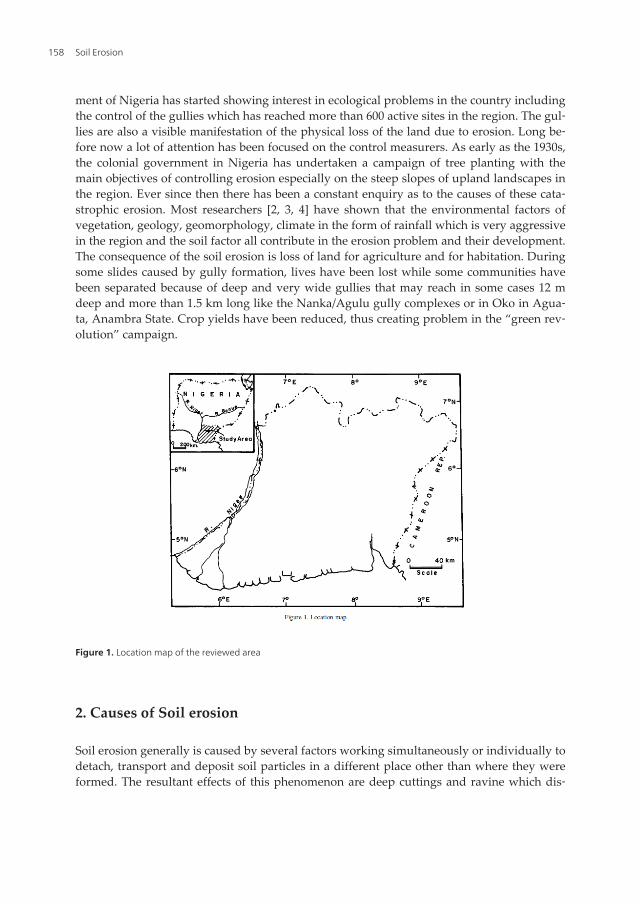
Figure 1. Location map of the reviewed area
2. Causes of Soil erosion
Soil erosion generally is caused by several factors working simultaneously or individually todetach, transport and deposit soil particles in a different place other than where they wereformed. The resultant effects of this phenomenon are deep cuttings and ravine which dis‐
Soil Erosion158
sects the entire land surface. These are very common site all over the geographical region ofsoutheastern Nigeria. It is well established fact among earth scientists that a number of envi‐ronment factors as well as pedological parameter influence the extent of soil erosion whereever it occurs globally. These factors are perhaps guided by human factors known as anthro‐pogenic factors. Although man has helped in reshaping and preserving the earth surface yetman has also helped in causing instability of equilibrium in the natural ecology and hencethe rapid spread of environmental problem such as soil erosion. Igwe [5] noted that the an‐thropogenic factors are mainly technical factors comprising mainly of land use and tillagemethods, the choice and distribution of cultures and the nature of agro-technology. InNorthern hemisphere including many countries of Europe, Giordano et al. [6] showed thatamong the factors that encourage soil erosion are vegetation clearance, intensive harvestingand over-grazing leaving the soil bare. Other factors are soil compaction caused by heavymachinery which reduces the infiltration capacity of the soil and thus promoting excessivewater runoff and soil erosion. In classical modelling works on soil erosion prediction andestimation, works by Renard et al. [7], Igwe et al. [8] among others recognised topography/relief, rainfall and soil factors as being the main agents that determine the extent of soil ero‐sion hazard. The soil factor represents the soil erodibility which is also a product of geologyand soil characteristics. In showing how these factors influence the extent of soil erosion andgullying in southeastern Nigeria, there is going to be an attempt into discussing how theseparameters contribute to gully erosion in other geographical zones.
3. The role of topography
Hudson [9] observed that in simplest terms steep land is more vulnerable to water erosionthan flat land for reasons that erosive forces, splash, scour and transport, all have greater ef‐fect on steep slopes. Soil erosion generally is a function of slope attributes. The slope lengthand the amount of soil erosion have always been proportional to the steepness of the slope.Also the slope geometry of hill sides (i.e. whether convex or concave) often contribute signif‐icantly to soil loss and gully development. In southeastern Nigeria, Ofomata [3] found thatthere is a positive relationship between relief and soil erosion while in southwestern Niger‐ia, Lal [10] observed an increased severity of soil erosion as the slope changed from 5 to 15%.On a 15% slope he recorded a total soil loss of 230 t/ha/yr from bare plots as against soil lossof 11.2 t/ha/yr on 1% slope.
The topography of southeastern Nigeria according to Ofomata [2] can be classified intothree relief units. These units are the plains and lowlands including all the river valleys, thecuesta landscapes and the highlands. It is observed that the uplands which are made up ofhighly friable sandstones yield easily to erosion and induce gullying even on slopes of about5%. The cuestas and other highlands with somewhat stable lithology resist gullying but pro‐vide aggressive runoff which moves down to devastate the lowland areas especially at thetoe slopes and river head-waters. The popular or infamous Agulu-Nanka gully erosion sitesstarted from the head waters of streams and slopes of Awka-Orlu Upland region. The gene‐
Gully Erosion in Southeastern Nigeria: Role of Soil Properties and Environmental Factorshttp://dx.doi.org/10.5772/51020
159

sis and location of this particular gully site on the landscape is similar to numerous othergully sites in the region.
Figure 2. Typical gully site
4. Influence of climate
The rainfall of southern Nigeria generally is heavy and aggressive. Rainfall amount ranges fromover 2500 mm in the southernmost region towards the Atlantic Ocean to about 1500 mm annu‐ally around River Benue in the northern borders. Rainfall intensities are high and often above 50mm/h with short interval intensities in excess of 100 mm/h. Rainfall often come between themonth of March and last till October. In some years the rainy period is unduly prolonged whilein other years their onset may be delayed for more than 5 weeks. The present global climatechange resulting from El-Niño and has not helped issues in this regard.
The nature of the rainfall regime contributes significantly to the erosivity of rainfall. Rainfallerosivity is the potential ability of rain to cause erosion. It is also a function of the physicalcharacteristics of rainfall. Obi and Salako [11] reported that the raindrop sizes obtained gen‐erally in the Guinea savannah ecological zone of West Africa ranged from 0.6 to 3.4 mm. Themean drop sizes (D50) of 28 rainfall events ranged from 1-1 to 2.9 mm. There are experimen‐tal evidence to suggest that intensity and energy are likely to be closely linked with erosivi‐ty. A number of statistical relations have been established in the past between the erosivepower and amount of rainfall in other parts of the tropical region [12, 13, 10, 14]. The bestestimator of soil loss was found to be a compound parameter, the product of the kinetic en‐ergy of the storm and intensity. In Nigeria, the total kinetic energy load of 1091 mm rainfall
Soil Erosion160
at Samaru in Northern Nigeria was about 3600 Jm-2. This was twice the amount recorded insouthern Africa by Stocking [15]. However, the product of the kinetic energy of the stormand the maximum intensity of the rainfall during the first 30 mins of a storm (EI30) was mostsignificantly correlated with soil loss determined on standard field plots [16]. Erosivity val‐ues therefore have been used successfully to produce iso-erodent map of West Africa [14].
In southeastern Nigeria, Obi and Ngwu [17] characterised the rainfall regime and recom‐mended Lal’s index of Aim as having advantage over other indices of erosivity such as KE>1 and EI30. However, Salako et al. [18] compared all the available indices of erosivity adopt‐ed in southeastern Nigeria and came up with some modifications of existing ones. Two indi‐ces EkI30 and EkIm were recommended
Where;
Ek is in MJha-1 (kinetic energy)
I30 is 30 minutes rainfall intensity and
Im being maximum intensity computed over a 6 minutes duration
Rainfall therefore plays very significant roles in the erosion hazard of southeastern Nigeria.The rainfall distribution, amount and intensity in combination of other environmental fac‐tors contribute in accelerating the rate of interrill rill and gully erosion in southeastern Ni‐geria. This is evidenced in the sense that as rainfall amount decrease northwards, the rate ofall types of soil erosion by water decreases.
5. The influence of vegetation
The constant deforestation of the former rainforest due to population explosion and in‐creased agricultural activities in the region expose the bare soils to the vagaries of weatherthus escalating the soil erosion problems. The implication is that the soils are frequently sub‐ject to different degrees of erosion including accelerated erosion. Vegetation and land useare one of the most important factors in soil erosion process in southeastern Nigeria. Stock‐ing [15] noted that vegetation acts in a variety of ways by intercepting raindrops throughencouraging greater infiltration of water and through increasing surface soil organic matterand thereby reducing soil erodibility. According to Lal [19], choosing an appropriate landuse can drastically curtail soil erosion.
In southeastern Nigeria soil erosion especially gullies are most intensive on soil on whichthe former growth has been disturbed, that is mostly on agricultural soils stripped of growthfor reasons of infrastructural developments such as road and housing construction. Ofomata[3] showed that in the region soil erosion is connected mainly with agricultural activitiesand other related land use activities such as mining, road building, urbanization, industriali‐zation and general infrastructural development. These land use activities deprive the soilsurface of its vegetation and also contribute directly to sliding, slumping, interrill and rillerosion including gullying.
Gully Erosion in Southeastern Nigeria: Role of Soil Properties and Environmental Factorshttp://dx.doi.org/10.5772/51020
161
6. The influence of geology
The general influence of lithology on soil erosion processes is manifest directly by the resist‐ance of the denuded bed rocks exposed to the flow of water and affected by the character ofparent materials whose properties are given by the bed rock. The direct effect of bedrock isalso manifest in the properties of the soil forming parent materials which conditions theprincipal properties. Some geological materials are vulnerable than others to aggressive en‐ergy of the rainfall and runoff. High erosion risks match with units of weak unconsolidatedgeological formations. This is more pronounced when such geological units coincide withmedium to long and even very long slopes with marked gradients.
In Nigeria, Ofomata [1] classified the potential erosion susceptible areas based on underly‐ing geology. He indicated that areas of high susceptibility correspond to geological regionsof weak unconsolidated sandy formations while least susceptible areas are within the con‐solidated tertiary to recent sediments. Also in southeastern Nigeria, the classical gully sitesare located in the False-bedded sandstone, Coastal Plain sands, Nanka Sands and the Bende-Ameki Formations. These are all sandy formations which have more gullies than their Shaleformation counterparts. In these formations, there exist the sites of worst catastrophic soilerosion in the whole of sub-Saharan Africa. The geology therefore plays direct and indirectinfluence on the gully formation. The indirect effect is on the soil formation and the natureof soil which contribute significantly to erosion processes. The influence of soil process onsoil erosion often referred to as erodibility is the subject of discussion in the next section.
7. The influence of soil factor (erodibility)
The erodibility of the soil is defined as the vulnerability or susceptibility of the soil to erosion. Itis a measure of a soil’s susceptibility to particle detachment and transport by agents of erosion.Igwe [20] remarked that a number of factors such as the physical and the chemical properties ofthe soil influence erodibility. In southeastern Nigeria, the nature and the long weathering his‐tory of the soils parent material evident in the dominance of the clay mineralogy by non-ex‐panding minerals and low soil organic matter concentration due to high mineralization ratesand excessive leaching of nutrients could be linked to the worsening situation. The highlyweathered soils contain high concentrations of Fe and Al oxides. Inappropriate land use andsoil management options are also a common feature of agriculture in the region. Anthropogen‐ic factors often combine to weakened soils to produce severe gullies. The soils are hence looseand slumps under high intensive rainfall that renders them easily detachable. Some of the soilshave the tendency to slake and form seals under such intense rainstorms thereby resulting inconsiderable runoff and soil erosion. The soil erodibility factor has since been recognized as acontributing factor to soil erosion hazard. The erodibility of the soils in terms of soil indices thatpredict or promote soil erosion will be elaborated on. The contributions of soil factors to soilerosion in Nigeria have variously been discussed [21, 20, 22]. Igwe et al. [21] found that the soil
Soil Erosion162
clay content, level of soil organic matter (SOM) and sesquioxides such as Al and Fe oxides, claydispersion ratio (CDR), mean-weight diameter (MWD) and geometric-mean weight diameter(GMD) of soil aggregates all influence soil erosion hazards in southeastern Nigeria. SOM, Aland Fe oxides control dispersion and flocculation of the soils. In the event of very aggressiverainfall, the soil inherent properties often combine with the physical forces of rainfall to pro‐duce soil erosion in the soils.
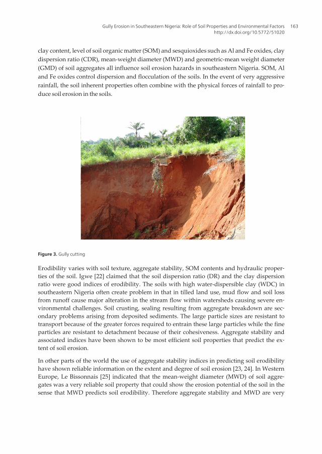
Figure 3. Gully cutting
Erodibility varies with soil texture, aggregate stability, SOM contents and hydraulic proper‐ties of the soil. Igwe [22] claimed that the soil dispersion ratio (DR) and the clay dispersionratio were good indices of erodibility. The soils with high water-dispersible clay (WDC) insoutheastern Nigeria often create problem in that in tilled land use, mud flow and soil lossfrom runoff cause major alteration in the stream flow within watersheds causing severe en‐vironmental challenges. Soil crusting, sealing resulting from aggregate breakdown are sec‐ondary problems arising from deposited sediments. The large particle sizes are resistant totransport because of the greater forces required to entrain these large particles while the fineparticles are resistant to detachment because of their cohesiveness. Aggregate stability andassociated indices have been shown to be most efficient soil properties that predict the ex‐tent of soil erosion.
In other parts of the world the use of aggregate stability indices in predicting soil erodibilityhave shown reliable information on the extent and degree of soil erosion [23, 24]. In WesternEurope, Le Bissonnais [25] indicated that the mean-weight diameter (MWD) of soil aggre‐gates was a very reliable soil property that could show the erosion potential of the soil in thesense that MWD predicts soil erodibility. Therefore aggregate stability and MWD are very
Gully Erosion in Southeastern Nigeria: Role of Soil Properties and Environmental Factorshttp://dx.doi.org/10.5772/51020
163
reliable properties in explaining, quantifying or predicting soil erosion and other soil prob‐lems such as crusting and sealing.
Again other soil properties encourage structural failure, sliding and mass movement of soils.These soil factors are the mineralogy of the clay and even the soil chemical properties. The sta‐bility of the soil mass is therefore depended on the clay minerals present. Illite and smectitemore readily form aggregates but the more open lattice structure of these minerals and thegreater swelling and shrinkage which occur on wetting and drying render the aggregates lessstable than those formed from kaolinite. Soils in which either kaolinite or illite clay predomi‐nates but contains small amounts of smectite are easily dispersive. Smectitic soils are moreerodible than the soils that contain only small amount of smectite. Conversely, soils that do notcontain smectite are more stable, less erodible and less susceptible to seal formation.
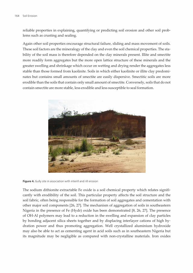
Figure 4. Gully site in association with interill and rill erosion
The sodium dithionite extractable Fe oxide is a soil chemical property which relates signifi‐cantly with erodibility of the soil. This particular property affects the soil structure and thesoil fabric, often being responsible for the formation of soil aggregates and cementation withother major soil components [26, 27]. The mechanism of aggregation of soils in southeasternNigeria in the presence of Fe (Hydr) oxide has been demonstrated [8, 26, 27]. The presenceof OH-Al polymers may lead to a reduction in the swelling and expansion of clay particlesby bonding adjacent silica sheets together and by displacing interlayer cations of high hy‐dration power and thus promoting aggregation. Well crystallized aluminium hydroxidemay also be able to act as cementing agent in acid soils such as in southeastern Nigeria butits magnitude may be negligible as compared with non-crystalline materials. Iron oxides
Soil Erosion164
therefore are more effective than aluminium hydroxide in cement effectiveness except forsoils undergoing frequent oxidation-reduction processes.
8. Anthropogenic influence
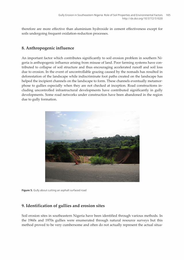
An important factor which contributes significantly to soil erosion problem in southern Ni‐geria is anthopogenic influence arising from misuse of land. Poor farming systems have con‐tributed to collapse of soil structure and thus encouraging accelerated runoff and soil lossdue to erosion. In the event of uncontrollable grazing caused by the nomads has resulted indeforestation of the landscape while indiscriminate foot paths created on the landscape hashelped the incipient channels on the landscape to form. These channels eventually metamor‐phose to gullies especially when they are not checked at inception. Road constructions in‐cluding uncontrolled infrastructural developments have contributed significantly in gullydevelopments. Some road networks under construction have been abandoned in the regiondue to gully formation.
Figure 5. Gully about cutting an asphalt surfaced road
9. Identification of gullies and erosion sites
Soil erosion sites in southeastern Nigeria have been identified through various methods. Inthe 1960s and 1970s gullies were enumerated through natural resource surveys but thismethod proved to be very cumbersome and often do not actually represent the actual situa‐
Gully Erosion in Southeastern Nigeria: Role of Soil Properties and Environmental Factorshttp://dx.doi.org/10.5772/51020
165
tion on ground. This led to the use of aerial photo interpretation (API) in the generation ofinformation for soil erosion studies. Niger Techno & Technital Spa [28] employed API in thedocumentation and publication of soil erosion problems in eastern Nigeria. The other meth‐ods in this category is remotely acquired data from satellites, radar imageries and from geo‐graphic information systems GIS. The advantages of API and other remotely acquiredinformation is that the information they show are real and exact and sometimes in real time.However, acquiring information through this source is very expensive and most often unaf‐fordable by some governments and establishments in Nigeria.
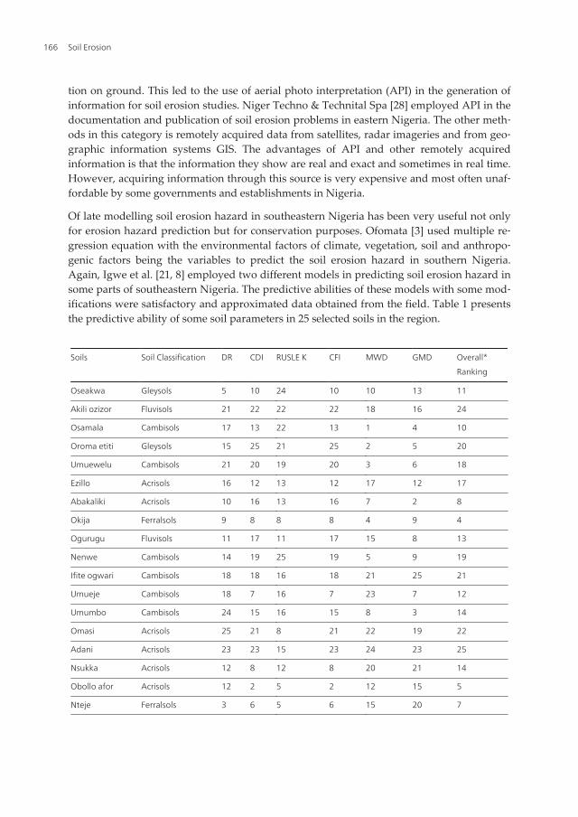
Of late modelling soil erosion hazard in southeastern Nigeria has been very useful not onlyfor erosion hazard prediction but for conservation purposes. Ofomata [3] used multiple re‐gression equation with the environmental factors of climate, vegetation, soil and anthropo‐genic factors being the variables to predict the soil erosion hazard in southern Nigeria.Again, Igwe et al. [21, 8] employed two different models in predicting soil erosion hazard insome parts of southeastern Nigeria. The predictive abilities of these models with some mod‐ifications were satisfactory and approximated data obtained from the field. Table 1 presentsthe predictive ability of some soil parameters in 25 selected soils in the region.
Soils Soil Classification DR CDI RUSLE K CFI MWD GMD Overall*
Ranking
Oseakwa Gleysols 5 10 24 10 10 13 11
Akili ozizor Fluvisols 21 22 22 22 18 16 24
Osamala Cambisols 17 13 22 13 1 4 10
Oroma etiti Gleysols 15 25 21 25 2 5 20
Umuewelu Cambisols 21 20 19 20 3 6 18
Ezillo Acrisols 16 12 13 12 17 12 17
Abakaliki Acrisols 10 16 13 16 7 2 8
Okija Ferralsols 9 8 8 8 4 9 4
Ogurugu Fluvisols 11 17 11 17 15 8 13
Nenwe Cambisols 14 19 25 19 5 9 19
Ifite ogwari Cambisols 18 18 16 18 21 25 21
Umueje Cambisols 18 7 16 7 23 7 12
Umumbo Cambisols 24 15 16 15 8 3 14
Omasi Acrisols 25 21 8 21 22 19 22
Adani Acrisols 23 23 15 23 24 23 25
Nsukka Acrisols 12 8 12 8 20 21 14
Obollo afor Acrisols 12 2 5 2 12 15 5
Nteje Ferralsols 3 6 5 6 15 20 7
Soil Erosion166

Soils Soil Classification DR CDI RUSLE K CFI MWD GMD Overall*
Ranking
Awka Acrisols 2 1 5 1 13 16 2
Idodo Acrisols 20 24 20 24 14 14 22
Ukehe Acrisols 7 4 8 4 19 22 8
Abor Acrisols 4 4 2 4 9 18 3
Nachi Acrisols 6 11 4 11 25 24 14
Nanka Acrisols 7 14 2 14 11 1 6
Nawfija Acrisols 1 3 1 3 5 11 1
*1- most erodible; 25- least erodible; DR- Dispersion ratio; CDI- clay dispersion index; RUSLE K- Wischmeier erodibilityfactor (K); CFI- clay flocculation index; MWD- mean-weight diameter of soil aggregates; GMD- geometric mean-weight diameter of soil aggregates (Source: Igwe et al [21]).
Table 1. Ranking of soils in order of significant erosion predictability
In other parts of the world the use of some soil parameters such as the water-dispersible clay(WDC) has been adopted as a major parameter in soil erosion models as in the Water Ero‐sion Prediction Project (WEPP) [29]. This method has been widely used in the developmentof soil erosion models for some parts of eastern Nigeria [22]. Soils with high WDC have highsoil erosion potential and therefore WDC constitutes a great problem to the soil and the en‐tire environment. The negative influence of high clay dispersion on soil erosion results indetachment, transportation and deposition of sediments with essential plant nutrient ele‐ments down stream. This clay associated sediments constitute high environmental menaceto man, livestock and agricultural fields. The streams and rivers are silted, while the aquaticlife suffers serious problems due to high concentration of nitrates, organic matter and phos‐phorus in clay suspension down stream. These information have served as basic informationfor soil conservation processes
10. Control and Remediation
The state of soil erosion problem in southeastern Nigeria calls for a comprehensive soil con‐servation programme so as to check catastrophic erosion hazard. The soil conservationmeasures should be those farming system practises which ensure sustainable soil productiv‐ity while maintaining equilibrium between the ecosystem and regular anthropogenic influ‐ence. In the design of soil conservation strategies, the permissible soil loss tolerance so as toavoid catastrophe in the event of failures of such strategies. In the United States of America,the permissible soil erosion loss is between 2.5 and 12.5 t ha-1 y-1 [7], while in Czech Repub‐lic, Holy [30] noted that the permissible soil loss was between 1.0 to 16 t ha-1 y-1 in very deepsoil of 120 cm thickness. Obi [31] observed that for a highly weathered, porous and deep ul‐
Gully Erosion in Southeastern Nigeria: Role of Soil Properties and Environmental Factorshttp://dx.doi.org/10.5772/51020
167
tisol in southeastern Nigeria, the tolerable soil loss was about 10 t ha-1 y-1 under maize pro‐duction, with appreciable loss in the production capacity of the soils.
Therefore, the suggested soil conservation measures based on the agricultural land use isrecommended for the entire agro-ecological system. The land use option suitable to the areashould be that based on integrated watershed management with arable farming, agrofores‐try and intensive afforestation. These practises are considered cheap option which can be af‐forded by the rural poor farmer. The methods are also very sustainable and not destructiveto the agricultural land. This is aimed at reducing the annual soil loss rate and prevents thedevelopment of fresh gullies in the area. Agricultural land use should be based on topo‐graphic variations, major soil distribution, soil potential erosion hazard, hydrology and oth‐er geomorphological variables. Igwe [4] recommended that the entire region should bepartitioned into 4 broad sections based on their location on the landscape. The lowlands andvalley floors which also contain sediments should be put to rainfed and irrigated farming ofarable crops. The main soil conservation strategies should be those that improve plant nu‐trient availability, land levelling in case of irrigation and drainage. On the land areas that areon 5% slope and below, the regular recommended cultural practises of organic matter appli‐cation to the soil is suggested while mulching, crop rotation and well managed agro-forestryare some of the ways of keeping the soil uneroded. Crop residues in association with tillagesystems contribute immensely in the conservation of the soil or other wise. The other re‐maining 2 land units are those that vary between 5-30 % slope and mostly the sites of cata‐strophic gullies in the area. They should be permanently forested and may be used forwildlife conservation. The kind of forestation should be that which produces intimate multi-storeyed association of woody species, grasses and creeping legumes. This will ensuresteady cover for the bare soil and offer some kind of protection to the soil against the highintensive and aggressive rainfall. The major soil conservation strategies are broad-based ter‐races and cover cropping of bare soils. A more comprehensive soil conservation method willinvolve the application of certain hydrological or bioenvironmental processes so as to con‐trol the overland flow and excessive runoff.
11. Conclusion
Soil erosion in the form of gullies is very common in southeastern Nigeria. This review hasshown the influence of geology, climate, geomorphology (slope), vegetation, man and soil it‐self on gully development and soil erosion in general. Typical empirical examples are citedfrom previous works from other researchers in other parts of the world and locally. Past workson estimation of potential soil erosion hazard in the region indicate that more than 1.6% of theentire land area has been devastated by gullies. The inherent characteristics of the local soils toa large extent promote the spread of soil erosion especially the gully type in the region. Theroles of anthropogenic factors with regards to land use and its influence on the vegetation areconsidered. The serious deforestation of the vegetation and poor revegetation or afforestationprogrammes have all contributed to the catastrophic erosion hazards. General strategies for
Soil Erosion168
soil conservation with respect to soil erosion should include a more comprehensive soil conser‐vation method which will involve the application of certain hydrological or bioenvironmentalprocesses so as to control the overland flow and excessive runoff.
Author details
C.A. Igwe
Address all correspondence to: [email protected]
Department of Soil Science, University of Nigeria, Nsukka, Nigeria
References
[1] Ofomata, G.E.K. (1981). Acrtual and Potential erosion in Nigeria and measures forcontrol. Soil Science Society of Nigeria Special Monograph 1, 151-165.
[2] Ofomata, G. E. K. (1975). Soil erosion. Nigeria in maps, Eastern States, Ethiope Publish‐ing House, Benin City Nigeria.
[3] Ofomata, G. E. K. Soil erosion. Southeastern Nigeria: the view of a geomorphologist,Inaugural lecture series University of Nigeria Nsukka (1985).
[4] Igwe, C. A. (1999). Land use and soil conservation strategies for potentially highlyerodible soils of central-eastern Nigeria. Land Degradation Development [10], 425-434.
[5] Igwe, C.A. (1994). The applicability of SLEMSA and USLE erosion models on soils ofsoutheastern Nigeria,. PhD Thesis, University of Nigeria, Nsukka.
[6] Giordano, A., Bonfils, P., & Briggs, D. J. (1991). Menezes de Sequeira E., RoqueroD.L.C., Yassoglou A. the methodological approach to soil erosion and important landresources evaluation of the European community. Soil Technology [4], 65-77.
[7] Renard, K. G., Foster, G. R., Weesies, G. A., Mc Cool, D. K., & Yoder, D. C. (1997).Predicting Soil Erosion by Water: A Guide to Conservation Planning with the Re‐vised Universal Soil Loss Equation. U.S. Department of Agriculture, Agriculture Hand‐book, 703, 384pp.
[8] Igwe, C. A., Akamigbo, F. O. R., & Mbagwu, J. S. C. (1999). Chemical and mineralogi‐cal properties of soils in southeastern Nigeria in relation to aggregate stability. Geo‐derma [92], 111-123.
[9] Hudson, N.W. (1981). Soil conservation, Cornell University Press, New York.
[10] Lal, R. (1976a). Soil erosion on alfisols in Western Nigeria. I. Effects of slope, crop ro‐tation and residue management. Geoderma, 16, 363-373.
Gully Erosion in Southeastern Nigeria: Role of Soil Properties and Environmental Factorshttp://dx.doi.org/10.5772/51020
169

[11] Obi, M.E., & Salako, F.K. (1995). Rainfall parameters influencing erosivity in south‐eastern Nigeria. Catena. 24, 275-287.
[12] Morgan, R.P.C. (1974). Estimating regional variations in soil erosion hazard in Penin‐sular Malaysia. Malaysian Nature Journal [28], 94-106.
[13] Kowal, J. M., & Kossam, A. H. (1976). Energy load and instantaneous intensity ofrainstorms at Samaru, Northern Nigeria. Tropical Agriculture [53], 185-198.
[14] Roose, E.J. (1977). Application of universal soil loss equation of Wischmeier & Smithin west Africa. Greenland D.J. & Lal R (eds), Soil conservation and management in the hu‐mid tropics, 177-188.
[15] Stocking, M.A.A. (1987). Methodology for erosion hazard mapping of the SADCC re‐gion. Paper presented at the workshop on erosion hazard mapping, Lusaka, Zambia, April.
[16] Lal, R. (1976b). Soil erosion on alfisols in Western Nigeria. I. Effects of rainfall charac‐teristics. Geoderma, 16, 389-401.
[17] Obi, M. E., & Ngwu, O. E. (1988). Characterization of the rainfall regime for the pre‐diction of surface runoff and soilloss in southeastern Nigeria. Beitrage für TropicalischeLandwirtschaften und Vetrinarimedizin [26], 39-46.
[18] Salako, F. K., Obi, M. E., & Lal, R. (1991). Comparative assessment of several rainfallerosivity indices in southern Nigeria. Soil Technology [4], 93-97.
[19] Lal, R. (1983). Soil erosion in the humid tropics with particular reference to agricul‐tural land development and soil management. Proceedings of the Hamburg Symposium.IAHS Publication 140, August, 221-239.
[20] Igwe, C.A. (2003). Erodibility of soils of the upper rainforest zone, southeastern Ni‐geria. Land Degradation & Development [14], 323-334.
[21] Igwe, C. A., Akamigbo, F. O. R., & Mbagwu, J. S. C. (1995). The use of some soil ag‐gregate indices to assess potential soil loss in soils of Southeastern Nigeria. Interna‐tional Agrophysics [9], 95-100.
[22] Igwe, C.A. Erodibility in relation to water-dispersible clay for some soils of easternNigeria. Land Degradation and Development (2005). , 2005(16), 87-96.
[23] Bryan, R.B. (1968). The development, use and efficiency of indices of soil erodibility.Geoderma [2], 5-26.
[24] Bajracharya, R. M., Elliot, W. J., & Lal, R. (1992). Interrill erodibility of some Ohiosoils based on field rainfall simulation. Soil Science Society of America Journal [56],267-272.
[25] Le Bissonnais, Y. Experimental study and modelling of soil surface crusting process‐es. Catena Suppl., 1990(17), 13-28.
Soil Erosion170
[26] Igwe, C. A., & Stahr, K. Water-stable aggregates of flooded inceptisols from south‐eastern Nigeria in relation to mineralogy and chemical properties. Australian Journalof Soil Research (2004). (42), 171-179.
[27] Igwe, C. A., Zarei, M., & Stahr, K. (2009). Colloidal stability in some tropical soils ofsoutheastern Nigeria as affected by iron and aluminium oxides. Catena, 2009(77),232-237.
[28] Niger Techno & Technital Spa. Pre-feasibility study of soil erosion in East CentralState of Nigeria (1979). pp., 1
[29] Lane, L.J., & Nearing, M.A. (1989). USDA-Water erosion Prediction project. Hillslopeprofile version. NSERL Report 2 West Lafayette, 259.
[30] Holy, M. (1980). Erosion and environment- Environmental Sciences and applications, 9,Pergamon Press Ltd, 225.
[31] Obi, M.E. (1982). Runoff and soil loss from an oxisol in southeastern Nigeria undervarious management practices. Agricultural Water Management [5], 193-203.
Gully Erosion in Southeastern Nigeria: Role of Soil Properties and Environmental Factorshttp://dx.doi.org/10.5772/51020
171
