guiuan - emergency management · the present map shows basic topographic features such as...
TRANSCRIPT
The present map shows basic topographic features such as transportation, hydrology andsettlements in the area of Guiuan, Philippines. These basic topographic features are derivedfrom public datasets, refined by means of visual interpretation of pre-event Pleiades image(acquired on 27/08/2013 at 2:17 UTC, GSD 0.8 m, 0% cloud coverage).All satellite images have been radiometrically enhanced and orthocorrected with RPCapproach (using SRTM elevation data).The estimated geometric accuracy of this product is 8 m CE90 or better, from nativepositional accuracy of the background satellite image.The estimated thematic accuracy of this product is 85% or better, as it is based on visualinterpretation of recognizable items on very high resolution optical imagery.Map produced on 16/11/2013 by ITHACA under contract 257219 with the EuropeanCommission. All products are © of the European Commission.Name of the release inspector (quality control): e-GEOS (ODO).E-mail: [email protected]
!
n|
n|
"
£
!
r
m
9
9
4
4
4
4
4
4
4
4
^
^
K
K
K
GuiuanMunicipial Port
GuiuanAirportGuiuan
Municipial Hall
Guiuan Police Station
Guiuan PublicCemetery
St. Mary Immaculate
South SamarGeneral Hospital
Agpalo HospitalGuiuan Polymedic
ImmaculateConception HospitalGuiuan
125°45'30"E
125°45'30"E
125°45'0"E
125°45'0"E
125°44'30"E
125°44'30"E
125°44'0"E
125°44'0"E
125°43'30"E
125°43'30"E
125°43'0"E
125°43'0"E
125°42'30"E
125°42'30"E11
°3'0"
N 11°3
'0"N
11°2
'30"N 11
°2'30
"N
11°2
'0"N 11
°2'0"
N
11°1
'30"N 11
°1'30
"N
11°1
'0"N 11
°1'0"
N11
°0'30
"N
796000
796000
797000
797000
798000
798000
799000
799000
800000
800000
801000
801000
1219
000
1219
000
1220
000
1220
000
1221
000
1221
000
1222
000
1222
000
1223
000
1223
000
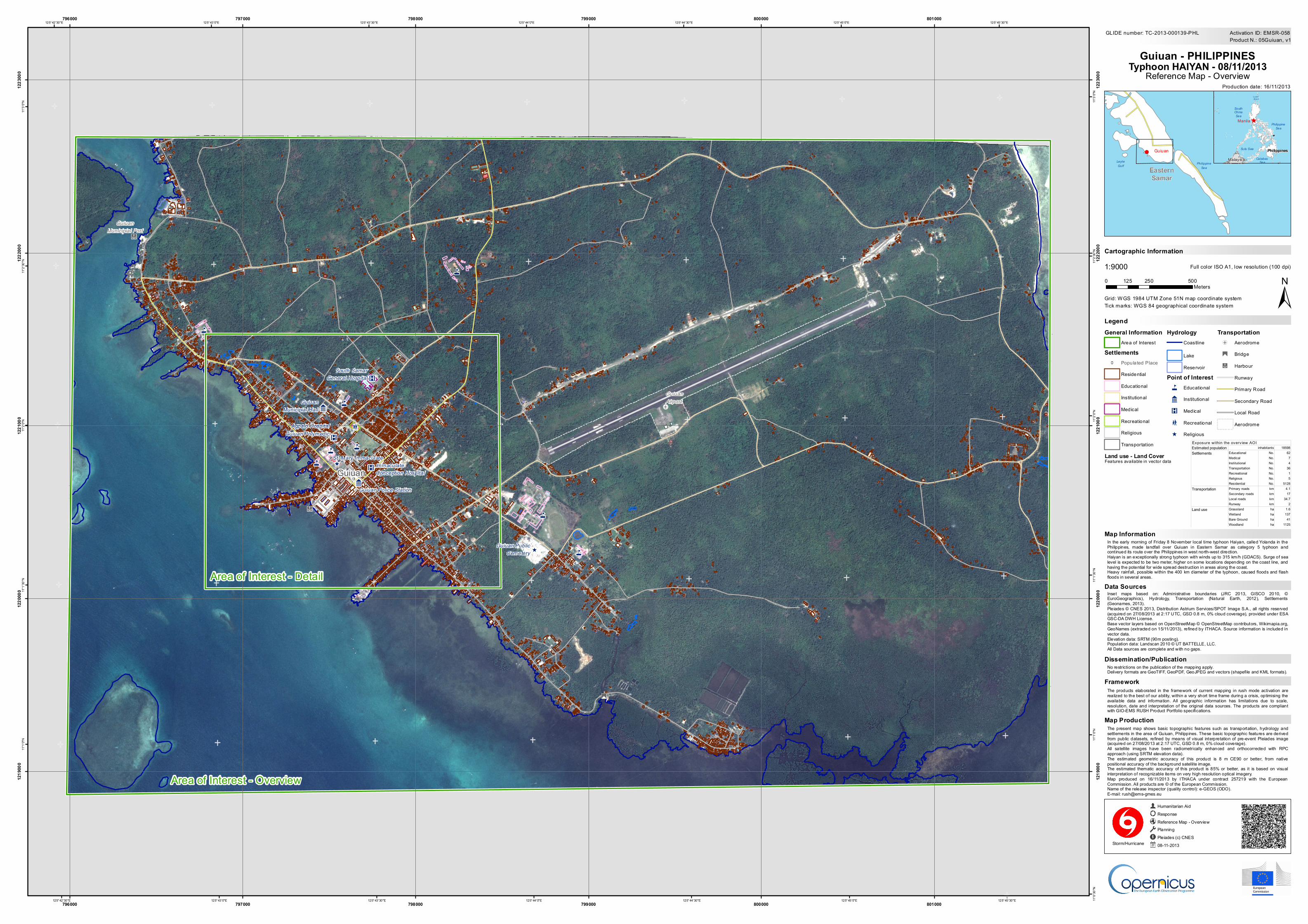
GLIDE number: TC-2013-000139-PHL
!( Guiuan
PhilippineSea
LeyteGulf Eastern
Samar
^ManilaPhilippine
Sea
SouthChinaSea
CelebesSea
Sulu Sea
LuzonSt ra it
MalaysiaPhilippines
Production date: 16/11/2013
Cartographic Information
1:9000
±Grid: WGS 1984 UTM Zone 51N map coordinate system
Full color ISO A1, low resolution (100 dpi)
The products elaborated in the framework of current mapping in rush mode activation arerealized to the best of our ability, within a very short time frame during a crisis, optimising theavailable data and information. All geographic information has limitations due to scale,resolution, date and interpretation of the original data sources. The products are compliantwith GIO-EMS RUSH Product Portfolio specifications.
In the early morning of Friday 8 November local time typhoon Haiyan, called Yolanda in thePhilippines, made landfall over Guiuan in Eastern Samar as category 5 typhoon andcontinued its route over the Philippines in west north-west direction.Haiyan is an exceptionally strong typhoon with winds up to 315 km/h (GDACS). Surge of sealevel is expected to be two meter, higher on some locations depending on the coast line, andhaving the potential for wide spread destruction in areas along the coast.Heavy rainfall, possible within the 400 km diameter of the typhoon, caused floods and f lashfloods in several areas.
No restrictions on the publication of the mapping apply.Delivery formats are GeoTIFF, GeoPDF, GeoJPEG and vectors (shapefile and KML formats).
Legend
Tick marks: WGS 84 geographical coordinate system
Product N.: 05Guiuan, v1Activation ID: EMSR-058
Inset maps based on: Administrative boundaries (JRC 2013, GISCO 2010, ©EuroGeographics), Hydrology, Transportation (Natural Earth, 2012), Settlements(Geonames, 2013).Pleiades © CNES 2013, Distribution Astrium Services/SPOT Image S.A., all rights reserved(acquired on 27/08/2013 at 2:17 UTC, GSD 0.8 m, 0% cloud coverage), provided under ESAGSC-DA DWH License.Base vector layers based on OpenStreetMap © OpenStreetMap contributors, Wikimapia.org,GeoNames (extracted on 15/11/2013), refined by ITHACA. Source information is included invector data.Elevation data: SRTM (90m posting).Population data: Landscan 2010 © UT BATTELLE, LLC.All Data sources are complete and with no gaps.
Humanitarian AidResponseReference Map - OverviewPlanningPleiades (c) CNES08-11-2013Storm/Hurricane
0 250 500125Meters
Guiuan - PHILIPPINESTyphoon HAIYAN - 08/11/2013
Reference Map - Overview
Data Sources
Map Information
Dissemination/Publication
Framework
Map Production
Area of Interest - Detail
Land use - Land CoverFeatures available in vector data
General InformationArea of Interest
Settlements! Populated Place
Residential
Educational
Institutional
Medical
Recreational
Religious
Transportation
HydrologyCoastline
Lake
ReservoirPoint of Interest4 Educational
9 Institutional
K Medical
m Recreational
^ Religious
Transportation!
r Aerodrome
"
£ Bridge
n| Harbour
Runway
Primary Road
Secondary Road
Local Road
Aerodrome
Area of Interest - Overview
Estimated population 18598Educational No. 62Medical No. 7Institutional No. 4Transportation No. 36Recreational No. 1Religious No. 5Residential No. 5128Primary roads km 4.1Secondary roads km 17Local roads km 34.7Runway km 2Grassland ha 1.6Wetland ha 137Bare Ground ha 41Woodland ha 1125
Land use
Exposure within the overview AOI inhabitants
Settlements
Transportation