greene county soil & water conservation district 907 ... · greene county soil & water...
TRANSCRIPT
Greene County Soil & Water Conservation District
907 County Office Building, Cairo NY 12413 Phone (518) 622-3620 Fax (518) 622-0344
To: David Burns, Project Manager, NYCDEP From: Jeff Flack, Executive Director, GCSWCD Date: May 9, 2011 Re: Schoharie Basin Action Plan To Whom It May Concern, The Greene County Soil and Water Conservation District (GCSWCD) and the NYC Department of Environmental Protection (DEP) have collaborated with the Schoharie Watershed Advisory Committee (SWAC) to develop the 2011– 2013 Action Plan. The Action Plan is one piece of a three-part package that includes: Section 1. Executive Summary: Schoharie Basin Stream Management Program Action Plan
2011-2013 Section 2. Schoharie Basin Stream Management Program Action Plan 2011-2013 Section 3. Completed Action Items May 2007 through May 2011
Enclosed you will find each of these documents. The Action Plan provides summaries of the projects and programs that GCSWCD will be leading between May 2011 and May 2013. The completed projects synopsis provides summaries of the action items that have been completed from previous Action Plans (May 2007-May 2011). The executive summary provides a brief description and the current status of action plan items from the 2011 – 2013 Action Plan, as well as completed items from May 2009 to present. The complete action plan and completed project synopsis are updated annually and revised biannually. The executive summary is a working document that is updated more frequently for the SWAC.
Schoharie BasinStream Management Program Action Plan 2011-2013
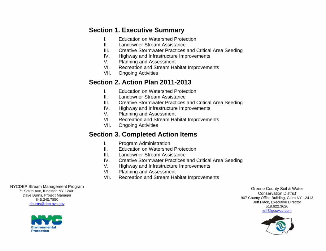
Section 1. Executive Summary I. Education on Watershed Protection II. Landowner Stream Assistance III. Creative Stormwater Practices and Critical Area Seeding IV. Highway and Infrastructure Improvements V. Planning and Assessment VI. Recreation and Stream Habitat Improvements VII. Ongoing Activities
Section 2. Action Plan 2011-2013 I. Education on Watershed Protection II. Landowner Stream Assistance III. Creative Stormwater Practices and Critical Area Seeding IV. Highway and Infrastructure Improvements V. Planning and Assessment VI. Recreation and Stream Habitat Improvements VII. Ongoing Activities
Section 3. Completed Action Items I. Program Administration II. Education on Watershed Protection III. Landowner Stream Assistance IV. Creative Stormwater Practices and Critical Area Seeding V. Highway and Infrastructure Improvements VI. Planning and Assessment VII. Recreation and Stream Habitat Improvements
NYCDEP Stream Management Program 71 Smith Ave, Kingston NY 12401
Dave Burns, Project Manager 845.340.7850
Greene County Soil & Water Conservation District
907 County Office Building, Cairo NY 12413 Jeff Flack, Executive Director
518.622.3620 [email protected]
Section 1. Executive Summary: Schoharie Basin
Stream Management Program
Action Plan 2011-2013
May 15, 2011
NYCDEP Stream Management Program
71 Smith Ave, Kingston NY 12401
Dave Burns, Project Manager
Greene County Soil & Water Conservation District
907 County Office Building, Cairo NY 12413
Jeff Flack, Executive Director
2011 Action Plan Executive Summary, 2011‐2013* * ‐ For more information, including projects completed prior to 2009, refer to the complete action plan available at www.catskillstreams.org/majorstreams_sc.html
^ - SMIP = Stream Management Implementation Grant Program, CSBI = Catskill Streams Buffer Initiative, WAP = Watershed Assistance Program, WRDA = Water Resources Development Act (ACOE), CWC = Catskill Watershed Corporation, General = DEP/GCSWCD SWSMP
2011 Schoharie Watershed Action Plan Executive Summary Page 1 of 17
2011 Action Plan Executive Summary, 2011-2013
Introduction
The Schoharie Watershed Stream Management Program (SWSMP) was established in partnership with the Greene County Soil & Water Conservation District (GCSWCD) and NYC Department of Environmental Protection (DEP) in 1997 as part of the Filtration Avoidance Determination (FAD) issued to DEP by the Environmental Protection Agency. Stream Management Plans have been completed for each major river corridor in the Schoharie Watershed and each plan includes a set of general recommendations and project specific recommendations which provide a “road map” for improved stream and floodplain management. In addition to supporting the FAD, many SWSMP projects also target reductions to in-stream sources of suspended sediment to partially fulfill requirements set forth in DEP’s Shandaken Tunnel State Pollution Discharge Elimination System (SPEDES) permit established in September 2006. The following Action Plan Executive Summary summarizes the programs and projects that GCSWCD will be leading within the Schoharie Basin between May 2011 and May 2013, as well as programs and projects completed from May 2009 to present. The SWSMP seeks to advance state-of-the-art watershed management projects, policies and programs to improve and protect the Schoharie Watershed. Initiatives include the Stream Management Implementation Program (SMIP), the Catskill Streams Buffer Initiative (CSBI), Stream and Floodplain Restoration Projects, Stream and Watershed Assessments, and Education and Outreach programs. The funding source for each item is noted in the right column with “General” referring to the item as being a program or project of the GCSWCD/DEP Schoharie Watershed Stream Management Program.
2011 Action Plan Executive Summary, 2011‐2013* * ‐ For more information, including projects completed prior to 2009, refer to the complete action plan available at www.catskillstreams.org/majorstreams_sc.html
^ - SMIP = Stream Management Implementation Grant Program, CSBI = Catskill Streams Buffer Initiative, WAP = Watershed Assistance Program, WRDA = Water Resources Development Act (ACOE), CWC = Catskill Watershed Corporation, General = DEP/GCSWCD SWSMP
2011 Schoharie Watershed Action Plan Executive Summary Page 2 of 17
Education on Watershed Protection The Schoharie Watershed Stream Management Program will be administering four annual events focused on education and awareness and twelve Education and Outreach projects between 2011 and 2013. The GCSWCD will continue to work with a wide network of partners to enhance its education and outreach efforts related to stream and floodplain management, sediment and erosion control, and other topics critical to sound watershed management.
Annual Projects
Project Progress Notes Year
Added to AP
Program^
Schoharie Watershed Month (formerly Week)
Annual Annually plan and hold action-focused educational and recreational event for community involvement and awareness- held May 2010 and 2011.
2009 SMIP Round 2/ General/WAP
Batavia Kill Stream Celebration
Annual Annually plan and hold streamside educational celebratory event - held in August 2007, 2008, 2009, 2010 and scheduled for August 2011.
2009 General/Other/WAP
Schoharie Watershed Summit
Annual Annually plan and hold seminar-based training and educational event for municipal officials - held in January 2007, 2008, 2009, 2010 and 2011.
2009 General/WAP
Schoharie Watershed Tour
Annual Annually plan and hold Watershed Tour - held in June 2007, 2008, 2009, 2010.
2009 General/WAP
2011 Action Plan Executive Summary, 2011‐2013* * ‐ For more information, including projects completed prior to 2009, refer to the complete action plan available at www.catskillstreams.org/majorstreams_sc.html
^ - SMIP = Stream Management Implementation Grant Program, CSBI = Catskill Streams Buffer Initiative, WAP = Watershed Assistance Program, WRDA = Water Resources Development Act (ACOE), CWC = Catskill Watershed Corporation, General = DEP/GCSWCD SWSMP
2011 Schoharie Watershed Action Plan Executive Summary Page 3 of 17
2011-2013 Projects
Project Progress Notes Year
Added to AP
Program^
Mountain Top Arboretum Outdoor Classroom Construction
Contracting
Arboretum will construct an accessible outdoor classroom for year-round outdoor programming on a range of ecological and natural history topics relating to the watershed. Design plans and bid specifications for the classroom construction were developed through SMIP Round 2. Project located in Hunter.
2011 SMIP Round 4
Environmental Film Series
In-Process Watershed Agricultural Council will host an environmental film series highlighting watershed issues. Part of Schoharie Watershed Month 2011.
2011 SMIP Round 4
Roadside Ditch Maintenance Workshop
In-Process GCSWCD will conduct a workshop for highway departments on importance of prioritizing ditch scraping, and different methods and materials available based on ditch conditions. Scheduled for June 2011.
2011 SMIP Round 4
Riparian Buffer Workshop
In-Process GCSWCD’s CSBI will host a workshop for streamside landowners that will highlight the importance of buffers and demonstrate management practices to maintain healthy stream buffers.
2011 CSBI/General
Water Quality at Home Workshops
In-Process
Greene County Cornell Cooperative Extension will implement 3 action-based educational workshops - building rain barrels, holistic pond management, and eco-landscaping. Part of Schoharie Watershed Month 2011.
2010 SMIP Round 3
Schoharie Watershed Stream Crossing Workshop
Contracting GCSWCD staff will develop and implement a culvert design workshop for local highway departments.
2010 SMIP Round 3
CD Lane Family Day
Contracting Windham Chamber of Commerce will promote outdoor activities involving hands on experience with water activities. Part of Schoharie Watershed Month 2011.
2010 SMIP Round 3
Manor Kill Information Kiosk
In-Process Schoharie County SWCD will create a kiosk highlighting the Manor Kill, watershed protection efforts, and agencies and programs serving the area.
2010 SMIP Round 2
2011 Action Plan Executive Summary, 2011‐2013* * ‐ For more information, including projects completed prior to 2009, refer to the complete action plan available at www.catskillstreams.org/majorstreams_sc.html
^ - SMIP = Stream Management Implementation Grant Program, CSBI = Catskill Streams Buffer Initiative, WAP = Watershed Assistance Program, WRDA = Water Resources Development Act (ACOE), CWC = Catskill Watershed Corporation, General = DEP/GCSWCD SWSMP
2011 Schoharie Watershed Action Plan Executive Summary Page 4 of 17
Manor Kill Environmental Study Team
In-Process The Schoharie River Center will involve youth and their families in water quality monitoring and testing, taxonomy, riparian zone restoration, invasive species identification and public outreach.
2009 SMIP Round 1
Identify Existing Resources
In-Process Identify existing educational, technical assistance and funding programs. 2009 General/WAP
Complete Kiosk Series
Near-Complete Kiosks highlighting project sites and best management practices.
2009 General
Completed Projects
Project Progress Notes Year
CompletedProgram^
Floodplain Management and Wetland Protection Workshops
Complete Trainings were conducted by DEC and EPA at the annual Watershed Summits in January 2008, 2009, 2010 and 2011.
2011 General/WAP
Japanese Knotweed Mailing
Complete Distributed knotweed informational brochure to streamside landowners. 2010 General
Riparian Buffer Workshop
Complete CSBI sponsored workshop July 10, 2010 that showed participants the characteristics of healthy vs. degraded buffers and different management practices to maintain healthy stream buffers.
2010 CSBI
Erosion and Sediment Control Workshops
Complete Trainings on sediment and erosion control for compliance with SPDES General Permit for construction activities were held in December 2008, January 2009 and March 2010.
2010
General
Mountain Top Arboretum Outdoor Classroom Design
Complete Design plans and bid specifications for an accessible outdoor classroom were completed in 2010.
2010 SMIP Round 2
Rain Barrel Workshop
Complete Cornell Cooperative Extension workshop took place during Schoharie Watershed Week May, 2010. Fifteen people took part in building their own rain barrels.
2010 SMIP Round 2
2011 Action Plan Executive Summary, 2011‐2013* * ‐ For more information, including projects completed prior to 2009, refer to the complete action plan available at www.catskillstreams.org/majorstreams_sc.html
^ - SMIP = Stream Management Implementation Grant Program, CSBI = Catskill Streams Buffer Initiative, WAP = Watershed Assistance Program, WRDA = Water Resources Development Act (ACOE), CWC = Catskill Watershed Corporation, General = DEP/GCSWCD SWSMP
2011 Schoharie Watershed Action Plan Executive Summary Page 5 of 17
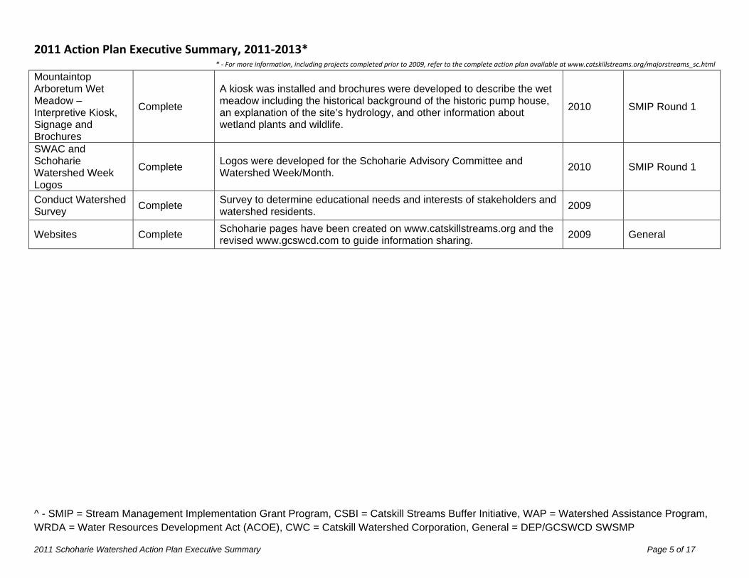
Mountaintop Arboretum Wet Meadow – Interpretive Kiosk, Signage and Brochures
Complete
A kiosk was installed and brochures were developed to describe the wet meadow including the historical background of the historic pump house, an explanation of the site’s hydrology, and other information about wetland plants and wildlife.
2010 SMIP Round 1
SWAC and Schoharie Watershed Week Logos
Complete Logos were developed for the Schoharie Advisory Committee and Watershed Week/Month.
2010 SMIP Round 1
Conduct Watershed Survey
Complete Survey to determine educational needs and interests of stakeholders and watershed residents.
2009
Websites Complete Schoharie pages have been created on www.catskillstreams.org and the revised www.gcswcd.com to guide information sharing.
2009 General
2011 Action Plan Executive Summary, 2011‐2013* * ‐ For more information, including projects completed prior to 2009, refer to the complete action plan available at www.catskillstreams.org/majorstreams_sc.html
^ - SMIP = Stream Management Implementation Grant Program, CSBI = Catskill Streams Buffer Initiative, WAP = Watershed Assistance Program, WRDA = Water Resources Development Act (ACOE), CWC = Catskill Watershed Corporation, General = DEP/GCSWCD SWSMP
2011 Schoharie Watershed Action Plan Executive Summary Page 6 of 17
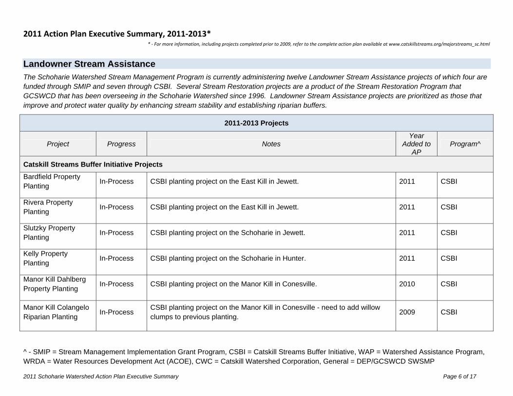
Landowner Stream Assistance The Schoharie Watershed Stream Management Program is currently administering twelve Landowner Stream Assistance projects of which four are funded through SMIP and seven through CSBI. Several Stream Restoration projects are a product of the Stream Restoration Program that GCSWCD that has been overseeing in the Schoharie Watershed since 1996. Landowner Stream Assistance projects are prioritized as those that improve and protect water quality by enhancing stream stability and establishing riparian buffers.
2011-2013 Projects
Project Progress Notes Year
Added to AP
Program^
Catskill Streams Buffer Initiative Projects Bardfield Property Planting
In-Process CSBI planting project on the East Kill in Jewett. 2011 CSBI
Rivera Property Planting
In-Process CSBI planting project on the East Kill in Jewett. 2011 CSBI
Slutzky Property Planting
In-Process CSBI planting project on the Schoharie in Jewett. 2011 CSBI
Kelly Property Planting
In-Process CSBI planting project on the Schoharie in Hunter. 2011 CSBI
Manor Kill Dahlberg Property Planting
In-Process CSBI planting project on the Manor Kill in Conesville. 2010 CSBI
Manor Kill Colangelo Riparian Planting
In-Process CSBI planting project on the Manor Kill in Conesville - need to add willow clumps to previous planting.
2009 CSBI
2011 Action Plan Executive Summary, 2011‐2013* * ‐ For more information, including projects completed prior to 2009, refer to the complete action plan available at www.catskillstreams.org/majorstreams_sc.html
^ - SMIP = Stream Management Implementation Grant Program, CSBI = Catskill Streams Buffer Initiative, WAP = Watershed Assistance Program, WRDA = Water Resources Development Act (ACOE), CWC = Catskill Watershed Corporation, General = DEP/GCSWCD SWSMP
2011 Schoharie Watershed Action Plan Executive Summary Page 7 of 17
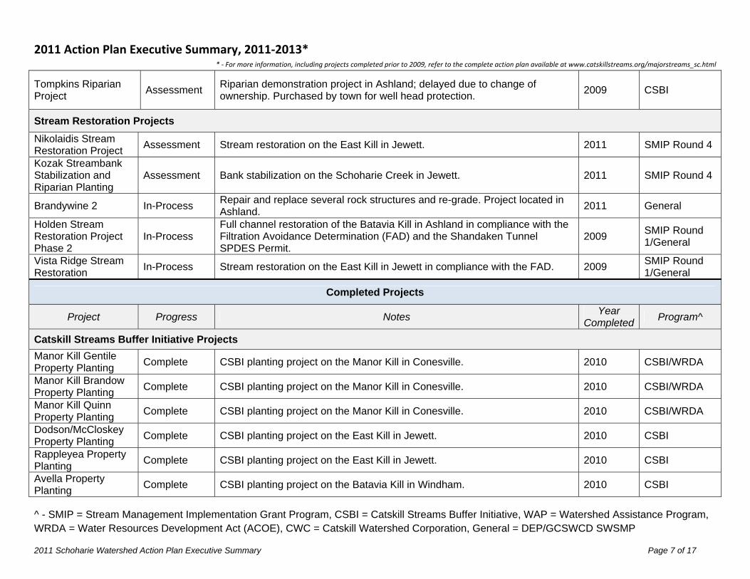
Tompkins Riparian Project
Assessment Riparian demonstration project in Ashland; delayed due to change of ownership. Purchased by town for well head protection.
2009 CSBI
Stream Restoration Projects Nikolaidis Stream Restoration Project
Assessment Stream restoration on the East Kill in Jewett. 2011 SMIP Round 4
Kozak Streambank Stabilization and Riparian Planting
Assessment Bank stabilization on the Schoharie Creek in Jewett. 2011 SMIP Round 4
Brandywine 2 In-Process Repair and replace several rock structures and re-grade. Project located in Ashland.
2011 General
Holden Stream Restoration Project Phase 2
In-Process Full channel restoration of the Batavia Kill in Ashland in compliance with the Filtration Avoidance Determination (FAD) and the Shandaken Tunnel SPDES Permit.
2009 SMIP Round 1/General
Vista Ridge Stream Restoration
In-Process Stream restoration on the East Kill in Jewett in compliance with the FAD. 2009 SMIP Round 1/General
Completed Projects
Project Progress Notes Year
CompletedProgram^
Catskill Streams Buffer Initiative Projects
Manor Kill Gentile Property Planting
Complete CSBI planting project on the Manor Kill in Conesville. 2010 CSBI/WRDA
Manor Kill Brandow Property Planting
Complete CSBI planting project on the Manor Kill in Conesville. 2010 CSBI/WRDA
Manor Kill Quinn Property Planting
Complete CSBI planting project on the Manor Kill in Conesville. 2010 CSBI/WRDA
Dodson/McCloskey Property Planting
Complete CSBI planting project on the East Kill in Jewett. 2010 CSBI
Rappleyea Property Planting
Complete CSBI planting project on the East Kill in Jewett. 2010 CSBI
Avella Property Planting
Complete CSBI planting project on the Batavia Kill in Windham. 2010 CSBI
2011 Action Plan Executive Summary, 2011‐2013* * ‐ For more information, including projects completed prior to 2009, refer to the complete action plan available at www.catskillstreams.org/majorstreams_sc.html
^ - SMIP = Stream Management Implementation Grant Program, CSBI = Catskill Streams Buffer Initiative, WAP = Watershed Assistance Program, WRDA = Water Resources Development Act (ACOE), CWC = Catskill Watershed Corporation, General = DEP/GCSWCD SWSMP
2011 Schoharie Watershed Action Plan Executive Summary Page 8 of 17
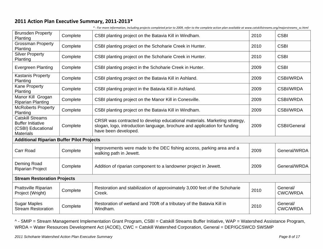
Brunsden Property Planting
Complete CSBI planting project on the Batavia Kill in Windham. 2010 CSBI
Grossman Property Planting
Complete CSBI planting project on the Schoharie Creek in Hunter. 2010 CSBI
Silver Property Planting
Complete CSBI planting project on the Schoharie Creek in Hunter. 2010 CSBI
Evergreen Planting Complete CSBI planting project in the Schoharie Creek in Hunter. 2009 CSBI
Kastanis Property Planting
Complete CSBI planting project on the Batavia Kill in Ashland. 2009 CSBI/WRDA
Kane Property Planting
Complete CSBI planting project in the Batavia Kill in Ashland. 2009 CSBI/WRDA
Manor Kill Grogan Riparian Planting
Complete CSBI planting project on the Manor Kill in Conesville. 2009 CSBI/WRDA
McRoberts Property Planting
Complete CSBI planting project on the Batavia Kill in Windham. 2009 CSBI/WRDA
Catskill Streams Buffer Initiative (CSBI) Educational Materials
Complete CRSR was contracted to develop educational materials. Marketing strategy, slogan, logo, introduction language, brochure and application for funding have been developed.
2009 CSBI/General
Additional Riparian Buffer Pilot Projects
Carr Road Complete Improvements were made to the DEC fishing access, parking area and a walking path in Jewett.
2009 General/WRDA
Deming Road Riparian Project
Complete Addition of riparian component to a landowner project in Jewett. 2009 General/WRDA
Stream Restoration Projects
Prattsville Riparian Project (Wright)
Complete Restoration and stabilization of approximately 3,000 feet of the Schoharie Creek.
2010 General/ CWC/WRDA
Sugar Maples Stream Restoration
Complete Restoration of wetland and 700ft of a tributary of the Batavia Kill in Windham.
2010 General/ CWC/WRDA
2011 Action Plan Executive Summary, 2011‐2013* * ‐ For more information, including projects completed prior to 2009, refer to the complete action plan available at www.catskillstreams.org/majorstreams_sc.html
^ - SMIP = Stream Management Implementation Grant Program, CSBI = Catskill Streams Buffer Initiative, WAP = Watershed Assistance Program, WRDA = Water Resources Development Act (ACOE), CWC = Catskill Watershed Corporation, General = DEP/GCSWCD SWSMP
2011 Schoharie Watershed Action Plan Executive Summary Page 9 of 17
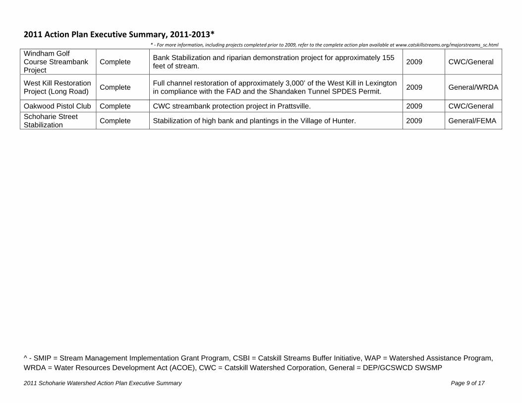
Windham Golf Course Streambank Project
Complete Bank Stabilization and riparian demonstration project for approximately 155 feet of stream.
2009 CWC/General
West Kill Restoration Project (Long Road)
Complete Full channel restoration of approximately 3,000’ of the West Kill in Lexington in compliance with the FAD and the Shandaken Tunnel SPDES Permit.
2009 General/WRDA
Oakwood Pistol Club Complete CWC streambank protection project in Prattsville. 2009 CWC/General
Schoharie Street Stabilization
Complete Stabilization of high bank and plantings in the Village of Hunter. 2009 General/FEMA
2011 Action Plan Executive Summary, 2011‐2013* * ‐ For more information, including projects completed prior to 2009, refer to the complete action plan available at www.catskillstreams.org/majorstreams_sc.html
^ - SMIP = Stream Management Implementation Grant Program, CSBI = Catskill Streams Buffer Initiative, WAP = Watershed Assistance Program, WRDA = Water Resources Development Act (ACOE), CWC = Catskill Watershed Corporation, General = DEP/GCSWCD SWSMP
2011 Schoharie Watershed Action Plan Executive Summary Page 10 of 17
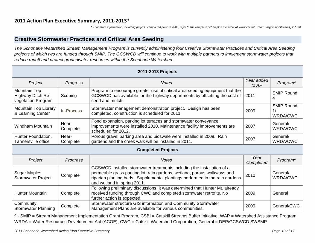
Creative Stormwater Practices and Critical Area Seeding The Schoharie Watershed Stream Management Program is currently administering four Creative Stormwater Practices and Critical Area Seeding projects of which two are funded through SMIP. The GCSWCD will continue to work with multiple partners to implement stormwater projects that reduce runoff and protect groundwater resources within the Schoharie Watershed.
2011-2013 Projects
Project Progress Notes Year added
to AP Program^
Mountain Top Highway Ditch Re-vegetation Program
Scoping Program to encourage greater use of critical area seeding equipment that the GCSWCD has available for the highway departments by offsetting the cost of seed and mulch.
2011 SMIP Round 4
Mountain Top Library & Learning Center
In-Process Stormwater management demonstration project. Design has been completed, construction is scheduled for 2011.
2009 SMIP Round 1/ WRDA/CWC
Windham Mountain Near-Complete
Pond expansion, parking lot terraces and stormwater conveyance improvements were installed 2010. Maintenance facility improvements are scheduled for 2012.
2007 General/ WRDA/CWC
Hunter Foundation, Tannersville office
Near-Complete
Porous gravel parking area and bioswale were installed in 2009. Rain gardens and the creek walk will be installed in 2011.
2007 General/ WRDA/CWC
Completed Projects
Project Progress Notes Year
Completed Program^
Sugar Maples Stormwater Project
Complete
GCSWCD installed stormwater treatments including the installation of a permeable grass parking lot, rain gardens, wetland, porous walkways and riparian planting beds. Supplemental plantings performed in the rain gardens and wetland in spring 2011.
2010 General/ WRDA/CWC
Hunter Mountain Complete Following preliminary discussions, it was determined that Hunter Mt. already received funding through CWC and completed stormwater retrofits. No further action is expected.
2009 General
Community Stormwater Planning
Complete Stormwater structure GIS information and Community Stormwater Management Plans are available for various communities.
2009 General/CWC
2011 Action Plan Executive Summary, 2011‐2013* * ‐ For more information, including projects completed prior to 2009, refer to the complete action plan available at www.catskillstreams.org/majorstreams_sc.html
^ - SMIP = Stream Management Implementation Grant Program, CSBI = Catskill Streams Buffer Initiative, WAP = Watershed Assistance Program, WRDA = Water Resources Development Act (ACOE), CWC = Catskill Watershed Corporation, General = DEP/GCSWCD SWSMP
2011 Schoharie Watershed Action Plan Executive Summary Page 11 of 17
Highway and Infrastructure Improvements The Schoharie Watershed Stream Management Program is currently administering nine Highway and Infrastructure Improvement projects of which seven are funded through SMIP. Proper highway and infrastructure management are a vital component to managing streams for natural stability and ecologic integrity. It was observed that a number of recommended actions would provide water quality enhancement or protection such as properly sizing culverts to reduce flooding and increase stream stability both up and downstream, and minimizing the introduction of road abrasives. Culverts addressed through this program must pose a threat to water quality to be eligible for funding.
2011-2013 Projects
Project Progress Notes Year
added to AP
Program^
Glen Avenue Culvert Upgrade
Contracting GCSWCD will work with the Village of Hunter Highway Department to design a properly sized culvert with a buried bottom for improved conveyance, stream stability and habitat enhancement and oversee the installation.
2011 SMIP Round 4
County Route 6 Slope Failure
In-Process Project involves the stabilization of a slope failure along CR6 and the West Kill in the Town of Lexington.
2011 SMIP Round 4
Cranberry Road Culvert Upgrade
In-Process GCSWCD will work with the Town of Hunter Highway Department to design a properly sized culvert with a buried bottom for improved conveyance, stream stability and habitat enhancement and oversee the installation.
2011 SMIP Round 3
Schoharie Watershed Stream Crossing/Culvert Design
In-Process $50,000 to be set aside for engineered design services on retainer to work with towns to ensure prioritized culverts are designed properly.
2010 SMIP Round 3
Mitchell Hollow Rd (CR 21) Stormwater Upgrade
In-Process
370’ of stormwater conveyance with catch basins and sumps will be installed along Mitchell Hollow Rd. to mitigate stormwater flooding in area along NYS Route 23 and will be treated for water quality by the creation of a filtering wetland.
2010 SMIP Round 3
Flood Response In-Process A Critical Response Plan is being developed for a culvert replacement along Griffin Road in the Town of Jewett.
2010 General
Street Sweeper with Vacuum
Pending CWC application submitted with SMIP funds providing the cost share match. On CWC wait list.
2009 SMIPRound1/ CWC
2011 Action Plan Executive Summary, 2011‐2013* * ‐ For more information, including projects completed prior to 2009, refer to the complete action plan available at www.catskillstreams.org/majorstreams_sc.html
^ - SMIP = Stream Management Implementation Grant Program, CSBI = Catskill Streams Buffer Initiative, WAP = Watershed Assistance Program, WRDA = Water Resources Development Act (ACOE), CWC = Catskill Watershed Corporation, General = DEP/GCSWCD SWSMP
2011 Schoharie Watershed Action Plan Executive Summary Page 12 of 17
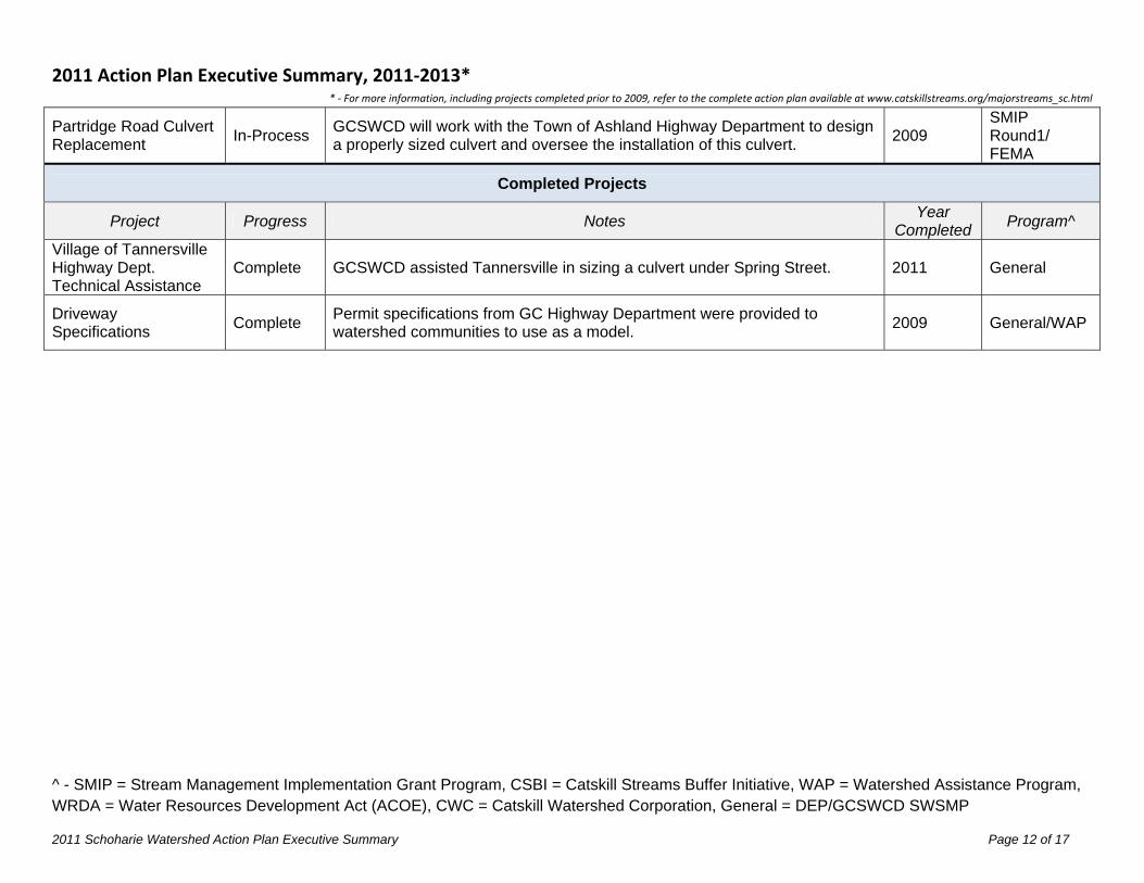
Partridge Road Culvert Replacement
In-Process GCSWCD will work with the Town of Ashland Highway Department to design a properly sized culvert and oversee the installation of this culvert.
2009 SMIP Round1/ FEMA
Completed Projects
Project Progress Notes Year
Completed Program^
Village of Tannersville Highway Dept. Technical Assistance
Complete GCSWCD assisted Tannersville in sizing a culvert under Spring Street. 2011 General
Driveway Specifications
Complete Permit specifications from GC Highway Department were provided to watershed communities to use as a model.
2009 General/WAP
2011 Action Plan Executive Summary, 2011‐2013* * ‐ For more information, including projects completed prior to 2009, refer to the complete action plan available at www.catskillstreams.org/majorstreams_sc.html
^ - SMIP = Stream Management Implementation Grant Program, CSBI = Catskill Streams Buffer Initiative, WAP = Watershed Assistance Program, WRDA = Water Resources Development Act (ACOE), CWC = Catskill Watershed Corporation, General = DEP/GCSWCD SWSMP
2011 Schoharie Watershed Action Plan Executive Summary Page 13 of 17
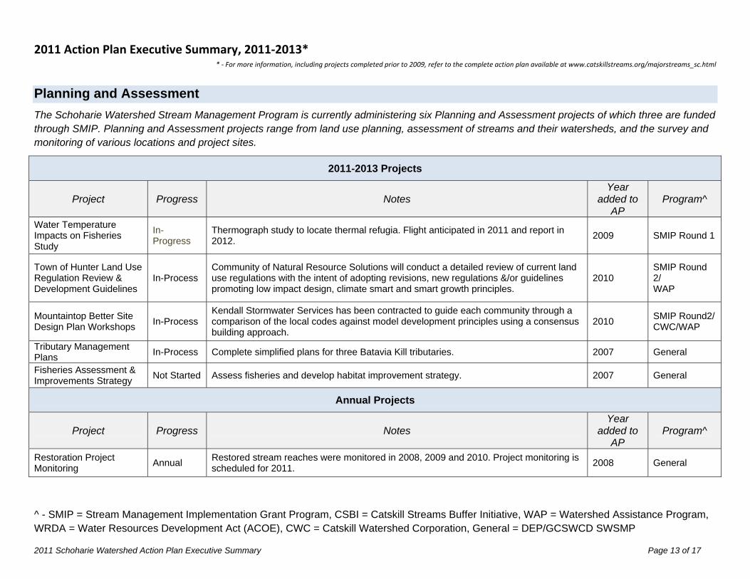
Planning and Assessment The Schoharie Watershed Stream Management Program is currently administering six Planning and Assessment projects of which three are funded through SMIP. Planning and Assessment projects range from land use planning, assessment of streams and their watersheds, and the survey and monitoring of various locations and project sites.
2011-2013 Projects
Project Progress Notes Year
added to AP
Program^
Water Temperature Impacts on Fisheries Study
In-Progress
Thermograph study to locate thermal refugia. Flight anticipated in 2011 and report in 2012.
2009 SMIP Round 1
Town of Hunter Land Use Regulation Review & Development Guidelines
In-Process Community of Natural Resource Solutions will conduct a detailed review of current land use regulations with the intent of adopting revisions, new regulations &/or guidelines promoting low impact design, climate smart and smart growth principles.
2010 SMIP Round 2/ WAP
Mountaintop Better Site Design Plan Workshops
In-Process Kendall Stormwater Services has been contracted to guide each community through a comparison of the local codes against model development principles using a consensus building approach.
2010 SMIP Round2/ CWC/WAP
Tributary Management Plans
In-Process Complete simplified plans for three Batavia Kill tributaries. 2007 General
Fisheries Assessment & Improvements Strategy
Not Started Assess fisheries and develop habitat improvement strategy. 2007 General
Annual Projects
Project Progress Notes Year
added to AP
Program^
Restoration Project Monitoring
Annual Restored stream reaches were monitored in 2008, 2009 and 2010. Project monitoring is scheduled for 2011.
2008 General
2011 Action Plan Executive Summary, 2011‐2013* * ‐ For more information, including projects completed prior to 2009, refer to the complete action plan available at www.catskillstreams.org/majorstreams_sc.html
^ - SMIP = Stream Management Implementation Grant Program, CSBI = Catskill Streams Buffer Initiative, WAP = Watershed Assistance Program, WRDA = Water Resources Development Act (ACOE), CWC = Catskill Watershed Corporation, General = DEP/GCSWCD SWSMP
2011 Schoharie Watershed Action Plan Executive Summary Page 14 of 17
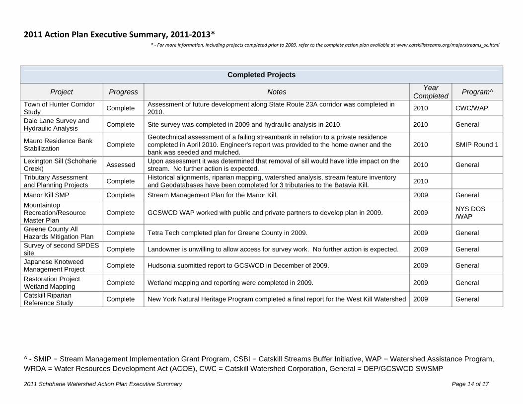
Completed Projects
Project Progress Notes Year
CompletedProgram^
Town of Hunter Corridor Study
Complete Assessment of future development along State Route 23A corridor was completed in 2010.
2010 CWC/WAP
Dale Lane Survey and Hydraulic Analysis
Complete Site survey was completed in 2009 and hydraulic analysis in 2010. 2010 General
Mauro Residence Bank Stabilization
Complete Geotechnical assessment of a failing streambank in relation to a private residence completed in April 2010. Engineer's report was provided to the home owner and the bank was seeded and mulched.
2010 SMIP Round 1
Lexington Sill (Schoharie Creek)
Assessed Upon assessment it was determined that removal of sill would have little impact on the stream. No further action is expected.
2010 General
Tributary Assessment and Planning Projects
Complete Historical alignments, riparian mapping, watershed analysis, stream feature inventory and Geodatabases have been completed for 3 tributaries to the Batavia Kill.
2010
Manor Kill SMP Complete Stream Management Plan for the Manor Kill. 2009 General
Mountaintop Recreation/Resource Master Plan
Complete GCSWCD WAP worked with public and private partners to develop plan in 2009. 2009 NYS DOS /WAP
Greene County All Hazards Mitigation Plan
Complete Tetra Tech completed plan for Greene County in 2009. 2009 General
Survey of second SPDES site
Complete Landowner is unwilling to allow access for survey work. No further action is expected. 2009 General
Japanese Knotweed Management Project
Complete Hudsonia submitted report to GCSWCD in December of 2009. 2009 General
Restoration Project Wetland Mapping
Complete Wetland mapping and reporting were completed in 2009. 2009 General
Catskill Riparian Reference Study
Complete New York Natural Heritage Program completed a final report for the West Kill Watershed 2009 General
2011 Action Plan Executive Summary, 2011‐2013* * ‐ For more information, including projects completed prior to 2009, refer to the complete action plan available at www.catskillstreams.org/majorstreams_sc.html
^ - SMIP = Stream Management Implementation Grant Program, CSBI = Catskill Streams Buffer Initiative, WAP = Watershed Assistance Program, WRDA = Water Resources Development Act (ACOE), CWC = Catskill Watershed Corporation, General = DEP/GCSWCD SWSMP
2011 Schoharie Watershed Action Plan Executive Summary Page 15 of 17
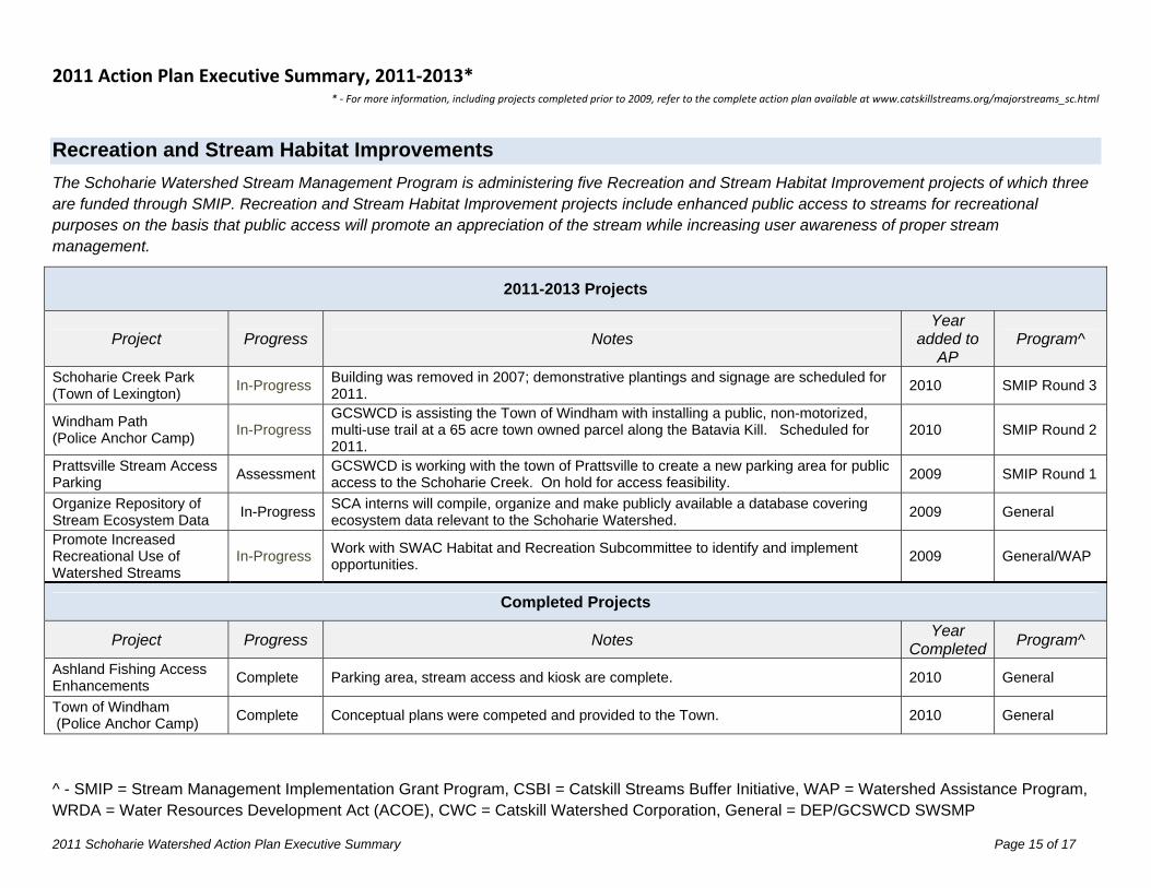
Recreation and Stream Habitat Improvements The Schoharie Watershed Stream Management Program is administering five Recreation and Stream Habitat Improvement projects of which three are funded through SMIP. Recreation and Stream Habitat Improvement projects include enhanced public access to streams for recreational purposes on the basis that public access will promote an appreciation of the stream while increasing user awareness of proper stream management.
2011-2013 Projects
Project Progress Notes Year
added to AP
Program^
Schoharie Creek Park (Town of Lexington)
In-Progress Building was removed in 2007; demonstrative plantings and signage are scheduled for 2011.
2010 SMIP Round 3
Windham Path (Police Anchor Camp)
In-Progress GCSWCD is assisting the Town of Windham with installing a public, non-motorized, multi-use trail at a 65 acre town owned parcel along the Batavia Kill. Scheduled for 2011.
2010 SMIP Round 2
Prattsville Stream Access Parking
Assessment GCSWCD is working with the town of Prattsville to create a new parking area for public access to the Schoharie Creek. On hold for access feasibility.
2009 SMIP Round 1
Organize Repository of Stream Ecosystem Data
In-Progress SCA interns will compile, organize and make publicly available a database covering ecosystem data relevant to the Schoharie Watershed.
2009 General
Promote Increased Recreational Use of Watershed Streams
In-Progress Work with SWAC Habitat and Recreation Subcommittee to identify and implement opportunities.
2009 General/WAP
Completed Projects
Project Progress Notes Year
CompletedProgram^
Ashland Fishing Access Enhancements
Complete Parking area, stream access and kiosk are complete. 2010 General
Town of Windham (Police Anchor Camp)
Complete Conceptual plans were competed and provided to the Town. 2010 General
2011 Action Plan Executive Summary, 2011‐2013* * ‐ For more information, including projects completed prior to 2009, refer to the complete action plan available at www.catskillstreams.org/majorstreams_sc.html
^ - SMIP = Stream Management Implementation Grant Program, CSBI = Catskill Streams Buffer Initiative, WAP = Watershed Assistance Program, WRDA = Water Resources Development Act (ACOE), CWC = Catskill Watershed Corporation, General = DEP/GCSWCD SWSMP
2011 Schoharie Watershed Action Plan Executive Summary Page 16 of 17
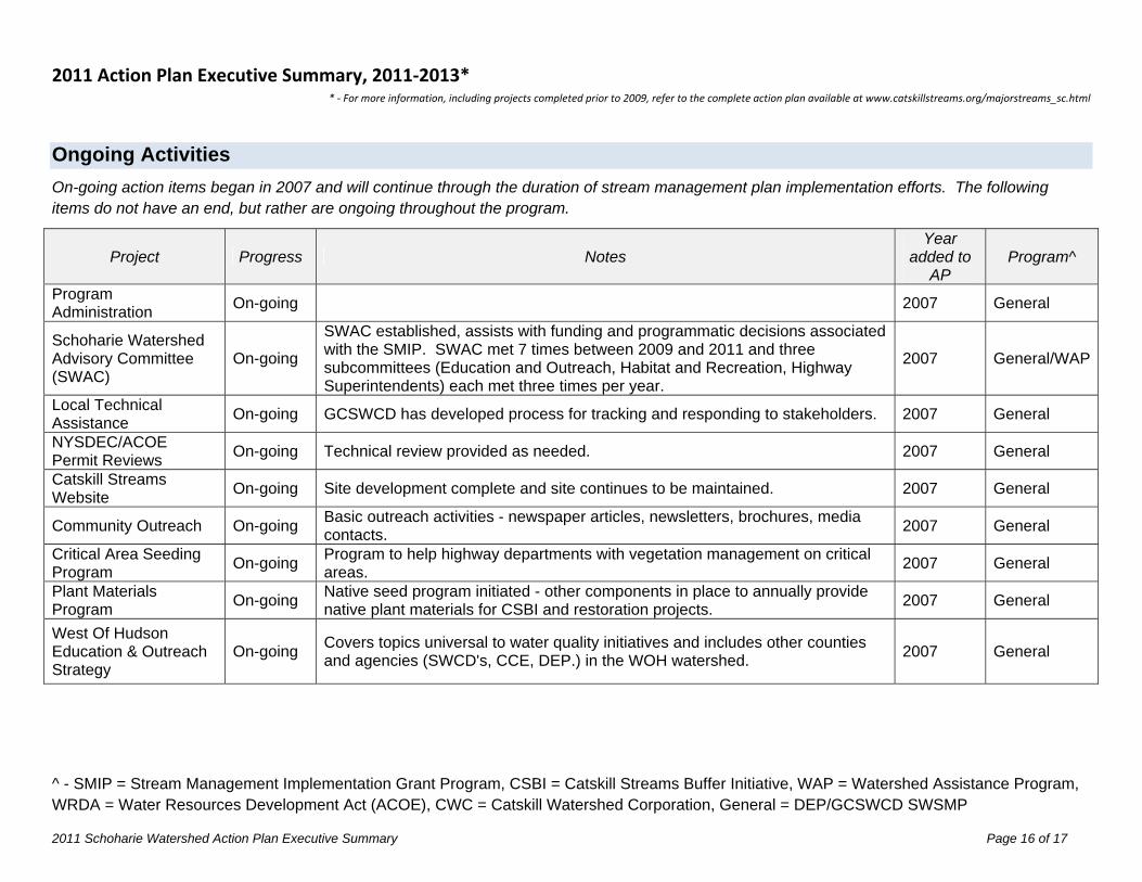
Ongoing Activities On-going action items began in 2007 and will continue through the duration of stream management plan implementation efforts. The following items do not have an end, but rather are ongoing throughout the program.
Project Progress Notes Year
added to AP
Program^
Program Administration
On-going 2007 General
Schoharie Watershed Advisory Committee (SWAC)
On-going
SWAC established, assists with funding and programmatic decisions associated with the SMIP. SWAC met 7 times between 2009 and 2011 and three subcommittees (Education and Outreach, Habitat and Recreation, Highway Superintendents) each met three times per year.
2007 General/WAP
Local Technical Assistance
On-going GCSWCD has developed process for tracking and responding to stakeholders. 2007 General
NYSDEC/ACOE Permit Reviews
On-going Technical review provided as needed. 2007 General
Catskill Streams Website
On-going Site development complete and site continues to be maintained. 2007 General
Community Outreach On-going Basic outreach activities - newspaper articles, newsletters, brochures, media contacts.
2007 General
Critical Area Seeding Program
On-going Program to help highway departments with vegetation management on critical areas.
2007 General
Plant Materials Program
On-going Native seed program initiated - other components in place to annually provide native plant materials for CSBI and restoration projects.
2007 General
West Of Hudson Education & Outreach Strategy
On-going Covers topics universal to water quality initiatives and includes other counties and agencies (SWCD's, CCE, DEP.) in the WOH watershed.
2007 General
Section 2. Schoharie Basin Stream Management Program
Action Plan 2011-2013
May 15, 2011
NYCDEP Stream Management Program 71 Smith Ave, Kingston NY 12401
Dave Burns, Project Manager 845.340.7850
Greene County Soil & Water Conservation District
907 County Office Building, Cairo NY 12413 Jeff Flack, Executive Director
518.622.3620 [email protected]
Section 2. Schoharie Basin Action Plan, 2011-2013 Page 1 of 24
Greene County Soil & Water Conservation District
907 County Office Building, Cairo NY 12413 Jeff Flack, Executive Director
518.622.3620 [email protected]
TABLE OF CONTENTS I. Education on Watershed Protection
A. Organize a Schoharie Watershed Month B. Batavia Kill Stream Celebration C. Schoharie Watershed Summit D. Schoharie Watershed Tour E. Mountain Top Arboretum Outdoor Classroom F. Environmental Film Series G. Roadside Ditch Maintenance Workshop H. Riparian Buffer Workshop I. Water Quality at Home Workshops J. Schoharie Watershed Stream Crossing Workshop K. CD Lane Family Day L. Manor Kill Information Kiosk M. Manor Kill Environmental Study Team N. Identify Existing Resources O. Complete Kiosk Series
II. Landowner Stream Assistance A. Catskill Streams Buffer Initiative B. Stream Restoration Projects & Modifications
III. Creative Stormwater Practices and Critical Area Seeding A. Mountain Top Highway Ditch Re-vegetation Program B. Mountain Top Library & Learning Center C. Windham Mountain D. Hunter Foundation
IV. Highway and Infrastructure Improvements A. Glen Avenue Culvert Upgrade B. County Route 6 Slope Failure C. Cranberry Road Culvert Upgrade
D. Schoharie Watershed Stream Crossing/Culvert Design E. Mitchell Hollow Rd (CR 21) Stormwater Sewer Upgrade F. Flood Response G. Street Sweeper with Vacuum H. Partridge Road Culvert Replacement
V. Planning and Assessment A. Town of Hunter Land Use Regulation Review
B. Mountaintop Better Site Design Plan Workshops C. Tributary Stream Inventory and Assessment D. Fisheries Assessment & Improvements Strategy E. Project Monitoring
F. Water Temperature Impacts on Fisheries Study VI. Recreation and Stream Habitat Improvements A. Schoharie Creek Park B. Windham Path C. Prattsville Stream Access Parking D. Organize Repository of Stream Ecosystem Data E. Promote Increased Recreational Use of Watershed Streams VII. On-going Activities
A. Program Administration and Implementation B. Local Technical Assistance C. Inter-Agency Coordination D. Catskill Streams Website E. Community Outreach F. Critical Area Seeding Program G. Plant Materials Program H. WOH Education & Outreach Strategy
NYCDEP Stream Management Program 71 Smith Ave, Kingston NY 12401 Dave Burns, Project Coordinator
845.340.7850 [email protected]
Section 2. Schoharie Basin Action Plan, 2011-2013 Page 2 of 24
Schoharie Basin Stream Management Program
Action Plan 2011 – 2013 Updated May 15, 2011
The Schoharie Watershed Stream Management Program (SWSMP) was established in partnership with the Greene County Soil & Water Conservation District (GCSWCD) and NYC Department of Environmental Protection (DEP) in 1997 as part of the Filtration Avoidance Determination (FAD) issued to DEP by the Environmental Protection Agency. Stream Management Plans have been completed for each major river corridor in the Schoharie Watershed and each plan includes a set of general recommendations, and project specific recommendations, which provide a “road map” for improved stream and floodplain management. In addition to supporting the FAD, many SWSMP projects also target reductions to in-stream sources of suspended sediments as part of DEP’s Shandaken Tunnel State Pollution Discharge Elimination System (SPEDES) permit established in September 2006. The SWSMP seeks to advance state-of-the-art watershed management projects, policies and programs to improve and protect the Schoharie’s water resources. Initiatives include the Stream Management Implementation Program (SMIP), the Catskill Streams Buffer Initiative (CSBI), Stream and Floodplain Restoration Projects, Stream and Watershed Assessments, and Education and Outreach programs. The following Action Plan summarizes the programs and projects that GCSWCD will be leading within the Schoharie Basin between May 2011 and May 2013. The GCSWCD will lead the efforts for each action item, and work cooperatively with watershed partners including, but not limited to, the Schoharie Watershed Advisory Committee (SWAC), NYCDEP, NYSDEC, CWC and watershed municipalities. The Action Plan is one piece of a three-part package that includes: this action plan, an executive summary and a completed projects synopsis. This is a dynamic document that will be updated annually. Funding sources are presented with the following acronyms: Stream Management Implementation Grant Program (SMIP), Catskill Streams Buffer Initiative (CSBI), Watershed Assistance Program (WAP), Water Resources Development Act (WRDA), Catskill Watershed Corporation (CWC), DEP/GCSWCD Schoharie Watershed Stream Management Program (Contract).
I. Education on Watershed Protection: The GCSWCD works with a wide network of partners to enhance its education and outreach efforts related to stream and floodplain management, sediment and erosion control, and other topics critical to sound watershed management. A priority goal of this action plan is to increase education and outreach activities. Many of the following E/O initiatives were developed by the SWAC E/O Subcommittee. Education and Outreach action items include, but are not limited to: A. Organize a Schoharie Watershed Month: Community involvement and awareness is important for promoting the protection of streams and their watersheds. Hosting a watershed-wide educational and recreational event (Schoharie Watershed Month) will provide an opportunity for watershed residents, students, community groups, tourists, officials, etc. to get to know their stream and the resources available to help provide watershed protection. GCSWCD Staff: Worcester, Yost Project Partners: Local schools and colleges, community organizations, CWC (Youth Summit Committee), CCCD, WAC, GCCCE, DEC, NYCDEP, SWAC Education and Outreach Subcommittee Project Funding: NYCDEP/GCSWCD Schoharie SMP Contract, CWC, GCSWCD-WAP, local sponsors, chambers of commerce
Project Schedule: Organize annually from January through May; event held annually in May. SMP Recommendation: Schoharie/East Kill – Education and Outreach 6.4.8; Manor Kill- Education and Outreach 5.4.8
Date Added to Action Plan: 2009 Progress: The first Annual Schoharie Watershed Week was held May 17-23rd, 2010. A number of events were scheduled during the week to educate and engage local community members (full time and seasonal residents, tourists, business community) in watershed programs and stewardship activities. At a post-event scoping meeting in June 2010 it was decided that the week should be expanded to the entire month of May—Schoharie Watershed Month—in order spread activities across the entire month and focus more on weekends to capture more visitors and residents. The
Section 2. Schoharie Basin Action Plan, 2011-2013 Page 3 of 24
2011 Schoharie Watershed Month will take place during May 2011, and will involve hands-on workshops, stream clean ups, riparian buffer plantings, an Environmental Film Series, and other fun educational, hands-on activities. For more information: http://www.gcswcd.com/swp/eo/swmswm.
B. Batavia Kill Stream Celebration: The Batavia Kill Stream Celebration is held annually in August. The family-oriented event has music, displays, and educational activities and interactive programs that celebrate the Batavia Kill and water resources. For more information: http://www.gcswcd.com/swpswp/eo/bkscbksc.
GCSWCD Staff: Yost, Worcester Project Partners: NYCDEP, GCSWCD, Ashland, CWC, SWAC Project Funding: NYCDEP, GCSWCD, Town of Ashland, CWC, WAC, MSMA, many local business sponsors Project Schedule: Organize from February through August; event held annually in August. SMP Recommendation: Schoharie -- Education and Outreach 6.4
Date Added to Action Plan: 2009 Progress: The 3rd and 4th Annual Batavia Kill Stream Celebrations were held August 1, 2009 and August 7, 2010 respectively. The 4th Annual Batavia Kill Stream Celebration showcased the talents of Arm-of-the-Sea Theater, Mike Ryan, Jim Planck, and provided many fun educational activities focused on water resources including a wide array of government and non-profit agencies working in the basin on watershed management. The event was a huge success with attendance at an all-time high and people traveling from all over the region. New activities were added including Watershed Minutes, mini-lectures on the NYC Watershed and resources, and honoring landowners for their participation in stream restoration projects. The Stream Stewardship Award Ceremony was a highlight to the day with DEP Deputy Commissioner Paul Rush and NYS Assemblyman Peter Lopez recognizing the vital role landowners bring to maintaining stable streams. Each Steward received a Certificate for their participation in the SMP. The 5th Annual Batavia Kill Stream Celebration is planned for August 6, 2011.
C. Schoharie Watershed Summit: The annual conference, which began in 2007, is organized for local municipal officials, county and non-profit agencies, highway departments, regulatory and engineering firms active in the Schoharie basin, and offers training in relevant water resources management, regulations, land use, and stormwater management. Credits for planning board members are provided.
GCSWCD Staff: Yost, Worcester Project Partners: NYCDEP, GCSWCD, SWAC Project Funding: NYCDEP, GCSWCD Project Schedule: Organize from September through January; event held in annually in January. SMP Recommendation: Schoharie -- Education and Outreach 6.4
Date Added to Action Plan: 2009 Progress: The 3rd, 4th and 5th annual Watershed Summits were held January 24, 2009, January 23, 2010 and January 22 2011 respectively. The 2011 Schoharie Watershed Summit had approximately 110 watershed stakeholders attending; Don Lake, CPESC, was the keynote speaker. Afternoon breakout sessions offered training on mountaintop mapping, stormwater management, floodplain management, and available funding resources. The 6th annual Schoharie Watershed Summit is planned for January 2012.
D. Schoharie Watershed Tour: The annual Watershed tours are organized to provide public officials, watershed managers and landowners an opportunity to view project sites to see the range and diversity of potential watershed projects. The Watershed tours offer training in relevant water resource issues and management. For more information: http://www.gcswcd.com/swp/eo/sw-tour.
GCSWCD Staff: Yost, Worcester Project Partners: NYCDEP, GCSWCD, SWAC Project Funding: NYCDEP, GCSWCD Project Schedule: Organize from February through June; event held annually in June. SMP Recommendation: Schoharie -- Education and Outreach 6.4
Section 2. Schoharie Basin Action Plan, 2011-2013 Page 4 of 24
Date Added to Action Plan: 2009 Progress: The 3rd and 4th annual Schoharie Watershed Tours were held June 20, 2009 and June 19, 2010 respectively. The 2010 Schoharie Watershed Tour had approximately 45 people in attendance. The tour offered an opportunity for community residents, officials and county support staff to learn about the effects of climate change and invasive species on the Catskills, and see firsthand alternative energy and pollution mitigation work that is being done at the Hunter Landfill. After the morning discussions, attendees were treated to a tour of the Hunter Landfill wetland system and wind turbine, to illustrate the benefits of constructed wetlands and the connections between renewable energy and water quality. The 2011 Schoharie Watershed Tour is being planned for June 2011 and is anticipated to highlight the recently-completed Phase I of the Windham Mountain Stormwater Retrofit Project.
E. Mountain Top Arboretum Outdoor Classroom Construction: Construct an accessible outdoor classroom that would accommodate approximately 45 people for year-round outdoor programming on a range of ecological and natural history topics relating to the watershed. Design plans and bid specifications for the classroom construction were developed through SMIP Round 2.
GCSWCD Staff: Worcester, Yost Project Partners: Mountain Top Arboretum Project Funding: SMIP Round 4 Project Schedule: Contract period - 2011-2013. SMP Recommendation: Schoharie -- Education and Outreach 6.4
Date Added to Action Plan: 2011 Progress: Awarded SWAC SMIP funding in March, 2011. SMIP funding for a design plan was awarded in March of 2010; design plan was completed in the summer of 2010.
F. Environmental Film Series: The WAC proposes hosting an environmental film series at the Doctorow Center in Hunter on two nights during Schoharie Watershed Month (May). The films would be water-focused and highlight watershed issues, pollution mitigation, or watershed, foodshed, viewshed topics. A post-screening discussion will be held after each movie.
GCSWCD Staff: Worcester, Yost Project Partners: Watershed Agricultural Council, GCSWCD Project Funding: SMIP Round 4 Project Schedule: Organize under Schoharie Watershed Month, 2011. SMP Recommendation: Schoharie -- Education and Outreach 6.4.8
Date Added to Action Plan: 2011 Progress: Awarded SWAC SMIP funding in March, 2011 G. Roadside Ditch Maintenance Workshop: Conduct a workshop for local highway departments on the importance of prioritizing ditch scraping and the different methods and materials available based on ditch conditions.
GCSWCD Staff: Worcester, Yost Project Partners: Local highway departments, Greene County Highway Dept., NYCDEP Project Funding: SMIP Round 4 – Prerequisite of culvert SMIP grant – Section IV(D) Project Schedule: Educational workshop scheduled for June 2011 SMP Recommendation: Schoharie -- Water Quality 6.3.3; Education and Outreach 6.4
Date Added to Action Plan: 2011 Progress: Awarded SWAC SMIP funding in March, 2011
Section 2. Schoharie Basin Action Plan, 2011-2013 Page 5 of 24
H. Riparian Buffer Workshop: Conduct workshop for streamside landowners that highlight the importance of riparian buffers and demonstrate management practices to maintain healthy stream buffers.
GCSWCD Staff: Worcester, Weyeneth Project Partners: CSBI Project Funding: CSBI, NYCDEP/GCSWCD Schoharie SMP Contract Project Schedule: 2011 SMP Recommendation: Schoharie -- Education and Outreach 6.4.8
Date Added to Action Plan: 2011 Progress: Currently being organized
I. Water Quality at Home Workshops: Implement 3 action-based educational workshops that can be implemented at home as part of raising awareness about stewardship of water quality (will be part of Schoharie Watershed Month 2011) - building rain barrels, holistic pond management, and eco-landscaping (avoid use of chemicals).
GCSWCD Staff: Worcester, Yost Project Partners: Greene County Cornell Cooperative Extension Project Funding: SMIP Round 3 Project Schedule: May 2011. SMP Recommendation: Schoharie -- Education and Outreach 6.4.8
Date Added to Action Plan: 2011 Progress: Awarded SWAC SMIP funding in October 2010, agreements completed with GCSWCD, working on organizing workshops for May 2011. J. Schoharie Watershed Stream Crossing Workshop: Develop, design and implement a culvert workshop for local highway departments that highlights the importance of proper design & installation of culverts for sediment transport, fish passage and incorporates principals using natural channel design for long term stability, protection of water quality and health of streams.
GCSWCD Staff: Worcester, Yost Project Partners: Local highway departments, Greene County Highway Dept., NYCDEP, NYSDOT Project Funding: SMIP Round 3 Project Schedule: Fall 2011 organize one day workshop. SMP Recommendation: Schoharie -- Education and Outreach 6.4
Date Added to Action Plan: 2011 Progress: Awarded SWAC SMIP funding in October 2010, identifying potential presenters for Fall 2011 workshop.
K. CD Lane Family Day: Promote outdoor activities as part of CD Lane Family Day involving hands on experience with water activities (water quality testing, fly
fishing demos, canoe & kayak safety class, nature hike and crafts). To be conducted in conjunction with Schoharie Watershed Month 2011.
GCSWCD Staff: Worcester, Yost Project Partners: Community of Windham Foundation, SWAC Project Funding: SMIP Round 3 Project Schedule: Organize under Schoharie Watershed Month, 2011
Section 2. Schoharie Basin Action Plan, 2011-2013 Page 6 of 24
SMP Recommendation: Schoharie -- Education and Outreach 6.4.8 Date Added to Action Plan: 2011
Progress: Awarded SWAC SMIP funding in October 2010, activities being planned for Memorial Day Weekend, May 28, 2011.
L. Manor Kill Information Kiosk: Create a kiosk highlighting the Manor Kill, watershed protection efforts, and agencies and programs serving the area. Location would be in a popular public park, near a riparian planting project that took place in October 2008. Information will be changed and updated as warranted.
GCSWCD Staff: Nichols, Worcester Project Partners: SCSWCD, NYCDEP Project Funding: SMIP Round 2 Project Schedule: Contract period - 2010-2012. SMP Recommendation: Manor Kill -- Education and Outreach 5.4
Date Added to Action Plan: 2010 Progress: Kiosk provided to Conesville for continuity with Kiosk Series (see F above). Awarded SWAC SMIP funding in March, 2010. A general Schoharie Watershed/Schoharie SWCD panel was produced in conjunction with GCSWCD’s kiosk series and was received by GCSWCD in March 2011. This panel will be installed in spring/summer 2011 and a second panel highlighting the importance of riparian buffers will be developed and installed in 2011/2012.
M. Manor Kill Environmental Study Team/Stream Management Implementation: Conduct on-going implementation of Manor Kill Stream Management Plan by involving youth, and their families, in water quality monitoring and testing, taxonomy, riparian zone restoration, invasive species identification, and public outreach presentation skill building.
GCSWCD Staff: Worcester, Yost Project Partners: Schoharie River Center, SWAC Project Funding: SMIP Round 1 Project Schedule: Contract period - 2010-2012. SMP Recommendation: Manor Kill – Education and Outreach 5.4
Date Added to Action Plan: 2010 Progress Awarded SWAC SMIP funding in October, 2009; completed agreements with GCSWCD in early 2010; Schoharie River Center implementing education components with youth and families in learning about the Manor Kill and its resources.
N. Identify Existing Resources: In order to know where gaps exist and to target educational efforts, GCSWCD will identify and catalog existing resources that are currently available.
GCSWCD Staff: Worcester, Yost Project Partners: Agencies that provide watershed programming (CWC, GCCCE, CCCD, WAC, basin schools, DEC)
Project Funding: NYCDEP/GCSWCD Schoharie SMP Contract, CWC, GCSWCD-WAP, others Project Schedule: Fall/Winter, 2011 SMP Recommendation: Schoharie/East Kill – Education and Outreach 6.4.8
Date Added to Action Plan: 2009 Progress: The SWAC Education and Outreach Subcommittee provides the venue for all the education and outreach based organizations to gather, discuss and collaborate on programming. Web-based documentation of existing resources will be completed in 2011.
O. Complete Kiosk Series: Kiosks will be based upon categories of water resource-related best management practices.
Section 2. Schoharie Basin Action Plan, 2011-2013 Page 7 of 24
GCSWCD Staff: Worcester, Hellinga Project Partners: Organizations, property owners where kiosks will be located
Project Funding: NYCDEP/GCSWCD Schoharie SMP Contract Project Schedule: Complete installation in 2012. SMP Recommendation: Batavia Kill – Education and Outreach-08 (High, 2.27), 09 (Medium, 1.54), 06 (Medium, 1.15), 10 (Medium, 0);
Schoharie/East Kill – Education and Outreach-6.4.2, 6.4.3, 6.4.4, 6.4.5, 6.4.6, 6.4.7, 6.4.8; Flood Prevention-6.1.7 West Kill – Education and Outreach 6.4.3, 6.4.4, 6.4.5 Date Added to Action Plan: 2009
Progress: Three kiosks were constructed in 2009: one was installed at the Sugar Maples site and one was donated to Schoharie County SWCD for the Conesville Town Hall. An additional kiosk was constructed in fall of 2010 at the Ashland Connector Stream Restoration Project in conjunction with the construction of a public access parking area. The kiosk series highlights the various restoration projects throughout the Schoharie watershed. Kiosk display boards have been designed and purchased and will be installed at the Sugar Maples and Ashland Connector Reach kiosks in spring 2011. The remaining kiosk and signage will be installed in spring/summer 2012.
II. Landowner Stream Assistance The GCSWCD and NYCDEP recognize the importance of providing assistance to local landowners. The NYCDEP, GCSWCD and SCSWCD have provided the necessary training for project staff to be able to provide state-of-the-art technical assistance throughout the watershed. Technical assistance from staff members will guide the restoration of stream system stability and help to maintain ecological integrity. Technical assistance can range from a landowner consultation to activities that will help to meet the priorities of protecting water quality and establishing riparian buffers. Protection and enhancement of water quality can benefit both the City of New York’s water supply and the residents of the Schoharie basin. Landowner Stream Assistance action items include, but are not limited to: A. Catskill Streams Buffer Initiative: An effective riparian buffer program can assist landowners with their efforts to protect and maintain healthy riparian buffers, address invasive species, and improve the condition of unstable or degraded riparian areas. In 2009, the Catskill Streams Buffer Initiative was developed to educate and assist streamside landowners in order to provide for improved stewardship of riparian areas. The GCSWCD and NYCDEP will work with landowners to protect, enhance, manage and restore riparian buffers within the WOH watershed. GCSWCD staff will conduct site visits to determine eligibility for funding through the CSBI. In addition to site visits, recruitment may also include outreach mechanisms such as press releases, targeted mailings, presentations to organizations, and Riparian Corridor Management Plan development.
Catskill Streams Buffer Initiative Projects:
Site 1. Bardfield Property Planting: Catskill Streams Buffer Initiative - Obtain landowner agreement and restore approximately 29,750 square feet of streamside vegetation along the East Kill. GCSWCD Staff: Weyeneth, Truesdell Project Partners: NYCDEP, GCSWCD, Landowner Project Funding: CSBI Project Schedule: Build in 2011 SMP Recommendation: Schoharie/East Kill – Riparian Zone Management -6.7.1, 6.7.2, 6.7.4 Date Added to Action Plan: 2011 Progress: GCSWCD has a 5 year landowner agreement for this property. Riparian Corridor Management Plan is complete. Project includes the installation of 465 trees, shrubs, and willow stakes to create a 35 ft. wide riparian buffer along 850 ft. of the East Kill in the spring of 2011.
Section 2. Schoharie Basin Action Plan, 2011-2013 Page 8 of 24
Site 2. Rivera Property Planting: Catskill Streams Buffer Initiative - Obtain landowner agreement and restore approximately 32,000 square feet of streamside vegetation along the East Kill. GCSWCD Staff: Weyeneth, Truesdell Project Partners: NYCDEP, GCSWCD, Landowner Project Funding: CSBI Project Schedule: Build in 2011 SMP Recommendation: Schoharie/East Kill – Riparian Zone Management- 6.7.1, 6.7.2, 6.7.4 Date Added to Action Plan: 2011 Progress: GCSWCD has a 5 year landowner agreement for this property. Riparian Corridor Management Plan is complete. Project includes the installation of 514 trees and shrubs in the spring of 2011 in two separate planting areas along the East Kill. One planting area is 200’ by 50’. The other is 250’ by 90’. In addition, another 500’ of stream bank will be seeded with a riparian buffer mix and staked with willows. Site 3. Slutzky Property Planting: Catskill Streams Buffer Initiative - Obtain landowner agreement and restore approximately 95,000 square feet of streamside vegetation along the Schoharie. GCSWCD Staff: Weyeneth, Truesdell Project Partners: NYCDEP, GCSWCD, Landowner Project Funding: CSBI Project Schedule: Build in 2011 SMP Recommendation: Schoharie/East Kill – Riparian Zone Management- 6.7.1, 6.7.2, 6.7.3, 6.7.4, 6.7.6, 6.7.7, 6.7.8, 6.7.9, 6.7.10, 6.7.11, 6.7.12, 6.7.13; General Stream Management Activities- 6.8.2 Date Added to Action Plan 2011 Progress: GCSWCD has a 5 year landowner agreement for this property. Project includes the installation of 1,484 trees and shrubs in the spring of 2011 next to a parcel that was planted by GCSWCD in 2009.
Site 4. Kelly Property Planting: Catskill Streams Buffer Initiative - Obtain landowner agreement and restore approximately 6,250 square feet of streamside vegetation along the Schoharie Creek headwaters. GCSWCD Staff: Weyeneth, Truesdell Project Partners: NYCDEP, GCSWCD, Landowner Project Funding: CSBI Project Schedule: Build in 2011 SMP Recommendation: Schoharie/East Kill – Riparian Zone Management 6.7.1, 6.7.2, 6.7.4 Date Added to Action Plan: 2011 Progress: GCSWCD has a 10 year landowner agreement for this property. Riparian Corridor Management Plan is complete. Project includes the installation of 97 trees and shrubs along 250 ft. to create a 25 ft. riparian buffer in the spring of 2011. Site 5. Manor Kill Dahlberg Property Planting: Catskill Streams Buffer Initiative - Obtain landowner agreement, create property management plan and restore approximately 3,750 square feet of streamside vegetation along the Manor Kill. SCSWCD/GCSWCD Staff: Nichols, Weyeneth Project Partners: NYCDEP, GCSWCD, SCSWCD, Landowner Project Funding: CSBI Project Schedule: Build in 2011 SMP Recommendation: Manor Kill –Riparian Zone Management 5.7.1, 5.7.2, 5.7.4, 5.7.7
Section 2. Schoharie Basin Action Plan, 2011-2013 Page 9 of 24
Date Added to Action Plan 2010 Progress: Riparian Corridor Management Plan is complete. Planting will include the installation of a 25’ buffer along 150’ of the Manor Kill. Project will include vertical bundles along the toe of the bank and minor bank grading along approximately 75’ to accommodate additional plantings. Planting is scheduled for spring of 2011. Site 6. Manor Kill Colangelo Riparian Planting: SCSWCD/GCSWCD Staff: Nichols, Weyeneth Project Partners: NYCDEP, GCSWCD, SCSWCD, Community Volunteers Project Funding: CSBI Project Schedule: 2011 SMP Recommendation: Manor Kill – Riparian Zone Management 5.7.1, 5.7.2, 5.7.4, 5.7.7 Date Added to Action Plan: 2009 Progress: Landowner has signed landowner agreement and applied for Floodplain Easement Program (NRCS). SCSWCD wrote a Riparian Corridor Management Plan for this property. In November 2009, 354 trees were planted and 150 willow stakes and 500 sedge plugs were installed along 546 feet of stream. 340 additional trees and 200 stakes were installed last spring (2010). Project was originally slated for fall 2010 but delayed because of weather. Phase 3 planting in 2011 will include a 50’wide buffer installed on 1,300 linear feet of stream on the left bank of the Manor Kill in addition to installation of 318’ of willow clump planting at the first meander bend. Site 7. Tompkins Riparian Project: Replant a large section of Batavia Kill adjacent to Tompkins Quarry. GCSWCD Staff: Weyeneth, Truesdell Project Partners: GCSWCD, NYCDEP, Landowner Project Funding: NYCDEP, GCSWCD, Landowner
Project Schedule: Construct in 2012 SMP Recommendation: Batavia Kill – Riparian Buffer-03 (Very High, 3.46), 07 (Very High, 3.08), 11 (High, 2.69) Date Added to Action Plan 2009 Progress: Project on hold due to a change in ownership from Tompkins Quarry to the Town of Ashland. A planting plan has
been developed and GCSWCD plans to proceed with the Town of Ashland in 2012. .
B. Stream Restoration Projects and Modifications: The GCSWCD and NYCDEP will complete the following stream restoration projects. The GCSWCD and NYCDEP will also work cooperatively with the Schoharie Watershed Advisory Committee (SWAC) and others to identify additional sites. Projects are contingent on available funding, proper design, landowner cooperation and appropriate environmental and weather conditions. Implementation of these projects includes assessment, design, permitting, contracting, and construction oversight.
Stream Restoration Projects: Site 1. Nikolaidis Stream Restoration Project: Located in the upper East Kill, this site consists of a mass failure with high lacustrine clay content. The primary factor to the erosion appears to be historical agricultural land use practices including a large berm that was cast onto the right bank, likely from stream dredging. The proposal includes the removal of the berm along the right bank, which will allow the stream to utilize its floodplain, and the installation of a floodplain bench along the left bank mass failure to protect the bank from further erosion allowing time for the bank to stabilize and vegetation to establish. The proposal also includes vegetative treatments.
GCSWCD Staff: DuBois, Miles Project Partners: GCSWCD, NYCDEP, Landowner
Section 2. Schoharie Basin Action Plan, 2011-2013 Page 10 of 24
Project Funding: SMIP Round 4, NYCDEP/GCSWCD Schoharie SMP Contract Project Schedule: Survey and Design 2011-2012, Construct 2012 SMP Recommendation: Batavia Kill -- Stream Corridor 02; Schoharie – Flood Protection 6.1.11, 6.1.12; Water Quality 6.3.11 Date Added to Action Plan 2011 Progress: Awarded SWAC SMIP funds March 2011.
Site 2. Kozak Streambank Stabilization and Riparian Planting: Located along the Schoharie Creek, this project involves addressing 500 linear feet of erosion with clay exposures by grading the bank and stabilizing the toe with rock. The proposal also includes creating a 50 foot wide riparian buffer by planting native tree and shrub species. GCSWCD Staff: DuBois, Weyeneth Project Partners: GCSWCD, NYCDEP, Landowner Project Funding: SMIP Round 4, NYCDEP/GCSWCD Schoharie SMP Contract
Project Schedule: Survey and Design 2011-2012, Construct 2012 SMP Recommendation: Batavia Kill -- Stream Corridor 02; Schoharie – Flood Protection 6.1.11, 6.1.12; Water Quality 6.3.11 Date Added to Action Plan 2011 Progress: Awarded SWAC SMIP funds March 2011.
Site 3. Wright Streambank Stabilization/Riparian Project Enhancement: The GCSWCD/NYCDEP will modify and enhance the previously constructed project with additional vegetative treatments. GCSWCD Staff: Buchanan, Hellinga Project Partners: NYCDEP, ACOE Project Funding: WRDA, NYCDEP/GCSWCD Schoharie SMP Contract Project Schedule: Construct in 2011 SMP Recommendation: Schoharie -- Riparian Zone Management 6.7.4; General Stream Management 6.8.7 Date Added to Action Plan: 2010 Progress: Activities are planned for the summer of 2011. Site 4. Brandywine 2: The GCSWCD/NYCDEP will modify the previously constructed Brandywine stream restoration project. GCSWCD Staff: Buchanan, Hellinga Project Partners: NYCDEP, ACOE Project Funding: WRDA, NYCDEP/GCSWCD Schoharie SMP Contract Project Schedule: Construct in 2011 SMP Recommendation: Schoharie -- Riparian Zone Management 6.7.4; General Stream Management 6.8.7 Date Added to Action Plan: 2010 Progress: Design and permitting are in progress for the Brandywine project site and maintenance activities are planned for the summer of 2011.
Site 5. Holden Stream Restoration Project Phase 2: Based on the GCSWCD’s assessment of the monitoring cross sections and the historical aerial photos, it is evident that the project reach should be characterized as being highly unstable, a condition which has been ongoing for many years. Instability is likely a combination of several factors including past management practices, poor riparian conditions, valley morphology, and road impacts. The restoration strategy recommended for this site consists of a geomorphically based full channel restoration of the entire reach. The proposal includes stream bank and channel excavation to achieve stable geometry, installation of in stream stabilization structures such as
Section 2. Schoharie Basin Action Plan, 2011-2013 Page 11 of 24
rock vanes and cross vanes. The proposal also includes various vegetative treatments such as live willow fascines, live willow stakes, seeding and mulching with a specially designed riparian seed mix, and planting of a mix of tree and shrub species that are adapted to stream-side conditions. GCSWCD Staff: DuBois Project Partners: GCSWCD, NYCDEP, Landowner Project Funding: NYCDEP/GCSWCD Schoharie SMP Contract, SMIP Round 1
Project Schedule: Survey and Design 2009-2011, Construct 2011 SMP Recommendation: Batavia Kill – Stream Corridor-02; Schoharie – Flood Protection 6.1.11, 6.1.12; Water Quality 6.3.11 Date Added to Action Plan 2009
Progress: The project design for this project is nearly complete, and construction is expected to commence as soon after June 15th, 2011 as is practical depending on stream flow levels. The project is expected to be complete in time for a September 2011 SCA service project aimed at completing the project planting plan. Site 6. Vista Ridge Floodplain Restoration: The proposed mitigation strategy is expected to improve not only the immediate project area, but also the aggraded reach upstream. Reduction of the backwater condition, enhancement of the riparian buffer, reduction of the risk of failure of the Vista Ridge Road Bridge, and improvement of the overall habitat value of the reach are all anticipated outcomes of the project. GCSWCD Staff: Buchanan, Hellinga Project Partners: GCSWCD, NYCDEP, Landowner Project Funding: SMIP Round 1, NYCDEP/GCSWCD Schoharie SMP Contract, WRDA
Project Schedule: Survey 2009, Design 2010, Construct 2011 SMP Recommendation: East Kill – Flood Protection 6.1.11, 6.1.12 Date Added to Action Plan 2009
Progress: Design is complete and permitting are in progress and construction is anticipated for summer of 2011.
III. Creative Stormwater Practices and Critical Area Seeding In order to reduce runoff and protect groundwater resources in the basin, the GCSWCD and NYCDEP support promoting the infiltration of stormwater through erosion and sediment control techniques such as hydroseeding of open ditches, stormwater techniques to infiltrate water into the ground, wetland enhancement, filter strips, and creation of rain gardens and bioswales to manage stormwater. The GCSWCD will work with multiple partners to implement stormwater projects within the Schoharie Watershed. Creative Stormwater Practices and Critical Area Seeding action items include, but are not limited to: A. Mountain Top Highway Ditch Re-vegetation Program: This program proposes an organized approach to working with local, county, and state highway departments to encourage greater use of critical area seeding equipment that the GCSWCD has available for the highway departments. In order to maintain roadside ditches, highway departments scrape them clear of debris. This program will reinforce the water quality importance of seeding ditches after scraping, and reducing ditch scraping to only areas where it is absolutely necessary.
GCSWCD Staff: Flack, Yost Project Partners: GCSWCD, Municipal Highway Departments Project Funding: SMIP Round 4 Project Schedule: Required training hosted in 2011 with program starting in 2012. SMP Recommendation: Schoharie/East Kill – Water Quality 6.3.3
Section 2. Schoharie Basin Action Plan, 2011-2013 Page 12 of 24
Date added to Action Plan: 2011 Progress: Awarded SWAC SMIP funds March 2011. B. Mountain Top Library & Learning Center: (Town of Hunter, Village of Tannersville) The GCSWCD is working with the Mountain Top Library Capital Campaign on a stormwater retrofit project. Located in the Village of Tannersville, this project will be completed in conjunction with the rehabilitation of a building that will be used as a Mountain Top Library and Learning Center. The Project will use innovative methods to meet water quality treatment standards for runoff from roofs and parking. The site presents space challenges and will be an excellent demonstration project for integrating stormwater management in an area with limited space. In addition, the project will offer substantial educational opportunities on stormwater impact and integrating stormwater management practices during the redevelopment project. GCSWCD Staff: Buchanan, Hellinga
Project Partners: NYCDEP (TA), CWC, Mountain Top Library Capital Campaign Project Funding: CWC (SR Program), NYCDEP, SMIP Round 1, ACOES WRDA Project Schedule: 1. Complete site investigation, 2009. 2. Develop a conceptual plan summer 2009. 3. Seek funding through CWC Stormwater Retrofit Program and others TBD. 4. Complete design and permitting during winter 2009. 5. Project implementation spring – summer 2011. SMP Recommendation: Schoharie/East Kill – Water Quality 6.3.7
Date Added to Action Plan: 2009 Progress: The GCSWCD has worked with the Mountain Top Library and project engineers to develop a plan for the stormwater
retrofit for the site. Funding has been secured from the CWC, ACOEs and SWAC SMIP for this project, and the project design has been completed with construction scheduled for 2011.
C. Windham Mountain: (Town of Windham) The GCSWCD has been working with Windham Mountain ski center to evaluate stormwater impacts at the ski slope and adjacent high density development areas. A detailed assessment of impacts has been completed and a strategy for long term implementation of a series of stormwater retrofit activities has been developed. The GCSWCD is working with Windham Mountain and others to design and implement stormwater management practices that will be installed.
GCSWCD Staff: Buchanan, Hellinga Project Partners: NYCDEP, Windham Mountain, CWC, ACOE, NYSDEC Project Funding: CWC, ACOE-WRDA, NYCDEP Project Schedule: First set of storm water management practices was installed in 2010, additional installation will occur in 2011. SMP Recommendation: Batavia Kill -- Water Quality-08 (Very High, 4.23) Schoharie – Water Quality 6.3.7 Date Added to Action Plan: 2007
Progress: A design for the stormwater retrofit of the site has been completed. Funding which is in place from the CWC and ACOE (through WRDA) will be used to implement this stormwater retrofit in two phases. In phase one the pond will be expanded and material used to terrace the existing parking area, stormwater conveyance improvements will be installed in order to route 27 acres of drainage area into the pond. In phase two the maintenance facility will be equipped with gutters and an underground sand filter will be installed to treat runoff from this area. Phase one was performed in 2010 and 2011 and phase two will be constructed in 2012.
D. Hunter Foundation: (Village of Tannersville) The GCSWCD is working with the Hunter Foundation on a stormwater retrofit project that will be completed in conjunction with the Foundation’s rehabilitation of a block of buildings in the Village of Tannersville. The Project will use innovative methods to meet water quality treatment standards for runoff from roofs and parking. The site presents space challenges and will be an excellent demonstration project for integrating stormwater
Section 2. Schoharie Basin Action Plan, 2011-2013 Page 13 of 24
management in an area with limited space. In addition, the project will include the design and construction of a “Creek walk” along a small tributary stream that will link with main street commercial businesses.
GCSWCD Staff: Buchanan, Hellinga Project Partners: NYCDEP, Hunter Foundation, CWC, ACOE, Project Funding: CWC, ACOE-WRDA, NYCDEP Project Schedule: Completion of project construction, 2011. SMP Recommendation: Batavia Kill WQ-08 (Very High, 4.23); Schoharie – WQ-6.3.7, PR-6.2.3 Date Added to Action Plan: 2007 Progress: The porous gravel parking area and bioswale were installed in 2009. Raingardens and the creekwalk will be installed in
2011.
IV. Highway and Infrastructure Improvements During development of SMPs for the various sub-basins, the GCSWCD, NYCDEP, and the SWAC Highway and Infrastructure Subcommittee identified a number of recommended actions that would provide water quality protection. Maintaining high water quality in the Schoharie Creek and its associated tributaries will provide multiple benefits including, improved recreational use, supplying quality drinking water, and enhancing the ecological health of the stream systems. Water quality protection activities may be site-specific, community-wide, or basin-wide. Highway and Infrastructure Improvements action items include, but are not limited to: A. Glen Avenue Culvert Upgrade: The existing culvert under Glen Avenue located near the entrance of Camp Loyaltown is undersized, contributing to damage of the roadway, erosion, and roadway flooding during high flows. Culverts upstream of this one are drastically larger further indicating this culvert is undersized. The GCSWCD will work with the Village of Hunter Highway Department to design a properly sized culvert with a buried bottom for improved habitat, and oversee the installation of this culvert.
GCSWCD Staff: Hellinga, Buchanan Project Partners: Village of Hunter Highway Department, NYCDEP, SWAC Highway/Infrastructure Subcommittee Project Funding: SMIP Round 4 Project Schedule: Survey in 2011, design in winter 2011, installation in early 2012 SMP Recommendation: Schoharie – Flood Protection 6.1.11 Date added to Action Plan: 2011 Progress: A SMIP grant was approved to offset costs of upgrading this culvert size and creating a buried culvert bottom.
B. County Route 6 Slope Failure: Project involves stabilization of the slope failure along CR 6 and the West Kill in Lexington. Lacustrine clay deposits are
exposed at the toe of the streambank along the entire 260 feet length of the failure. Stress cracks are evident in the pavement of CR 6, and this failure poses an imminent threat to the stability of the sole egress from the upper valley. Project design and construction will be coordinated through the Greene County Highway Department. GCSWCD will review the design.
GCSWCD Staff: Flack, Hellinga Project Partners: Greene County Highway Department, GCSWCD Project Funding: SMIP, Round 4 Project Schedule: Assessment and design in 2011 SMP Recommendation: Schoharie -- Flood Protection 6.1.11, Water Quality 6.3.11 Date added to Action Plan: 2011
Section 2. Schoharie Basin Action Plan, 2011-2013 Page 14 of 24
Progress: Awarded SWAC SMIP funding in March 2011.
C. Cranberry Road Culvert Upgrade: The existing culvert under Cranberry Road is undersized, contributing to flooding of the roadway during high flows. The culvert is also substantially perched, which presents a barrier for fish passage. The GCSWCD will work with the Town of Hunter Highway Department to design a properly sized culvert and oversee the installation of this culvert.
GCSWCD Staff: Hellinga, Buchanan Project Partners: Town of Hunter Highway Department, NYCDEP, SWAC Highway/Infrastructure Subcommittee Project Funding: SMIP Round 3 Project Schedule: Design in early 2011, installation in early 2012 SMP Recommendation: Schoharie – Flood Protection 6.1.11 Date added to Action Plan: 2011 Progress: A grant was approved by the SWAC SMIP to offset costs of upgrading this culvert, and correcting its perched condition. Survey has been commenced. It is anticipated that upstream and/or downstream grading will be required to meet slope requirements within the culvert and prevent the culvert from being perched.
D. Schoharie Watershed Stream Crossing/Culvert Design: A second component to the E/O workshop above is setting aside $50,000 for engineered design services on retainer to work with towns to ensure prioritized culverts are designed properly.
GCSWCD Staff: Flack, Hellinga Project Partners: Highway superintendents subcommittee, SWAC, NYCDEP Project Funding: SMIP Round 3, NYCDEP/GCSWCD Schoharie SMP Contract Project Schedule: RFP in Fall 2011 SMP Recommendation: Schoharie – Water Quality 6.3 Date added to Action Plan: 2011 Progress: Awarded $50,000 SWAC SMIP funding in October 2010. RFP to go out in Fall 2011 on priority replacements. To receive engineering support, towns/villages must attend the Culvert Workshop being organized for Fall 2011 (see R above under Education/Outreach).
E. Mitchell Hollow Rd (CR 21) Stormwater Sewer Upgrade: Install water quality treatment components associated with 370’ of stormwater sewer with catch basins along Mitchell Hollow Rd. to mitigate stormwater flooding in area along NYS Route 23.
GCSWCD Staff: Flack Project Partners: County Highway Department, Town of Windham, SWAC, NYCDEP Project Funding: SMIP Round 3, NYCDEP/GCSWCD Schoharie SMP Contract Project Schedule: Design in 2011 SMP Recommendation: Schoharie – Water Quality 6.3 Date added to Action Plan: 2010 Progress: Awarded $75,000 SWAC SMIP funding in October 2010. Contract and scope of work being developed with Greene County Highway Department.
F. Flood Response: A Critical Response Plan is being developed for a culvert replacement along Griffin Road in the Town of Jewett.
GCSWCD Staff: DuBois, Worcester Project Partners: Town of Jewett Highway Department Project Funding: NYCDEP/GCSWCD Schoharie SMP Contract Project Schedule: Develop plan in 2011 with outreach in 2012
Section 2. Schoharie Basin Action Plan, 2011-2013 Page 15 of 24
SMP Recommendation: Schoharie – Flood Protection 6.1.11 Date added to Action Plan: 2010 Progress: Site visit conducted in April 2010 to an East Kill tributary that is frequently dredged under Griffin Road in the Town of Jewett. Critical Response Plan that will provide the Highway Department with guidance on proper width-to-depth ratios for emergency work is in progress.
G. Street Sweeper with Vacuum: After the winter season, highway crews sweep road abrasives (sand) using different machines. Some communities have their own outdated sweepers (Villages of Hunter and Tannersville), others brush the material aside with a broom. Greene County owns a sweeper with a vacuum that is effective at collecting leftover sand material and cleaning out stormwater structures. Given its limited availability during certain times of the year, purchasing another one for the mountaintop communities was recommended by the highway subcommittee which would allow more road miles to be cleaned and maintained across the Mountaintop, therefore reducing the amount of abrasives washing into ditches and waterways. GCSWCD Staff: Flack, Yost Project Partners: Highway departments, Cornell Local Roads Program, SWAC Highway/Infrastructure Subcommittee Project Funding: CWC, SMIP Round 1 Project Schedule: 1. Research the cost of purchasing a street sweeper with a vacuum. 2. Investigate the feasibility of providing, storing and coordinating shared access to the street sweeper. SMP Recommendation: Schoharie – Water Quality 6.3.5
Date added to Action Plan: 2009 Progress: Application submitted to CWC stormwater retrofit program in August 2010 for majority of the cost, with SWAC SMIP funds covering the required match. Greene County Highway will oversee and operate the unit, and store it at either the Ashland or Hunter facility (allowing the other unit to be shared with fewer municipalities). CWC application is on a wait list, which will take 1 – 2 years before a decision is made.
H. Partridge Road Culvert Replacement: The existing culvert under B.G. Partridge Road in the Town of Ashland is undersized which causes flooding during high flows. The culvert is also perched, which presents a barrier for fish passage. The GCSWCD will work with the Town of Ashland Highway Department to design a properly sized culvert and oversee the installation of this culvert. GCSWCD Staff: Buchanan, Hellinga Project Partners: Town of Ashland Highway Department, NYCDEP, SWAC Highway/Infrastructure Subcommittee Project Funding: FEMA, SMIP Round 1 Project Schedule: 1. Design culvert replacement project, winter 2010. 2. Install culvert, summer 2011. SMP Recommendation: Schoharie – Flood Protection 6.1.11
Date added to Action Plan: 2009 Progress: A grant was approved by the SWAC SMIP to offset the costs of upgrading the culvert to a larger size. Design and permitting and bidding are complete and construction is planned for the summer of 2011.
V. Planning and Assessment During development of SMPs for the various sub-basins, the GCSWCD and NYCDEP identified a number of recommended actions that would require additional planning and assessment at various scales. Planning may be site-specific, community-wide, basin-wide or on the county level. Assessments may range from remote assessment of streams and their watersheds to site-specific streambank assessments, and will include survey and monitoring of various locations and project sites. Planning and Assessment action items include, but are not limited to:
Section 2. Schoharie Basin Action Plan, 2011-2013 Page 16 of 24
A. Town of Hunter Land Use Regulation Review & Development Guidelines: Conduct detailed review of current land use regulations with intent of adopting revisions, new regulations &/or guidelines promoting low impact design, climate smart and smart growth principles. In the absence of zoning, the town is seeking to investigate, and adopt as appropriate, innovative land use practices which will be an incentive to achieve desirable future growth. The town is participating in proactive planning efforts (Climate Smart Action Plan, Hunter Regional Corridor Study, expansion of designated hamlets, Scenic Byways, Stream Management Plans), and this project would integrate the planning principles amongst the individual plans (low impact development, climate smart, & smart growth) and position the town to adopt changes to current regulations, propose new local rules and regulations as relevant and create detailed guidance resources for planning board and developers. GCSWCD Staff: Martin, Yost Project Partners: Greene County IDA, Town of Hunter Project Funding: SMIP Round 2 Project Schedule: Approved for SMIP funding in March, 2010; applicant will have 2 years to complete the project.
SMP Recommendation: Schoharie – Programmatic Approach 6.5.3 Date Added to Action Plan: 2010 Progress: Awarded $35,000 SWAC SMIP funding in March 2010, contract and scope of work completed with the Town of Hunter. Project to commence in 2011 with expected completion by 2012. Project is compatible with results from the Hunter Corridor Study, which recommends the participating municipalities improve local codes so that development and redevelopment projects take into account practices to reduce impervious cover and associated stormwater runoff. B. Mountaintop Better Site Design Plan Workshops: Guide each community through a comparison of the local codes against model development principles using a consensus building approach. Model principles will be compiled into a General Guide for Mountaintop Communities to facilitate development of recommendations specific to each community. Facilitated meetings involving municipal officials, local board members and consulting firms will form the basis of the consensus building approach. Each community will receive a report that identifies suggested code language to update local ordinances. GCSWCD Staff: Yost, Martin, Project Partners: GCSWCD WAP, Towns of Ashland, Jewett, Lexington, Windham, Villages of Hunter and Tannersville Project Funding: SMIP Round 2, CWC LTAP Project Schedule: Approved for SMIP funding in March, 2010; applicant will have 2 years to complete the project.
SMP Recommendation: Schoharie – Programmatic Approach 6.5.3 Date Added to Action Plan: 2010 Progress: Awarded $12,000 SWAC SMIP funding in March 2010 and awarded $50,000 CWC LTAP grant to cover majority of costs. Consultant hired, Kendall Stormwater Services, project to commence in April 2011. C. Tributary Stream Inventory and Assessment: While existing SMPs cover the main stem of most major stream systems within the Schoharie Watershed, they do not address any tributaries to these systems. Therefore, less than 10% of total stream miles have been inventoried, assessed and planned. Inventory and assessment of tributaries is an on-going priority, although assessment of the tributaries and the subsequent planning efforts may not be at the same level as those efforts conducted along the main stems. In 2009-2010, the GCSWCD/NYCDEP worked to develop a condensed SMP planning process to include assessment of baseline conditions and an abbreviated SMP. This methodology should be applied to prioritized tributaries.
GCSWCD Staff: Martin, Miles
Project Partners; NYCDEP, Delaware & Schoharie County agencies, others Project Funding: NYCDEP/GCSWCD Schoharie SMP Contract Project Schedule: 1. Developed protocol for inventory & assessment by spring 2009 2. 2011 – North Settlement, Furnace Creek, Mitchell Hollow Brook (Mad Brook) 3. 2012 – Two small tributaries TBD SMP Recommendation: Schoharie – Water Quality 6.3.8, 6.3.11; West Kill – Water Quality 6.3.8
Section 2. Schoharie Basin Action Plan, 2011-2013 Page 17 of 24
Date Added to Action Plan: 2007 Progress: The GCSWCD and NYCDEP have identified three tributaries that were assessed during the 2009 field season; these include North Settlement Creek, Furnace Creek (along Dent Road) and Mad Brook (Mitchell Hollow Brook). Historical alignments, riparian vegetation mapping, watershed analysis and Geodatabases were completed in 2010. Abbreviated Stream Management Plans are expected to be completed in 2011. Two additional tributaries are scheduled to be assessed in 2012.
D. Fisheries Assessment & Improvements Strategy: During development of SMPs for the various sub-basins, the GCSWCD and NYCDEP identified the need for further evaluation of fisheries and the importance of developing a comprehensive strategy to improve fish habitat. Improvements to fisheries would also provide economic and water quality benefits. In order to effectively evaluate basin fisheries, the GCSWCD and NYCDEP recognize the need for additional funding, increased coordination with potential project partners, and an understanding of the appropriate field methodologies. GCSWCD Staff: Martin, Miles Project Partners: NYCDEP, NYSDEC, Greene County Promotions, municipalities, Trout Unlimited, others Project Funding: TBD, NYCDEP/GCSWCD Schoharie SMP Contract Project Schedule: 1. Research potential funding sources, 2010. 2. Identify appropriate field methodologies, 2010. 3. Coordinate fisheries assessment, 2011.
SMP Recommendation: Batavia Kill – Public Enjoyment-04 (Medium, 0.38), Fisheries Habitat-03 (High, 2.31); Schoharie – Public Recreation 6.2.1, 6.2.2, 6.2.; Fisheries Habitat-6.6.1, 6.6.2, 6.6.3, 6.6.4, 6.6.5; General Stream Management Activities-6.8.8; West Kill – Fishery Habitat 6.6, 6.6.1, 6.6.2
Date Added to Action Plan: 2007 Progress: Working through the SWAC Habitat and Recreation Subcommittee the GCSWCD will prioritize recommendations for
fisheries improvements in 2011. E. Project Monitoring: The GCSWCD will continue to monitor previously constructed stream restoration sites to document the projects status and performance. Monitoring will include measurements and analysis of geomorphic form, rock structures, and vegetation. Monitoring will be performed in accordance with ACOE permit requirements as well as GCSWCD/NYCDEP annual assessments of the need for additional monitoring. Data will be collected to monitor project stability and vegetation establishment.
Monitoring of Restored Stream Reaches (2011): Annual monitoring of restored stream reaches provides valuable information on the effectiveness of restoration practices in addition to fulfilling the permit requirements associated with these projects. Monitoring includes a visual inspection of the reach, photo documentation, pebble counts, and a survey of monumented cross sections and the longitudinal profile.
GCSWCD Staff: Hellinga, Miles Project Partners: NYCDEP, GCSWCD Project Funding: NYCDEP/GCSWCD Schoharie SMP Contract Project Schedule: Monitor annually SMP Recommendation: Schoharie – Water Quality 6.3.11, Riparian Zone Management 6.7.2; West Kill – Management Unit Recommendations
4.10, 4.11 Date Added to Action Plan: 2009 Progress: The Conine, Ashland Connector, Shoemaker, Lanesville, Sugar Maples and Long Road stream restoration projects were monitored in 2010. The Long Road and Sugar Maples projects are priority monitoring sites for 2011. In addition, in spring 2011 groundwater monitoring wells will be installed at Conine, Ashland and Sugar Maples to meet wetland restoration requirements.

Section 2. Schoharie Basin Action Plan, 2011-2013 Page 18 of 24
F. Water Temperature Impacts on Fisheries Study: All of the stream management plans recommend conducting a study to determine the impact of water temperature on fisheries. In order to determine the location of thermal refugia, which are important to cold water fish communities during the summer months, the SWAC Habitat and Recreation subcommittee recommended a thermal imaging study. The studies will help to identify areas that may need to be protected. The information obtained will be helpful to highway departments, streamside property owners and any entity whose activities may impact cold water inputs such as seeps. GCSWCD Staff: Martin, Miles Project Partners: NYCDEP, NYSDEC, USGS, Trout Unlimited, SWAC Recreation/Habitat Subcommittee, RIT Project Funding: SMIP Round 1, NYCDEP, USGS Project Schedule: 1. Thermal remote sensing, spring 2011.
2. Data analysis, thermal mapping and report, fall 2012. SMP Recommendation: Batavia Kill – Fisheries Habitat 03; West Kill- Public Recreation 6.2.1; Schoharie Creek– Public Recreation 6.2.1; East
Kill- Public Recreation 6.2.1; Manor Kill- Public Recreation 5.2.1 Date Added to Action Plan: 2009 Progress: In October 2009, the SWAC allocated funds from the Planning and Assessment category to conduct a baseline thermal
imaging study of the Schoharie Creek and West Kill. GCSWCD has contracted with the Rochester Institute of Technology (RIT) to conduct the thermal remote sensing and the United States Geological Survey (USGS) to conduct thermal mapping, data analysis and to produce a report identifying potential thermal refugia in both streams. Data loggers have been installed by USGS in the fall of 2010. Thermal remote sensing is expected to occur in fall 2011, with data analysis and report completion by October 2012.
VI. Recreation and Stream Habitat Improvements In the general recommendations of all SMPs. enhanced public access to streams for recreational purposes was identified as a priority. The GCSWCD already has a number of these projects underway, and between 2011 and 2013 will continue to move forward with these projects. Assessing, protecting and improving fish habitat have also been recommended in the SMPs, and many of the following action items were developed by the SWAC Recreation and Habitat Improvement subcommittee. Recreation and Stream Habitat Improvements action items include, but are not limited to: A. Schoharie Creek Park (Town of Lexington): The GCSWCD has been assisting the Town of Lexington with the development of a small “pocket park” to be located on the Schoharie Creek. Components of the project will include the permanent removal of a derelict house right on the streambank, cleaning up weedy growth, enhancement of riparian vegetation and installation of low impact improvements such as demonstrative plantings, informational signage and stream access.
GCSWCD Staff: Miles, Flack Project Partners: NYCDEP, Town of Lexington, Greene County, Trout Unlimited, SWAC others Project Funding: SMIP Round 3, NYCDEP/GCSWCD Schoharie SMP Contract, Town of Lexington, ACOE-(WRDA) Project Schedule: 1. Complete site development plans, 2009. 2. Implement plans, 2011.
SMP Recommendation: Batavia Kill – Riparian Buffer B-09 (High, 1.81), Education and Outreach-11 (Medium, 0.91); Schoharie – Public Recreation-6.2.2, 6.2.3; Riparian Zone Management 6.7.4, 6.7.7
Date Added to Action Plan: 2010 Progress: Building removal and cleanup was completed during the summer of 2007. Residents participated in riparian planting in October 2010. The Town of Lexington submitted a SWAC SMIP grant which was approved in August of 2010 for demonstrative plantings and signage.
Section 2. Schoharie Basin Action Plan, 2011-2013 Page 19 of 24
B. Windham Path. GCSWCD will assist the Town of Windham with installing a public, non-motorized, multi-use trail along a 65 acre parcel located in the Batavia Kill watershed. The final project is expected to provide recreational access to the Batavia Kill.
GCSWCD Staff: Miles, Flack Project Partners: Town, NYCDEP, GCSWCD-WAP, others Project Funding: SMIP Round 2, Town of Windham, NYCDEP/GCSWCD Schoharie SMP Contract Project Schedule: 1. Complete trail layout May 2011 2. Construction August 2011 3. Planting September 2011 SMP Recommendation: Batavia Kill – Public Enjoyment 03, 01; Schoharie – Public Recreation 6.2.3, 6.2.2 Date Added to Action Plan: 2010
Progress: A SWAC SMIP grant was approved in March, 2010 to cover the cost of materials for a boardwalk and footbridges. Contracting, scope of work and permitting has been completed. Construction scheduled for summer of 2011.
C. Prattsville Stream Access Parking. GCSWCD is working with the town of Prattsville to create a new parking area for public access to the Schoharie Creek. GCSWCD Staff: Miles, Flack Project Partners: Town, NYCDEP, GCSWCD-WAP, others Project Funding: SMIP Round 1, Town of Prattsville, NYCDEP/GCSWCD Schoharie SMP Contract Project Schedule: 1. Complete design, NYCDEP Revocable Permit, Shared Access Agreement and DOT Highway Work Permit in 2011. 2. Construction to be determined. SMP Recommendation: Schoharie – Public Recreation 6.2.2, Batavia Kill – Public Enjoyment 01 Date Added to Action Plan: 2009 Progress: Town approved for SWAC SMIP funding October 2009. Landowner agreement needed with neighbor to allow shared
access on right of way to DEP property. D. Organize Repository of Stream Ecosystem Data: Stream management plans included a recommendation to characterize the current health of stream ecosystems. In order to determine the health of streams, a variety of data may be useful including food web dynamics, the presence or absence of indicator species and primary producers, and the status of fish populations, among others. Various studies have been conducted by different agencies and colleges over the years (e.g., USGS, NYSDEC, NYCDEP, ESF, Stroud Resource Center, GCSWCD), and organizing a master repository will help integrate existing data and determine where additional field studies are warranted. Monitoring fisheries habitat conditions at restoration sites is also important for determining the impact that these projects have on the localized fish populations. GCSWCD Staff: Miles, Martin Project Partners: NYCDEP, NYSDEC, USGS, Trout Unlimited, SWAC Recreation/Habitat Subcommittee Project Funding: NYCDEP/GCSWCD Schoharie SMP Contract, Project Schedule: 1. Compile existing fish and insect population data - 2011
2. Monitor habitat conditions and fish populations at restoration sites – 2011-2013 SMP Recommendation: Batavia Kill – Fisheries Habitat 02; West Kill- Public Recreation 6.6.2, 6.6.1; Schoharie Creek/East Kill- Public Recreation
6.6.2, 6.6.1; Manor Kill- Public Recreation 5.6.2, 5.6.1 Date Added to Action Plan: 2009 Progress: Under the guidance of the Habitat/Recreation Subcommittee, SCA interns will compile, organize and make publicly
available a database covering ecosystem data relevant to the Schoharie Watershed. Project expected to be completed in fall of 2011. E. Promote Increased Recreational Use of Watershed Streams: All stream management plans recommend enhancing public access of the streams for fishing. Along many of the streams within the Schoharie Watershed, there are public fishing access points. Some streams have limited or no public access. In order to
Section 2. Schoharie Basin Action Plan, 2011-2013 Page 20 of 24
enhance recreational use of the streams, existing access locations have been mapped and additional access points should be identified. Increasing recreational use of fisheries has also been identified as a priority by the SWAC Habitat and Recreation Subcommittee. Providing stocked fish in public still waters (lakes, ponds), in addition to stream stocking efforts, may improve fishing opportunities and provide for enhanced access to fisheries. Supporting and organizing community or basin-wide fishing events, and promoting interest in fishing for wild fish will help increase recreational use of watershed streams.
GCSWCD Staff: Miles, Worcester Project Partners: NYCDEP, Trout Unlimited, NYSDEC Project Funding: To be determined Project Schedule: 1. Conduct an inventory of access points and create a GIS map of existing locations, 2010. 2. Identify locations that may provide additional access, 2010.
3. Investigate the feasibility of increasing the locations of stocked fish to include public still waters (such as Rip Van Winkle Lake or Dolan’s Lake, and others), 2011.
4. Coordinate, organize or support a basin-wide or localized fishing derbies along watershed streams, 2010. SMP Recommendation: Batavia Kill – Public Enjoyment 01 (Very High, 3.08); West Kill- Public Recreation 6.2.2; Schoharie/East Kill- Public
Recreation- 6.2.2; Manor Kill- Public Recreation-5.2.2 Date Added to Action Plan: 2009 Progress: Current projects noted above (Windham Path, Lexington Creek Park) will improve access to streams. In 2010 NYSDEC
published Public Fishing Rights Maps that can be obtained on their website and public fishing access has been identified in the Mountaintop Community Resource/Recreation Plan. Streams will continue to be assessed where improving access would benefit both anglers and mountaintop communities (e.g., East Kill and along the Batavia Kill).
VIII. On-going Activities This section includes the on-going action items that began in 2007 and will continue through the duration of stream management plan implementation efforts. This is a dynamic document that will be modified annually to include additional action items or to update existing items. Efforts were made to make each task measurable within the action plan. However, the following items do not have an end, but rather are ongoing throughout the program.
A. Program Administration and Implementation: The GCSWCD will continue to develop and maintain an effective and efficient process for implementation of the stream management plans for Schoharie Creek and its associated tributaries. This process will help to fulfill the NYCDEP FAD and Shandaken Tunnel SPDES permit obligations. Development and implementation of the program is an on-going process.
1. Program Administration: GCSWCD will provide overall project administration. Specific activities may include contract administration, book
keeping, budgeting, schedule development and reporting. GCSWCD Staff: Flack, Carl-Seebode, Treacy Implementation Category: Program Administration and Implementation
Project Partners: NYCDEP, MSMA Project Funding NYCDEP, Greene County Legislature, Grants, Other funding sources Project Schedule On-going. Date Added to Action Plan: 2007 Progress: On-going.
Section 2. Schoharie Basin Action Plan, 2011-2013 Page 21 of 24
2. Schoharie Watershed Advisory Committee (SWAC): The GCSWCD and NYCDEP have worked cooperatively to develop a single, watershed- wide project Advisory team, the Schoharie Watershed Advisory Committee, to help guide SMP implementation. The process by which this committee will guide implementation and allocate funding continues to be developed.
GCSWCD Staff: Yost, Worcester Implementation Category: Program Administration and Implementation
Project Partners: NYCDEP, Towns, Villages, Counties, local, county, state and federal agencies, NGO’s, landowners Project Funding: NYCDEP Contract Project Schedule: On-going review of applications August 1st and February 1st each year. SMP Recommendation: Schoharie/East Kill – Programmatic Approach -6.5.8; West Kill – Programmatic Approach 6.5.2 Date Added to Action Plan: 2007
Progress: The Schoharie Watershed Advisory Committee (SWAC) meets between two to three times a year to assist with funding and programmatic decisions associated with the Stream Management Implementation Program. The SWAC was formed in 2008 and represents the collective interests of local government, property owners, watershed agencies, and non-profit organizations, and consists of appointed representatives from each Schoharie Basin municipality, representatives from three subcommittees (Highway Superintendents, Education and Outreach and Recreation and Habitat), a Greene County Legislator and other local, state and federal agencies. The SWAC participated in reviewing and approving 32 projects since the first grant round in 2009.
B. Local Technical Assistance: The GCSWCD and NYCDEP will work cooperatively to develop program resources and policies to provide technical assistance for municipalities, planning boards, highway departments, developers, landowners and other interested parties. Technical assistance may include, but is not limited to, stormwater planning & retrofit, stream management activities and land use planning. GCSWCD Staff: Flack, Martin Implementation Category: Program Administration and Implementation Project Partners: NYCDEP, Greene County Legislature, Local municipalities Project Funding: NYCDEP/GCSWCD Schoharie SMP Contract, Greene County WAP Funding, Others Project Schedule: On-going. SMP Recommendation: Batavia Kill – Stream Corridor-01, Water Quality-08; Schoharie/East Kill – Flood Protection-6.1.2, Programmatic
Approach-6.5.1, Riparian Zone Management-6.7.4, Stream Management Activities-6.8.2; West Kill – General Stream Management Activities 6.8.2
Date Added to Action Plan: 2007 Progress: A contract between DEP and GCSWCD provides staffing for technical assistance through 2013. In addition, the GCSWCD has developed an internal technical assistance tracking form in an attempt to maximize responsiveness. In 2009, GCSWCD staff conducted 31 local technical assistance site visits and 10 CSBI site visits. In 2010-2011 GCSWCD conducted 24 local technical assistance site visits and 29 CSBI site visits.
C. Inter-Agency Coordination: Further coordination between the agencies with stream management responsibilities is a key component of SMP implementation. Specifically, GCSWCD will coordinate with NYSDEC to have all stream disturbance permits (Article 15) undergo an appropriate review by local stream managers; this will help to ensure a high degree of consistency with SMP goals and objectives. To facilitate this process, it is important to provide streamside landowners with resources to help individuals with permit applications and to help develop better alternatives for addressing erosion sites.
1. NYSDEC/ACOE Permit Reviews: The GCSWCD/NYCDEP will continue to work with NYSDEC and the USACE to facilitate review of stream disturbance permits received by the agencies. The permits will be reviewed for their consistency with SMP goals and objectives and to evaluate stream channel morphology issues.
GCSWCD Staff: DuBois, Buchanan
Section 2. Schoharie Basin Action Plan, 2011-2013 Page 22 of 24
Implementation Category: Program Administration and Implementation Project Partners: NYSDEC, NYCDEP, ACOE Project Funding: NYCDEP/GCSWCD Schoharie SMP Contract Project Schedule: On-going
SMP Recommendation: Batavia Kill – Programmatic Resources-03 (High, 2.5); Schoharie – Programmatic Approach-6.5.1; West Kill – Programmatic Approach 6.5.4, Riparian Zone Management 6.7.1, 6.7.9
Date Added to Action Plan: 2007 Progress: Permit applications will be reviewed as they come in.
D. Catskill Streams Website – The GCSWCD will continue to provide logistical support in the development and maintenance of the Catskill Streams Website (www.catskillstreams.org) as a valuable tool for sharing information with watershed stakeholders.
GCSWCD Staff: Miles, Worcester Implementation Category: Education on Watershed Protection Project Partners: NYCDEP Project Funding: NYCDEP/GCSWCD Schoharie SMP Contract Project Schedule: On-going maintenance and updates as appropriate SMP Recommendation: Schoharie/East Kill – Education and Outreach 6.4.3; West Kill – Education and Outreach 6.4.2 Date Added to Action Plan: 2007
Progress: The website, Catskillstreams.org, is a comprehensive information source for streamside landowners in the Catskill Mountains. The website is updated regularly to include current resources and reports, and to provide a list of upcoming events. In 2010, more detailed project site maps were added and scoping sessions were held to plan for future additions.
E. Community Outreach: Success of SMP implementation requires community awareness and involvement. In order to keep watershed communities and interested stakeholders informed of SMP implementation progress and activities, the GCSWCD and its partners may use a variety of outreach media including newspaper articles, an “e”-newsletter, program print newsletter, brochures, facts sheets, project announcements, media contacts, press releases and kiosks. In addition, in accordance with the MOU between the GCSWCD and local municipalities, GCSWCD is required to provide the municipalities with a detailed action plan of stream management activities in the beginning of each spring. Furthermore, the GCSWCD will regularly report on the status of the annual action plan, and be available at the request of the municipalities to attend meetings, workshops or similar events when the annual action plan or specific items contained therein, require a more detailed understanding by the municipality or its constituents. GCSWCD Staff: Yost, Worcester Implementation Category: Education on Watershed Protection Project Partners: NYCDEP Project Funding: NYCDEP/GCSWCD Schoharie SMP Contract, CWC, GCSWCD-WAP, others
Project Schedule: 1. On-going production of educational and outreach materials for dissemination of information 2. Conduct 22 community reviews (One review per community per year) by 2012. 3. Re-appoint SWAC representatives in 2012.
SMP Recommendation: Batavia Kill – Education and Outreach 08, 09, 06, 10; Schoharie/East Kill – Education and Outreach 6.4.2, 6.4.3, 6.4.4, 6.4.5, 6.4.6, 6.4.7, 6.4.8; Flood Protection-6.1.7; West Kill – Education and Outreach 6.4.3, 6.4.4, 6.4.5
Date Added to Action Plan: 2007 Progress: Outreach is ongoing through the GCSWCD and its WAP and consists of newspaper articles, newsletters (print and
electronic), and dissemination of educational material to property owners, contractors, and municipal officials. Attendance at municipal and planning board meetings allows WAP staff to provide project updates to municipal leaders and to obtain information on specific municipal needs and issues. In addition, municipal board meetings provide the opportunity to update the municipalities on the progress of stream management plan implementation. MOU reviews
Section 2. Schoharie Basin Action Plan, 2011-2013 Page 23 of 24
were conducted with ten municipalities involved in the SMIP during 2009-2010. Project summaries are provided on the status of SMIP funded projects for each community.
F. Critical Area Seeding Program: All of the SMPs and the SWAC Highway and Infrastructure subcommittee recommend that local municipalities, county highway departments and NYSDOT should place priority on vegetation management on critical areas such as roadside ditches and steep slopes.
GCSWCD Staff: Flack, Truesdell Implementation Category: Creative Stormwater Practices and Critical Area Seeding Project Partners: GCSWCD, NYCDEP, County and Municipal Highway Departments Project Funding: To be determined
Project Schedule: On-going - Provide personnel assistance with operation of the hydroseeder. SMP Recommendation: Batavia Kill – Water Quality 03; West Kill- Water Quality 6.3.3; Schoharie/East Kill – Water Quality 6.3.3; Manor Kill-
Water Quality 5.3.3 Date Added to Action Plan: 2009
Progress: A new hay mulcher was purchased in the Fall of 2009. In 2010 the GCSWCD assisted County Highway Departments in seeding and mulching throughout the spring and into the Fall. This continues to be an on-going effort to get all parties involved.
G. Plant Materials Program: GCSWCD will continue to produce quality native plant materials for its stream restoration projects and riparian buffer plantings.
GCSWCD Staff: Truesdell, Weyeneth Implementation Category: Landowner Stream Assistance, CSBI
Project Partners: NYCDEP, GCSWCD, Community Volunteers Project Funding: CSBI, NYCDEP/GCSWCD Schoharie SMP Contract, GCSWCD Project Schedule: 1. Receive and maintain an estimated 5,000 2 gallon RPM plants, May 2011. 2. Receive and maintain an estimated 10,000 herbaceous plugs from Greenbelt, June 2011. 3. Receive and maintain an estimated 1,500 1 gallon plants from Greenbelt, Fall 2011. 2. Continue native seed program. SMP Recommendation: West Kill – Riparian Zone Management 6.7.8 Date Added to Action Plan: 2007
Progress: Native seed program was initiated in 2008. GCSWCD arranged delivery of 20,000 herbaceous plugs grown from locally collected seeds by Staten Island Greenbelt Center in October 2009. Greene County received 9,800 plugs while the others were distributed to Ulster, Schoharie and Delaware counties. The GCSWCD Plant Material Center received another 10,000 herbaceous plugs and 5,000 Greenbelt tubelings in June 2010, 1,250 RPM trees and shrubs in September 2010, 2,256 Greenbelt tubelings and 1,212 gallon pots from the Greenbelt Center in October 2010. In 2011, GCSWCD will receive 5,000 2-gallon trees and shrubs, 10,000 herbaceous plugs, and 1,500 1-gallon trees and shrubs.
H. WOH Education & Outreach Strategy: The GCSWCD continues to work with NYCDEP and others on a detailed education and outreach strategy for the West of Hudson (WOH) watershed area, incorporating initiatives conducted in the Schoharie basin. The GCSWCD will help identify training needs and plan training activities for a wide range of audiences; training activities may be basin-wide or specific to individual sub-basins.
GCSWCD Staff: Worcester, Yost Project Partners : NYCDEP Project Funding: NYCDEP SMP Contracts, WAP, CWC Project Schedule: Complete by 2009 SMP Recommendation: Batavia Kill – Education and Outreach-01 (Medium, 1.66); Schoharie/East Kill – Education and Outreach-6.4.1; West Kill –
Education and Outreach 6.4
Section 2. Schoharie Basin Action Plan, 2011-2013 Page 24 of 24
Date Added to Action Plan: 2007 Progress: As a sub-set of the WOH Education & Outreach Strategy, the Schoharie Basin’s education and outreach programs are guided by the Schoharie Watershed Advisory Committee (SWAC) and the Schoharie Watershed Assistance Program. E & O action items listed below offer watershed stakeholders (local decision-makers, agency regulators, county government, property owners) opportunities to network in small and large groups to learn about current practices, programs, and regulations governing watershed protection. The Schoharie Watershed Program includes E & O activities specific to particular audiences and their role in watershed protection (e.g., highway personnel, planning boards, code enforcement officials, property owners) and are supported by inter-basin and inter-county agencies (SWCD’s, Cornell Cooperative Extension, Planning Departments). The GCSWCD also participates on the WOH E & O Committee, sharing information and suggestions on educational programs.
Section 3. Completed Action Items May 2007 through May 2011
May 15, 2011
Greene County Soil & Water Conservation District
907 County Office Building, Cairo NY 12413 Jeff Flack, Executive Director
518.622.3620 [email protected]
NYCDEP Stream Management Program 71 Smith Ave, Kingston NY 12401
Dave Burns, Project Manager 845.340.7850
Section 3. Completed Action Items, May 2007 – May 2010 Page 1 of 13
Schoharie Basin Stream Management Program Action Plan - Completed Action Items May 2007 through May 2011
Updated May 15, 2011 The Schoharie Basin Stream Management Program Action Plan summarizes the programs and projects of the GCSWCD, NYCDEP and Schoharie Watershed Advisory Committee. Completion of these programs and projects leads to successful implementation of Schoharie Basin stream management plans. The first Action Plan was completed in May of 2007, and is updated annually. This document summarizes completed action items from the previous action plans (May, 2007 through May, 2011). I. Program Administration
1. Program Administration, Staffing Plan (2007): To manage the many projects and priorities in the action plan, the GCSWCD needs staffing and resources to provide overall project administration. In 2007, a staffing plan was developed along with a new intergovernmental agreement between the GCSWCD and NYCDEP that began in January of 2009 and will fund watershed activities through January, 2014.
2. Schoharie Watershed Advisory Committee (Organized, May 2008): The organizational structure of the Schoharie Watershed Advisory Committee (SWAC) was developed in early 2008. After the kick off meeting in May 2008, the SWAC has met regularly throughout the year, developed program materials to initiate a stream management plan implementation funding application process, and identified initial projects for implementation. Although administrative support for the SWAC remains on ongoing activity, the effort to establish local representation and implementation of the SMP, coupled with technical agency support, has been accomplished. For more information: http://www.catskillstreams.org/SWAC.html.
3. Program Office (April 2008): The GCSWCD and NYCDEP collaborated to establish a project
office within the Schoharie watershed. The GCSWCD and WAP identified and secured a Mountaintop project office in Tannersville which is being used by various local, regional, and state committees working on watershed protection (e.g., Schoharie Watershed Advisory Committee, subcommittees of the SWAC, Mountaintop Supervisor & Mayors Association, WOH Education & Outreach committee, Stream Restoration Committee for NJ Chapter of AWRA, to name a few). For directions to the office contact Michelle Yost at [email protected] or 518.589.6871.
4. General Contracting Specification (2009): The GCSWCD went through an RFP process to
develop a list of “pre-qualified” contractors for miscellaneous contract work, including installing stormwater management practices, drainage improvements, and stream projects. Having the four pre-qualified contractors will shorten the contracting process in times of emergency, such as following floods.
5. Inter-Agency Coordination: Further coordination between the agencies with stream
management responsibilities is a key component of SMP implementation. Although this is an on-going activity in Schoharie basin action plans, and everyday interactions among agencies are difficult to account for, the following measurable items have been completed:
a. Riparian Buffer General Permit (2009): To successfully implement a multi-year riparian
buffer program it was necessary to work with NYSDEC, USACOE and NYCDEP to develop a general permit to allow for rapid planning and installation of riparian buffers. The general permit applies to minor (less than 300-ft), short-term impacts such as bank preparation and planting. For more information on the general permit contact GCSWCD.
b. Restoration Project Permits (turbidity controls) (2007): The GCSWCD and NYCDEP
worked with NYSDEC to evaluate alternatives and to offer training to address the
Section 3. Completed Action Items, May 2007 – May 2010 Page 2 of 13
complexity of achieving turbidity control during construction. The GCSWCD had two staff members trained as Certified Professional Erosion and Sediment Control specialists, one trained as a Certified Professional in Stormwater Quality and the majority of staff were trained as part of the NYSDEC 4-hour erosion and sediment control certification. In addition, the GCSWCD is qualified to teach the 4-hour E/S control certification. Finally, through DEP, GCSWCD purchased dewatering equipment for stream projects and routinely prepares stormwater pollution prevention plans for all size projects.
6. Local Adoption of SMPs (April 2009) - All Greene County municipalities within the Schoharie
Basin and sub-basins (Batavia Kill, East Kill, and West Kill watersheds) and the Town of Conesville (Manor Kill) have adopted the relevant SMPs and signed Memoranda of Understanding (MOU) with GCSWCD and SCSWCD, respectively. Annual reviews occur with the municipalities per the MOU and provide an update on current action items within the municipality as well as seek input from municipal officials in identifying potential future projects based on local needs.
II. Education on Watershed Protection The GCSWCD continues to work with a wide network of partners to enhance its education and outreach efforts related to stream management, floodplain management, sediment and erosion control and other topics critical to sound watershed management. A number of successful educational projects were completed between May 2007 and May 2011:
1. Schoharie Watershed Week (2010): The first Annual Schoharie Watershed Week was held May 17-23rd, 2010. A number of events were scheduled during the week to educate and engage local community members in watershed programs and stewardship activities.
2. Batavia Kill Stream Celebration (Aug. 2007 & 2008 & 2009 & 2010): recommended in the BK SMP and organized through a strong partnership of local communities, watershed agencies, non-profit organizations, educators and businesses, the BKSC has become a premier annual environmental event. At its core, the BKSC is about celebrating and promoting the wise use of our natural resources as they relate to water quality and ecosystem functions. Designed to engage people of all ages, especially children, the Celebration offers interactive exhibits, educational displays, and activities promoting understanding of the environment. For more information: http://gcswcd.com/swp/eo/bksc.html.
3. Watershed Summits (January 2007 & 2008 & 2009 & 2010 & 2011): initiated under the Schoharie Watershed Strategy noted below, watershed conferences were held in January ’07, ’08, ’09, ’10 and ‘11 to provide local decision makers and officials educational classes and networking opportunities around watershed protection. Interest in the Summits is evident by the number and diversity of attendees, with all eleven communities in the basin being represented.
4. Watershed Tours (2007 through 2010): Watershed tours were organized in June ’07, ’08, ’09 and ‘10 as a follow up to the successful Watershed Summits. Recommended by local officials to continue educational outreach on a basin-scale, the tours are designed to demonstrate best management practices to foster an improved understanding of stewardship practices.
5. Educational Workshops (2007 through 2010): although listed as a separate category,
educational workshops are built into the Summits and Tours. Targeted audiences included elected and appointed officials, planning boards, code enforcement officers, highway department staff and streamside property owners.
a. State and City Stormwater Regulations (2011): What triggers a permit and what are permit requirements; NYSDEC, NYCDEP
Section 3. Completed Action Items, May 2007 – May 2010 Page 3 of 13
b. What to do After the Flood (2011): Floodplain administrators’ and community officials’ guide to surviving a flood. NYSDEC
c. Mountaintop Mapping (2011): Learn how environmental mapping software can assist local communities in site planning and subdivision reviews.
d. Low Impact Development Made Local (2010): how improved site planning can achieve
multi objectives for Schoharie basin communities
e. Implementing SEQRA, basics and determinations (2008, 2009, 2010)
f. DEP and DEC Stormwater Regulations & Updates (2008, 2009, 2010): Presentation of NYSDEC and NYCDEP stormwater regulations.
g. Basics of implementing low impact development practices, what communities need
h. National Flood Insurance Program (2009, 2010): Introductory course on floodplain
management NYSDEC
i. National Flood Insurance Program: Intermediate Course (2009): NYSDEC, course focused on flood insurance maps and elevation certificates; DOS accredited course
j. Low-Impact Development (2009): an overview of an alternative approach to site
planning, design and building that minimizes landscape impacts and preserves the natural hydrological cycle.
k. Dream Homes & Ditch Nightmares (2009) A skit involving landowners learning about
permit requirements when building their dream home - volunteer role playing by audience NYSDEC, DOS approved course
l. Where Infrastructure & Streams Collide: How to Manage Both Responsibly (2008): how
infrastructure and streams are influenced by each and what potential strategies exist for prevention and mitigation of problems where stream instability has impacted infrastructure and vice-versa.
m. Federal & NYS Wetland Protection & Regulation (2008)
n. 2008 FEMA Flood Maps: What Every Planner Needs to Know (2008)
o. What is Turbidity & Why is it Important (2007): an overview of what turbidity is, and the
impact it has in the Schoharie Basin.
p. Impacts from Road Ditch Erosion (2007): results of a field study on the impact of road ditch instability on erosion and sedimentation.
6. Japanese Knotweed Mailing (2010): GCSWCD printed 1000 copies of a revised JKW prevention brochure for distribution to landowners in knotweed prevention areas identified by stream feature inventories. The brochures were mailed to 286 streamside landowners and distributed to 11 municipal town halls (15 copies each).
7. Riparian Buffer Workshop (2010): GCSWCD CSBI sponsored Healthy Buffers, Healthy Streams: A Landowner Workshop July 10, 2010. The interactive workshop was held at the Spruceton Community Center in West Kill and showed participants the characteristics of healthy vs. degraded buffers and different management practices to maintain healthy buffers.
Section 3. Completed Action Items, May 2007 – May 2010 Page 4 of 13
8. ESC Workshops (2008 through 2010): sponsored three Construction Erosion and Sediment Control Training Courses that were attended by approximately 230 people from the Schoharie basin. Participants included watershed developers, planners, code enforcement officers, regulators and contractors. This course focused on the review of new state construction permit, the requirements of stormwater pollution prevention plans, and the proper installation of erosion and sediment control practices.
9. Mountain Top Arboretum Outdoor Classroom Design (2010): Design plans and bid specifications for an accessible outdoor classroom were completed in 2010. Visit http://www.catskillstreams.org/grants for project materials.
10. Rain Barrel Workshop (2010): Workshop took place during Schoharie Watershed Week May, 2010. Fifteen people took part in building their own rain barrels.
11. Mountaintop Arboretum Wet Meadow – Interpretive Kiosk, Brochures, & Historic Pump
House Repair (2010): A kiosk was installed and brochures were developed to describe the wet meadow including the historical background of the historic pump house, an explanation of the site’s hydrology, and other information about wetland plants and wildlife. Visit http://www.catskillstreams.org/grants for project materials.
12. SWAC and Schoharie Watershed Week Logos (2010): Logos were developed for the Schoharie Advisory Committee and Watershed Week. Visit http://www.catskillstreams.org/grants for project materials.
13. Conduct Watershed Survey (2009): It was decided by the SWAC E/O subcommittee to focus surveys on events; that enough watershed surveys have already been done. No larger survey is expected.
14. Websites (2007 & 2010): although websites require continuous updating, the
www.catskillstreams.org and www.gcswcd.com are established sites that are used to promote project updates and share information on watershed protection issues.
III. Landowner Stream Assistance The GCSWCD and NYCDEP recognize the importance of providing assistance to local landowners. The NYCDEP, GCSWCD and SCSWCD have provided necessary training for project staff to be able to provide state-of-the-art technical assistance throughout the watershed. Technical assistance from staff members guide restoration of stream system stability and help to maintain ecological integrity. The technical assistance can range from a landowner consultation to activities that will help to meet the priorities of protecting water quality and establishing riparian buffers. Protection and enhancement of water quality can benefit both the City of New York’s water supply and the residents of the Schoharie basin. Completed Landowner Stream Assistance action items include:
1. Catskill Streams Buffer Initiative Educational Materials (2009): CRSR, Inc. was awarded a contract in February 2009 to conduct a needs assessment, develop a marketing strategy, and develop initial program roll-out with above mentioned educational materials. Based on a needs assessment conducted by CRSR, the Streamside Assistance Program has been renamed the Catskill Streams Buffer Initiative (CSBI). The Marketing Strategy, Program Slogan, Program Logo, Introduction Language, Program Brochure and Application for funding have all been developed.
2. Riparian Program Development (2008): In 2007-08, the Catskill Streams Buffer Initiative (CSBI) was developed to educate and assist streamside landowners in order to provide for improved stewardship of riparian areas. The GCSWCD worked closely with NYCDEP and others to establish program guidelines, policies, protocols and other items required to offer a riparian buffer
Section 3. Completed Action Items, May 2007 – May 2010 Page 5 of 13
program to watershed landowners. GCSWCD developed a protocol that utilizes stream feature inventory and vegetation mapping to identify potential riparian planting sites. In addition, GCSWCD, NYCDEP and other agencies and organizations worked together to guide development of the CSBI, develop CSBI Guidelines and GCSWCD hired a program coordinator to guide riparian projects. For more information visit: http://www.catskillstreams.org/CSBI/
3. Plant Materials Program (Progress – 2007 through 2010): GCSWCD and NYCDEP staff
planted RPM trees at the majority of stream restoration projects and are monitoring 10% of the trees at each site. During the Fall of 2007, 202 RPM trees were planted on 8 different sites. Sedges were planted in beds during the spring of 2007 and were over-wintered to establish better root growth. The project team also potted 7950 trees during the spring of 2007 and planted the following project sites: 3200 trees at Conine, Prattsville; 124 trees on the two sites of Shadow Mt. Bridge, Jewett and Holden, Ashland; 1000 trees at Accardi, Jewett; and 400 trees at Ashland Connector, Ashland. The GCSWCD over wintered approximately 3000 trees each year for spring plantings. In addition, the project team utilized balled and burlaped trees that were obtained from the Plant Materials Center. The native seed program was initiated in 2008. GCSWCD arranged delivery of 20,000 herbaceous plugs grown from locally collected seeds by Staten Island Greenbelt Center in October 2009. In 2009, approximately 9,000 trees and shrubs were over-wintered, and 13 planting sites were planted with 4,135 trees and shrubs. Over 1,500 trees were ordered in the spring of 2010. The GCSWCD Plant Material Center received another 10,000 herbaceous plugs and 5,000 Greenbelt tubelings in June 2010, 1,250 RPM trees and shrubs in September 2010, 2,256 Greenbelt tubelings and 1,212 gallon pots from the Greenbelt Center in October 2010.
4. Catskill Stream Buffer Initiative Projects: For additional information and project reports visit
http://www.catskillstreams.org/projectmaps/
a. Manor Kill Gentile Property Planting (2010): Catskill Streams Buffer Initiative Pilot. SCSWCD has a 5 year landowner agreement for this property. Riparian Corridor Management Plan is complete. 292 trees, 50 willow stakes, and 500 sedge plugs were installed in November 2009. 100 additional willow stakes were installed spring (2010).
b. Manor Kill Brandow Property Planting (2010): SCSWCD has a 5 year landowner
agreement for this property. Riparian Corridor Management Plan is complete. 50 trees, 100 willow stakes/tubes, and sedge plugs were installed spring (2010).
c. Manor Kill Quinn Property Planting (2010): SCSWCD has a 5 year landowner agreement for this property. Riparian Corridor Management Plan is complete. 100 trees, 80 willow stakes/tubes, and 100 sedge plugs were installed spring (2010). Approximately 50 – 100 Japanese knotweed plants were removed from the site.
d. Dodson/McCloskey Property Planting (2010): GCSWCD has a 10 year landowner agreement for this property. Riparian Corridor Management Plan is complete. 300 Trees, shrubs, and weed mats were installed on 6/11/2010 to create a 100 ft. wide riparian buffer along 300 ft. of the East Kill. GCSWCD contracted Bevan Forestry to control a patch of Japanese knotweed. 25 JKW stems were injected with Aqua Master. Some follow up will be required to monitor JKW.
e. Rappleyea Property Planting (2010): GCSWCD has a 5 year landowner agreement for this property. Riparian Corridor Management Plan is complete. 150 trees and shrubs were installed on 6/10 and 6/11 2010.
f. Avella Property Planting (2010): GCSWCD has a 5 year landowner agreement for this property. Riparian Corridor Management Plan is complete. 26 trees and shrubs were installed 6/24/2010.
Section 3. Completed Action Items, May 2007 – May 2010 Page 6 of 13
g. Brunsden Property Planting (2010): GCSWCD has a 5 year landowner agreement for this property. Riparian Corridor Management Plan is complete. 54 herbaceous plugs, 22 willow stakes, 5 shrubs, and 2 trees installed on 8/18/2010.
h. Grossman Property Planting (2010): GCSWCD has a 5 year landowner agreement for
this property. Riparian Corridor Management Plan is complete. Installed a 50 ft. riparian buffer. 198 trees and shrubs were planted 5/27/2010 along 300 ft.
i. Silver Property Planting (2010): GCSWCD has a 5 year landowner agreement for this property. Riparian Corridor Management Plan is complete. GCSWCD removed fence, graded 60 ft. of streambank, planted 25 trees and shrubs, and installed 30 willow stakes on 5/27/2010.
j. Evergreen Planting (2009): Town of Hunter: The GCSWCD/NYCDEP worked with the landowner to develop a planting plan and to obtain a landowner agreement for the property. The Catskill Streams Buffer Initiative (CSBI) riparian planting project was completed in April 2009.
k. Kastanis Property Planting (2009): Catskill Streams Buffer Initiative Pilot - Obtained 5-year landowner agreement, completed a riparian corridor management plan and restored approximately 7.1 acres of streamside vegetation along the Batavia Kill, including hosting school groups in the effort and planting ~1,500 trees and shrubs.
l. Kane Property Planting (2009): GCSWCD has a 10 year landowner agreement for this property. Riparian Corridor Management Plan is complete. 116 trees and 250 willow stakes were installed in November 2009.
m. Manor Kill Grogan Property Planting (2009): SCSWCD has a 5 year landowner agreement for this property. Riparian Corridor Management Plan is complete. 54 trees and 500 sedge plugs were installed in November 2009.
n. McRoberts Property Planting (2009): GCSWCD has a 10 year landowner agreement for
this property. Riparian Corridor Management Plan is complete. 50 trees and shrubs and 125 willow stakes were installed in November 2009.
5. Additional Riparian Buffer Pilot Projects
a. Carr Road Project (2007-2009): Town of Jewett- Schoharie Creek: The Carr Road riparian project extends over 2,300 feet of the Schoharie Creek in the Town of Jewett. Initiated in 2007, the project had three strategic components: stem injection treatment of Japanese knotweed (Polygonum cuspidatum) with glyphosate (Glypro) to prepare the locations for replanting with native vegetation, planting of a 100 foot wide buffer strip from the top of the streambank establishing approximately 2.4 acres of buffer, and enhancing the existing buffer on the immediate streambank by tapering the bank and planting willow tublings and stakes. In 2009, improvements were made to the DEC fishing access parking area and a walking path was improved to the stream.
b. Deming Road Riparian Project (2009): A stream disturbance permit application has been prepared and submitted to NYSDEC for review and approval. Grading work on an eroded bank was funded jointly by two neighboring landowners and was completed by C&C Excavating in June 2009. During completion of the original project scope, a third landowner approached GCSWCD interested in planting a riparian buffer in open fields adjacent to the original project area. GCSWCD was able to accommodate the additional landowner’s request. 723 trees and shrubs and 120 willow stakes were installed on three contiguous parcels.
Section 3. Completed Action Items, May 2007 – May 2010 Page 7 of 13
c. County Route 6 (2008): Town of Lexington-West Kill: The GCSWCD and the Greene County Highway Dept worked together to implement vegetation stabilization methodologies at a site on the West Kill that was previously scheduled for all rip-rap. Along this site, a short section of Vegetation Reinforced Slope Stabilization (VRSS) was installed, and trees and shrubs were planted on the upper bank; willows were inter-planted with the rip rap.
d. Vegetation Enhancements (2008): Batavia Kill, West Kill, Schoharie Creek and Manor
Kill: Root Production Method (RPM) trees were planted at Big Hollow, Brandywine and Ashland Connector. A certified herbicide applicator treated Japanese knotweed at Big Hollow, Carr Rd., Schoharie Ave. and Long Rd. project sites. DEP conducted monitoring of vegetative techniques on a majority of these projects. Vegetation was installed as an enhancement to a Greene County Highway project in the West Kill (County Route 6) and at a FEMA project along the mainstem of the Schoharie Creek (Faulkeys). Sedges were added to the County Route 13 culvert project that was completed in 2007. Sedges are excellent at holding soil. Finally, a volunteer planting was conducted in the Manor Kill behind the Conesville town hall.
e. Sugar Maples Riparian Buffer Project (2008): Town of Windham (Batavia Kill). The
GCSWCD has received funding from the ACOE (WRDA) for a project to treat invasive Japanese knotweed and then replant ~ 800’ for riparian vegetation along the Batavia Kill.
f. Riparian Buffer Implementation pilot (2007): The GCSWCD/NYCDEP researched a
protocol for identifying potential planting sites based upon stream management planning research. In addition, the GCSWCD approached five of the identified parcel owners and moved forward with the Carr Road riparian restoration project.
g. Shadow Mountain (2007): Town of Jewett-East Kill: The GCSWCD planted 124 trees
and shrubs, hydroseeded and interplanted the rip rap at the Greene County Highway Department bridge replacement in Jewett over the East Kill.
6. Stream Restoration Projects: For additional information and project reports visit
http://www.catskillstreams.org/projectmaps/
a. Wright Stream Bank Stabilization/Riparian Project (2010): The GCSWCD/NYCDEP constructed a bankfull bench (~1,200’) and re-vegetated approximately 3,127 feet of streambank. Rock installation was completed by the project contractor, while plantings were installed by GCSWCD staff and SCA Members during an SCA service project hosted by GCSWCD.
b. Sugar Maples Stream Restoration (2010): Batavia Kill Tributary, Town of Windham: The GCSWCD/NYCDEP removed mortared stone walls that confined a Batavia Kill tributary and restored the stream to a natural shape and meander pattern. Floodplain grading was performed and the entire site was seeded with wetland and riparian seed mixes. GCSWCD hosted a student planting with three schools to install 1584 herbaceous plugs, 340 willow stakes, 250 trees and shrubs, and 7 willow fascines. This project was designed to restore wetland functions and approximately 700 feet of stream that was historically channelized and confined by mortared stone walls.
c. Windham Golf Course Streambank Project (2009): This was primarily a CWC Stream Corridor project with GCSWCD assistance. The project provided for the removal of failed sheet piling, armoring of the toe and sloping of the bank, and planting of approximately 155 feet of streambank.
d. West Kill Restoration Project, Long Road (2009): Town of Lexington: The GCSWCD/NYCDEP has completed a full geomorphic restoration of approximately 2,400

Section 3. Completed Action Items, May 2007 – May 2010 Page 8 of 13
linear feet of stream on the West Kill in Spruceton valley. The site was characterized by significant bank failure and clay exposures in the banks and stream bed. This was implemented in 2009. Wetland delineation, archaeological investigation and final survey of the site was conducted. Project design work is complete and construction was finished in October 2009.
e. Oakwood Pistol Club (2009): GCSWCD led the CWC Stream Program streambank
protection project in the Town of Prattsville. A CWC Stream Corridor Protection Grant had been applied for in the amount of $99,200 and was awarded by CWC. Engineering services were contracted for this project; design plans and specifications are complete and have been submitted for permit. Construction of this project was completed in Summer 2009.
f. Schoharie Street Stabilization (2009): Village of Hunter: Stabilization of approximately 120 feet of high stream bank to protect infrastructure and private property. Project includes stacked and pinned rock riprap as well as vegetated beds. The GCSWCD and NYCDEP also added additional riparian buffer plantings on the opposite bank. Project construction is complete. Additional plantings were installed in the fall of 2009. The new plantings were balled and burlapped River Birch trees.
g. Conine Farm Stream Restoration (2008): Town of Prattsville -Batavia Kill: The
GCSWCD/NYCDEP completed a full geomorphic based restoration of a +/-1800 foot reach on the lower Batavia Kill. The project addressed severe slope instability, reduced sediment loading and protected private property.
h. County Route 13a Culvert Upgrade (2007): Town of Lexington: The GCSWCD/NYCDEP worked with the Greene County Highway Department to upgrade a significantly undersized culvert that was the source of repetitive flooding in the Hamlet of Lexington. The project had excellent community and landowner support and demonstrated floodplain drainage concepts, proper conveyance sizing to allow fish migration and a riparian buffer component.
i. Holden Stream Restoration (2007): Windham - Batavia Kill: In 2007, a NYS DOT Article
15 stream disturbance permit was flagged by DEC Region 4 for potential inclusion of a natural channel design approach. NYS DOT welcomed the design and implementation assistance of GCSWCD for this sensitive reach. The project established a geomorphically appropriate channel and floodplain bench and included riparian plantings which restored floodplain function in an area that would have simply been armored with rock.
7. Completed Modifications of Existing Projects: The Schoharie Stream Management Program routinely inspects and monitors previously completed projects for 10 years post-construction. . Inspections often lead to adjustments to structures. , replace vegetation, and/or control invasive species. For additional information and project reports visit http://www.catskillstreams.org/projectmaps/ Tasks completed under this action item include:
a. Ashland Connector Reach (2008): (Town of Ashland (Batavia Kill): The GCSWCD
completed planting on the streambanks and floodplains at the lower end of the project reach. Additionally, compensatory wetland areas were planted with appropriate species. Limited site cleanup work on access/staging areas was also completed, and the project was surveyed as part of the routine project monitoring schedule.
b Farber Farm Stream Restoration (2008): (Town of Jewett (East Kill): Following flooding in
2005 and 2006, excessive erosion resulted in damage to the Farber farm project grading and rock structures. Several rock structures experienced damage as a result of the flood flows which peaked at over 3000 cfs. The damaged structures include 4 rock vanes and
Section 3. Completed Action Items, May 2007 – May 2010 Page 9 of 13
2 cross vanes. The site was originally revegetated through the Conservation Reserve Enhancement Program (CREP). The CREP seedlings never became established, which limited project success and, the lack of vegetation may have contributed to the overall project damages. This project included: removal or modification of damaged rock and cross vanes; treatment of the back channel area to reduce frequency of flows in the back channel and to promote the use of the primary channel; bank grading and vegetative stabilization to reduce erosion; and establishment of a riparian buffer along the restored reach. In addition to the vane retrofits, a bankfull bench was added, 1,179 larger trees were planted, willow stakes and approximately 1000 feet of willow fascines were installed, and numerous shrubs, sedges and herbaceous seed were planted throughout the site.
c Broadstreet Hollow Stream (BSH) Restoration Project Repairs (2008): (Town of Hunter,
(Esopus Basin): The January 1996 flood caused excessive erosion along a 1,100’ section of BSH. The initial restorative action by the USDA Natural Resource Conservation Service (NRCS) resulted in considerably more damage to this unstable reach. In addition to the damage to streamside residential property, extensive exposures of glacial lake clays and a “mudboil” caused chronic turbidity in BSH from continually entrained suspended sediment. The “mudboil” is a “relief valve” for artesian groundwater conditions, originating in the adjacent failing hillslope. In 2000, the GCSWCD restored the project reach again. There were two main components to the project: (1) stream channel restoration using natural channel design techniques to address erosion and channel instabilities; and (2) a geotechnical investigation of the adjacent hillslope with installation of dewatering wells to reduce the potentiometric pressure driving the artesian conditions. The April 2-3, 2005 flood caused damage to both project components. Two of the three dewatering wells were damaged and now fail to relieve the artesian conditions. Consequently the mudboil has returned and has been present off and on since then. In 2008, the GCSWCD modified the damaged rock structures, and hired a well drilling subcontractor to attempt to rehabilitate the dewatering wells. The subcontractor found the well heads had been broken and that they couldn’t be rehabilitated. After reviewing options, the decision was made to abandon the wells and monitor the project’s stability. Installing new wells would have required a large disturbance to the existing forest and continual maintenance, this wasn’t the most palatable option for the landowners. The GCSWCD and DEP will continue to monitor the project’s stability.
d Lanesville Stream Restoration Project Repairs (2008) (Town of Hunter (Esopus Basin): In
2008, repairs were made on the Lanesville Demonstration Stream Restoration Project. Most adjustments were associated with gullying on a high slope failure caused by poor drainage on the terrace above the slope, which had not been addressed as part of the restoration project. Some adjustments were made in the elevation of rock vanes protecting the base of this slope, and additional bioengineering was added to mitigate the gullying.
IV. Creative Stormwater Practices and Critical Area Seeding In order to reduce runoff and protect groundwater resources in the basin, the GCSWCD and NYCDEP support promoting the infiltration of stormwater through state-of-the-art erosion and sediment control techniques such as hydroseeding of open ditches, stormwater techniques to infiltrate water into the ground, wetland enhancement, filter strips, and creation of rain gardens and bioswales to manage stormwater. Completed stormwater and critical area seeding projects include:
1. Sugar Maples Stormwater Project (2010): GCSWCD installed stormwater treatments to serve approximately 4.7 acres of relatively high-density commercial buildings and residential homes in the hamlet of Maplecrest in the town of Windham. The components were initiated with an upgraded conveyance system and demolition of a single building to reduce impervious surfaces and to allow for construction of the pervious grass parking area. The
Section 3. Completed Action Items, May 2007 – May 2010 Page 10 of 13
project was completed with the installation of a permeable grass parking lot (~2,400 sq. ft.), rain gardens (7 total), wetland (treats 4.7 acres of runoff), porous walkways and riparian planting beds. Supplemental plantings performed in the rain gardens and wetland in spring 2011. For additional information and project reports visit http://www.catskillstreams.org/projectmaps/
2. Hunter Mountain: (Village of Hunter) (2009): Following discussions between the GCSWCD and Hunter Mountain it was determined that Hunter Mountain had already received funding through the CWC Stormwater Program and completed stormwater retrofits for their parking areas.
3. Community Stormwater Planning (2009): The GCSWCD has initiated a series of projects
which to help develop Community Stormwater Management Plans for various Towns and Villages within the Schoharie Basin. The GCSWCD has detailed information on stormwater structures in a GIS format for the Towns of Ashland and Prattsville. GCSWCD has also obtained copies of Community Stormwater Management Plans which have been completed for the Village of Tannersville, Town of Hunter, and Town of Windham.
4. Hunter Highway (2008): Provided Operation and Maintenance Plan and implemented
stormwater maintenance and cleaning of the stormwater controls at the Hunter Highway Garage. Annual maintenance in 2008 captured 6.3 tons (3.6 cubic yards) of sand and salt from entering the downstream Schoharie Creek.
5. Critical Area Seeding (2007-2010): GCSWCD provided seeding assistance in the Towns of
Hunter, Ashland, Tannersville, Jewett, and Lexington in 2007; the Towns of Windham, Ashland, Jewett, and Hunter in 2008; the Towns of Windham, Hunter, Ashland, Hunter and Lexington in 2009; the Towns of Lexington, Windham, Tannersville and Hunter in 2010.
V. Highway and Infrastructure Improvements During development of Stream Management Plans for the various sub-basins, the GCSWCD, NYCDEP, and the SWAC Highway and Infrastructure Subcommittee identified a number of recommended actions that would provide water quality protection. The following were completed between 2007 and 2011:
1. Village of Tannersville Highway Department Technical Assistance (2011): The Village of
Tannersville requested assistance on sizing a culvert under Spring Street in the Village of Tannersville. The GCSWCD inspected the existing culverts under the road and provided the town with a variety of culvert sizing options which would increase the flow capacity of the culvert system. The information forwarded to the Village of Hunter Highway Department in March 2011.
2. Road Abrasives Program (2009): Upon further review with local and county highway departments, cost sharing for road abrasives was determined to be unfeasible due to limited funding available to support offsetting costs over time.
3. Driveway/Curb Cut Specifications (2009): Permit specifications were obtained from the
Greene County Highway Department and given to the Highway Subcommittee in December 2009 in order to provide watershed communities with a model to consider when issuing permits. Each community will follow up based on their level of comfort. Some communities do not use driveway regulations, preferring to assess on sight and guide landowners. Communities and landowners may obtain additional assistance by contacting the GCSWCD WAP office if they are interested in updating curb and driveway standards.
4. Hydraulic Analysis (2008): Provided technical assistance including hydrology and hydraulic
assessment to better size culverts for Greene County Highway Department.
Section 3. Completed Action Items, May 2007 – May 2010 Page 11 of 13
VI. Planning and Assessment Assessment of previous projects and programs and land use planning are key components to a watershed program. Planning and assessment conducted through the stream management program ranged from land use planning, assessment of streams and their watersheds, and the survey and monitoring of various locations and project sites. Completed Planning and Assessment action items include:
1. Town of Hunter Corridor Regional Planning Study (formerly called Generic Environmental Impact Statement) (2010): The GCSWCD worked with the Town of Hunter and the Villages of Tannersville and Hunter to undertake a Corridor Study that entailed a comprehensive assessment of potential future development along the state route 23A corridor. The Corridor Study is a cooperative, multi-municipality effort to evaluate foreseeable development and environmental mitigation associated with future development. The full report with appendices can be found at http://gcswcd.com/swp/wap.html.
2. Dale Lane Survey and Hydraulic Analysis (2010): Site survey was completed in 2009. Hydraulic analysis using HEC RAS was completed in spring 2010. A report was prepared detailing the results of the hydraulic model.
3. Mauro Residence Bank Stabilization (2010): This project involved a geotechnical assessment
of a failing streambank in relation to a private residence. A site visit with an engineer was completed April 27, 2010. The engineers report stated that the residential structure was not currently threatened by the slope condition. A copy of the report was provided to the home owner and the bank was seeded and mulched.
4. Lexington Sill (Schoharie Creek) (2010): Upon assessment, it was determined that the removal of the sill would have little impact on the stream. No further action is expected.
5. Tributary Assessment and Planning Projects (2010): Historical alignments, riparian vegetation mapping, watershed analysis, stream feature inventory and Geodatabases have been completed for Batavia Kill Tributaries North Settlement Creek, Furnace/Red Falls Creek and Mad Brook. Management Plans are scheduled to be completed in 2011.
6. Manor Kill Stream Management Plan (2009): In 2008, a stream feature inventory, riparian
vegetation mapping and significant portions of a stream management plan were completed. The Manor Kill Management Plan was completed in early 2009, and the Town of Conesville adopted it and signed an MOU for implementation with the Schoharie County SWCD. This project also offered an opportunity to expand partnerships, and planning area, to include the Schoharie County Planning Department and Soil and Water Conservation District. For complete plan visit: http://www.catskillstreams.org/Stream_Management_Plans.html
7. Mountaintop Recreation Master Plan (2009): Report available at:
http://gcswcd.com/swp/wap.html The GCSWCD WAP worked with numerous public and private sector partners to develop a comprehensive master plan that focuses on recreation, and also includes open space, scenic quality and cultural resources. Two implementation subcommittees are working on marketing and coordinating projects and outdoor resource improvements that promote access to, and appreciation of, the mountaintop’s natural environment including stream systems.
8. Greene County All Hazards Mitigation Plan (2009): In the past, access to federal Hazard Mitigation Grant funds has helped the GCSWCD to mitigate significant flood related problems in Greene County. Since 1996, the GCSWCD has accessed over $1,000,000 in funds from this program for major projects in the Village of Hunter (Melody wood condominiums) and Town of Lexington (West Kill Stream restoration). New FEMA program rules prohibit access to these funds unless a community has a FEMA approved All Hazards Mitigation Plan in place. The
Section 3. Completed Action Items, May 2007 – May 2010 Page 12 of 13
Greene County Planning Department, GCSWCD and NYCDEP interviewed potential subcontractors and awarded the development of the hazard mitigation plan to Tetra Tech, Inc. Tetra tech worked with the various municipalities and partners to gather input for the plan, which was completed in 2009 and can be accessed at http://www.greenegovernment.com/draft.htm.\
9. Survey of potential SPDES stream restoration site (2009): A site on the East Kill was selected as a potential SPDES stream restoration site due to its high contribution of fine sediments. One landowner was unwilling to grant GSCWCD permission for the required pre-design survey work. Survey is no longer planned for this site.
10. Japanese Knotweed Management Project (2009): Hudsonia sampled Japanese knotweed
management plots for several years. The results of their research are shown in the final report “Experimental Management of Japanese Knotweed on the Batavia Kill, Greene County, New York”, which was submitted to GCSWCD in December 2009 and can be viewed online at: http://www.catskillstreams.org/pdfs/Hudsonia_knotweed.pdf.
11. Restoration Project Wetland Mapping (2009): C.T. Male Associates was hired to remap the
wetlands on the Ashland and Conine restoration sites to assure ACOE’s wetland mitigation requirements are being met. Wetland mapping and reporting was completed by C.T. Male Associates in 2009.
12. Catskill Riparian Reference Study (2009): New York Natural Heritage Program completed a
final report “Inventory, Classification, and Description of Riparian Natural Community Reference Types for West Kill Watershed, New York” and appendix “ West Kill Restoration Guide to Planting”. Report available at: http://www.catskillstreams.org/stewardship_streamside_rb.html
13. Schoharie Watershed Strategy (2008): Engaged multiple watershed partners and agencies,
municipal officials, and departments (highway, planning, code enforcement) in the strategy’s development which focused on landscape sources that contribute to water quality impairments. Some recommendations have been identified as implementation activities within the 2009 - 2011 action plan and the Schoharie Watershed Advisory Committee will review proposals in September 2009 to allocate implementation funding to support those activities. Copy of report can be found here: http://gcswcd.com/swp/wap.html
14. Monitoring of Restored Stream Reaches: a. 2008: Restoration project performance monitoring was completed at five sites in 2008. b. 2009: Monitoring has been performed and reports compiled for the priority monitoring
sites, Conine Stream Restoration Project and the Ashland Connector Stream Restoration Project. Additionally the Brandywine Stream Restoration Project and the Farber Farm Stream Restoration Project sites were also monitored and reports compiled.
c. 2010: Monitoring has been performed for priority monitoring sites: Conine, Ashland Connector Reach, Shoemaker, Lanesville, Sugar Maples and Long Road Stream Restoration Sites.
VII. Recreation and Stream Habitat Improvements In the general recommendations of all stream management plans enhanced public access to streams for recreational purposes was identified as a priority. The GCSWCD already has a number of these projects underway through partnerships with the members of the SWAC Habitat and Recreation Subcommittee. Completed Recreation and Stream Habitat Improvements action items include:
1. Ashland Fishing Access Enhancements (2010): GCSWCD and NYCDEP completed a parking
area and access to an existing public fishing area on the Batavia Kill at the Ashland Connector Reach Restoration Project. The access includes and informational kiosk.
Section 3. Completed Action Items, May 2007 – May 2010 Page 13 of 13
2. Town of Windham (Police Anchor Camp) (2010): GCSWCD provided conceptual plans to the Town of Windham to assist with assessment and planning for public use of a 65 acre parcel located in the Batavia Kill watershed. Long term plans have not been established. A multi-use trail will be installed in 2011 to allow for recreation and stream access. See Windham Path in the Action Plan for more details.
3. Windham Creamery Pond (2008): The GCSWCD assisted the Town of Windham with the development of a public access area on a NYCDEP owned parcel in the hamlet of Windham. The GCSWCD completed a site design, Stormwater Pollution Prevention Plan and other documents. The design included the construction of parking area and athletic fields and was left to the town to complete.
4. Prattsville Conine Park (2008): The GCSWCD worked with the Town of Prattsville on a master
plan for redevelopment of Conine Field. Key conservation issues under consideration included fishing access point, knotweed management, a riparian buffer planting and a conservation easement on sections of the property adjoining the Batavia Kill and Schoharie Creek, and a stormwater pollution prevention plan retrofitting the site to meet current standards for new construction. Preliminary designs were completed for the park by GCSWCD and provided to the Town of Prattsville for completion.