green spaces report dec 2012 - hertsmere borough council · green spaces report dec 2012
TRANSCRIPT
1
Green Spaces and
Amenity Land Report
Assessment for Site Allocations and
Development Management Policies
December 2012
2
Contents
Page
1. Introduction 4
2. Aims and objectives 4
3. Background 5
Policy context 5
Demographics 6
Index of Multiple Deprivation 7
4. Methodology 8
5. Site assessment findings 12
6. Designation Analysis 16
Spatial representation 16
Major Green Space 19
Local Green Space 22
Minor Amenity Land 24
Appendices
A Sample site assessment table 25
B Planning applications for Urban Open Land between 2000 and 2012 26
C Maps of proposed Major Green Space and Local Green Space 38

3
E
List of tables and figures
Table 1 Population by area (Census 2011) 6
Figure 1 Index of Multiple Deprivation rankings 2010 7
Table 2 Relevant sections of PPG17 Companion Guide typology for green spaces 9
Table 3 Value framework 9
Table 4 Weightings given to value factors 11
Table 5 Summary of all types of green spaces identified in the Borough 12
Table 6 Proportion, size and score of sites by town and ownership 14
Table 7 Proportion of sites with a range of values 15
Table 8 Proportion of sites within size ranges 15
Figure 2 Pyramid typology of green space in Hertsmere 17
Figure 3 Aerial photo selection in Borehamwood 18
Figure 4 Map selection in Borehamwood 18
Table 9 List of Major Green Spaces
Table 10 List of Local Green Spaces

4
1. Introduction
High quality green space has a positive impact on the urban environment. Green or open spaces of different sizes and types provide ‘green lungs’ to an urban area, assisting with nature conservation, biodiversity and improvements to air quality.
Green spaces and infrastructure also provides tangible social benefits such as promoting healthier lifestyles and encouraging social interaction within a community. As well as recreational benefits, green spaces also improve the visual amenity for any particular area. Environmental benefits of the presence of green space in towns and villages can include helping to mitigate flooding through aiding natural drainage and increasing biodiversity within an area, although these benefits are not exhaustive.
Currently areas are protected in the adopted Hertsmere Local Plan (HLP) 2003 as urban open land, including parks, playgrounds, playing fields, allotments, amenity land, cemeteries and natural or semi natural green spaces. A review of these existing urban open land sites and assessment of new sites is important to ensure the effective planning of green spaces.
2. Aims and Objectives
This study aims to build on the findings of the Open Space Study published in October 2011, and establish a typology within the urban open land and local green space structure that have high value in terms of environmental, spatial and social qualities. The study will review existing urban open land (HLP 2003 Policy L3), and determine which local green spaces could be worthy of some level of protection from future development to the benefit of people and the environment, and for the purposes of Hertsmere’s emerging planning policy.
In light of these aims, the objectives of the study are:
To rate each green space in terms of its value and quality to the Borough;
To review existing urban open land sites for future designation or re-allocation;
To suggest sites for the new local green spaces designation;
To identify any other types of green spaces, including highway verges and how best to treat these within a planning policy context; and
To make policy recommendations for the forthcoming Site Allocations and Development Management Development Plan Documents (DPDs) policies.

5
3. Background
Policy context
In March 2012 the National Planning Policy Framework (NPPF) was published. This superseded Planning Policy Guidance (PPG) 17, which formerly provided planning guidance on open spaces. The NPPF is applicable to all open or green space, and makes particular reference to ‘local green space’. The companion guide to PPG17 on ‘Assessing needs and opportunities’ (2006) was not replaced by the NPPF and is still valid, this includes the typology on green and civic spaces. Green spaces relate to parks and gardens, natural and semi-natural space, green corridors, amenity greens, provision for children and young people, cemeteries and allotments.
Policies SP1 and CS12 in the Revised Core Strategy (RCS) 20111 both promote the protection and enhancement of the natural environment, with reference to the social and environmental benefits of open and green space. Policy CS14 and the supporting text specifically promote the access to open spaces, parks and countryside, which is applicable to those sites in both urban and rural areas.
The existing local policy framework contains restrictions in the level of protection given to particular sites. There are currently 93 sites designated as ‘urban open land’ in Hertsmere. These include parks, football pitches and school playing fields. The average size of these urban open land areas is 1.79 hectares, or almost 4.5 acres. The Council’s Open Space Study looked specifically at public open space and sports provision, and highlighted 257 spaces. It did not include smaller amenity greens, green corridors, or natural green spaces. Hertsmere Local Plan (HLP) 2003 Policy L3: Urban Open Land Areas broadly states that development proposals that are likely to harm the open character of urban open land will be refused. This designation is beyond the scope of the NPPF, but the PPG17 Companion Guide typology can still be applied to planning for green spaces.
The NPPF advocates the designation of local green space, where they are of importance to the local community. This designation would have a high degree of protection from new development, and should only be allocated where the land is ‘consistent with the local planning of sustainable development, and complement investment in sufficient homes, jobs and other essential services’. The NPPF is clear that this designation does not replace all types of green spaces as listed in the typology in the PPG17 companion guide. The new designation is comparable to the purpose of ‘amenity green space’ which provides ‘opportunities for informal activities close to home or work, or enhancement of the appearance of residential or other areas’.
In addition local green space can be important to the community ‘because of its beauty, historic significance, recreational value (including as a playing field), tranquillity or richness of its wildlife’. In accordance with the typology for green spaces as set out in the PPG17 Companion Guide and advocated in the ‘Green Spaces, Better Places’2 report, smaller amenity greens are valuable to the local community in recreation, social, environmental and visual amenity terms.
There is an identifiable difference in the purpose and character of local green space. The NPPF defines local green space as being important to the local community. Open land provides a wider role in the town and may occupy a greater area by virtue of its specific use. In addition the role of green infrastructure plays an important role in protecting the network of green space in both urban and rural areas.
The Green Infrastructure Plan for Hertsmere (2011) recognises the importance of all sites from highway verge and hedgerows, to the larger scale including Aldenham Country Park. The main aim of the plan is to promote access for all to a particular standard of green space, with reference to the countryside and wildlife sites. Hertsmere benefits from the influence of the Watling Chase Community Forest designation and the Council’s Greenways Strategy, which was adopted in 2002. The Strategy
1 The Revised Core Strategy November 2011 was found sound by the Planning Inspectorate on 5
December 2012.
2 Department for Transport, Local Government and the Regions (2002) Green Spaces, Better Places: Final report of The
Urban Green Spaces Taskforce; Crown Copyright, London

6
helps attract planning obligations from new development for contributions towards the Greenway projects continued implementation. The Greenway Strategy links non-motorised vehicle routes together in the Borough’s towns and in the countryside.
HLP 2003 Policy D22 contains a requirement for Amenity Greens stating that ‘development that proposes the loss of roadside verges or amenity greens (where they contribute to the character of the area) will be refused’. It is noted that this type of designation is not recognised in the proposals map of the HLP 2003, and are not currently spatially defined.
The aims of reviewing, setting targets and monitoring the quantity and quality of green spaces are reflected in the objectives of the RCS 2011, including promoting safe and healthy communities, protecting and enhancing the environment and local biodiversity, and promoting sustainable access to the wider countryside. 80% of the Borough is in the Green Belt, and the policies in the RCS are aimed at meeting the planning needs within this context. It could be considered a shortfall in planning policy where amenity greens are not spatially defined or identified on a map, and the particular definition could be debatable.
Demographics
The demographic profile and socio-economic characteristics of an area have an important bearing on demand for open and green space. CABE, now known as the Design Council in 20103 published a report looking at the provision of green space. There were some key findings as a result of the research, including:
Almost 9 out of 10 people visit parks and green spaces, and they value them. There is a higher proportion of people visiting parks and green space compared to those that visit galleries or concert halls
In 2007 91% of those surveyed thought it was ‘very’ or ‘fairly important’ to have green spaces near to where they live, and by 2009 this had risen to 95%
People who are not working due to unemployment or sickness tend to be in areas with lower quantity and quality of green space. The impacts are cumulative.
People from minority ethnic groups tend to have less access to green space. Where there is green space, it tends to be of a poorer quality.
It also found that the provision of parks in deprived areas was found to be worse than in more affluent areas. The most affluent 20% of wards in the UK have five times the amount of public parks or green space per person than the most deprived 10% of wards. Residents’ general satisfaction with their neighbourhood falls from around 80% in affluent areas, to around 50% in the most deprived areas.
Table 1 – Population by area (Census 2011)
Area Pop. Percentage
Aldenham and Shenley 15,321 15%
Borehamwood & Elstree 37,065 37%
Bushey 25,763 26%
Potters Bar 21,882 22%
Hertsmere 100,031 100%
3 CABE (2010) Urban green nation: Building the evidence base, London

7
The 2011 Census recorded the population of Hertsmere at 100,031, which is a 5.82% increase since 2001. Of the four sub-areas, Borehamwood and Elstree maintain the largest population. The Aldenham and Shenley area which includes Radlett has the smallest proportion in the Borough. Although Hertsmere is generally in line with the national average in terms of age structure, in Potters Bar there is a notably higher proportion of the population aged 75 or over. In Aldenham and Shenley, Borehamwood and Elstree there was a smaller proportion aged 60-74 compared to the national average.
A key characteristic for Hertsmere is the high proportion of the workforce grouped in the higher socio-economic groups (management, professional and technical occupations). This was reflected in the Borough as a whole although in Borehamwood and Elstree, the figure is slightly higher than the national average. The research cited above would suggest that this is likely to lead to higher demand for space to accommodate active sport facilities, and this will need to be taken into account in estimates of required provision.
Index of Multiple Deprivation
A report by the Cabinet Office4 identifies that poor quality local environments are key drivers of local area deprivation, encouraging those businesses and residents that can to move out and discouraging inward movements of people and investment. This reflects the importance of ensuring good quality open and green spaces especially in deprived areas. The Index of Multiple Deprivation (IMD) is a measure of multiple deprivation at a small area level most recently published in 2010.
Figure 1 – Index of Multiple Deprivation rankings 2010
Based on the average IMD score, Hertsmere ranked 268/354 amongst all the local authorities, placing it in the bottom 25% of least deprived nationally. This conceals variations between areas of the borough. Borehamwood and the centre of Potters Bar that should be considered deprived in relation to the rest of the borough and the county. Only a small proportion of the areas in Borehamwood & Elstree are in the least deprived 20% areas of the country. These results will be taken into consideration in formulating recommendations in relation to characteristics of the area and the demand for green space.
4
Cabinet Office (2005) Improving the Prospects of People Living in Areas of Multiple Deprivation in England

8
4. Methodology
This study primarily assesses the quantity and quality of green space within built up towns and villages, including the services villages (Shenley, Elstree and South Mimms) as identified in the Council’s Core Strategy. It is noted that any land identified as highways verge will be only included where it contributes to the aims of designating a site as an amenity green. The ‘Green Spaces, Better Places’ report states that generally there is a lack of basic information available in terms of how many green spaces there are in a given area, with details such as their total site areas and their use. This assessment will establish these characteristics, whilst providing a picture of the distribution of green spaces in Hertsmere.
Urban open land that is already designated in the HLP 2003 proposals map will be reassessed, whilst new green space will be identified through a desk top based study. The scope of this study will assess those areas that are outside of the Green Belt (Borehamwood, Bushey, parts of Elstree, Potters Bar and Radlett) and also the service villages that are ‘washed over’ by the Green Belt (the rest of Elstree village, Shenley and South Mimms).
The desk based study consists of the spatial representation of each space, and the examination of aerial photographs. All sites were plotted on the Council’s geographic information system (GIS) and given a number and name. Each site’s size and type was recorded with consideration of any relevant planning designations, such as local nature reserves, Tree Preservation Orders and wildlife sites. A hierarchy of open land and local green space was determined based on its size and the sites characteristics.
A planning application site history search was also undertaken. The number of refused and approved planning applications for existing urban open land was recorded from 2000 to 2012. The time period was chosen, because the existing HLP was adopted in 2003, and the designation has been defined since 2000. This will give an understanding on the implication of the designation in practice on the determination of planning applications. It was noted that the planning history for these sites during the time period only represented a small proportion of all planning applications. It was thought that going back further in time prior to 2000 would not be conclusive on the impact of the designation. During the search, applications for listed building consents, conservation area consents, advertisement consents and licensing consents were excluded, as they would not specifically have related to an assessment of the impact of the proposal on urban open land.
The different types of green space in Hertsmere are derived from the PPG17 Companion Guide typology, which is similar to that proposed in the ‘Green Spaces, Better Places’ report. For clarity green corridors are included in the typology and are considered to contribute to the general provision of green infrastructure, although for the purpose of this assessment they are being assessed for their value as part of green space.
Some of the types of green space are not covered in the assessment for local green spaces, including outdoor sports facilities; provision for children and young people; allotments, community gardens and urban farms; and cemeteries, disused churchyards and other burial grounds. These types of green space are covered in the Hertsmere Open Space Study October 2011, and are considered in different policies.
Green spaces have also been identified and assessed in the services villages. Service villages are recognised in the RCS 2011 as Elstree, Shenley and South Mimms. The RCS 2011 states that boundaries will be defined for service villages, where limited infilling may be considered acceptable. It is also noted that consideration is being given to the removal of the former Shenley hospital site form the Green Belt. These boundaries will be included in the forthcoming site allocations document.
Previously the HLP 2003 designation for open land did not extend to areas within the Green Belt, so green spaces may be identified in the service villages which are eligible for such protection. Generally sites will be identified within the built up boundary of the village, although it is recognised that this

9
might not always be clear. The RCS 2011 proposes that development boundaries will be assessed through the forthcoming Site Allocations document, but at the time of writing this report, the boundaries are unknown. It is also noted that there are a number of sports facilities in the Green Belt. As the intent of this study is not to expressly identify facilities for the intention of protecting such uses, and where sites are already designated as Green Belt, there is little purpose in including this type of site. Sites which comply with the NPPF definition of local green space will be identified in service villages.
The typology to be used for the reassessment of green space as follows:
Table 2 – Relevant sections of PPG17 Companion Guide typology for green spaces
PPG17 Typology Primary purpose
Green spaces
Parks and gardens Accessible, high-quality opportunities for informal recreation
and community events
Natural and semi-natural green space, including urban
woodland
Wildlife conservation, biodiversity and environment education and awareness
Green corridors Walking, cycling and horse riding, whether for leisure
purposes or travel and opportunities for wildlife migration
Amenity green space Opportunities for informal activities close to home or work or enhancement of the appearance of residential or other areas
Once all sites had been identified and the main primary function of the space defined, there was an assessment of the value that the space has to the contribution to the area in which it is located. The method of assessing value was established from the Companion Guide to PPG17 in terms of the context of the site, the level and types of use, and the wider benefits of the green space. Paragraph 10.25 of the Companion Guide goes into some detail in defining these matters. Table 3 illustrates the framework for how sites will be assessed for value.
Table 3 – Value framework
Definition Factors
Context
A space or facility which is inaccessible is almost irrelevant to potential users. If there is an
overprovision of high quality provision in an area, some of it may be of low value (and vice versa)
Accessibility of site to users; Quantity of provision in the surrounding area;
Quality of provision in the surrounding area
Levels of use
Poorly used open spaces may be of little value while well used spaces and facilities are always of a high value. This should be measured interpreted
in terms of both people and wildlife.
Numbers of people using the space; Diversity of species using the space;
Wildlife numbers within the space
Structural and
landscape benefits
The landscape framework of open spaces can contribute to the study of environmental quality. Well-located, high quality green spaces help to
define the identity and character of an area, and separate it from other areas nearby.
Buffer between roads and houses; Buffer / link between areas of a town; Focal point of town structure / layout; Green belt land; Edge of settlement
forming local landscape
Ecological benefits
Green spaces support local biodiversity and some provide habitats for local wildlife and
may exhibit some geological features. Some may help to alleviate the extremes of urban climates
such as noise and water pollution.
Designations - e.g. SSSI's, LNR's; Diverse and rich habitats; Site includes
rivers, ponds, lakes that encourage local wildlife habitats; Local biodiversity
studies
Education Seen as 'outdoor classrooms'; some green
spaces offer educational opportunities in science, Nature walks; Interpretational material
provided; Opportunities for volunteers in
10
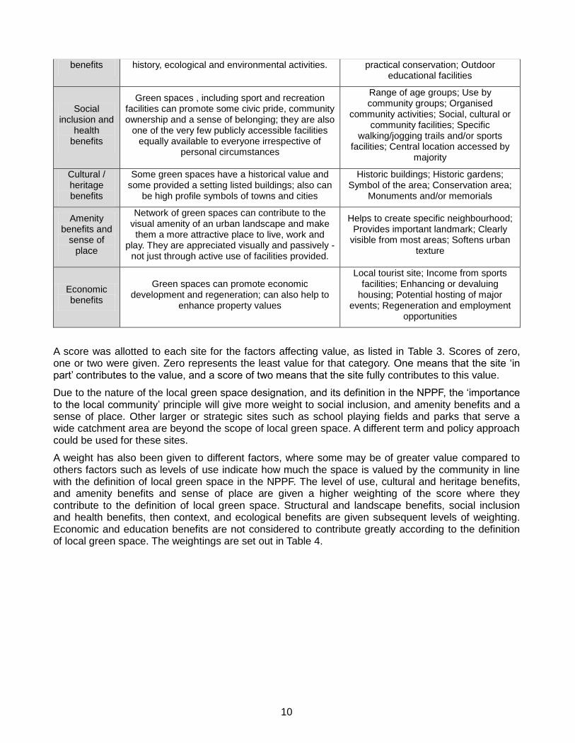
benefits history, ecological and environmental activities. practical conservation; Outdoor educational facilities
Social inclusion and
health benefits
Green spaces , including sport and recreation facilities can promote some civic pride, community ownership and a sense of belonging; they are also
one of the very few publicly accessible facilities equally available to everyone irrespective of
personal circumstances
Range of age groups; Use by community groups; Organised
community activities; Social, cultural or community facilities; Specific
walking/jogging trails and/or sports facilities; Central location accessed by
majority
Cultural / heritage benefits
Some green spaces have a historical value and some provided a setting listed buildings; also can
be high profile symbols of towns and cities
Historic buildings; Historic gardens; Symbol of the area; Conservation area;
Monuments and/or memorials
Amenity benefits and
sense of place
Network of green spaces can contribute to the visual amenity of an urban landscape and make them a more attractive place to live, work and
play. They are appreciated visually and passively - not just through active use of facilities provided.
Helps to create specific neighbourhood; Provides important landmark; Clearly
visible from most areas; Softens urban texture
Economic benefits
Green spaces can promote economic development and regeneration; can also help to
enhance property values
Local tourist site; Income from sports facilities; Enhancing or devaluing
housing; Potential hosting of major events; Regeneration and employment
opportunities
A score was allotted to each site for the factors affecting value, as listed in Table 3. Scores of zero, one or two were given. Zero represents the least value for that category. One means that the site ‘in part’ contributes to the value, and a score of two means that the site fully contributes to this value.
Due to the nature of the local green space designation, and its definition in the NPPF, the ‘importance to the local community’ principle will give more weight to social inclusion, and amenity benefits and a sense of place. Other larger or strategic sites such as school playing fields and parks that serve a wide catchment area are beyond the scope of local green space. A different term and policy approach could be used for these sites.
A weight has also been given to different factors, where some may be of greater value compared to others factors such as levels of use indicate how much the space is valued by the community in line with the definition of local green space in the NPPF. The level of use, cultural and heritage benefits, and amenity benefits and sense of place are given a higher weighting of the score where they contribute to the definition of local green space. Structural and landscape benefits, social inclusion and health benefits, then context, and ecological benefits are given subsequent levels of weighting. Economic and education benefits are not considered to contribute greatly according to the definition of local green space. The weightings are set out in Table 4.
11
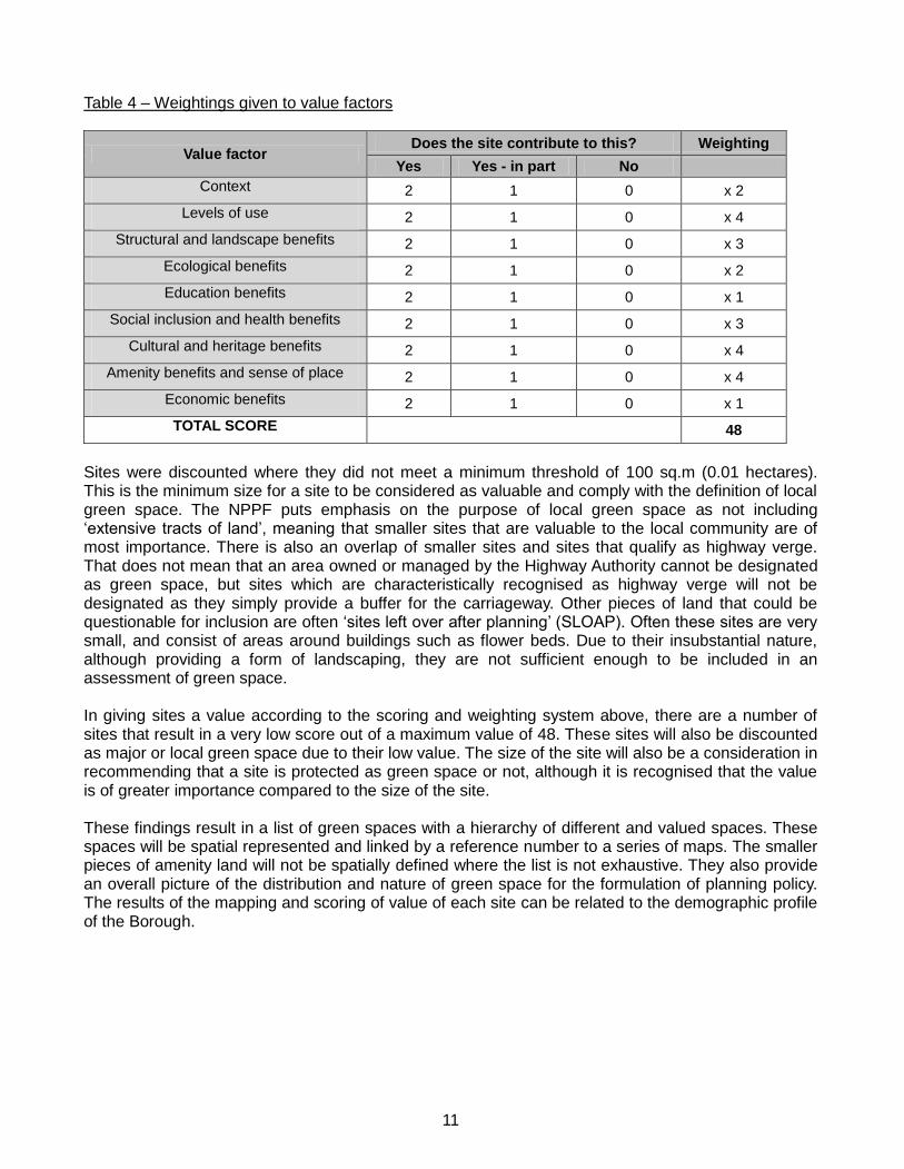
Table 4 – Weightings given to value factors
Value factor Does the site contribute to this? Weighting
Yes Yes - in part No
Context 2 1 0 x 2
Levels of use 2 1 0 x 4
Structural and landscape benefits 2 1 0 x 3
Ecological benefits 2 1 0 x 2
Education benefits 2 1 0 x 1
Social inclusion and health benefits 2 1 0 x 3
Cultural and heritage benefits 2 1 0 x 4
Amenity benefits and sense of place 2 1 0 x 4
Economic benefits 2 1 0 x 1
TOTAL SCORE 48
Sites were discounted where they did not meet a minimum threshold of 100 sq.m (0.01 hectares). This is the minimum size for a site to be considered as valuable and comply with the definition of local green space. The NPPF puts emphasis on the purpose of local green space as not including ‘extensive tracts of land’, meaning that smaller sites that are valuable to the local community are of most importance. There is also an overlap of smaller sites and sites that qualify as highway verge. That does not mean that an area owned or managed by the Highway Authority cannot be designated as green space, but sites which are characteristically recognised as highway verge will not be designated as they simply provide a buffer for the carriageway. Other pieces of land that could be questionable for inclusion are often ‘sites left over after planning’ (SLOAP). Often these sites are very small, and consist of areas around buildings such as flower beds. Due to their insubstantial nature, although providing a form of landscaping, they are not sufficient enough to be included in an assessment of green space. In giving sites a value according to the scoring and weighting system above, there are a number of sites that result in a very low score out of a maximum value of 48. These sites will also be discounted as major or local green space due to their low value. The size of the site will also be a consideration in recommending that a site is protected as green space or not, although it is recognised that the value is of greater importance compared to the size of the site. These findings result in a list of green spaces with a hierarchy of different and valued spaces. These spaces will be spatial represented and linked by a reference number to a series of maps. The smaller pieces of amenity land will not be spatially defined where the list is not exhaustive. They also provide an overall picture of the distribution and nature of green space for the formulation of planning policy. The results of the mapping and scoring of value of each site can be related to the demographic profile of the Borough.

12
4. Site assessment findings
Overall a total of 591 sites were identified as green space or amenity land, according to the typology in the Companion Guide to PPG17. Of these, 93 sites overlapped existing urban open land as designated in the HLP 2003. Table 5 divides the sites into types, and compares size and scores.
Assessment by type
Table 5 illustrates the number of sites by type. The total and average size by type is also given, together with the average score for that type of site. Some of the types have just a few sites within that category, and therefore can be more problematic in generalising results. Types that are few in number such as allotments, cemeteries and outdoor sports facilities are mainly all already allocated as urban open land.
Table 5 – Summary of all types of green spaces identified in the Borough
Number of
sites Total size area (ha)
Average size area (sq.m)
Average score
Allotment 8 10.85 13,563 21
Amenity green 337 57.77 1,714 13
Cemetery 6 5.15 8,583 28
Green corridor 62 14.54 2,345 10
Highway verge 88 5.41 615 7
No function (reservoir) 1 10.30 103,000 10
Outdoor sports facility 2 10.4 5,200 28
Park 27 72.77 26,952 30
Playing field 24 51.71 21,546 23
Semi natural green space 26 17.64 6,785 9
TOTAL 575 256.86 4,346 13
Existing urban open land 93 178 22,238 24
It is clear that ‘amenity greens’ form a large majority of the types of green space in the Borough, comprising almost 60% of the sites identified. In terms of size, amenity greens do not contribute as much as other types, such as parks or outdoor sports facilities. However amenity greens do have a good value level compared to some other types, such as semi natural green space and highway verges. Amenity greens tend to provide a more useable space for people, and can provide other benefits.
There are also a large number of sites which are within the 0.01 hectare threshold which are defined as highway verge. Given the large area that these sites cover collectively, they are not actually identified as having high value. Out of all types, highway verges achieve the lowest score on average, as these sites are basic. Generally the value is limited to providing structural and landscape benefits, and if large enough, amenity benefits and a sense of place. The range of scores given for highway verges is from 0 to 16 (out of 48). It is noted that there may well be value in some highway verges, but it is also recognised that 80% of these sites were given a value of 10 or less. Most of the highway verge sites identified with a score of more than 11 are more than 200 sqm in size. Some of these sites make a valuable contribution towards green space and infrastructure.

13
It is clear that green corridors contribute to green space in the Borough’s main towns and villages. These include both footpaths and Greenways, and linear sites that provide green links between more formal green spaces, particularly to the benefit of local biodiversity. The assessment does not cover rights of way/Greenways that are within the Green Belt, and Greenways comprising cycle routes in urban areas.
It is noted that the only site identified to have ‘no function’ is a set of covered reservoirs in Bushey Heath which are currently designated as urban open land in the HLP 2003. It is given a low score, but covers a large area.
Urban Open Land
Existing urban open land includes all types as listed in the typology of the Companion Guide to PPG17. Allotments, amenity greens, cemeteries, outdoor sports facilities, parks, playing fields and semi natural green space have been identified in the assessment to contribute towards open land in the Borough. The covered reservoirs are also included, and one example of a highway verge has also been identified as existing open land. In addition to the 93 sites currently identified as urban open land, it is recognised that several boundaries and layouts of some of the existing sites are likely to change as a result of the reassessment. This might possibly be due to development undertaken at individual sites since 2003. It is also noted that a number of sites are very small in comparison to the larger parks and playing fields in the urban open land designation. The purpose that is served by various existing urban open land sites may fit better within the local green space designation, where the primary role of the site is for the amenity of the local community.
Appendix B contains a table of the planning applications identified for playing fields, parks, and outdoor sports facilities. There have been no planning applications for allotments or cemeteries within urban areas, and so it can be assumed that the character of the open land at cemeteries and allotments will have been maintained. The designation is not considered to hinder change at allotments and cemeteries, which are sites that do not often require planning applications for new development.
Playing fields, which are located on primary and secondary school sites within urban areas, received the most planning applications, of which 70% of applications were approved. A further 20% were consultations from the County Council, where no objections were raised by the Local Planning Authority. Six of the 55 planning applications were either refused or objection was raised in line with the HLP 2003. Schools generally benefit from having playing fields associated with the building. There is also the inevitable pressure on this land for increased classroom capacity or need for improved facilities to comply with education standards.
The mapping illustrates that proposals at school sites have respected the designation and the requirements contained within the policy. The local planning authority has been generally successful in determining planning applications in line with the development plan in this regard. Planning applications for school sites that are managed by the County Council as the local education authority are also determined by them as the planning authority. These applications are more difficult to monitor in the same way.
14
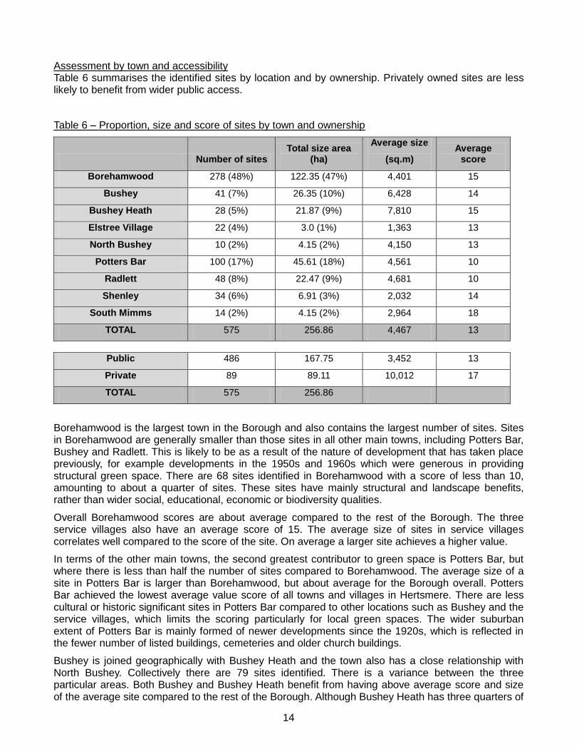
Assessment by town and accessibility Table 6 summarises the identified sites by location and by ownership. Privately owned sites are less likely to benefit from wider public access.
Table 6 – Proportion, size and score of sites by town and ownership
Number of sites Total size area
(ha)
Average size
(sq.m) Average
score
Borehamwood 278 (48%) 122.35 (47%) 4,401 15
Bushey 41 (7%) 26.35 (10%) 6,428 14
Bushey Heath 28 (5%) 21.87 (9%) 7,810 15
Elstree Village 22 (4%) 3.0 (1%) 1,363 13
North Bushey 10 (2%) 4.15 (2%) 4,150 13
Potters Bar 100 (17%) 45.61 (18%) 4,561 10
Radlett 48 (8%) 22.47 (9%) 4,681 10
Shenley 34 (6%) 6.91 (3%) 2,032 14
South Mimms 14 (2%) 4.15 (2%) 2,964 18
TOTAL 575 256.86 4,467 13
Public 486 167.75 3,452 13
Private 89 89.11 10,012 17
TOTAL 575 256.86
Borehamwood is the largest town in the Borough and also contains the largest number of sites. Sites in Borehamwood are generally smaller than those sites in all other main towns, including Potters Bar, Bushey and Radlett. This is likely to be as a result of the nature of development that has taken place previously, for example developments in the 1950s and 1960s which were generous in providing structural green space. There are 68 sites identified in Borehamwood with a score of less than 10, amounting to about a quarter of sites. These sites have mainly structural and landscape benefits, rather than wider social, educational, economic or biodiversity qualities.
Overall Borehamwood scores are about average compared to the rest of the Borough. The three service villages also have an average score of 15. The average size of sites in service villages correlates well compared to the score of the site. On average a larger site achieves a higher value.
In terms of the other main towns, the second greatest contributor to green space is Potters Bar, but where there is less than half the number of sites compared to Borehamwood. The average size of a site in Potters Bar is larger than Borehamwood, but about average for the Borough overall. Potters Bar achieved the lowest average value score of all towns and villages in Hertsmere. There are less cultural or historic significant sites in Potters Bar compared to other locations such as Bushey and the service villages, which limits the scoring particularly for local green spaces. The wider suburban extent of Potters Bar is mainly formed of newer developments since the 1920s, which is reflected in the fewer number of listed buildings, cemeteries and older church buildings.
Bushey is joined geographically with Bushey Heath and the town also has a close relationship with North Bushey. Collectively there are 79 sites identified. There is a variance between the three particular areas. Both Bushey and Bushey Heath benefit from having above average score and size of the average site compared to the rest of the Borough. Although Bushey Heath has three quarters of

15
the number of sites as Bushey itself, the total area is almost the same. The character of sites in Bushey and Bushey Heath is quite different, where almost half of sites in Bushey Heath are privately owned, rather than accessible to the public. Where sites are private, there may be no access to the site, or operated on a commercial basis thereby limiting accessibility to the general public. The quality of private green spaces may well be good and substantial in size, but it should be recognised that there is a limit to the usability and accessibility of these sites.
Sites in Bushey are of an above average size and score compared to the rest of the Borough. There are a number of culturally or historically significant sites, which add to the value of sites, and a number of purposely managed parks and gardens. In the suburban areas of Bushey there are fewer amenity greens compared to Borehamwood and Potters Bar, and a number of these are classified as highway verge.
North Bushey is a small area separated from Bushey by an area of Green Belt. There are ten sites here, with most being classed as amenity green or highway verge. Two of the highway verge are as large as or larger than some of the amenity greens and are thought to contribute to the green space in this area. Two of the sites in North Bushey are existing urban open land. Despite the very low average size of a site in this area, the average score is average compared to the Borough overall.
Radlett is the smallest of the main settlements, and achieves an average size site with slightly below average score compared to the Borough. Only four of the sites identified are private. Over half the sites are amenity greens, and just under half of all sites were either highway verge, green corridors or semi natural green space. This has lowered the average score, where generally higher scores relate to playing fields, allotments, parks and outdoor sports facilities.
Shenley and South Mimms, both service villages, have above average scores. When identifying sites in service villages there was an effort to ensure sites were only assessed that contributed to green space for the village. This excluded some larger sites on the periphery of the villages, or which may not be included in the future proposed 'development boundaries' for villages. Often villages achieve a high score where sites with cultural or historic significance, or are of amenity or social benefit to the local community. For example, cemeteries rate highly in that category, also with amenity benefits, sense of place, and ecological benefits.
Parks and school playing fields feature on the list of green spaces in villages, but have not previously been identified as urban open land, where villages are washed over by the Green Belt (excluding the part of Elstree not in the Green Belt). These are valued highly and their size is often comparable to similar sites in the towns and could be considered as potential sites for green space within proposed 'development boundaries' for villages.

16
Value scoring
The majority of sites achieved a value of between 11 and 20, including most amenity greens. It is generally the larger sites that are currently allocated as open land that get a score at the higher end. Over a third has a score of less than 10, meaning that their value is much less significant than other sites and may be limited by their size, location, form and accessibility. There are no sites in the Borough that obtain a score higher than 40. Sites that could achieve a score higher than that would have to be multipurpose, with a high degree of use by the public, and be of natural and historic interest.
Table 7 – Proportion of sites with a range of values
Score Number of sites Percentage
0 24 4%
1 to 10 192 33%
11 to 20 280 49%
21 to 30 62 11%
31 to 40 17 3%
41-48 0 0
TOTAL 575
In many cases the size of sites relates and correlates to the value that a site is given. Table 8 shows that almost half of sites are less than 999 sq.m, and that about 80% of the sites are less than 4,000 sq.m.
Table 8 – Proportion of sites within size ranges
Area Number of sites
Percentage Area Number of sites
Percentage
100 – 499 sq.m 166 29% 9,000 – 9,999 sq.m 4 0.5%
500 – 999 sq.m 116 20% 1 – 1.9 ha 29 5%
1,000 – 1,999 sq.m 97 17% 2 – 2.9 ha 10 2%
2,000 – 2,999 sq.m 55 10% 3 – 3.9 ha 3 0.5%
3,000 – 3,999 sq.m 31 5% 4 – 4.9 ha 7 1%
4,000 – 4,999 sq.m 13 2% 5 – 5.9 ha 2 0.5%
5,000 – 5,999 sq.m 11 2% 6 – 7.9 ha 3 0.5%
6,000 – 6,999 sq.m 12 2% 8 – 9.9 ha 2 0.5%
7,000 – 7,999 sq.m 9 1% 10 – 12 ha 2 0.5%
8,000 – 8,999 sq.m 3 0.5% TOTAL 575

17
5. Designation Analysis
The results highlight the main characteristics of green space in Hertsmere. This section analyses the future designation of urban open land as Major Green Space, and identification of sites as Local Green Space and Minor Amenity Land. A separate technical supplement lists all of the sites assessed and how they were scored. The approach has sought to be as consistent as possible where similar situations arise in different locations, and has developed some standardised approach to specific issues. However, every site has been considered on a case by case basis and there may be some sites that have been included beyond defined thresholds.
Spatial representation
The pyramid format can be used to represent the typology recommended for use in Hertsmere. The top of the pyramid is major green space, which is the largest in size, then local green space, and minor amenity land at the bottom, of which there are the most sites and smallest in size.
Figure 2 – Pyramid typology of green space in Hertsmere
Generally, major green space are sites that are more than 1 hectare, but when sites are less it may still be recommended due to their type. The scores for major green spaces are from 10 to 34. Sites have only been considered as a local green space if they have a score of more than 10, which indicates that it would have a level of social, amenity or environmental benefits. The minimum threshold for local green space is 100 sq.m. Sites identified as minor amenity land are often very small or a score of less than 10, although the list of sites is not exhaustive so thresholds for size and score are not defined.
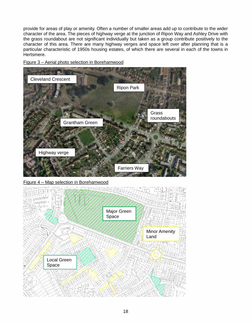
The aerial photo and map in Figures 2 and 3 give an example of how these three designations work in practise. Ripon Park is a designated public park and is maintained by the local authority. It is currently allocated as urban open land and will be reallocated as major green space. It is the largest site and only one of this type in this example.
There are three sites in this example that are recommended to be allocated as local green space, including the square at Grantham Green, land at Farriers Way and the play area at Cleveland Crescent. They are smaller sites compared to Ripon Park, but are considered to be a more localised provision that are valuable to the immediate surrounding community.
The remaining sites are much smaller, and mainly have a landscaping and structural role in the network of green infrastructure. There are a large number of these smaller sites, which are not able to
Major Green Space
Local Green Space
Minor Amenity Land
18
provide for areas of play or amenity. Often a number of smaller areas add up to contribute to the wider character of the area. The pieces of highway verge at the junction of Ripon Way and Ashley Drive with the grass roundabout are not significant individually but taken as a group contribute positively to the character of this area. There are many highway verges and space left over after planning that is a particular characteristic of 1950s housing estates, of which there are several in each of the towns in Hertsmere.
Figure 3 – Aerial photo selection in Borehamwood
Figure 4 – Map selection in Borehamwood
Ripon Park
Grantham Green
Highway verge
Grass roundabouts
Farriers Way
Cleveland Crescent
Major Green Space
Local Green Space
Minor Amenity Land

19
Major Green Space designation review
The review of all existing urban open land in Hertsmere highlighted a number of changes that have taken place at sites on the ground. Development of new strategic housing sites (HLP Policy H3 on Surplus School sites in Borehamwood) and other small scale changes at sites have changed the layout of buildings. A number of inconsistencies in existing designations have been found where some sites include areas of car parking and buildings. These have been removed from the designation to ensure consistency. Site boundaries have been reviewed to reflect these changes.
Table 9 illustrates the sites which are recommended to be designated as major green space. These sites are generally the largest sites, and are of good value. The aim was to select sites that are more than 1 hectare, but when sites are less it may still be recommended due to their type and function. For example, there are a number of school playing fields and allotments which are less than 1 hectare, but it is recommended that uses including playing fields, allotments and cemeteries should be defined as major green space. The scores for major green spaces are from 10 to 34. The lowest scored site is the covered reservoirs in Bushey Heath, which is a large site but with little value as green space otherwise. The next highest score is 18.
Table 9 – List of Major Green Spaces
Site ref. Site location Town Type Size Accessibility
BH 001 Hillmead nature Park Bushey Heath Park 1.3 Public
BH 003 WIndmill Recreation Ground/Allotments Bushey Heath Park/Allotments 2.22 Public
BH 004 Land at R/O 2-44 Richfield Road Bushey Heath Semi natural green space
1.19 Private
BH 005 Playing field at Bushey Heath Primary Bushey Heath Playing Field 0.8 Private
BH 006 Covered reservoirs Bushey Heath No function 10.3 Private
BU 002 The Moatfield Playing fields Bushey Park 4.89 Public
BU 003 King George Recreation Ground Bushey Park 8.68 Public
BU 004 Playing field at Bournehall Primary Bushey Playing Field 1.34 Private
BU 005 Playing field at Little Reddings Primary Bushey Playing Field 2.13 Private
BU 006 Playing field at Merry Hill School Bushey Playing Field 1.44 Private
BU 022 Land and Cemetery at St James' Church Bushey Cemetery 1.8 Public
BW 003 Organ Hall open space Borehamwood Park 2.7 Public
BW 008 Old Haberdashers Sports Ground Borehamwood Playing Field 4.05 Private
BW 009 Aberford Park Haggerston Road Borehamwood Park 1.09 Public
BW 010 Brook Meadow recreation ground Borehamwood Park 2.4 Public
BW 011 Leeming Park Borehamwood Park 1.6 Public
BW 013 Aberford Park Borehamwood Park 6.7 Public
BW 014 Playing fields at Aycliffe Road Borehamwood Park 5.4 Public
BW 015 Land between Aycliffe Road and Thirsk Borehamwood Amenity Green 2.7 Public
BW 022 Allotment gardens off Shenley Road Borehamwood Allotment 1.97 Private
BW 023 Meadow Park football grounds Borehamwood Outdoor sports 8.6 Public
BW 024-9 Potters Wood and land at Studio Way Borehamwood Semi natural green space
4.49 Public
BW 030 Tempsford Green playing fields Borehamwood Amenity Green 4 Public
BW 031 Maxwell Hillside Park (south) Borehamwood Park 2 Public
BW 032 Maxwell Hillside Park (north) Borehamwood Park 1.9 Public
BW 034 Playing field at Woodside and Cowley Borehamwood Playing Field 3.6 Private
BW 035 Land at Shakespeare Drive Borehamwood Park 1.1 Public
BW 037a Kenilworth Park Borehamwood Park 2.3 Public
BW 040 Ripon Park Borehamwood Park 4.4 Public
BW 041 Playing field at Yavneh/Monksmead Borehamwood Playing Field 4.5 Private
BW 042 Playing field at Hertswood Upper Borehamwood Playing Field 5.9 Private
BW 043 Playing field at Kenilworth school Borehamwood Playing Field 2.1 Private
BW 044 Land R/O 100 Aycliffe Road Borehamwood Amenity green 2.1 Private
BW 045 Playing field at Parkside Primary Borehamwood Playing Field 1.6 Private

20
BW 046 Playing field at Summerswood Primary Borehamwood Playing Field 1.7 Private
BW 047 Playing field at St Teresa's Primary Borehamwood Playing Field 1 Private
BW 048 Playing field at Saffrom Green Primary Borehamwood Playing Field 1.3 Private
BW 049 Playing field at Meryfield Community
Primary Borehamwood Playing Field 3.5 Private
EV 009 Playing field at St Nicholas Primary Elstree Village Playing Field 0.8 Private
EV 010 Cemetery, St Nicholas Church Elstree Village Cemetery 0.3 Private
NB 006 Playing field at Highwood Primary North Bushey Playing Field 2.7 Private
PB 004 land R/O Willow Way and Mutton Lane Potters Bar Cemetery 1.4 Private
PB 005 Allotments at High View Gardens Potters Bar Allotment 3.7 Private
PB 014 Potters Bar Cricket and Bowls Club Potters Bar Outdoor sports 1.8 Public
PB 015 Parkfield Potters Bar Park 11.5 Public
PB 016 Oakmere Potters Bar Park 6.49 Public
PB 021 Playing field at Lochinver House Potters Bar Playing Field 1.54 Private
PB 022 Playing field at Mount Grace School Potters Bar Playing Field 4.7 Private
PB 026 Elm Court Community Centre Potters Bar Playing Field 1.8 Private
PB 027 Playing field at Cranborne Primary Potters Bar Playing Field 1.43 Private
PB 029 Allotment at Aberdale Gardens Potters Bar Allotment 0.55 Private
RT 014 Playing field at Fair Field Junior School Radlett Playing Field 1.58 Private
RT 17-22 Allotments Elm Walk Radlett Park/Allotments 6.72 Public
SH 001 Land east of Andrews Close Shenley Park 1.2 Public
SH 027 Playing Fields at Shenley Primary Shenley Playing Field 0.76 Private
SM 003 Playing fields at St Giles School South Mimms Playing Field 0.9 Private
Major Green Space policy recommendation
The results of the site assessments confirm that open land areas relate to the provision of larger green spaces. These are parks, outdoor sports facilities, cemeteries, allotments and playing fields. Further to the reallocation of the spatial designation of the previous urban open land to major green space, there is a need to review of the effectiveness of HLP 2003 Policy L3. The main principle of development at urban open land sites is that ‘Urban Open Land Areas…will be required to retain the essentially open character’. It goes on to detail that proposals should be:
Ancillary or complementary which would upgrade the existing authorised uses;
Additional built facilities must be limited and small scale in both extent and volume;
Provision of public access where there is currently no right;
Provision of facilities to meet an identified community need within that particular area;
In compliance with other policies in the Local Plan; and
Supported by a detailed written statement.
It is due to the character and function that some of these types of major green space will have buildings within the curtilage of the site, and that some of these may be temporary. Given the number of applications at school sites that are essential to meet the need of education standards, as required by the Office for Standards in Education, Children’s services and Skills (OFSTED), it is reasonable to endorse the approach where school buildings and community facilities are not ‘washed over’ by the designation. The designation will continue to cover hard standing and the occasional building at allotments, cemeteries, outdoor sports facilities and parks.
It is recommended that the main principle of retaining the character of major green space is brought forward to any new policy. One key change is proposed for Policy L3, where there is a mixed meaning between ancillary and complementary in bullet point (i). Ancillary means subordinate, and complementary indicates related, but could be of any use or scale of development that may be inappropriate. Complementary may have different implications depending on the use of the site. A
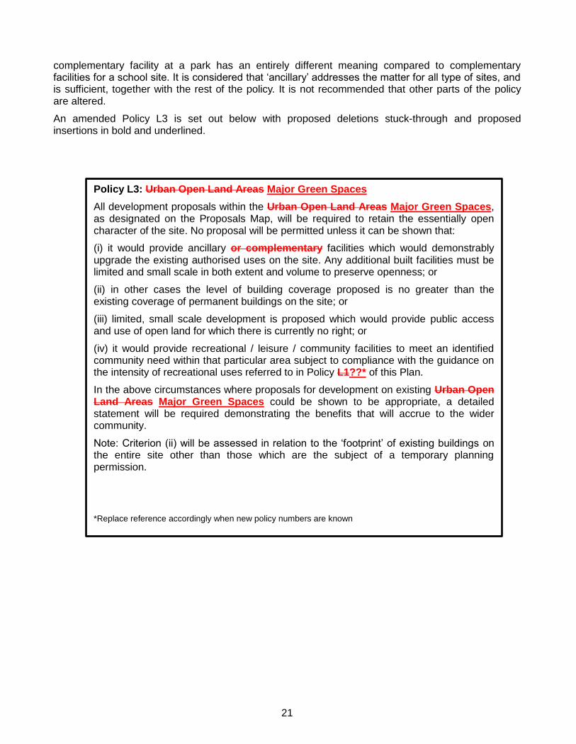
21
complementary facility at a park has an entirely different meaning compared to complementary facilities for a school site. It is considered that ‘ancillary’ addresses the matter for all type of sites, and is sufficient, together with the rest of the policy. It is not recommended that other parts of the policy are altered.
An amended Policy L3 is set out below with proposed deletions stuck-through and proposed insertions in bold and underlined.
Policy L3: Urban Open Land Areas Major Green Spaces
All development proposals within the Urban Open Land Areas Major Green Spaces, as designated on the Proposals Map, will be required to retain the essentially open character of the site. No proposal will be permitted unless it can be shown that:
(i) it would provide ancillary or complementary facilities which would demonstrably upgrade the existing authorised uses on the site. Any additional built facilities must be limited and small scale in both extent and volume to preserve openness; or
(ii) in other cases the level of building coverage proposed is no greater than the existing coverage of permanent buildings on the site; or
(iii) limited, small scale development is proposed which would provide public access and use of open land for which there is currently no right; or
(iv) it would provide recreational / leisure / community facilities to meet an identified community need within that particular area subject to compliance with the guidance on the intensity of recreational uses referred to in Policy L1??* of this Plan.
In the above circumstances where proposals for development on existing Urban Open Land Areas Major Green Spaces could be shown to be appropriate, a detailed statement will be required demonstrating the benefits that will accrue to the wider community.
Note: Criterion (ii) will be assessed in relation to the ‘footprint’ of existing buildings on the entire site other than those which are the subject of a temporary planning permission.
*Replace reference accordingly when new policy numbers are known
22
Local Green Space designation
The designation of local green space relates to a range of types, including playgrounds, amenity greens, highway verges and semi natural green spaces. The designation depends on the sites size and score, as discussed previously.
As noted in the Chapter 4 of this document, there are a significant number of sites that have a score of zero, and also many with less than 10. Sites have only been considered as a local green space if they have a score of 11 or more, which indicates that it would have a level of social, amenity or environmental benefits. There is no change in the threshold for the size of a site, where a small site of 100 sq.m may still have a high value, and therefore comply with the requirements of designating local green space. Designations have been reviewed on a town by town basis, where the characteristic and needs of different towns and villages vary from place to place, rather than on a Borough wide basis, where the outcome could be distorted by failing to reflect local circumstances.
Table 10 summarises the list of recommended local green spaces by town, type, size and accessibility. Appendix C includes maps of all proposed major and local green space site allocations.
Table 10 – List of Local Green Spaces
Site ref. Site location Town Type Size Accessibility
BH 002 Mary Forsdyke Garden Bushey Heath Park 0.72 Public
BH 007 The Paddocks Bushey Heath Semi natural green space
0.58 Private
BH 028 Land between 22/24 Prowse Avenue Bushey Heath Amenity green 0.45 Public
BU 001 Bushey Rose Garden Bushey Park 0.53 Public
BU 015 War Memorial at Sparrows Herne Bushey Amenity green 0.04 Public
BU 043 Land at Brick Kiln Close Bushey Amenity green 0.33 Public
BW 001 Land at Tomkins Close and Bairstow Cl Borehamwood Amenity green 0.3 Public
BW 004 Land at Wetherby Road Borehamwood Amenity green 0.12 Public
BW 012 Land at Gateshead Road/Beech Drive Borehamwood Amenity green 0.13 Public
BW 016 Walshford Green Borehamwood Amenity Green 0.64 Public
BW 017 Land at Ayot Path and Walshford Way Borehamwood Amenity green 0.13 Public
BW 018 Land at Ayot Path and Stapylton Road Borehamwood Amenity green 0.13 Public
BW 019 Land R/O Stapylton Road Borehamwood Amenity green 0.33 Public
BW 020 Clarendon Park Borehamwood Amenity green 0.28 Public
BW 021 All Saints graveyard Borehamwood Cemetery 0.39 Private
BW 033 Land on corner of Byron Ave/Vale Road Borehamwood Park 0.18 Public
BW 036 Land within Studio Way estate Borehamwood Amenity green 0.73 Public
BW 038 Land off Farriers Way Borehamwood Park 0.69 Public
BW 039 Land at Grantham Green Borehamwood Amenity green 0.3 Public
BW 185 War Memorial Shenley Road Borehamwood Amenity green 0.26 Public
BW 186 Land at Wordsworth Gardens Borehamwood Amenity green 0.28 Public
BW 190 Land at 24-50 Milton Drive Borehamwood Amenity green 0.1 Public
BW 191 Land at 29-57 Milton Drive Borehamwood Amenity green 0.13 Public
BW 198 Land at Lemsford Court Borehamwood Amenity green 0.2 Public
BW 204 Land at Cleveland Crescent Borehamwood Amenity green 0.21 Public
BW 214 Land at Lakeside Borehamwood Amenity green 0.21 Private
BW 236 Playground at Fell Path Borehamwood Amenity green 0.04 Public
BW 239 Land at Hunter Walk Borehamwood Amenity green 0.5 Public
BW 249 Land at Windsor Close Borehamwood Amenity green 0.16 Public
EV 013 War Memorial Elstree Hill North Elstree Village Amenity green 0.13 Public
NB 001 Land at Forest Walk North Bushey Amenity green 0.6 Public
NB 004 Land at Scottswood Close North Bushey Amenity green 0.18 Public
NB 009 Playground at Hartswood Close North Bushey Amenity green 0.04 Public
PB 003 Land at Willow Way Potters Bar Park 0.4 Public
PB 013 Land at Abingdon Place Potters Bar Amenity green 0.19 Public
PB 020 Land at Church Road/Osborne Road Potters Bar Amenity green 0.36 Public

23
PB 025 Land at Cranborne Crescent Potters Bar Amenity green 0.35 Public
PB 030 Land at Berkley Close Potters Bar Amenity green 0.16 Public
PB 031 Land at Rushfield Potters Bar Amenity Green 0.35 Public
PB 034 Former allotment gardens at Elmroyd
Avenue Potters Bar
Semi natural green space
0.29 Private
RT 001 Land at Williams Way Radlett Amenity Green 0.27 Public
RT 002 Land at Canons Close Radlett Highway verge 0.2 Public
RT 011 Square at Phillimore Place Radlett Amenity green 0.28 Public
RT 021 Scrubbitts Wood (north) Radlett Semi natural green space
0.7 Public
RT 023 Scrubbitts Wood (south) Radlett Semi natural green space
0.39 Public
RT 024 Land Rear of Christ Church Radlett Amenity Green 0.61 Public
RT 025 Cemetery, Watling Street Radlett Cemetery 0.54 Public
RT 029 Lauteral Green (Tykeside Gardens) Radlett Park 0.41 Public
RT 030 Land opposite Station Road Radlett Amenity green 0.22 Public
SH 014 Land at Cockle Way Shenley Amenity green 0.09 Public
SH 016 Land at Ribston Close Shenley Amenity green 0.13 Public
SH 017 Land at Grace Avenue Shenley Amenity Green 1.4 Public
SH 023 Green at Mead Road Shenley Amenity Green 0.33 Public
SH 026 Pond and War Memorial London Road Shenley Amenity green 0.06 Public
SH 028 Playground at Mead Road Shenley Amenity green 0.06 Public
SH 029 Playground at Anderson Road Shenley Amenity green 0.13 Public
SM 002 Playground at Blanche Lane South Mimms Park 0.96 Public
SM 004 Cemetery, St Giles Church South Mimms Cemetery 0.72 Private
SM 005 War Memorial St Albans Road South Mimms Amenity green 0.04 Public
SM 011 Playground at Brookside South Mimms Amenity green 0.06 Public
The most local green spaces are located within Borehamwood, which has the Borough’s largest population and whose post-war development is characterised by these areas of green space. The number of sites here is also considered to be appropriate given the level of proposed housing contained in the policies of the RCS 2011 and the pressure to build within the existing urban area. Other local green spaces are otherwise more evenly distributed across towns and villages.
Local Green Space policy recommendation
There is not an existing policy in the HLP 2003 which relates to local green space. Based on the requirements of the NPPF the following policy is proposed:
Proposed Policy: Local Green Space
Proposals that would result in the loss of green spaces which are valuable to the local community as identified on the Proposals Map, and/or would have a negative impact on the visual amenity, historic significance, recreational value, tranquillity or biodiversity of those spaces will be refused.
24
Minor Amenity Land policy recommendation
The existing policy D22 on amenity greens in the HLP 2003 is still relevant to apply to all other green spaces that cannot be recommended at major or local green space, which have been identified and scored. Amenity greens and highway verge have been identified as minor amenity land, which all contribute to green infrastructure.
The policy currently contains no standards to allow a more informed decision to be made in planning applications, especially where a site has a low value. In such instances it might be considered that potential benefits of development would outweigh the loss of ‘minor amenity land’. The principle that such green spaces should not be lost will be carried forward but it is recommended that more detail in terms of values should be added to the policy. Such spaces often allow for the break-up of built form and hard surfaced areas. The contribution that trees have within green spaces is also significant. Where the other green space is essentially a highway verge, the proportion of hard surfaced area compared to green area should be considered should a planning application be made, together with the usability of the site for amenity benefits.
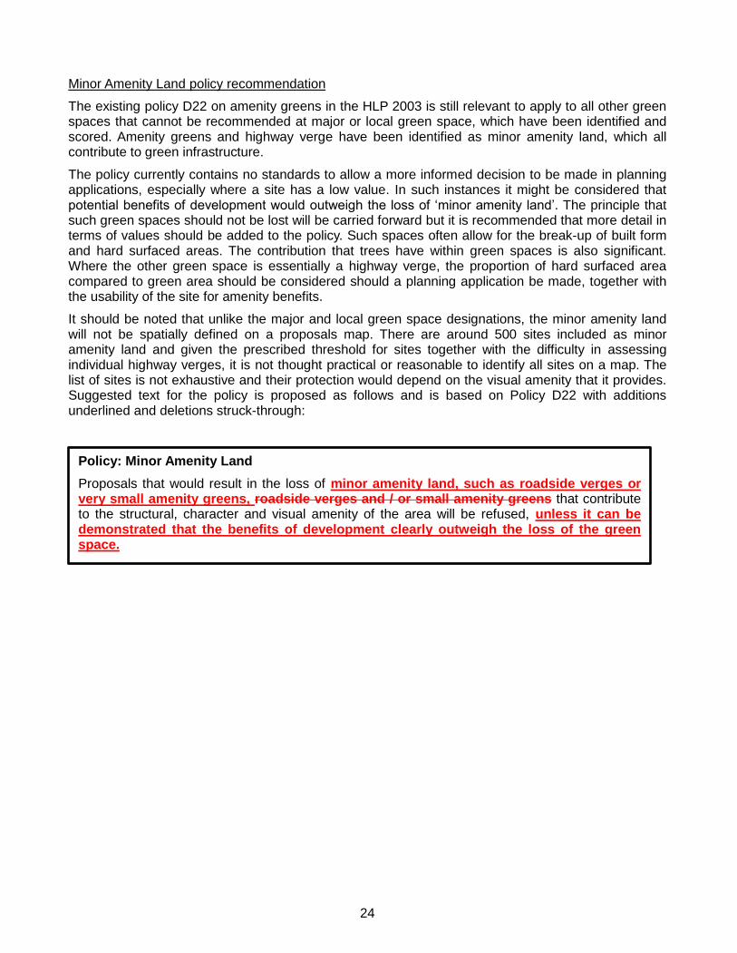
It should be noted that unlike the major and local green space designations, the minor amenity land will not be spatially defined on a proposals map. There are around 500 sites included as minor amenity land and given the prescribed threshold for sites together with the difficulty in assessing individual highway verges, it is not thought practical or reasonable to identify all sites on a map. The list of sites is not exhaustive and their protection would depend on the visual amenity that it provides. Suggested text for the policy is proposed as follows and is based on Policy D22 with additions underlined and deletions struck-through:
Policy: Minor Amenity Land
Proposals that would result in the loss of minor amenity land, such as roadside verges or very small amenity greens, roadside verges and / or small amenity greens that contribute to the structural, character and visual amenity of the area will be refused, unless it can be demonstrated that the benefits of development clearly outweigh the loss of the green space.

25
Appendix A – Sample site assessment table
Site information Value
Site ref.
Site locatio
n
Tow
n
Type
Cu
rrent d
esignatio
n
New
de
signatio
n
Size
Acce
ssibility
Co
ntext
Co
ntext (w
eighted
x2)
Levels of u
se
Levels of u
se (we
ighted
x4)
Structu
ral and
land
scape b
enefits
Structu
ral and
land
scape b
enefits
(weigh
ted x3
)
Ecolo
gical ben
efits
Ecolo
gical ben
efits (weigh
ted x2
)
Edu
cation
ben
efits
Edu
cation
ben
efits (weigh
ted x1
)
Social in
clusio
n an
d h
ealth b
enefits
Social in
clusio
n an
d h
ealth b
enefits
(weigh
ted x3
)
Cu
ltural an
d h
eritage ben
efits
Cu
ltural an
d h
eritage ben
efits
(weigh
ted x4
)
Am
enity b
ene
fits and
sense o
f place
Am
enity b
ene
fits and
sense o
f place
(weigh
ted x4
)
Econ
om
ic ben
efits
Econ
om
ic ben
efits (weigh
ted x1
)
Total score (max.
48)
XX
00
0
Test site
Test to
wn
Test typ
e
Existing
Pro
po
sed
ha
Test
2
4
2
8
2
6
2
4
2
2
2
6
2
8
2
8
2
2
48

26
Appendix B – Planning applications for Urban Open Land between 2000 and 2012
Parks
Outdoor sports facilities
Application Decision Number
Application Decision Number
TP/01/0422 Granted
8
TP/11/1528 Granted
7
TP/01/0892 Granted
TP/07/0250 Granted
TP/04/1227 Granted
TP/03/0778 Granted
TP/07/0667 Granted
TP/01/0866 Granted
TP/08/0935 Granted
TP/08/1123 Granted
TP/08/1236 Granted
TP/11/1772 Granted
TP/10/1740 Granted
TP/02/0727 Granted (upheld at appeal)
TP/11/1232 Granted
TP/01/0095 Prior approval not required 1
TP/07/0688 Refused 1
TP/07/1986 Refused 1
TOTAL 9
TOTAL 9
Playing fields
Application Decision Number
TP/04/0219 Dismissed at appeal 1
TP/01/0303 Granted
38
TP/05/0414 Granted
TP/01/0735 Granted
TP/02/0318 Granted
TP/10/1482 Granted
TP/12/1159 Granted
TP/02/0108 Granted
TP/02/0384 Granted
TP/06/1051 Granted
TP/07/0906 Granted
TP/08/0900 Granted
TP/02/0302 Granted
TP/02/0695 Granted
TP/05/1294 Granted
TP/05/1378 Granted
TP/05/1447 Granted
TP/07/1964 Granted
TP/10/2482 Granted
TP/11/1128 Granted
TP/10/2053 Granted
TP/01/1015 Granted
TP/10/2534 Granted
TP/07/1200 Granted
TP/08/0474 Granted
TP/04/0633 Granted
TP/06/0882 Granted
TP/05/0681 Granted

27
TP/12/0333 Granted
TP/10/1936 Granted
TP/06/1060 Granted
TP/07/0406 Granted
TP/05/0132 Granted
TP/10/2400 Granted
TP/10/0765 Granted (HCC)
TP/11/2154 Granted (HCC)
TP/10/2528 Granted (HCC)
TP/07/2244 Granted (HCC)
TP/10/0962 Granted (HCC)
TP/01/0142 Raised no objection
10
TP/02/0458 Raised no objection
TP/00/0218 Raised no objection
TP/01/0141 Raised no objection
TP/08/0210 Raised no objection
TP/02/0896 Raised no objection
TP/00/0658 Raised no objection
TP/00/0883 Raised no objection
TP/06/1140 Raised no objection
TP/12/0824 Raised no objection
TP/03/0474 Raised objection
3 TP/11/1090 Raised objection
TP/11/0891 Raised objection
TP/06/1409 Refused
3 TP/03/0902 Refused
TP/09/0475 Refused
TOTAL 55

28
Appendix C – Maps of proposed Major Green Space and Local Green Space Borehamwood Centre -
East -

29
Centre-east -
South-east -
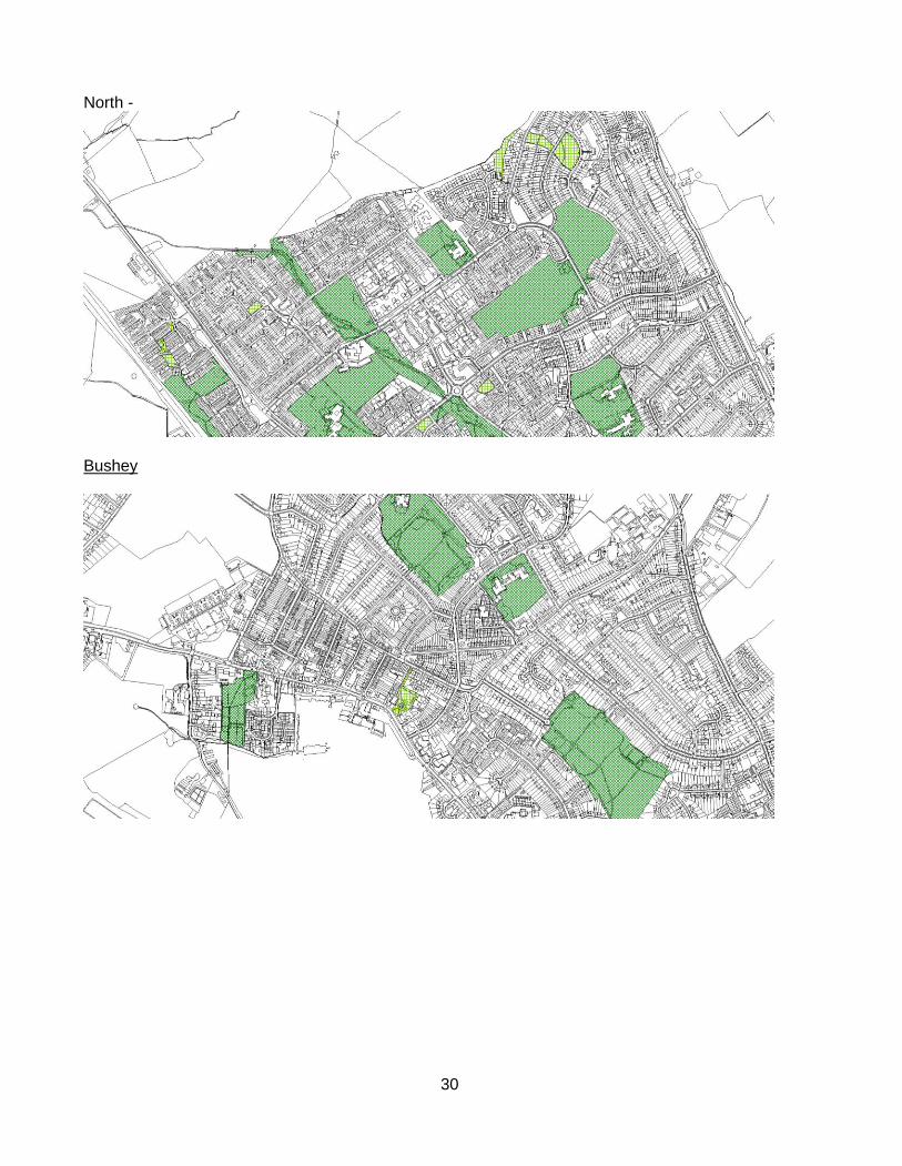
30
North -
Bushey
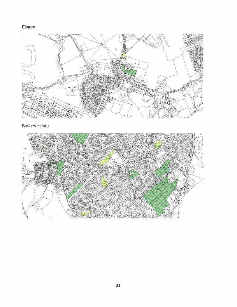
31
Elstree
Bushey Heath

32
North Bushey
Potters Bar West -

33
South -
East -

34
North -
Radlett South -
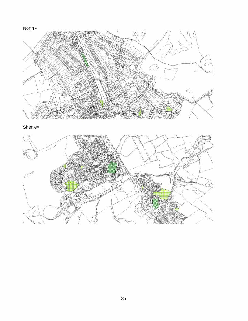
35
North -
Shenley

36
South Mimms